Article

Do Protected Areas Exacerbate Rural Shrinkage? Research on China’s Gaoligong Mountain Region from an Institutional-Space Perspective

1
Key Laboratory of Regional Sustainable Development Modeling, Institute of Geographic Sciences and Natural Resources Research, Chinese Academy of Sciences, Beijing 100101, China
2
College of Resources and Environment, Chinese Academy of Sciences, Beijing 100049, China
3
College of Urban and Environmental Science, Central China Normal University, Wuhan 430079,China
*
Author to whom correspondence should be addressed.
Forests 2022, 13(10), 1567; https://doi.org/10.3390/f13101567
Submission received: 19 August 2022 / Revised: 17 September 2022 / Accepted: 21 September 2022 / Published: 26 September 2022
(This article belongs to the Special Issue Nature-Based Tourism and Nature Conservation Activation by Tourism)

Abstract

:
China’s territorial development is subject to multiple influences in new political, social, and economic contexts. In an era of increased globalization and urbanization, the construction of protected areas (PAs) as part of globalization has had a “double-edged sword” effect on China’s rural development; their impact has left a deep imprint on rural development, and understanding their relationship helps to achieve multiple goals. This paper discusses the changes in the urban–town–village system in the region where the Gaoligong Mountain Nature Reserve is located in China and attempts to analyze the impact of PAs on rural shrinkage. We found that the institutional embedding of PAs as a policy tool has led to regional differentiation and village shrinkage and expansion. Secondly, PAs stimulate changes in evolutionary paths in different types of villages by common forces through demographic, factor, capital, and policy constraints or incentives; however, the formation of new industrial spaces of ecotourism has a damping effect. We conclude that the embedding of PAs has led to a reconfiguration of spatial rights and capital in regional development, changing the original path of rural development. Adaptive development strategies must be established to safeguard this in future development.

1. Introduction

Shrinkage and expansion are two opposite and unified aspects in the civilizational process of human settlement development [1]. They occur in cities and rural areas [2,3,4]. Global economization and urbanization have led to and are more profoundly affecting this process, including the late industrialization in Europe and North America, the post-Ford economy in developing countries, and the transition from planned to market economies in Western Europe. These exacerbate the very different situation of high-concentration and withering development, resulting in the emergence and spread of rural abandonment, old age, and hollowing out [5]. The hypothesis of “long-term growth” or even “infinite growth” is only a phasic phenomenon [6,7,8]. Mainly due to falling fertility rates, many cities and regions are likely to continue to “shrink” in the coming decades, especially in China, even with some increases in population due to migration [9]. China’s resident population in rural areas is decreasing at a rate of 1.6% per year, while residential land is growing at a rate of 1% per year—a dilemma of “shrinking people and expanding land” [1]. This poses a huge challenge for shrinking regions: how to maintain better public services and retain investment in businesses and infrastructure despite the plight of a declining population. This phenomenon is more evident in areas protected by nature reserve policies than in common areas [10,11,12].
In 2019, the Chinese government proposed “Building a nature reserve system with national parks as the mainstay” to promote China’s ecological civilization in conjunction with the global system of PAs and the conservation of natural ecosystems and to support the achievement of the Sustainable Development Goals (SDGs) in order to promote the social–ecological systems of the global goals [13]. By 2025, China will have a natural reserve system that includes national parks, nature reserves, and nature parks [14]. Among these, nature parks include various feature categories, such as forest, geological, and World Heritage Sites [15]. Human activities are prohibited in nature reserves. In contrast, national parks and nature parks can develop ecotourism without compromising ecological conservation, especially through the building of entrance towns to encourage the development of recreation and hospitality services. Therefore, the construction of different types of PAs actually forms institutional spaces with special control elements. These factors are intertwined and will affect China’s rural development even more profoundly in terms of ecological migration, forced relocation, and loss of productive resources.
The essence of rural shrinkage is the weakening of built-up areas, function, and character due to shrinking population and industry. Rural shrinkage is a global issue, but coping strategies are locally adaptive. Numerous cases have proved that natural disasters, epidemic diseases, economic crises, structural transformation, armed conflicts, and unnatural disasters can trigger the shrinkage and expansion of settlements [16,17,18]. As a global model of environmental development, the construction of PAs is profoundly affecting the changes in rural settlements, resulting in a range of phenomena, such as the decline and even the disappearance of villages. Rural shrinkage is usually described in terms of concepts such as “hollowing out (village)”, “over-thinning”, and even terms with strong emotional coloring, such as “recession”, “withering”, and “crisis”. “More people and less land” is China’s primary national condition, especially in mountainous and canyon areas. The phenomenon of rural shrinkage is equally present [19]. The interventions in the institutional spaces of PAs will encroach on capital, such as land and forest products, on which people depend for their livelihoods. So, has the construction of PAs exacerbated rural shrinkage, and how can the development of PAs and rural areas be better coordinated to make them sustainable? In the past 20 years, as rural development has received more attention, there have been many studies on rural land-use change [20], rural transformation [21], rural hollowing mechanisms [22], and rural area evolution [23]. Research on rural shrinkage remains insufficient. How do PAs affect rural shrinkage or expansion through institutional space? This question has not been effectively answered, especially under China’s public land ownership and individual contracting system. Therefore, this paper explores whether the institutional spaces of PAs merely bring about the regional characteristics of rural shrinkage.
This paper aims to apply the concept of institutional space to the Gaoligong Mountains region of Southwest China to answer three research questions. First, how to understand the impact of the construction of PAs on rural shrinkage or expansion from the perspective of institutional space? Second, how does the institutional space of a PA affect this process from the perspective of population and land-use change? Thirdly, can this evolving rural development demonstrate a more extraordinary sustainability?

2. Theoretical Framework

2.1. Institutions and Institutional Space

An institution is a series of rules, law-abiding procedures, and moral and ethical norms of behavior that have been developed. There are formal institutions (such as laws, regulations, ordinances, decrees, standards, norms, etc.) and informal institutions (such as customs, codes of conduct, etc.) along with their implementation mechanisms [24]. Once an institution is established in a certain range, it will have a binding effect on the types and numbers of actors in that range, and the combinations and relationships of natural capital, human capital, social capital, and financial capital will change accordingly [21,25].
The institution of PAs can be understood as a series of laws and regulations, standard codes, and supervisory regulations formed for the protection of specific objects. Different types of PAs form different institutional spaces due to the different contents and intensities of constraints. The game of economic interests based on resource scarcity and spatial immovability leads to the reconfiguration of infrastructures and public service facilities in the areas where PAs are located, forming different development constraints and incentives. For example, the construction of nature reserves restricts the use of forest resources, planting and breeding, and some other traditional behaviors in the experimental zones and the buffer zones [26], including corresponding activity intensities and contents. New institutions construct new spaces. Different institutional arrangements produce different types of spaces, assign different ecological service values to the places where they are located, and guide adaptation towards the reproduction of new physical and social spaces [27].

2.2. Rural Shrinkage and Smart Decline

Over the past decade, researchers have argued that “smart decline” belongs to regional development patterns. The term refers to green infrastructure developments that focus on improving the quality of life of existing residents by preserving ecological and economic possibilities for the restoration of declining areas, rather than attempting to expand development [28]. It is a planning and management strategy proposed in backward economies when growth supremacy fails to address the root causes of existing and new urban problems (such as gentrification) and is defined by Popper as “planning for less: fewer people, fewer buildings, fewer land uses” [29]. Smart decline calls for acknowledging and respecting the reality of shrinking populations without completely rejecting “growth supremecism” [30], but rather emphasizing the need to confront decline head-on. Meanwhile, smart decline advocates a new philosophy of progressive economic growth and improved quality of life by actively reducing population sizes and construction and building-land areas to promote optimal development [31,32].
The well-known concept is the shrinking city, which was proposed to describe urban population reduction and economic decline in the post-industrialization process [33,34]. It has been widely used in the rust belts of post-industrial Europe and the United States. Hospers analyzed the shrinkage of European cities and found that it includes counteracting shrinkage and accepting shrinkage [35]. However, there is a paucity of research applying this concept to rural areas in Europe and the United States [36]. In particular, it is important to note that population loss and hollowing out due to rural shrinkage in China has become a serious and well-known problem [37].
The core of smart recession is to face up to the second transformation path from the level of internal improvement. This is the case for rural decline, which scholars have applied to rural research in the past ten years. Rural shrinkage is not the same as rural decline. In the context of rural decline, the optimization of the rural development is to be achieved under conditions of corresponding changes in the way rural production is organized. The concept of rural decline has been applied to Japan, Malaysia, Denmark, and other places to explain sustainable rural development strategies under shrewd shrinkage [38,39]. In Sweden, Josefina Syssner believes that extremely sparse population structures and ambitious welfare assignments are closely related to population decrease [40,41]. Smart decline in rural regions focuses on promoting the transformation of planning concepts, reducing construction scales, and transforming development strategies to promote sustainable growth.

2.3. Protected Areas and Rural Development

The construction of PAs is an effective means of coping with the sharp decline in natural system biodiversity, improving ecosystem services, and ensuring ecological security. However, it can affect the development of internal and surrounding rural communities to varying degrees, generating various constraints, such as cost-effectiveness, development restrictions, and social culture, which often lead to reactive community development [42,43]. When PAs are established, extreme protection or laissez-faire can be ineffective for rural development [44]. The closer the distance to the core zone, the more obvious the conflict between humans and wild animals and the greater the possibility of policy control and regulation. In addition, PAs can restrict productive activities in strictly ecological PAs, including logging, traditional hunting, and grazing, which is tantamount to cutting off the livelihoods of indigenous peoples and is an indirect form of eviction. It has left villages hollowing, leaving vacant houses, unoccupied land, and degraded public services [45].
On the other hand, the surrounding areas allow the development of ecological organic industry, ecotourism, etc. Under the guidance of policies and industries, populations will also gather in the peripheral tourist attractions, and industrial villages will improve the vitality of the rural economy to the profit of the communities in question [46]. Rural development in re-concentrated areas needs smart growth [47], which means the search for growth that simultaneously satisfies economic and community development, and environmental protection focuses on where and how new growth should take place by replacing the original production and living spaces. This migration of rural populations, guided by PAs, triggers migration between villages, resulting in some villages shrinking while others grow. Generally speaking, balancing the positive and negative effects of rural shrinkage brought about by PAs is closely related to factors such as national conditions, management models, and incentive policies [48]. However, in other places, such as the communities around the Philippine Forest Reserve, the socio-economic status of the communities close to the reserve will be higher, which has become a clear counterexample [49].
PAs are managed for multiple, often competing, goals, including biodiversity conservation, community livelihoods, and tourism [50]. Conflicts can arise where biodiversity conservation objectives restrict resource access to forest communities. Similarly, different levels of prohibitions can cause livelihood impacts, such as restricted production modes and operations and reduced income and job opportunities for community residents, and can hinder the achievement of conservation goals [51,52,53]. Community attitudes toward PAs are primarily influenced by costs and benefits, household size, occupation, education level, and awareness of or participation in livelihood projects [54], so investigating the natural and management characteristics of PAs allows for greater robustness [55]. Given this, local communities are able to contribute to broader biodiversity conservation goals as they manage their surroundings and establish PAs. However, rural communities neglect natural ecology and wildlife conservation when there is low efficiency and livelihood resources are inadequate [56]. Therefore, it is necessary to meet the social, economic, cultural, and spiritual needs of present and future generations through reasonable financial resources and administrative jurisdictional authority configurations and management using renewable resources and environmental capacity [57].
Rural shrinkage occurs more frequently in a globalizing world [58]. In many countries and regions, population decrease in rural areas is more common [59], including Europe, the United States, and parts of Asia [60], and has become a severe threat to the sustainable development of rural areas [61]. The need for studies of rural decline is evident in a postmodern time to create a new rural reconstruction model [62]. Rural decline must be achieved through the subtraction of abandoned space and facility renewal to achieve an organic combination of rational withdrawal and reorganization of resources, improve land-use efficiency, promote the optimization and adjustment of rural spatial structures, and find economic opportunities [63].

2.4. Institutional Spaces, Protected Areas, and Rural Development

Different institutional arrangements produce different spaces. Nature reserves and World Natural Heritage sites are two different types of PAs. The construction of a natural reserve limits the protection and development activities of an area by defining different functional zones. Afterwards, it will shape very different activities, intensities, and contents, and shape the spatial characteristics and spatial values of corresponding institutions, such as recreational values, ecological and environmental values, etc. In heritage areas, the market value of natural resources can be activated through the development of ecotourism. Since nature reserves and natural heritage sites require different levels of conservation intensity, they are also subject to different control regimes, which in turn have different impacts on regional development. It follows that the establishment of different institutions of PAs will embed new management requirements for sites, which is equivalent to the formation of new institutional spaces to accommodate the reproduction of new material and social spaces, so the production logics and processes within a certain range will be recombined and connected spatially, thus forming a new spatial structure and spatial form [27].
Therefore, through the above analysis, we built an innovative research framework around institutions, reserves, and spaces to analyze the evolutionary path of rural shrinkage (Figure 1). Before the construction of a PA, the development of a region will behave as a natural development according to the pattern of the established urban–town system. Once a PA is constructed, it is equivalent to one or more types of reserve systems embedded directly within the space of the administrative area. It will create heterogeneous spatial patches whose development paths will change according to the institutional control of the PA in which they are located, including changes to the inputs and outputs of different regions in terms of the economy, public facilities, social services, culture, etc., thus changing the original town system’s hierarchical structure. Such changes brought about by the embedding of the PA will have a reciprocal effect on the development of different places in the region, which in turn will guide the direction of rural population outflow and inflow. If this new pattern is to be maintained in a sustainable direction, it must be optimized by adopting the concept of smart decline to avoid the problems of systemic instability in the early stages of the new pattern, so that the deterioration of rural shrinkage can be avoided in the foreseeable period.

3. Data Source and Methodology

3.1. Case Study Background

The Gaoligong Mountain area (GMA) is located at the intersection of the three geographic regions of East Asia, South Asia, and the Qinghai–Tibet Plateau, with a surface area of 17,000 km2(Figure 2). It is mainly located in Gongshan County, Yunnan Province. The area has been known to Western science since the early 1860s, the British zoologist Anderson having led Burmese expeditions in 1868 and 1875 and collected birds, amphibians, and fish specimens. In June 2003, it was named a World Heritage site by the World Heritage Centre.
There are 5 townships and 25 administrative villages with a stable population of about 30,000 in Gongshan County. Since 2003, the population of the rural areas has been in a steady state. The incidence of poverty in different townships in Gongshan County reaches 56%–75%. Following the establishment of the Gaoligong Mountain Nature Reserve in 1986, traditional logging and forest resource extraction were banned, thus limiting the development of local industries and decreasing employment opportunities. After becoming a World Heritage Site, the Chinese government’s pledge to stop issuing prospecting and mining licenses in favor of trying to achieve ecological conservation and address poverty through the development of ecotourism has become a complex issue for local governments. Since 2010, the Chinese government has been on the road to poverty alleviation. Through the construction of the forest ecological protection system, the Forestry Bureau of Gongshan County provides at least one ranger position for each family, and each person receives a monthly subsidy of RMB 800. Guided by the ecotourism industry, the rural population continues to migrate, and those towns with faster industrial development have become areas of population inflow, while those villages in the interior of nature reserves have experienced exoduses.
From 2018 to 2019, all five towns and townships had negative growth, with rural population growth of −1.94% and urban population growth of −1.23%, but the poverty incidence dropped to 2.4%. From 2019 to 2020, except for the township of Pinzhonglo (0.05%) and Dulongjiang (0.25%), others are in negative growth (−0.80%). Except for growth in Jiangxiang (0.25), other towns and townships all experienced negative growth (−0.80%). It was not rural–urban migration but rural–rural migration that occurred. Although the region has implemented political ambitions to develop PAs and regional economic and social cohesion and has implemented some physical interventions in tackling rural development, the most fundamental factor is the local barriers of the PAs. Therefore, we have focused on the relationship between PAs and rural settlement changes.

3.2. Data Sources

This paper used an analysis method combining a quantitative model and remote sensing image verification. Firstly, we established the measurement method of rural shrinkage to determine whether rural shrinkage was in fact occurring. Then, villages with large changes were selected for comparative verification of the rural construction landscape during the study period.
In order to obtain detailed research data and investigate the field, a research team of three teachers and four students went to Gongshan County from 9 to 18 October 2021. We adopted a participatory survey method and invited the Governor of Gongshan County, the Director of the County Forestry Bureau, the County Natural Resources Bureau, and the Science and Technology Bureau as guides and interpreters to conduct a region-wide survey of the five townships in Gongshan County. Firstly, the research team held meetings and talks with the town government to listen to their explanations and analyses of the issue. Questions asked concerned the differences in systems between the Gaoligong Mountain Nature Reserve and the Three Rivers World Heritage Site, the impact of both on the local area after their construction, and the ways in which the two systems constrain and incentivize local development; secondly, field interviews were carried out with local residents and we asked them about the types of employment and changes in income levels after the construction of the conservancy; thirdly, we selected a sample line survey to comprehensively observe the villages distributed on both sides of the Nujiang River and the Dulongjiang River.
The data used in this paper include remote sensing image data, land-use type data, and demographic and economic statistical data. Their sources were: (1) remote sensing image base map data, including DEMs, river systems, and other elements, from the China Water Economics Thematic vector data and historical image data resources collected by the Note Map Data Co., Ltd., on site; (2) land-use type data from a national land-use survey database released by the Chinese government, including two periods (phase two (2010) and phase three (2020)), which came from data released by the Chinese government; (3) demographic and economic data from various economic and social surveys in Gongshan County, as well as demographic data provided by the Civil Affairs Bureau of Gongshan County. Part of the population data came from the summary of the permanent population of the township in the seventh national census.

3.3. Methods

Given the poor availability of economic indicators broken down to rural areas, this paper defines rural shrinkage primarily in terms of population movement and land use. The difference between the permanent and registered populations reflects the population outflow, and the nature of land use was considered to judge the efficiency of resource utilization. Regarding rural shrinkage, the core indicators of shrinkage are population decline and vacant functions [64]. The definition of urban shrinkage is mainly marked by population loss, and some studies have added additional dimensions, such as economic recession and dilapidated spatial quality [65,66]. This article draws on the theory of shrinking cities and defines rural shrinkage as a permanent population less than the registered population or as permanent population decrease. Similarly, rural shrinkage includes population shrinkage, land-use shrinkage, industrial shrinkage, and cultural shrinkage. The decisive indicators are population shrinkage and land-use shrinkage. Therefore, this paper uses two indicators, population change and vacant residential land, to measure rural shrinkage. The difference between the resident population and the registered population reflects population movement. The increase or decrease in residential land reflects the change in rural construction land attributes.
First, we established a method for measuring the population shrinkage index (Su) based on the permanent population to directly reflect the rural population’s decrease. This article divided the study area into towns and villages and used the socio-economic indicators in the statistical yearbook to match them one by one. In order to reflect the overall situation of the permanent population, this paper selected permanent population data for analysis. The calculation formula used was:
S u = P r P u P r
where Su is the shrinkage measurement value based on the permanent population; Pr is the permanent rural population in the base year; and Pu is the permanent rural population.
On the other hand, we established a method for measuring rural shrinkage based on rural land use. Since rural shrinkage is mainly manifested in the control and abandonment of villagers’ houses, the difference in the plot ratio for rural residential land is slight [67]. The proportion of construction land corresponding to control and desertion was used as the basis for the shrinkage measurement. The proportion of the total area of construction land controlled and abandoned in a particular village was the contraction value of the village.
At this time, the land used for rural residential areas was determined. The land-use data used in this article were from “The Second National Land Survey in 2010” and “The Third National Land Survey in 2019” of Gongshan County. Due to the differences in the classification standards used in the two periods of data collection, to reduce the impact on the extraction of land categories, the data were refined. We converted the classification system of “The Third National Land Survey” into the classification system of “The Second National Land Survey” to carry out the unification of land-use types. Then, the land-use types were divided into twelve types, namely, cultivated land (01), garden land (02), woodland (03), grassland (04), commercial service land (05), industrial and mining storage land (06), residential land (07), public management and public service land (08), special-use land (09), transportation land (10), water area and water conservancy facility land (11), and other land (12). Using ArcGIS to extract the plots for residential land (07), the distribution of rural residential areas in the research area was obtained to calculate the land-use shrinkage index (Sc) using the data from the second and third national land surveys.
S c = A h A k A k
where Sc is the measurement value based on the shrinkage of residential land and   A h   and A k   represent the total construction land area at the end of the study and in the initial stage, respectively. If Sc is less than 0, it is in contraction; if is greater than 0, it is in expansion; if it is 0, it is stable.
To integrate the estimation of population shrinkage and land-use shrinkage and establish the composite shrinkage index (S) of rural shrinkage, the following formula was used:
S = S r / S c
where S r < 0, S c > 0 indicates that population shrinkage is dominant; S r > 0, S c < 0 indicates that residential land-use shrinkage is dominant; and   S r < 0, S c < 0 indicates that population shrinkage and residential land-use shrinkage are occurring simultaneously. If −1 < S r < 0, the degree of population shrinkage is less than the residential land-use shrinkage; if S r < −1, the degree of residential land-use shrinkage is less than the population shrinkage; and if S r > 0, S c > 0, this indicates no contraction but rather an expansion state.

4. Results

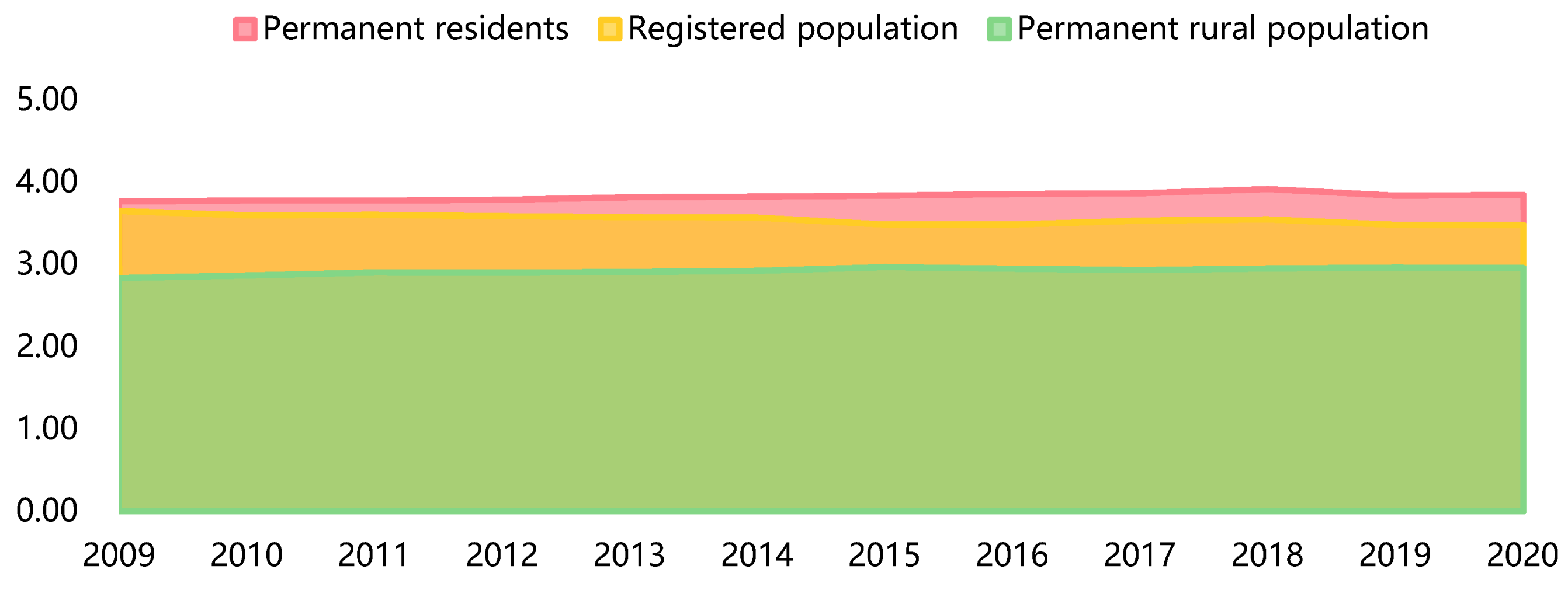
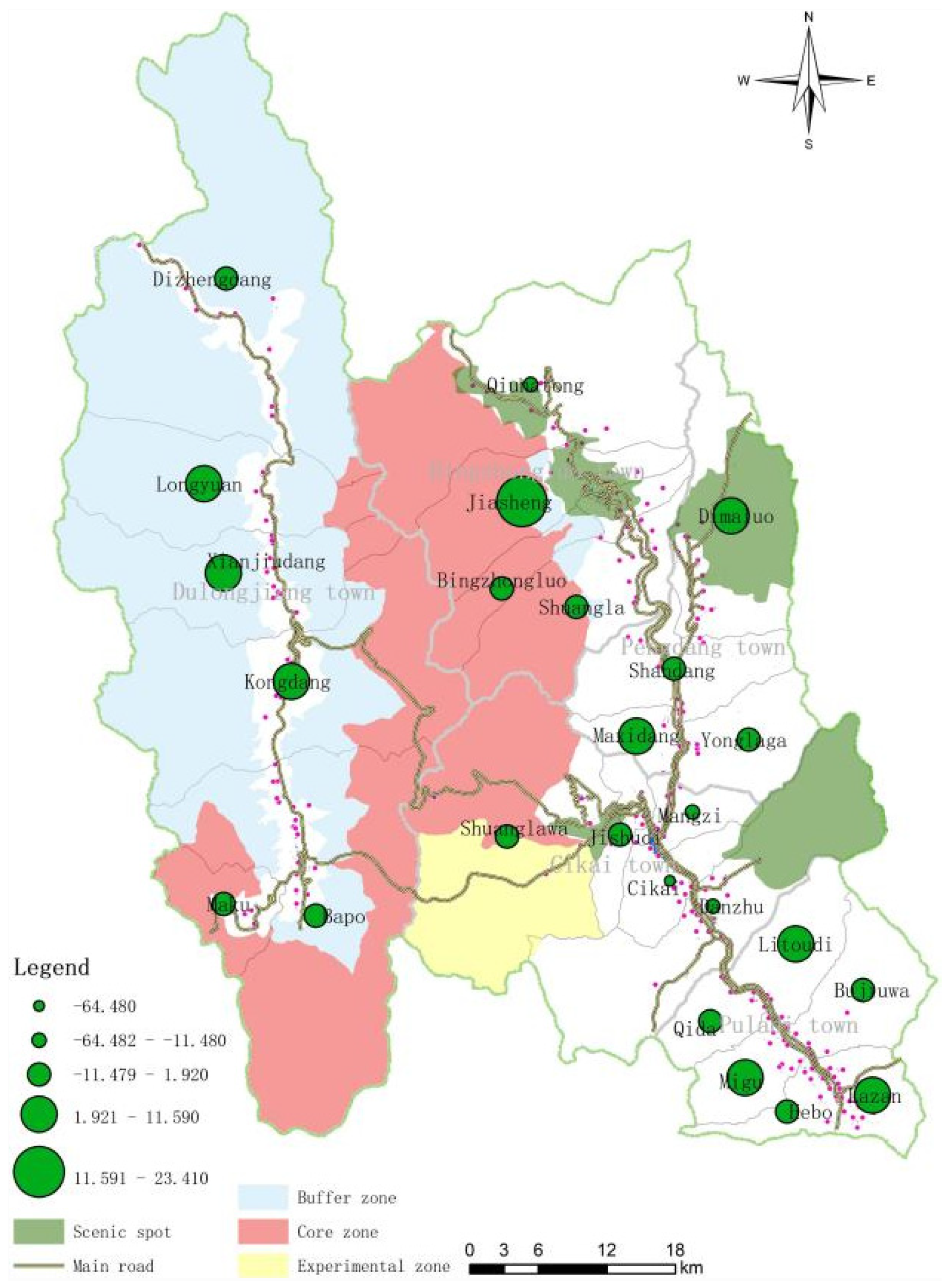
4.1. Coexistence of Rural Population Shrinkage and Growth

During the study period, the permanent population of the study area increased slightly (Figure 3). From 2009 to 2020, the permanent population increased by 1500 people, and the permanent population in rural areas increased by 1200 people. In comparison, the registered population of Gongshan County decreased by up to 1700, which was in contrast to the urbanization patterns in other urban areas in China. The urban population in the study area was declining, and the rural population in the administrative area was increasing. This was mainly due to barriers to the PA on urban land. On the other hand, there were more beautiful tourist destinations in the rural areas around the PA, which increased the rural population’s ability to absorb the tourist employment population. From 2009 to 2020, tourism revenue increased from RMB 60 million to RMB 303 million.
The increase in the overall population does not mean that the subordinate township and village levels were all growing. From the perspective of population changes in townships, towns and villages located in the primary traffic area and with representative scenic and recreational nodes of heritage sites showed population growth. Bingzhongluo Township increased by 521 people, Pengdang Township increased by 166, and Cikai Town and Dulongjiang Township increased by 166 and 220, respectively. The populations of Jiangxiang and Prati townships decreased by 728 and 559 people, respectively. Similar characteristics were also shown at the administrative village level. The administrative villages with reduced populations were often far from the central city and the main nodes of the heritage site, including Danzhu Village (−398), Hebo Village (−74), Mangzi Village (−71), Masidang Village (−35), Kongdang Village (−24), Qiunatong Village (−22), and Bujiuwa Village (−19). The administrative villages with increasing populations were mainly the villages near where the towns were located, including Bingzhongluo Village (595), Yonglaga Village (126), and Litoodi Village (203). See Appendix A for specific data.
In terms of the population contraction index (Table 1), the population underwent a slight expansion of 0.0549. The main reason for this was that local expansion was more significant than shrinkage. At the township level, except for Cikai Town, the other four towns were in a state of population expansion. The largest increase was observed for Prati Township (0.1411), followed by Bingzhongluo (0.0887) and Dulongjiang (0.0723). Pengdang Township underwent a minor population expansion (0.0301). At the village level, the six administrative villages were characterized by shrinking populations, including Mangzi Village (−0.05) and Danzhu Village (−0.17) in Cikai Town, Qiunatong Village (−0.02) in Bingzhongluo Township, Jia Sheng Village (−0.06) and Masidang Village (−0.07) in Pengdang Township, Kongdang Village (−0.02) in Dulongjiang Township, and Bujiuwa Village (−0.02) in Prati Town. The other administrative villages belonged to the population-expansion type, among which Bengzhongluo Village (0.33), Bapo Village (0.24), and Lazan (0.32) showed greater population expansion.

4.2. Diversification of Rural Land under the Growth of Ecological Land

Under the influence of the construction of the Gaoligong Mountain Nature Reserve, a dynamic reconstruction is taking place. From 2009 to 2019, the residential land areas generally showed a shrinking trend, from 51.79 hectares in 2009 to 50.90 hectares, with a shrinkage rate of 0.089 hectares/year. Cikai Township is the county seat of government and the administrative service center of Gongshan County and it has relatively good public service facilities and educational and medical resources. However, due to the constraints of the canyon topography, there is a serious shortage of land for industrial development and residential construction, and population loss and residential land reduction are still occurring. In 10 years, Cikai Township decreased by a total of 103.83 hectares, with Cikai Village decreasing the most, reaching −68.48 hectares.
Except for Cikai Township, other townships showed different trends of change. The added values of Bingzhongluo, Pengdang Township, and Dulongjiang Township exceeded 10 hectares. The increase in Prati Township was relatively tiny, being just 2.84 hectares. The main reason is that the three townships of Bingzhongluo, Dulongjiang, and Pengdang have relatively good heritage landscape resources. With improvements in access over the last decade, they are becoming important viewing and reception service points for heritage sites, attracting influxes of tourism and employee populations. At the village level, the administrative villages with residential land expansion are mainly concentrated in two types of areas (Figure 4). One includes the villages around scenic areas, such as Jiasheng Village (23.41), Maluo Village (11.59), and Kongdang Village (4.50). The other villages are in the middle of the traffic corridor, such as Masidang Village (7.59), Longyuan Village (3.99), Xianjiodang Village (2.44), Latodi Village (3.80), and Laza Village (3.59). On the contrary, those administrative villages that belong to the shrinking type are mainly those that are located in areas with large mountain slopes or at the edge of administrative areas, including Cikai Village (−68.48), Danzhu Village (−21.46), Hebo Village (−5.23), and Qiu That barrel village (−11.48).
Apart from the residential land, there are two conversion directions for other land uses. First, many lands were converted into ecological lands under the strict restrictions of the Gaoligong Mountain Nature Reserve. The scales of woodland, grassland, and garden land have increased significantly, and water area and water conservancy facility land has also increased. In addition, the economic function of land use has been strengthened, and a large amount of cultivated land has been converted into transportation land, public management and public service land, and commercial land. The scale of support for urbanization developments, such as facilities, road infrastructure, parks, and commercial services, has also increased significantly.
The trend for the land-use shrinkage index was more prominent (Table 1), with an overall mean of −0.0200. At the township level, Cikai (−0.5455) and Prati (−0.1023) exemplified shrinkage of land use. Dulongjiang (0.3657) and Bengzhonglo (0.1162) showed expansion. At the village level, ten administrative villages had land-use shrinkage status, including five administrative villages in Cikai Town, Qiunatong Village (−0.8150), and Shuangla Village (−0.1093) in Bingzhongluo Town, Xianyiudang Village (−0.0729) in Dulongjiang Township, Qida Village (0.1023), and Hebo Village (−0.2425) in Prathi Township.

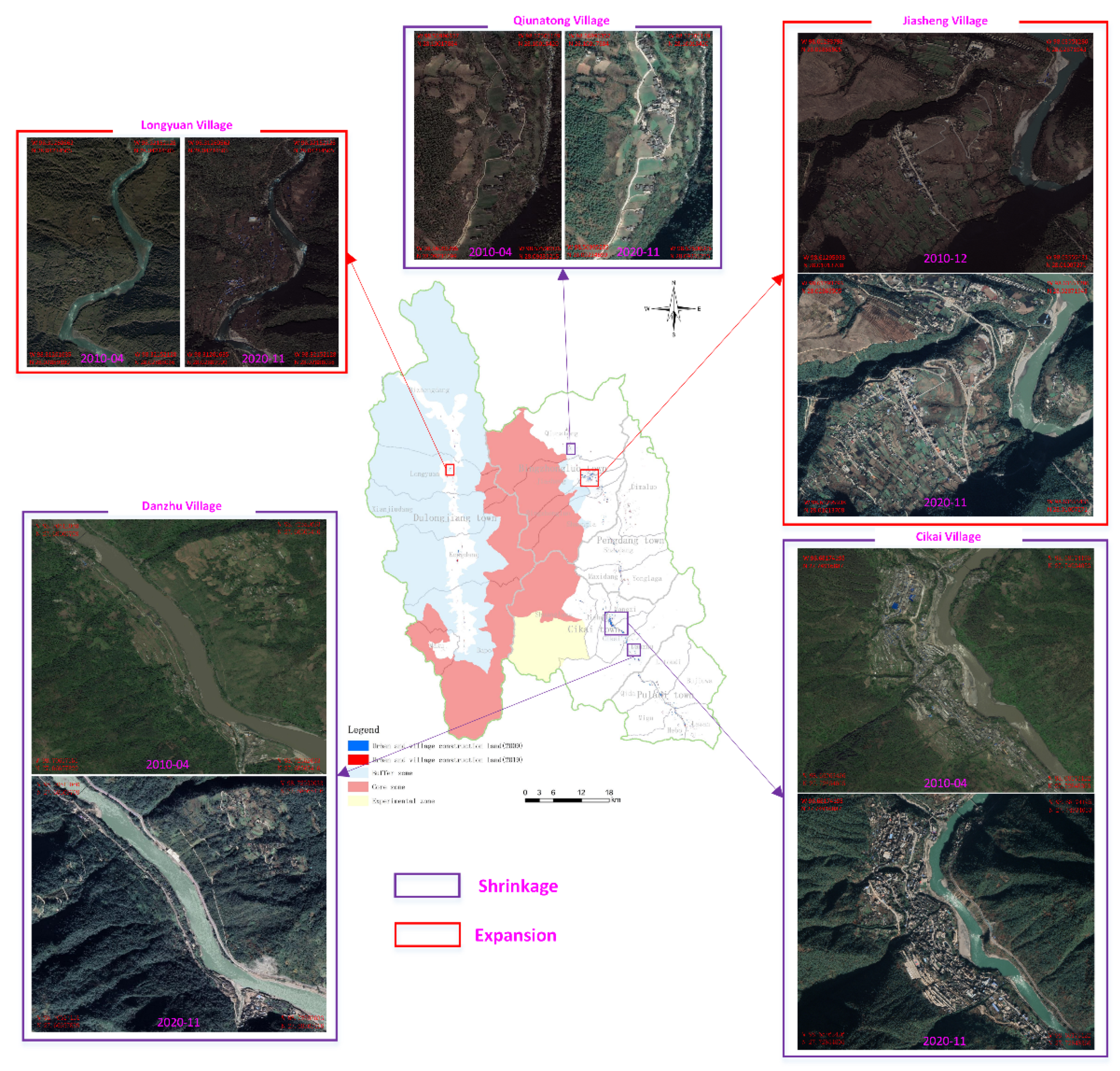
4.3. Two Different Scenarios of Rural Shrinkage and Expansion

The composite shrinkage index analysis shows that there is rural shrinkage in Gongshan County under the influence of the Gaoligong Mountain Nature Reserve and the Three Rivers World Heritage Site. The data reflected the shrinkage transmission at the township and administrative village levels (Table 1). Among the towns that are part of the rural shrinkage are the towns of Cikai and Prati, including five administrative villages in Cikai Town, Shuangla Village (−0.1830) in Bingzhongluo, Masidang Village (−0.0699) in Pengdang Township, Xianjiudang Village (−0.9602) and Kongdang Village (−0.0268) in Dulongjiang Township, and Lazan Village (2.5397), Litoudi Village (1.3373), Qida Village (−0.9775), and Hebo Village (−2.2887) in Prati Township. One of the anomalies is Jiasheng Village in Bingzhongluo Town. Its population is shrinking, but its land expansion is relatively large. The main reason is that Jiasheng Village is close to the tourist area of Bingzhongluo, and more tourist hotels have been built, resulting in outliers and a larger amount of land per capita. In addition, ten other administrative villages are also in a state of expansion.
The institutional construction of the Gaoligong Mountain Nature Reserve and the Three Rivers World Heritage Site has resulted in a series of ecological management and land-use restriction policies. Under this institutional spatial force, the scale of land use has in turn influenced and regulated population movement, thus creating a phenomenon of internal adjustment between townships and villages in Gongshan County. The construction of the Gaoligong Mountain Nature Reserve has to some extent limited the traditional use of natural ecological resources (logging, forest planting, aquaculture, etc.); on the other hand, because the World Heritage Site encourages the development of ecotourism industry, it has also opened another new development path for local people in the development model for a modern service industry led by tourism.
To further verify the correctness of the above results, we selected the shrinking and expanding villages with large changes for a comparison and verification of remote sensing images. Among them, Cikai Village, Danzhu Village, and Qiunatong Village were selected as tokens of the shrinkage type, and Jiasheng Village and Longyuan Village were selected as tokens of the expansion type. Comparing the remote sensing image data for these villages for 2010 and 2020 (Figure 5), it can be found that the measurement results are consistent with the increases and decreases in rural land.
Among them, the land-use shrinkage indexes for Cikai Village and Danzhu Village were −0.8364 and −0.5211, respectively. From 2010 to 2020, the spatial growth of residential land was not obvious in actual performance. The main reason for this situation is the renovation of old urban areas and the demolition and renovation of houses, resulting in a relatively high cost of living in the county, which leads to differences in the choices of different people. People with higher incomes will choose to live in the central city of Gongshan County to enjoy the convenient life and school education; people with lower incomes will not choose Cikai Village in order to reduce the cost of entry but go to nearby tourist towns with better land conditions and strong employment vitality.
The main reason for the shrinking land in Danju Village is that it is located on the left side of the river. The available flat land belongs to a north–south strip, but most of it is cultivated land where changes in the nature of use are prohibited. Therefore, there is also a lack of land for construction. With the loss of population, the shrinking houses are gradually turned into woodland and cultivated land for ecological conservation. Qiunatong Village is a very representative traditional village in the study area. On the one hand, the government wants to protect the original residential architectural landscape and prohibits arbitrary demolition and relocation [68,69]. However, public services and educational shortcomings are prominent, population loss is serious, and residential land is gradually shrinking.
Among these two expanding and developing villages, Jiasheng Village, near Bingzhongluo Town, has the most beautiful natural landscape resources and assumes the supporting service function of tourist reception. As a result, many tourist hotels and restaurants have been built in Jiasheng Village. The study found that although the population of Jiasheng Village has decreased, the scale of land use has increased. Longyuan Village is a key area for the development of Dulongjiang cultural tourism in Dulongjiang Township. The land here is flat and open and located on both sides of the main traffic. As a result, the local government started to build a centralized poverty-alleviation village in Longyuan Village in 2015, which affected the ecological environment. The concentration of families relocated from the Gaoligong Mountain Nature Reserve and the construction of more functional facilities in the tourism landscape to promote tourism services also led to expansion in the scale of land use, which is also more evident in Figure 5.

5. Discussion

5.1. Reconfiguration of Rural Development Factors under the Influence of Multiple Institutional Spaces

As seen from the above analysis, once PAs intervene in the administrative system, a double spatial force is generated, forcing population flows from areas subject to strict restrictions to new areas of tourism development activated by heritage sites, thus leading to a reconfiguration of various development factors at the regional level and changing urban–rural spatial relations and evolutionary paths. This phenomenon is consistent with the findings of Canavire-Bacarreza et al. (2013) on the impact of PAs on poverty in Bolivia [48]. Hospers’ research on rural shrinkage in Europe also found that imperfect urban policies will have negative impacts on rural changes [70].
However, multiple factors affect rural shrinkage. In Romania, the spatial reorganization of industries due to institutional reforms will affect employment opportunities, triggering a shift from growth to shrinkage [71]. Some countries that allow recreational opportunities in nature reserves, such as the Philippines, where tourism facilities can be built and where indigenous people are not forced to move out of nature reserves, will show different patterns of aggregation [49]. Institutional spaces and demographic thresholds are the key variables affecting rural shrinkage. Rural shrinkage analyses for Central Europe and the United States may not be applicable in Northern Europe and Southeast Asia. In this study, the spatial division of nature reserves, World Heritage Sites, and administrative areas in Gongshan County led to the identification of three institutional forces and two mechanisms (constraints and incentives) (Figure 6). Administrative areas and nature reserves mainly bring constraint mechanisms. As an external deterrent, administrative regions influence employment, education, and housing purchases through China’s household registration system, which effectively creates a high barrier to entry for many foreign household-registration holders. The majority of the population consists of local people living in Gonzaga County who are employed.
At the same time, due to the establishment of the Gaoligong Mountain Nature Reserve, economic activities within the area are strictly prohibited, and only industries closely related to ecological protection can be developed. This results in insufficient regional economic and social vitality in the townships within the nature reserves and leads to the shrinkage of some townships and villages with poor land conditions and few development opportunities. For example, Danzhu Village and Qiu Natong Village are relatively disadvantaged geographically, with relatively limited radiation from the urban economy and a large shortfall in basic education and medical services, making it difficult to avoid population exodus.
On the contrary, those villages whose ecotourism development has been promoted by the construction of the Three Rivers World Heritage Site have been given incentives for tourism economic development by the government, such as Jiasheng Village, Bingzhonglou Village, Longyuan Village, etc. They have continued to receive external tourism investment, public service implementation has gradually improved, employment opportunities have increased, population absorption capacity has been strengthened, and the scale of residential land has also expanded.

5.2. Uneven Changed Villages inside and outside the Protected Area

The intervention of the institutional space of nature reserves and World Heritage Sites has changed the path-dependence of the original regional evolution of Gongshan County and created a new institutional, economic, and social environment. Along with the administrative institutional space, rural shrinkage and expansion coexist under the three institutional spatial forces described above. PAs generate vertical-scale differentiation effects and horizontal differentiation effects, shaping pressure surfaces and constraint mechanisms. Vertical-scale differentiation effects refer to the impacts of PAs on urban systems, while horizontal differentiation effects refer to the impacts on the development of different townships. Pressure surfaces refer to the fact that different PAs, due to their different degrees of restricting industrial development, are equivalent to upper-level pressures being put on the areas in which they are located, forcing them to develop in directions stipulated by the protected areas. Vertical-scale differentiation effects act on the vertical system of towns–townships–villages [38]. The constraint mechanism of nature reserves and the tourism incentive mechanism of World Heritage Sites have jointly changed population movement patterns, promoting spatial differentiation and population migration, manifested in patterns of agglomeration and evacuation.
Under the restrictions of the nature reserve, the county has no choice but to develop ecological industries, resulting in a lack of economic diversity and vitality, forcing the indigenous people of the townships covered by the nature reserve to go out in search of subsistence resources or to obtain resources through illegal production methods [72]. Villages that are a potential threat to the nature reserves are gradually withdrawn from the scope of the reserves under the policy constraints of ecological restoration and ecological compensation. The horizontal differentiation effect is mainly reflected at the township level. As different townships face different pressures and have different endowments of tourism resources, those villages and towns that have lost their development advantages will be at a disadvantage in the above demographic change process and will only be able to maintain the status quo or succumb to shrinkage.
Compared with the rural development paths in general areas, the development of villages within the nature reserve will reduce the original path-dependence. As can be seen in Figure 7, under normal conditions, rural population movements will be clustered into two types of villages and towns. In the case of nature reserves, China’s nature reserve law requires that people in the core area and experimental area must be relocated out of the nature reserve because of its potential threats to the ecosystem. The local government hopes that this spatial relocation and clustering will facilitate the subsequent centralized supply of administrative and public services.

5.3. Tourism Development Based on Heritage Sites as a Dampener for Rural Shrinkage

In this study, the development and utilization of tourism resources in the Three Rivers World Heritage Site has reduced the adverse effects of rural shrinkage in Gongshan County at the aggregate level as a whole. The root causes of rural shrinkage are population loss, hollowing out, and loss of land for construction.
Similarly, rural expansion is driven by the need to maintain ongoing economic vitality. Whether in developed, developing, or underdeveloped countries, the construction of PAs affect local communities to varying degrees, their effects including the loss of traditional economies, dispossession of livelihoods, loss of well-being, and the psychological and political disenfranchisement of communities [73,74]. At this point, a novel economic development force is needed to provide better options for secondary development opportunities for the rural shrinking subjects [75]. Undoubtedly, tourism development led by Three Rivers World Heritage Site provides a shelter and acts as a damper for rural shrinkage.
In this paper, Bengzhongluo Town, Dulongjiang Township, and Pengdang Township are all areas with relatively concentrated natural and cultural resources in the Three Rivers World Heritage Site that have attracted the migration of populations from other townships in Gongshan County. These people migrate to these tourist townships or tourist characteristic villages to gather and engage in temporary or seasonal tourist service industries, as a result of which the rural settlements in Gongshan County present both shrinkage and expansion.
However, the lack of good planning for these tourist villages and towns has left rural expansion in a disorderly state. For example, too many tourist hotels and other reception facilities have been built in Bingzhongluo Town, so that many traditional agricultural-production populations have been converted to tourist workers and few are engaged in low-income traditional agricultural cultivation, which has caused the most attractive agricultural production landscape to gradually disappear.
The loss of traditional farming landscape assets due to the forced displacement of populations brought about by nature reserves and the disorderly development of tourism in World Heritage Sites are hidden in the process of rural shrinkage and expansion. The embedding of nature reserves and World Heritage Sites has actually broken the original pattern of benefit distribution in Gongshan County; both population migration and traditional farming landscape destruction are external manifestations of this systemic change.

6. Conclusions

Previous studies on this topic have emphasized unidimensional studies of rural shrinkage from top to bottom at the macro-level [76]. They have framed their hypotheses in terms of patterns of shrinkage due to external economic attraction, without considering the constraints and incentives brought about by the construction of nature reserves and World Heritage Sites within administrative districts [38,77]. Clearly, it is these subtle factors that directly affect the fates of rural populations and the process of sustainable development. However, our study is unique in proposing a more explicit theoretical framework and has tested it through a case study of Southwest China. The analysis of rural shrinkage in terms of the interaction of three different systems of nature reserves, World Heritage Sites, and administrative divisions is more conducive to enhancing the understanding of new pathways for rural development in China from a political-economy perspective. Rural shrinkage and restructuring in such areas occur relatively slowly and are more decisively influenced by policy than in areas profoundly affected by globalization and urbanized economies.
PAs are institutional tools that represent political visions and their embedding marks the inclusion of local stakeholders in a new spatial governance framework, the alteration of regional development paths through the constraints and incentives of nature reserves, and the alteration of pre-existing town systems and interests through the reorganization of rural systems. While such nature reserve systems are embedded in a way that wipes out some development opportunities and causes villages to shrink, they also innovatively promote the expansion of villages in other regions. Therefore, when planning for nature reserves, local livelihoods should be fully considered, especially when delineating the boundaries of the reserves; the government should assess the positive or negative impacts of construction on rural development and consider the effect of reconfiguring town systems at the regional level.
The case study of Gongshan County in this paper is a microcosm of the reform of environmental protection policies in developing countries and the reconstruction of urban–rural spatial relations in this process. How to achieve a balance of government effects? Smart decline requires recognizing and respecting the reality of shrinking populations; it does not deny growthism altogether but emphasizes confronting the problem of recession [28]. If the construction of PAs does not better address the balance between shrinkage and expansion, there will be a high probability of loss of natural assets and the emergence of a general recession.
So, in this case, how to establish a positive model for the coordinated development and multi-objective of PA? It is proposed to establish “conservation coordination zones” in the peripheral areas of nature reserves. That is, while strengthening the protection of natural authenticity, the scale of the tourism industry should be moderately controlled, a unique “concession” system should be adopted, and a series of technical audits, such as architectural designs, should be constructed to form a certification system. On the other hand, with a long-term vision of community cooperation, a high-quality development strategy should be adopted to prevent negative growth with respect to short-term goals and maximize the curb on the negative impact of low-cost competition on the long-term development of new industrial spaces.
The current residential building has changed from a traditional one-story building to a multi-story building. This may decrease the proportion of plots and may not fully reflect changes in land-use structure [78]. The next step will include a more detailed questionnaire examination of both rural shrinkage and expansion involving designers, planners, and communities at the policy and planning levels, as well as suggestions for effective measures to improve sustainable rural development pathways.

Author Contributions

H.Y.: conceptualization, writing—original draft preparation, writing—review and editing, supervision, funding acquisition. L.X.: methodology. S.L.: field surveys, writing—original draft preparation. Y.L.: writing—review and editing; J.L.: conceptualization, writing—review and editing. All authors have read and agreed to the published version of the manuscript.

Funding

This research was funded by the 2nd Comprehensive Scientific Investigation and Research Project of the Qinghai–Tibet Plateau (2019QZKK0401), the National Natural Science Foundation of China (41701164), and the Special Project for Type-A Strategic and Leading Technologies under the CAS (XDA20020301).

Informed Consent Statement

Informed consent was obtained from all subjects involved in the study.

Acknowledgments

The authors appreciate the comments and suggestions by the editors and anonymous reviewers. We are very grateful to the Gongshan County government’s help and other people who jointly participated in the scientific expedition.

Conflicts of Interest

The authors declare that they have no known competing financial interests or personal relationships that could have appeared to influence the work reported in this paper.

Appendix A

Table A1. Chinese and English names of administrative villages and population size table.
Chinese NameEnglish NameCode20102020Change
茨开镇Cikai Town174407220−220
茨开村Cikai Village10121152258143
芒孜村Mangzi Village10215331462−71
吉束底村Jishudi Village10377987697
双拉娃村Shuanglawa Village1047177269
丹朱村Danzhu Village10522961898−398
丙中洛镇Bingzhongluo258756396521
秋那桶村Qiunatong Village20112371215−22
甲生村Jiasheng Village20212981217−81
丙中洛村Bingzhongluo Village20317812376595
双拉村Shuangla Village2041559158829
捧当乡Pengdang355125678166
迪麻洛村Dimangluo Village3012109218172
闪当村Shangdang Village302142914323
马西当村Masidang Village303519484−35
永拉嘎村Yonglaga Village30414551581126
独龙江乡Dulongjiang439724259287
迪正当村Dizhengdang Village40163265826
龙元村Longyuan Village40255657519
献九当村Xianjiudang Village40370975647
孔当村Kongdang Village40410301006−24
巴坡村Bapo Village405762947185
马库村Maku Village40628331734
普拉底乡Prati557696583814
力透底村Litoudi Village50111401343203
其达村Qida Village50272379370
咪谷村Migu Village50352454117
禾波村Hebo Village5041101117574
腊咱村Lazan Village50514731942469
补久娃村Bujiuwa Village506808789−19

Appendix B

Table A2. Comparison of classified categories for China’s second and third land-use survey data.
Paper ClassificationThe Second National Land SurveyThe Third National Land Survey
00Wetland0303Mangrove forest
0304Forest swamp
0306Shrub swamp
0402Everglade
0603Saltern
1105Coastal beach
1106Inland beach
1108Swale
Cultivated land (01)01Cultivated land011Paddy field01Cultivated land0101Paddy field
012Irrigated land0102Irrigated land
013Dry land0103Dry land
Garden land (02)02Garden Plot021Orchard02Plantation land0201Orchard
0202Tea garden
022Tea garden0203Rubber estate
023Other garden0204Other garden
Woodland (03)03Woodland031Forestland03Woodland0301Arboreal lands
032Shrubland0302Bamboo forest land
033Other woodland0305Shrubland
0307Other woodland
Grassland (04)04Grassland041Natural pasture04Grassland0401Natural pasture
042Cultivated pasture0403Cultivated pasture
043Other grass0404Other grass
Commercial service land (05)05Commercial service land051Wholesale and retail land05Commercial service land05H1Commercial service facilities land
052Accommodation and catering land
053Commercial and financial land0508Land for logistics and warehousing
054Other commercial land
Industrial and mining storage land (06)06Industrial and mining storage land061Industrial land06Land for mining and industry0601Industrial land
062Land for mining0602Land for mining
063Land for warehouse
Urban land (07A)07Residential land071Urban residential land07Residential land0701Urban residential land
Rural residential land (07B)072Rural homestead0702Rural homestead
Public management and public service land (08)08Public management and public service land081Organization land08Public management and public service land08H1Land for press and publication of government organizations
082Press and publication land08H2Land for science, education, culture, and health
083Land for science and education0809Public facilities
084Medical and health charity land0810Parks and green spaces
086Public facilities
087Parks and green Spaces
088Land for scenic facilities
Special use land (09)09Special use area091Land for military installations09Special use land
092Diplomatic and consular land
093Land used for prison
094Religious land
095Land for the funeral
Transportation Land (10)10Land for transportation101Land for railway10Transportation Land1001Land for railway
102Highway land1002Land for rail transit
103Street land1003Highway land
104Country road1004Town and village
105Land for the airport1005Transportation service station land
106Port land1006Country road
107Land for pipeline transportation1007Land for the airport
1008Port land
1009Land for pipeline transportation
Water area and water conservancy facility land (11)11Water area and water conservancy facility land111Water surface of river11Water area and water conservancy facility land1101Water surface of river
112Water surface of lakes1102Water surface of lakes
113Water surface of reservoir1103Water surface of reservoir
114Water surface of swag1104Water surface of swag
115Coastal beach1107Ditch
116Inland tidal flats1109Hydraulic construction land
117Ditch1110Glaciers and permanent snow cover
118Hydraulic construction land
119Glaciers and permanent snow cover
Other land (12)12Other land121Leisure area12Other land1201Leisure area
122Facility agricultural land1202Facility agricultural land
123Footpath in a field1203Footpath in a field
124Alkaline land1204Alkaline land
125Wetland1205Sand
126Sand1206Bare land
127Nudation1207Area of bare rock and gravel

References

  1. Zhang, C.P.; Mi, J.N.; Huang, X.Z.; Qian, Y.Y. Shrinking challenge: The end of an expanding society or the beginning of adjustment. J. Public Manag. 2018, 15, 1–16. [Google Scholar]
  2. Panagopoulos, T.; Barreira, A.P. Understanding the shrinkage phenomenon in Portugal. WSEAS Trans. Environ. Dev. 2013, 9, 107–118. [Google Scholar]
  3. José, G.; Vargas-Hernández. Rural Migration and Shrinkage Transformation Processes in Mexican Countryside. Migration and Urbanization: Local Solutions for Global Economic Challenges; IGI Global: Hershey, PA, USA, 2020; pp. 303–328. [Google Scholar]
  4. Šantić, D.; Antić, M.; Ratkaj, I.; Budović, A. Migration and Demographic Shrinkage in Rural Areas in Serbia. Reg. Mag. 2017, 305, 9–11. [Google Scholar] [CrossRef]
  5. Woods, M. Rural. In London and New York; Routledge: London, UK, 2011; pp. 3–11. [Google Scholar]
  6. Bennett, J. Unlimited growth. Bioscience 1996, 46, 389–390. [Google Scholar] [CrossRef]
  7. Bormann, F.H. Unlimited growth: Growing, growing, gone. Bioscience 1972, 22, 706–709. [Google Scholar] [CrossRef]
  8. Smith, W.T. Taxes, uncertainty, and long-term growth. Eur. Econ. Rev. 2017, 40, 1647–1664. [Google Scholar] [CrossRef]
  9. Martinez-Fernandez, C. Demographic Change and Local Development: Shrinkage, Regeneration and Social Dynamics; OECD publishing: Paris, France, 2012. [Google Scholar]
  10. Davoudi, S.; Madanipour, A. Reconsidering Localism; Routledge: London, UK, 2015. [Google Scholar]
  11. Meijer, M.; Syssner, J. Getting ahead in depopulating areas-How linking social capital is used for informal planning practices in Sweden and The Netherlands. J. Rural. Stud. 2017, 55, 59–70. [Google Scholar] [CrossRef]
  12. Thiede, B.C.; Brown, D.L.; Sanders, S.R.; Glasgow, N.; Kulcsar, L. A demographic deficit? Local population aging and access to services in rural America, 1990–2010. Rural. Sociol. 2017, 82, 44–74. [Google Scholar] [CrossRef]
  13. Peng, J. The Protected Area System Dominated by National Park: Connotation, Categories, and Establishment Path. J. Beijing For. Univ. (Soc. Sci.) 2019, 18, 38–44. [Google Scholar]
  14. The General Offices of the CPC Central Committee and The State Council. The Guiding Opinions on Establishing a System of Protected Natural Areas with National Parks as the Main Body. Available online: http://www.gov.cn/xinwen/2019-06/26/content_5403497.htm (accessed on 26 June 2019).
  15. Wang, M.J.; Sun, H.Y. Primary research on establishing Protected Area System dominated by National Park. For. Constr. 2018, 55, 1–5. [Google Scholar]
  16. Jazwa, C.S.; Collins-Elliott, S.A. An ecological model of settlement expansion in northwestern Morocco. Quat. Int. 2021, 597, 103–117. [Google Scholar] [CrossRef]
  17. Conrad, C.; Rudloff, M.; Abdullaev, I.; Thiel, M.; Löw, F.; Lamers, J.P.A. Measuring rural settlement expansion in Uzbekistan using remote sensing to support spatial planning. Appl. Geogr. 2015, 62, 29–43. [Google Scholar] [CrossRef]
  18. Ibrahim Mahmoud, M.; Duker, A.; Conrad, C.; Thiel, M.; Ahmad, H.S. Analysis of settlement expansion and urban growth modelling using geoinformation for assessing potential impacts of urbanization on climate in Abuja City, Nigeria. Remote Sens. 2016, 8, 220. [Google Scholar] [CrossRef]
  19. Liu, Y.; Shu, L.; Peng, L. The Hollowing Process of Rural Communities in China: Considering the Regional Characteristic. Land 2021, 10, 911. [Google Scholar] [CrossRef]
  20. Zhang, X.C.; Chen, S.Q.; Luan, X.F.; Yuan, M. Understanding China’s city-regionalization: Spatial structure and relationships between functional and institutional spaces in the Pearl River Delta. Urban Geogr. 2021, 42, 312–339. [Google Scholar] [CrossRef]
  21. Zhang, Y.; Long, H.; Li, Y.; Tu, S.; Jiang, T. Non-point source pollution in response to rural transformation development: A comprehensive analysis of China’s traditional farming area. J. Rural. Stud. 2021, 83, 165–176. [Google Scholar] [CrossRef]
  22. Liu, J.; Zhang, X.; Lin, J.; Li, Y. Beyond government-led or community-based: Exploring the governance structure and operating models for reconstructing China’s hollowed villages. J. Rural. Stud. 2019, 93, 273–286. [Google Scholar] [CrossRef]
  23. Li, Y.; Westlund, H.; Liu, Y. Why some rural areas decline while some others not: An overview of rural evolution in the world. J. Rural. Stud. 2019, 68, 135–143. [Google Scholar] [CrossRef]
  24. Yang, Y.C. The Chinese Model: Progressive Institutional Transformation and Geospatial Evolution; Lanzhou University Press: Lanzhou, China, 2013. [Google Scholar]
  25. Sergey, N.L. On the prospects of the institutional economics community in the post-Soviet space. J. Inst. Stud. 2014, 6, 6–9. [Google Scholar]
  26. General Administration of Quality Supervision, Inspection and Quarantine of the People’s Republic of China; Standardization Administration of the People’s Republic of China. Technical Regulations for the Nature Reserve Master Plan; Standards Press of China: Beijing, China, 2006.
  27. Ng, A.K.Y.; Wong, K.; Shou, E.C.; Jiang, C. Geography and institutional change: Insights from a container terminal operator. Marit. Econ. Logist. 2019, 21, 334–352. [Google Scholar] [CrossRef]
  28. Hollander, J.B.; Németh, J. The bounds of smart decline: A foundational theory for planning shrinking cities. Hous. Policy Debate 2011, 21, 349–367. [Google Scholar] [CrossRef]
  29. Popper, D.E.; Popper, F.J. Small can be beautiful: Coming to terms with decline. Planning 2002, 68, 20–30. [Google Scholar]
  30. Liu, G.; Liang, Y.; Cheng, Y.; Wang, H. Security patterns and resistance surface model in urban development: Case study of Sanshui, China. J. Urban Plan. Dev. 2017, 143, 05017011. [Google Scholar] [CrossRef]
  31. Hollander, J.B.; Pallagst, K.; Schwarz, T.; Popper, F.J. Planning shrinking cities. Prog. Plan. 2009, 72, 223–232. [Google Scholar]
  32. Constantinescu, I.P. Shrinking cities in Romania: Former mining cities in Valea Jiului. Built Environ. 2012, 38, 214–228. [Google Scholar] [CrossRef]
  33. Häußermann, H.; Siebel, W. Soziologische stadtforschung; VS Verlag für Sozialwissenschaften: Wiesbaden, Germany, 1988. [Google Scholar]
  34. Pallagst, K.; Wiechmann, T.; Martinez-Fernandez, C. Shrinking Cities: International Perspectives and Policy Implications; Routledge: London, UK, 2013. [Google Scholar]
  35. Hospers, G.J. Policy responses to urban shrinkage: From growth thinking to civic engagement. Eur. Plan. Stud. 2014, 22, 1507–1523. [Google Scholar] [CrossRef]
  36. Weaver, R.; Bagchi-Sen, S.; Knight, J.; Frazier, A.E. Shrinking Cities: Understanding Urban Decline in the United States; Routledge: London, UK, 2016. [Google Scholar]
  37. Liu, Y.S.; Zang, Y.Z.; Yang, Y.Y. China’s rural revitalization and development: Theory, technology and management. J. Geogr. Sci. 2020, 30, 1923–1942. [Google Scholar] [CrossRef]
  38. Tietjen, A.; Jørgensen, G. Translating a wicked problem: A strategic planning approach to rural shrinkage in Denmark. Landsc. Urban Plan. 2016, 154, 29–43. [Google Scholar] [CrossRef]
  39. Matanle, P. Towards an Asia-Pacific ‘Depopulation Dividend’ in the 21st Century: Regional Growth and Shrinkage in Japan and New Zealand. Asia-Pac. J. Jpn. Focus 2017, 15, 1–29. [Google Scholar]
  40. Syssner, J. Rural Shrinkage in a Nordic Welfare State. In Pathways to Demographic Adaptation; Springer: Cham, Switzerland, 2020. [Google Scholar]
  41. Jiao, L.S.; Zhang, M. Vacant Mechanism and smart shrinkage strategies for shrinking village: Based on field studies in rural areas of Eastern Henan. Econ. Geogr. 2021, 41, 221–232. [Google Scholar]
  42. Zhu, D.F.; Zhong, L.S.; Yu, H. Research progress of community development of national parks and implications. Resour. Sci. 2021, 43, 1903–1917. [Google Scholar] [CrossRef]
  43. Stachowiak, C.; Crain, B.J.; Kroetz, K.; Sanchirico, J.N.; Armsworth, P.R. Protected Areas Established by Local Communities through Direct Democracy Encompass Habitat for Species as Effectively as Protected Areas Planned over Large Spatial Scales. Environ. Manag. 2021, 67, 242–250. [Google Scholar] [CrossRef]
  44. Munasinghe, M.; McNeely, J. Economic and Policy Issues in Natural Habitats and Protected Areas. In Protected Area Economics and Policy; Munasinghe, M., McNeely, J., Eds.; IUCN: Cambridge, UK, 1994; pp. 15–49. [Google Scholar]
  45. Myers, R.; Muhajir, M. Searching for justice: Rights vs “Benefits” in Bukit Baka Bukit Raya national park, Indonesia. Conserv. Soc. 2015, 13, 370–381. [Google Scholar] [CrossRef]
  46. Cihar, M.; Stankova, J. Attitudes of Stakeholder towards the Podyji/Thaya river basin national park in the Czech Republic. J. Environ. Manag. 2006, 81, 273–285. [Google Scholar] [CrossRef]
  47. Edwards, M.M.; Anna, H. Evaluating smart growth: Implications for samll communities. J. Plan. Educ. Res. 2007, 27, 49–64. [Google Scholar] [CrossRef]
  48. Canavire-Bacarreza, G.; Hanauer, M.M. Estimating the impacts of Bolivia’s protected areas on poverty. World Dev. 2013, 41, 265–285. [Google Scholar] [CrossRef]
  49. Chechina, M.; Neveux, Y.; Parkins, J.R.; Hamann, A. Balancing conservation and livelihoods: A study of forest-dependent communities in the Philippines. Conserv. Soc. 2018, 16, 420–430. [Google Scholar] [CrossRef]
  50. Nyaupane, G.P.; Poudel, S.; York, A. Governance of protected areas: An institutional analysis of conservation, community livelihood, and tourism outcomes. J. Sustain. Tour. 2020, 28, 2686–2705. [Google Scholar] [CrossRef]
  51. Capistrano, R.C.G.; Charles, A.T. Indigenous rights and coastal fisheries: A framework of livelihoods, rights and equity. Ocean Coast. Manag. 2012, 69, 200–209. [Google Scholar] [CrossRef]
  52. Burbano, D.V.; Meredith, T.C.; Mulrennan, M.E. Exclusionary decision-making processes in marine governance: The rezoning plan for the protected areas of the “iconic” Galapagos Islands, Ecuador. Ocean. Coast. Manag. 2020, 185, 105066. [Google Scholar] [CrossRef]
  53. Castro-Arce, K.; Parra, C.; Vanclay, F. Social innovation, sustainability and the governance of protected areas: Revealing theory as it plays out in practice in Costa Rica. J. Environ. Plan. Manag. 2019, 62, 2255–2272. [Google Scholar] [CrossRef]
  54. Dewu, S.; Røskaft, E. Community attitudes towards protected areas: Insights from Ghana. Oryx 2018, 52, 489–496. [Google Scholar] [CrossRef]
  55. Oldekop, J.A.; Holmes, G.; Harris, W.E.; Evans, K.L. A global assessment of the social and conservation outcomes of protected areas. Conserv. Biol. 2016, 30, 133–141. [Google Scholar] [CrossRef] [PubMed]
  56. Meyer, M.; Börner, J. Rural livelihoods, community-based conservation, and human–wildlife conflict: Scope for synergies? Biol. Conserv. 2022, 272, 109666. [Google Scholar] [CrossRef]
  57. Weiss E, B. United Nations conference on environment and development. International Legal Materials 1992, 31, 814–817. [Google Scholar] [CrossRef]
  58. Cornelissen, M.D. Exploring Rural Shrinkage in the Province of Groningen. Bachelor’s Thesis, University of Groningen, Groningen, The Netherlands, 2018. [Google Scholar]
  59. Hospers, G.; Reverda, N. Managing Population Decline in Europe’s Urban and Rural Areas; Springer International: Cham, Switzerland, 2015. [Google Scholar]
  60. Matanle, P.; Rausch, A.S. Japan’s Shrinking Regions in the 21st Century: Contemporary Responses to Depopulation and Socioeconomic Decline; Cambria Press: Cambridgeshire, UK, 2011. [Google Scholar]
  61. Hedberg, C.; Haandrikman, K. Repopulation of the Swedish countryside: Globalization by international migration. J. Rural. Stud. 2014, 34, 128–138. [Google Scholar] [CrossRef]
  62. Caru, V. Des Toits Sur la Grève: Le Logement des Travailleurs et la Question Sociale à Bombay (1850–1950); Armand Colin: Paris, France, 2013. [Google Scholar]
  63. Wei, J.; Xiao, H.; Liu, C.; Huang, X.; Zhang, D. The Impact of Collective Forestland Tenure Reform on Rural Household Income: The Background of Rural Households’ Divergence. Forests 2022, 13, 1340. [Google Scholar] [CrossRef]
  64. Oswalt, P. Shrinking Cities, Volume 2: Interventions; Hatje Cantz Verlag: Ostfildern, Germany, 2006. [Google Scholar]
  65. Richard, N. Book review: Shrinking cities: Volume 1: International research: Philipp Oswalt, 2005 Ostfildern-Ruit, Germany: Hatje Cantz Verlag. Urban Stud. 2008, 45, 1301–1303. [Google Scholar]
  66. Martinez-Fernandez, C.; Audirac, I.; Fol, S.; Cunningham-Sabot, E. Shrinking cities: Urban challenges of globalization. Int. J. Urban Reg. Res. 2012, 36, 213–225. [Google Scholar] [CrossRef]
  67. Li, T.T.; Long, H.L.; Wang, Y.F.; Tu, S. The spatio-temporal characteristics and consolidation potential of rural housing land in farming area of the Huang-huai-hai plain: The cases of five villages in Yucheng city. J. Nat. Resour. 2020, 35, 2241–2253. [Google Scholar] [CrossRef]
  68. Li, C.H.; Liu, N.; Ai, H.S.; Zhang, X. A wareness and participation of Gaoligongshan nature reserve community residents on Eco-tourism. For. Inventory Plan. 2013, 38, 91–93. [Google Scholar]
  69. Gongshan County People’s Government. Gongshan Yearbook; Yunnan People’s Publishing House: Kunming, China, 2019. [Google Scholar]
  70. Hospers, G.-J. Coping with shrinkage in Europe’s cities and towns. Urban Des. Int. 2013, 18, 78–89. [Google Scholar] [CrossRef]
  71. Took, I. From growth to shrinkage: The effects of economic change on the migration processes in rural Romania. Landbauforschung 2014, 64, 195–206. [Google Scholar]
  72. Abbot, J.I.O.; Mace, R. Managing protected woodlands: Fuelwood collection and law enforcement in lake Malawi national park. Conserv. Biol. 1999, 13, 418–421. [Google Scholar] [CrossRef]
  73. Ma, B.; Wen, Y.L. The present situation of research on the conflict between Human and Wild Animals and its experience and Enlightenment. Acta Ecol. Sin. 2022, 42, 1–11. [Google Scholar]
  74. Chen, X.; Li, B.; Dou, Y.; Tan, H.; Liu, P. Optimization of Cultural Heritage Site Governance Based on the Perspective of Community Empowerment: A Case Study of Rebala Village. Trop. Geogr. 2022, 42, 100–112. [Google Scholar]
  75. Hollander, J.B. A Research Agenda for Shrinking Cities; Edward Elgar: Camberley, UK, 2018. [Google Scholar]
  76. Mansilla-Quiñones, P.; Cortés-Morales, S.; Moreira-Muñoz, A. Depopulation and rural shrinkage in Subantarctic Biosphere Reserves: Envisioning re-territorialization by young people. J. Prot. Mt. Areas Res. Manag. 2021, 13, 108–114. [Google Scholar] [CrossRef]
  77. Peters, D.J.; Hamideh, S.; Zarecor, K.E.; Ghandour, M. Using entrepreneurial social infrastructure to understand smart shrinkage in small towns. J. Rural. Stud. 2018, 64, 39–49. [Google Scholar] [CrossRef]
  78. Hospers, G.J.; Syssner, J. Dealing with Urban and Rural Shrinkage: Formal and Informal Strategies; German National Library: Berlin, Germany, 2018. [Google Scholar]
Figure 1. Rural shrinkage and rural reconstruction guided by protected land intervention.
Forests 13 01567 g001
Figure 2. The location of the Gongshan area in the case study.
Forests 13 01567 g002
Figure 3. Population changes in the study area (2009–2020).
Forests 13 01567 g003
Figure 4. The change in residential land in the study area.
Forests 13 01567 g004
Figure 5. Remote sensing image validation of shrinking and expanding villages undergoing large changes.
Forests 13 01567 g005
Figure 6. Spatial reconstruction under the guidance of institutional space.
Forests 13 01567 g006
Figure 7. Comparison of rural shrinkage scenarios under natural development and protected land intervention.
Forests 13 01567 g007
Table 1. Measurement results for population- and land-contraction values at three levels.
Study AreaPopulation Shrinkage
Index
Land-Use Shrinkage
Index
Composite IndexShrinkage (Yes or No)
Gongshan County0.0549−0.0200−2.7450Yes
Cikai Town−0.0295−0.54550.0541Yes
Cikai Village0.07−0.8364−0.0837Yes
Mangzi Village−0.05−0.2870(−) 0.1742Yes
Jishudi Village0.12−0.1300−0.9231Yes
Shuanglawa Village0.01−0.0015−6.6667Yes
Danzhu Village−0.17−0.5211(−) 0.3262Yes
Bingzhongluo Town0.08870.11620.7633
Qiunatong Village−0.02−0.8150(−) 0.0245Yes
Jiasheng Village−0.063.0615−0.0196
Bingzhongluo Village0.330.04177.9137
Shuangla Village0.02−0.1093−0.1830Yes
Pengdang Township0.03010.82230.0366
Dimangluo Village0.031.61620.0186
Shangdang Village0.010.24720.0405
Masidang Village−0.071.0012−0.0699Yes
Yonglaga Village0.090.93220.0965
Dulongjiang Township0.07230.36570.1977
Dizhengdang Village0.040.31810.1257
Longyuan Village0.030.86470.0347
Xianjiudang Village0.07−0.0729−0.9602Yes
Kongdang Village−0.020.7457−0.0268Yes
Bapo Village0.240.07393.2476
Maku Village0.121.25990.0952
Prati Township0.1411−0.1023−1.3793Yes
Litoudi Village0.180.13461.3373
Qida Village0.10−0.1023−0.9775Yes
Migu Village0.030.32100.0935
Hebo Village0.07−0.2425−2.2887Yes
Lazan Village0.320.12602.5397
Bujiuwa Village−0.020.0724−0.2762Yes
Publisher’s Note: MDPI stays neutral with regard to jurisdictional claims in published maps and institutional affiliations.

