
Decision Support System Development of Wildland Fire: A Systematic Mapping


Abstract
:
1. Introduction
2. Background
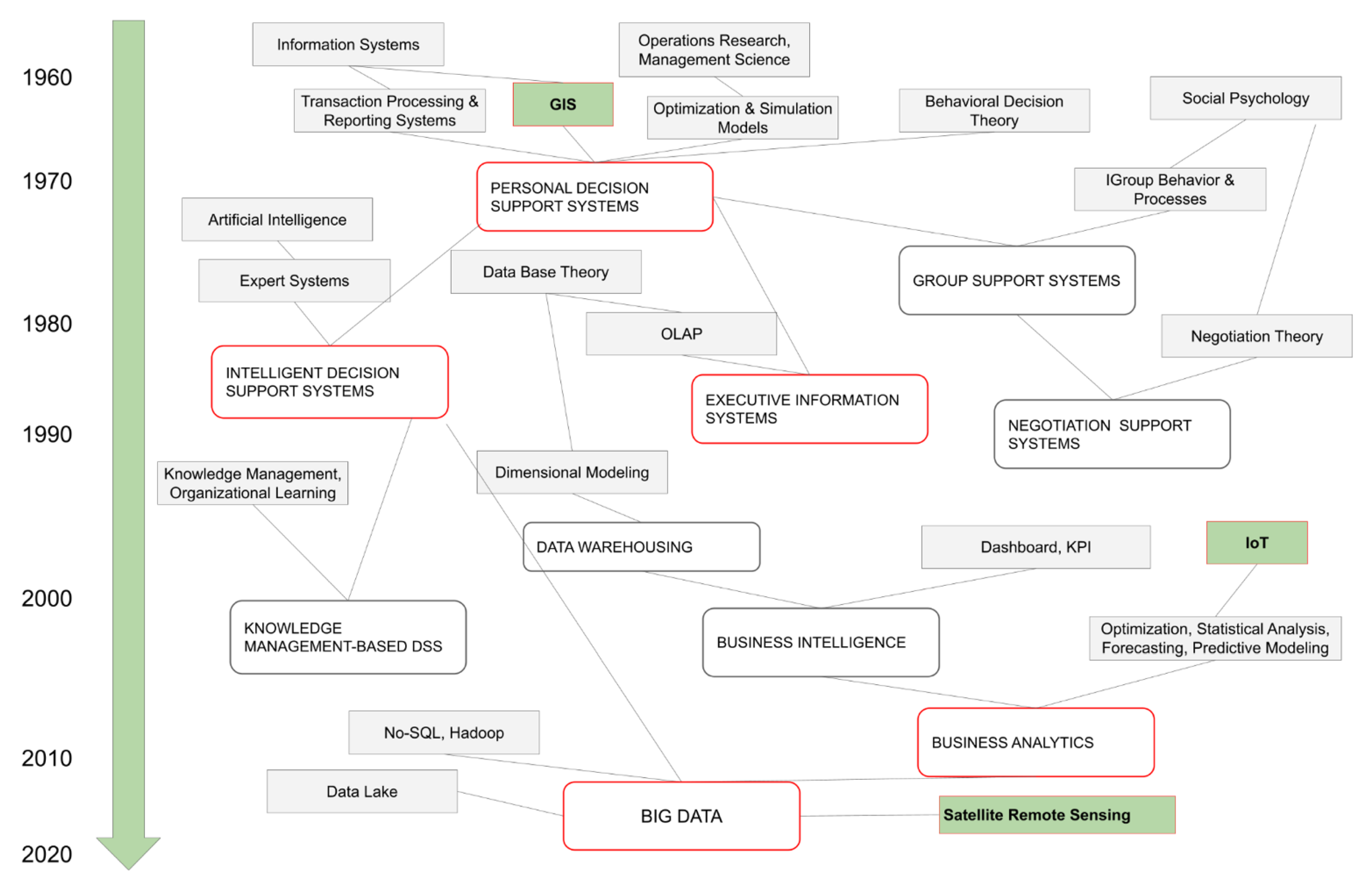
2.1. Decision Support Systems and Wildland Fires
2.2. Challenges for the Use of DSS in Wildland Fires
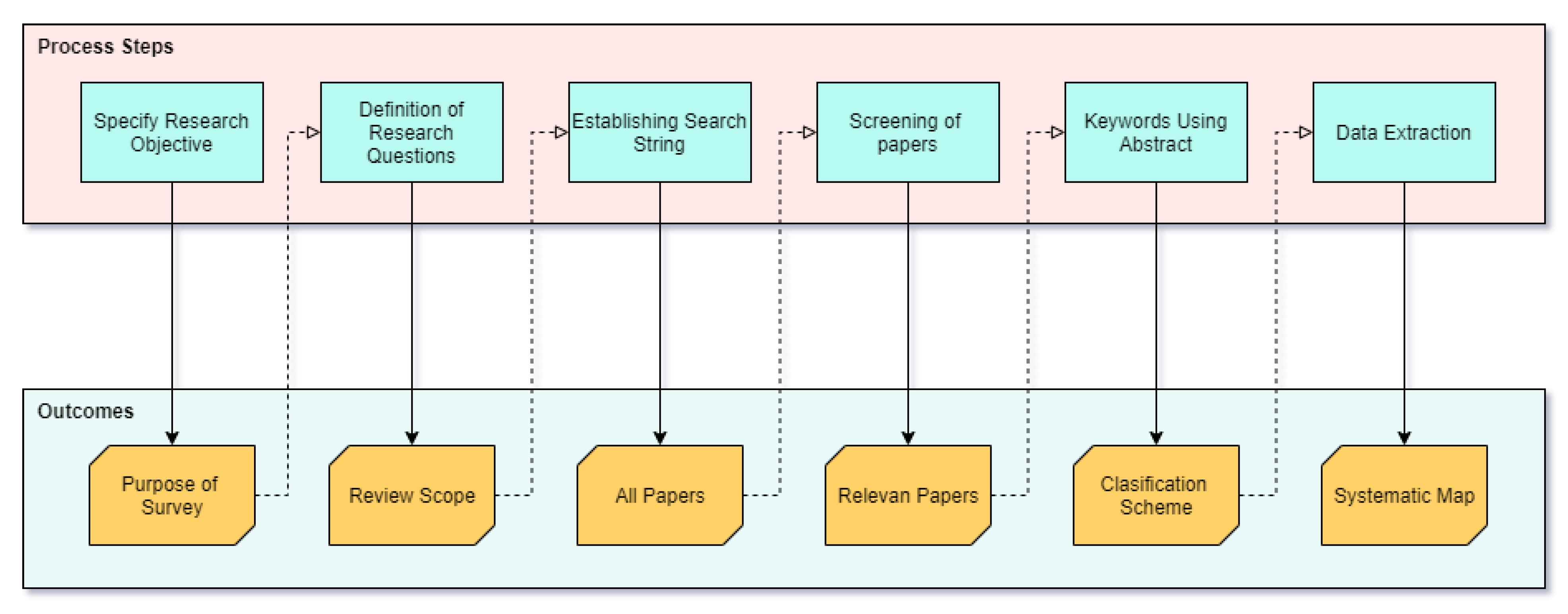
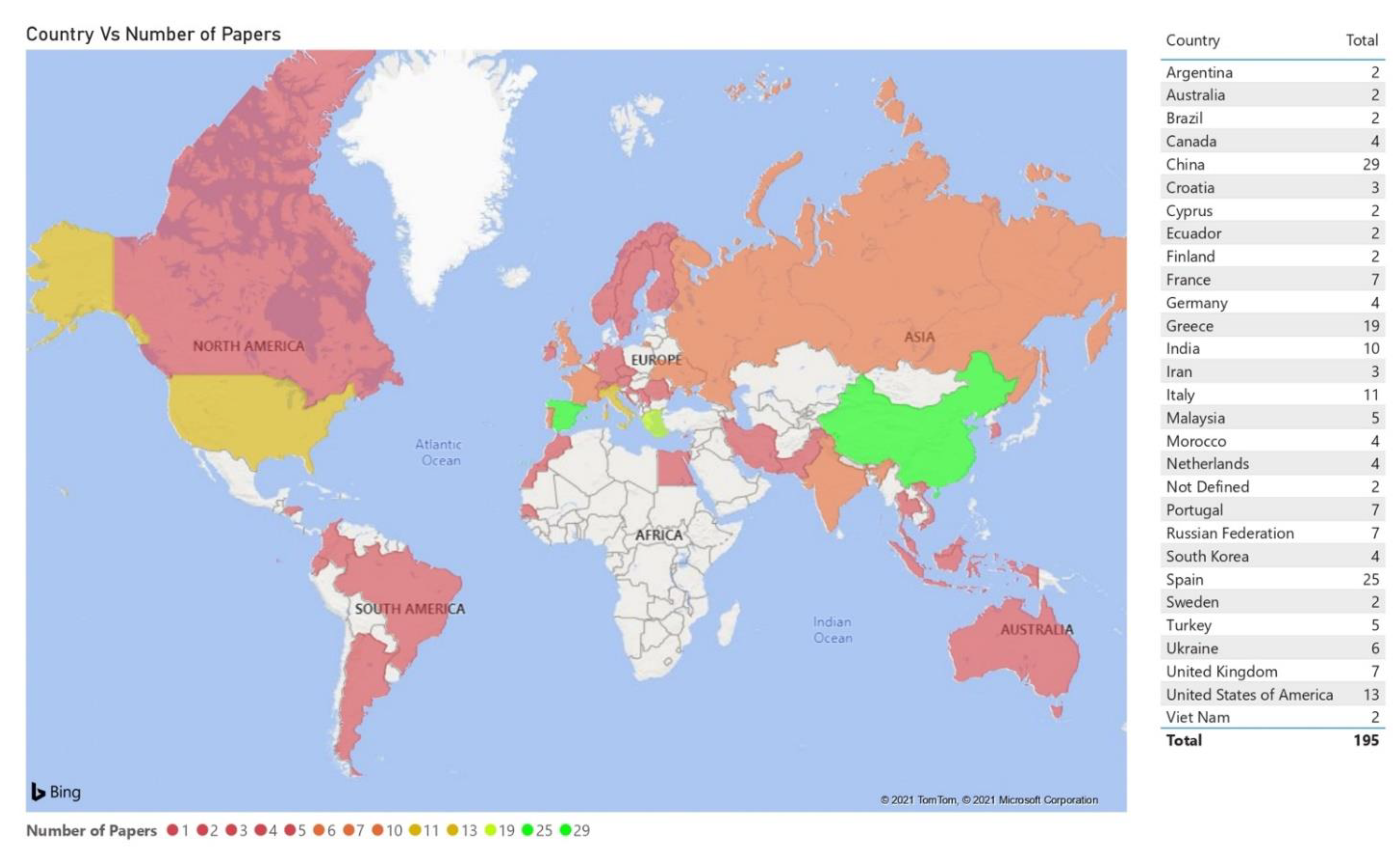
3. Research Methodology
4. Activities Developed in Systematic Mapping
4.1. Research Objectives
- O1.
- Identify the studies that explain the use of DSS in wildland fire management.
- O2.
- Characterize the DSS used in wildland fire management.
- O3.
- Classify the types of DSS used according to the problems encountered in wildland fires.
- O4.
- Identify the technologies used in the DSS for wildland fire support.
- O5.
- Identify the type of research used and the study context.
4.2. Definition of the Research Questions
4.3. Search String
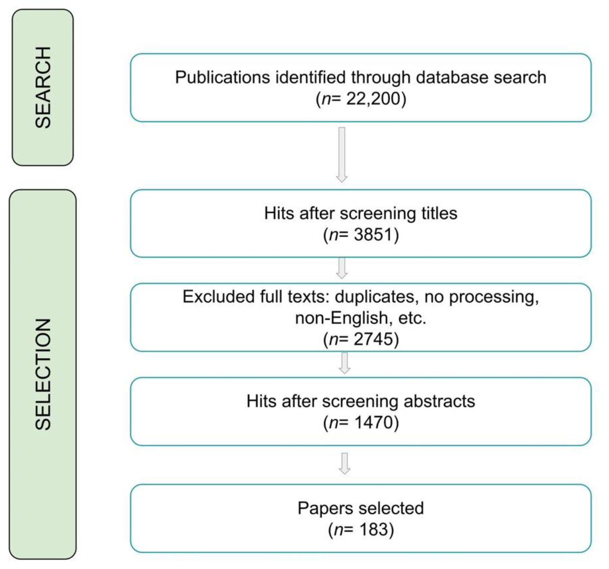
4.4. Screening of Relevant Papers
- Articles not published in the English language.
- Articles published other than conferences, journals, and technical reports.
- Articles published before 2010.
- Articles that did not include the use of DSS for support in wildland fires.
- Incomplete articles or that did not resolve a problem.
- Papers that were not relevant to the search string.
4.5. Keywording Using the Abstract
4.6. Study Selection Process
4.7. Data Extraction Method
- (i)
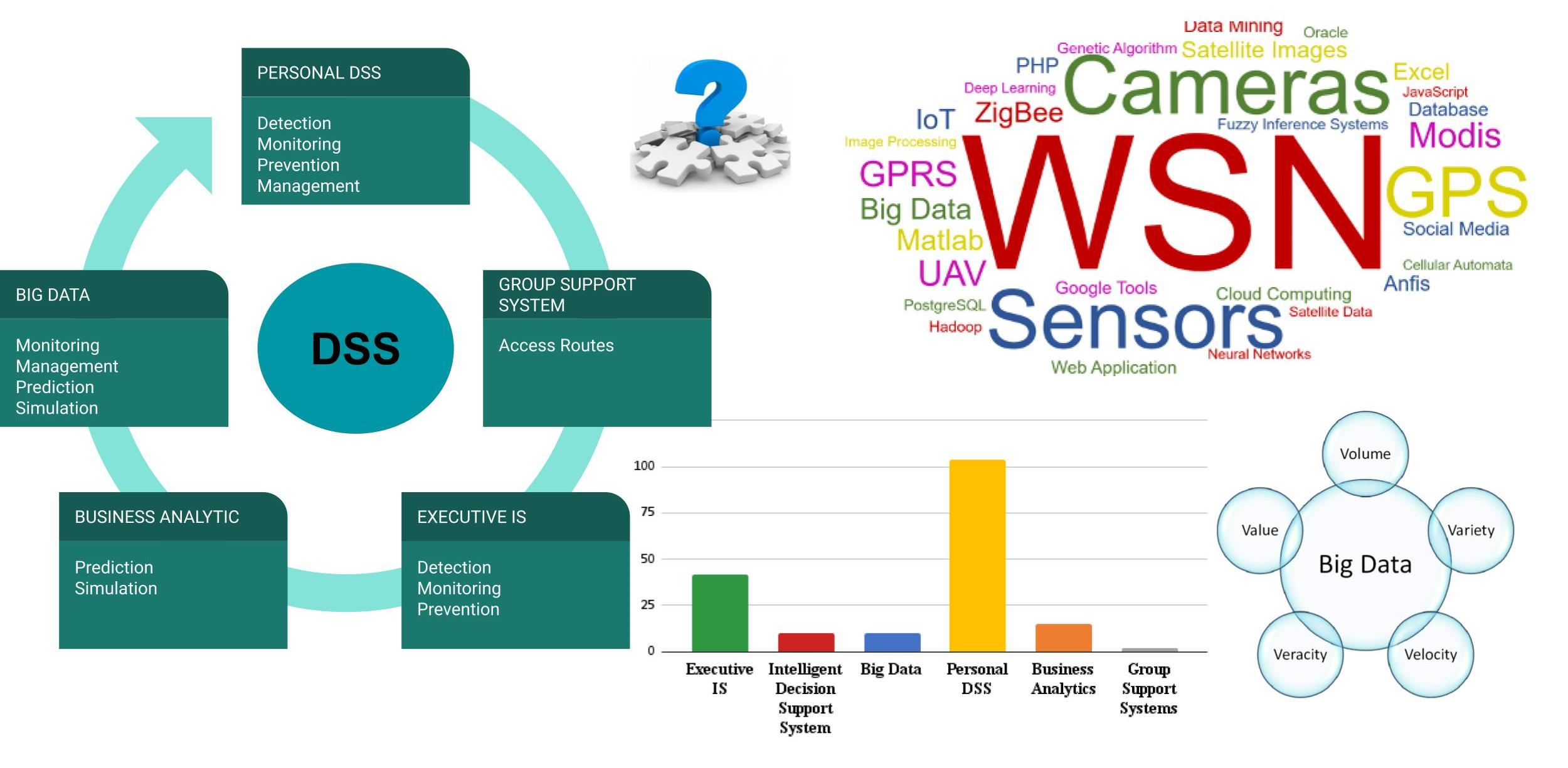
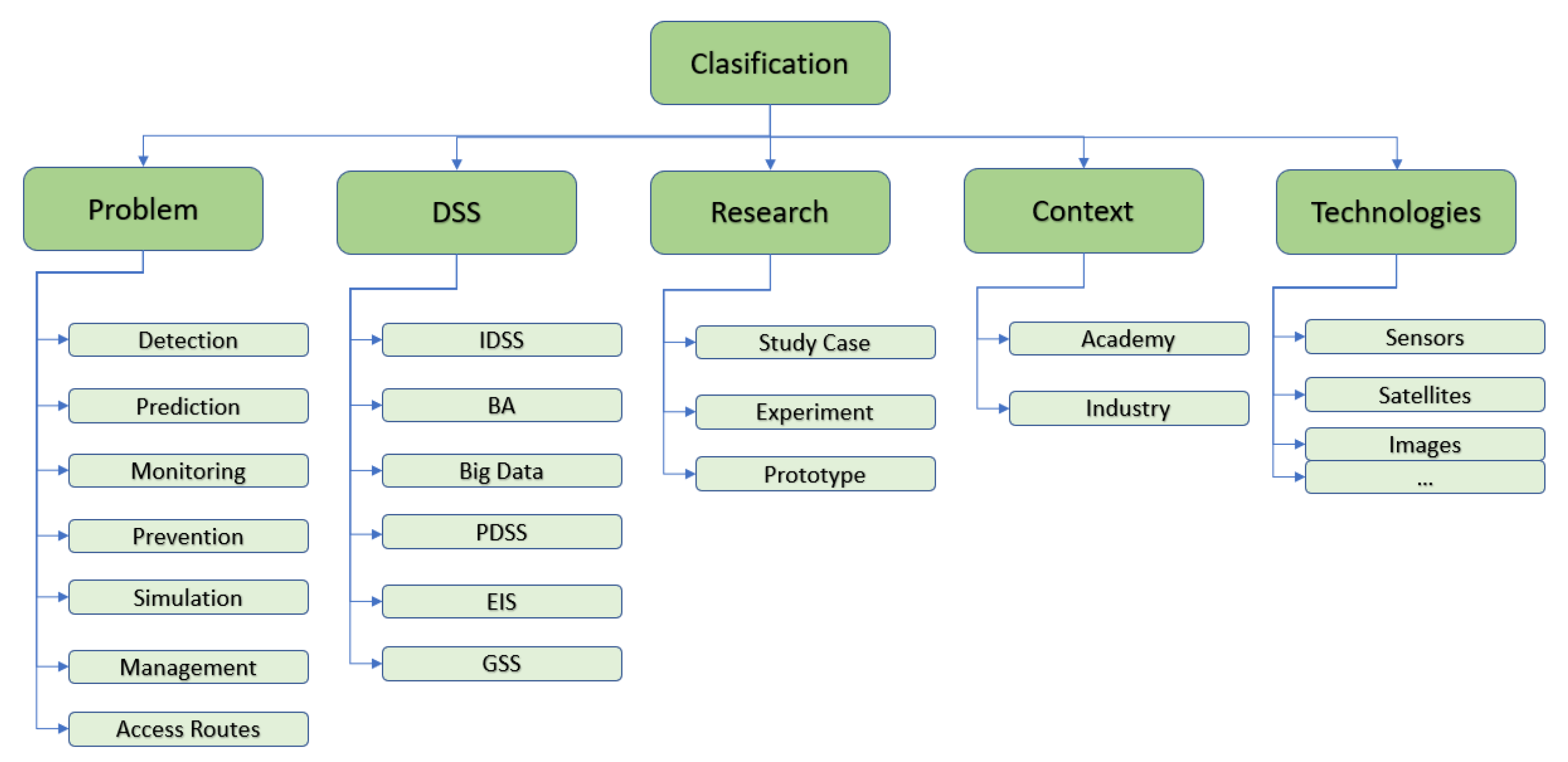
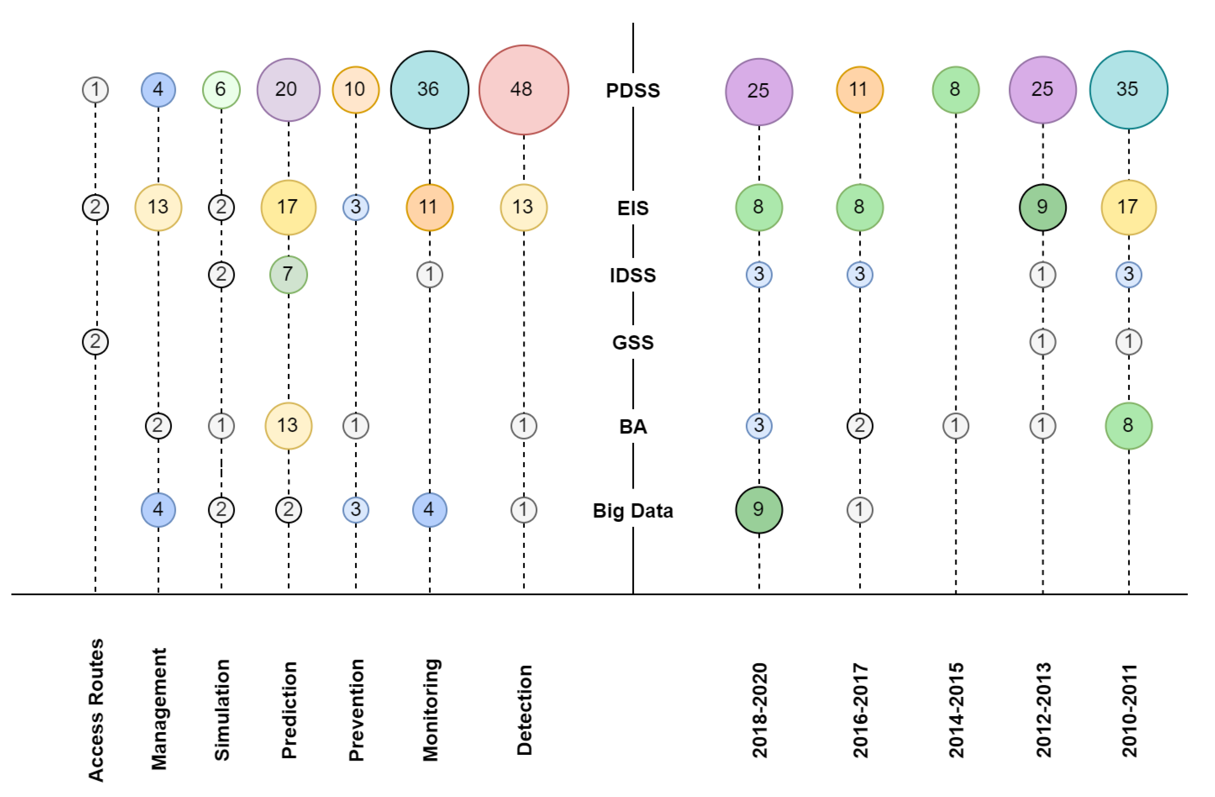
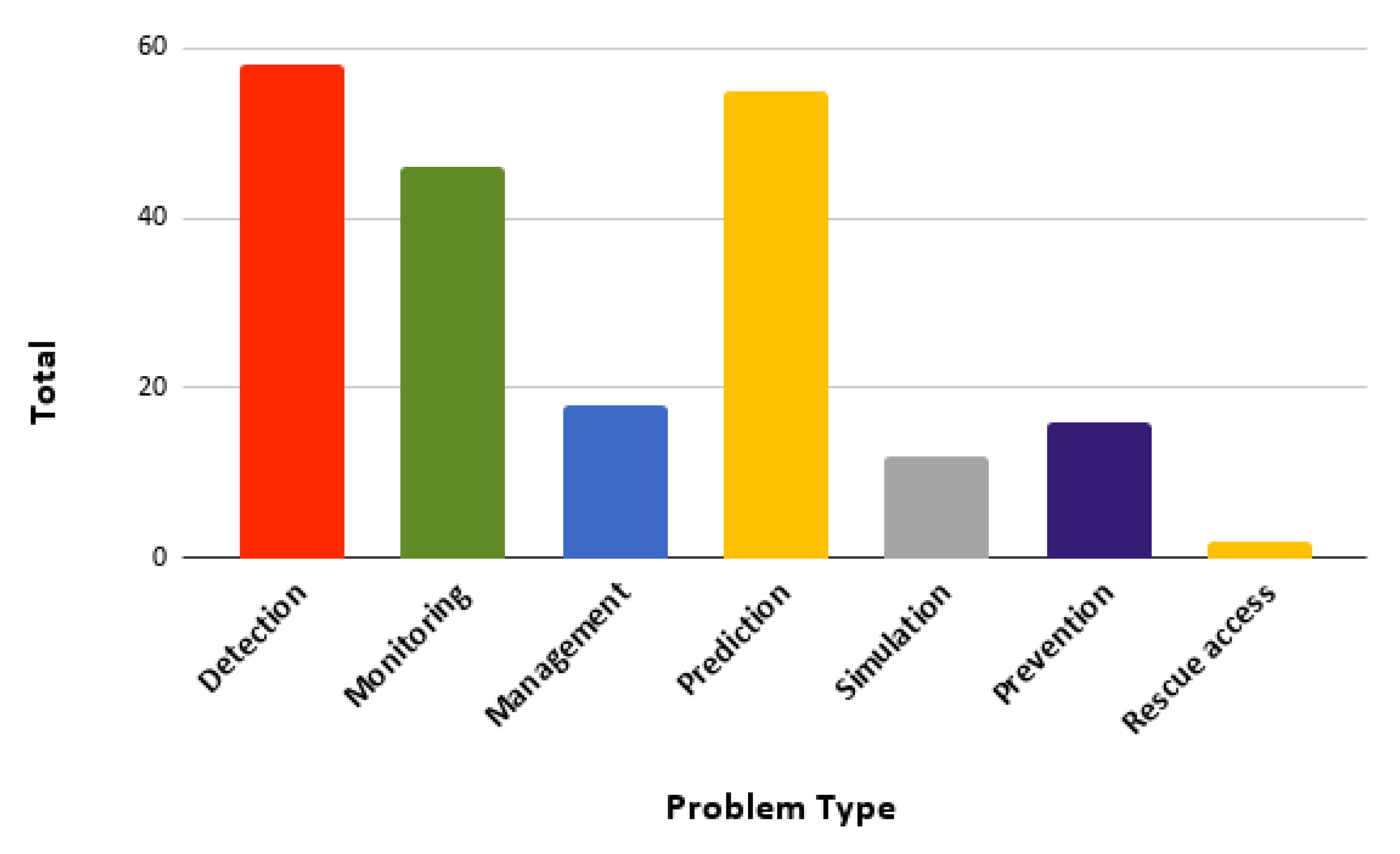
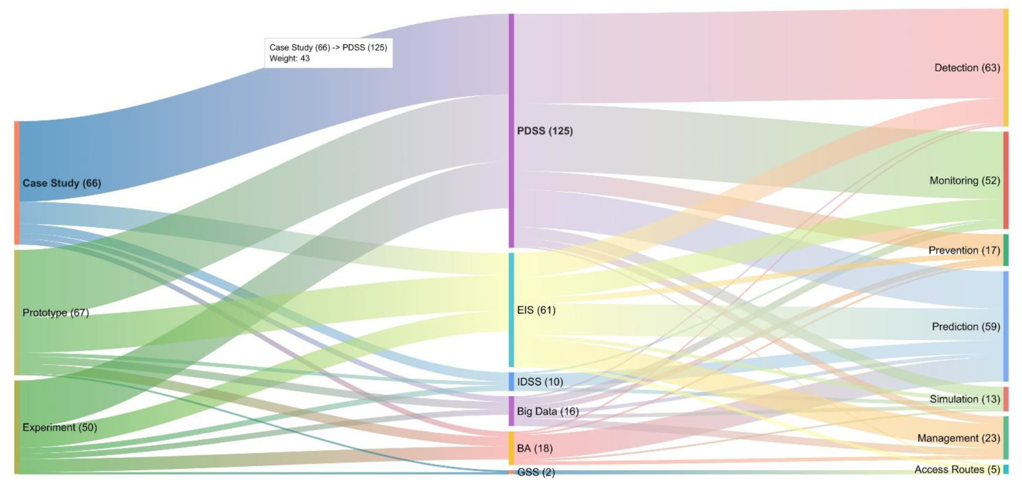
- Types of problems: These are classified according to the problem of wildland fire management that they solve. The most noteworthy problems include the divergence between the beginning of the fire and the detection, which, in this work, will be mentioned as a detection issue. Other types will be the monitoring of sectors with a potential fire hazard, the management of a fire that already is active, the prediction of future fires, the simulation of fire behavior, the prevention of how fires are generated, and the generation of access routes.
- (ii)
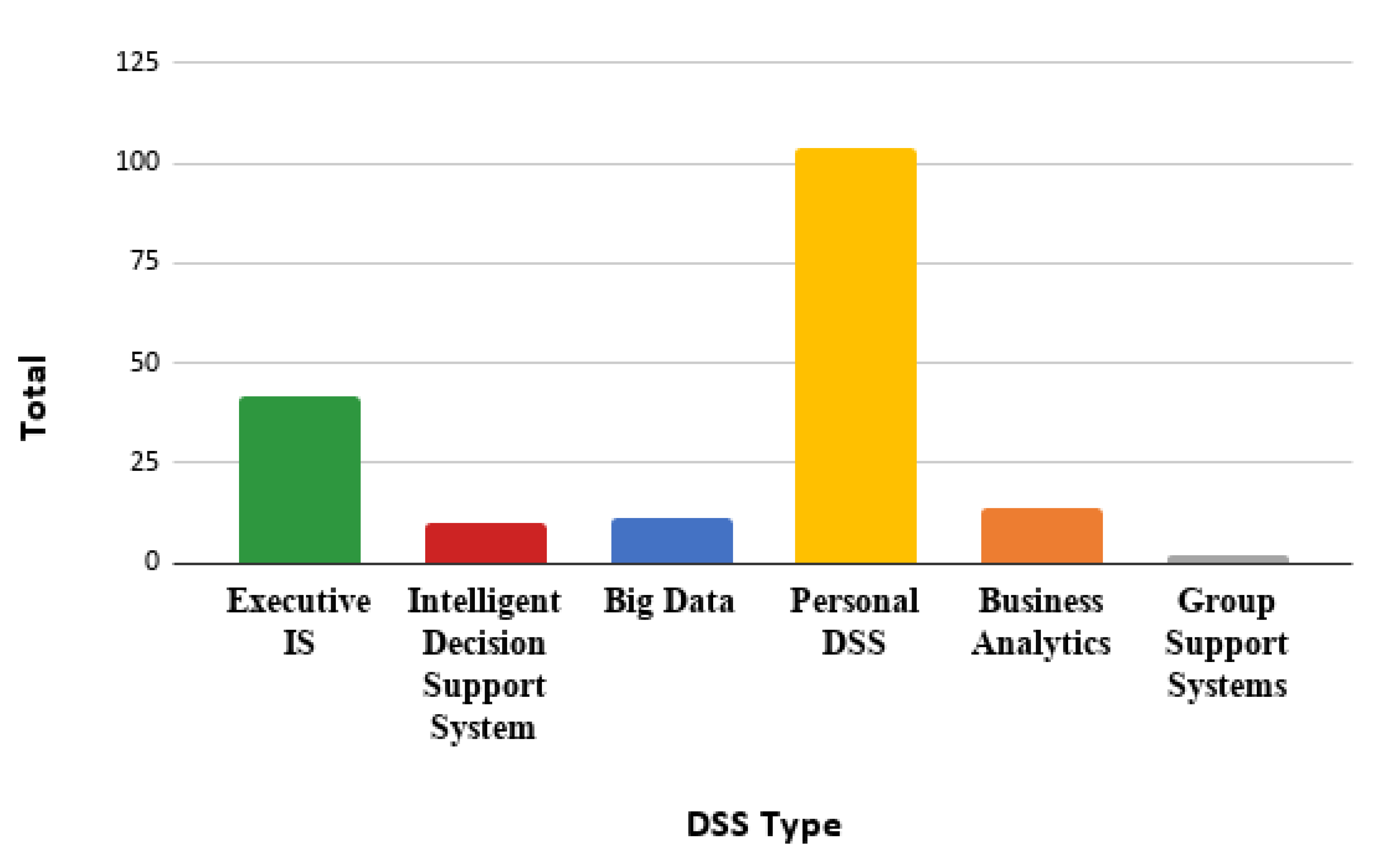
- Types of DSS: These are classified according to the DSS presented in Figure 1. In the area of wildland fires, we found PDSS, IDSS, EIS, GSS, BA, and Big Data.
- (iii)
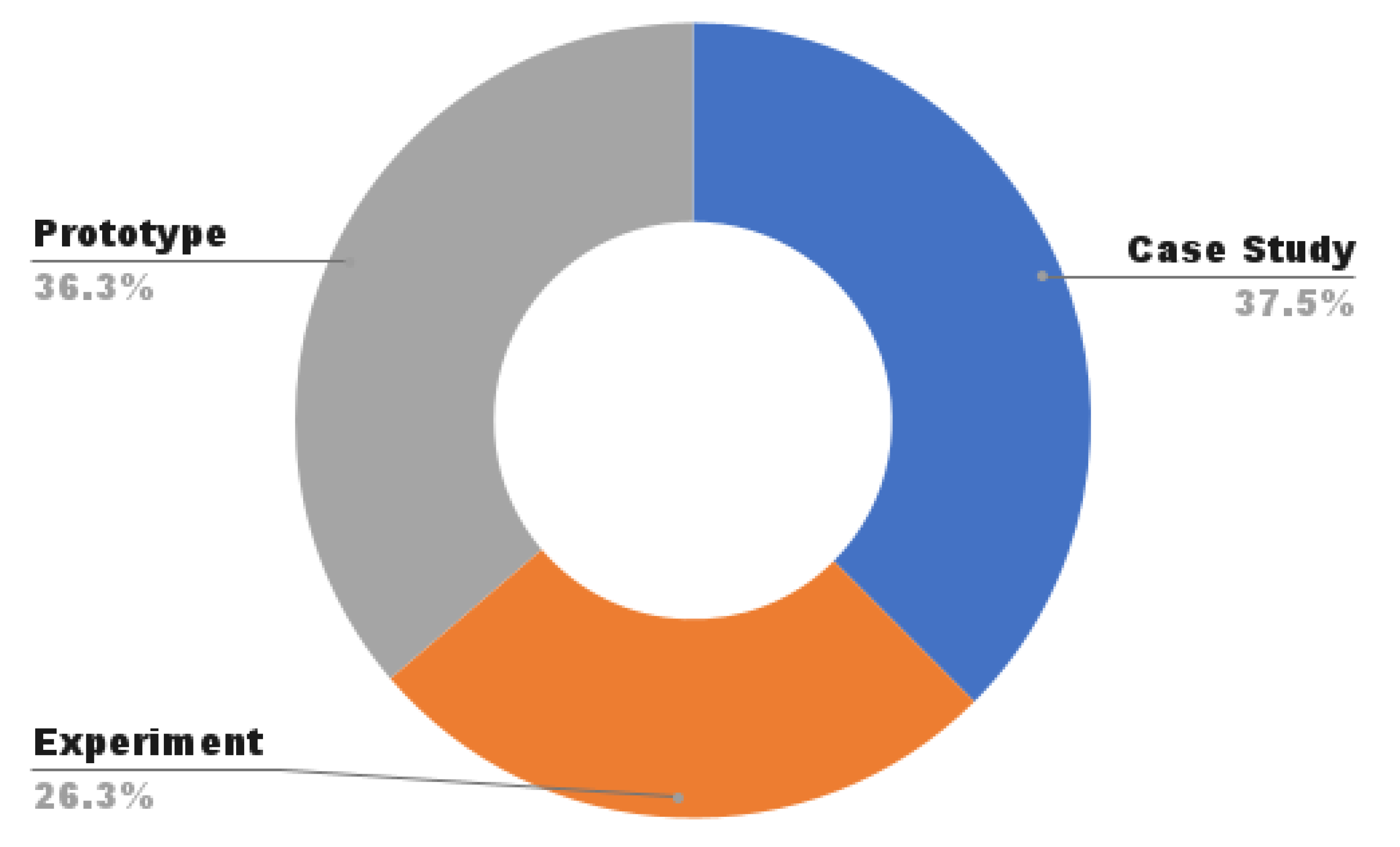
- Types of research: The possible classifications are case study, experiment, or prototype. Case study corresponds to the process of focusing on a single case from a group or defined place; therefore, its results are inherent and exclusive to that group or place. An experiment corresponds to a procedure in which the goal is to make a discovery, prove a hypothesis, or verify a known fact. A prototype is a first product or proof of concept.
- (iv)
- Context in which it is used: This is the developed context of the study, either in academia or industry (real case). The academia context is considered when the work is carried out within a research center, institute, university, or other. The industry context is used when the work was carried out in an organization, company, or business.
- (v)
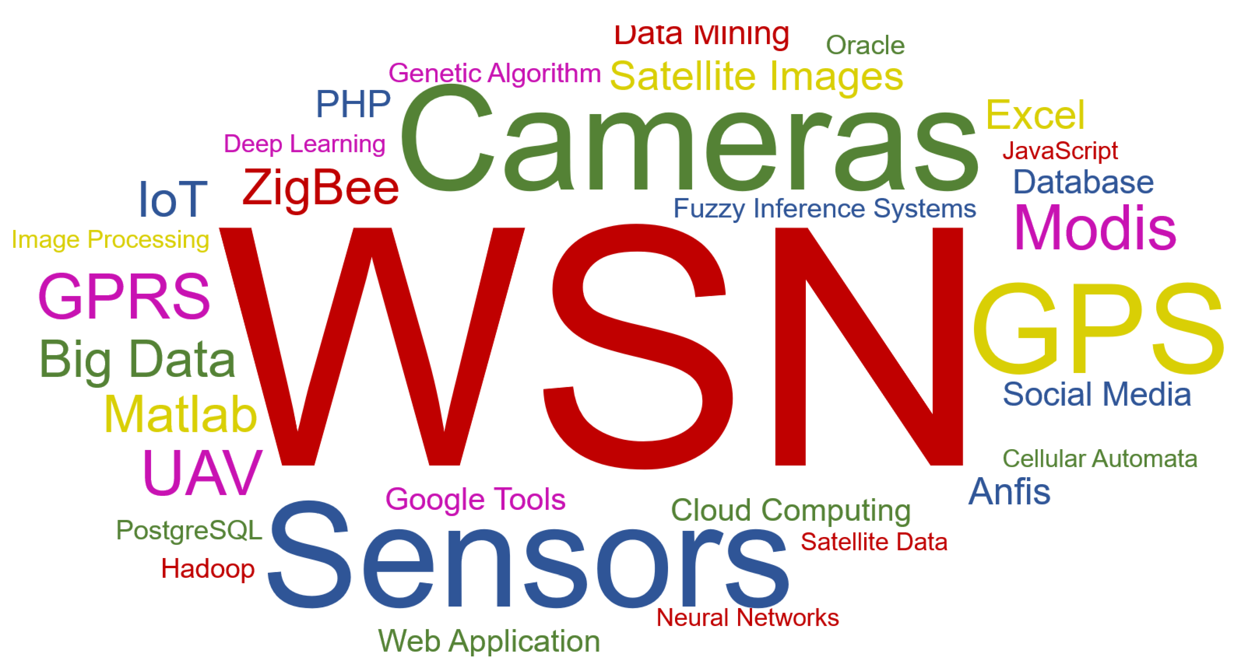
- Technologies used: These are all the technologies mentioned in the studies analyzed. Several technologies were used for the data intake, processing, analysis, and visualization of the results.
4.8. Selection of Results
4.9. Results of Systematic Mapping
4.10. Response to Research Questions (RQ)
5. Discussion
6. Limitations of the Study
6.1. Construct Validity
6.2. Internal Validity
6.3. External Validity
6.4. Conclusion Validity
7. Conclusions
Author Contributions
Funding
Institutional Review Board Statement
Informed Consent Statement
Acknowledgments
Conflicts of Interest
Appendix A

| Reference | Title | Authors | P. Channel | Year | Citations |
|---|---|---|---|---|---|
| [178] | 3D Fire Front Reconstruction in UAV-Based Forest-Fire Monitoring System | Sherstjuk V, Zharikova M, … | IEEEXplore | 2020 | |
| [127] | A Novel Forest Fire Detection System Using Fuzzy Entropy Optimized Thresholding and STN-based CNN | Avula SB, Badri SJ, Reddy G | IEEEXplore | 2020 | |
| [128] | A Retrospective on ASPires: An Advanced System for the Prevention and Early Detection of Forest Fires | Peinl P. | ACM | 2020 | |
| [129] | An IoT-based forest fire detection system | Scicluna, D. | IJET | 2020 | |
| [130] | Architecture of embedded intelligent video analysis system for forest fire prevention | Zhang B., Zhang Z. | IOP | 2020 | |
| [131] | Bee2Fire: A deep learning powered forest fire detection system | de Almeida R.V., Crivellaro F., Narciso M., Sousa A.I., Vieira P. | SciTePress | 2020 | |
| [132] | Design of Forest Fire Warning System Based on Machine Vision | Peng J, Zhang H, Wu H, Wei Q | Springer | 2020 | |
| [189] | Development of an Intelligent System for Predicting the Forest Fire Development Based on Convolutional Neural Networks | Stankevich T.S. | Springer | 2020 | |
| [133] | Early Forest Fire Detection System using Wireless Sensor Network and Deep Learning | Benzekri W, Moussati A El, Moussaoui O, Berrajaa M | IJACSA | 2020 | |
| [134] | Efficient Forest Fire Detection System Based on Data Fusion Applied in Wireless Sensor Networks | Jilbab A, Bourouhou A | IJEEI | 2020 | |
| [135] | Fireanalyst: An effective system for detecting fire geolocation and fire behavior in forests using mathematical modeling | Güllüce Y., Çelik R.N. | TUBITAK | 2020 | |
| [136] | Forest Fire Detection and Alerting System | Minu O, Ramsiya M, Thasini A, Narayanan KV, Arun K | IEEEXplore | 2020 | |
| [137] | FOREST FIRE DETECTION SYSTEM USING IOT | Khan S., Jain S, MN Anusha, YP Kalyan | IJEAST | 2020 | |
| [138] | Forest Fire Detection System using LoRa Technology | Gaitan NC., P Hojbota | IJACSA | 2020 | |
| [139] | IoT-fog enabled framework for forest fire management system | Srividhya S., Sankaranarayanan S. | IEEEXplore | 2020 | |
| [140] | Optimization of Sugeno Fuzzy Logic Based on Wireless Sensor Network in Forest Fire Monitoring System | Budiyanto S., Silalahi LM., FA Silaban, … | IEEEXplore | 2020 | |
| [45] | ‘Portugal Without Fires’, A Data Visualization System to Help Analyze Forest Fire Data in Portugal | Gonçalves D., Lima B., Moura J.M., Ferreira L. | Springer | 2019 | |
| [44] | Fuzzy-Based Forest Fire Prevention and Detection by Wireless Sensor Networks | Toledo-Castro J., Santos-González I., Caballero-Gil P., Hernández-Goya C., Rodríguez-Pérez N., Aguasca-Colomo R. | Springer | 2019 | |
| [143] | Strategic and tactical planning to improve suppression efforts against large forest fires in the Catalonia region of Spain | Gonzalez-Olabarria J.R., Reynolds K.M., Larrañaga A., Garcia-Gonzalo J., Busquets E., Pique M. | ScienceDirect | 2019 | 1 |
| [141] | Mapping combined wildfire and heat stress hazards to improve evidence-based decision making | Vitolo C., Di Napoli C., Di Giuseppe F., Cloke H.L., Pappenberger F. | ScienceDirect | 2019 | |
| [92] | Spatial pattern analysis and prediction of forest fire using new machine learning approach of Multivariate Adaptive Regression Splines and Differential Flower Pollination optimization: A case study at Lao Cai province (Viet Nam) | Tien Bui D., Hoang N.-D., Samui P. | ScienceDirect | 2019 | |
| [173] | Data Mining Approach to Predict Forest Fire Using Fog Computing | Aakash R.S., Nishanth M., Rajageethan R., Rao R., Ezhilarasie R. | IEEEXplore | 2019 | |
| [180] | Scalability of a multi-physics system for forest fire spread prediction in multi-core platforms | Farguell A., Cortés A., Margalef T., Miró J.R., Mercader J. | Springer | 2019 | 1 |
| [2] | Design and development of forest fire monitoring terminal | Wu F., Lv X., Zhang H. | IEEEXplore | 2019 | |
| [43] | Development of forest fire early warning system based on the wireless sensor network in Lawu Mountain. | Yahya Dewangga Z., Koesuma S. | ICOPIA | 2019 | |
| [142] | Detection and monitoring of forest fires using Himawari-8 geostationary satellite data in South Korea | Jang E., Kang Y., Im J., Lee D.-W., Yoon J., Kim S.-K. | MDPI | 2019 | |
| [9] | Adaptive Neuro Fuzzy Inference System (ANFIS) based wildfire risk assessment | Kaur H., Sood S.K. | JETAI | 2019 | |
| [191] | COMBINING SOCIAL MEDIA AND AUTHORITATIVE DATA FOR CRISIS MAPPING: A CASE STUDY OF A WILDFIRE REACHING CROATIAN CITY OF SPLIT. | Tavra M, Racetin I, Peroš J | IAPRSSIS | 2019 | |
| [194] | Predictive modeling of wildfires: A new dataset and machine learning approach | Sayad YO, Mousannif H, Al Moatassime H | ScienceDirect | 2019 | |
| [195] | Studies on Big Data Mining Techniques in Wildfire Prevention for Power System | Zhou T, Li B, Wu C, Tan Y, Mao L, … | IEEEXplore | 2019 | |
| [144] | Prediction and management system for forest fires based on hybrid flower pollination optimization algorithm and adaptive neuro-fuzzy inference system | Ahmed K., Ewees A.A., Hassanien A.E. | IEEEXplore | 2018 | 1 |
| [174] | GIS-based spatial prediction of tropical forest fire danger using a new hybrid machine learning method | Tien Bui D., Le H.V., Hoang N.-D. | ScienceDirect | 2018 | 3 |
| [47] | Implementation of Information Technologies in the Organization of Forest Fire Suppression Process | Smotr O., Borzov Y., Burak N., Ljaskovska S. | IEEEXplore | 2018 | |
| [181] | A fuzzy inference and big data analysis algorithm for the prediction of forest fire based on rechargeable wireless sensor networks | Lin H., Liu X., Wang X., Liu Y. | ScienceDirect | 2018 | 3 |
| [145] | Coupling early warning services, crowdsourcing, and modelling for improved decision support and wildfire emergency management | Bielski C., O’Brien V., Whitmore C., Ylinen K., Juga I., Nurmi P., Kilpinen J., Porras I., Sole J.M., Gamez P., Navarro M., Alikadic A., Gobbi A., Furlanello C., Zeug G., Weirather M., Martinez J., Yuste R., Castro S., Moreno V., Velin T., Rossi C. | IEEEXplore | 2018 | 1 |
| [46] | An intelligent wireless system for field ecology monitoring and forest fire warning | Zheng Y., Zhao Y., Liu W., Liu S., Yao R. | MDPI | 2018 | |
| [94] | An INSPIRE-compliant open-source GIS for fire-fighting management | Grasso N., Lingua A.M., Musci M.A., Noardo F., Piras M. | Springer | 2018 | 1 |
| [93] | Forest Fire Monitoring System Based on UAV Team, Remote Sensing, and Image Processing | Sherstjuk V., Zharikova M., Sokol I. | IEEEXplore | 2018 | |
| [48] | Advancing early forest fire detection utilizing smart wireless sensor networks | Pokhrel P., Soliman H. | Springer | 2018 | |
| [190] | The emergence of social media for natural disasters management: a big data perspective | Athanasis N, Themistocleous M, Kalabokidis K, … | MDPI | 2018 | |
| [192] | An application framework for forest fire and haze detection with data acquisition using unmanned aerial vehicle | Saadat M.N., Husen M.N. | ACM | 2018 | |
| [193] | Big data analysis in UAV surveillance for wildfire prevention and management | Athanasis N, Themistocleous M, Kalabokidis K, … | Springer | 2018 | |
| [146] | An integrated approach for tactical monitoring and data-driven spread forecasting of wildfires | Valero M.M., Rios O., Mata C., Pastor E., Planas E. | ScienceDirect | 2017 | 4 |
| [49] | Forest fire information system using wireless sensor network | Devadevan V., Sankaranarayanan S. | ScienceDirect | 2017 | 1 |
| [8] | Situation awareness in the large forest fires response. A solution based on wireless mesh networks | Zambrano M., Esteve M., Pérez I., Carvajal F., Zambrano A.M. | IEEEXplore | 2017 | |
| [50] | Design and implementation of a Wireless Sensor Network to detect forest fires | Granda Cantuña J., Bastidas D., Solórzano S., Clairand J.-M. | IEEEXplore | 2017 | 5 |
| [147] | Forest fire monitoring system based on aerial image | Kim S., Lee W., Park Y.-S., Lee H.-W., Lee Y.-T. | IEEEXplore | 2017 | 5 |
| [148] | Sensor data monitoring and decision level fusion scheme for early fire detection | Rizogiannis C., Thanos K.G., Astyakopoulos A., Kyriazanos D.M., Thomopoulos S.C.A. | SPIE | 2017 | |
| [29] | Wildfire prevention in the era of big data | Athanasis N, Themistocleous M, … | Springer | 2017 | |
| [175] | Decentralized estimation of forest fire spread using mobile sensors | Schlotterbeck G., Raïevsky C., Lefèvre L. | Springer | 2016 | 2 |
| [150] | Forest fire modelling using cellular automata: application to the watershed Oued Laou (Morocco) | Jellouli O., Bernoussi A., Mâatouk M., Amharref M. | MCMDS | 2016 | 4 |
| [52] | The Greek national observatory of forest fires (NOFFi) | Tompoulidou M., Stefanidou A., Grigoriadis D., Dragozi E., Stavrakoudis D., Gitas I.Z. | SPIE | 2016 | 3 |
| [172] | A web based DSS for the management of floods and wildfires (FLIRE) in urban and periurban areas | Kochilakis G., Poursanidis D., Chrysoulakis N., Varella V., Kotroni V., Eftychidis G., Lagouvardos K., Papathanasiou C., Karavokyros G., Aivazoglou M., Makropoulos C., Mimikou M. | ScienceDirect | 2016 | 4 |
| [95] | Focused sunlight factor of forest fire danger assessment using Web-GIS and RS technologies | Baranovskiy N.V., Sherstnyov V.S., Yankovich E.P., Engel M.V., Belov V.V. | Elsevier | 2016 | 1 |
| [149] | FLIRE DSS: A web tool for the management of floods and wildfires in urban and periurban areas | Kochilakis G., Poursanidis D., Chrysoulakis N., Varella V., Kotroni V., Eftychidis G., Lagouvardos K., Papathanasiou C., Karavokyros G., Aivazoglou M., Makropoulos C., Mimikou M. | OP | 2016 | 1 |
| [96] | GWR-PM—Spatial variation relationship analysis with Geographically Weighted Regression (GWR)—An application at Peninsular Malaysia | Jamhuri J., Azhar B.M.S., Puan C.L., Norizah K. | IOP | 2016 | 1 |
| [98] | Web-GIS platform for forest fire danger prediction in Ukraine: Prospects of RS technologies | Baranovskiy N.V., Zharikova M.V. | SPIE | 2016 | 1 |
| [99] | Joint processing of RS and WWLLN data for forest fire danger estimation: New concept | Baranovskiy N.V., Krechetova S.Y., Belikova M.Y., Kocheeva N.A., Yankovich E.P. | SPIE | 2016 | 2 |
| [151] | An open service platform for multi-hazard in action—The PHAROS pilot demonstration | Barth B., Marchitti M.A., Mulero Chaves J., Raape U., Strobl C., Borràs M., Vilalta O., Ballart H., Vendrell J., Prat N., Mendes M., Ladoire T., Gardikis G., Pantazis S., Costicoglou S., Jäckel K., Van Setten W. | LNI | 2016 | |
| [51] | Forest environment monitoring application of intelligence embedded based on wireless sensor networks | Seo J.H., Park H.B. | KSII | 2016 | 2 |
| [97] | Forest Fire Warning System Based on GIS and WSNs | Wang M., Liu H., Chen F., Liu J. | IEEEXplore | 2016 | 2 |
| [42] | Data mining techniques applied to wireless sensor networks for early forest fire detection | Saoudi M., Bounceur A., Euler R., Kechadi T. | ACM | 2016 | 5 |
| [100] | PREFER: A European service providing forest fire management support products | Eftychidis G., Laneve G., Ferrucci F., Sebastian Lopez A., Lourenco L., Clandillon S., Tampellini L., Hirn B., Diagourtas D., Leventakis G. | SPIE | 2015 | 1 |
| [53] | Geoinformation monitoring of forest fire danger on the basis of remote sensing data of surface by the artificial earth satellite | Baranovskiy N.V., Yankovich E.P. | Elsevier | 2015 | 12 |
| [54] | Research and application of fire risk assessment based on satellite remote sensing for transmission line | Chen X., Li T., Ruan L., Xu K., Huang J., Xiong Y. | SemanticScholar | 2015 | 1 |
| [182] | Wildfire evacuation trigger buffers for sensitive areas: EVITA project | Kiranoudis C.T., Zachariadis E., Keramitsoglou I., Saini K., Kakaliagou O., Kleitsikas E. | IEEEXplore | 2014 | |
| [55] | Fuzzy logic based implementation for forest fire detection using wireless sensor network | Dutta M., Bhowmik S., Giri C. | Springer | 2014 | 5 |
| [103] | A web-oriented geoinformation system application for forest fire danger prediction in typical forests of the Ukraine | Baranovskiy N., Zharikova M. | Springer | 2014 | 13 |
| [101] | Mapping and analysis of forest and land fire potential using geospatial technology and mathematical modeling | Suliman M.D.H., Mahmud M., Reba M.N.M., S L.W. | IOP | 2014 | |
| [102] | ArcGIS for assessment and display of the probability of forest fire danger | Yankovich E.P., Baranovskiy N.V., Yankovich K.S. | IEEEXplore | 2014 | 9 |
| [56] | Firoxio: Forest fire detection and alerting system | Owayjan M., Freiha G., Achkar R., Abdo E., Mallah S. | IEEEXplore | 2014 | 7 |
| [105] | The research on forest fire simulation system | Huang Z., He S., Qiu L. | IEEEXplore | 2013 | |
| [59] | Forest fire detection in wireless sensor network using fuzzy logic | Bolourchi P., Uysal S. | IEEEXplore | 2013 | 22 |
| [60] | A tool for simulation and geo-animation of wildfires with fuel editing and hotspot monitoring capabilities | Bogdos N., Manolakos E.S. | ScienceDirect | 2013 | 13 |
| [109] | Modeling the spread of spatio-temporal phenomena through the incorporation of ANFIS and genetically controlled cellular automata: A case study on forest fire | Vahidnia M.H., Alesheikh A.A., Behzadi S., Salehi S. | IJDE | 2013 | 4 |
| [111] | A gis based assistant information system for forest fire prevention direction | Yu X., Zhang W., Yang Y., Lei Z., Zhang X. | Scientific.net | 2013 | 2 |
| [108] | The zoning of forest fire potential of Gulestan province forests using granular computing and MODIS images | Shadlouei A.J., Delavar M.R. | IAPRSSIS | 2013 | |
| [179] | A data-driven model for large wildfire behaviour prediction in Europe | Rodriguez-Aseretto D., De Rigo D., Di Leo M., Cortés A., San-Miguel-ayanz J. | ScienceDirect | 2013 | 17 |
| [104] | Design & application of forest fire monitoring system by remote sensing for Beijing, Tianjin & Hebei | Zhao C.L., Hou X. | MDPI | 2013 | |
| [57] | Design of optical electronic watch system based on multi-sensor | Wu C., Lu J.F., He B.G. | AMR | 2013 | |
| [58] | Design and function of the European forest fire information system | McInerney D., San-Miguel-Ayanz J., Corti P., Whitmore C., Giovando C., Camia A. | PERS | 2013 | 3 |
| [107] | Design and realization of forest fire monitoring system based on GIS in Henan Province, China | Liu X., Geng Y., He Z., Zhang J., Zhang L., Chen Z., Li D. | Scientific.net | 2013 | 1 |
| [199] | Forest fire detection system based on zigbee wireless sensor network | Zhu Y.L., Xie L.Q. | Scientific.net | 2013 | 1 |
| [62] | Wireless sensor network for forest fire detection | Hariyawan M.Y., Gunawan A., Putra E.H. | ScienceDirect | 2013 | 17 |
| [67] | Managing forest fires with i-protect fire simulation module | Filippopoulos I., Stamoulis G., Kikiras P. | IEEEXplore | 2012 | |
| [152] | Simulation and visualization of forest fire growth in an integrated 3D virtual geographical environment—A preliminary study | Huang H., Tang L., Li J., Chen C. | IEEEXplore | 2012 | 4 |
| [112] | Introducing GIS-based simulation tools to support rapid response in wildland fire fighting | Moreno A., Segura A., Zlatanova S., Posada J., García-Alonso A. | WITPRESS | 2012 | 2 |
| [111] | A GIS-based decision support system for determining the shortest and safest route to forest fires: A case study in Mediterranean Region of Turkey | Akay A.E., Wing M.G., Sivrikaya F., Sakar D. | Springer | 2012 | 23 |
| [65] | Forest fire hazard modeling using hybrid AHP and fuzzy AHP methods using MODIS sensor | Sharifi Hashjin S., Hoseinpoor Milaghardan A., Esmaeily A., Mojaradi B., Naseri F. | IEEEXplore | 2012 | 3 |
| [154] | Decision support system for forest fire protection in the Euro-Mediterranean region | Kalabokidis K., Xanthopoulos G., Moore P., Caballero D., Kallos G., Llorens J., Roussou O., Vasilakos C. | Springer | 2012 | 16 |
| [155] | PiroPinus: A spreadsheet application to guide prescribed burning operations in maritime pine forest | Fernandes P.M., Loureiro C., Botelho H. | ScienceDirect | 2012 | 14 |
| [183] | Dynamic Data-Driven Genetic Algorithm for forest fire spread prediction | Denham M., Wendt K., Bianchini G., Cortés A., Margalef T. | ScienceDirect | 2012 | 30 |
| [153] | Evaluating fuel complexes for fire hazard mitigation planning in the southeastern United States | Andreu A.G., Shea D., Parresol B.R., Ottmar R.D. | ScienceDirect | 2012 | 12 |
| [64] | Monitoring system for forest fire based on wireless sensor network | Zhu Y., Xie L., Yuan T. | IEEEXplore | 2012 | 9 |
| [71] | A mobility constraint model to infer sensor behaviour in forest fire risk monitoring | Ballari D., Wachowicz M., Bregt A.K., Manso-Callejo M. | ScienceDirect | 2012 | 8 |
| [156] | SIRIO: An integrated forest fire monitoring, detection and decision support system—performance and results of the installation in Sanremo (Italy) | Losso A., Corgnati L., Bertoldo S., Allegretti M., Notarpietro R., Perona G. | WITPRESS | 2012 | 5 |
| [157] | Monitoring network-based infrastructure for forest fire detection | Kharchenko V.S., Orekhov A.A., Kotchkar D.A., Bogomolov V.V. | WITPRESS | 2012 | |
| [72] | A wireless multi-sensor network deployment framework for wildland fire detection | Xiao D., Jiang X., Feng J., Hu Y. | ASABE | 2012 | |
| [70] | Intelligent forest fire monitoring system | Stula M., Krstinic D., Seric L. | Springer | 2012 | 11 |
| [63] | A new thermally activated battery cell-based forest fire detection and monitoring system | Neubauer B., Sidén J., Olofsson C., Gulliksson M., Koptyug A., Nilsson H.-E., Norgren M. | Elsevier | 2012 | 1 |
| [66] | Assessment of sparse forest and fire detection using threshold watershed algorithm | Menaka E., Suresh Kumar S., Parameshwari P. | IEEEXplore | 2012 | |
| [68] | Vision-based fire detection algorithm using optical flow | Ha C., Hwang U., Jeon G., Cho J., Jeong J. | IEEEXplore | 2012 | 16 |
| [69] | FireWatch: G.I.S.-assisted wireless sensor networks for forest fires | Andreou P.G., Constantinou G., Zeinalipour-Yazti D., Samaras G. | Springer | 2012 | 1 |
| [110] | Cluster recognition in spatial-temporal sequences: The case of forest fires | Vega Orozco C., Tonini M., Conedera M., Kanveski M. | Springer | 2012 | 18 |
| [158] | Assistant decision-making support system of forest grass fire based on GIS | Yanping J., Hongye Y., Yuefeng Z., Shuo W. | IEEEXplore | 2011 | 2 |
| [113] | Risk assessment for effective prevention and management of forest fires in Lijiang City | Zheng S., Li C., Su X., Qiu Q., Shao G. | SemanticScholar | 2011 | 3 |
| [75] | Study on forest fires recognition and moving target tracking in video surveillance system | Xiong X.-Y., Wang B. | IEEEXplore | 2011 | 1 |
| [160] | A data fusion framework with novel hybrid algorithm for multi-agent Decision Support System for Forest Fire | Elmas Ç., Sönmez Y. | ScienceDirect | 2011 | 16 |
| [117] | Regional forest-fire susceptibility analysis in central Portugal using a probabilistic ratings procedure and artificial neural network weights assignment | Dimuccio L.A., Ferreira R., Cunha L., Campar De Almeida A. | CSIRO | 2011 | 4 |
| [114] | Satellite data for detecting trans-boundary crop and forest fire dynamics in Northern Thailand | Bach N., simongkalcrtkal N. | SemanticScholar | 2011 | 1 |
| [73] | Fuzzy modeling of the climate change effect to drought and to wild fires in Cyprus | Papakonstantinou X., Iliadis L.S., Pimenidis E., Maris F. | Springer | 2011 | 1 |
| [184] | Machine learning and dataming algorithms for predicting accidental small forest fires | Iyer V., Iyengar S.S., Paramesh N., Murthy G.R., Srinivas M.B. | SemanticScholar | 2011 | 6 |
| [74] | Estimation of area burned by forest fires in Mediterranean countries: A remote sensing data mining perspective | Quintano C., Fernández-Manso A., Stein A., Bijker W. | ScienceDirect | 2011 | 18 |
| [76] | Discovery and integration of web 2.0 content into geospatial information infrastructures: A use case in wild fire monitoring | Núñez-Redó M., Díaz L., Gil J., González D., Huerta J. | Springer | 2011 | 8 |
| [118] | Automatic forest-fire measuring using ground stations and unmanned aerial systems | de Dios J.R.M., Merino L., Caballero F., Ollero A. | MDPI | 2011 | 40 |
| [161] | A real-time Risk Assessment tool supporting wildland fire decisionmaking | Calkin D.E., Thompson M.P., Finney M.A., Hyde K.D. | JOF | 2011 | 62 |
| [162] | Development of a decision support system for the study of an area after the occurrence of forest fire | Ioannou K., Lefakis P., Arabatzis G. | Inderscience | 2011 | 9 |
| [164] | On the use of stereovision to develop a novel instrumentation system to extract geometric fire fronts characteristics | Rossi L., Akhloufi M., Tison Y. | ScienceDirect | 2011 | 33 |
| [116] | Embedded forest fire monitoring and positioning system based on machine vision | Liu L., Shen M., Zhao X., Sun Y., Lu M., Xiong Y. | IEEEXplore | 2011 | 1 |
| [78] | A ground system for early forest fire detection based on infrared signal processing | Bosch I., Gómez S., Vergara L. | SemanticScholar | 2011 | 3 |
| [119] | Foogle: Fire monitoring tool for EUMETSAT’s active fire product over Turkey using Google Earth | Sönmez I., Erdi E., Tekeli A.E., Demir F., Arslan M. | GNHR | 2011 | 3 |
| [115] | Intelligent GIS system of forest fire alarm and it’s controlling strategy design | Duan Y.X., Cao J.Z., Luo Z.L. | IEEEXplore | 2011 | 1 |
| [159] | An effective technique to detect forest fire region through ANFIS with spatial data | Angayarkkani K., Radhakrishnan N. | IEEEXplore | 2011 | 3 |
| [77] | Research of an automatic forest fire detection system based on cooperative perception | Dong Z., Huang D.-G., Zhang D.-Y. | SemanticScholar | 2011 | 1 |
| [163] | Microwave radiometry imaging for forest fire detection: A simulation study | Bonafoni S., Alimenti F., Angelucci G., Tasselli G. | MDPI | 2011 | 15 |
| [120] | Modelling the probability of lightning-induced forest fire occurrence in the province of León (NW Spain) [Modelización de la probabilidad de ocurrencia de incendios forestales por rayo en la provincia de León (NO de España)] | Castedo-Dorado F., Rodriguez-Perez J.R., Marcos-Menendez J.L., Alvarez-Taboada M.F. | Unirioja | 2011 | 3 |
| [79] | Fire risk assessment in the Brazilian Amazon using MODIS imagery and change vector analysis | Maeda E.E., Arcoverde G.F.B., Pellikka P.K.E., Shimabukuro Y.E. | ScienceDirect | 2011 | 13 |
| [171] | Multisource data integration for fire risk management: The local test of a global approach | Diagne M., Drame M., Ferrão C., Marchetti P.G., Pinto S., Rivolta G. | IEEEXplore | 2010 | 8 |
| [165] | Forest fire autonomous decision system based on fuzzy logic | Lei Z., Lu J. | SPIE | 2010 | |
| [167] | Evolutionary intelligent system for input parameter optimisation in environmental modelling: A case study in forest fire forecasting | Wendt K., Cortés A., Margalef T. | IEEEXplore | 2010 | 1 |
| [168] | Forest fire evolution prediction using a hybrid intelligent system | Mata A., Baruque B., Pérez-Lancho B., Corchado E., Corchado J.M. | Springer | 2010 | 2 |
| [121] | Forest fire hazard rating assessment in peat swamp forest using Landsat thematic mapper image | Razali S.M., Nuruddin A.A., Malek I.A., Patah N.A. | SPIE | 2010 | 6 |
| [122] | GIS-based probability Assessment of natural hazards in forested landscapes of central and South-Eastern Europe | Lorz C., Fürst C., Galic Z., Matijasic D., Podrazky V., Potocic N., Simoncic P., Strauch M., Vacik H., Makeschin F. | Springer | 2010 | 17 |
| [123] | Modelling spatiotemporal variability of natural forest fire size class distribution in a boreal forest | Cui W., Perera A.H. | SemanticScholar | 2010 | |
| [11] | The research on forest fire prevention information system based on GIS | Liu X., Meng Y. | IEEEXplore | 2010 | |
| [176] | A fuzzy inference system using Gaussian distribution curves for forest fire risk estimation | Iliadis L., Skopianos S., Tachos S., Spartalis S. | Springer | 2010 | 8 |
| [185] | Data injection at execution time in grid environments using Dynamic Data Driven Application System for wildland fire spread prediction | Rodríguez R., Cortés A., Margalef T. | IEEEXplore | 2010 | 4 |
| [186] | Towards policies for data insertion in dynamic data driven application systems: A case study sudden changes in wildland fire | Rodríguez R., Cortés A., Margalef T. | ScienceDirect | 2010 | 2 |
| [187] | Forest fires prediction by an organization based system | Mata A., Pérez B., Corchado J.M. | Springer | 2010 | 3 |
| [188] | Wildland fire growth prediction method based on Multiple Overlapping Solution | Bianchini G., Denham M., Cortés A., Margalef T., Luque E. | SemanticScholar | 2010 | 30 |
| [86] | Analysis of forest potential fire environment based on GIS and RS | Liu W., Wang S., Zhou Y., Wang L., Zhang S. | IEEEXplore | 2010 | 2 |
| [89] | An intelligent system employing an enhanced fuzzy c-means clustering model: Application in the case of forest fires | Iliadis L.S., Vangeloudh M., Spartalis S. | ScienceDirect | 2010 | 31 |
| [90] | Prediction and simulation of Malaysian forest fires by random spread | Bin Suliman M.D.H., Serra J., Mahmud M. | ACM | 2010 | 2 |
| [170] | SIRIO high performance decision support system for wildfire fighting in alpine regions: An integrated system for risk forecasting and monitoring | Corgnati L., Losso A., Perona G. | SemanticScholar | 2010 | |
| [126] | Innovative image geo-referencing tool for decision support in wildfire fighting | Losso A., Corgnati L., Perona G. | SemanticScholar | 2010 | |
| [169] | A stereovision system for fire characteristics estimation | Rossi L., Akhloufi M., Molinier T., Tison Y. | SemanticScholar | 2010 | |
| [177] | Verification & validation of an agent-based forest fire simulation model | Niazi M.A., Siddique Q., Hussain A., Kolberg M. | ACM | 2010 | 9 |
| [80] | Forest fires mapping and monitoring of current and past forest fire activity from meteosat second generation data | Carvalheiro L.C., Bernardo S.O., Orgaz M.D.M., Yamazaki Y. | ScienceDirect | 2010 | 10 |
| [83] | An RFID Plug-n-Play smart sensors for monitoring forest fires | Ciancetta F., Bucci G., Fiorucci E., Landi C. | SemanticScholar | 2010 | 1 |
| [125] | A simulation-optimization model for selecting the location of fuel-breaks to minimize expected losses from forest fires | Rytwinski A., Crowe K.A. | ScienceDirect | 2010 | 27 |
| [87] | Scheduling in a multi-processor environment with deteriorating job processing times and decreasing values: The case of forest fires | Pappis C.P., Rachaniotis N.P. | Springer | 2010 | 15 |
| [91] | Early detection and monitoring of forest fire with a wireless sensor network system | Bayo A., Antolín D., Medrano N., Calvo B., Celma S. | ScienceDirect | 2010 | 21 |
| [166] | Forest fire sensing and decision support using large scale WSNs | Kolega E., Vescoukis V., Douligeris C. | SemanticScholar | 2010 | 2 |
| [124] | Design of automatic forest fire positioning system based on video monitoring system | Han N., Yang G.-Q., Wang Y.-Y. | IEEEXplore | 2010 | 3 |
| [10] | A comparison of spectral angle mapper and artificial neural network classifiers combined with landsat TM imagery analysis for obtaining burnt area mapping | Petropoulos G.P., Vadrevu K.P., Xanthopoulos G., Karantounias G., Scholze M. | MDPI | 2010 | 60 |
| [81] | Application of wireless sensor networks in forest fire detection under uncertainty | Mal-Sarkar S., Sikder I.U., Konangi V.K. | IEEEXplore | 2010 | 4 |
| [82] | A smart forest-fire early detection sensory system: Another approach of utilizing wireless sensor and neural networks | Soliman H., Sudan K., Mishra A. | IEEEXplore | 2010 | 22 |
| [84] | Research and implementation of forest fire early warning system based on UWB wireless sensor networks | Guo L., Wang W., Wang G., Cui J. | IEEEXplore | 2010 | 3 |
| [85] | Design and research of fire early warning system based on topological structure for forest | Wang J., Li Y., Chen P., Ma J., Lon C., Liu S. | IEEEXplore | 2010 | 1 |
| [88] | Adaptive weighted fusion algorithm for monitoring system of forest fire based on wireless sensor networks | Lu G., Xue W. | IEEEXplore | 2010 | 13 |
References
- Moayedi, H.; Mehrabi, M.; Bui, D.T.; Pradhan, B.; Foong, L.K. Fuzzy-metaheuristic ensembles for spatial assessment of forest fire susceptibility. J. Environ. Manag. 2020, 260. [Google Scholar] [CrossRef]
- Wu, F.; Lv, X.; Zhang, H. Design and development of forest fire monitoring terminal. In Proceedings of the 2018 International Conference on Sensor Networks and Signal Processing (SNSP), Xi’an, China, 28–31 October 2018; pp. 40–44. [Google Scholar] [CrossRef]
- Wu, Z.; He, H.S.; Keane, R.E.; Zhu, Z.; Wang, Y.; Shan, Y. Current and future patterns of forest fire occurrence in China. Int. J. Wildl. Fire 2020, 29, 104–119. [Google Scholar] [CrossRef]
- Finney, M.A. The wildland fire system and challenges for engineering. Fire Saf. J. 2020, 120, 103085. [Google Scholar] [CrossRef]
- Sakellariou, S.; Tampekis, S.; Samara, F.; Sfougaris, A.; Christopoulou, O. Review of state-of-the-art decision support systems (DSSs) for prevention and suppression of forest fires. J. For. Res. 2017, 28, 1107–1117. [Google Scholar] [CrossRef]
- Chowdary, V.; Kumar Gupta, M.; Singh, R. A Review on Forest Fire Detection Techniques: A Decadal Perspective. Int. J. Eng. Technol. 2018, 7, 1312. [Google Scholar] [CrossRef]
- Certini, G. Effects of fire on properties of forest soils: A review. Oecologia 2005, 143, 1–10. [Google Scholar] [CrossRef] [PubMed]
- Zambrano, M.; Esteve, M.; Pérez, I.; Carvajal, F.; Zambrano, A.M. Situation awareness in the large forest fires response. A solution based on wireless mesh networks. In Proceedings of the 2017 IEEE 9th Latin-American Conference on Communications (LATINCOM), Guatemala City, Guatemala, 8–10 November 2017. [Google Scholar] [CrossRef]
- Kaur, H.; Sood, S.K. Adaptive Neuro Fuzzy Inference System (ANFIS) based wildfire risk assessment. J. Exp. Theor. Artif. Intell. 2019, 31, 599–619. [Google Scholar] [CrossRef]
- Petropoulos, G.P.; Vadrevu, K.P.; Xanthopoulos, G.; Karantounias, G.; Scholze, M. A comparison of spectral angle mapper and artificial neural network classifiers combined with landsat TM imagery analysis for obtaining burnt area mapping. Sensors 2010, 10, 1967–1985. [Google Scholar] [CrossRef] [PubMed] [Green Version]
- Liu, X.; Meng, Y. The research on forest fire prevention information system based on GIS. In Proceedings of the 2010 International Forum on Information Technology and Applications, Kunming, China, 16–18 July 2010; Volume 2, pp. 168–171. [Google Scholar] [CrossRef]
- Liu, S.; Duffy, A.H.; Whitfield, R.I.; Boyle, I.M. Integration of decision support systems to improve decision support performance. Knowl. Inf. Syst. 2010, 22, 261–286. [Google Scholar] [CrossRef] [Green Version]
- Zimmerman, T. Wildland fire management decision making. J. Agric. Sci. Technol. B 2012, 2, 169. [Google Scholar]
- Petersen, K.; Feldt, R.; Mujtaba, S.; Mattsson, M. Systematic Mapping Studies in Software Engineering. In Proceedings of the International Conference on Evaluation and Assessment in Software Engineering (EASE), Bari, Italy, 26–27 June 2008; pp. 1–10. [Google Scholar]
- Kitchenham, B.; Charters, S. Guidelines for performing systematic literature reviews in software engineering. Keele University, UK. Thechnical. Rep. 2007, 9, 5. [Google Scholar]
- Suzuki, K.; Tamada, H.; Doizaki, R.; Hirahara, Y.; Sakamoto, M. Women’s negotiation support system—as affected by personal appearance versus use of language. In Advances in Affective and Pleasurable Design; Springer: Cham, Germany, 2017; pp. 221–230. [Google Scholar]
- Aqel, M.J.; Nakshabandi, O.; Adeniyi, A. Decision support systems classification in industry. Period. Eng. Nat. Sci. 2019, 7, 774–785. [Google Scholar] [CrossRef] [Green Version]
- Trianni, A.; Cagno, E.; Farne, S. Barriers, drivers and decision-making process for industrial energy efficiency: A broad study among manufacturing small and medium-sized enterprises. Appl. Energy 2016, 162, 1537–1551. [Google Scholar] [CrossRef]
- Romiszowski, A.J. Designing Instructional Systems: Decision Making in Course Planning and Curriculum Design; Routledge Taylor & Francis Group: London, UK, 2016. [Google Scholar]
- Samuel, O.W.; Asogbon, G.M.; Sangaiah, A.K.; Fang, P.; Li, G. An integrated decision support system based on ANN and Fuzzy\_AHP for heart failure risk prediction. Expert Syst. Appl. 2017, 68, 163–172. [Google Scholar] [CrossRef]
- Arnott, D.; Pervan, G. Arnott, D.; Pervan, G. A critical analysis of decision support systems research revisited: The rise of design science. In Enacting Research Methods in Information Systems; Palgrave Macmillan: Cham, Germany, 2016; pp. 43–103. [Google Scholar]
- Zarate, P. Multi-criteria Group Decision Support System: Multi Cultural Experiments. In Innovation for Systems Information and Decision Meeting; Springer: Cham, Switzerland, 2020; pp. 47–61. [Google Scholar]
- Cravero, A.; Sepúlveda, S. A chronological study of paradigms for data warehouse design. Ing. Investig. Fac. Ing. Univ. Nac. Colomb. 2012, 32, 58–62. [Google Scholar]
- Hovorushchenko, T.; Herts, A.; Hnatchuk, Y. Concept of Intelligent Decision Support System in the Legal Regulation of the Surrogate Motherhood. IDDM 2019, 2488, 57–68. [Google Scholar]
- Ajah, I.A.; Nweke, H.F. Big data and business analytics: Trends, platforms, success factors and applications. Big Data Cogn. Comput. Multidiscip. Digit. Publ. Inst. 2019, 2, 32. [Google Scholar] [CrossRef] [Green Version]
- Mikalef, P.; Pappas, I.; Krogstie, J.; Giannakos, M. Big data analytics capabilities: A systematic literature review and research agenda. Inf. Syst. E-Bus. Manag. 2018, 16, 547–578. [Google Scholar] [CrossRef]
- De Mauro, A.; Greco, M.; Grimaldi, M. A formal definition of Big Data based on its essential features. Libr. Rev. 2016, 65, 122–135. [Google Scholar] [CrossRef]
- Negassa, M.D.; Mallie, D.T.; Gemeda, D.O. Forest cover change detection using Geographic Information Systems and remote sensing techniques: A spatio-temporal study on Komto Protected forest priority area, East Wollega Zone, Ethiopia. Environ. Syst. Res. 2020, 9, 1. [Google Scholar] [CrossRef]
- Athanasis, N.; Themistocleous, M.; Kalabokidis, K. Wildfire Prevention in the Era of Big Data. In European, Mediterranean, and Middle Eastern Conference on Information Systems; Springer: Cham, Switzerland, 2017; pp. 111–118. [Google Scholar]
- Cravero, A. Big data architectures and the internet of things: A systematic mapping study. IEEE Lat. Am. Trans. 2018, 16, 1219–1226. [Google Scholar] [CrossRef]
- Acosta, M.; Corral, S. Multicriteria decision analysis and participatory decision support systems in forest management. For. MDPI 2017, 8, 116. [Google Scholar] [CrossRef]
- Chuvieco, E.; Aguado, I.; Salas, J.; Garcia, M.; Yebra, M.; Oliva, P. Satellite Remote Sensing Contributions to Wildland Fire Science and Management. Curr. For. Rep. 2020, 6, 81–96. [Google Scholar] [CrossRef]
- Noble, P.; Paveglio, T.B. Exploring Adoption of the Wildland Fire Decision Support System: End User Perspectives. J. For. 2020, 118, 154–171. [Google Scholar] [CrossRef]
- Schultz, C.A.; Miller, L.F.; Greiner, S.M.; Kooistra, C. A Qualitative Study on the US Forest Service’s Risk Management Assistance Efforts to Improve Wildfire Decision-Making. Forests 2021, 12, 344. [Google Scholar] [CrossRef]
- Zaimes, G.; Tsioras, P.; Kiosses, C. Perspectives on protected are and wildfire management in the Black Sea region. J. For. Res. 2020, 31, 257–268. [Google Scholar] [CrossRef]
- Martell, D.L. A Review of Recent Forest and Wildland Fire Management Decision Support Systems Research. FIRE Sci. Manag. 2015, 1, 128–137. [Google Scholar] [CrossRef] [Green Version]
- Pacheco, A.P.; Claro, J.; Fernandes, P.M.; de Neufville, R.; Oliveira, T.M.; Borges, J.G.; Rodrigues, J.C. Cohesive fire management within an uncertain environment: A review of risk handling and decision support systems. For. Ecol. Manag. 2015, 347, 1–17. [Google Scholar] [CrossRef]
- Francos, M.; Ubeda, X.; Pereira, P. Long-term forest management after wildfire (Catalonia, NE Iberian Peninsula). J. For. Res. 2020, 31, 269–278. [Google Scholar] [CrossRef]
- James, K.; Randall, N.; Haddaway, N. A methodology for systematic mapping in environmental sciences. Environ. Evid. 2016, 5, 1–13. [Google Scholar] [CrossRef] [Green Version]
- Dybå, T.; Dingsøyr, T. Empirical studies of agile software development: A systematic review. Inf. Softw. Technol. 2008, 50, 833–859. [Google Scholar] [CrossRef]
- Kraemer, H. Kappa coefficient. In Wiley StatsRef: Statistics Reference Online; Wiley: Hoboken, NJ, USA, 2014; pp. 1–4. [Google Scholar]
- Saoudi, M.; Bounceur, A.; Euler, R.; Kechadi, T. Data mining techniques applied to wireless sensor networks for early forest fire detection. In Proceedings of the International Conference on Internet of things and Cloud Computing, Cambridge, UK, 22–23 March 2016; pp. 1–7. [Google Scholar] [CrossRef]
- Yahya Dewangga, Z.; Koesuma, S. Development of forest fire early warning system based on the wireless sensor network in Lawu Mountain. J. Phys. Conf. Ser. 2019, 1153. [Google Scholar] [CrossRef]
- Toledo-Castro, J.; Santos-Gonzáles, I.; Caballero-Gil, P.; Hernandez-Goya, C.; Rodríguez-Perez, N.; Aguasca-Colomo, R. Fuzzy-Based Forest Fire Prevention and Detection by Wireless Sensor Networks. In The 13th International Conference on Soft Computing Models in Industrial and Environmental Applications; Springer: Cham, Switzerland, 2018. [Google Scholar] [CrossRef]
- Gonçalves, D.; Lima, D.; Martinho moura, J.; Ferreira, L. “Portugal Without Fires”, A Data Visualization System to Help Analyze Forest Fire Data In Portugal. Interactivity Game Creat. Des. Learn. Innov. 2019, 265, 385–394. [Google Scholar] [CrossRef]
- Zheng, Y.; Zhao, Y.; Liu, W.; Liu, S.; Yao, R. An intelligent wireless system for field ecology monitoring and forest fire warning. Sensors 2018, 18, 4457. [Google Scholar] [CrossRef] [PubMed] [Green Version]
- Smotr, O.; Borzov, Y.; Burak, N.; Ljaskovska, S. Implementation of Information Technologies in the Organization of Forest Fire Suppression Process. In Proceedings of the 2018 IEEE Second International Conference on Data Stream Mining & Processing (DSMP), Lviv, Ukraine, 21–25 August 2018; pp. 157–161. [Google Scholar] [CrossRef]
- Pokhrel, P.; Soliman, H. Advancing Early Forest Fire Detection Utilizing Smart Wireless Sensor Networks; Springer International Publishing: New York, NY, USA, 2018; Volume 11249, ISBN 9783030030612. [Google Scholar]
- Devadevan, V.; Sankaranarayanan, S. Forest fire information system using wireless sensor network. Int. J. Agric. Environ. Inf. Syst. 2017, 8, 52–67. [Google Scholar] [CrossRef]
- Granda Cantuña, J.; Bastidas, D.; Solórzano, S.; Clairand, J.M. Design and implementation of a Wireless Sensor Network to detect forest fires. In Proceedings of the 2017 Fourth International Conference on eDemocracy & eGovernment (ICEDEG), Quito, Ecuador, 19–21 April 2017; pp. 15–21. [Google Scholar] [CrossRef]
- Seo, J.H.; Park, H.B. Forest environment monitoring application of intelligence embedded based on wireless sensor networks. KSII Trans. Internet Inf. Syst. 2016, 10, 1555–1570. [Google Scholar] [CrossRef]
- Tompoulidou, M.; Stefanidou, A.; Grigoriadis, D.; Dragozi, E.; Stavrakoudis, D.; Gitas, I.Z. The Greek National Observatory of Forest Fires (NOFFi). Fourth Int. Conf. Remote Sens. Geoinf. Environ. 2016, 9688. [Google Scholar] [CrossRef]
- Baranovskiy, N.V.; Yankovich, E.P. Geoinformation monitoring of forest fire danger on the basis of remote sensing data of surface by the artificial earth satellite. J. Autom. Inf. Sci. 2015, 47, 11–23. [Google Scholar] [CrossRef]
- Chen, X.; Li, T.; Ruan, L.; Xu, K.; Huang, J.; Xiong, Y. Research and application of fire risk assessment based on satellite remote sensing for transmission line. Proc. World Congr. Eng. Comput. Sci. 2015, 2219, 284–287. [Google Scholar]
- Dutta, M.; Bhowmik, S.; Giri, C. Fuzzy Logic Based Implementation for Forest Fire Detection Using Wireless Sensor Network. In Advanced Computing, Networking and Informatics-Volume 1: Advanced Computing and Informatics Proceedings of the Second International Conference on Advanced Computing, Networking and Informatics (ICACNI-2014); Springer: Berlin, Germany, 2014; Volume 27, pp. 319–327. ISBN 9783319073521. [Google Scholar]
- Owayjan, M.; Freiha, G.; Achkar, R.; Abdo, E.; Mallah, S. Firoxio: Forest fire detection and alerting system. In Proceedings of the MELECON 2014—2014 17th IEEE Mediterranean Electrotechnical Conference, Beirut, Lebanon, 13–16 April 2014; pp. 177–181. [Google Scholar] [CrossRef]
- Wu, C.; Lu, J.F.; He, B.G. Design of optical electronic watch system based on multi-sensor. Adv. Mater. Res. 2013, 753–755, 2232–2234. [Google Scholar] [CrossRef]
- McInerney, D.; San-Miguel-Ayanz, J.; Corti, P.; Whitmore, C.; Giovando, C.; Camia, A. Design and function of the European forest fire information system. Photogramm. Eng. Remote Sens. 2013, 79, 965–973. [Google Scholar] [CrossRef]
- Bolourchi, P.; Uysal, S. Forest fire detection in wireless sensor network using fuzzy logic. In Proceedings of the 2013 Fifth International Conference on Computational Intelligence, Communication Systems and Networks, Madrid, Spain, 5–7 June 2013; pp. 83–87. [Google Scholar] [CrossRef]
- Bogdos, N.; Manolakos, E.S. A tool for simulation and geo-animation of wildfires with fuel editing and hotspot monitoring capabilities. Environ. Model. Softw. 2013, 46, 182–195. [Google Scholar] [CrossRef]
- Zhang, J.; Li, W.; Han, N.; Kan, J. Forest fire detection system based on a ZigBee wireless sensor network. Front. For. China 2008, 3, 369–374. [Google Scholar] [CrossRef]
- Hariyawan, M.Y.; Gunawan, A.; Putra, E.H. Wireless sensor network for forest fire detection. Telkomnika 2013, 11, 563–574. [Google Scholar] [CrossRef] [Green Version]
- Neubauer, B.; Sidén, J.; Olofsson, C.; Gulliksson, M.; Koptyug, A.; Nilsson, H.E.; Norgren, M. A new thermally activated battery cell-based forest fire detection and monitoring system. WIT Trans. Ecol. Environ. 2012, 158, 113–124. [Google Scholar] [CrossRef] [Green Version]
- Zhu, Y.; Xie, L.; Yuan, T. Monitoring system for forest fire based on wireless sensor network. In Proceedings of the 10th World Congress on Intelligent Control and Automation, Beijing, China, 6–8 July 2012; Volume 694–697, pp. 4245–4248. [Google Scholar]
- Sharifi Hashjin, S.; Hoseinpoor Milaghardan, A.; Esmaeily, A.; Mojaradi, B.; Naseri, F. Forest fire hazard modeling using hybrid AHP and fuzzy AHP methods using MODIS sensor. Int. Geosci. Remote Sens. Symp. 2012, 931–934. [Google Scholar] [CrossRef]
- Menaka, E.; Suresh Kumar, S.; Parameshwari, P. Assessment of sparse forest and fire detection using threshold watershed algorithm. In Proceedings of the IET Chennai 3rd International Conference on Sustainable Energy and Intelligent Systems (SEISCON 2012), Tiruchengode, India, 27–29 December 2012; pp. 89–94. [Google Scholar] [CrossRef]
- Filippopoulos, I.; Stamoulis, G.; Kikiras, P. Managing forest fires with i-protect fire simulation module. In Proceedings of the 2012 16th Panhellenic Conference on Informatics, Piraeus, Greece, 5–7 October 2012; pp. 283–289. [Google Scholar] [CrossRef]
- Ha, C.; Hwang, U.; Jeon, G.; Cho, J.; Jeong, J. Vision-based fire detection algorithm using optical flow. In Proceedings of the 2012 Sixth International Conference on Complex, Intelligent, and Software Intensive Systems, Palermo, Italy, 4–6 July 2012; pp. 526–530. [Google Scholar] [CrossRef]
- Andreou, P.G.; Constantinou, G.; Zeinalipour-Yazti, D.; Samaras, G. FireWatch: G.I.S.-assisted wireless sensor networks for forest fires. Int. Conf. Sci. Stat. Database Manag. 2012, 7338, 618–621. [Google Scholar] [CrossRef] [Green Version]
- Stula, M.; Krstinic, D.; Seric, L. Intelligent forest fire monitoring system. Inf. Syst. Front. 2012, 14, 725–739. [Google Scholar] [CrossRef]
- Ballari, D.; Wachowicz, M.; Bregt, A.K.; Manso-Callejo, M. A mobility constraint model to infer sensor behaviour in forest fire risk monitoring. Comput. Environ. Urban Syst. 2012, 36, 81–95. [Google Scholar] [CrossRef]
- Xiao, D.; Jiang, X.; Feng, J.; Hu, Y. A wireless multi-sensor network deployment framework for wildland fire detection. Am. Soc. Agric. Biol. Eng. Annu. Int. Meet. 2012, 5, 4157–4162. [Google Scholar] [CrossRef]
- Papakonstantinou, X.; Iliadis, L.S.; Pimenidis, E.; Maris, F. Fuzzy modeling of the climate change effect to drought and to wild fires in Cyprus. Eng. Appl. Neural Netowrks 2011, 363, 516–528. [Google Scholar] [CrossRef] [Green Version]
- Quintano, C.; Fernández-Manso, A.; Stein, A.; Bijker, W. Estimation of area burned by forest fires in Mediterranean countries: A remote sensing data mining perspective. For. Ecol. Manag. 2011, 262, 1597–1607. [Google Scholar] [CrossRef]
- Xiong, X.Y.; Wang, B. Study on forest fires recognition and moving target tracking in video surveillance system. In Proceedings of the 2011 International Conference on Electronic & Mechanical Engineering and Information Technology, Harbin, China, 12-14 August 2011; Volume 6, pp. 2853–2856. [Google Scholar] [CrossRef]
- Núñez-Redó, M.; Díaz, L.; Gil, J.; González, D.; Huerta, J. Discovery and integration of web 2.0 content into geospatial information infrastructures: A use case in wild fire monitoring. Int. Conf. Availab. Reliab. Secur. 2011, 690, 50–68. [Google Scholar] [CrossRef] [Green Version]
- Dong, Z.; Huang, D.G.; Zhang, D.Y. Research of an automatic forest fire detection system based on cooperative perception. Appl. Mech. Mater. 2011, 48–49, 916–919. [Google Scholar] [CrossRef]
- Bosch, I.; Gómez, S.; Vergara, L. A ground system for early forest fire detection based on infrared signal processing. Int. J. Remote Sens. 2014, 32, 4857–4870. [Google Scholar] [CrossRef]
- Maeda, E.E.; Arcoverde, G.F.B.; Pellikka, P.K.E.; Shimabukuro, Y.E. Fire risk assessment in the Brazilian Amazon using MODIS imagery and change vector analysis. Appl. Geogr. 2011, 31, 76–84. [Google Scholar] [CrossRef]
- Carvalheiro, L.C.; Bernardo, S.O.; Orgaz, M.D.M.; Yamazaki, Y. Forest fires mapping and monitoring of current and past forest fire activity from meteosat second generation data. Environ. Model. Softw. 2010, 25, 1909–1914. [Google Scholar] [CrossRef]
- Mal-Sarkar, S.; Sikder, I.U.; Konangi, V.K. Application of wireless sensor networks in forest fire detection under uncertainty. In Proceedings of the 2010 13th International Conference on Computer and Information Technology (ICCIT), Dhaka, Bangladesh, 23–25 December 2010; pp. 193–197. [Google Scholar] [CrossRef]
- Soliman, H.; Sudan, K.; Mishra, A. A smart forest-fire early detection sensory system: Another approach of utilizing wireless sensor and neural networks. Proc. IEEE Sens. 2010, 1900–1904. [Google Scholar] [CrossRef]
- Ciancetta, F.; Bucci, G.; Fiorucci, E.; Landi, C. An RFID Plug-n-Play smart sensors for monitoring forest fires. In Proceedings of the IMEKO TC-4 and TC-19 Symposium and IWADC Instrumentation for the ICT Area, Kosice, Slovakia, 8–10 September 2010; pp. 531–536. [Google Scholar]
- Guo, L.; Wang, W.; Wang, G.; Cui, J. Research and Implementation of Forest Fire Early Warning System Based on UWB Wireless Sensor Networks. In Proceedings of the 2010 Second International Conference on Communication Systems, Networks and Applications, Hong Kong, China, 29 June–1 July 2010; pp. 176–179. [Google Scholar]
- Wang, J.; Li, Y.; Chen, P.; Ma, J.; Lon, C.; Liu, S. Design and research of fire early warning system based on topological structure for forest. In Proceedings of the Third International Workshop on Advanced Computational Intelligence, Suzhou, China, 25–27 August 2010; pp. 579–582. [Google Scholar] [CrossRef]
- Liu, W.; Wang, S.; Zhou, Y.; Wang, L.; Zhang, S. Analysis of forest potential fire environment based on GIS and RS. In Proceedings of the 2010 18th International Conference on Geoinformatics, Beijing, China, 18–20 June 2010. [Google Scholar] [CrossRef]
- Pappis, C.P.; Rachaniotis, N.P. Scheduling in a multi-processor environment with deteriorating job processing times and decreasing values: The case of forest fires. J. Heuristics 2010, 16, 617–632. [Google Scholar] [CrossRef]
- Lu, G.; Xue, W. Adaptive weighted fusion algorithm for monitoring system of forest fire based on wireless sensor networks. In Proceedings of the 2010 Second International Conference on Computer Modeling and Simulation, Sanya, China, 22–24 January 2010; Volume 4, pp. 414–417. [Google Scholar] [CrossRef]
- Iliadis, L.S.; Vangeloudh, M.; Spartalis, S. An intelligent system employing an enhanced fuzzy c-means clustering model: Application in the case of forest fires. Comput. Electron. Agric. 2010, 70, 276–284. [Google Scholar] [CrossRef]
- Bin Suliman, M.D.H.; Serra, J.; Mahmud, M. Prediction and simulation of Malaysian forest fires by random spread. Int. J. Remote Sens. 2010, 31, 6015–6032. [Google Scholar] [CrossRef]
- Bayo, A.; Antolín, D.; Medrano, N.; Calvo, B.; Celma, S. Early detection and monitoring of forest fire with a wireless sensor network system. Procedia Eng. 2010, 5, 248–251. [Google Scholar] [CrossRef] [Green Version]
- Tien Bui, D.; Hoang, N.D.; Samui, P. Spatial pattern analysis and prediction of forest fire using new machine learning approach of Multivariate Adaptive Regression Splines and Differential Flower Pollination optimization: A case study at Lao Cai province (Viet Nam). J. Environ. Manag. 2019, 237, 476–487. [Google Scholar] [CrossRef]
- Sherstjuk, V.; Zharikova, M.; Sokol, I. Forest Fire Monitoring System Based on UAV Team, Remote Sensing, and Image Processing. In Proceedings of the 2018 IEEE Second International Conference on Data Stream Mining & Processing (DSMP), Lviv, Ukraine, 21–25 August 2018; pp. 590–594. [Google Scholar] [CrossRef]
- Grasso, N.; Lingua, A.M.; Musci, M.A.; Noardo, F.; Piras, M. An INSPIRE-compliant open-source GIS for fire-fighting management. Nat. Hazards 2018, 90, 623–637. [Google Scholar] [CrossRef]
- Baranovskiy, N.V.; Sherstnyov, V.S.; Yankovich, E.P.; Engel, M.V.; Belov, V.V. Focused sunlight factor of forest fire danger assessment using Web-GIS and RS technologies. Fourth Int. Conf. Remote Sens. Geoinf. Environ. 2016, 9688, 968823. [Google Scholar] [CrossRef] [Green Version]
- Jamhuri, J.; Azhar, B.M.S.; Puan, C.L.; Norizah, K. GWR-PM—Spatial variation relationship analysis with Geographically Weighted Regression (GWR)—An application at Peninsular Malaysia. IOP Conf. Ser. Earth Environ. Sci. 2016, 37. [Google Scholar] [CrossRef] [Green Version]
- Wang, M.; Liu, H.; Chen, F.; Liu, J. Forest Fire Warning System Based on GIS and WSNs. In Proceedings of the 2015 4th International Conference on Advanced Information Technology and Sensor Application (AITS), Harbin, China, 21–23 August 2015; pp. 3–6. [Google Scholar] [CrossRef]
- Baranovskiy, N.V.; Zharikova, M.V. Web-GIS platform for forest fire danger prediction in Ukraine: Prospects of RS technologies. In Proceedings of the Proceedings SPIE 10001, Remote Sensing of Clouds and the Atmosphere XXI, Edinburgh, UK, 26–29 September 2016. [Google Scholar] [CrossRef]
- Baranovskiy, N.V.; Krechetova, S.Y.; Belikova, M.Y.; Kocheeva, N.A.; Yankovich, E.P. Joint processing of RS and WWLLN data for forest fire danger estimation: New concept. Remote Sens. Clouds Atmos. 2016, 10001, 1000113. [Google Scholar] [CrossRef] [Green Version]
- Eftychidis, G.; Laneve, G.; Ferrucci, F.; Sebastian Lopez, A.; Lourenco, L.; Clandillon, S.; Tampellini, L.; Hirn, B.; Diagourtas, D.; Leventakis, G. PREFER: A European service providing forest fire management support products. Third Int. Conf. Remote Sens. Geoinf. Environ. 2015, 9535, 953517. [Google Scholar] [CrossRef]
- Suliman, M.D.H.; Mahmud, M.; Reba, M.N.M. Mapping and analysis of forest and land fire potential using geospatial technology and mathematical modeling. IOP Conf. Ser. Earth Environ. Sci. 2014, 18. [Google Scholar] [CrossRef]
- Yankovich, E.P.; Baranovskiy, N.V.; Yankovich, K.S. ArcGIS for assessment and display of the probability of forest fire danger. In Proceedings of the 2014 9th International Forum on Strategic Technology (IFOST), Cox’s Bazar, Bangladesh, 21–23 October 2014; pp. 222–225. [Google Scholar] [CrossRef]
- Baranovskiy, N.; Zharikova, M. A Web-Oriented Geoinformation System Application for Forest Fire Danger Prediction in Typical Forests of the Ukraine. In Thematic Cartography for the Society; Springer International Publishing: Berlin, Germany, 2014; pp. 13–22. ISBN 978-3-319-08179-3. [Google Scholar]
- Zhao, C.L.; Hou, X. Design & application of forest fire monitoring system by remote sensing for Beijing, Tianjin & Hebei. Adv. Mater. Res. 2013, 760–762, 1043–1047. [Google Scholar] [CrossRef]
- Huang, Z.; He, S.; Qiu, L. The research on forest fire simulation system. In Proceedings of the 2013 Fourth International Conference on Digital Manufacturing & Automation, Cox’s Bazar, Bangladesh, Shinan, China, 29–30 June 2013; pp. 1528–1531. [Google Scholar] [CrossRef]
- Yu, X.; Zhang, W.; Yang, Y.; Lei, Z.; Zhang, X. A gis based assistant information system for forest fire prevention direction. Appl. Mech. Mater. 2013, 303–306, 2215–2218. [Google Scholar] [CrossRef]
- Liu, X.; Geng, Y.; He, Z.; Zhang, J.; Zhang, L.; Chen, Z.; Li, D. Design and realization of forest fire monitoring system based on GIS in Henan Province, China. Adv. Mater. Res. 2013, 610–613, 3665–3669. [Google Scholar] [CrossRef]
- Jalilzadeh Shadlouei, A.; Delavar, M.R. The Zoning of Forest Fire Potential of Gulestan Province Forests Using Granular Computing and MODIS Images. ISPRS Int. Arch. Photogramm. Remote Sens. Spat. Inf. Sci. 2013, XL-1/W3, 365–370. [Google Scholar] [CrossRef] [Green Version]
- Vahidnia, M.H.; Alesheikh, A.A.; Behzadi, S.; Salehi, S. Modeling the spread of spatio-temporal phenomena through the incorporation of ANFIS and genetically controlled cellular automata: A case study on forest fire. Int. J. Digit. Earth 2013, 6, 51–75. [Google Scholar] [CrossRef]
- Vega Orozco, C.; Tonini, M.; Conedera, M.; Kanveski, M. Cluster recognition in spatial-temporal sequences: The case of forest fires. Geoinformatica 2012, 16, 653–673. [Google Scholar] [CrossRef] [Green Version]
- Akay, A.E.; Wing, M.G.; Sivrikaya, F.; Sakar, D. A GIS-based decision support system for determining the shortest and safest route to forest fires: A case study in Mediterranean Region of Turkey. Environ. Monit. Assess. 2012, 184, 1391–1407. [Google Scholar] [CrossRef] [PubMed]
- Moreno, A.; Segura, A.; Zlatanova, S.; Posada, J.; García-Alonso, A. Introducing GIS-based simulation tools to support rapid response in wildland fire fighting. WIT Trans. Ecol. Environ. 2012, 158, 163–176. [Google Scholar] [CrossRef] [Green Version]
- Zheng, S.; Li, C.; Su, X.; Qiu, Q.; Shao, G. Risk assessment for effective prevention and management of forest fires in Lijiang City. Int. J. Sustain. Dev. World Ecol. 2011, 18, 509–514. [Google Scholar] [CrossRef]
- Bach, N.L.; Simongkalertkal, N. Satellite Data for Detecting Trans-Boundary Crop and Forest Fire Dynamics in Northern Thailand. Int. J. Geoinform. 2011, 47–54. [Google Scholar]
- Duan, Y.X.; Cao, J.Z.; Luo, Z.L. Intelligent GIS system of forest fire alarm and it’s controlling strategy design. In Proceedings of the 2011 International Conference on Machine Learning and Cybernetics, Guilin, China, 10–13 July 2011; Volume 4, pp. 1809–1814. [Google Scholar] [CrossRef]
- Liu, L.; Shen, M.; Zhao, X.; Sun, Y.; Lu, M.; Xiong, Y. Embedded forest fire monitoring and positioning system based on machine vision. In Proceedings of the 2011 International Conference on Machine Learning and Cybernetics, Guilin, China, 10–13 July 2011; Volume 2, pp. 631–635. [Google Scholar] [CrossRef]
- Dimuccio, L.A.; Ferreira, R.; Cunha, L.; Campar De Almeida, A. Regional forest-fire susceptibility analysis in central Portugal using a probabilistic ratings procedure and artificial neural network weights assignment. Int. J. Wildl. Fire 2011, 20, 776–791. [Google Scholar] [CrossRef]
- de Dios, J.R.M.; Merino, L.; Caballero, F.; Ollero, A. Automatic forest-fire measuring using ground stations and unmanned aerial systems. Sensors 2011, 11, 6328–6353. [Google Scholar] [CrossRef] [PubMed] [Green Version]
- Sönmez, I.; Erdi, E.; Tekeli, A.E.; Demir, F.; Arslan, M. Foogle: Fire monitoring tool for EUMETSAT’s active fire product over Turkey using Google Earth. Geomat. Nat. Hazards Risk 2011, 2, 1–13. [Google Scholar] [CrossRef]
- Castedo-Dorado, F.; Rodríguez-Pérez, J.R.; Marcos-Menéndez, J.L.; Álvarez-Taboada, M.F. Modelling the probability of lightning-induced forest fire occurrence in the province of León (NW Spain). For. Syst. 2011, 20, 95. [Google Scholar] [CrossRef] [Green Version]
- Razali, S.M. Forest fire hazard rating assessment in peat swamp forest using Landsat thematic mapper image. J. Appl. Remote Sens. 2010, 4, 043531. [Google Scholar] [CrossRef]
- Lorz, C.; Fürst, C.; Galic, Z.; Matijasic, D.; Podrazky, V.; Potocic, N.; Simoncic, P.; Strauch, M.; Vacik, H.; Makeschin, F. GIS-based probability Assessment of natural hazards in forested landscapes of central and South-Eastern Europe. Environ. Manag. 2010, 46, 920–930. [Google Scholar] [CrossRef]
- Cui, W.; Perera, A.H. Modelling spatiotemporal variability of natural forest fire size class distribution in a boreal forest. Model. Environ. 2010, 1, 262–271. [Google Scholar]
- Ning, H.; Guang-qun, Y.; Yuan-yuan, W. Design of Automatic Forest Fire Positioning System Based on Video Monitoring System. In Proceedings of the 2010 Second IITA International Conference on Geoscience and Remote Sensing, Qingdao, China, 28–31 August 2010; pp. 532–535. [Google Scholar] [CrossRef]
- Rytwinski, A.; Crowe, K.A. A simulation-optimization model for selecting the location of fuel-breaks to minimize expected losses from forest fires. For. Ecol. Manag. 2010, 260, 1–11. [Google Scholar] [CrossRef]
- Losso, A.; Corgnati, L.; Perona, G. Innovative image geo-referencing tool for decision support in wildfire fighting. WIT Trans. Ecol. Environ. 2010, 137, 173–183. [Google Scholar] [CrossRef] [Green Version]
- Avula, S.B.; Badri, S.J.; Reddy, G. A Novel Forest Fire Detection System Using Fuzzy Entropy Optimized Thresholding and STN-based CNN. In Proceedings of the 2020 International Conference on COMmunication Systems and NETworkS, COMSNETS 2020, Bengaluru, India, 7–11 January 2020; pp. 750–755. [Google Scholar]
- Peinl, P. A Retrospective on ASPires: An Advanced System for the Prevention and Early Detection of Forest Fires. In Proceedings of the 12th International Conference on Management of Digital EcoSystems, MEDES 2020, Virtual Event, United Arab Emirates, 2–4 November 2020; pp. 30–37. [Google Scholar]
- Scicluna, D. An IoT-Based Forest Fire Detection System. Bachelor’s Thesis, University of Malta, Msida, Malta, 2020. [Google Scholar]
- Zhang, B.; Zhang, Z. Architecture of embedded intelligent video analysis system for forest fire prevention. In Journal of Physics: Conference Series; Institute of Physics Publishing: London, UK, 2020; Volume 1544, p. 12052. [Google Scholar]
- de Almeida, R.V.; Crivellaro, F.; Narciso, M.; Sousa, A.I.; Vieira, P. Bee2Fire: A deep learning powered forest fire detection system. In Proceedings of the ICAART 2020—12th International Conference on Agents and Artificial Intelligence, Valletta, Malta, 22–24 February 2020; SciTePress: Setúbal, Portugal, 2020; Volume 2, pp. 603–609. [Google Scholar]
- Peng, J.; Zhang, H.; Wu, H.; Wei, Q. Design of Forest Fire Warning System Based on Machine Vision. In International Conference on Computer Engineering and Networks; Springer Science and Business Media Deutschland GmbH: Berlin, Germany, 2020; Volume 1274, pp. 352–363. [Google Scholar]
- Moussati, A.E.; Moussaoui, O.; Benzekri, W.; El Moussati, A.; Berrajaa, M. Early Forest Fire Detection System using Wireless Sensor Network and Deep Learning. Artic. Int. J. Adv. Comput. Sci. Appl. 2020, 11. [Google Scholar] [CrossRef]
- Anas, M.; Abbassi, E.; Jilbab, A.; Bourouhou, A. Efficient Forest Fire Detection System Based on Data Fusion Applied in Wireless Sensor Networks. Int. J. Electr. Eng. Inform. 2020, 12. [Google Scholar] [CrossRef]
- Güllüce, Y.; Çelik, R.N. Fireanalyst: An effective system for detecting fire geolocation and fire behavior in forests using mathematical modeling. Turkish J. Agric. For. 2020, 44, 127–139. [Google Scholar] [CrossRef]
- Minu, O.; Ramsiya, M.; Thasini, A.; Narayanan, K.V.; Arun, K. Forest Fire Detection and Alerting System. Int. J. Res. Eng. Sci. Manag. 2020, 8–10. [Google Scholar]
- Pavitra, M.; Khan, S.; Jain, S.; Mn, A.; Kalyan, P. Forest Fire Detection System Using Iot; Springer: Singapore, 2020; Volume 5. [Google Scholar]
- Gaitan, N.-C.; Cel, S.; Hojbota, P. Forest Fire Detection System using LoRa Technology Article in. Int. J. Adv. Comput. Sci. Appl. 2020. [Google Scholar] [CrossRef]
- Srividhya, S.; Sankaranarayanan, S. IoT-fog enabled framework for forest fire management system. In Proceedings of the World Conference on Smart Trends in Systems, Security and Sustainability, WS4 2020, London, UK, 27–28 July 2020; pp. 273–276. [Google Scholar]
- Budiyanto, S.; Silalahi, L.M.; Silaban, F.A.; Darusalam, U.; Andryana, S.; Fajar Rahayu, I.M. Optimization of Sugeno Fuzzy Logic Based on Wireless Sensor Network in Forest Fire Monitoring System. In Proceedings of the 2020 2nd International Conference on Industrial Electrical and Electronics, ICIEE 2020, Lombok, Indonesia, 20–21 October 2020; pp. 126–134. [Google Scholar]
- Vitolo, C.; Di Napoli, C.; Di Giuseppe, F.; Cloke, H.L.; Pappenberger, F. Mapping combined wildfire and heat stress hazards to improve evidence-based decision making. Environ. Int. 2019, 127, 21–34. [Google Scholar] [CrossRef]
- Jang, E.; Kang, Y.; Im, J.; Lee, D.W.; Yoon, J.; Kim, S.K. Detection and monitoring of forest fires using Himawari-8 geostationary satellite data in South Korea. Remote Sens. 2019, 11, 271. [Google Scholar] [CrossRef] [Green Version]
- Gonzalez-Olabarria, J.R.; Reynolds, K.M.; Larrañaga, A.; Garcia-Gonzalo, J.; Busquets, E.; Pique, M. Strategic and tactical planning to improve suppression efforts against large forest fires in the Catalonia region of Spain. For. Ecol. Manag. 2019, 432, 612–622. [Google Scholar] [CrossRef]
- Ahmed, K.; Ewees, A.A.; Hassanien, A.E. Prediction and management system for forest fires based on hybrid flower pollination optimization algorithm and adaptive neuro-fuzzy inference system. In Proceedings of the 2017 Eighth International Conference on Intelligent Computing and Information Systems (ICICIS), Cairo, Egypt, 5–7 December 2017; pp. 299–304. [Google Scholar] [CrossRef]
- Bielski, C.; O’Brien, V.; Whitmore, C.; Ylinen, K.; Juga, I.; Nurmi, P.; Kilpinen, J.; Porras, I.; Sole, J.M.; Gamez, P.; et al. Coupling early warning services, crowdsourcing, and modelling for improved decision support and wildfire emergency management. In Proceedings of the 2017 IEEE International Conference on Big Data (Big Data), Boston, MA, USA, 11–14 December 2017; pp. 3705–3712. [Google Scholar] [CrossRef] [Green Version]
- Valero, M.M.; Rios, O.; Mata, C.; Pastor, E.; Planas, E. An integrated approach for tactical monitoring and data-driven spread forecasting of wildfires. Fire Saf. J. 2017, 91, 835–844. [Google Scholar] [CrossRef]
- Kim, S.; Lee, W.; Park, Y.; Lee, Y.; Lee, H. Forest Fire Monitoring System Based on Aerial Image. In Proceedings of the 2016 3rd International Conference on Information and Communication Technologies for Disaster Management (ICT-DM), Vienna, Austria, 13–15 December 2016; pp. 5–10. [Google Scholar]
- Rizogiannis, C.; Thanos, K.G.; Astyakopoulos, A.; Kyriazanos, D.M.; Thomopoulos, S.C.A. Sensor data monitoring and decision level fusion scheme for early fire detection. In Signal Processing, Sensor/Information Fusion, and Target Recognition XXVI; International Society for Optics and Photonics: Bellingham, WA, USA, 2017; Volume 10200. [Google Scholar] [CrossRef]
- Kochilakis, G.; Poursanidis, D.; Chrysoulakis, N.; Varella, V.; Kotroni, V.; Eftychidis, G.; Lagouvardos, K.; Papathanasiou, C.; Karavokyros, G.; Aivazoglou, M.; et al. FLIRE DSS: A web tool for the management of floods and wildfires in urban and periurban areas. Open Geosci. 2016, 8, 711–727. [Google Scholar] [CrossRef] [Green Version]
- Jellouli, O.; Bernoussi, A.; Mâatouk, M.; Amharref, M. Forest fire modelling using cellular automata: Application to the watershed Oued Laou (Morocco). Math. Comput. Model. Dyn. Syst. 2016, 22, 493–507. [Google Scholar] [CrossRef]
- Barth, B.; Marchitti, M.A.; Mulero Chaves, J.; Raape, U.; Strobl, C.; Borràs, M.; Vilalta, O.; Ballart, H.; Vendrell, J.; Prat, N.; et al. An Open Service Platform for Multi-Hazard in Action—The PHAROS Pilot Demostration. In Lecture Notes in Informatics (LNI), Proceedings-Series of the Gesellschaft fur Informatik (GI); Kollen Druck+ Verlag GmbH: Bonn, Germany, 2016; Volume 259, pp. 1775–1789. [Google Scholar]
- Huang, H.; Tang, L.; Li, J.; Chen, C. Simulation and visualization of forest fire growth in an integrated 3D virtual geographical environment—A preliminary study. In Proceedings of the 2012 20th International Conference on Geoinformatics, Hong Kong, China, 15–17 June 2012; pp. 1–6. [Google Scholar] [CrossRef]
- Andreu, A.G.; Shea, D.; Parresol, B.R.; Ottmar, R.D. Evaluating fuel complexes for fire hazard mitigation planning in the southeastern United States. For. Ecol. Manag. 2012, 273, 4–16. [Google Scholar] [CrossRef]
- Kalabokidis, K.; Xanthopoulos, G.; Moore, P.; Caballero, D.; Kallos, G.; Llorens, J.; Roussou, O.; Vasilakos, C. Decision support system for forest fire protection in the Euro-Mediterranean region. Eur. J. For. Res. 2012, 131, 597–608. [Google Scholar] [CrossRef]
- Fernandes, P.M.; Loureiro, C.; Botelho, H. PiroPinus: A spreadsheet application to guide prescribed burning operations in maritime pine forest. Comput. Electron. Agric. 2012, 81, 58–61. [Google Scholar] [CrossRef] [Green Version]
- Losso, A.; Corgnati, L.; Bertoldo, S.; Allegretti, M.; Notarpietro, R.; Perona, G. SIRIO: An integrated forest fire monitoring, detection and decision support system—Performance and results of the installation in Sanremo (Italy). WIT Trans. Ecol. Environ. 2012, 158, 79–90. [Google Scholar] [CrossRef] [Green Version]
- Kharchenko, V.S.; Orekhov, A.A.; Kotchkar, D.A.; Bogomolov, V.V. Monitoring network-based infrastructure for forest fire detection. WIT Trans. Ecol. Environ. 2012, 158, 91–99. [Google Scholar] [CrossRef] [Green Version]
- Yanping, J.; Hongye, Y.; Yuefeng, Z.; Shuo, W. Assistant decision-making support system of forest grass fire based on GIS. In Proceedings of the 2011 IEEE 3rd International Conference on Communication Software and Networks, Xi’an, China, 27–29 May 2011; pp. 619–622. [Google Scholar] [CrossRef]
- Angayarkkani, K.; Radhakrishnan, N. An effective technique to detect forest fire region through ANFIS with spatial data. In Proceedings of the 2011 3rd International Conference on Electronics Computer Technology, Kanyakumari, India, 8–10 April 2011; pp. 24–30. [Google Scholar] [CrossRef]
- Elmas, Ç.; Sönmez, Y. A data fusion framework with novel hybrid algorithm for multi-agent Decision Support System for Forest Fire. Expert Syst. Appl. 2011, 38, 9225–9236. [Google Scholar] [CrossRef]
- Calkin, D.E.; Thompson, M.P.; Finney, M.A.; Hyde, K.D. A real-time Risk Assessment tool supporting wildland fire decisionmaking. J. For. 2011, 109, 274–280. [Google Scholar] [CrossRef]
- Ioannou, K.; Lefakis, P.; Arabatzis, G. Development of a decision support system for the study of an area after the occurrence of forest fire. Int. J. Sustain. Soc. 2011, 3, 5–32. [Google Scholar] [CrossRef]
- Bonafoni, S.; Alimenti, F.; Angelucci, G.; Tasselli, G. Microwave Radiometry Imaging for Forest Fire Detection: A Simulation Study. Prog. Electromagn. Res. 2011, 112, 77–92. [Google Scholar] [CrossRef] [Green Version]
- Rossi, L.; Akhloufi, M.; Tison, Y. On the use of stereovision to develop a novel instrumentation system to extract geometric fire fronts characteristics. Fire Saf. J. 2011, 46, 9–20. [Google Scholar] [CrossRef]
- Lei, Z.; Lu, J. Forest fire autonomous decision system based on fuzzy logic. Sixth Int. Symp. Digit. Earth Model. Algorithms Virtual Real. 2009, 7840, 78400T. [Google Scholar] [CrossRef]
- Kolega, E.; Vescoukis, V.; Douligeris, C. Forest fire sensing and decision support using large scale WSNs. Model. Environ. 2010, 3, 1820–1827. [Google Scholar]
- Wendt, K.; Cortés, A.; Margalef, T. Evolutionary intelligent system for input parameter optimisation in environmental modelling: A case study in forest fire forecasting. In Proceedings of the IEEE Congress on Evolutionary Computation, Barcelona, Spain, 18–23 July 2010. [Google Scholar] [CrossRef]
- Mata, A.; Baruque, B.; Pérez-Lancho, B.; Corchado, E.; Corchado, J.M. Forest fire evolution prediction using a hybrid intelligent system. IFIP Adv. Inf. Commun. Technol. 2010, 322, 64–71. [Google Scholar] [CrossRef] [Green Version]
- Rossi, L.; Akhloufi, M.; Molinier, T.; Tison, Y. A stereovision system for fire characteristics estimation. In Proceedings of the 14th World Multiconference on Systemics, Cybernetics and Informatics (WMSCI 2010), mage, Acoustic, speech and signal processing, Orlando, FL, USA, 29 June–2 July 2010; Volume 2, pp. 104–109. [Google Scholar]
- Corgnati, L.; Losso, A.; Perona, G. SIRIO high performance decision support system for wildfire fighting in alpine regions: An integrated system for risk forecasting and monitoring. WIT Trans. Ecol. Environ. 2010, 137, 163–172. [Google Scholar] [CrossRef] [Green Version]
- Diagne, M.; Drame, M.; Ferrão, C.; Marchetti, P.G.; Pinto, S.; Rivolta, G. Multisource data integration for fire risk management: The local test of a global approach. IEEE Geosci. Remote Sens. Lett. 2010, 7, 93–97. [Google Scholar] [CrossRef]
- Kochilakis, G.; Poursanidis, D.; Chrysoulakis, N.; Varella, V.; Kotroni, V.; Eftychidis, G.; Lagouvardos, K.; Papathanasiou, C.; Karavokyros, G.; Aivazoglou, M.; et al. A web based DSS for the management of floods and wildfires (FLIRE) in urban and periurban areas. Environ. Model. Softw. 2016, 86, 111–115. [Google Scholar] [CrossRef]
- Aakash, R.S.; Nishanth, M.; Rajageethan, R.; Rao, R.; Ezhilarasie, R. Data Mining Approach to Predict Forest Fire Using Fog Computing. In Proceedings of the 2018 Second International Conference on Intelligent Computing and Control Systems (ICICCS), Madurai, India, 14–15 June 2018; pp. 1582–1587. [Google Scholar] [CrossRef]
- Tien Bui, D.; Van Le, H.; Hoang, N.D. GIS-based spatial prediction of tropical forest fire danger using a new hybrid machine learning method. Ecol. Inform. 2018, 48, 104–116. [Google Scholar] [CrossRef]
- Schlotterbeck, G.; Raïevsky, C.; Lefèvre, L. Decentralized estimation of forest fire spread using reactive and cognitive mobile sensors. Nat. Comput. 2018, 17, 537–551. [Google Scholar] [CrossRef] [Green Version]
- Iliadis, L.; Skopianos, S.; Tachos, S.; Spartalis, S. A Fuzzy Inference System Using Gaussian Distribution Curves for Forest Fire Risk Estimation. IFIP Int. Conf. Artif. Intell. Appl. Innov. 2010, 376–386. [Google Scholar] [CrossRef] [Green Version]
- Niazi, M.A.; Siddique, Q.; Hussain, A.; Kolberg, M. Verification & validation of an agent-based forest fire simulation model. Spring Simul. Multiconf. 2010, 1–8. [Google Scholar] [CrossRef] [Green Version]
- Sherstjuk, V.; Zharikova, M.; Dorovskaja, I. 3D Fire front reconstruction in UAV-Based Forest-Fire Monitoring System. In Proceedings of the 2020 IEEE 3rd International Conference on Data Stream Mining and Processing, DSMP 2020, Lviv, Ukraine, 21–25 August 2020; pp. 243–248. [Google Scholar]
- Rodriguez-Aseretto, D.; De Rigo, D.; Di Leo, M.; Cortés, A.; San-Miguel-ayanz, J. A data-driven model for large wildfire behaviour prediction in Europe. Procedia Comput. Sci. 2013, 18, 1861–1870. [Google Scholar] [CrossRef] [Green Version]
- Farguell, A.; Cortés, A.; Margalef, T.; Miró, J.R.; Mercader, J. Scalability of a multi-physics system for forest fire spread prediction in multi-core platforms. J. Supercomput. 2019, 75, 1163–1174. [Google Scholar] [CrossRef] [Green Version]
- Lin, H.; Liu, X.; Wang, X.; Liu, Y. A fuzzy inference and big data analysis algorithm for the prediction of forest fire based on rechargeable wireless sensor networks. Sustain. Comput. Inform. Syst. 2018, 18, 101–111. [Google Scholar] [CrossRef]
- Kiranoudis, C.T.; Zachariadis, E.; Keramitsoglou, I.; Saini, K.; Kakaliagou, O.; Kleitsikas, E. Wildfire evacuation trigger buffers for sensitive areas: EVITA project. In Proceedings of the 2014 Third International Workshop on Earth Observation and Remote Sensing Applications (EORSA), Changsha, China, 11–14 June 2014; pp. 121–125. [Google Scholar] [CrossRef]
- Denham, M.; Wendt, K.; Bianchini, G.; Cortés, A.; Margalef, T. Dynamic Data-Driven Genetic Algorithm for forest fire spread prediction. J. Comput. Sci. 2012, 3, 398–404. [Google Scholar] [CrossRef]
- Iyer, V.; Iyengar, S.S.; Paramesh, N.; Murthy, G.R.; Srinivas, M.B. Machine learning and dataming algorithms for predicting accidental small forest fires. In Proceedings of the Fifth International Conference on Sensor Technologies and Applications, Nice/Saint Laurent du Var, France, 21–27 August 2011; pp. 116–121. [Google Scholar]
- Rodríguez, R.; Cortés, A.; Margalef, T. Data injection at execution time in grid environments using Dynamic Data Driven Application System for wildland fire spread prediction. In Proceedings of the 2010 10th IEEE/ACM International Conference on Cluster, Cloud and Grid Computing, Melbourne, Australia, 17–20 May 2010; pp. 565–568. [Google Scholar] [CrossRef]
- Rodríguez, R.; Cortés, A.; Margalef, T. Towards policies for data insertion in dynamic data driven application systems: A case study sudden changes in wildland fire. Procedia Comput. Sci. 2010, 1, 1267–1276. [Google Scholar] [CrossRef] [Green Version]
- Mata, A.; Pérez, B.; Corchado, J.M. Forest fires prediction by an organization based system. Adv. Intell. Soft Comput. 2010, 70, 135–144. [Google Scholar] [CrossRef]
- Bianchini, G.; Denham, M.; Cortés, A.; Margalef, T.; Luque, E. Wildland fire growth prediction method based on Multiple Overlapping Solution. J. Comput. Sci. 2010, 1, 229–237. [Google Scholar] [CrossRef]
- Stankevich, T.S. Development of an Intelligent System for Predicting the Forest Fire Development Based on Convolutional Neural Networks. In International Conference of Artificial Intelligence, Medical Engineering, Education; Springer: Cham, Switzerland, 2020; Volume 1126, pp. 3–12. [Google Scholar]
- Athanasis, N.; Themistocleous, M.; Kalabokidis, K.; Papakonstantinou, A.; Soulakellis, N.; Palaiologou, P. The emergence of social media for natural disasters management: A big data perspective. Int. Arch. Photogramm. Remote Sens. Spat. Inf. Sci. ISPRS Arch. 2018, 42, 75–82. [Google Scholar] [CrossRef] [Green Version]
- Tavra, M.; Racetin, I.; Peroš, J. Combining social media and authoritative data for crisis mapping: A case study of a wildfire reaching croatian city of split. Int. Arch. Photogramm. Remote Sens. Spat. Inf. Sci. 2019. [Google Scholar] [CrossRef] [Green Version]
- Saadat, M.N.; Husen, M.N. An application framework for forest fire and haze detection with data acquisition using unmanned aerial vehicle. In Proceedings of the ACM International Conference Proceeding Series, Langkawi, Malaysia, 5–7 January 2018. [Google Scholar]
- Athanasis, N.; Themistocleous, M.; Kalabokidis, K.; Chatzitheodorou, C. Big data analysis in uav surveillance for wildfire prevention and management. In European, Mediterranean, and Middle Eastern Conference on Information Systems; Springer: Cham, Switzerland, 2019; Volume 341, pp. 47–58. [Google Scholar]
- Sayad, Y.O.; Mousannif, H.; Al Moatassime, H. Predictive modeling of wildfires: A new dataset and machine learning approach. Fire Saf. J. 2019, 104, 130–146. [Google Scholar] [CrossRef]
- Zhou, T.; Li, B.; Wu, C.; Tan, Y.; Mao, L.; Wu, W. Studies on Big Data Mining Techniques in Wildfire Prevention for Power System. In Proceedings of the 2019 3rd IEEE Conference on Energy Internet and Energy System Integration: Ubiquitous Energy Network Connecting Everything, EI2 2019, Changsha, China, 8–10 November 2019; pp. 866–871. [Google Scholar]
- Kalabokidis, K.; Ager, A.; Finney, M.; Athanasis, N.; Palaiologou, P.; Vasilakos, C. AEGIS: A wildfire prevention and management information system. Nat. Hazards Earth Syst. Sci. 2016, 16, 643–661. [Google Scholar] [CrossRef] [Green Version]
- D’Andrea, M.; Fiorucci, P.; Gaetani, F.; Negro, D. RISICO: A Decision Support System (DSS) for dynamic wildfire risk evaluation in Italy. In Proceedings of the EGU General Assembly 2010, Vienna, Austria, 2–7 May 2010; p. 11102. [Google Scholar]
- Carroll, M.; Weber, K.; Schnase, J.L.; Gill, R.L. Post-Wildfire Decision Support with NASA RECOVER. AGU Fall Meet. Abstr. 2018. NH23C–0855. Available online: https://ui.adsabs.harvard.edu/abs/2018AGUFMNH23C0855C (accessed on 24 May 2021).
- Zhu, Y.; Xie, L.Q. Forest fire detection system based on ZigBee wireless sensor network. Adv. Mater. Res. 2013, 694, 961–965. [Google Scholar] [CrossRef]


| Challenge | Description |
|---|---|
| Lack of time | The interviewees explained that the operating pace of the fire frequently exceeds the managers’ capacity to make a decision through a DSS. The time required to prepare a quality decision through a DSS and that is supported by careful analysis is often underestimated compared to the time invested in developing a strategy through dialogue. |
| The complexity of the DSS | Generally, the interviewees indicated that the DSS are not friendly, so they require full training in their correct use. |
| Lack of availability of users skilled in the use of DSS | Fire managers perceived that the DSS are more useful at reporting the decision-making when there are qualified personnel available to develop a fire management strategy using the decision-making process. |
| The high level of experience needed to execute DSS | One of the main challenges in the use of DSS, as the interviewees described it, was bringing together the right people at the right time to make a prompt decision. |
| Challenge | Description |
|---|---|
| Evident | (1) Acquiring knowledge of the physical science of the fire, (2) developing practical methods and tools to use this knowledge and educate the personnel, and (3) benefitting from having specialized knowledge accepted within the fire management culture must be appreciated and valued for the purposes of strategic planning and implementation |
| Culture and beliefs | (1) All fires are harmful and potential natural disasters, and (2) suppression is necessary, sufficient, and effective at protecting communities and natural resources. |
| Challenge | Description |
|---|---|
| implementation of ICT | ICT allows (1) changes in forest management, (2) better monitoring, (3) increased awareness information on the suppression of wildland fires, and (4) greater training of personnel to improve the conservation of protected areas. |
| Challenge | Description |
|---|---|
| achieving an appropriate balance between the beneficial and detrimental impacts of fire | Sound fire management calls for (1) fuel management, (2) fire prevention and detection, (3) the suppression of potentially destructive wildfires, and (4) the modified suppression of some wildfires, allowing some beneficial wildfires to burn, and the use of prescribed fires to achieve ecosystem management objectives. |
| how to contain a fire | Containing a fire is complicated by uncertainty concerning the weather and its impact on fire behavior and suppression resource effectiveness.
|
| safety of the fire crews is paramount | Initial attack operations pose many complex decision-making challenges to the incident commander, who must resolve his or her decisions under uncertainty. |
| Challenge | Description |
|---|---|
| General Challenges | (1) The involvement of multiple stakeholders who must be considered in the decision-making processes, (2) the need for adaptation to local contexts, (3) and the strong influence of external pressures and opinion leaders on adoption decisions, (4) and how users perceive the system. |
| Risk-based analysis |
|
| N | Research Question | Main Motivation | Research Objectives |
|---|---|---|---|
| RQ1 | What kind of wildland fire problems are solved through a DSS? | DSS have been used to solve various problems in wildfires. From different points of view, examples of problems are: early detection, prevention, mitigation, risk management, analysis of historical data, rescue, and simulations of scenarios, among others. | O1, O3 |
| RQ2 | What types of DSS were used? | DSS are classified according to Figure 1. Not all types of DSS have been used in wildfire management. The most used are PDSS, IDSS, EIS, BA, GSS, and Big Data. | O2 |
| RQ3 | What type of research was used, if it was a case study, experiment, or prototype? | Understanding the type of contribution is essential to determine the progress in the implementation of the DSS, especially those recently used, such as BA and Big Data. | O5 |
| RQ4 | In what context were these systems used, if it is in academia or in industry (real case)? | It allows to know the status of adoption of the DSS in the management of wildfire. | O5 |
| RQ5 | What technologies were used in the DSS found? | It allows to know the technologies used according to the type of DSS used and with respect to time. | O4 |
| RQ6 | How has the development of the DSS, for the management of forest fires, evolved over time? | It allows to analyze the evolution of the use of DSS in wildfire over time. With this, it is possible to discuss trends. | O1 |
| Sources | Search String | Item |
|---|---|---|
| IEEEXplore, ACM, MDPI, Elsevier Springer Link, WoS, and Scopus | “system” AND (“Forest fire” OR “Wildland fire”) | Titles, Abstract, Keywords |
| DSS Type | References |
|---|---|
| PDSS | [2,8,9,10,11,42,43,44,45,46,47,48,49,50,51,52,53,54,55,56,57,58,59,60,61,62,63,64,65,66,67,68,69,70,71,72,73,74,75,76,77,78,79,80,81,82,83,84,85,86,87,88,89,90,91,92,93,94,95,96,97,98,99,100,101,102,103,104,105,106,107,108,109,110,111,112,113,114,115,116,117,118,119,120,121,122,123,124,125,126,127,128,129,130,131,132,133,134,135,136,137,138,139,140] |
| EIS | [10,49,67,93,94,111,112,118,126,141,142,143,144,145,146,147,148,149,150,151,152,153,154,155,156,157,158,159,160,161,162,163,164,165,166,167,168,169,170,171,172,173] |
| IDSS | [89,98,99,173,174,175,176,177,178,179] |
| GSS | [111,158] |
| BA | [77,86,90,149,172,180,181,182,183,184,185,186,187,188,189] |
| Big Data | [29,45,145,181,190,191,192,193,194,195] |
| Years | Technologies |
|---|---|
| 2018–2020 | Cloud Computing, Machine Learning, Neural Networks, Sensors, Data Mining, real 3D image, Fuzzy Inference System, Big Data Tool |
| 2016 and 2017 | WSN, UAV, Satellite Images, aerial vehicles |
| 2013–2015 | ArcGIS, Sensores, Zigbee, MATLAB, MODIS |
| 2011 and 2012 | Sensors, Satellite Images, GPS, MODIS, Cámaras, GIS Tool |
| 2010 | Sensors, Satellite Images, GIS Tool |
Publisher’s Note: MDPI stays neutral with regard to jurisdictional claims in published maps and institutional affiliations. |
© 2021 by the authors. Licensee MDPI, Basel, Switzerland. This article is an open access article distributed under the terms and conditions of the Creative Commons Attribution (CC BY) license (https://creativecommons.org/licenses/by/4.0/).
Share and Cite
Vásquez, F.; Cravero, A.; Castro, M.; Acevedo, P. Decision Support System Development of Wildland Fire: A Systematic Mapping. Forests 2021, 12, 943. https://doi.org/10.3390/f12070943
Vásquez F, Cravero A, Castro M, Acevedo P. Decision Support System Development of Wildland Fire: A Systematic Mapping. Forests. 2021; 12(7):943. https://doi.org/10.3390/f12070943
Chicago/Turabian StyleVásquez, Felipe, Ania Cravero, Manuel Castro, and Patricio Acevedo. 2021. "Decision Support System Development of Wildland Fire: A Systematic Mapping" Forests 12, no. 7: 943. https://doi.org/10.3390/f12070943