Incorporating Landscape Character in Cork Oak Forest Expansion in Sardinia: Constraint or Opportunity?

Abstract
:1. Introduction
2. Materials and Methods
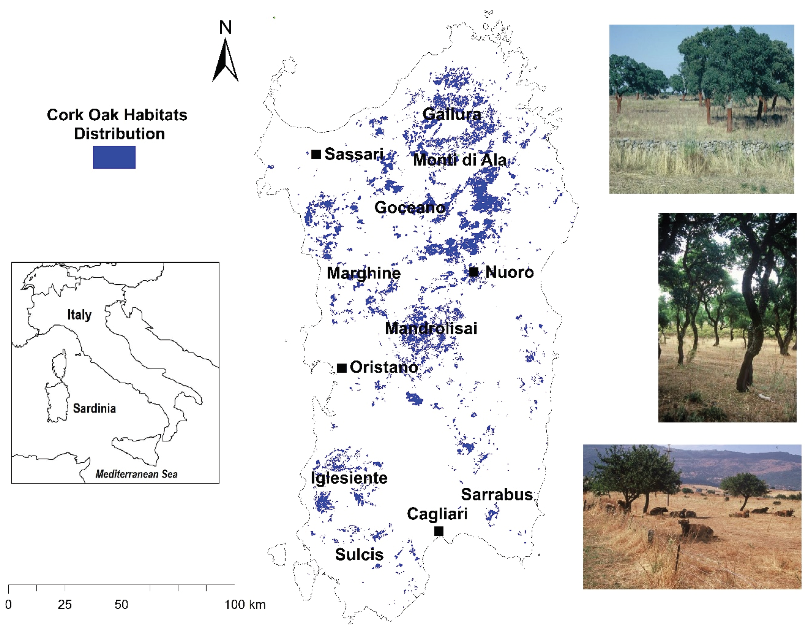
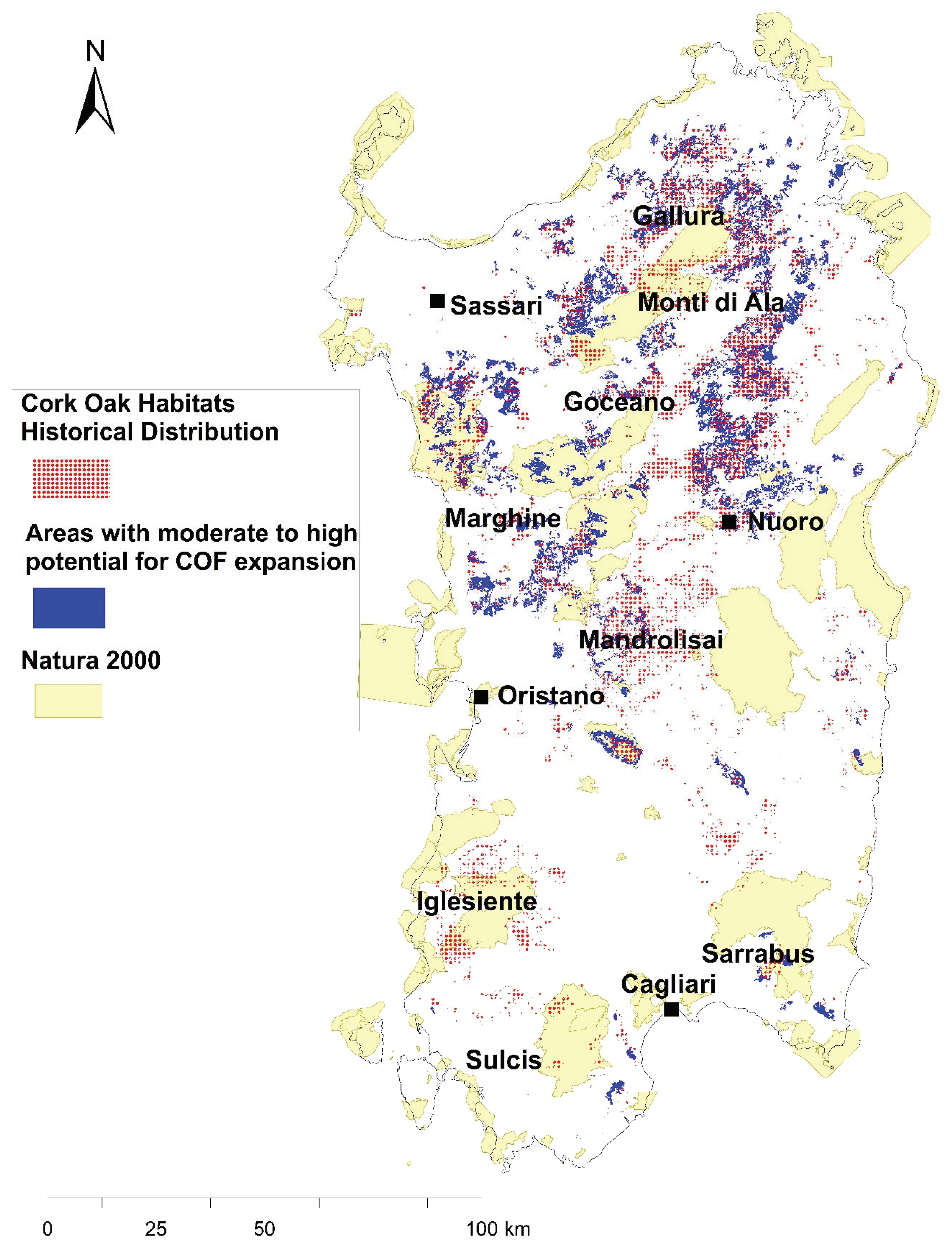
2.1. The Study Area
2.2. Spatial Model
2.3. Model Validation and Evaluation
3. Results
4. Discussion
4.1. Spatial Targeting and Model Functions
4.2. Validation
4.3. Management and Policy Implications
5. Conclusions
Author Contributions
Funding
Acknowledgments
Conflicts of Interest
References
- Nikolakaki, P.A. GIS site-selection process for habitat creation: Estimating connectivity of habitat patches. Landsc. Urban Plan. 2004, 68, 77–94. [Google Scholar] [CrossRef]
- Lee, J.T.; Bailey, N.; Thompson, S. Using Geographic Information Systems to identify and target sites for creation and restoration of native woodlands: A case study of the Chiltern Hills, UK. J. Environ. Manage. 2002, 64, 25–34. [Google Scholar] [CrossRef] [PubMed] [Green Version]
- Turner, M. Landscape Ecology: What is the state of the Science? Annu. Rev. Ecol. Evol. S 2005, 36, 319–344. [Google Scholar] [CrossRef]
- Dennis, P.; Hobbs, R.; Nassauer, J. Issues and Perspectives in Landscape Ecology; Wiens, J., Moss, M.R., Eds.; Cambridge University Press: Cambridge, UK, 2005; p. 412. [Google Scholar]
- Warnock, S.; Griffiths, G. Landscape characterisation: The living landscapes approach in the UK. Landsc. Res. 2015, 40, 261–278. [Google Scholar] [CrossRef]
- Neumann, J.L.; Griffiths, G.H.; Hoodless, A.; Holloway, G.J. The compositional and configurational heterogeneity of matrix habitats shape woodland carabid communities in wooded-agricultural landscapes. Landsc. Ecol. 2016, 31, 301–315. [Google Scholar] [CrossRef]
- Grove, A.T.; Rackham, O. The Nature of Mediterranean Europe. An Ecological History; Yale University Press: New Haven, CT, USA, 2001; p. 384. [Google Scholar]
- Leal, A.I.; Correia, R.A.; Granadeiro, J.P.; Palmeirim, J.M. Impact of cork extraction on birds: Relevance for conservation of Mediterranean biodiversity. Biol. Conserv. 2011, 144, 1655–1662. [Google Scholar] [CrossRef]
- Ojeda, F.; Arroyo, J.; Maranon, T. Biodiversity components and conservation of Mediterranean heathlands in southern Spain. Biol. Conserv. 2000, 72, 61–72. [Google Scholar] [CrossRef]
- Correia, E.; Freitas, H. Drosophyllum lusitanicum, an endangered West Mediterranean endemic carnivorous plant: Threats and its ability to control available resources. Bot. J. Linn. Soc. 2002, 140, 383–390. [Google Scholar] [CrossRef] [Green Version]
- Suarez, S.; Balbontin, J.; Ferrer, M. Nesting habitat selection for booted eagles (Hieraaetus pennatus) and implications for management. J. Appl. Ecol. 2000, 37, 215–223. [Google Scholar] [CrossRef] [Green Version]
- Commission of the European Communities. Rural Developments. CAP 2000 Working Document; European Commission DG VI: Brussels, Belgium, 1997; p. 74. [Google Scholar]
- Aronson, J.; Pereira, J.S.; Pausas, J.G. (Eds.) Cork Oak Woodlands on the Edge: Conservation, Adaptive Management, and restoration; Island Press: Washington, DC, USA, 2009; p. 315. [Google Scholar]
- Pe’er, G.; Dicks, L.V.; Visconti, P.; Arlettaz, R.; Báldi, A.; Benton, T.G.; Collins, S.; Dieterich, M.; Gregory, R.D.; Hartig, F.; et al. EU agricultural reform fails on biodiversity. Science 2014, 344, 1090–1092. [Google Scholar]
- Pinto-Correia, T. Future development in Portuguese rural areas: How to manage agricultural support for landscape conservation? Landsc. Urban Plan. 2000, 50, 95–106. [Google Scholar] [CrossRef]
- Pausas, J.G.; Bladé, C.; Valdecantos, A.; Seva, J.P.; Fuentes, D.; Alloza, J.A.; Vilagrosa, A.; Bautista, S.; Cortina, J.; Vallejo, R. Pines and oaks in the restoration of Mediterranean landscapes in Spain: New perspectives for an old practice-a review. Plant Ecol. 2004, 171, 209–220. [Google Scholar] [CrossRef]
- Costa, A.; Madeira, M.; Plieninger, T. Cork oak woodlands patchiness: A signature of imminent deforestation? Appl. Geogr. 2014, 54, 18–26. [Google Scholar] [CrossRef]
- Bugalho, M.N.; Caldeira, M.C.; Pereira, J.S.; Aronson, J.; Pausas, J.G. Mediterranean cork oak savannas require human use to sustain biodiversity and ecosystem services. Front. Ecol. Environ. 2011, 9, 278–286. [Google Scholar] [CrossRef] [Green Version]
- D’Angelo, M.; Enne, G.; Madraau, S.; Zucca, C. Land cover changes at landscape scale in Sardinia (Italy): The role of agricultural policies on land degradation. In Land Degradation; Conacher, A., Ed.; Springer: Dordrecht, The Netherlands, 2001; pp. 127–140. [Google Scholar]
- Vacca, A. Effect of land use on forest floor and soil of a Quercus suber L. forest in Gallura (Sardinia, Italy). Land Degrad. Dev. 2000, 11, 167–180. [Google Scholar] [CrossRef]
- Vogiatzakis, I.N.; Griffiths, G.H.; Bacchetta, G. Human impacts on Quercus suber woodland habitats in Sardinia: Past and present. Botanika Chronika 2005, 18, 277–284. [Google Scholar]
- European Commission European Red List of Habitats: Part 2; Terrestrial and Freshwater Habitats Publications Office of the European Union: Luxembourg, 2016; p. 44.
- Griffiths, G.H.; Vogiatzakis, I.N. Chapter 20: Habitat Approaches to Nature Conservation. In Handbook of Biogeography; Blumler, M., MacDonald, G., Millington, A., Schickhoff, U., Eds.; Sage Publications: New York, NY, USA, 2011; p. 624. [Google Scholar]
- Thomson, J.R.; Moilanen, A.J.; Vesk, P.A.; Bennett, A.F.; Nally, R.M. Where and when to revegetate: A quantitative method for scheduling landscape reconstruction. Ecol. Appl. 2009, 19, 817–828. [Google Scholar] [CrossRef] [Green Version]
- Vizzarri, M.; Sallustio, L.; Travaglini, D.; Bottalico, F.; Chirici, G.; Garfì, V.; Lafortezza, R.; La Mela Veca, D.S.; Lombardi, F.; Maetzke, F.; et al. The MIMOSE Approach to Support Sustainable Forest Management Planning at Regional Scale in Mediterranean Contexts. Sustainability 2017, 9, 316. [Google Scholar] [CrossRef] [Green Version]
- Margules, C.; Sankar, S. (Eds.) Systematic Conservation Planning; Cambridge University Press: Cambridge, UK, 2007; p. 278. [Google Scholar]
- Moilanen, A. Landscape zonation, benefit functions and target-based planning: Unifying reserve selection strategies. Biol. Conserv. 2007, 134, 571–579. [Google Scholar] [CrossRef]
- Knight, A.T.; Cowling, R.M.; Rouget, M.; Balmford, A.; Lombard, A.T.; Campbell, B.M. Knowing but not doing: Selecting priority conservation areas and the research–implementation gap. Conserv. Biol. 2008, 22, 610–617. [Google Scholar] [CrossRef]
- Villero, D.; Pla, M.; Camps, D.; Ruiz-Olmo, J.; Brotons, L. Integrating species distribution modelling into decision-making to inform conservation actions. Biodivers. Conserv. 2017, 26, 251–271. [Google Scholar] [CrossRef]
- Margules, C.R.; Pressey, R.L. Restoration ecology: A Synthetic Approach to Ecological Research; Jordan, W.R., Gilpin, M.E., Aber, J.D., Eds.; Cambridge University Press: Cambridge, UK, 1990; p. 352. [Google Scholar]
- Glenk, K.; Schaafsma, M.; Moxey, A.; Martin-Ortega, J.; Hanley, N. A framework for valuing spatially targeted peatland restoration. Ecosyst. Serv. 2014, 9, 20–33. [Google Scholar] [CrossRef]
- Balaguer, L.; Escudero, A.; Martin-Duque, J.F.; Mola, I.; Aronson, J. The historical reference in restoration ecology: Re-defining a cornerstone concept. Biol. Conserv. 2014, 176, 12–20. [Google Scholar] [CrossRef]
- Holl, K.D.; Crone, E.E.; Schultz, C.B. Landscape Restoration: Moving from generalities to methodologies. BioScience 2003, 53, 491–502. [Google Scholar] [CrossRef] [Green Version]
- George, T.L.; Zack, S. Spatial and temporal considerations in restoring habitat for wildlife. Restor. Ecol. 2001, 9, 272–279. [Google Scholar] [CrossRef]
- Hidalgo, P.J.; Marín, J.M.; Quijada, J.; Moreira, J.M. A spatial distribution model of cork oak (Quercus suber) in southwestern Spain: A suitable tool for reforestation. For. Ecol. Manag. 2008, 255, 25–34. [Google Scholar] [CrossRef]
- Vessella, F.; Schirone, B. Predicting potential distribution of Quercus suber in Italy based on ecological niche models: Conservation insights and reforestation involvement. For. Ecol. Manag. 2013, 304, 150–161. [Google Scholar] [CrossRef]
- Paulo, J.A.; Pereira, H.; Tomé, M. Analysis of variables influencing tree cork caliper in two consecutive cork extractions using cork growth index modelling. Agroforest Syst. 2017, 91, 221–237. [Google Scholar] [CrossRef]
- Arrigoni, P.V. Fitoclimatologia della Sardegna. Webbia 1968, 23, 1–100. [Google Scholar] [CrossRef]
- RAS (Regione Autonoma della Sardegna). Carta Dell’ Uso Del Suolo Scala 1:25 000. Note Illustrative; RAS: Assesorato degli Enti Locali, Finanze ed Urbanistica: Cagliari, Italy, 2003. [Google Scholar]
- Barneschi, L. Carta Forestale della Sardegna. Stazione Sperimentale del Sughero; Settore Forestale: Tempio Pausania, Italia, 1988. [Google Scholar]
- Commission of the European Communities. CORINE Biotopes: The Design, Compilation and Use of an Inventory of Sites of Major Importance for Nature Conservation in the European Community; Commission of the European Communities: Luxembourg, 1991. [Google Scholar]
- ESRI. ArcMap, Version 10.1; Environmental Systems Research Institute: Redlands, CA, USA, 2012. [Google Scholar]
- Griffiths, G.H.; Vogiatzakis, I.N.; Porter, J.; Burrows, C. A landscape scale spatial model for semi-natural broadleaf woodland expansion in Wales, UK. J. Nat. Conserv. 2011, 19, 43–53. [Google Scholar] [CrossRef]
- Ciancio, O.; Corona, P.; Marchetti, M.; Chirici, G.; Barbati, A.; Travaglini, D. Carta Degli Aspetti Paesistici d’Italia. Relazione Tecnica Finale; Università degli Studi di Firenze: Firenze, Italia, 2004. [Google Scholar]
- Cohen, J. Weighted kappa: Nominal scale agreement provision for scaled disagreement or partial credit. Psychol. Bull. 1968, 70, 54. [Google Scholar] [CrossRef] [PubMed]
- Store, R.; Kangas, J. Integrating spatial multi-criteria evaluation and expert knowledge for GIS-based habitat suitability modeling. Landsc. Urban Plan. 2001, 55, 79–93. [Google Scholar] [CrossRef]
- Pons, J.; Pausas, J.G. Oak regeneration in heterogeneous landscapes: The case of fragmented Quercus suber forests in the eastern Iberian Peninsula. For. Ecol. Manag. 2006, 231, 196–204. [Google Scholar] [CrossRef]
- Wilson, K.A.; Lulow, M.; Burger, J.; Fang, Y.C.; Andersen, C.; Olson, D.; O’Connell, M.; McBride, M.F. Optimal restoration: Accounting for space, time and uncertainty. J. Appl. Ecol. 2011, 48, 715–725. [Google Scholar] [CrossRef]
- Tambosi, L.R.; Martensen, A.C.; Ribeiro, M.C.; Metzger, J.P. A framework to optimize biodiversity restoration efforts based on habitat amount and landscape connectivity. Restor. Ecol. 2014, 22, 169–177. [Google Scholar] [CrossRef]
- Vogiatzakis, I.N.; Stirpe, M.T.; Rickebusch, S.; Metzger, M.; Xu, G.; Rounsevell, M.; Bommarco, R.; Potts, S.G. Rapid assessment of historic, future and current habitat quality for biodiversity around UK Natura 2000 sites. Environ. Conserv. 2015, 42, 31–40. [Google Scholar] [CrossRef]
- Riedler, B.; Lang, S. A spatially explicit patch model of habitat quality, integrating spatio-structural indicators. Ecol. Indic. 2018, 94, 128–141. [Google Scholar] [CrossRef]
- Dettori, S.; Filigheddu, M.R.; Deplano, G.; Molgora, J.E.; Ruiu, M.; Sedda, L. Employing a spatio-temporal contingency table for the analysis of cork oak cover change in the Sa Serra region of Sardinia. Sci. Rep. 2018, 8, 1–4. [Google Scholar] [CrossRef] [Green Version]
- Altamirano, A.; Miranda, A.; Meli, P.; Dehennin, J.; Muys, B.; Prado, M.; Catalán, G.; Smith-Ramírez, C.; Bustamante-Sánchez, M.; Lisón, F.; et al. Spatial congruence among indicators of recovery completeness in a Mediterranean forest landscape: Implications for planning large-scale restoration. Ecol. Indic. 2019, 102, 752–759. [Google Scholar] [CrossRef]
- Malczewski, J. On the use of weighted linear combination method in GIS: Common and best practice approaches. Trans. GIS 2000, 4, 5–22. [Google Scholar] [CrossRef]
- Lengyel, S.; Kobler, A.; Kutnar, L.; Framstad, E.; Henry, P.Y.; Babij, V.; Gruber, B.; Schmeller, D.; Henle, K. A review and a framework for the integration of biodiversity monitoring at the habitat level. Biodivers Conserv. 2008, 17, 3341–3356. [Google Scholar] [CrossRef]
- Tomaselli, V.; Dimopoulos, P.; Marangi, C.; Kallimanis, A.S.; Adamo, M.; Tarantino, C.; Panitsa, M.; Terzi, M.; Veronico, G.; Lovergine, F.; et al. Translating land cover/land use classifications to habitat taxonomies for landscape monitoring: A Mediterranean assessment. Landsc. Ecol. 2013, 28, 905–930. [Google Scholar] [CrossRef] [Green Version]
- McDonald, T.; Jonson, J.; Dixon, K.W. National standards for the practice of ecological restoration in Australia. Restor. Ecol. 2016, 24, S4–S32. [Google Scholar] [CrossRef] [Green Version]
- Millar, C.I.; Stephenson, N.L.; Stephens, S.L. Climate change and forests of the future: Managing in the face of uncertainty. Ecol. Appl. 2007, 17, 2145–2151. [Google Scholar] [CrossRef] [PubMed]
- Plieninger, T.; Pulido, F.J.; Konold, W. Effects of land-use history on size structure of holm oak stands in Spanish dehesas: Implications for conservation and Restoration. Environ. Conserv. 2003, 30, 61–70. [Google Scholar] [CrossRef]
- Picuno, P.; Cillis, G.; Statuto, D. Investigating the time evolution of a rural landscape: How historical maps may provide environmental information when processed using a GIS. Ecol. Eng. 2019, 139, 105580. [Google Scholar] [CrossRef]
- Vogiatzakis, I.N. Mediterranean experience and practice in Landscape Character Assessment. Ecol. Mediterr. 2011, 37, 17–31. [Google Scholar] [CrossRef]
- Genovesi, P.; Angelini, P.; Bianchi, E.; Dupré, E.; Ercole, S.; Giacanelli, V.; Ronchi, F.; Stoch, F. Specie e Habitat di Interesse Comunitario in Italia: Distribuzione, Stato di Conservazione e Trend; ISPRA, Serie Rapporti, 194/2014; ISPRA: Roma, Italy, 2014. [Google Scholar]
- Rounsewell, M.D.A.; Reginster, I.; Araújo, M.B.; Carter, T.R.; Dendoncker, N.; Ewert, F.; House, J.I.; Kankaanpa, S.; Leemans, R.; Metzger, M.J.; et al. A coherent set of future land use change scenarios for Europe. Agric. Ecosyst. Environ. 2006, 114, 57–68. [Google Scholar] [CrossRef]
- Bryan, B.A.; King, D.; Ward, J.R. Modelling and mapping agricultural opportunity costs to guide landscape planning for natural resource management. Ecol. Indic. 2011, 11, 199–208. [Google Scholar] [CrossRef]
- Guisan, A.; Tingley, R.; Baumgartner, J.B.; Naujokaitis-Lewis, I.; Sutcliffe, P.R.; Tulloch, A.I.; Regan, T.J.; Brotons, L.; McDonald-Madden, E.; Mantyka-Pringle, C.; et al. Predicting species distributions for conservation decisions. Ecol. Lett. 2013, 16, 1424–1435. [Google Scholar] [CrossRef]
- Vogiatzakis, I.N.; Manolaki, P. Investigating the diversity and variability of Eastern Mediterranean Landscapes. Land 2017, 6, 71. [Google Scholar] [CrossRef] [Green Version]
- Vogiatzakis, I.N.; Zomeni, M.; Mannion, A.M. Characterizing islandscapes: Conceptual and methodological challenges exemplified in the Mediterranean. Land 2017, 6, 14. [Google Scholar] [CrossRef] [Green Version]
- Manolaki, P.; Zotos, S.; Vogiatzakis, I.N. An integrated ecological and cultural framework for landscape sensitivity assessment in Cyprus. Land Use Policy 2020, 1, 104336. [Google Scholar] [CrossRef]
- Harrison, P.A.; Berry, P.M.; Butt, N.; New, M. Modelling climate change impacts on species’ distributions at the European scale: Implications for conservation policy. Environ. Sci. Policy 2006, 9, 116–128. [Google Scholar] [CrossRef]
- Hodgson, J.A.; Thomas, C.D.; Cinderby, S.; Cambridge, H.; Evans, P.; Hill, J.K. Habitat re-creation strategies for promoting adaptation of species to climate change. Conserv. Lett. 2011, 4, 289–297. [Google Scholar] [CrossRef]
- Vos, C.C.; Berry, P.; Opdam, P.; Baveco, H.; Nijhof, B.; O’Hanley, J.; Bell, C.; Kuipers, H. Adapting landscapes to climate change: Examples of climate-proof ecosystem networks and priority adaptation zones. J. Appl. Ecol. 2008, 45, 1722–1731. [Google Scholar] [CrossRef]
- Cook, C.N.; Mascia, M.B.; Schwartz, M.W.; Possingham, H.P.; Fuller, R.A. Achieving conservation science that bridges the knowledge–action boundary. Conserv. Biol. 2013, 274, 669–678. [Google Scholar] [CrossRef] [Green Version]


| Function | Description | Mapped Result |
|---|---|---|
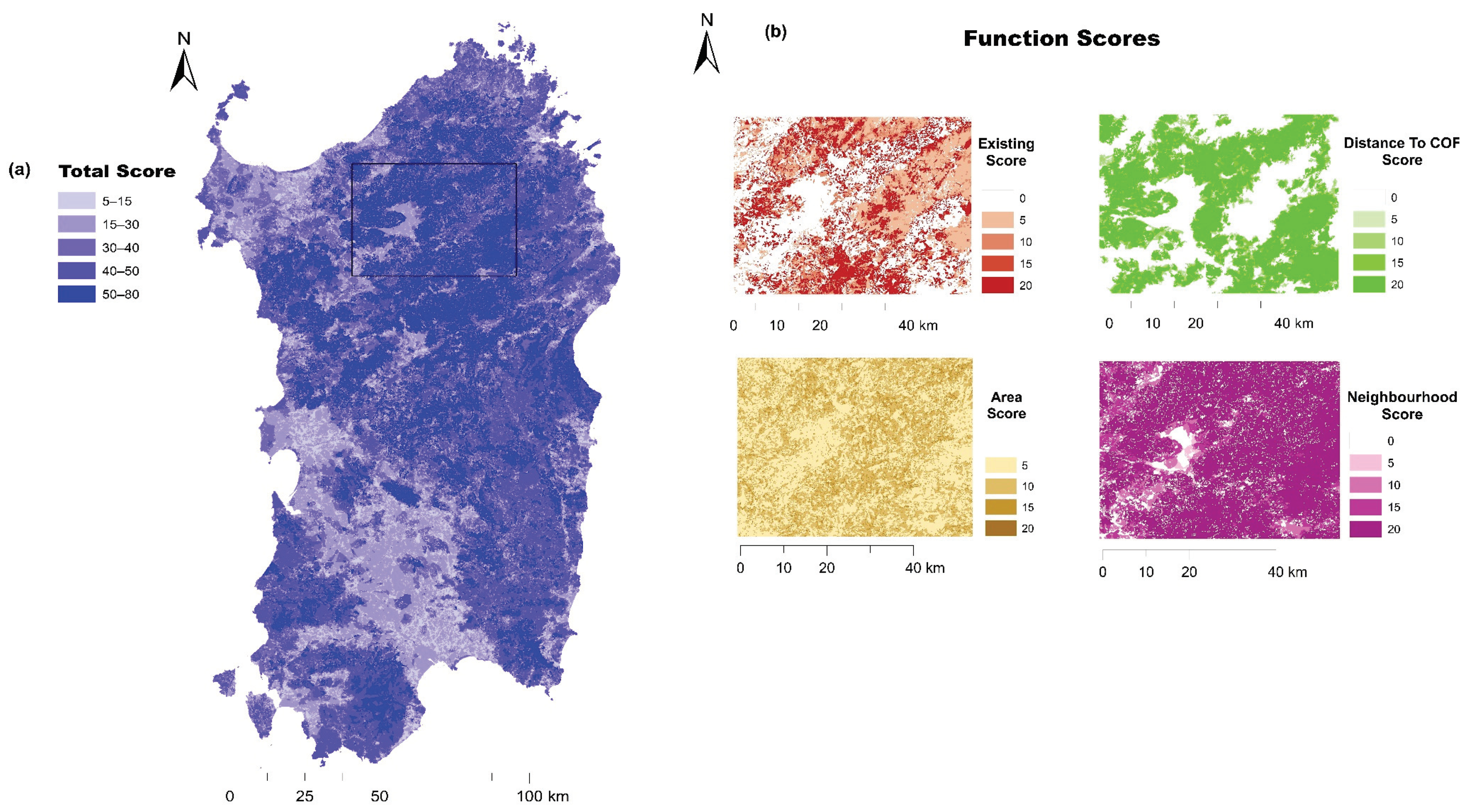
| Existing | Returns a suitability score for the Active Land Parcel, based upon the existing land cover of that parcel. This tests whether the existing land cover type is appropriate for conversion into the Target Habitat. A score of zero indicates that the exiting land cover type is inappropriate for the creation of the Target Habitat. It may also be valid to convert one seminatural land cover type to another. | The mapped results for this spatial function demonstrate that the areas containing the most appropriate land cover types for conversion into the target habitat type are found east of Nuoro, east and west of Cagliari, in the area of Inglesiente and in the north around Goceano and Mandrolisai. |
| Area | Returns a suitability score for the Active Land Parcel, based upon the area of the parcel. This function allows targets to be set that will favor the creation of land cover type patches of a specific area (ha); for example, the creation of relatively larger land cover type patches with the potential for an increased complement of species. | Highly suitable areas, i.e., > 25 ha, seem to be widely distributed on the island with no specific pattern/concentration, i.e., areas which merit particular mention. |
| Distance To | Assigns a suitability code to the Active Land Parcel based upon the distance from the boundary of the parcel to a patch of land cover type of the target land cover type. Land Parcels that are close to seminatural land cover type of the same target land cover type will score higher, thus favoring the spatial concentration of land cover types of the same type. | The mapped results for this spatial function demonstrate that predictably highly suitable areas, i.e., < 20 m are located in the northern part of the island. |
| Neighborhood | Defines a fixed width buffer adjacent to the outside edge of the Active Land Parcel and measures the proportion of seminatural land cover within the buffer zone. This permits targets to be set that favor the creation of new land cover types in parcels that are surrounded by a high proportion of seminatural land cover types. | According to the mapped results for this rule, there are many areas with high suitability, i.e., > 50% cover of seminatural habitats within a 100 m buffer. Large parts of the island are still covered by seminatural habitats in the north east and south east, but also in the south west. |
| Calculate Scores | Calculates Suitability Scores for land cover type creation for each Active Land Parcel, based upon the Suitability Codes assigned by the individual functions and their numeric equivalents as shown in Table 2. This function then calculates a total score which is a simple sum of the results of the individual model functions. | Figure 2 shows the total suitability scores for conversion to cork oak forest for the study area. It is the sum of all model components according to Equation (1) (See text). |
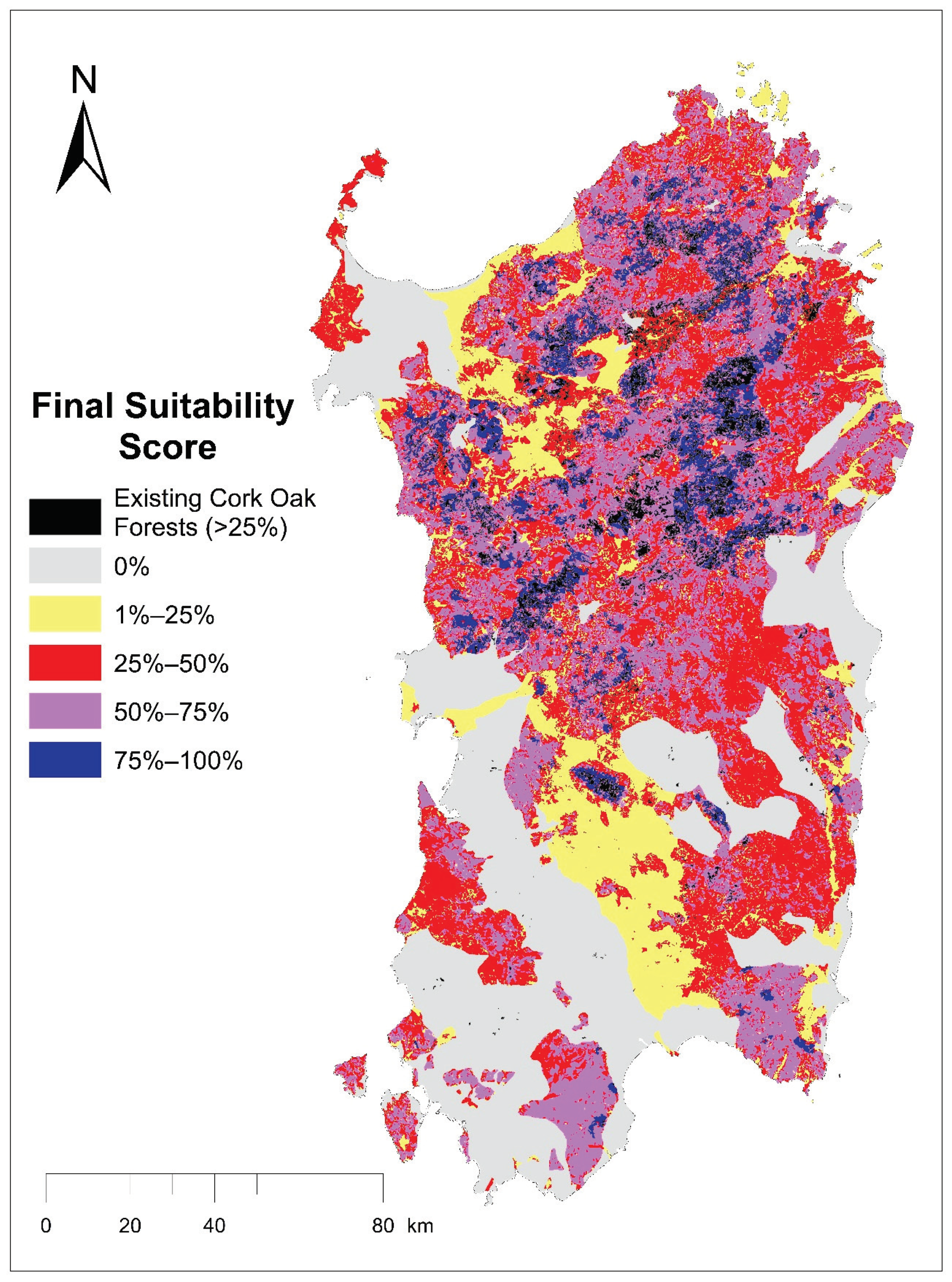
| Intersect | Assigns a suitability code to the Active Land Parcel according to the landscape type that the parcel intersects with. This function permits the targeting of a land cover type to landscape types that are particularly suited to the creation of that land cover type. | The decision rules applied in the model so far assume an isotropic landscape, in which differences in physical and cultural patterns are unaccounted for. Therefore, we incorporated landscape character as an influence on the suitability of a land parcel to conversion to cork oak forest. The final result according to Equation (2) (See text) is given in Figure 3. |
| Functions | Parameter | Suitability Code * | Score |
|---|---|---|---|
| Existing Land cover type | Agriculture associated with cork oak | A | 20 |
| Agroforestry areas, Deciduous forests, Maquis, Garigue, Transitional woodland/shrub | B | 15 | |
| Natural grassland, Plantations | C | 10 | |
| Vineyards, Olives, Complex cultivation systems, Land principally occupied by agriculture with significant areas of natural vegetation, Nonirrigated arable land, Permanently irrigated land, Coniferous forests, Riparian shrubs | D | 5 | |
| Construction sites, Bare rock, Sparsely vegetated areas, Urban, Industrial, Infrastructure, Sports parks, Beaches, Rivers, Water bodies | E | 0 | |
| Area of Active Land Parcel | ≥25 hectares | A | 20 |
| 5–25 hectares | B | 15 | |
| 2–5 hectares | C | 10 | |
| <2 hectares | D | 5 | |
| Distance to COF | ≤20 m | A | 20 |
| ≤100 m | B | 15 | |
| ≤250 m | C | 10 | |
| >250 m | E | 0 | |
| Neighborhood (Percentage of Seminatural land cover type in 100 m Buffer) | |||
| >50% | A | 20 | |
| 20%–50% | B | 15 | |
| 5%–20% | C | 10 | |
| 1%–5% | D | 5 | |
| ≤1% | E | 0 | |
| Landscape Type ** | Granite Mountains | A | 20 |
| Granite Hills | A | 20 | |
| Sedimentary Hills | B | 15 | |
| Volcanic Plateau and Hills | B | 15 | |
| Metamorphic Hills | C | 10 | |
| Alluvial Plains | C | 10 | |
| Agreement Classes | Pixels | %Total |
|---|---|---|
| 1. Included in both maps | 520 | 52 |
| 2. Excluded in both maps | 295 | 29.5 |
| 3. Included only in the suitability map. | 90 | 9 |
| 4. Included only in the historical map | 95 | 9.5 |
| Overall Agreement = 81.5% | Cohen’s Kappa = 0.61 |
© 2020 by the authors. Licensee MDPI, Basel, Switzerland. This article is an open access article distributed under the terms and conditions of the Creative Commons Attribution (CC BY) license (http://creativecommons.org/licenses/by/4.0/).
Share and Cite
Vogiatzakis, I.N.; Griffiths, G.H.; Zomeni, M. Incorporating Landscape Character in Cork Oak Forest Expansion in Sardinia: Constraint or Opportunity? Forests 2020, 11, 593. https://doi.org/10.3390/f11050593
Vogiatzakis IN, Griffiths GH, Zomeni M. Incorporating Landscape Character in Cork Oak Forest Expansion in Sardinia: Constraint or Opportunity? Forests. 2020; 11(5):593. https://doi.org/10.3390/f11050593
Chicago/Turabian StyleVogiatzakis, Ioannis N., Geoffrey H. Griffiths, and Maria Zomeni. 2020. "Incorporating Landscape Character in Cork Oak Forest Expansion in Sardinia: Constraint or Opportunity?" Forests 11, no. 5: 593. https://doi.org/10.3390/f11050593