Article

A Geospatial Decision Support System Tool for Supporting Integrated Forest Knowledge at the Landscape Scale

1
Department of Agriculture, University of Napoli Federico II, Via Università 100, 80055 Portici (Naples), Italy
2
CRISP Research Center, Department of Agriculture, University of Napoli Federico II, Via Università 100, 80055 Portici (Naples), Italy
3
Institute for Mediterranean Agricultural and Forest Systems, National Research Council, Via Patacca 85, 80056 Ercolano, Italy
4
Ariespace Srl, Centro Direzionale, Isola A3, 80143 Naples, Italy
*
Author to whom correspondence should be addressed.
Forests 2019, 10(8), 690; https://doi.org/10.3390/f10080690
Submission received: 23 May 2019 / Revised: 7 August 2019 / Accepted: 12 August 2019 / Published: 14 August 2019
(This article belongs to the Section Forest Economics, Policy, and Social Science)

Abstract

:
Forests are part of a complex landscape mosaic and play a crucial role for people living both in rural and urbanized spaces. Recent progresses in modelling and Decision Support System (DSS) applied to the forestry sector promise to improve public participative forest management and decision-making in planning and conservation issues. However, most DSS are not open-source systems, being in many cases software designed for site-specific applications in forest ecosystems. Furthermore, some of these systems often miss challenging the integration of other land uses within the landscape matrix, which is a key issue in modern forestry planning aiming at linking recent developments in open-source Spatial-DSS systems to sectorial forest knowledge. This paper aims at demonstrating that a new type of S-DSS, developed within the Life+ project SOILCONSWEB over an open-source Geospatial Cyber-Infrastructure (GCI) platform, can provide a strategic web-based operational tool for forest resources management and multi-purpose planning. In order to perform simulation modelling, all accessible via the Web, the GCI platform supports acquisition and processing of both static and dynamic data (e.g., spatial distribution of soil and forest types, growing stock and yield), data visualization and computer on-the-fly applications. The DSS forestry tool has been applied to a forest area of 5,574 ha in the southern Apennines of Peninsular Italy, and it has been designed to address forest knowledge and management providing operational support to private forest owners and decision-makers involved in management of forest landscape at different levels. Such a geospatial S-DSS tool for supporting integrated forest knowledge at landscape represents a promising tool to implement sustainable forest management and planning. Results and output of the platform will be shown through a short selection of practical case studies.

Graphical Abstract

1. Introduction

1.1. Forest DSS Systems

Forest planning processes and management options are complex interconnected tasks, since nowadays they must cope with the multifunctional roles of forest ecosystems with the different spatial and temporal scales of decision-making and finally the changing economic, administrative, legal, and social scenarios [1]. Since the establishment of the new paradigm of Sustainable Forest Management (named as SFM) by the Helsinki resolution [2,3], policymakers are more than ever advocating for advanced and integrated forest knowledge at landscape scale. Definitely, the forestry sector is evolving into a multi-purpose role which concerns over the environment, biodiversity, protection, provision of amenity and recreational facilities that are merging together with the more traditional requirements of timber production [4]. In forest science, several models have been developed in the last decade to provide basic operational tools to be applied within various forest management contexts [5]. For instance, yield and growth models have classically been used to assess profits, to plan harvesting schedules and silvicultural treatment of even aged forest stands and have been further implemented in more sophisticated prediction models and research tools [6]. The large number of issues relating to forest management make the development of forest plans a complex process [1]. As a consequence, objectives and approaches have been changing over time and accordingly the demand for tools to support planning and decision-making has evolved [7] and will probably keep on evolving. Indeed, forest research community realized—much earlier than many other scientific domains—that it was essential to implement such models into operational Decision Support System (DSS), in order to assist operational forest planning and management at several scales. Since the 1980s, Decision Support Systems (DSSs) have become popular platforms for transferring knowledge from science into practical forest management [8], henceforth several DSSs have been specifically designed and developed within forest communities [9] aiming at modelling and then managing forest ecosystems for several purposes such as production, protection and recreational functions. DSSs applied to forestry and integrated with GIS tools include also spatial components, therefore aiming at tackling territorial problems and involving stakeholders in participatory processes [1]. The GIS tool integration within DSS has led to the steady development of spatial DSSs (S-DSSs) that represent. valuable tools for helping decision-makers analyzing complex spatial problems into their components for supporting more efficiently multiple purpose forest resource planning [10,11,12,13,14]. Since ecological and environmental considerations are important for individual forest-owners/decision-makers as well for society in its whole, there is an increasing need to get higher quality information on the spatial structure of forests and to develop means by which spatial objectives can be explicitly included in forest planning [11]. New technologies such as UAVs (Unmanned Aerial Vehicle such as drones) and LiDAR (Light Detection And Ranging) represent new forest stand parameters acquisition tools making it possible to obtain accurate data over large areas [15]. LiDAR systems, commonly mounted on satellite, airplanes or helicopters, represent a solid innovation for mapping forest attributes on spatially extensive areas and their use finds several applications in forest inventory as well as to support decision-making sustainable forest management processes [16]. For example, some S-DSS have proven a novel application of LiDAR data to assess wood production under various harvesting options or the integration of a visualization system with modelling as a new approach to forest management planning and decision-making [17,18,19]. The application of decision support tools can help to improve the effectiveness of the decisional process, thus using resources and manage forests efficiently [20] especially when spatial information is integrated within the system. Some examples of S-DSS include AFFOREST [21], Wildalpen [22], FOpP [23], Biomasfor [24], and TooFE [25]. As common ground, the majority of these S-DSS has been developed to tackle site-specific forest management issues such as the need of combining silvicultural and harvesting operations or carry out regeneration planning in protection forests [26]. However, it should be noted that these systems are mostly conceived in the shape of software developed for professional use to be applied to a specific geographic area for which they have been specifically designed, in addition, few online tools are designed for private and non-professional forest owners in a user-friendly environment [27]. Web technologies can help building platform-independent distributed computation facilitating the exchange of complex information [28]. Recent applications of web-GIS services allow us to overcome limitations in public participation processes enabling public participation in decisions designing tools that support understanding of environmental issues, develop and evaluate alternatives projecting the consequences of different courses of action [7]. The need of spatial analysis, open-source platform and easy to use web capabilities is growing day by day as such systems are capable of offering—through a smart Web-based system—a truly integrated geospatial knowledge archive which can be used directly and freely by any end user [29]. In order to get some understanding about whether and how open source and web capabilities have been implemented into S-DSS applied to forestry, in particular for supporting forest management planning [30], we have reviewed current DSS literature, primarily the works carried out by Packalen [9] and Borges [31]. We found out that among the 62 DSS-like software systems dealing with forest management (from 23 countries) and reported within FORSYS Wiki, none of them had all of the following attributes: (i) open-source codes, (ii) web-based systems, and (iii) geospatial analysis [9]. A detailed metanalysis overview about the 62 Forest DSS systems is provided in the Supplementary Materials Table S1. Some of the most promising lines of future DSS developments include the use of the web to enable easy access to public data and enhance the capability of participatory decision-making processes [8]. Recent developments in S-DSSs occurring in other domains [32,33,34] are delivering interesting opportunities in land management and planning by combining open-access WEB-GIS systems and open-source codes. In fact, this combination provides -through the web- freely access of critical geospatial data to any end-user while the open-source approach creates strong synergies with new code development, especially those occurring in other domains. Both these features empower the so-called FAIR (Findable, Accessible, Interoperable and Reusable) criteria [35]—Guiding Principles for scientific data management and stewardship craved by the European Union—which in turn enable future reuse of data and models. A review conducted by McIntosh [36] investigated key success and weak points of several DSSs that have been developed in the past across several countries and with different focus. The main challenge highlighted regards the operational adoption of DSS by end-users. The study outlines how, despite the effort in involving public participation in shaping DSS, most DSS have either not adopted at all or, if used, only for a short time. In addition, considering the many DSS available for forest management and planning, we wonder whether the proliferation of many S-DSS systems each one of those adapted to a specific site is a good way to go. We shall seek for integration and adaptability taking also into account that the more general a system is intended to be, the more adaptable it must be on the programming side, because the developers will need to alter, add and remove many features as they encounter new users in new situations [7]. Thus, in forestry we must seek for S-DSS systems that include the following features: interoperability, replicability, modularity, web-based and open source.

1.2. Aims

Considering the above framework, the general aim of this paper is to demonstrate that a new type of DSSs developed over Geospatial Cyber-Infrastructure (GCI) platform can provide a strategic and flexible web-based operational tool to challenge multifunctional and sustainable forestry knowledge for planning and management purposes at the landscape level, with a demonstration of potential deliveries at high spatial detail (e.g., Cadastral ID) and for large spatial extent areas. The forestry tool reported here (named GIFT tool which stands for “Geospatial Integrated Forest knowledge Tool”) is a component of a more general multipurpose Geospatial Decision Support System (S-DSS) named SOILCONSWEB [29], currently in use (www.landconsultingweb.eu) and fully active within the limit of the administrative boundaries of Telesina Valley (South Italy, Benevento). This system is currently under further development under the H2020 LANDSUPPORT project (www.landsupport.eu). Here the Forestry management planning support tool will be described with its main functionalities and modelling engines. We chose to shape GIFT focusing on forest management planning in order to comply with the followings: (i) the necessity of safeguarding and maintaining the forest ecosystem and its functions in the area of study providing a tool that could improve the understanding of goods and services derived from forests; (ii) the forest owner’s needs of managing forest resources, providing support to the planning and an assessment of the activities necessary to meet the requested objectives [30].
Moreover, through a short selection of applicative case studies two main domains of applications will be demonstrated, namely: (i) the use of LiDAR data to be related to forest productivity (i.e., growing stock) as tool for forest management planning, (ii) landslide and soil erosion risk analysis conducted on the basis of geomorphology and soil data modelling to support forest road network concessions by the public authority within the Camposauro Regional Park’s protected area.

2. Materials and Methods
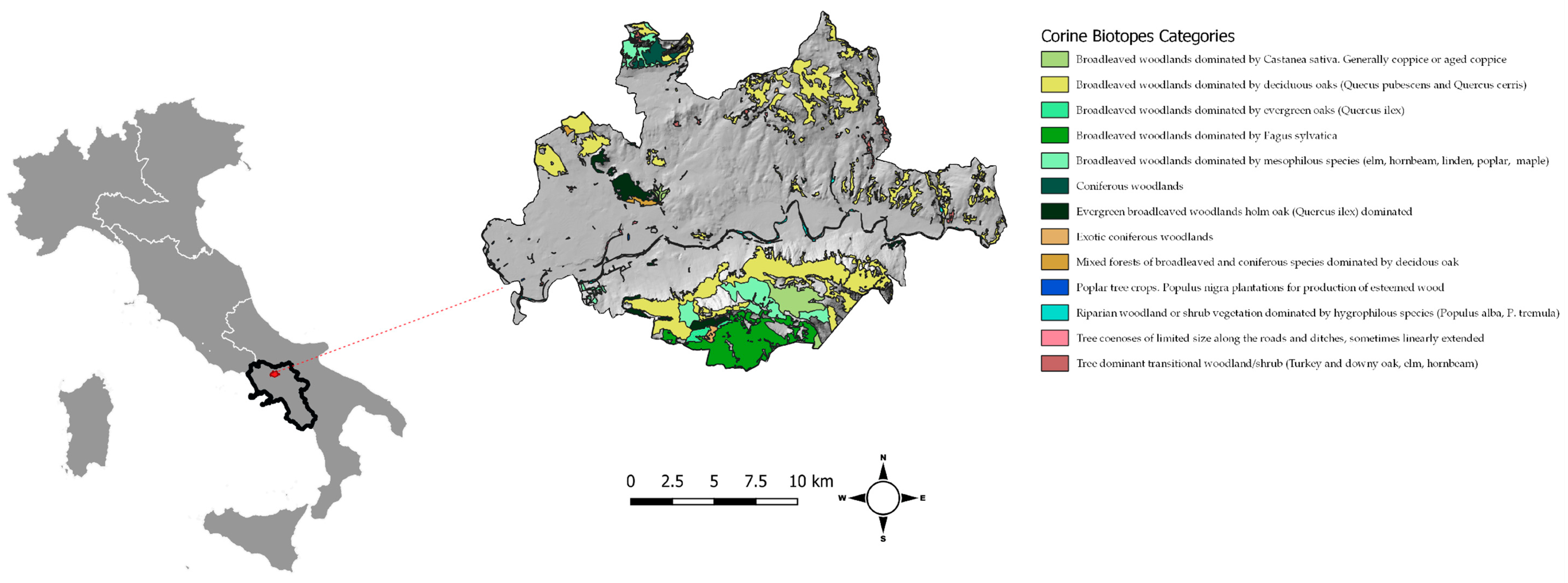
2.1. The Study Area

The GIFT forestry tool—applied to a forest area of 5.574 ha (South Italy)—has been designed to address sustainable forestry knowledge for integrated forest management planning in a complex landscape, providing operational support to foresters and decision-makers involved in forest planning at the landscape scale. The study area (Figure 1) is the Telesina Valley (~20,000 ha, 41°12′59.37″ N, 14°31′33.43″ E in southern Apennines, Italy), featuring a cultivated flat area, crossed by the Calore river and lying between the northern and southern slopes respectively by the Matese mountain chain and the isolated calcareous Taburno-Camposauro massif. The Telesina Valley represents a mosaic of different vegetation and land use types, including Mediterranean broadleaf—evergreen and deciduous—forests, conifer plantations, pasture grasslands, vineyards, olive groves and urban settlements [37]. The territory has a large forestry landscape (27.7% of the study area) and it is also known as suitable for the production of high-quality agriculture. The area includes 60 Soil Typological Units, the main soil types includes Silandic, Melanic, Mollic, Eutrosilic, Vitric Andosols, Haplic and Vertic Calcisols, Vertic Leptic Cambisol, Haplic Regosol, Vitric Phaeozem, Vitric Luvisol, Calcic Kastanozem, Vitric Kastanozem, Fluvic Cambisol (IUSS Working Group WRB. 2015). Soil types are spatially aggregated into 47 Soil Mapping Units. The importance of the study area is increased due to the fact that Telesina valley hosts three different Sites of Community Importance (SCIs) under the 92/43/EEC Habitat Directive namely: Camposauro (IT 8020007), Monte Mutria (IT 802009) and the Fiumi Volturno and Calore Beneventano (IT 8010027) and the Massiccio del Matese Special Protection Area (SPA) (IT 8010026) under the 2009/147/EC. Forests were classified according to European forest type classes [38], while the definition of main silvicultural system (e.g., high forests or coppices) derived from field surveys, expert judgement and the published forest management plans of several municipalities within the Telesina Valley. Eight forest types were selected and analyzed in the study area, corresponding to different silvicultural systems, including high forest (HF), coppices (C), and transitional stands produced by the conversion of coppice to high forest (C-HF). Overall, the thermophilous deciduous forest category covered 72.3% of the total forest land, followed by the Mountainous beech forest (13.6%) and Broadleaved evergreen forest (6.0%) categories. The plantations and self-sown exotic forest (5.0%), Floodplain forest (3.2%) categories are also recognized.

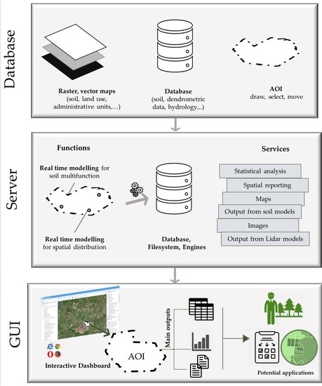
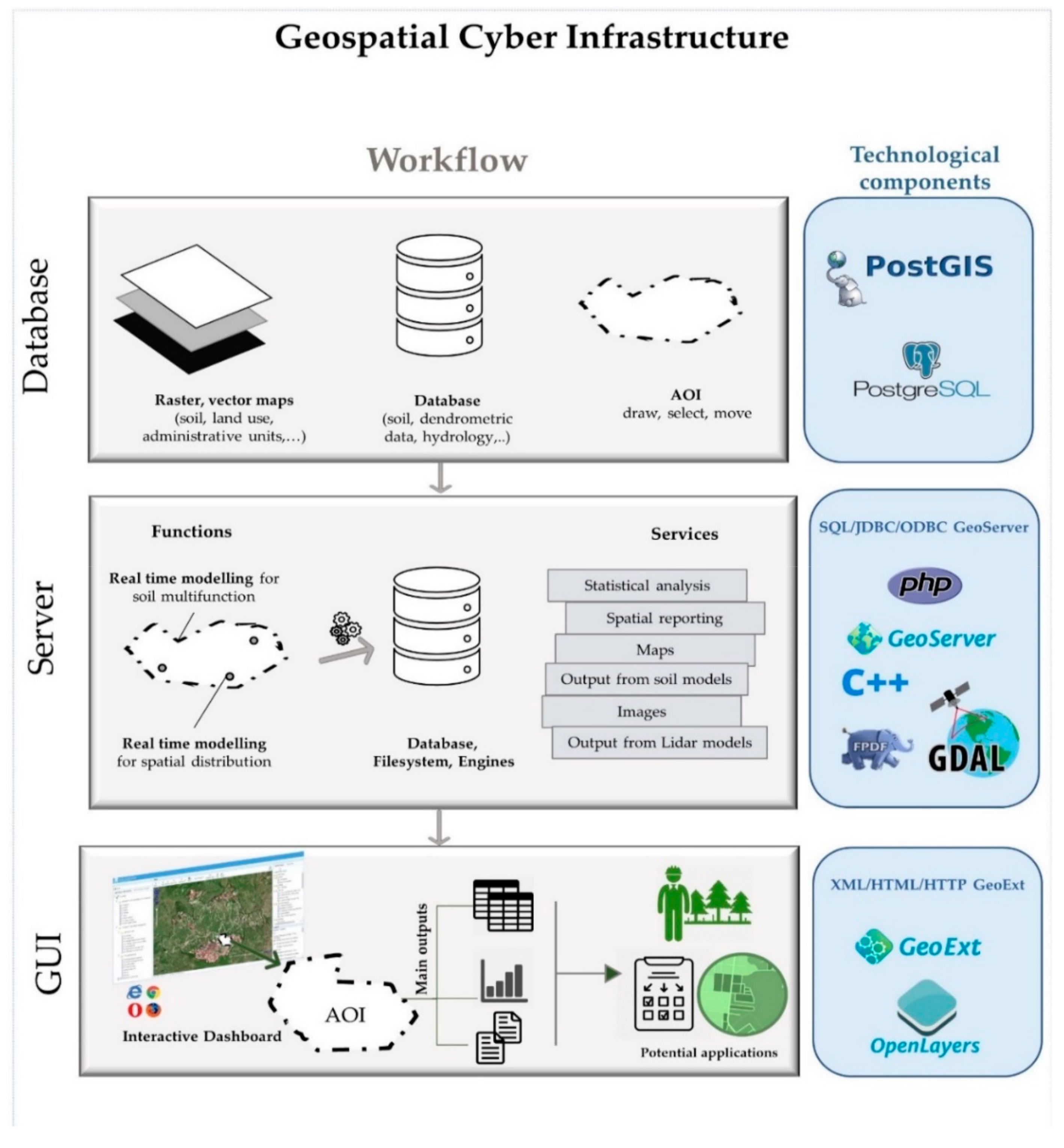
2.2. The Geospatial Cyber-Infrastructure

Through SOILCONSWEB the users can interact with digital maps and geospatial data through an open source web platform, in real time. The GCI platform belonging to the family of Geospatial Cyber-Infrastructures (GCI), uses free open-source geospatial libraries and programs and can thus support the acquisition, storage, management and integration of both static (e.g., soil, geology, forest types distributions) and dynamic data (e.g., daily climate, forest management), data visualization, and computer on-the-fly applications (such as those enabling simulation modelling). Details on the functionalities and methodological issues can be found in Terribile [29]. A scheme of the platform functionalities can be accessed by the dashboard as summarized in Figure 2. In synthesis, there is a flow of data (e.g., from geo-database) that allows the operation of different server functions (e.g., models) which produce several services accessible by the users through the dashboard. The system has a 3-tier structure in which the data management, the data processing for the applications and the data presentation are separate processes. Data management tier consists of a database in which the data are stored and retrieved in such a way as to keep information neutral and independent of application servers. Processing tier controls the application’s functionality by performing detailed processing data, and the presentation tier is delegated to displaying the information coming from processing services. This client-server communication is based on AJAX (Asynchronous Java Script and XML) technology and most of the data are transferred in JSON format. Graphs and maps are finally presented in the user interface using YAHOO Charts as a part of the ExtJS library.

2.3. Dataset

The dataset connected to the GC-I forestry Web tool includes geo-referenced data and metadata from different sources (Table 1). The main types of data include: (i) thematic maps (with related databases) in form of polygon or grid data related to soil and geology, land uses, forest types, bioclimatic and biodiversity indexes; (ii) data from specific field survey activities (e.g., soil hydrology, chemical and physical properties), (iii) simulation modelling (e.g., soil water balances). In order to allow location queries (run in SQL), before being integrated into the geospatial database, all spatial data, namely vector and raster layers, were checked for anomalies and, if required (i.e., lower resolution data for specific application) subjected to up-scaling procedures. Land use maps having different code classes (see SOILCONSWEB project [29]) were harmonized in order to be comparable and applicable for land use change analysis over time. Point data, such as those generated from soil sampling campaigns, and derived data were firstly checked for anomalies (i.e., spatial coordinates, missing data, outlier, etc.) and then loaded into the geospatial database.

2.4. LiDAR Data

Currently, Airborne Laser Scanner technology represents one of the most promising and effective innovation for a wide range of forestry applications, in particular, it allows a valuable estimation of above-ground biomass [16,39]. Within SOILCONSWEB activities, discrete-return aerial LiDAR data, collected during 2011 leaf-off condition were used to distinguish forest stand parameters and structural diversity in the study area. A detailed methodological overview of the adopted procedures for LiDAR-derived vegetation indexes computation as well as non-parametric bootstrap resampling methods [40] used to validate the regression models of LiDAR metrics vs. field data can be found in Teobaldelli [37].

3. Results

The forestry tool developed in the framework of the GCI was firstly designed as an informative decision-making process to share relevant knowledge related to the forest resources between the main stakeholders and therefore, as envisaged by the forestry laws of the Campania Region (Italy), to support future forest management activities within the study area.

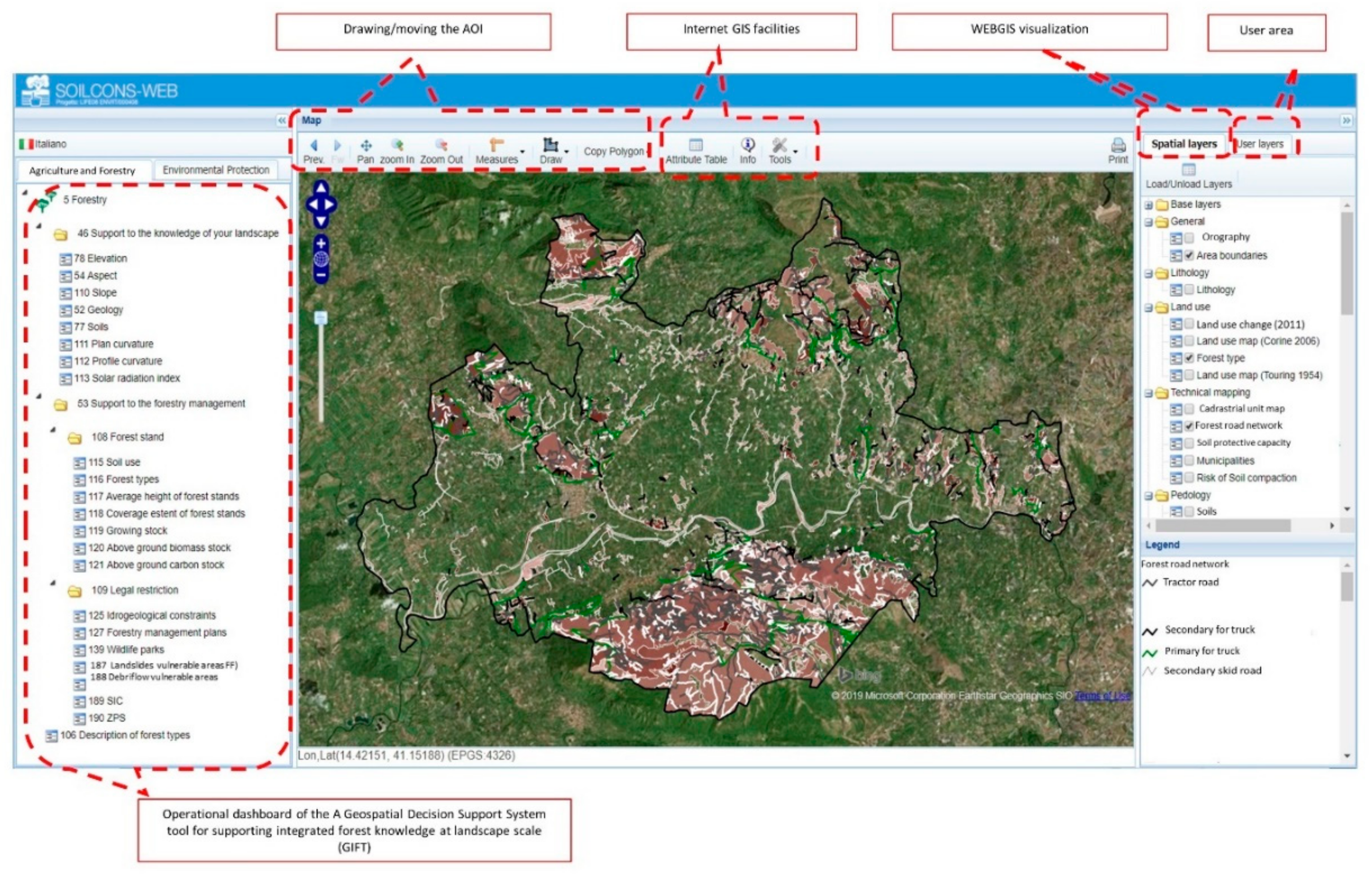
3.1. Dashboard and Basic Functions

The SOILCONSWEB S-DSS dashboard was the result of multiple interactions between expert, end-users and stakeholders (e.g., forestry, regional policymakers, private forest owners) who requested the incorporation of thematic facilities that could be strategic for forest knowledge and forest management planning. After long public concertation, this iterative feedback-driven methodology led to the development of a GUI (Graphical User Interface) that could meet the needs of the multiple S-DSS users within different fields (agriculture, forestry, land planning, etc.). Its main final structure included graphical tools and procedures to combine—on-the-fly—analysis and visualization of spatial data and subsequent production of maps and tables.
Basically, dashboard consists of five sections (Figure 3):
(i)
a dedicated area where user’s queries are recorded;
(ii)
web GIS facilities which enable the user to navigate through spatial data layers, make queries, carry out spatial statistics and other requests;
(iii)
drawing/selection of the area of interest (AOI);
(iv)
dashboards for the Geospatial forestry tool.
Since offices of the Campania Region located nearby the study area were among the main stakeholders of the dashboard and considering that in some cases, due to funding and legal restrictions, they cannot easily access desktop GIS facilities, a specific module (point (ii) as given above) was designed to allow public access to territorial information at several scales and freely make queries on the geo-database, as for instance displaying changes on land use occurred from 1950 on a selected forest area. The users (e.g., forest manager) could, for example, select pre-build AOI (above-mentioned point (iii)) within a region of interest according to their specific needs (e.g., areas to be harvested according to forest plans criteria) and therefore launch the application (the possibility of selecting specific Cadastral ID number is also given). The system allows the creation and editing/deleting of one or more polygons (that can also be moved or resized within the project area); once drawn, the AOI represents key data stored in a database and linked to the user that can therefore decide to store them in a personal hidden space or made public for general use. The forestry tool core can be found in the application dashboard and it addresses forestry management planning tasks to be performed according to end-users’ necessities.
The contribution to forest management given by GIFT is based on LiDAR-derived information that has been combined, by forest practitioners, with expert-based knowledge of the forest resources and regulation application, aimed at orienting the future evolution of the resource taking into account the owner’s necessities.
To separate the main domain of forestry interest, the forestry tool dashboard has a hierarchical structure with three main categories chosen on the basis of multiple interactions with stakeholders:
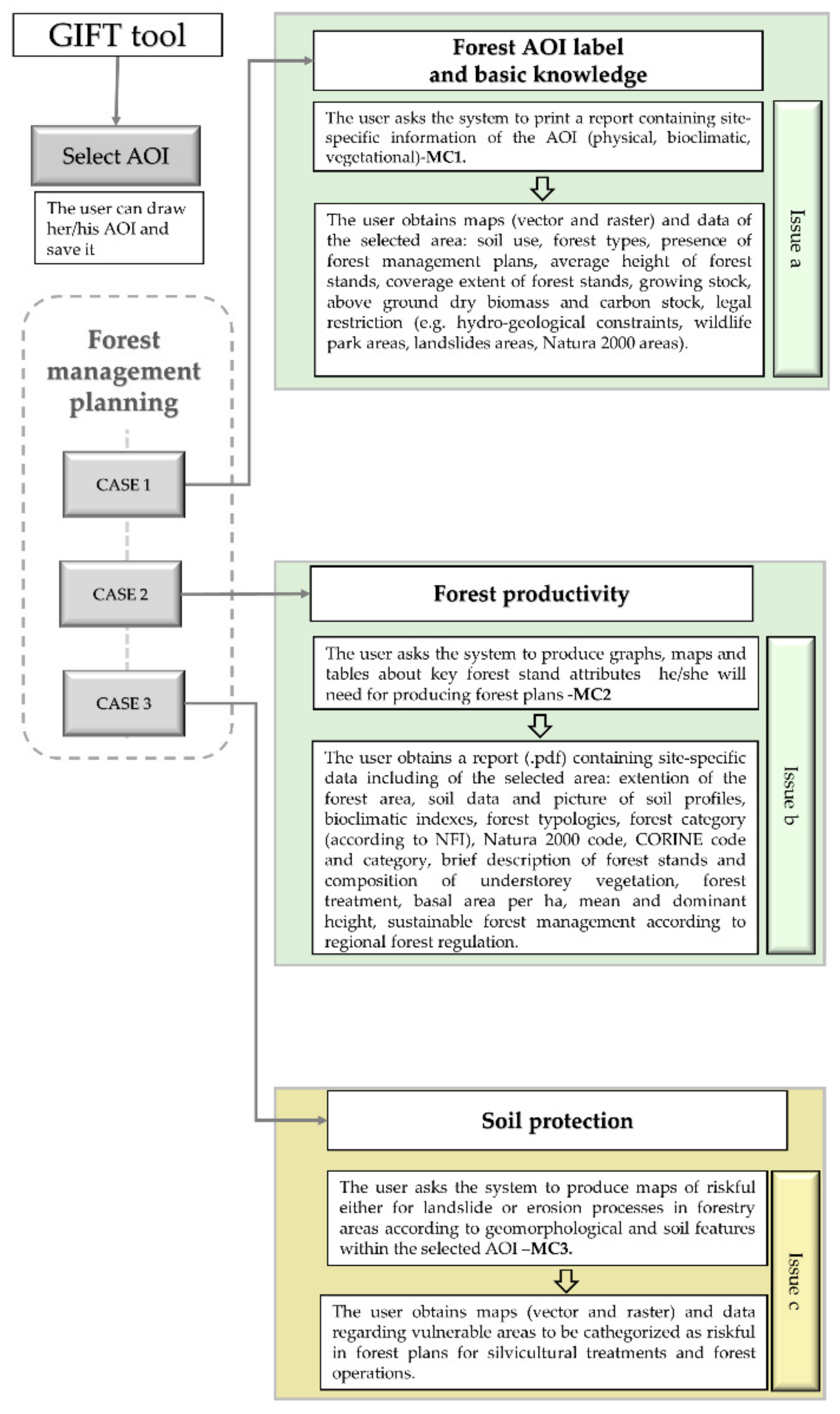
  • Forest management planning for basic knowledge: it includes applications for the description of the forest area chosen by the end user. The user selects a forest area (i.e., draws the AOI boundaries) and gets from the system a report (i.e., a real time automatically generated.pdf file) describing the main geological, climate, soil and land use features of it together with a description of the main forest typologies and stand structure features and other LiDAR-derived information regarding the soil morphology (plan and profile curvature).
  • Forest management planning for forest productivity: specific contribution referring to forest management applications by means of classical approaches: (i) in field and LiDAR-derived dendrometric measurements; (ii). the prevailing functions and the relative priority planning designation (protective, naturalistic, productive, free evolution); (iii) the ecosystem services (supply, regulation, support and cultural); iv) the sustainable forest management guidelines that refer to the type of management towards which it would be appropriate to address the typological unit. There will not be any consideration to management issues related to forest disturbances like wildfire, avalanches, pest control. The tool has been so far conceived in a simplified shape as to provide an easy and preliminary support to end-user to be guided in the fulfilment of the management plans requests by regional laws. Most applications in forestry tool apply statistical models for the production of reports (mean, max, min, standard deviation, etc.), and spatial processing routines to calculate main parameters over time within specific AOI (i.e., potential solar radiation, LiDAR-derived vegetation indexes).
  • Forest management planning for soil protection: GIFT includes a specific module on soil protection as requested by the competent authority and forest private owners.
In order to describe our physically based and empirical models we aggregated them into a modular scheme named modelling cluster (MC). The employed modelling clusters available in the forestry tool are described below and reported in Table 2.
The original Italian version of the dashboard has a slightly different labelling with a dichotomic distinction between planning and management (Figure 3) because this classification was requested by forest practitioners according to the Campania regional forest law.

3.1.1. MC1—Reporting Forestry Key Parameters for Basic Forest Knowledge

This module incorporates basic procedures used for the basic knowledge of forest resources within the area of study. It consists of two main procedures: (i) spatial statistics within the AOI on either/both vector and raster base; (ii) report making (exportable.pdf file) containing statistics and other information in table format. PostGis functionalities enable to define the analysis of the raster or vector layers stored in the geo-database in relation with the operation chosen by the user. The production of automatic PDF-report incorporates data from spatial layers relevant for forest management planning. Among them: landscape features (e.g., digital elevation model, geology and soil and forest types maps, etc.) and average climatic features (e.g., precipitation, temperature and solar radiation maps). The module operates by: (i) “clipping” the layers using the AOI as forest area; (ii) calculating pixel-based zonal statistics (min, mean, max); (iii) building the.pdf file in tabular format by reporting data thanks to the free PDF generator (FPDF). Additional routines are applied in order to include useful information in the report such as pictures of soil profiles corresponding to soil types typically spatially associated with the AOI. Soil and climate input data stored in the geo-database are “picked up” by automatic routines allowing the application of the model throughout the study area. Climate data in the DSS can be accessed through the territorial themes.

3.1.2. MC2—LiDAR Models and Vegetation Indexes Spatialization within Forest Areas at Landscape Scale

According to expert-based evaluation, eight forest typologies, overall representing ~98.3% of the entire forested area of the Telesina Valley, were identified by photo-interpretation of digital orthophotos (more details in Teobaldelli [37]); main dendrometric parameters (diameter at breast height, mean height, basal area), obtained within 26 georeferenced plot areas from ground field surveys, were used to estimate growing stock volume and merchantable and total above-ground biomass through allometric equations [41]. Eight linear models were used to predict better estimation of several dendrometric parameters including mean stand height (Hm), growing stock volume (V) and total above-ground biomass (AGB), as a function of several LiDAR metrics (estimated using the FUSION software; [37]) within the 26 georeferenced plot sampling areas. The linear equation model provided the best estimation for the selected dendrometric parameters (more detail in [37]. On the basis of the data obtained, all the information was spatialized on all the 8 forest typologies (5477.55 ha) of the study area and, finally, maps were created and exported as raster data. The module outputs consist in the production of graphs and maps related respectively to canopy cover (%), mean stand height (m), growing stock volume of stem and branches (m3 ha-1), total above-ground dry biomass (kg ha-1) within the specific AOI defined by the user.

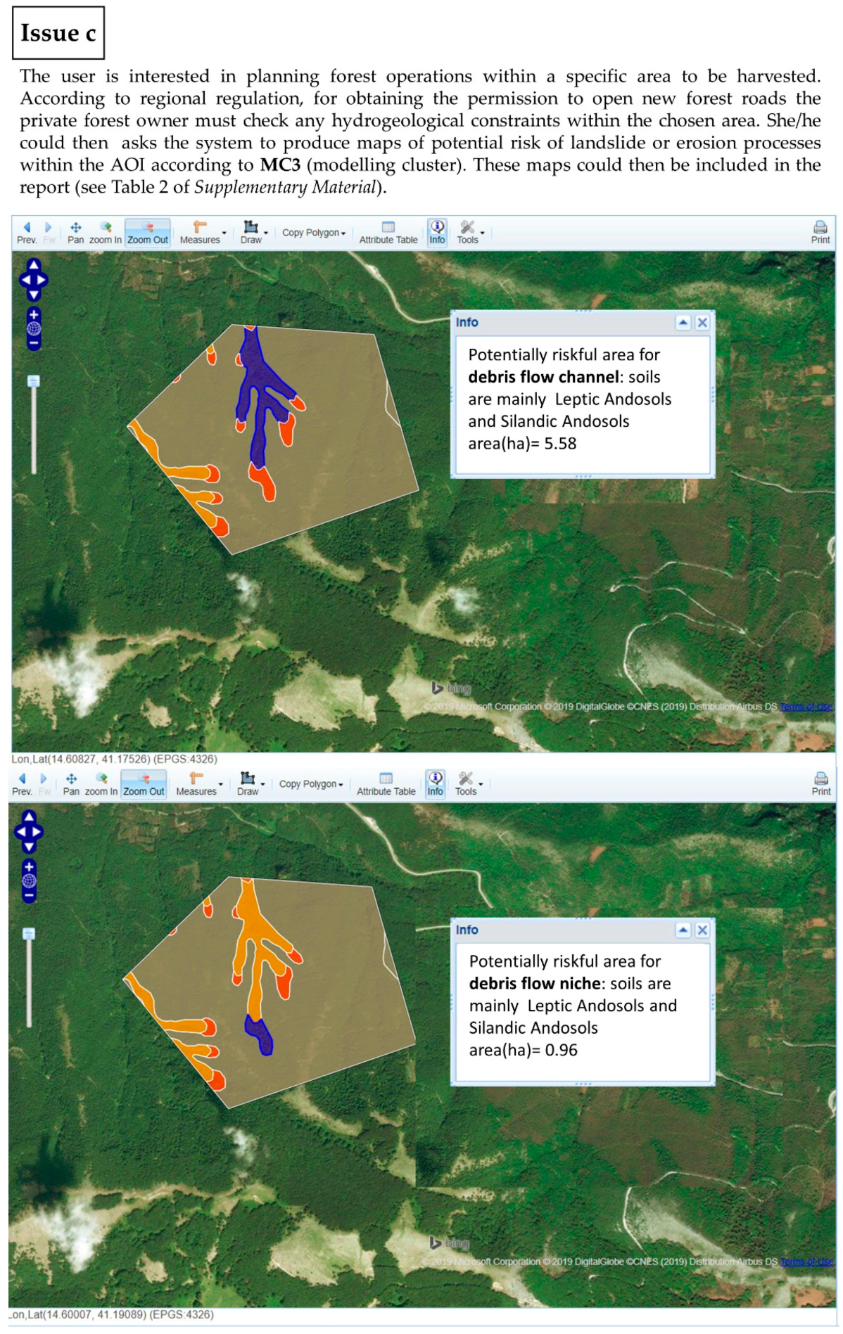
3.1.3. MC3—Soil Protection

This module provides some basic knowledge about soil protection in forest ecosystems. It consists of two main assessments: (i) potential soil erosion; (ii) potential landslide initiation. The importance of these modelling clusters refers to the evidence that forest soils of the area (mainly Silandic, Mollic, Eutrosilic Andosols, and Vitric Phaeozem) have a generally high silt content (above 60%), high vertical physical soil horizon discontinuities, very high-water retention, low adhesion towards the bedrock, high thixotropy. All above features make these soils extremely fertile and very prone towards erosion and fast mud flows/debris flows [42,43,44,45]. This condition is worsened when soil continuity is interrupted [46] by roads, cliffs and forest tracks due to forest operations. Thus, this module enables users to navigate between forest cover, forest management (e.g., tracks) soil erosion and fast mudflows. Once the user selects or creates an AOI the soil erosion module can calculate the potential soil erosion after the RUSLE approach [47] thus combining the following factors: rainfall-runoff erosivity, soil erodibility, slope length, slope steepness, cover-management and support practice. The model includes a “what if” approach; for instance, the user can evaluate—in real time—how far potential soil erosion can be reduced after adopting new cover (canopy density). In the case of the landslide tool, the user can access the system to know the selected forest AOI and the specific connection between soil type and landform with an estimate of the mudflow risk classification.

3.2. Case Studies

The forestry tool developed within SOILCONSWEB was applied to an inland area of the southern Apennines which was highly representative of land use and forest types. The aim was to support management planning activities carried by forest owners. This support started with a preliminary recognitive analysis of forest resources through the identification of the main forest types, past and current management and silvicultural system according to forest plans, mapping of the main dendrometric parameters, display of the above-mentioned information and creation of reports. The final product for the user was represented by raster/vector maps, tables and summaries in technical sheets including the description of the station (soil, slope, exposure), forest types, presence of eventual sites of community interest, suggested management techniques (i.e., silvicultural system) defined within the areas of interest chose by the end-user. From an operational point of view, we chose to divide the cases of application into three domains, all part of forest management planning: basic knowledge of forest resources, management planning for forest production and management planning for integrated soil protection. We consider GIFT a full functional management planning tool providing forest experts with support during planning processes. Figure 4 depicts the various steps the user had to follow to obtain the desired output information.

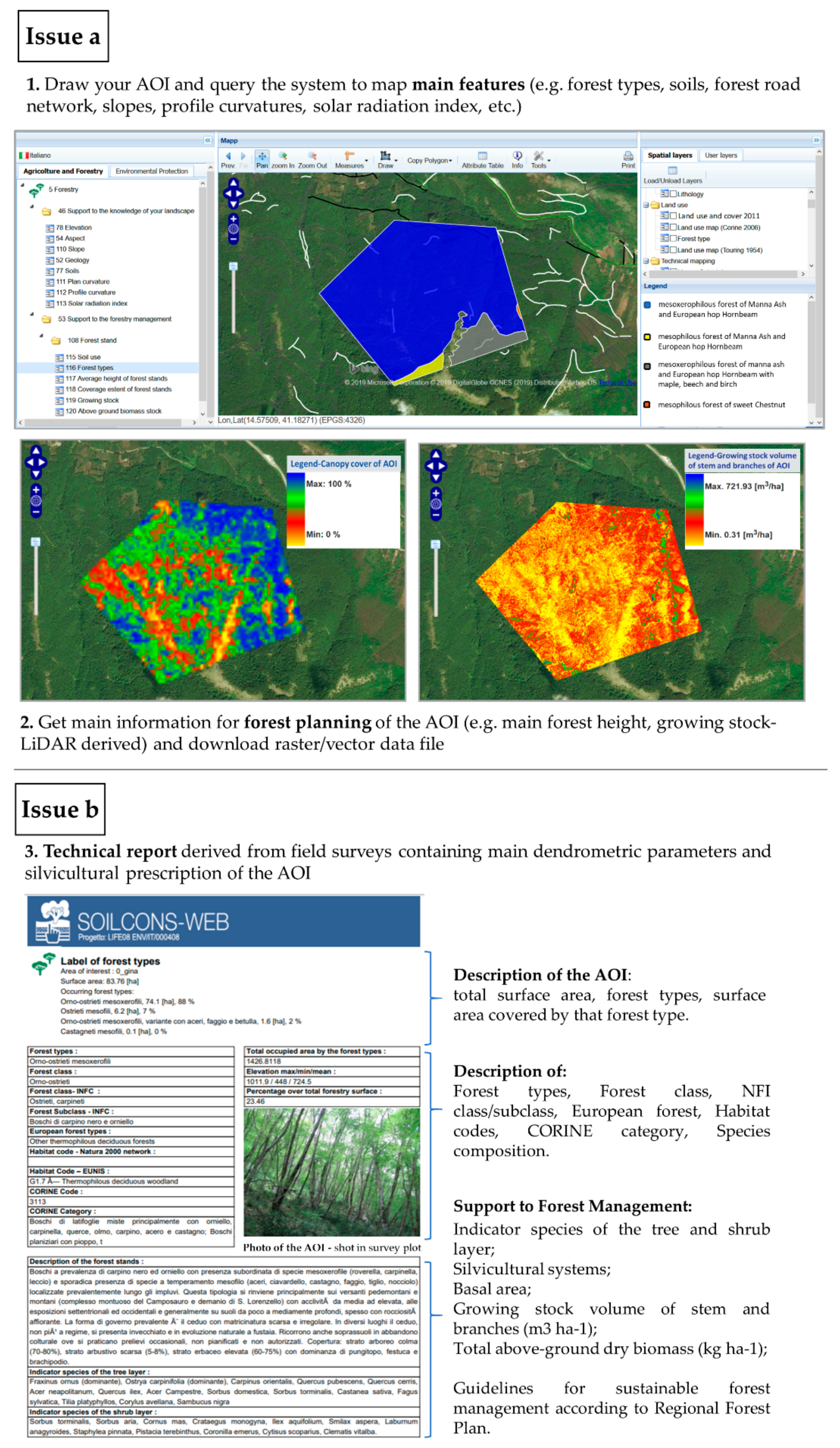
3.2.1. Case 1: Support to Management Planning for Basic Forest Knowledge

Regional forest planning in Campania Region, Italy [48] (named from now on RR) is divided into the following planning levels: a. General- General Forestry Plan; b. Executive- Forestry Planning Executive Document; c. local- including the Territorial Forestry Plan (PFT) and the Forest Management Plans (PGF). The here proposed GIFT tool has the full potential of providing support both to forest planners, as it offers fact-finding survey of the forest resources, and to private forest owners in the cutting series plan. The General Forestry Plan actualization is formalized by Forest Management Plans [49]. Private forest owners who typically want to cut a specific forest parcel/lot must submit an authorization request or a communication to the Mountain Community (Mc, Provincial Administration (PrA), Metropolitan City (MeC) where the lot to be cut falls, using one of the models [48] as appropriate. For both these applications, the forestry tool can be used for collecting basic forest data within a specific AOI.
Indeed, the proposed procedure can be employed by end-users who are interested in:
(i)
getting information, that are typically not easily available, related to forest types and quantitative stand attributes of a specific AOI, with the purpose of providing additional information for assisting planning phase of the chosen forest area. Of course, more detailed and complete information at stand scales regarding stand density, tree height and diameter distribution and average stand age must be performed with field surveys. The above-mentioned tasks are performed by applying the MC1 routine;
(ii)
having a support for identification of higher growing stock areas;
(iii)
evaluate whether some key environmental factors could ease forest operations. More specifically, a user can “explore” her/his AOI (Figure 5) by evaluating some environmental factors (DTM, profile curvature, soil, and forest types) that might facilitate the study of forest areas and its main silvicultural and environmental features.

3.2.2. Case 2: Support to Management Planning for Forest Productivity

This procedure can be employed mainly by private forest owners who aim at optimizing forest resources by performing cutting series plan for (Attachment 14—art. 30 c 1 letters a-b authorization for cuts in the absence of a Forest Management Plan—for public subjects; Attachment 15—art. 30 letter a, communication cuts in absence of a Forest Management Plan—private subjects).
It is stated by RR [48] that in order to harvest:
(i)
coppices (with reserves, mixed or selection) with total surfaces greater than or equal to 2 hectares and less than 10 hectares, in the absence of a Forest Management Plan;
(ii)
high forests and coppices in conversion to high forests for a total area greater than or equal to 0.5 hectares and less than 10 hectares, in the absence of a Forest Management Plan
It is compulsory, for the private forest owner, to obtain a prior harvesting authorization issued by the territorially competent delegated body (Mc, PrA, MeC). These bodies will retrieve the authorizations from the Single Desk for Forest Activities (named S.U.A.F., in Italian Sportello Unico per le Attività Forestali).
For the above-referred purposes, the owner, or other legitimately authorized person, must present a specific request in order to get a cutting authorization [50]. The request consists in a report that must contain the following information regarding: cadastral data of the forest area, total area to be harvested, classification of the territorial context in which the forest falls with the specification of any restrictions (whether present), main dendrometric parameters of the stand, etc. The entire required information that must be contained in the report according to the regional forestry law and the parameters that can be provided by the GIFT tool is available in Table S2 of Supplementary Materials.
The majority of the pre-listed information requested by forest regional regulation can be derived from the forestry tool (Figure 4 and Figure 5b) by using MC2, i.e., can plan sylvicultural treatments and harvesting operations evaluating breast height (1.3 m) tree diameter and height distribution, growing stock and above-ground biomass within different AOIs. This allows also to identify the best areas to actively manage to take a look at the areas having higher biomass indexes, better soil conditions and easy-to-access forest road network. The user can draw the AOI and immediately get the above-mentioned information and biomass data, and as the MC2 application can be repeated elsewhere in the study area (i.e., Telesina Valley) therefore obtaining several scenario analyses with, potentially a large spatial variability of the predominant environmental factors (e.g., soil properties, forest typologies, altitude, exposition, etc.). Even through an aggregated and simplified approach, the forestry DSS tool makes it capable to adapt to several purposes.

3.2.3. Case 3: Support to Management Planning for Soil Protection and Forest Road Evaluation

Having a tool that can inform decision-makers (Regional Forestry Office, Mc, PrA, etc.) of areas that are potentially at risk of landslides is crucial for issuing authorization procedures for forest management. These areas should be managed with special care when either silvicultural management must be performed or adjustments/opening/widening of forest roads network must be made. Indeed, the woods extraction must, by regulation, take place on existing roads, ducts and canals, avoiding rolling and logging on recently cut patches or in regeneration patches. According to the regional forest regulation and, similar to the areas subject to hydrogeological constraint, the opening of forest roads and forest tracks for logging operations is subject to prior authorization, to be requested together with the authorization for forest cutting. If an AOI falls within landslide vulnerable zones, the protective function with relative management could be assigned to that forest area, according to the regional forest regulation. It has been proved that forest tracks are in some cases correlated to landslide occurrences [46]. According to the regional forest regulation [48] the opening of roads and forest tracks for the extraction of timber is subject to prior authorization. We hypothesized that if a private forest owner’s needs to cut a patch of coppice and open new forest roads, before submitting the relative authorization to Campania Region Forest officers, might perform a preliminarily self-assessment of the area using the MC3 of the forestry DSS tool as shown in Figure 6. By doing so, it would be possible for the private forest owner to check the susceptibility of the AOI to be managed and therefore, according to the results obtained, provide extra elements to the documentations that will be finally subjected to the authorization of the public authority.

4. Discussion

In this paper, we present the product, developed within the SOILCONSWEB Life project, named GIFT tool that has been conceived as a Geospatial decision support system tool for supporting Integrated Forest knowledge at the landscape scale. This tool was the result of a bottom-up consultation process that involved researchers and stakeholders in the field of forestry who were asking for an easy-to-use, friendly and open-access geospatial web-based decision system to support forest resources knowledge in a holistic and integrated way. Through this GCI we attempted to build a prototype that might represent a new way ahead for providing a multi-user and multiscale forest tool ranging from single forest parcel to district (13 municipalities) level.

4.1. Future Prospects

GIFT represents an attempt of sharing knowledge in the framework of functional although in a simplistic way, when data availability in the forestry sector and regional regulation hardly convey into forest management planning. Given the need for an operational tool to be operational, here we try to summarize some of the main achievements that might help to shape future forest S-DSS development.
Among the positive acknowledgments we name:
  • The multifunctional approach as push into wood market; We know that forests are part of an integrated and much wider sustainable framework. Indeed, forestry is connected to other land uses: accordingly, this can be turned into practice by end-users (e.g., forest owner) by querying information regarding main soil threats or land use changes over a desired time-lapse within the AOIs. The forestry tool here developed contains also an innovation giving special emphasis on applied soil knowledge. The forest knowledge could potentially, even if indirectly, help wood products market development in Campania Region. In fact, farmers/private forest owners believe that obtaining easy to interpret data of forest productivity (biomass) for a specific AOI might awaken the knowledge of the available forest resources of their territory, making it possible to affect especially the price of firewood in the area;
  • The simplicity behind a bottom-up product. The system allows forest owners/forest technicians to draw their own forest area and get information strictly dedicated to their specific territory. Such a simple query was perceived as an innovative tool to get quick and easy to ready information of forest areas of interest; The feedback given by end stakeholders, through face-to-face meetings and interviews, have been fundamental for the development and management of this platform;
  • WOG (web, open, geospatial). In a more general theme, the key and crucial aspect of this paper refer to the importance of using free, open-source geospatial libraries and programs allowing the potential involvement of a large community of developers, including the processing of data/models from different sources and formats;
  • Soil supports forest planning according to silvicultural types; The GIFT tool represents a first attempt of supporting forest planning in a Region of the southern Apennines where coppice stands mainly occupy slopes and cover 42% of the forest surface [51]. Their periodical cuttings (on average every 14–18 years) imply environmental impacts at local and landscape scales. As stressed in MC3—Soil application section, superimposed allochthonous soils from volcanic origin are widespread in the Campania Region.

4.2. The Innovation of GIFT in the Framework of Forest S-DSS

The SoilConsWeb, under which GIFT has been developed, is a complex GCI, as depicted in Figure 2, whose main features are (i) the use of open source technologies aimed at building (ii) a freely available web application enabling (iii) geospatial analysis possibly (iv) on the fly.
It this sense, GIFT takes its shape in the framework of landscape management, altogether with other land uses tools with which it is intimately linked (e.g., Digital Soil Mapping (DSM) and soil-plant-atmosphere engines (SPA) DSM information and SPA models are interconnected between the different land-uses).
There is a major cost in the initial design and the further implementation of such a platform, but here we want to highlight the possibilities that such system can offer when compared to the more traditional Forest DSSs.
The majority of the already developed forest DSS consists of standalones systems with a closed source software [9,31] to be installed on local computers, designed for individual or specific use. In many cases, the user has to deal with issues related to the installation process—including the operative system requirements and the installation of prerequisites—and to further maintenance, such as updates of the operative system hosting the DSS software or the update of the DSS software itself. On the other hand, when web-based systems are available these are eventually not covering geospatial analysis.
The SoilConsWeb platform is maintained in a centralized way: software components can be easily updated (in particular those thirds parties open source components, such as GeoServer), the hardware can be upgraded to raise physical resources and navigation performance and compatibility issues can be fixed without leaning on the end user contribution.
The GCI platforms, like GIFT, compared to more traditional forest DSS are more adaptable to be transferred to larger areas moving towards its application on a landscape scale turning appealing also in terms of cost reduction. The GCI is flexible enough that a new tool can be easily added to the toolbox. Indeed, this operation is simple both on server side (to be performed by the administrator) as well as on the client side where only a quick web page refresh is required. This last facilitation was useful during the interaction with stakeholders which led to the frequent modifications of existing tools or creation of new ones. The platform can be navigated also by smart devices (phones and tablets) that have access to the internet connection, and this enhance the portability of the tools even in the case a login is required. One disadvantage might be the web browser compatibility, but the most widespread browsers are fully compatible, such as Mozilla Firefox and Google Chrome. Another limitation is the internet connection: without connection or in case of low bandwidth, there is no chance to properly use the DSS.

4.3. Limitations of the GCI and Further Development

Some major and challenging problems have been identified during the building process of the GCI and these should as well lead further development of the GIFT tool and of forest S-DSS in general.
First of all, no forest models for simulating silvicultural practices have been yet developed or applied within the GIFT, nevertheless further developments are required and crucial for such CyberInfrastructure. Indeed, according to the experience gained within SOILCONSWEB projects, a framework has been established in a new follow-up platform to be built under the LANDSUPPORT project funded by the European Union’s Horizon 2020 Framework Program for Research and Innovation (H2020-RUR-2017-2). Simulated silvicultural treatments through process-based models (PBMs) will be performed at local and regional level, taking into account forest structure complexity and soil properties in integrated Forest Ecosystem Models (FEMs). The 3D-CMCC-FEM model [52] will be implemented in LANDSUPPORT and will investigate different forest management option according to climatic scenarios including biomass pools and their partitioning, for complex multi-layer forests [52,53,54].
Due to lack of homogeneous and detailed information, no socio-economic data was taken into account to estimate, measure and test the potential impact that the tool could have within the study area. We would strongly recommend integrating economic information in S-DSS and similar forestry tools to give it a solid economic dimension for encouraging an active management of the forest resource. In this case, an interesting approach can be found in a novel Spatially-based Economic Model tools for estimation of the harvesting cost of logging [55].
We must further stress that data availability and upgrade are crucial for a robust assessment of the parameters of interest (especially biomass). Nevertheless, field and LiDAR-derived data of the forest areas actually displaced on the platform refer to 2011 measurements and have not been refreshed or updated ever since.
Despite many forest DSS also process time-series data such as meteorological variables [56] and others [57,58,59,60] have been developed having as main focus the effects of different climate change scenarios on CO2 assimilation or on forest disturbances such as the growing risk of drought, forest fire, wind damages and bark beetle outbreaks [20,61,62,63,64] this DSS does not take these issues into account because within the study area they were not expressly demanded by stakeholders.
The users cannot upload his/her own data (ktm files, dendrometric surveys) into the forestry tool to customize their AOI.
The Regional Forest Office of Campania Region, stakeholder of the project, does not possess a Forest Territorial Information System and this absence weakens the web geospatial DSS and the forestry tool. We believe that a technical connection between the two systems could be possible and could enhance forest resources management and data harmonization at a regional level. Application over larger areas would be fundamental to support forest regional planning.
Sensing implementation: using proximal sensing could allow a climate change scenario trend analysis, but reliable daily climate data collected by the Region at suitable scales are absent. A further investment on data obtained on further LiDAR flights it would be useful.
Application at larger extent areas than the present work is highly desirable to support forest planning at district and regional scales. In order to face this challenge it would be crucial to address: (i) more investments to be performed by the public authority on data assimilation by means of LiDAR on the whole region; (ii) a proper and formalized reliability/quality of the input data and the resolution of the information provided at a large spatial scale; (iii) the need of high-performance computing systems to process in real time large amounts of data.
At last, we must stress that the potential deliveries of the forest tool are very fragile if good maintenance of the system components is not guaranteed.

5. Conclusions

Getting access to forestry, agriculture, environment, and urban planning data is nowadays of undiscussed importance for they are the starting point to support best decisions/practices for management issues. Overall, we think that in the domain of S-DSS, many of these systems can fail in their mission and these failures are often related to the development of many complex systems which are both difficult to operate and difficult to modify [65]. DSS may be designed for a particular problem, supporting a specific decision process or just a decision-making phase or they may be general and adaptive to fit a range of decision problems and processes [7]. Beyond the different procedural approaches to decision-making, it is obvious that a single decision support tool will not be sufficient to cover all needs of all decision-makers and stakeholders [59]. Nevertheless, we strongly suggest that producing many forest S-DSS systems each one adapted to a specific site it is not a good solution. Since there is an increasing demand for the development of land use planning concertation tools, we believe that the development of operational open-source and multipurpose S-DSS tools for end-users (farmers, forest owners, policymakers) can help address the complexity of the landscape in starting from an easy-to-handle tool capable of providing stakeholders with an immediate and effective basic knowledge of the territory they live in and its resources. Indeed, spatial analysis and open-source platform make it possible to stakeholders to be engaged in the decision-making processes and being no longer exclusive to GIS experts. For this reason, our platform has also been designed to encourage the use by multiuser community (from farmers, forestry owners to public bodies like policymakers). Such a platform is consistent with the FAIR criteria and has full potential of interoperability and replicability enabling to address large spatial extent areas through the GCI platform itself. In most cases, data are not accessible but through an integrated S-DSS GCI it is indeed possible to reconcile sustainable forest planning with multifunctional landscape forest productivity (expected management). As previously stated, Campania Region does not have an easy-accessible forest web-GIS platform (Regional Forest Geographical Information System), making it difficult for end-users to access forest information of any sort. Strategic planning [66] might also benefit of this open-access forestry tool. We must conclude that the system can help overcoming current disciplinary fragmentation over landscape issues and integrate forestry in the landscape mosaic it belongs to, especially in inland mountain areas where economic progress in southern Apennines is still weak [67] helping to maintain forest ecosystem functions in the area of study [68]. We proposed a new way ahead through a smart Web-based system integrating geospatial knowledge archive to be used directly and freely by any end-user. This platform can benefit of modelling chains elsewhere developed and know-hows coming from other domains for this contamination and modularization vision can help narrowing the distances that MacIntosh et al. (2011) stated has long divided scientists and academia from end users and their concrete issues.

Supplementary Materials

The following are available online at https://www.mdpi.com/1999-4907/10/8/690/s1. Table S1: Functionalities of the FORSYS wiki software (adapt Packalen et al., 2013) and ForestDSS Wiki (last access on 27 July 2019); Table S2: Main information that must be contained in the report that the forest owner must provide to the competent authority according to the regional forest law and the related items that the S-DSS can provide him/her with.

Author Contributions

Conceptualization and methodology, F.T., G.M., C.M., A.B., A.S.; software, C.M. and G.L.; validation, M.T., F.C.; LiDAR modelling, M.T.; field investigation, F.C.; data curation, M.T., F.C., P.M.; writing—original draft preparation, G.M., F.T.; writing—review and editing, G.M., F.T., A.B, A.S.; supervision, F.T.; project administration, A.B. and F.T.

Funding

This paper has been produced in the framework in first phase by SOILCONSWEB project (LIFE08 ENV/IT/000408) and in a second phase by LANDSUPPORT Horizon 2020 research and innovation programme under grant agreement No 774234.

Acknowledgments

Authors would like to thank Alberto Mattia, Regional Forest Officer of Campania Region for his contribution to the case studies, For. Simone Valentini for digitalization of forest road network, L. Marotta and M. Colandrea for their contribution in the building of informatics infrastructures, L. Randazzo and L. Minieri for their contribution in administration activities. Furthermore, special thanks go to the LANDSUPPORT H2020 project that has received funding from the European Union’s Horizon 2020 research and innovation programme under grant agreement No 774234, for carrying on the follow-up building of a new platform on the basis of what has been done by SOILCONSWEB project. The authors are grateful for the valuable comments received, including those by anonymous reviewers, concerning the text of the manuscript which substantially improved the quality of this manuscript.

Conflicts of Interest

The authors declare no conflict of interest. The funders had no role in the design of the study; in the collection, analyses, or interpretation of data; in the writing of the manuscript, or in the decision to publish the results.

References

  1. Segura, M.; Ray, D.; Maroto, C. Decision support systems for forest management: A comparative analysis and assessment. Comput. Electron. Agric. 2014, 101, 55–67. [Google Scholar] [CrossRef]
  2. Forest Europe Resolution H1. General Guidelines for the Sustainable Management of Forests in Europe. In Proceedings of the Second Ministerial Conference on the Protection of Forests in Europe, Helsinki, Finland, 16–17 June 1993; pp. 1–5. [Google Scholar]
  3. Forest Europe Resolution H2. General Guidelines for the Conservation of the Biodiversity of European Forests. In Proceedings of the Second Ministerial Conference on the Protection of Forests in Europe, Helsinki, Finland, 16–17 June 1993; pp. 1–4. [Google Scholar]
  4. Lexer, M.J.; Brooks, R.T. Decision support for multiple purpose forestry. For. Ecol. Manag. 2005, 207, 1–3. [Google Scholar] [CrossRef]
  5. Mohren, G.M.J. Contrasts between biologically-based process models and management-oriented growth and yield models. For. Ecol. Manag. 1994, 69, 1–5. [Google Scholar] [CrossRef]
  6. Amaro, A.; Reed, D.; Soares, P. Modelling Forest Systems; 1. Forests; CABI Publishing: Wallingford, UK, 2009; ISBN 0851996930. [Google Scholar]
  7. Vacik, H.; Lexer, M.J. Past, current and future drivers for the development of decision support systems in forest management. Scand. J. For. Res. 2014, 29, 2–19. [Google Scholar] [CrossRef]
  8. Reynolds, K.M. Integrated decision support for sustainable forest management in the United States: Fact or fiction? Comput. Electron. Agric. 2005, 49, 6–23. [Google Scholar] [CrossRef]
  9. Packalen, T.; Marques, A.; Rasinmäki, J.; Rosset, C.; Mounir, F.; Rodriguez, L.C.E.; Nobre, S.R. Review. A brief overview of forest management decision support systems (FMDSS) listed in the FORSYS wiki. For. Syst. 2013, 22, 263–269. [Google Scholar] [CrossRef]
  10. Nobre, S.; Eriksson, L.-O.; Trubins, R. The Use of Decision Support Systems in Forest Management: Analysis of FORSYS Country Reports. Forests 2016, 7, 72. [Google Scholar] [CrossRef]
  11. Baskent, E.Z.; Keles, S. Spatial forest planning: A review. Ecol. Modell. 2005, 188, 145–173. [Google Scholar] [CrossRef]
  12. Rauscher, H.M. Ecosystem management decision support for federal forests in the United States: A review. For. Ecol. Manag. 1999, 114, 173–197. [Google Scholar] [CrossRef]
  13. Rauscher, H.M.; Reynolds, K.; Vacik, H. Decision-support systems for forest management. Comput. Electron. Agric. 2005, 49, 1–5. [Google Scholar] [CrossRef]
  14. Twery, M.J.; Knopp, P.D.; Thomasma, S.A.; Rauscher, H.M.; Nute, D.E.; Potter, W.D.; Maier, F.; Wang, J.; Dass, M.; Uchiyama, H.; et al. NED-2: A decision support system for integrated forest ecosystem management. Comput. Electron. Agric. 2005, 49, 24–43. [Google Scholar] [CrossRef] [Green Version]
  15. Orazio, C.; Montoya, R.C.; Régolini, M.; Borges, J.G.; Garcia-Gonzalo, J.; Barreiro, S.; Botequim, B.; Marques, S.; Sedmák, R.; Smreček, R.; et al. Decision support tools and strategies to simulate forest landscape evolutions integrating forest owner behaviour: A review from the case studies of the European project, INTEGRAL. Sustainability 2017, 9, 599. [Google Scholar] [CrossRef]
  16. Corona, P.; Chianucci, F.; Quatrini, V.; Civitarese, V.; Clementel, F.; Costa, C.; Floris, A.; Menesatti, P.; Puletti, N.; Sperandio, G.; et al. Precision forestry: Concepts, tools and perspectives in Italy. For. Riv. Selvic. Ecol. Ed. For. 2017, 14, 1–12. [Google Scholar] [CrossRef]
  17. Nolè, A.; Collalti, A.; Borghetti, M.; Chiesi, M.; Chirici, G.; Magnani, F.; Marras, S.; Maselli, F.; Sirca, C.; Spano, D.; et al. The role of managed forest ecosystems: A modeling based approach. Environ. Sci. Eng. 2014, 131, 71–85. [Google Scholar]
  18. Puletti, N.; Floris, A.; Scrinzi, G.; Chianucci, F.; Colle, G.; Michelini, T.; Pedot, N.; Penasa, A.; Scalercio, S.; Corona, P. CFOR: A spatial decision support system dedicated to forest management in Calabria. For. Riv. Selvic. Ed. Ecol. For. 2017, 14, 135–140. [Google Scholar] [CrossRef]
  19. Prandi, F.; Panizzoni, G.; Magliocchetti, D.; Devigili, F.; De Amicis, R. WebGL virtual globe for efficient forest production planning in mountainous area. In Proceedings of the 20th International Conference on 3D Web Technology, Heraklion, Greece, 18–21 June 2015; pp. 143–151. [Google Scholar]
  20. Kašpar, J.; Bettinger, P.; Vacik, H.; Marušák, R.; Garcia-Gonzalo, J. Decision support approaches in adaptive forest management. Forests 2018, 9, 2–5. [Google Scholar] [CrossRef]
  21. Van Orshoven, J.; Gilliams, S.; Muys, B.; Stendahl, J.; Skov-Petersen, H.; Van Deursen, W. Support of Decisions on Afforestation in North-Western Europe with the AFFOREST-sDSS. Environ. Eff. Afforest. North-Western Eur. 2007, 227–247. [Google Scholar] [CrossRef]
  22. Vacik, H.; Lexer, M.J. Application of a spatial decision support system in managing the protection forests of Vienna for sustained yield of water resources. For. Ecol. Manag. 2001, 143, 65–76. [Google Scholar] [CrossRef]
  23. Lubello, D. University of Padua a Rule-Based Sdss for Integrated Forest Harvesting Planning. 2008. Available online: http://paduaresearch.cab.unipd.it/262/ (accessed on 14 August 2019).
  24. Sacchelli, S.; Zambelli, P.; Zatelli, P.; Ciolli, M. Biomasfor: An open-source holistic model for the assessment of sustainable forest bioenergy. IForest 2013, 6, 285–293. [Google Scholar] [CrossRef]
  25. Sacchelli, S. A decision support system for trade-off analysis and dynamic evaluation of forest ecosystem services. IForest 2018, 11, 171–180. [Google Scholar] [CrossRef]
  26. Vacik, H.; Lexer, M.J.; Scholz, J.; Wolfslehner, B.; Marie, A. Design and use of computer-based tools supporting forest planning and decision making in Austria. Rep. Cost Action FP 2014, 804, 16–32. [Google Scholar]
  27. Kirilenko, A.; Chivoiu, B.; Crick, J.; Ross-Davis, A.; Schaaf, K.; Shao, G.; Singhania, V.; Swihart, R. An Internet-based decision support tool for non-industrial private forest landowners. Environ. Modell. Softw. 2007, 22, 1498–1508. [Google Scholar] [CrossRef]
  28. Bhargava, H.K.; Power, D.J.; Sun, D. Progress in Web-based decision support technologies. Decis. Support. Syst. 2005, 43, 1083–1095. [Google Scholar] [CrossRef]
  29. Terribile, F.; Agrillo, A.; Bonfante, A.; Buscemi, G.; Colandrea, M.; Antonio, A.D.; De Mascellis, R.; De Michele, C.; Langella, G. A Web-based spatial decision supporting system for land management and soil conservation. Solid Earth 2015, 7, 661–709. [Google Scholar] [CrossRef]
  30. Bettinger, P.; Boston, K.; Siry, J.P.; Grebner, D.L. Chapter 1—Management of Forests and Other Natural Resources. In Forest Management and Planning, 2nd ed.; Bettinger, P., Boston, K., Siry, J.P., Grebner, D.L., Eds.; Academic Press: Cambridge, MA, USA, 2017; pp. 1–20. ISBN 978-0-12-809476-1. [Google Scholar]
  31. Borges, J.G.; Nordstrom, E.M.; Garcia-Gonzalo, J.; Hujala, T.; Trasobares, A. Computer-based tools for supporting forest management. The experience and the expertise world-wide. For. Manag. Decis. Support. Syst. 2014, 2014, 3–15. [Google Scholar]
  32. Modica, G.; Pollino, M.; Lanucara, S.; La Porta, L.; Pellicone, G.; Di Fazio, S. Computational Science and Its Applications. ICCSA 2013, 7975, 399–413. [Google Scholar]
  33. Terribile, F.; Bonfante, A.; D’Antonio, A.; De Mascellis, R.; De Michele, C.; Langella, G.; Manna, P.; Mileti, F.A.; Vingiani, S.; Basile, A. A geospatial decision support system for supporting quality viticulture at the landscape scale. Comput. Electron. Agric. 2017, 140, 88–102. [Google Scholar] [CrossRef]
  34. Piero, M.; Angelo, B.; Antonello, B.; Amedeo, D.; Carlo, D.M.; Michela, I.; Giuliano, L.; Florindo, M.A.; Paolo, P.; Simona, V.; et al. Soil Sealing: Quantifying Impacts on Soil Functions by a Geospatial Decision Support System. L. Degrad. Dev. 2017, 28, 2513–2526. [Google Scholar] [CrossRef]
  35. Wilkinson, M.D.; Dumontier, M.; Aalbersberg, I.J.; Appleton, G.; Axton, M.; Baak, A.; Blomberg, N.; Boiten, J.W.; da Silva Santos, L.B.; Bourne, P.E.; et al. Comment: The FAIR Guiding Principles for scientific data management and stewardship. Sci. Data 2016, 3, 1–9. [Google Scholar] [CrossRef]
  36. McIntosh, B.S.; Ascough, J.C.; Twery, M.; Chew, J.; Elmahdi, A.; Haase, D.; Harou, J.J.; Hepting, D.; Cuddy, S.; Jakeman, A.J.; et al. Environmental decision support systems (EDSS) development—Challenges and best practices. Environ. Model. Softw. 2011, 26, 1389–1402. [Google Scholar] [CrossRef]
  37. Teobaldelli, M.; Cona, F.; Saulino, L.; Migliozzi, A.; D’Urso, G.; Langella, G.; Manna, P.; Saracino, A. Detection of diversity and stand parameters in Mediterranean forests using leaf-off discrete return LiDAR data. Remote Sens. Environ. 2017, 192, 126–138. [Google Scholar] [CrossRef]
  38. EEA. European Forest Types; EEA: Copenhagen, Denmark, 2007. [Google Scholar]
  39. Laurin, G.V.; Puletti, N.; Chen, Q.; Corona, P.; Papale, D.; Valentini, R. Above ground biomass and tree species richness estimation with airborne lidar in tropical Ghana forests. Int. J. Appl. Earth Obs. Geoinf. 2016, 52, 371–379. [Google Scholar] [CrossRef] [Green Version]
  40. Efron, B. Bootstrap Methods: Another Look at the Jackknife Annals of Statistics 7: 1–26; Springer: New York, NY, USA, 1979. [Google Scholar]
  41. Tabacchi, G.; Di Cosmo, L.; Gasparini, P.; Morelli, S. Stima del volume e della fitomassa delle principali specie forestali italiane. Equazioni di previsione, tavole del volume e tavole della fitomassa arborea epigea. Consiglio per la Ricerca e la sperimentazione in Agricoltura, Unità di Ricerca per il Monito. Trento Cons. per la Ric. e la Sper. Agric. Unita di Ric. per Monit. e la Pianif. For. (in Italy). 2011. Available online: https://www.inventarioforestale.org/sites/default/files/datiinventario/pubb/tavole_cubatura.pdf (accessed on 14 August 2019).
  42. Terribile, F.; Iamarino, M.; Langella, G.; Manna, P.; Antonio Mileti, F.; Vingiani, S.; Basile, A. The hidden ecological resource of andic soils in mountain ecosystems: Evidence from Italy. Solid Earth 2018, 9, 63–74. [Google Scholar] [CrossRef]
  43. Scognamiglio, S.; Terribile, F.; Iamarino, M.; Orefice, N.; Vingiani, S. Soil properties and debris flows in Italy: Potential relationships. Rend. Online Soc. Geol. Ital. 2016, 41, 199–202. [Google Scholar] [CrossRef]
  44. Iamarino, M.; Terribile, F. The importance of andic soils in mountain ecosystems: A pedological investigation in Italy. Eur. J. Soil Sci. 2008, 59, 1284–1292. [Google Scholar] [CrossRef]
  45. Mileti, F.A.; Langella, G.; Prins, M.A.; Vingiani, S.; Terribile, F. The hidden nature of parent material in soils of Italian mountain ecosystems. Geoderma 2013, 207, 291–309. [Google Scholar] [CrossRef]
  46. Basile, A.; Mele, G.; Terribile, F. Soil hydraulic behaviour of a selected benchmark soil involved in the landslide of Sarno 1998. Geoderma 2003, 117, 331–346. [Google Scholar] [CrossRef]
  47. USDA-Agricultural Research Service. Revised Universal Soil Loss Equation Version 2 (RUSLE2); USDA-Agricultural Research Service: Beltsville, MD, USA, 2013. [Google Scholar]
  48. Regione Campania; Direzione Generale per le Politiche Agricole Alimentari e Forestali; Unità Operativa Dirigenziale Ufficio Centrale Foreste e Caccia. Foreste Regolamento Regionale 24 Settembre 2018, n. 8; Regione Campania: Rome, Italy, 2019; Volume 3. [Google Scholar]
  49. A VV (2009). Piano Forestale Generale 2009-2013. Regione Campania AGC 11 Sviluppo Attività Settore Primario, Settore Foreste Caccia e Pesca – Settore Piano Forestale Generale. Available online: http://www.agricoltura.regione.campania.it/foreste/PAF/PFG_2009_2013.pdf (accessed on 14 August 2019).
  50. Regione Campania; Direzione Generale per le Politiche Agricole Alimentari e Forestali; Unità Operativa Dirigenziale Ufficio Centrale Caccia e Foreste. Allegato 14: Comunicazione di Taglio; Unità Operativa Dirigenziale Ufficio Centrale Caccia e Foreste: Rome, Italy, 2017. [Google Scholar]
  51. Tabacchi, G.; De Natale, F.; Di Cosmo, L.; Floris, A.; Gagliano, C.; Gasparini, P.; Genchi, L.; Scrinzi, G.; Tosi, V. Inventario Nazionale delle Foreste e dei Serbatoi Forestali di Carbonio: Le stime di Superficie 2005-Prima Parte. 2005. Available online: https://www.sian.it/inventarioforestale/ (accessed on 14 August 2019).
  52. Collalti, A.; Perugini, L.; Santini, M.; Chiti, T.; Nolè, A.; Matteucci, G.; Valentini, R. A process-based model to simulate growth in forests with complex structure: Evaluation and use of 3D-CMCC Forest Ecosystem Model in a deciduous forest in Central Italy. Ecol. Modell. 2014, 272, 362–378. [Google Scholar] [CrossRef]
  53. Collalti, A.; Trotta, C.; Keenan, T.F.; Ibrom, A.; Bond-Lamberty, B.; Grote, R.; Vicca, S.; Reyer, C.P.O.; Migliavacca, M.; Veroustraete, F.; et al. Thinning Can Reduce Losses in Carbon Use Efficiency and Carbon Stocks in Managed Forests Under Warmer Climate. J. Adv. Model. Earth Syst. 2018, 10, 2427–2452. [Google Scholar] [CrossRef] [Green Version]
  54. Collalti, A.; Thornton, P.E.; Cescatti, A.; Rita, A.; Borghetti, M.; Nolè, A.; Trotta, C.; Ciais, P.; Matteucci, G. The sensitivity of the forest carbon budget shifts across processes along with stand development and climate change. Ecol. Appl. 2019, 29, 1–18. [Google Scholar] [CrossRef]
  55. Accastello, C.; Brun, F.; Borgogno-Mondino, E. A Spatial-Based Decision Support System for wood harvesting management in mountain areas. Land Use Policy 2017, 67, 277–287. [Google Scholar] [CrossRef]
  56. Czimber, K.; Gálos, B. A new decision support system to analyse the impacts of climate change on the Hungarian forestry and agricultural sectors. Scand. J. For. Res. 2016, 31, 664–673. [Google Scholar] [CrossRef]
  57. Muys, B.; Hynynen, J.; Palahi, M.; Lexer, M.J.; Fabrika, M.; Pretzsch, H.; Gillet, F.; Briceño, E.; Nabuurs, G.-J.; Kint, V. Simulation tools for decision support to adaptive forest management in Europe. For. Syst. 2011, 3, 86–99. [Google Scholar] [CrossRef] [Green Version]
  58. Wikström, P.; Edenius, L.; Elfving, B.; Eriksson, L.O.; LäMåS, T.; Sonesson, J.; Öhman, K.; Wallerman, J.; Waller, C.; Klintebäck, F. The Heureka Forestry Decision Support System: An Overview. Math. Comput. For. Nat. Sci. 2011, 3, 87–94. [Google Scholar]
  59. Rammer, W.; Schauflinger, C.; Vacik, H.; Palma, J.H.N.; Garcia-Gonzalo, J.; Borges, J.G.; Lexer, M.J. A web-based ToolBox approach to support adaptive forest management under climate change. Scand. J. For. Res. 2014, 29, 96–107. [Google Scholar] [CrossRef]
  60. Panferov, O.; Ahrends, B.; Nuske, R.S.; Thiele, J.C.; Jansen, M. Challenges in Climate-Driven Decision Support. Systems in Forestry Efficient Decision Support. Systems—Practice and Challenges in Multidisciplinary Domains; InTech: London, UK, 2011; ISBN 978-953-307-441-2. [Google Scholar]
  61. Andersson, M.; Dahlin, B.; Mossberg, M. The Forest Time Machine—A multi-purpose forest management decision-support system. Comput. Electron. Agric. 2005, 49, 114–128. [Google Scholar] [CrossRef]
  62. Cannon, J.; Hickey, R.; Gaines, W. Using GIS and the ecosystem management decision support tool for forest management on the Okanogan-Wenatchee national forest, Washington State. J. For. 2018, 116, 460–472. [Google Scholar] [CrossRef]
  63. Crookston, N.L.; Dixon, G.E. The forest vegetation simulator: A review of its structure, content, and applications. Comput. Electron. Agric. 2005, 49, 60–80. [Google Scholar] [CrossRef]
  64. Riguelle, S.; Hébert, J.; Jourez, B. WIND-STORM: A decision support system for the strategic management of windthrow crises by the forest community. Forests 2015, 6, 3412–3432. [Google Scholar] [CrossRef]
  65. Geertman, S.; Stillwell, J. Planning Support Systems Best Practice and New Methods. In Proceedings of the 13th International Conference on Computers in Urban Planning and Urban Management, CUPUM 2013, Utrecht, The Netherlands, 2–5 July 2013; Code 199649. Geertman, S., Toppen, F.S.J., Eds.; Springer: Berlin/Heidelberg, Germany, 2009; p. 465. [Google Scholar]
  66. Pukkala, T. Multi-Objective Forest Planning; Managing, F., Ed.; Kluwer Academic Publishers: Norwell, MA, USA, 2002; ISBN 9789048162079. [Google Scholar]
  67. Rossi-Doria, M.; Gorgoni, M. La Polpa e L’osso: Scritti su Agricoltura Risorse Naturali e Ambiente; Le opere di Manlio Rossi Doria; L’ancora del Mediterraneo: Naples, Italy, 2005; ISBN 9788883251818. [Google Scholar]
  68. Food and Agriculture Organization of the United Nations (FAO). The Challenge of Sustainable Forest Management—What Future for the World’s Forests? FAO: Rome, Italy, 1993; ISBN 92-5-103370-6. [Google Scholar]
Figure 1. The study area is the Telesina Valley and it’s located in Benevento Province, in Campania Region, Italy.
Forests 10 00690 g001
Figure 2. This is a synthetic diagram showing the basic structure of the SOILCONSWEB Geospatial CyberInfrastructure architecture in is functions and technological components. GUI is an abbreviation for Graphical User Interface.
Forests 10 00690 g002
Figure 3. The dashboard in brief: the user can navigate through the platform and explore the five different sections (in red).
Forests 10 00690 g003
Figure 4. The flow chart of the GIFT tool for supporting integrated forest knowledge at the landscape scale.
Forests 10 00690 g004
Figure 5. Results from three simulations of the GIFT tool. Three identical areas of interest (AOI) have been generated according to the forest stand information the user was interested to get (canopy cover or growing stock volume). Accordingly, a technical report has been created with information of the AOI. The original information is in Italian (here translated manually in English) since the platform has been designed for Italian forest owner use.
Forests 10 00690 g005
Figure 6. Results from two simulations produced with the GIFT tool. Two identical AOI have been generated and defined as areas to be managed. The tool is capable of identifying potentially risky areas according to the soil and geomorphologic types. This information can be used by private forest to obtain prior authorization for forest management.
Forests 10 00690 g006
Table 1. Main databases employed in SOILCONSWEB-GCI for the forestry tool: description of data type and examples of their use/importance in modelling.
ThemeData: Category and DescriptionData Used in Forestry Tool
Source Database and (Spatial/Time) ResolutionType of FileDataParameters (Obtained by Dataset)Applied ModelExample of Model Outputs
Administrative unitsMunicipalitiesPolygonAdministrative boundariesArea of municipalityClipping spatial data from databaseEnvironmental data within administrative boundaries
Legal restriction to land usee.g., Natura 2000; Hydrogeological restriction, regional forestry plansPolygonLegal boundariesLimit and type of restriction
Regional forestry plans
Presence/absence of restriction
Regional forestry plan
Forest Surfaces under restriction and forest plans
DEM-contour lines20 × 20GridElevation pixel-basedSpatial coordinates, elevation, heightzonal statistics
Fuzzy landform segmentation
Estimate soil erosion
DEM-LiDAR5 × 5 (resampled LiDAR)GridElevation pixel-basedMean heightSpatial coordinates, height, Solar Radiation SRI, profile curvatureGeomorphological data, environmental physical data (elevation, aspect, slope)
ClimateRaw data from weather stations of regional meteorological network; daily and hourly data; 1 station per 2000 haPointChecked data on rainfall, temperatureCumulative rainfall, max/min/average temperatureClipping spatial data from database; zonal statisticSoil hydrological properties
GeologyGeological map/1:100,000PolygonGeological unitsData description of geological and geomorphological unitsClipping spatial data from databaseGeomorphological data within the AOI 2
Geomorphological map/1:50,000Geomorphological units
Hydrogeology map/1:250,000Hydrogeology unitsNoneHydrogeological data within the AOI
SoilSoil mapping databases/1:50,000PolygonMain soil morphological, chemical, physical parametersSOM, texture, soil depth, physical parametersClipping spatial data from database; zonal statisticsSoil data within the AOI
Land useLand use map/1:50,000 (1954 Touring, 2001, 2011 new survey SOILCONSWEB); Corine Land CoverPolygonLand use classification at several spatial scalesLand use mapping unitsComparison between matrices of dataLand use maps
Erosion (RUSLE)Estimate of soil erosion
(CLC, EEA, 2010)
Forestry-LIDARHigh-pulse-density (5 points m−2) LiDAR over 20,000 ha, Telesina Valley calibrated with field measurementsGridMaps of 5 echoesHeight of forest standsLRM; C stock; growing stock; above-ground biomassMaps of quantified stands parameters
Forest road networkForestry road network mapLinesForestry road network map by photo interpretation 1Forest road network classificationNoneForest road network within the AOI
ForestryMap of forest type (CLC classes), European forest type classes (EEA, 2007), INFC2005 2 and field surveys (sylvicultural systems e.g., high forest, coppices, transitional systems)PolygonLandscape classified according to forest typologies. Silvicultural systems and dendrometric characteristics derived from permanent plots for selected forest typesMapping units (zones)Clipping spatial data from databaseData and parameters related to forest typologies within the AOI
Forestry map (1:5000)
Abbr. 1 After Valentini S., 2013; 2 National Inventory of Forests and Forest Carbon pools. 3 AOI stands for Area of Interest and it is defined by the end-user.
Table 2. Main models employed in SOILCONSWEB-GCI for the forestry tool: description of modelling cluster and examples of their use/importance.
Modelling ClusterApplicationMain FunctionalitiesRequired ActivityExamples of Input ParametersExamples of Output in the S-DSS
Forest management planningGeneral description of the AOI
Basic knowledge of forest resources
(MC1) Basic forestry dataProviding basic forest data based on:
(i)
orthophoto interpretation,
(ii)
image classification,
(iii)
sampling plots with extensive data collection
Clip of data on the base of AOI and basic spatial statistics; GIS capabilities for calculation of environmental parameters (physical parameters)Raster, vector and tabled data related to soil type, elevation, land use, geology, administrative units, forest typologies, solar radiation index, profile and plan curvaturesRaster maps (provided with dynamic legends appropriate to the AOI dimension) depicting the main descriptive parameters to support forest basic knowledge at stand and landscape scale
Forest production(MC2) Support to forest resources managementMapping indexes related to main dendrometic parameters at stand scale (LiDAR-derived metrics)Writing new codes: (i) applying linear regression model to retrieve LiDAR-derived indexes (non-parametric bootstrap resampling method used to validate the regression models of LiDAR metrics vs field data), (ii) clip of data on the base of AOI and basic spatial statistics; (iii) forest practitioner’s expert-based data interpretation and management guidelinesForestry expert-based report containing indications of management practices according to harvesting plans requirements by regional regulationPDF report containing info on forest types, main silvicultural parameters and forest expert-based indication for forest management
Descriptive stand structure statistics (LiDAR metrics field data calibration)Canopy cover (%)Raster map
Mean forest stand height (m)Raster map
Growing stock volume of stem and branches (m3/ha)Raster map
Total above-ground biomass (kg/ha)Raster map
Soil protection(MC3)
Soil erosion: RUSLE
Interactive real time RUSLERate of soil erosionLand cover type, data from soil database, type of anti-erosion managementRaster maps of potential and interactive soil erosion
(MC3)
Soil stability -landslide risk
Mapping landslide risk through combined geomorphological and pedological modellingGeomorphometric analysis and soil database processingVector data of landslide crowns and of andic soil typeVector maps (provided with dynamic legends appropriate to the AOI dimension) depicting the landslide risk assessment

