Forestry Policy, Conservation Activities, and Ecosystem Services in the Remote Misuku Hills of Malawi


Abstract
:
1. Introduction
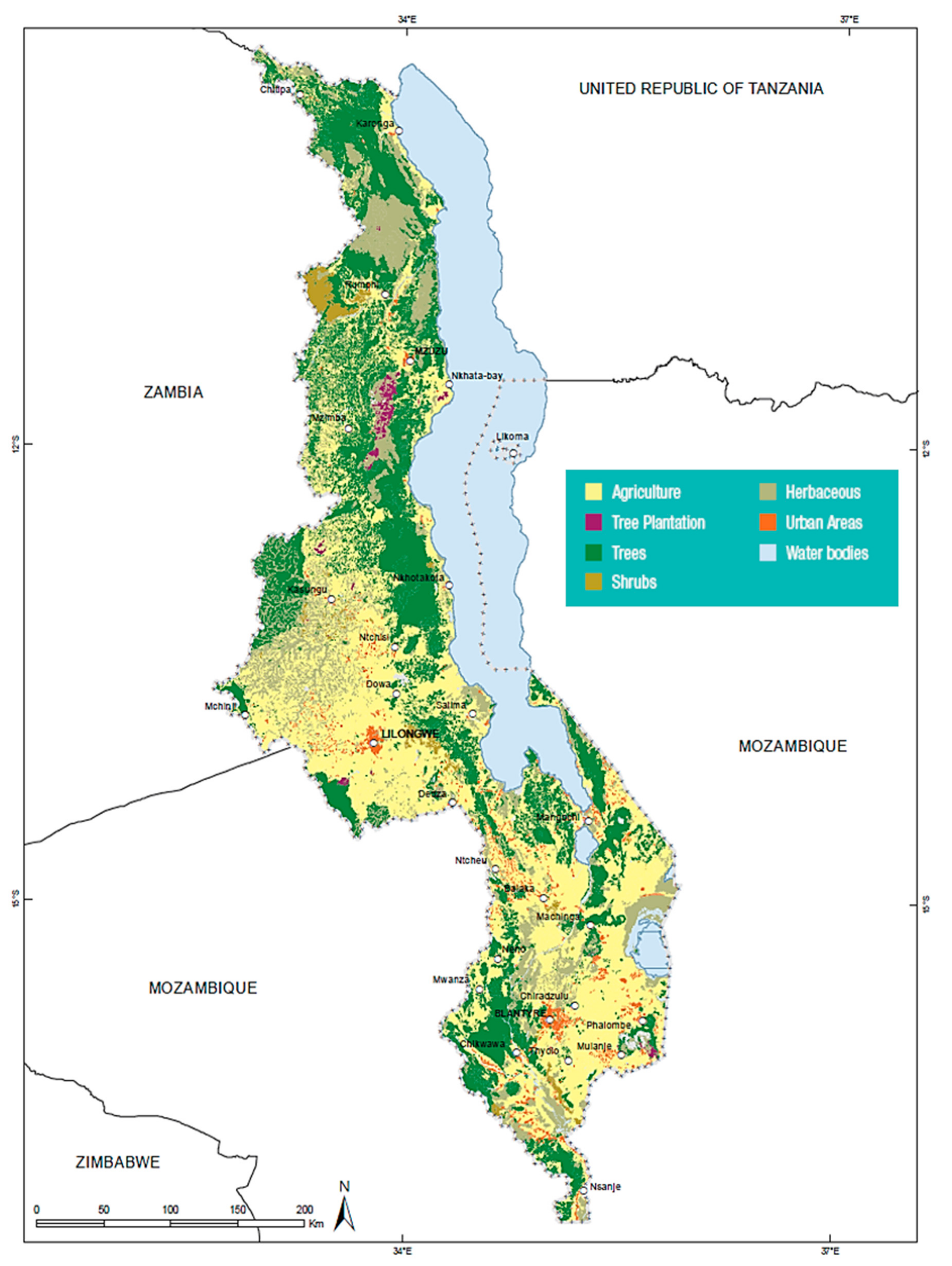
1.1. Rates of Deforestation in Malawi
1.2. Drivers of Deforestation
1.3. Response to Deforestation
1.4. The Misuku Hills Study
2. Materials and Methods
2.1. Malawi Forestry Policy Evolution and Analysis
2.2. Conservation Activity Inventory in the Misuku Hills Forested Region
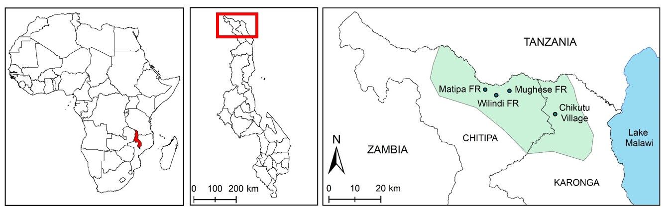
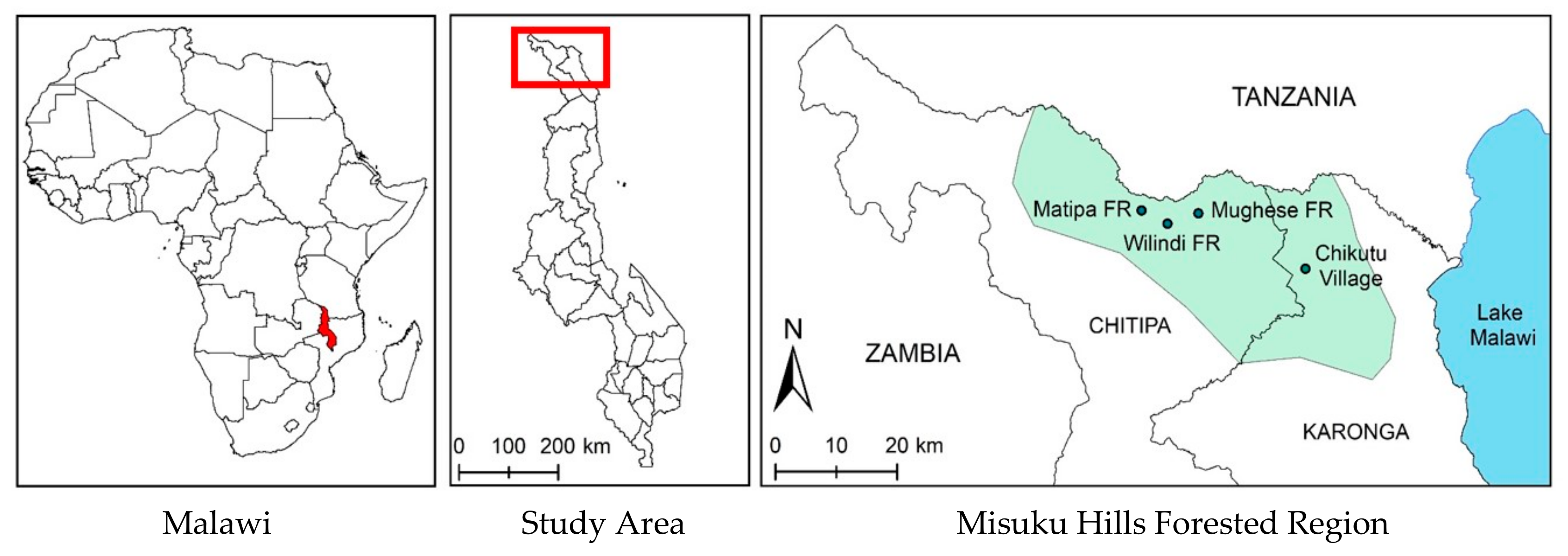
2.2.1. The Misuku Hills Forested Region Study Area
2.2.2. Conservation Activities Inventory
2.3. Chikutu Village Ecosystem Services Inventory
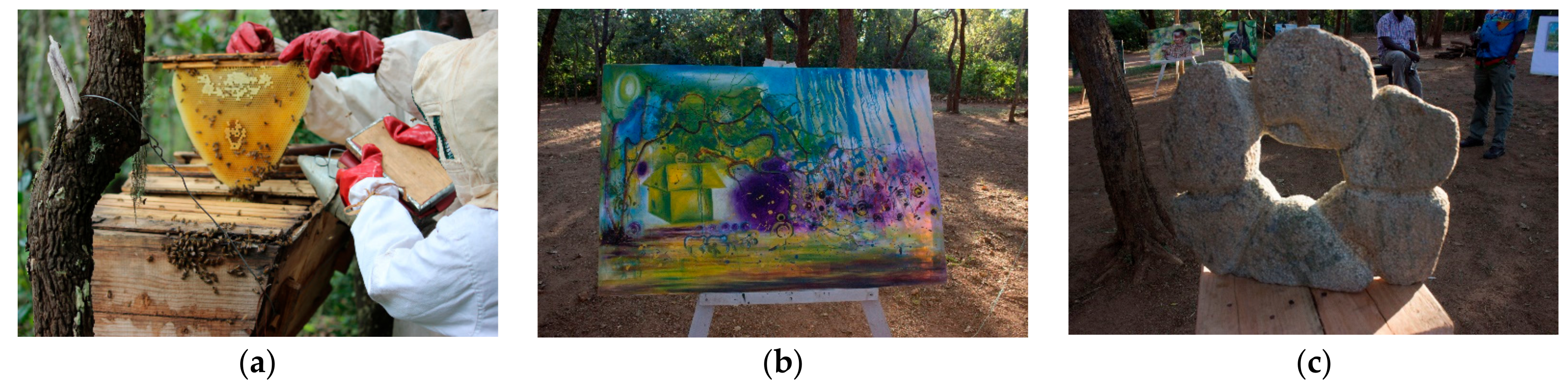
2.3.1. Ecosystem Services Assessment Photovoice Exercise
3. Results
3.1. Malawi Forestry Policy
- 1942 Forest Act: Pre-independence command and control forest management
- 1994 National Environmental Action Plan
- 1996 National Forest Policy: First post-independence forest policy aimed at supporting the 1996 National Environmental Policy and the Environment Management Act
- 1997 Forestry Act: Enabling and enforcement legislation to support 1996 forest policy
- 2001 National Forestry Program: Strategic framework for linking policy and practice or to translate good intentions into real results
- 2001 Forestry Rules
- 2001 Forestry (Community Participation) Rules
- 2003 National Forest Policy
- 2003 Forestry Amendment Rules
- 2003 Community Based Forest Management: Supplement to the 2003 National Forestry Policy expanding on “aspects related to community based forest management, including access to resources, benefit sharing, the role of traditional leaders, and decentralization” [57] (p. 10)
- 2004 National Environmental Policy: Includes principles and strategies for sustainably managing forests
- 2013 Standards & Guidelines for Participatory Forestry in Malawi: Developed to guide the practice of participatory forestry management and establish standards for forestry extension service delivery and improved forest management
- 2016 National Forest Policy: Coordinates all natural resource management, including forest resources and environmental policy instruments in Malawi
- 2017 National Forest Landscape Restoration Strategy
- 2017 Environment Management Act
- 2018 A Framework for Monitoring Progress on Malawi’s National Forest Landscape Restoration
3.1.1. Village Natural Resource Management Committees and Village Forest Areas
3.2. Conservation Activity Inventory in the Misuku Hills Region
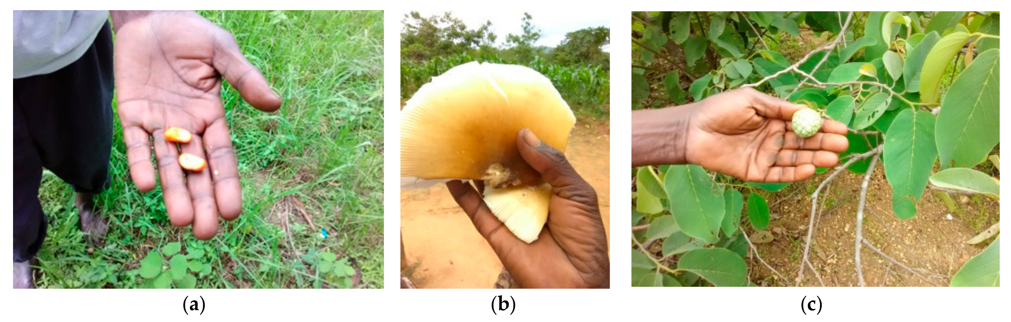
3.3. Chikutu Village Ecosystem Services Inventory
4. Discussion
4.1. Good Governance
4.2. Local Control
4.3. Forest-Based Enterprises
Non-Cash Value
4.4. Future Research
5. Conclusions
Author Contributions
Funding
Acknowledgments
Conflicts of Interest
Appendix A
Forest Cover Data Discrepancies and Implications
References
- Bare, M.; Kauffman, C.; Miller, D.C. Assessing the impact of international conservation aid on deforestation in sub-Saharan Africa. Environ. Res. Lett. 2015, 10, 125010. [Google Scholar] [CrossRef]
- Ordway, E.M.; Asner, G.P.; Lambin, E.F. Deforestation risk due to commodity crop expansion in sub-Saharan Africa. Environ. Res. Lett. 2017, 12, 044015. [Google Scholar] [CrossRef]
- Dimobe, K.; Ouédraogo, A.; Soma, S.; Goetze, D.; Porembski, S.; Thiombiano, A. Identification of driving factors of land degradation and deforestation in the Wildlife Reserve of Bontioli (Burkina Faso, West Africa). Glob. Ecol. Conserv. 2015, 4, 559–571. [Google Scholar] [CrossRef]
- Rudel, T.K. The national determinants of deforestation in sub-Saharan Africa. Philos. Trans. R. Soc. B Biol. Sci. 2013, 368. [Google Scholar] [CrossRef] [PubMed]
- Food and Agriculture Organization of the United Nations. Atlas of Malawi Land Cover and Land Cover Change; Food and Agriculture Organization of the United Nations: Rome, Italy, 2013. [Google Scholar]
- Mauambeta, D.; Chitedze, D.; Mumba, R. Status of Forests and Tree Management in MALAWI; Coordination Union for Rehabilitation of the Environment: Blantyre, Malawi, 2010. [Google Scholar]
- Food and Agriculture Organization of the United Nations. An Integrated Approach to Improve the Management of Forests and Other Natural Resources: The Case of Malawi; Food and Agriculture Organization of the United Nations: Rome, Italy, 2009. [Google Scholar]
- Gowela, J.P.; Masamba, C.R. State of Forest and Tree Genetic Resources in Malawi; Food and Agriculture Organization of the United Nations: Rome, Italy, 2002. [Google Scholar]
- Ministry of Lands and Housing. Malawi National Land Policy; Government of the Republic of Malawi: Lilongwe, Malawi, 2002.
- The Program on Governance and Local Development. The Local Governance Performance Index (LGPI) in Malawi: Selected Findings on Land; The Program on Governance and Local Development: Gothenburg, Sweden, 2016. [Google Scholar]
- Minde, I.J.; Kowero, G.; Ngugi, D.; Luhanga, J. Agricultural land expansion and deforestation in Malawi. For. Trees Livelihoods 2001, 11, 167–182. [Google Scholar] [CrossRef]
- National Statistical Office. 2018 Malawi Population and Housing Census; Government of the Republic of Malawi: Lilongwe, Malawi, 2018.
- Forestry Research Institute of Malawi. State of the World’s Forest Genetic Resources. Country Report: Malawi; Food and Agriculture Organization of the United Nations: Rome, Italy, 2013. [Google Scholar]
- Bone, R.A.; Parks, K.E.; Hudson, M.D.; Tsirinzeni, M.; Willcock, S. Deforestation since independence: A quantitative assessment of four decades of land-cover change in Malawi. South. For. 2017, 79, 269–275. [Google Scholar] [CrossRef]
- Munthali, M.G.; Davis, N.; Adeola, A.M.; Botai, J.O.; Kamwi, J.M.; Chisale, H.L.W.; Orimoogunje, O.O.I. Local perception of drivers of Land-Use and Land-Cover change dynamics across Dedza district, Central Malawi region. Sustainability 2019, 11, 832. [Google Scholar] [CrossRef]
- Department of Forestry. Malawi’s National Forestry Programme: Priorities for Improving Forestry and Livelihoods; Government of the Republic of Malawi: Lilongwe, Malawi, 2001.
- World Bank GNI per Capita, Atlas Method (Current US$). Available online: https://data.worldbank.org/indicator/NY.GNP.PCAP.CD?locations=MW&view=chart&year_high_desc=false (accessed on 28 March 2019).
- Meijer, S.S.; Catacutan, D.; Sileshi, G.W.; Nieuwenhuis, M. Tree planting by smallholder farmers in Malawi: Using the theory of planned behaviour to examine the relationship between attitudes and behaviour. J. Environ. Psychol. 2015, 43, 1–12. [Google Scholar] [CrossRef]
- Meijer, S.S.; Sileshi, G.W.; Catacutan, D.; Nieuwenhuis, M. Agroforestry and deforestation in Malawi: Inter-linkages between attitudes, beliefs and behaviours. Agrofor. Syst. 2016, 90, 645–658. [Google Scholar] [CrossRef]
- Meijer, S.S.; Sileshi, G.W.; Catacutan, D.; Nieuwenhuis, M. Farmers and forest conservation in Malawi: The disconnect between attitudes, intentions and behaviour. For. Trees Livelihoods 2016, 25, 59–77. [Google Scholar] [CrossRef]
- Chavula, J. Smoke over Dzalanyama forest. The Nation, 20 April 2019; 8–9. [Google Scholar]
- Kwesiga, F.; Mwanza, S. Underexploited wild genetic resources: The case of indigenous fruittrees in Eastern Zambia. In Improvement of Indigenous Fruit Trees of the Miombo Woodlands of southern Africa; Maghembe, J.A., Ntupanyama, Y., Chirwa, P.W., Eds.; PrimexPrinters, ICRAF: Nairobi, Kenya, 1995; pp. 100–112. [Google Scholar]
- Maghembe, J.A.; Ntupanyama, Y.; Chirwa, P.W. Improvement of Indigenous Fruit Trees of the Miombo Woodlands of Southern Africa; PrimexPrinters, ICRAF: Nairobi, Kenya, 1995. [Google Scholar]
- Campbell, B.M. The use of wild fruits in Zimbabwe. Econ. Bot. 1987, 41, 375–385. [Google Scholar] [CrossRef]
- Lowore, J. Miombo Woodlands and Rural Livelihoods in Malawi; Center for International Forestry Research: Bogor, Indonesia, 2006. [Google Scholar]
- Hecht, J.; Kasulo, V. Development of Forest Valuation Systems Malawi; Cardno Emerging Markets: London, UK, 2013. [Google Scholar]
- Ministry of Natural Resources Energy and Mining. National Forest Policy; Government of the Republic of Malawi: Lilongwe, Malawi, 2016.
- Yaron, G.; Mangani, R.; Mlava, J.; Kambewa, P.; Makungwa, S.; Mtethiwa, A.; Munthali, S.; Mgoola, W.; Kazembe, J. Economic Valuation of Sustainable Natural Resource Use in Malawi; Government of the Republic of Malawi: Lilongwe, Malawi, 2010.
- Ministry of Natural Resources Energy and Environment. Malawi State of Environment and Outlook Report; Government of the Republic of Malawi: Lilongwe, Malawi, 2010.
- Ngwira, S.; Watanabe, T. An Analysis of the Causes of Deforestation in Malawi: A Case of Mwazisi. Land 2019, 8, 48. [Google Scholar] [CrossRef]
- Twongyirwe, R.; Bithell, M.; Richards, K.S. Revisiting the drivers of deforestation in the tropics: Insights from local and key informant perceptions in western Uganda. J. Rural Stud. 2018, 63, 105–119. [Google Scholar] [CrossRef]
- KBA Partnership World Database of Key Biological Areas. Available online: http://www.keybiodiversityareas.org/site/factsheet/misuku-hills-forest-reserves-iba-malawi (accessed on 11 April 2019).
- Wangai, P.W.; Burkhard, B.; Müller, F. A review of studies on ecosystem services in Africa. Int. J. Sustain. Built Environ. 2016, 5, 225–245. [Google Scholar] [CrossRef]
- Droissart, V.; Dauby, G.; Hardy, O.J.; Deblauwe, V.; Harris, D.J.; Janssens, S.; Mackinder, B.A.; Blach-Overgaard, A.; Sonké, B.; Sosef, M.S.M.; et al. Beyond trees: Biogeographical regionalization of tropical Africa. J. Biogeogr. 2018, 45, 1153–1167. [Google Scholar] [CrossRef]
- BirdLife International Misuku Hills Forest Reserves. Available online: http://datazone.birdlife.org/site/factsheet/misuku-hills-forest-reserves-iba-malawi (accessed on 2 April 2019).
- Government of Malawi. Malawi Vegetation/Biotic Communites; Government of the Republic of Malawi: Lilongwe, Malawi, 1979.
- Potts, D. Rural mobility as a response to land shortages: The case of Malawi. Popul. Space Place 2006, 12, 291–311. [Google Scholar] [CrossRef]
- National Statistical Office. Integrated Household Survey, 2016–2017; Government of the Republic of Malawi: Lilongwe, Malawi, 2017.
- Ministry of Natural Resources Energy and Mining. National Landscape Restoration Strategy; Government of the Republic of Malawi: Lilongwe, Malawi, 2017.
- USAID. Community Based Natural Resource Management: Stocktaking Assessment; United States Agency for International Development: Washington, DC, USA, 2010.
- Wang, C.; Burris, M.A. Empowerment through Photo Novella: Portraits of Participation. Health Educ. Behav. 1994, 21, 171–186. [Google Scholar] [CrossRef]
- Wang, C.; Burris, M.A. Photovoice: Concept, methodology, and use for participatory needs assessment. Health Educ. Behav. 1997, 24, 369–387. [Google Scholar] [CrossRef]
- Wang, C.C.; Yi, W.K.; Tao, Z.W.; Carovano, K. Photovoice as a participatory health promotion strategy. Health Promot. Int. 1998, 13, 75–86. [Google Scholar] [CrossRef]
- Barndt, D. Making, naming, and connecting—Reclaiming lost arts: The pedagogical possibilities of photostory production. In Participatory Practices in Adult Education; Campbell, P., Burnaby, B., Eds.; Lawrence Erlbaum: Mahwah, NJ, USA, 2001; pp. 31–54. [Google Scholar]
- Gallo, M. Immigrant workers’ journeys through a new culture: Exploring the transformative learning possibilities of photography. Stud. Educ. Adults 2001, 33, 109–117. [Google Scholar] [CrossRef]
- Luttrell, W. Making culture visible: Children’s photography, identity and agency. In Proceedings of the Annual Meeting of the American Sociological Association, Montreal, QC, Canada, 11–14 August 2006. [Google Scholar]
- McAllister, C.; Wilson, P.; Green, B.; Baldwin, J. Come and take a walk: Listening to Early Head Start parents on school-readiness as a matter of child, family, and community health. Am. J. Public Health 2005, 95, 617–625. [Google Scholar] [CrossRef] [PubMed]
- Prins, E. Participatory photography: A tool for empowerment or surveillance? Action Res. 2010, 8, 426–443. [Google Scholar] [CrossRef]
- Harris, J.C. Vulnerable Youth’s Perspectives and Priorities for Informal Settlements: Photovoice Evidence from Lusaka, Zambia. J. Plan. Educ. Res. 2018, 38, 398–412. [Google Scholar] [CrossRef]
- Wang, C.C. Photovoice: A participatory action research strategy applied to women’s health. J. Women’s Health 1999, 8, 185–192. [Google Scholar] [CrossRef] [PubMed]
- Lykes, M. Creative arts and photography action research in Guatemala. In Handbook of Action Research; Reason, P., Bradbury, H., Eds.; SAGE Publications, Inc.: Thousand Oaks, CA, USA, 2001; pp. 363–371. [Google Scholar]
- McIntyre, A. Through the eyes of women: Photovoice and participatory research as tools for reimagining place. Gender Place Cult. 2003, 10, 47–66. [Google Scholar] [CrossRef]
- Chonady, J.; Ferman, B.; Amitrani-Welsh, J.; Martin, T. Violence through the eyes of youth: A Photovoice exploration. J. Community Psychol. 2013, 41, 84–101. [Google Scholar] [CrossRef]
- Berbés-Blázquez, M. A participatory assessment of ecosystem services and human wellbeing in rural costa rica using photo-voice. Environ. Manag. 2011, 49, 862–875. [Google Scholar] [CrossRef]
- Pereira, E.; Queiroz, C.; Pereira, H.M.; Vicente, L. Ecosystem services and human well-being: A participatory study in a mountain community in Portugal. Ecol. Soc. 2005, 10, 14. [Google Scholar] [CrossRef]
- Action for Environmental Sustainability. Misuku Hills Improved Livelihood and Biodiversity Conservation Project Biodiversity Survey Report; Action for Environmental Sustainability: Blantyre, Malawi, 2015. [Google Scholar]
- McConnell, R.; Sibale, B.; Utila, H. Linking Forest Programmes and Poverty Reduction Strategies, Malawi; Food and Agriculture Organization of the United Nations: Rome, Italy, 2007. [Google Scholar]
- Ministry of Natural Resources. National Forest Policy; Government of the Republic of Malawi: Lilongwe, Malawi, 1996.
- Kamoto, J.F.; Dorward, P.T.; Shepherd, D.D. Decentralised Governance of Forest Resources: Analysing Devotion Policy Processes and Their Effects on Decision Making in Communal Forest Management in Malawi; International Association for the Study of the Commons: Utrecht, The Netherlands, 2008. [Google Scholar]
- Ministry of Local Government and Rural Development. Revised Decentralized Environmental Management Guidelines; Government of the Republic of Malawi: Lilongwe, Malawi, 2012.
- Millington, S.; Kaferawanthu, M. Analysis of Biodiversity Threats & Opportunities in Malawi; United States Agency for International Development: Washington, DC, USA, 2005.
- World Bank. Malawi Country Environmental Analysis; The World Bank: Washington, DC, USA, 2019. [Google Scholar]
- Ministry of Mines Natural Resources and Environment. Standards & Guidelines for Participatory Forestry in Malawi; Government of the Republic of Malawi: Lilongwe, Malawi, 2013.
- Reytar, K.; Ray, S.; Toh, L. Malawi is Putting its Money Where Its Forests Are. Available online: https://www.wri.org/blog/2018/12/malawi-putting-its-money-where-its-forests-are (accessed on 30 March 2019).
- Mwale, J. Youth scheme in shambles. The Nation, 21 April 2019; 4–5. [Google Scholar]
- USAID COMPASS ll: Community Partnerships for Sustainable Resources Management in Malawi. Available online: https://rmportal.net/library/content/tools/compass-ii (accessed on 3 April 2019).
- USAID. Final Project Report; United States Agency for International Development: Washington, DC, USA, 2009.
- LTS International Improved Forest Management for Sustainable Livelihoods Programme. Available online: https://www.ltsi.co.uk/project/malawi-improved-forest-management-for-sustainable-livelihoods-programme (accessed on 5 April 2019).
- GOPA Worldwide Consultants. GOPA Project Database. Available online: https://www.gopa.de/en/projects/improved-forest-management-sustainable-livelihoods-programme-ifmslp-phase-ii (accessed on 6 April 2019).
- Zulu, L. Bringing people back into protected forests in developing countries: Insights from co-management in Malawi. Sustainability 2013, 5, 1917–1943. [Google Scholar] [CrossRef]
- TRANSTEC SA. Final Evaluation of Improved Forest Management for Sustainable Livelihoods Programme; TRANSTEC: Brussels, Belgium, 2012. [Google Scholar]
- Action for Environmental Sustainability. Matipa Forest Management Plan; Action for Environmental Sustainability: Blantyre, Malawi, 2010. [Google Scholar]
- Mazanga, G. Misuku Hills Indigenous Forest Project Final Project Completion Report; Sustainable Development Initiative: Blantyre, Malawi, 2016. [Google Scholar]
- Misuku Hills Beekeepers Association. Misuku Beekeeping Value Addition Project Completion Report; Misuku Hills Beekeepers Association: Chitipa, Malawi, 2016. [Google Scholar]
- UNDP Promotion of Indigenous Forests in the Misuku Hills Area. Available online: https://sgp.undp.org/spacial-itemid-projects-landing-page/spacial-itemid-project-search-results/spacial-itemid-project-detailpage.html?view=projectdetail&id=20503 (accessed on 11 April 2019).
- Kumbani, P. Misuku Hills, hidden treasure. The Nation, 28 March 2017. [Google Scholar]
- Sustainable Development Initiative. CEPF Small Grant Final Project Completion Report; Sustainable Development Initiative: Blantyre, Malawi, 2017. [Google Scholar]
- Byers, B. Conserving the Miombo Ecoregion; WWF Southern Africa Regional Programme Office (SARPO): Harare, Zimbabwe, 2001; p. 32. [Google Scholar]
- Campbell, B.M.; Angelsen, A.; Cunningham, A.B.; Katerere, Y.; Sitoe, A.A.; Wunder, S. Miombo Woodlands—Opportunities and Barriers to Sustainable Forest Management; CIFOR: Bogor, Indonesia, 2007; p. 41. [Google Scholar]
- The Economist Intelligence Unit. Democracy Index 2018: Me too? The Economist Intelligence Unit: London, UK, 2019. [Google Scholar]
- Miller, T.; Kim, A.B.; Roberts, J.M. 2019 Index of Economic Freedom; The Heritage Foundation: Washington, DC, USA, 2019. [Google Scholar]
- Remme, H.; Muyambi, F.; Kamoto, J.; Dengu, E. A Technical Review of Community Based Forest Management on both Customary Land and Forest Reserves (Participatory Forest Management); TRANSTEC: Brussels, Belgium, 2015. [Google Scholar]
- M’bwana, L. Malawi Government Will Continue Using Army Soldiers to Protect Forest Reserves from Further Depletion. Available online: http://www.maravipost.com/malawi-government-will-continue-using-army-soldiers-protect-forest-reserves-depletion/ (accessed on 14 April 2019).
- Mkwapatira, M. Malawians plant over 50 million trees. The Nation, 22 April 2019; 3. [Google Scholar]
- Chinangwa, L.; Sinclair, F.; Pullin, A.S.; Hockley, N. Can co-management of government forest reserves achieve devolution? Evidence from Malawi. For. Trees Livelihoods 2016, 25, 41–58. [Google Scholar] [CrossRef]
- Zulu, L.C. Community Forest Management in Southern Malawi: Solution or Part of the Problem? Soc. Nat. Resour. 2008, 21, 687–703. [Google Scholar]
- Chinangwa, L.L.; Pullin, A.S.; Hockley, N. Impact of forest co-management programs on forest conditions in Malawi. J. Sustain. For. 2017, 36, 338–357. [Google Scholar] [CrossRef]
- Mtambo, C.; Missanjo, E. The Impact of Participatory Forest Management on Tree Species Abundance and Diversity in Selected Village Forest Areas in Kasungu, Malawi. J. Ecol. Environ. Sci. 2015, 3, 15–20. [Google Scholar]
- Sunderlin, W.D.; Angelsen, A.; Belcher, B.; Burgers, P.; Nasi, R.; Santoso, L.; Wunder, S. Livelihoods, forests, and conservation in developing countries: An Overview. World Dev. 2005, 33, 1383–1402. [Google Scholar] [CrossRef]
- Salafsky, N.; Wollenberg, E. Linking livelihoods and conservation: A conceptual framework and scale for assessing the integration of human needs and biodiversity. World Dev. 2000, 28, 1421–1438. [Google Scholar] [CrossRef]
- Mather, A.; Needle, C. The Forest Transition: A Theoretical Basis. Area 1992, 2, 117–124. [Google Scholar] [CrossRef]
- Rudel, T.K.; Coomes, O.T.; Moran, E.; Achard, F.; Angelsen, A.; Xu, J.; Lambin, E. Forest transitions: Towards a global understanding of land use change. Glob. Environ. Chang. 2005, 15, 23–31. [Google Scholar] [CrossRef]
- Rudel, T.K. Is there a forest transition? Deforestation, reforestation, and development. Rural Sociol. 1998, 63, 533–552. [Google Scholar] [CrossRef]
- Nyirongo, K. Human Activity Endanger Bird Species in Misuku. Available online: http://www.manaonline.gov.mw/index.php/national/environment/item/6955-human-activity-endanger-bird-species-in-misuku (accessed on 22 April 2019).
- Plummer, R.; Fennell, D. Exploring co-management theory: Prospects for sociobiology and reciprocal altruism. J. Environ. Manag. 2007, 85, 944–955. [Google Scholar] [CrossRef]
- Trivers, R.L. The evolution of reciprocal altruism. Q. Rev. Biol. 1971, 46, 35–57. [Google Scholar] [CrossRef]
- Bunderson, W.T.; Hayes, I.M. Agricultural and environmental sustainability in Malawi. In Proceedings of the Conference on Sustainable Agriculture for Africa, Abidjan, Cote d’Ivoire, 17–21 July 1995. [Google Scholar]
- Center for Environmental Policy and Advocacy. National Forest Policy in Malawi; Center for Environmental Policy and Advocacy: Blantyre, Malawi, 2010. [Google Scholar]
- Haack, B.; Mahabir, R.; Kerkering, J. Remote sensing-derived national land cover land use maps: A comparison for Malawi. Geocarto Int. 2015, 30, 270–292. [Google Scholar] [CrossRef]
- The Ministry of Natural Resources Energy and Mining. A Framework for Monitoring Progress on Malawi’s National Forest Landscape Restoration; Government of the Republic of Malawi: Lilongwe, Malawi, 2018.


| District | Proportion of Enterprises Selling Forest Products | Own Land | Forest/Wild Park Reserve | Communal Land | Purchased from Someone |
|---|---|---|---|---|---|
| Chitipa | 11.5 | 12.2 | 37.8 | 8.9 | 41.2 |
| Karonga | 12.3 | 15.0 | 27.7 | 41.6 | 15.7 |
| Date | Project | Implementing Organizations | Funders |
|---|---|---|---|
| 1999–2004 | COMPASS I | Development Alternatives Inc. | USAID 1 |
| 2006–2009 | COMPASS II | Development Alternatives Inc. | USAID 1 |
| 2006–2010 | IFMSLP I | LTS 2 | European Commission |
| 2011–2014 | IFMSLP II | GOPA 3 | European Commission |
| Improved Livelihood and Biodiversity Conservation Project | Subcontract to CEPF 4, AfES 5 | ||
| Misuku Hills Indigenous Forest Project | Subcontract to CEPF 4, MBA 6, SDI 7 | ||
| 2013 | Misuku Beekeeping Value Addition Project | MBA 6, SDI 7 | British High Commission |
| 2013–2015 | Promotion of Indigenous Forests in the Misuku Hills Area | MBA 6 | UNDP GEF 8 |
| 2017 | Misuku Hills Art Challenge | AfES 5, MBA 6, SDI 7 | CEPF 4 |
| 2018 | Small Producers Development Project | MBA 6, SDI 7 | IM-Swedish Development Partners |
| Local Name | Type of Forest Product | Local Uses | Notes |
|---|---|---|---|
| Ndilolo | Tree 1 | Food | Nut casing consumed and used for juice |
| Manga | Tree | Food | Mango fruit |
| Munyere | Shrub | Food | Wild avocado |
| Miyombo | Shrub | Construction | Stems used for rope |
| Mulungalunga | Tree | Medicine | Roots |
| Masuku | Herbaceous plant | Food | Fruit |
| Mushombe | Bamboo | Construction | |
| Mufiomi | Tree | Timber | Recognized for water conservation properties |
| Mwina | Tree | Timber | Noted as being very dense |
| Malina | Grass | Timber | Also animal feed |
| Dongo | Soil | Food | |
| Ntochi | Herbaceous plant | Food | Banana |
| Chighughu | Grass | Erosion control | Also animal feed |
| Popo | Tree | Food | Papaya |
| Chiwowa | Fungus | Food | Mushroom |
| Guaves | Tree | Food | Guava |
© 2019 by the authors. Licensee MDPI, Basel, Switzerland. This article is an open access article distributed under the terms and conditions of the Creative Commons Attribution (CC BY) license (http://creativecommons.org/licenses/by/4.0/).
Share and Cite
Coutts, C.; Holmes, T.; Jackson, A. Forestry Policy, Conservation Activities, and Ecosystem Services in the Remote Misuku Hills of Malawi. Forests 2019, 10, 1056. https://doi.org/10.3390/f10121056
Coutts C, Holmes T, Jackson A. Forestry Policy, Conservation Activities, and Ecosystem Services in the Remote Misuku Hills of Malawi. Forests. 2019; 10(12):1056. https://doi.org/10.3390/f10121056
Chicago/Turabian StyleCoutts, Christopher, Tisha Holmes, and April Jackson. 2019. "Forestry Policy, Conservation Activities, and Ecosystem Services in the Remote Misuku Hills of Malawi" Forests 10, no. 12: 1056. https://doi.org/10.3390/f10121056