
The Utilization of the WMO-1234 Guidance to Improve Citizen’s Wellness and Health: An Italian Perspective


Abstract
:1. Introduction
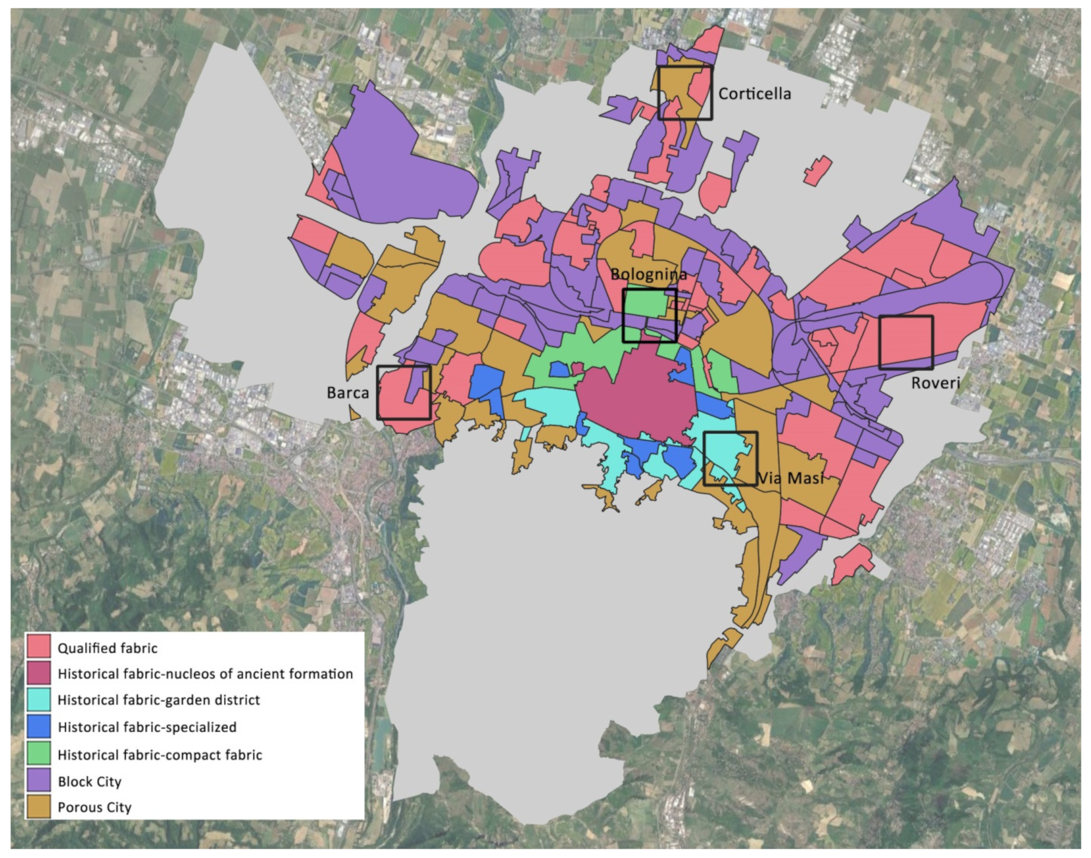
2. Methodology
- The identification of the vulnerabilities of places and areas of aggregation for weaker groups of municipal property and properties of public interest.
- The detection of natural/environmental elements or particular conditions (including risk) in the weaker groups’ aggregation areas and, more generally, in the area.
- The selection of actions that mitigate the physiological climatic problem in the identified vulnerable points.
- Verification of the microclimate modeling of the selected project scenarios using microclimate modeling tools (ex-post simulations with ENVI-met [30]) regarding the specific objectives of each strategy.
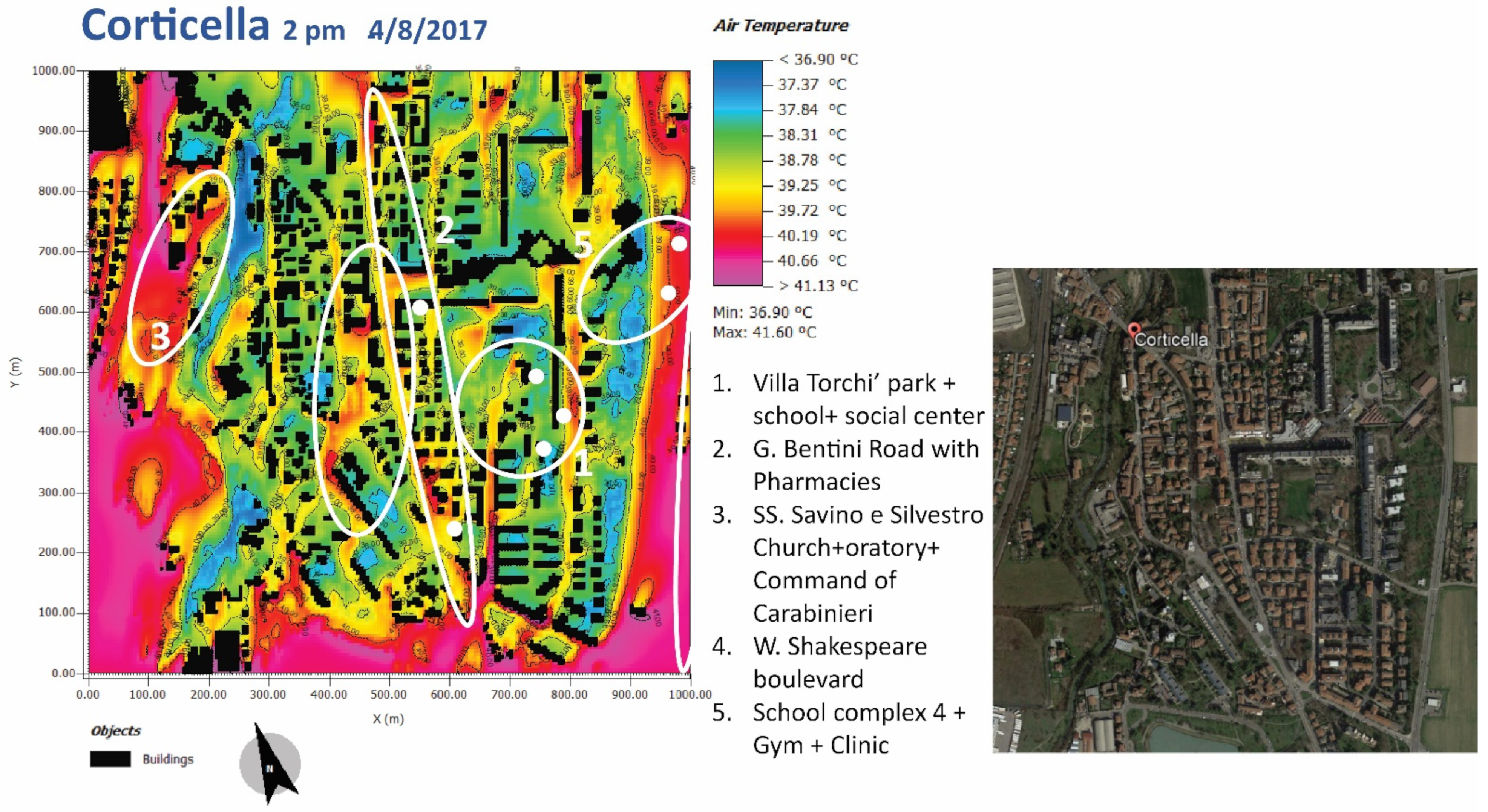
3. Results and Discussion
4. Conclusions
Author Contributions
Funding
Institutional Review Board Statement
Informed Consent Statement
Acknowledgments
Conflicts of Interest
References
- UN. Do You Know All 17 SDGs. Department of Economic and Social Affairs Sustainable Development. 2022. Available online: https://sdgs.un.org/goals (accessed on 29 September 2022).
- Mason, H.; King, J.C.; Peden, A.E.; Franklin, R.C. Systematic review of the impact of heatwaves on health service demand in Australia. BMC Health Serv. Res. 2022, 22, 960. [Google Scholar] [CrossRef] [PubMed]
- Åström, D.O.; Schifano, P.; Asta, F.; Lallo, A.; Michelozzi, P.; Rocklöv, J.; Forsberg, B. The effect of heat waves on mortality in susceptible groups: A cohort study of a mediterranean and a northern European City. Environ. Health 2015, 14, 30. [Google Scholar] [CrossRef] [PubMed] [Green Version]
- International Labour Office—Geneva. Working on a Warmer Planet: The Impact of Heat Stress on Labour Productivity and Decent Work; International Labour Office—Geneva, ILO: Geneva, Switzerland, 2019. [Google Scholar]
- Shiva, J.S.; Chandler, D.G.; Kunkel, K.E. Mapping HeatWave Hazard in Urban Areas: A Novel Multi-Criteria Decision Making Approach. Atmosphere 2022, 13, 1037. [Google Scholar] [CrossRef]
- Smith, K.R.; Woodward, A.; Campbell-Lendrum, D.; Chadee, D.D.; Honda, Y.; Liu, Q.; Olwoch, J.M.; Revich, B.; Sauerborn, R. 2014: Human health: Impacts, adaptation, and co-benefits. In Climate Change 2014: Impacts, Adaptation, and Vulnerability. Part A: Global and Sectoral Aspects. Contribution of Working Group II to the Fifth Assessment Report of the Intergovernmental Panel on Climate Change; Field, C.B., Barros, V.R., Dokken, D.J., Mach, K.J., Mastrandrea, M.D., Bilir, T.E., Chatterjee, M., Ebi, K.L., Estrada, Y.O., Genova, R.C., et al., Eds.; Cambridge University Press: Cambridge, UK; New York, NY, USA, 2014; pp. 709–754. [Google Scholar]
- Kaltsatou, A.; Kenny, G.P.; Flouris, A.D. The Impact of Heat Waves on Mortality among the Elderly: A Mini Systematic Review. J. Geriatr. Med. Gerontol. 2018, 4, 53. [Google Scholar] [CrossRef]
- Xu, Z.; Sheffield, P.E.; Su, H.; Wang, X.; Bi, Y.; Tong, S. The impact of heat waves on children’s health: A systematic review. Int. J. Biometeorol. 2014, 58, 239–247. [Google Scholar] [CrossRef]
- Seltenrich, N. Just What the Doctor Ordered—Using Parks to Improve Children’s Health. Environ. Health Perspect. 2015, 123, 10. [Google Scholar] [CrossRef] [Green Version]
- Moon, J. The effect of the heatwave on the morbidity and mortality of diabetes patients; a meta-analysis for the era of the climate crisis. Environ. Res. 2021, 195, 110762. [Google Scholar] [CrossRef]
- Hajat, S.; Haines, A.; Sarran, C.; Sharma, A.; Bates, C.; Fleming, L.E. The effect of ambient temperature on type- 2-diabetes: Case-crossover analysis of 4+ million GP consultations across England. Environ. Health 2017, 16, 73. [Google Scholar] [CrossRef] [Green Version]
- Liu, J.; Varghese, B.M.; Hansen, A.; Xiang, J.; Zhang, Y.; Dear, K.; Gourley, M.; Driscoll, T.; Morgan, G.; Capon, A.; et al. Is there an association between hot weather and poor mental health outcomes? A systematic review and meta-analysis. Environ. Int. 2021, 153, 106533. [Google Scholar] [CrossRef]
- Sousa, P.M.; Trigo, R.M.; Russo, A.; Geirinhas, J.L.; Rodrigues, A.; Silva, S.; Torres, A. Heat-related mortality amplified during the COVID-19 pandemic. Int. J. Biometeorol. 2022, 66, 457–468. [Google Scholar] [CrossRef]
- World Health Organization. Social Isolation and Loneliness among Older People: Advocacy Brief; Licence: CC BY-NC-SA 3.0 IGO; World Health Organization: Geneva, Switzerland, 2021; ISBN 978-92-4-003074-9. (electronic version); Available online: https://www.who.int/publications/i/item/9789240030749 (accessed on 21 October 2022).
- Bose-O’Reilly, S.; Daanen, H.; Deering, K.; Gerrett, N.; Huynen, M.M.T.E.; Lee, J.; Karrasch, S.; Matthies-Wieslerl, F.; Mertes, H.; Schoierer, J.; et al. COVID-19 and heat waves: New challenges for healthcare systems. Environ. Res. 2021, 198, 111153. [Google Scholar] [CrossRef]
- Maggiotto, G.; Miani, A.; Rizzo, E.; Castellone, M.D.; Piscitelli, P. Heat waves and adaptation strategies in a mediterranean urban context. Environ. Res. 2021, 197, 111066. [Google Scholar] [CrossRef]
- Morabito, M.; Crisci, A.; Gioli, B.; Gualtieri, G.; Toscano, P.; Di Stefano, V.; Orlandini, S.; Gensini, G.F. Urban-Hazard Risk Analysis: Mapping of Heat-Related Risks in the Elderly in Major Italian Cities. PLoS ONE 2015, 10, e0127277. [Google Scholar] [CrossRef] [Green Version]
- Ferrini, F.; Gori, A. Cities after COVID-19: How trees and green infrastructures can help shaping a sustainable future. Ri-Vista 2020, 19, 182–191. [Google Scholar] [CrossRef]
- WHO. Health in the Green Economy: Health Co-Benefits of Climate Change Mitigation—Housing Sector; World Health Organization: Geneva, Switzerland, 2011; Available online: https://www.who.int/publications/i/item/9789241501712 (accessed on 29 September 2022).
- Grimmond, S.; Bouchet, V.; Molina, L.T.; Baklanov, A.; Tan, J.; Schlünzen, K.H.; Mills, G.; Golding, B.; Masson, V.; Ren, C.; et al. Integrated urban hydrometeorological, climate and environmental services: Concept, methodology and key messages. Urban Clim. 2020, 33, 100623. [Google Scholar] [CrossRef]
- WMO. Guidance on Integrated Urban Hydrometeorological, Climate and Environmental Services—Volume I: Concept and Methodology. 2019. Available online: https://library.wmo.int/index.php?lvl=notice_display&id=21512#.YzlIzlJBw-Q (accessed on 27 September 2022).
- WMO. Guidance on Integrated Urban Hydrometeorological, Climate and Environment Services—Volume II: Demonstration Cities. 2021. Available online: https://library.wmo.int/index.php?lvl=notice_display&id=21855#.YzlRq1JBw-Q (accessed on 27 September 2022).
- Baklanov, A.; Cardenas, B.; Lee, T.-C.; Leroyer, S.; Massom, V.; Molina, L.T.; Müller, T.; Ren, C.; Vogel, F.R.; Voogt, J.A. Integrated urban services: Experience from four cities on different continents. Urban Clim. 2020, 32, 100610. [Google Scholar] [CrossRef]
- Russo, A.; Cirella, T. Urban Ecosystem Services: New Findings for Landscape Architects, Urban Planners, and Policymakers. Land 2021, 10, 88. [Google Scholar] [CrossRef]
- Ouyang, X.; Luo, X. Models for assessing Urban Ecosystem Services: Status and outlooks. Sustainability 2022, 14, 4725. Available online: https://www.mdpi.com/2071-1050/14/8/4725/htm (accessed on 27 September 2022). [CrossRef]
- Colavitti, A.M.; Floris, A.; Serra, S. Urban Standards and Ecosystem Services: The Evolution of the Services Planning in Italy from Theory to Practice. Sustainabilty 2020, 12, 2434. [Google Scholar] [CrossRef] [Green Version]
- Nardino, M.; Cremonini, L.; Georgiadis, T.; Mandanici, E.; Bitelli, G. Microclimate classification of Bologna (Italy) as a support tool for urban services and regeneration. J. Environ. Res. Public Health 2021, 18, 4898. [Google Scholar] [CrossRef]
- Nardino, M.; Cremonini, L.; Crisci, A.; Georgiadis, T.; Guerri, G.; Morabito, M.; Fiorillo, E. Mapping Thermal Patterns of Bologna Municipality (Italy) During a Heatwave: A New Methodology for Cities Adaptation to Global Climate Change. Urban Clim. 2022, 46, 101317. [Google Scholar] [CrossRef]
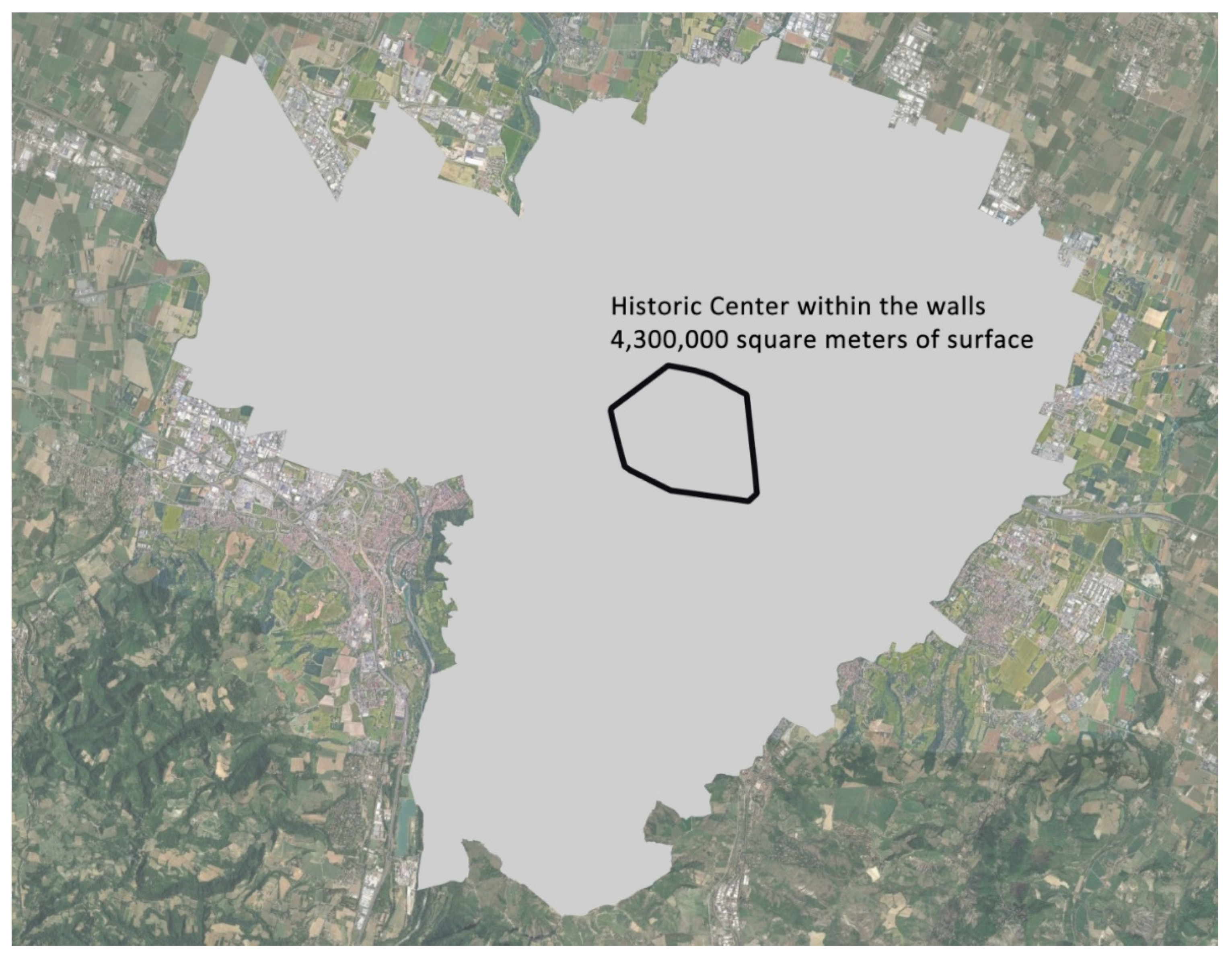
- Municipality of Bologna. Discipline of the General Urban Plan of the Municipality of Bologna. 2021. (In Italian). Available online: http://sit.comune.bologna.it/alfresco/d/d/workspace/SpacesStore/17a5f006-62e2-4364-8cec-bedc075ca833/DisciplinaDelPiano_APPRweb.pdf (accessed on 20 September 2022).
- Bruse, M.; Fleer, H. Simulating surface-plant-air interactions inside urban environments with a three dimensional numerical model. Environ. Model. Softw. 1998, 13, 373–384. [Google Scholar] [CrossRef]
- Wang, D.; Brown, G.; Liu, Y. The physical and non-physical factors that influence perceived access to urban parks. Landsc. Urban Plan. 2015, 133, 53–66. [Google Scholar] [CrossRef]
- Pearsall, H.; Eller, J.K. Locating the green space paradox: A study of gentrification and public green space accessibility in Philadelphia, Pennsylvania. Landsc. Urban Plan. 2020, 195, 103708. [Google Scholar] [CrossRef]
- Jarvisa, I.; Gergela, S.; Koehoornb, M.; den Boschab, M. Greenspace access does not correspond to nature exposure: Measures of urban natural space with implications for health research. Landsc. Urban Plan. 2020, 194, 103686. [Google Scholar] [CrossRef]
- Mullenbach, L.E.; Baker, B.L.; Mowen, A.J. Does public support of urban park development stem from gentrification beliefs and attitudes? Landsc. Urban Plan. 2021, 211, 104097. [Google Scholar] [CrossRef]
- Mahrousa, A.M.; Moustafab, Y.M.; El-Elac, M.A.A. Physical characteristics and perceived security in urban parks: Investigation in the Egyptian context. Ain Shams Eng. J. 2018, 9, 3055–3066. [Google Scholar] [CrossRef]
- Mahmoud, I.H.; Morello, E.; Salvia, G.; Puerari, E. Greening Cities, Shaping Cities: Pinpointing Nature-Based Solutions in Cities between Shared Governance and Citizen Participation. Sustainability 2022, 14, 7011. [Google Scholar] [CrossRef]
- Miti´c-Radulovi´c, A.; Lalovi´c, K. Multi-Level Perspective on Sustainability Transition towards Nature-Based Solutions and Co-Creation in Urban Planning of Belgrade, Serbia. Sustainability 2021, 13, 7576. [Google Scholar] [CrossRef]
- Mahmoud, I.H.; Morello, E.; Vona, C.; Benciolini, M.; Sejdullahu, I.; Trentin, M.; Pascual, K.H. Setting the Social Monitoring Framework for Nature-Based Solutions Impact: Methodological Approach and Pre-Greening Measurements in the Case Study from CLEVER Cities Milan. Sustainability 2021, 13, 9672. [Google Scholar] [CrossRef]
- Regione Emilia Romagna, Freeing the Soil Guidelines for Improving Resilience to Climate Change in Urban Regeneration Processes, SOS4LIFE Project, 2020, Volume 1. Available online: https://www.sos4life.it/wp-content/uploads/SOS4LIFE_lineeguida_EN_01_1.pdf (accessed on 2 November 2022).
- Freeing the Soil 20 Case Studies for Urban Resilience Adaptation Projects and Processes in Regeneration Interventions, SOS4LIFE Project, 2020, Volume 2. Available online: https://www.sos4life.it/wp-content/uploads/SOS4LIFE_lineeguida_02_ENG_v12_LR.pdf (accessed on 2 November 2022).
- Ekström, M.; Grose, M.; Heady, C.; Turner, S.; Teng, J. The method of producing climate change datasets impacts the resulting policy guidance and chance of mal-adaptation. Clim. Serv. 2016, 4, 13–29. [Google Scholar] [CrossRef] [Green Version]
- Haase, D.; Frantzeskaki, N.; Elmqvist, T. Ecosystem services in urban landscapes: Practical applications and governance implications. AMBIO 2014, 43, 407–412. [Google Scholar] [CrossRef]
- Georgiadis, T. Urban Climate and Risks; Oxford Handbook Online; Oxford Academic: Oxford, UK, 2017; Available online: https://academic.oup.com/edited-volume/41328/chapter/352327586 (accessed on 27 September 2022).
- Cao, X.; Onishi, A.; Chena, J.; Imurab, H. Quantifying the cool island intensity of urban parks using ASTER and IKONOS data. Landsc. Urban Plan. 2010, 96, 224–231. [Google Scholar] [CrossRef]
- Venhari1, A.A.; Tenpierik, M.; Hakak, A.M. Heat mitigation by greening the cities, a review study. Environ. Earth Ecol. 2017, 1, 5–32. [Google Scholar] [CrossRef]
- Knight, T.; Price, S.; Bowler, D.; Hookway, A.; King, S.; Konno, K.; Richter, R.L. How effective is ‘greening’ of urban areas in reducing human exposure to ground-level ozone concentrations, UV exposure and the ‘urban heat island effect’? An updated systematic review. Environ. Evid. 2021, 10, 12. [Google Scholar] [CrossRef]
- Yan, L.; Jia, W.; Zhao, S. The Cooling Effect of Urban Green Spaces in Metacities: A Case Study of Beijing, China’s Capital. Remote Sens. 2021, 13, 4601. [Google Scholar] [CrossRef]
- Hou, J.; Wang, Y.; Zhou, D.; Gao, Z. Environmental Effects from Pocket Park Design According to District Planning Patterns—Cases from Xi’an, China. Atmosphere 2022, 13, 300. [Google Scholar] [CrossRef]
- Ossola, A.; Jenerette, G.D.; McGrath, A.; Chow, W.; Hughes, L.; Leishman, M.R. Small vegetated patches greatly reduce urban surface temperature during a summer heatwave in Adelaide, Australia. Landsc. Urban Plan. 2021, 209, 104046. [Google Scholar] [CrossRef]
- Yao, X.; Yu, K.; Zeng, X.; Lin, Y.; Ye, B.; Shen, X.; Liu, J. How can urban parks be planned to mitigate urban heat island effect in “Furnace cities”? An accumulation perspective. J. Clean. Prod. 2022, 330, 129852. [Google Scholar] [CrossRef]
- Chetta, A.; Zanini, A.; Pisi, G.; Aiello, M.; Tzania, P.; Neri, M.; Olivieria, D. Reference values for the 6-min walk test in healthy subjects 20–50 years old. Respir. Med. 2006, 100, 1573–1578. [Google Scholar] [CrossRef]
- Bohannon, R.W.; Crouch, R. Minimal clinically important difference for change in 6-minute walk test distance of adults with pathology: A systematic review. J. Eval. Clin. Pract. 2017, 23, 377–381. [Google Scholar] [CrossRef] [PubMed]
- Halliday, S.J.; Wang, L.; Yu, C.; Vickers, B.P.; Newman, J.H.; Fremont, R.D.; Huerta, L.E.; Brittain, E.L.; Hemnes, A.R. Six-Minute Walk Distance in Healthy Young Adults. Respir Med. 2020, 165, 105933. [Google Scholar] [CrossRef] [PubMed]
- Istat. Demo: Demografia in Cifre, Istituto Nazinale di Statistica. Available online: https://demo.istat.it (accessed on 2 November 2022).


Publisher’s Note: MDPI stays neutral with regard to jurisdictional claims in published maps and institutional affiliations. |
© 2022 by the authors. Licensee MDPI, Basel, Switzerland. This article is an open access article distributed under the terms and conditions of the Creative Commons Attribution (CC BY) license (https://creativecommons.org/licenses/by/4.0/).
Share and Cite
Cremonini, L.; Nardino, M.; Georgiadis, T. The Utilization of the WMO-1234 Guidance to Improve Citizen’s Wellness and Health: An Italian Perspective. Int. J. Environ. Res. Public Health 2022, 19, 15056. https://doi.org/10.3390/ijerph192215056
Cremonini L, Nardino M, Georgiadis T. The Utilization of the WMO-1234 Guidance to Improve Citizen’s Wellness and Health: An Italian Perspective. International Journal of Environmental Research and Public Health. 2022; 19(22):15056. https://doi.org/10.3390/ijerph192215056
Chicago/Turabian StyleCremonini, Letizia, Marianna Nardino, and Teodoro Georgiadis. 2022. "The Utilization of the WMO-1234 Guidance to Improve Citizen’s Wellness and Health: An Italian Perspective" International Journal of Environmental Research and Public Health 19, no. 22: 15056. https://doi.org/10.3390/ijerph192215056