Article

Succession of the Abandoned Rice Fields Restores the Riparian Forest

1
Department of Bio & Environmental Technology, Seoul Women’s University, Seoul 01797, Korea
2
Division of Forest Ecology, National Institute of Forest Science, Seoul 02455, Korea
3
Department of Bioresources Conservation, Korea National Baekdudaegan Aboretum, Bonghwa 36209, Korea
4
Division of Ecological Survey Research, National Institute of Ecology, Seocheon 33657, Korea
*
Author to whom correspondence should be addressed.
Int. J. Environ. Res. Public Health 2022, 19(16), 10416; https://doi.org/10.3390/ijerph191610416
Submission received: 21 July 2022 / Revised: 15 August 2022 / Accepted: 16 August 2022 / Published: 21 August 2022

Abstract

:
The vegetation changes in the abandoned rice fields with different abandonment histories were analyzed across the country of South Korea. The successional process was confirmed by changes in vegetation profiles and species composition. The vegetation profile showed the process of starting with grassland, passing through the shrub stage, and turning into a tree-dominated forest. DCA ordination based on vegetation data showed that the process began with grasslands consisting of Persicaria thunbergii, Juncus effusus var. decipiens, Phalaris arundinacea, etc., then partially went through shrubland stages consisting of Salix gracilistyla, S. integra, young Salix koreensis, etc., and ultimately changed to a Salix koreensis dominated forest. In order to study the relationship between the succession process of the abandoned rice paddies and riparian vegetation, information on riparian vegetation was collected in the same watershed as the abandoned rice paddies investigated. Riparian vegetation tended to be distributed in the order of grasslands consisting of Phragmites japonica, Miscanthus sacchariflorusP. arundinacea, etc., shrubland dominated by Salix gracilistyla, S. integra, etc., and a S. koreensis community dominated forest by reflecting the flooding regime as far away from the waterway. The result of stand ordination based on the riparian vegetation data also reflected the trend. From this result, we confirmed that the temporal sequence of the vegetation change that occurred in the abandoned rice fields resembled the spatial distribution of the riparian vegetation. Consequently, succession of the abandoned rice fields restored the riparian forest, which has almost disappeared in Korea and other Asian countries that use rice as their staple food.

1. Introduction

Succession, the sequential change in species composition or structure over time following a severe disturbance, has served as an organizing concept in ecology for more than a century [1,2]. Succession is a central theme in plant community ecology, restoration, and land management [3,4,5,6,7,8]. Old-field succession, the sequence of change in plant communities on abandoned agricultural lands, has formed a large body of ecological research [9,10,11,12], and studies of old fields continue to yield new findings of interest to community ecology [8,13,14,15,16,17,18,19,20,21,22].
Old fields abandoned after dry land farming in temperate zones naturally revert to woodland with regularity, and they are treated as templates for understanding rates and trajectories of community change. The potential for natural succession after abandonment of wetland agriculture is less certain, and available literature is scarce. In a few studies, changes in species composition in abandoned agricultural fields have been inferred [23,24,25,26,27,28] and a pattern of succession was documented [29].
Rice paddy fields of temperate eastern Asia have generally increased in acreage to meet rising demand for food. In some cases, however, even in relatively populous countries such as Korea, Japan, and China, abandoned rice paddy fields are not uncommon, particularly in less productive upland areas [26,27,29,30,31]. As a result of shifting economies, rural population exodus, and the development of high-yield rice varieties, a substantial number of traditional rice fields are no longer cultivated. In Japan, for example, hopes have been raised that abandoned rice fields can play a significant role in restoring lost wetland functions and in promoting conservation of biological diversity [24,31]. In Korea, studies on vegetation succession [27,29] and the role of vegetation as a habitat of one endangered species [30] have been conducted. However, little is known about the potential nature of these places in Korea, where most of the low-lying areas that are easy to use as mountainous country have been converted into agricultural land or cities [29,32,33,34].
In mountainous Korea, the flat and gently sloping floodplains beside rivers and streams have been traditionally used for wet rice farming [35,36]. Recently, however, rapid growth of urban areas has overtaken many old rice fields, some of which lie abandoned on the fringes of suburban districts [36]. In Korea, as elsewhere, old-field succession on dry lands follows a typical progression from herbaceous to woody vegetation [37,38,39,40,41]. However, information available on the potential for succession in fallow rice paddies is very rare. In this study, we looked for evidence that abandoned rice fields return to their original environment, the river ecosystem, through a natural successional process. We also sought evidence for reference information for river restoration from the vegetation sequence of succession comparable with that observed in the spatial distribution of riparian vegetation of the natural river.
In riparian zones, flooding is the most important disturbance controlling the establishment and development of vegetation [42,43]. Flood pulses vary in their seasonal timing, frequency, duration, and magnitude. Elevation above the water level and distance from the waterfront reflect such characteristics of flooding, thereby creating temporal and spatial gradients of a hydrological regime. Plants inhabiting riparian zones either have a remarkable tolerance for flooding via physiological or morphological traits [44,45,46] or avoid the effects of flooding through timing of their life cycle [47]. Species composition and distribution patterns in riparian zones, therefore, reflect the hydrological regime and species differences in tolerance to drought or floods [48,49,50].
Colonization and development of riparian vegetation are widely dominated by disturbance conditions generated by flow and flood regimes and related morphological processes [51]. The riparian landscape is geomorphically complex and composed of a three-dimensional mosaic of habitats of fluvial origin. The riparian landscape is composed of various riparian habitats such as forest, shrub, and wetland complexes. Geomorphic work performed during flood events coupled with riparian regeneration and plant succession provides the dynamics of geomorphic processes that lead to plant communities in different developmental stages [52,53,54].
We hypothesized that abandoned paddy fields would undergo secondary succession and the process would resemble the spatial distribution of the riparian vegetation, which is dominated by the flooding disturbance regime.
The objective of this study is to identify the vegetation sequence that appears over years in the abandoned rice fields with different abandonment histories. Furthermore, this study has another purpose, which is to reveal the ecological location of the space where the rice paddies are located by comparing the information obtained here with the spatial distribution of the riparian vegetation obtained from the natural river. Finally, the aim of this study is to explore the feasibility of information on vegetation succession obtained from abandoned rice fields as the reference information for restoration of the riparian vegetation.

2. Materials and Methods

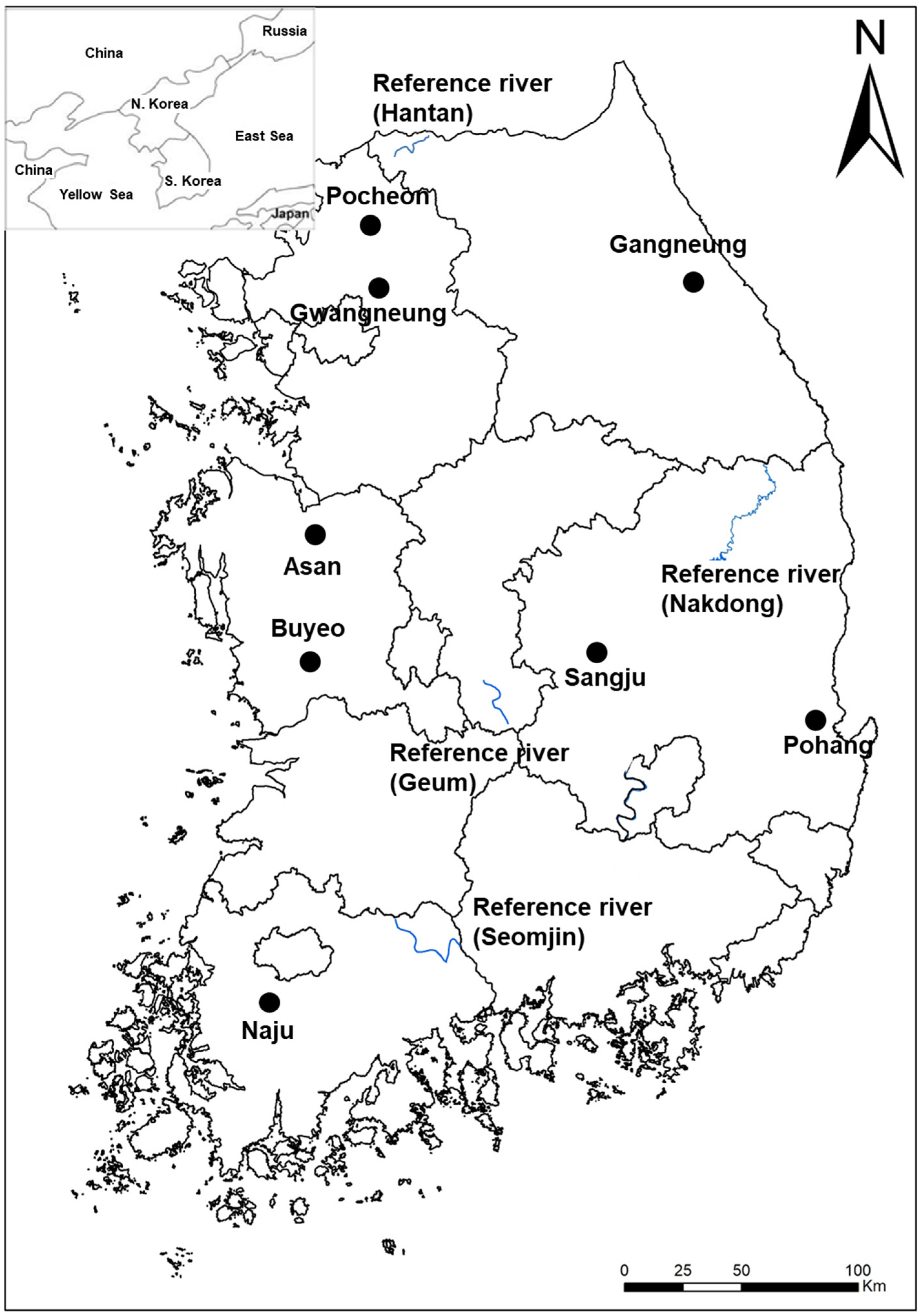
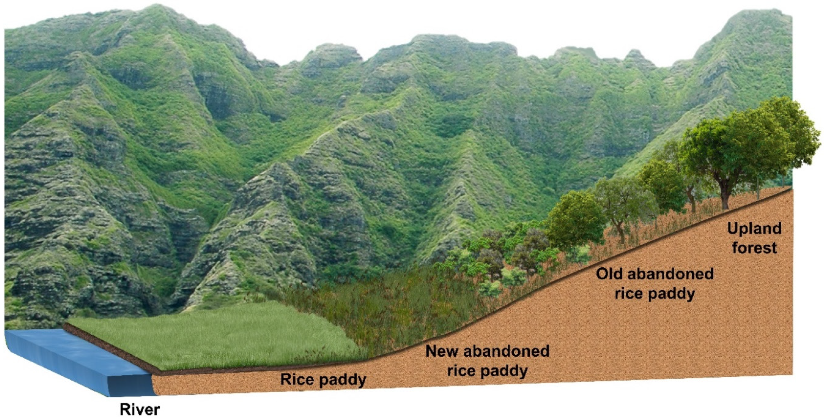
2.1. Site Description

The abandoned rice paddies studied were selected from eight areas across the national territory of South Korea (Figure 1). The survey area was first divided into western and eastern regions, and then each divided into northern, central, and southern regions, and selected evenly from each of those six regions. Pocheon and Gwangneung, Asan and Buyeo, Naju, Gangneung, Sangju, and Pohang were selected as survey sites in the northwest, west-central, southwest, northeast, east-central, and southeast regions, respectively.
The successional stages of the survey areas tended to be early stage, dominated by herbaceous plants, mid-stage, dominated by shrubby plants and young trees, and late stage, dominated by trees. Because abandonment of rice paddies began from a place away from the residential area, the successional stage tended to be determined by distance from residential area (Figure 2).
Sites for surveying reference conditions for riparian vegetation were selected in the Hantan River, Cheolwon, Gangwon Province, the Geum River, Youngdong, Chungbuk Province, the Seomjin River, Gurye, Jeonnam Province, and the Nakdong River, from Taebaek, Gangwon Province, to Andong, Gyungbuk Province (Figure 1). The Hantan River, Geum River, Seomjin River, and Nakdong River were selected for comparison with the abandoned rice paddies located in the northwest, central-west, southwest, and eastern regions, respectively.
The Hantan River is located close to the DMZ (Demilitarized Zone) between South and North Korea and thereby has relatively intact riparian vegetation, which appears in the order of grassland, shrubland, and forest as the distance from the waterway increases. The upstream reach of the Geum River, the midstream reach of the Seomjin River, and the upstream reach of the Nakdong River are located on the remote areas that have escaped excessive artificial interferences and thus retain relatively integrate riparian vegetation like the aforementioned Hantan River.
The land use pattern of the watershed of each river reach was analyzed to prove that the conservation condition of the river selected to investigate riparian vegetation is good (Table 1). The geographical location of the surveyed reach is shown in Table 2.

2.2. Vegetation Survey

All plant species growing in each plot were identified, following Lee [55], Park [56], and the Korean Plant Names Index [57]. The vegetation survey was carried out by recording the cover class of plant species appearing in quadrats of 2 m × 2 m, 5 m × 5 m, and 20 m × 20 m size in grassland-, shrub-, and tree-dominated stands, respectively, installed randomly in the abandoned rice paddies and the riparian zone of each river reach selected for study [9]. The vegetation survey for the abandoned rice fields was carried out in 20, 38, 34, 94, 20, 13, 43, and 54 plots in Pocheon, Gwangneung, Asan, Buyeo, Naju, Gangneung, Sangju, and Pohang, respectively. The survey for the riparian vegetation was carried out in 35, 60, 24, and 28 plots in the Hantan, Geum, Seomjin, and Nakdong Rivers, respectively. Plant cover was recorded applying the Braun-Blanquet [58] scale. Each ordinal cover scale was converted to the median value of percent cover range in each cover class. Relative coverage was determined by dividing the cover fraction of each species by the summed cover of all species in each plot and then multiplying 100 to the value. Relative coverage was regarded as the importance value of each species [59]. A matrix of importance values for all species in all plots was constructed and used as data for ordination using detrended correspondence analysis [60]. Differences in species composition depending on successional stage in the abandoned rice paddy and between the abandoned rice field and riparian landscape were compared applying the ordination method.
Vegetation stratification was prepared by depicting the profile of stand spread in a belt transect of 10 m breadth for the abandoned rice fields and rivers selected for the study.

2.3. Systematization of Collected Vegetation Data into Reference Information

The data collected in the abandoned rice fields of the early, mid, and late stages, which are dominated by herbs, shrubs, and trees, could be compared to the grassland, shrubland, and forest of riparian vegetation, respectively. Therefore, to use the data as the reference information for river restoration, the data were systematized by reflecting the spatial distribution of the riparian vegetation.
Reference information of vegetation was first prepared by depicting the vegetation profile, which expresses the successional stages in the abandoned rice paddies and the spatial distribution of the riparian vegetation. Furthermore, the information for species composition was also systematized by classifying into the riparian zone, which reflects the flooding disturbance regime.

2.4. Statistical Analyses

Ordination was carried out based on data obtained from the abandoned rice field, riparian vegetation, and by synthesizing both datasets. Detrended correspondence analysis (DCA) was applied to reveal the difference and similarity between species composition of plant communities occurring with the progress of succession in the abandoned rice field (through time) and as a function of distance from the waterfront of the riparian vegetation (through space). Ordination was performed using PC-Ord 4.0 [61].

3. Results

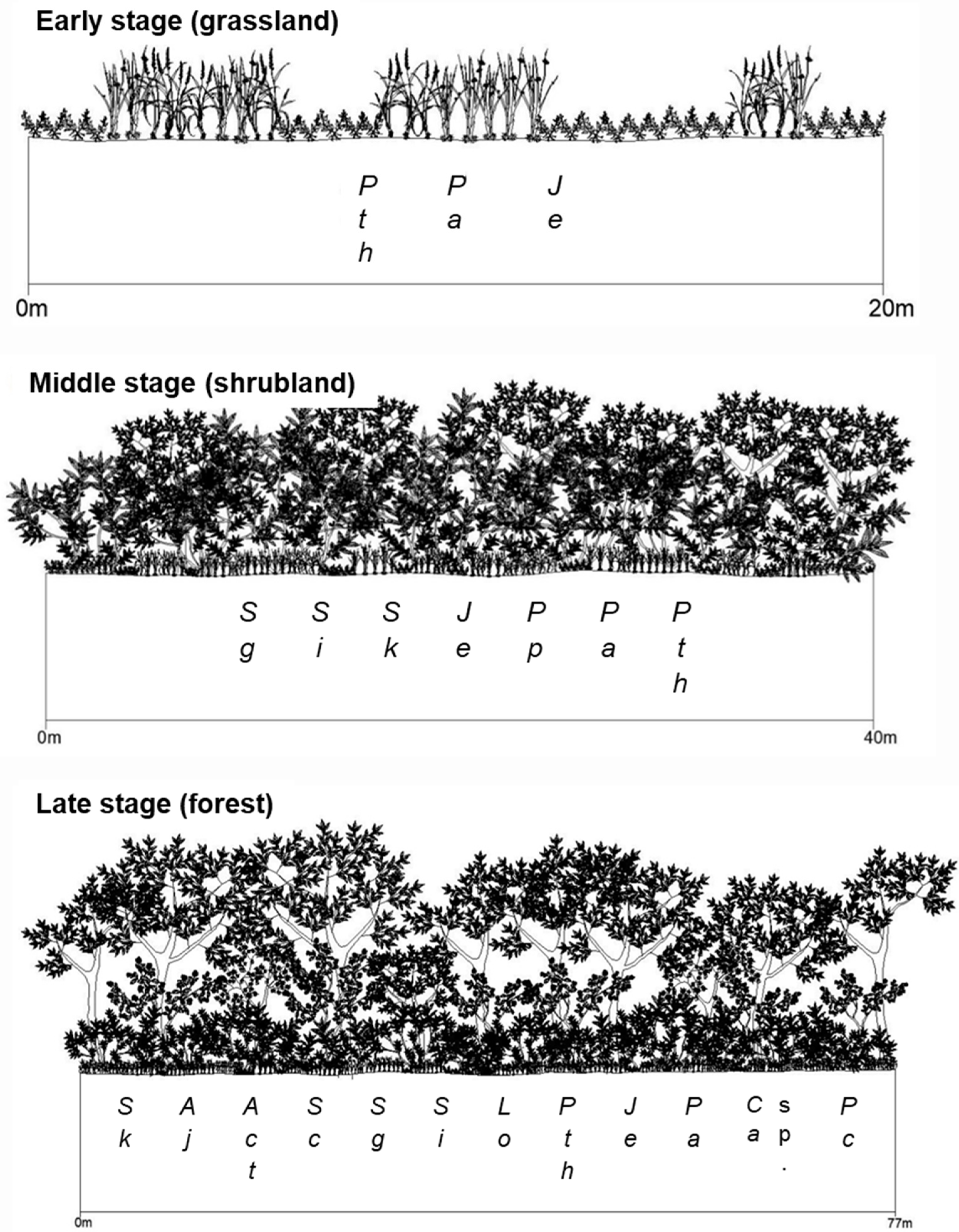
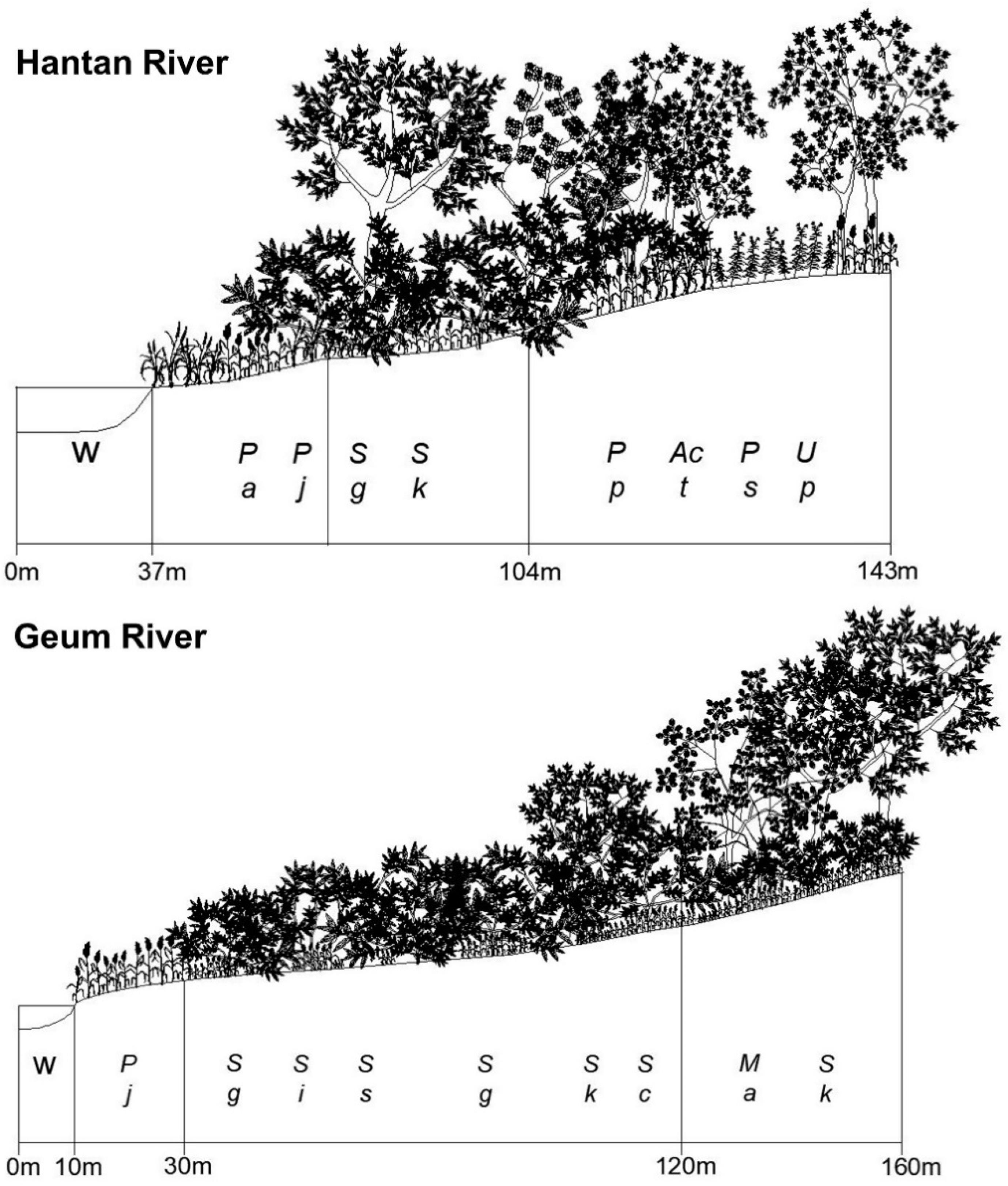
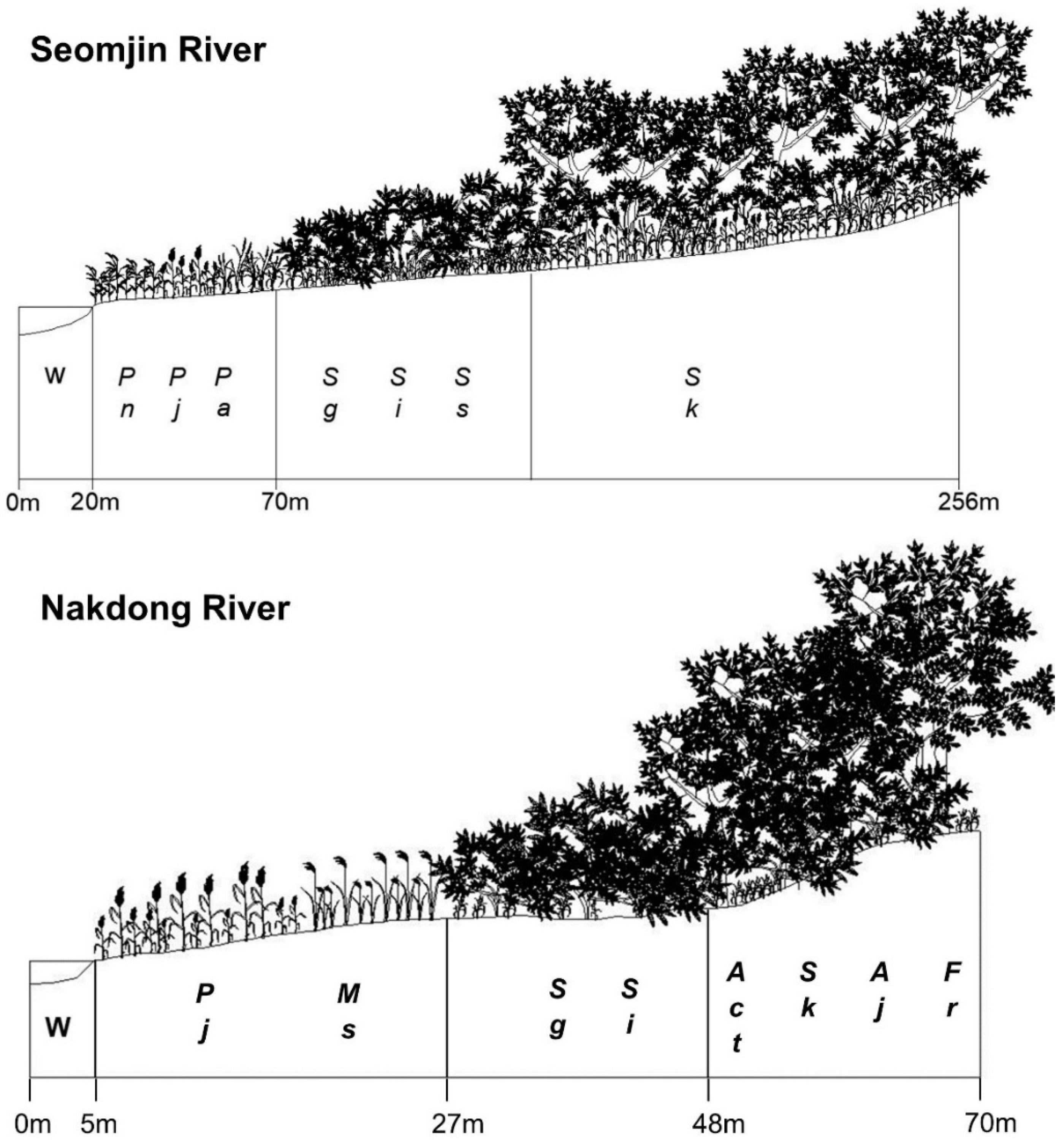
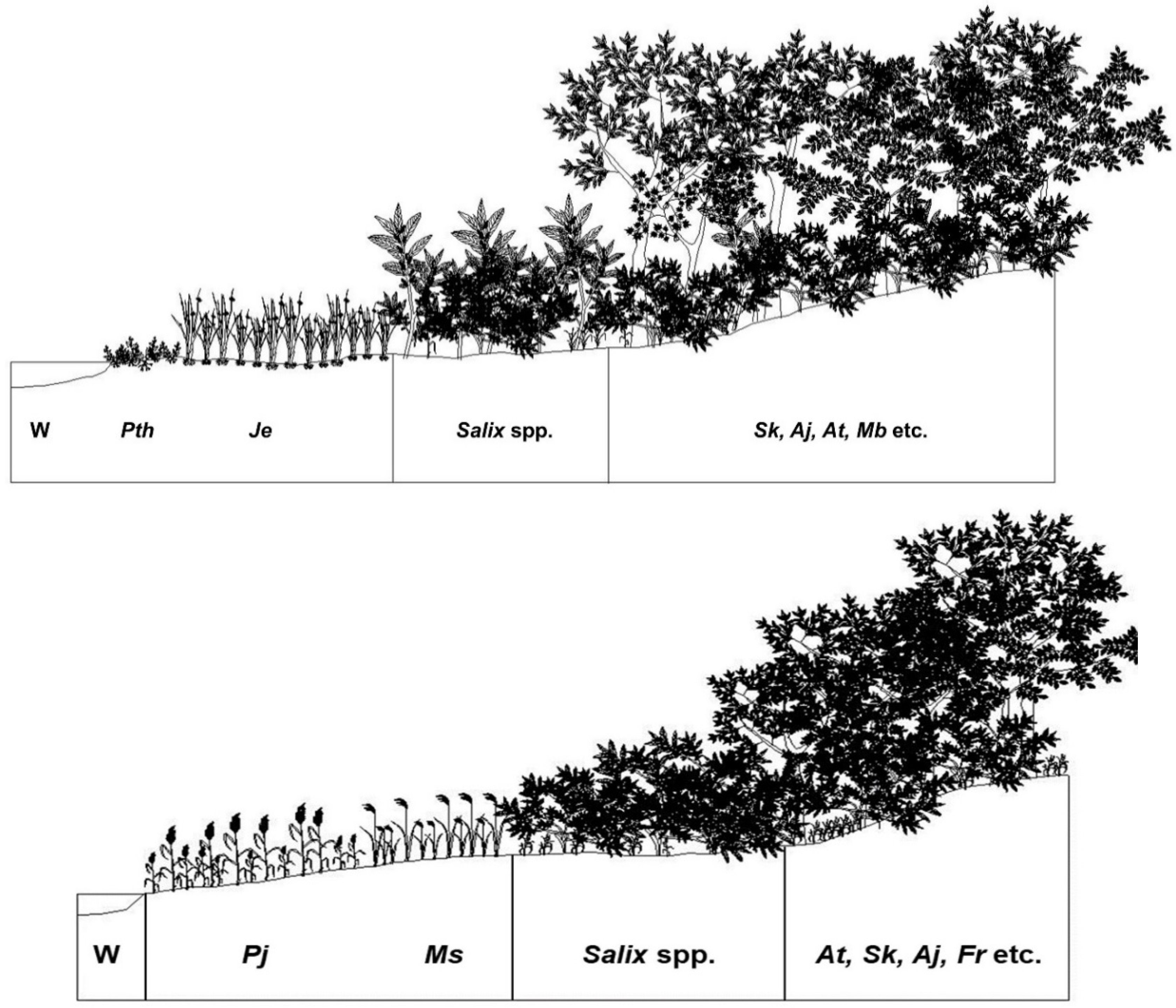
3.1. Successional Stages of the Abandoned Rice Fields Expressed as Stand Profile

Stand profiles of the vegetation surveyed in the abandoned rice fields in different successional stages are shown in Figure 3. The abandoned rice field of the early successional stage stays in the grassland stage, which is composed of a Persicaria thunbergii community, Juncus effuusus var. decipiens community, Phalaris arundinacea community, and so on. The abandoned rice field of the mid-successional stage is in the shrubland stage, which is dominated by Salix gracilistyla community, Salix integra community, and young Salix koreensis community. On the other hand, the abandoned rice field of the late successional stage maintains a forest, which is composed of an S. koreensis community, Salix chaenomeloides community, Alnus japonica community, and Acer tataricum subsp. ginnala community (Figure 3).
Dominant plant communities by successional stage in each survey area for abandoned rice paddies are summarized in Table 3.

3.2. Changes in Species Composition Depending on Successional Stages

The results of stand ordination based on vegetation data obtained from the abandoned rice fields are shown in Figure 4. In one northwestern region (Pocheon, Gyunggi-do), stands tended to be arranged in the order of J. effuusus var. decipiens community, P. thunbergii community, P. arundinacea community, and S. koreensis community, moving from the right to left parts on Axis I (Figure 4).
In another northwestern region (Gwangneung, Gyunggi-do), stands tended to be arranged in the order of J. effuusus var. decipiens community, P. thunbergii community, S. koreensis community, A. japonica community—A. tataricum subsp. ginnala community—S. chaenomeloides community, and Fraxinus rhynchophylla community, moving from the right to left parts on Axis I (Figure 4).
In one central western region (Asan, Chungcheongnam-do), stands tended to be arranged in the order of J. effuusus var. decipiens community, P. thunbergii community, P. arundinacea community, S. gracilistyla community, S. koreensis community—S. chaenomeloides community, and S. integra community, moving from the left to right parts on Axis I (Figure 4).
In another central western region (Buyeo, Chungcheongnam-do), stands tended to be arranged in the order of Leersia japonica community, P. thunbergii community—S. gracilistyla community, S. integra community, and S. koreensis community, moving from the right to left parts on Axis I (Figure 4).
In the southwestern region (Naju, Jeollanam-do) (Figure 4), stands tended to be arranged in the order of J. effuusus var. decipiens community, P. thunbergii community—S. koreensis community, and S. chaenomeloides community moving from the right to left parts on Axis I (Figure 4). From these results, the difference in species composition among communities could be confirmed, but the trend of succession among communities could not be confirmed.
In the northeastern region (Gangneung, Gangwon-do), stands tended to be arranged in the order of S. gracilistyla community, P. thunbergii community, Juncus effuusus var. decipiens community, and S. koreensis community, moving from the right to left parts on Axis I (Figure 4).
In the central eastern region (Sangju, Gyungsangbuk-do) (Figure 4), stands tended to be arranged in the order of P. thunbergii community, S. gracilistyla community–J. effuusus var. decipiens community, and S. koreensis community, moving from the right to left parts on Axis I (Figure 4).
In the southeastern region (Pohang, Gyungsangbuk-do), stands tended to be arranged in the order of Typha orientalis community, P. thunbergii community, S. integra community, and S. koreensis community, moving from the left to right parts on Axis I (Figure 4).
These results usually reflected the successional trend as a change from herbaceous plant-dominated vegetation through shrub-dominated vegetation to tree-dominated vegetation, except for the Naju site.

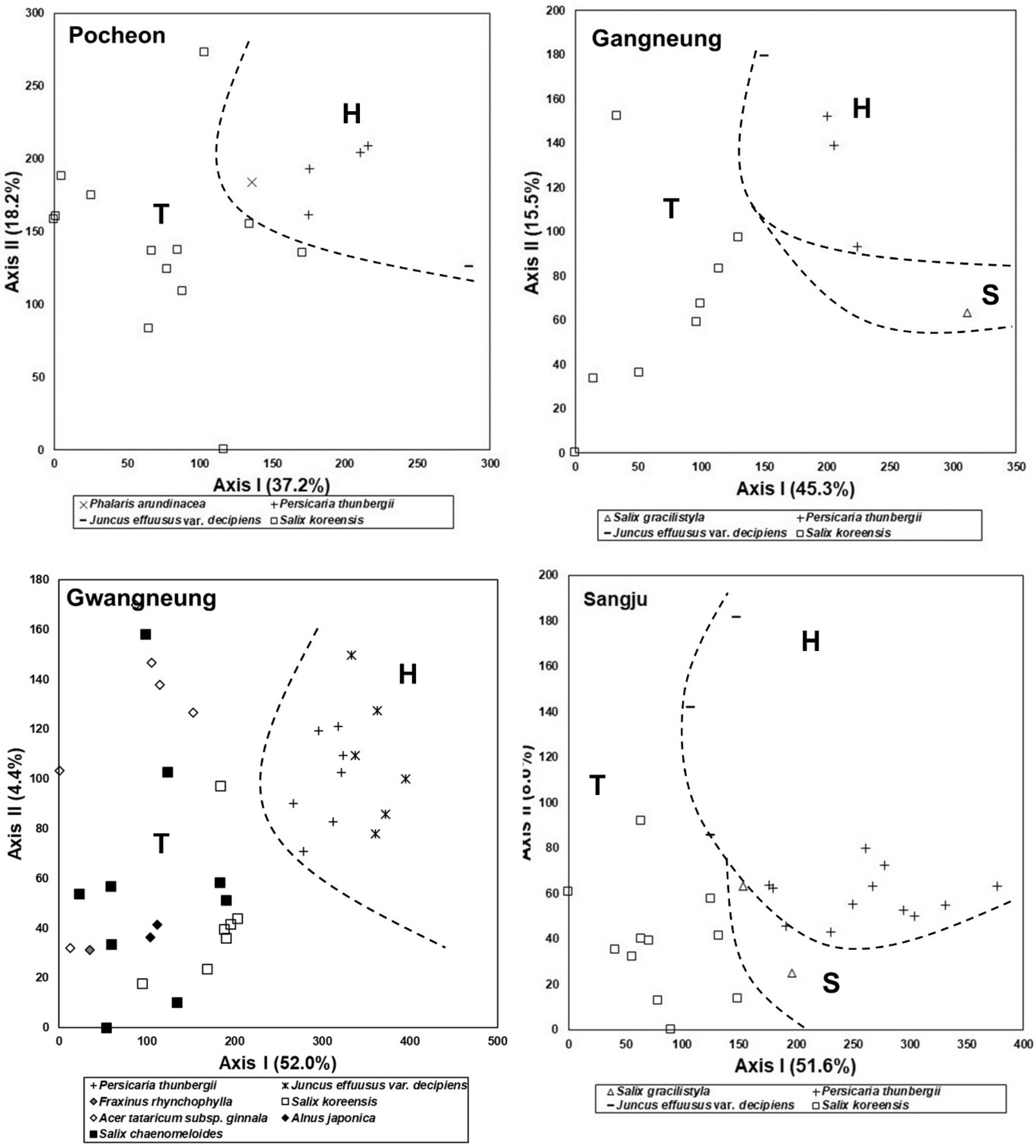
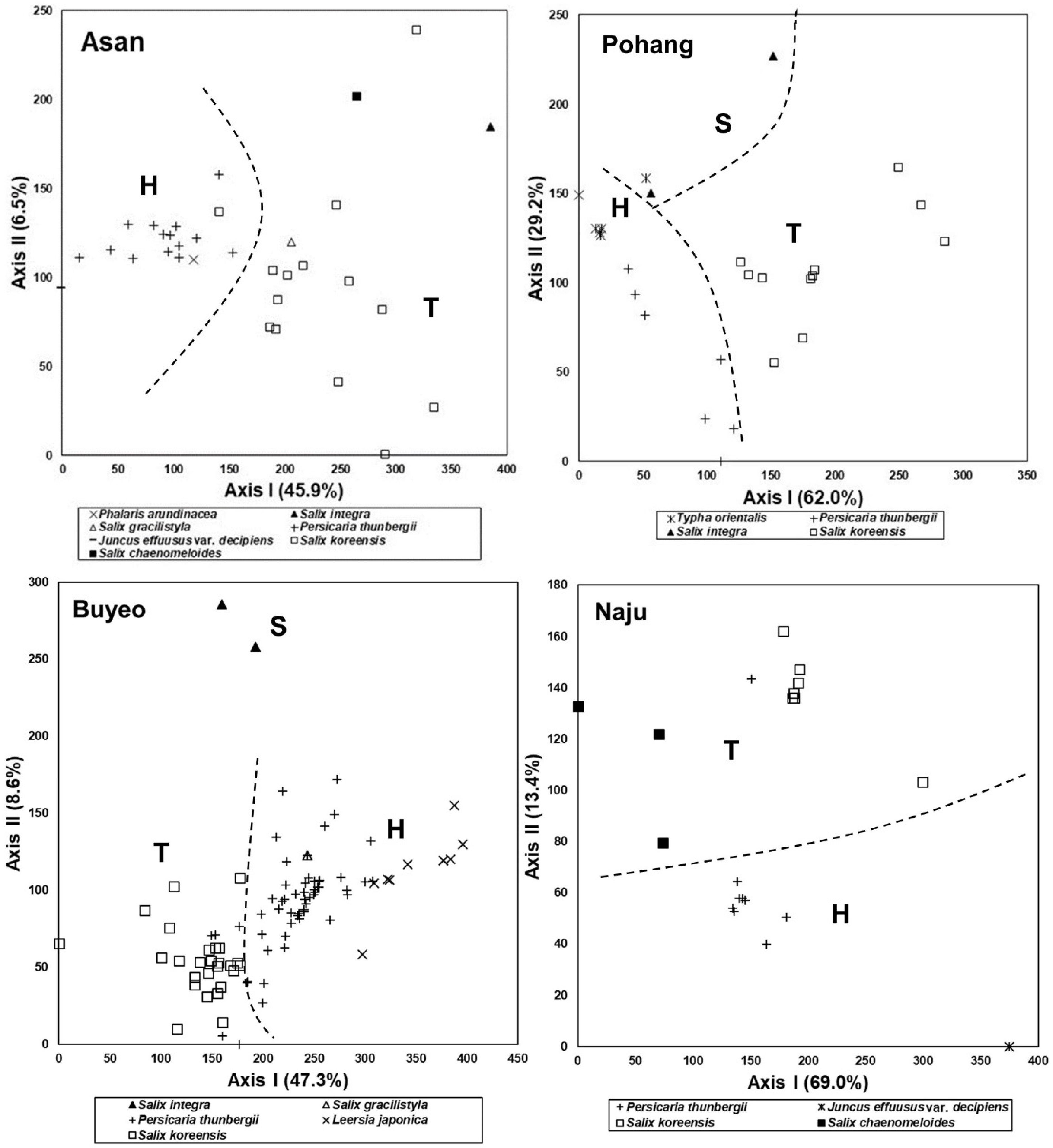
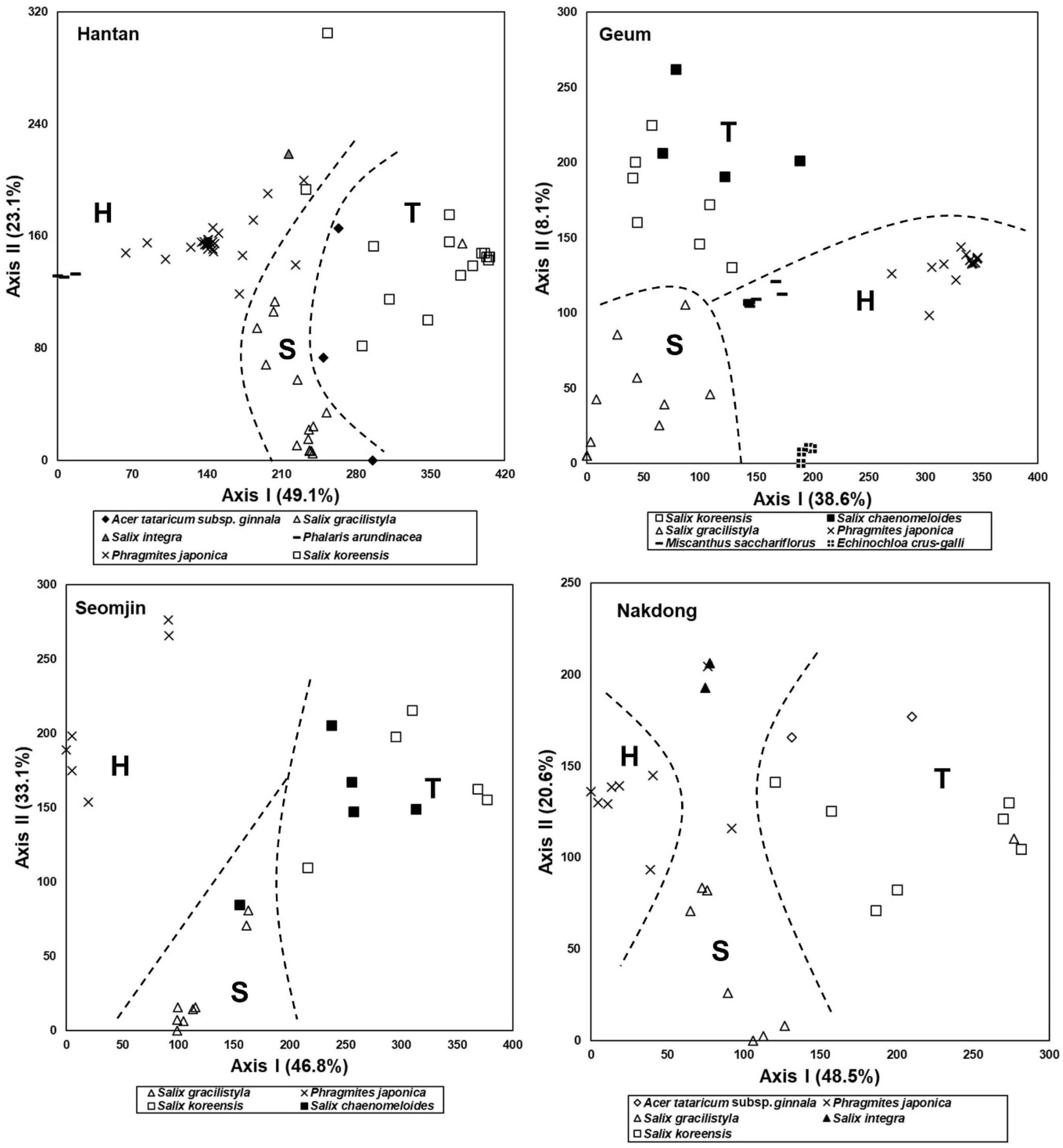
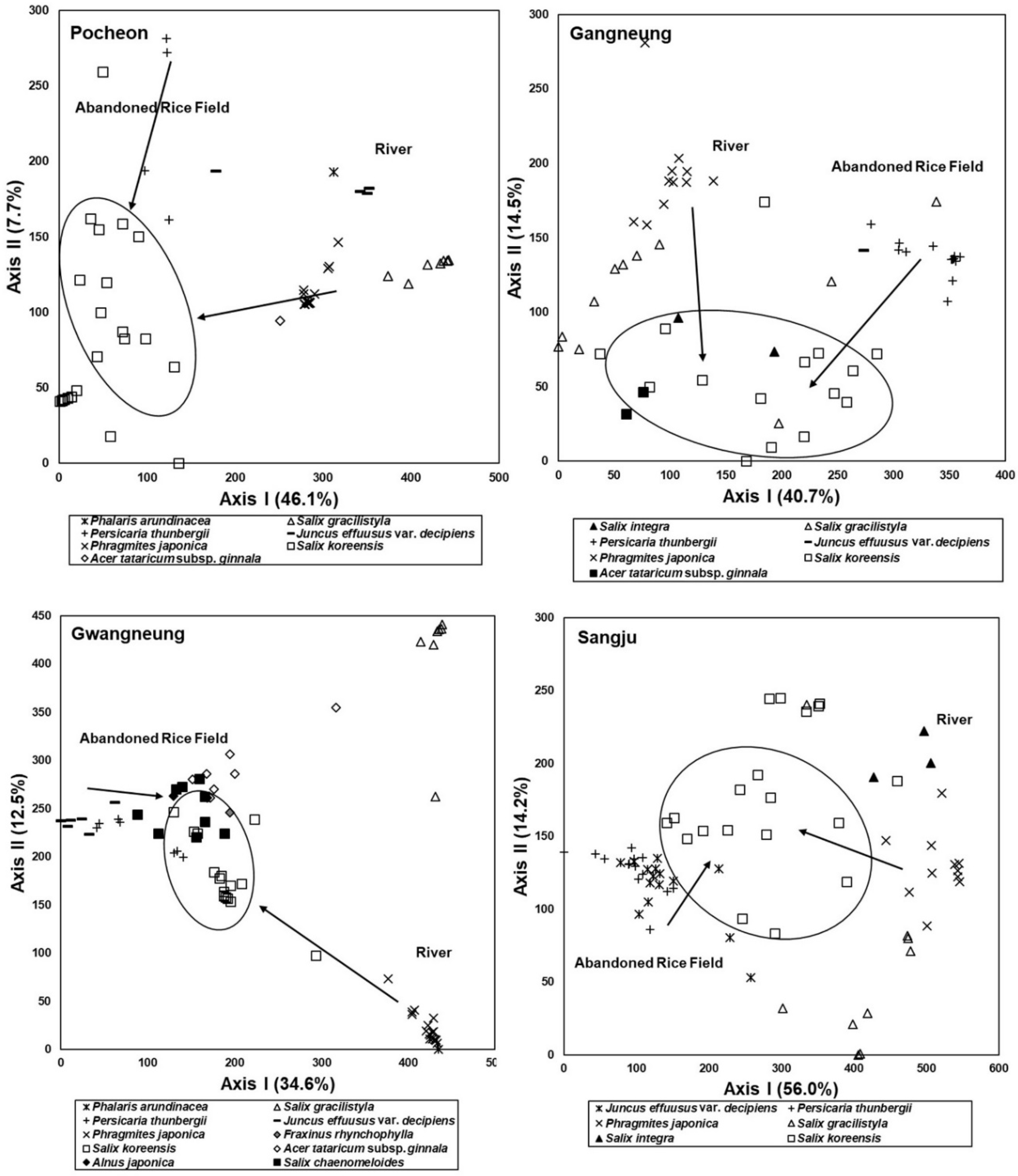
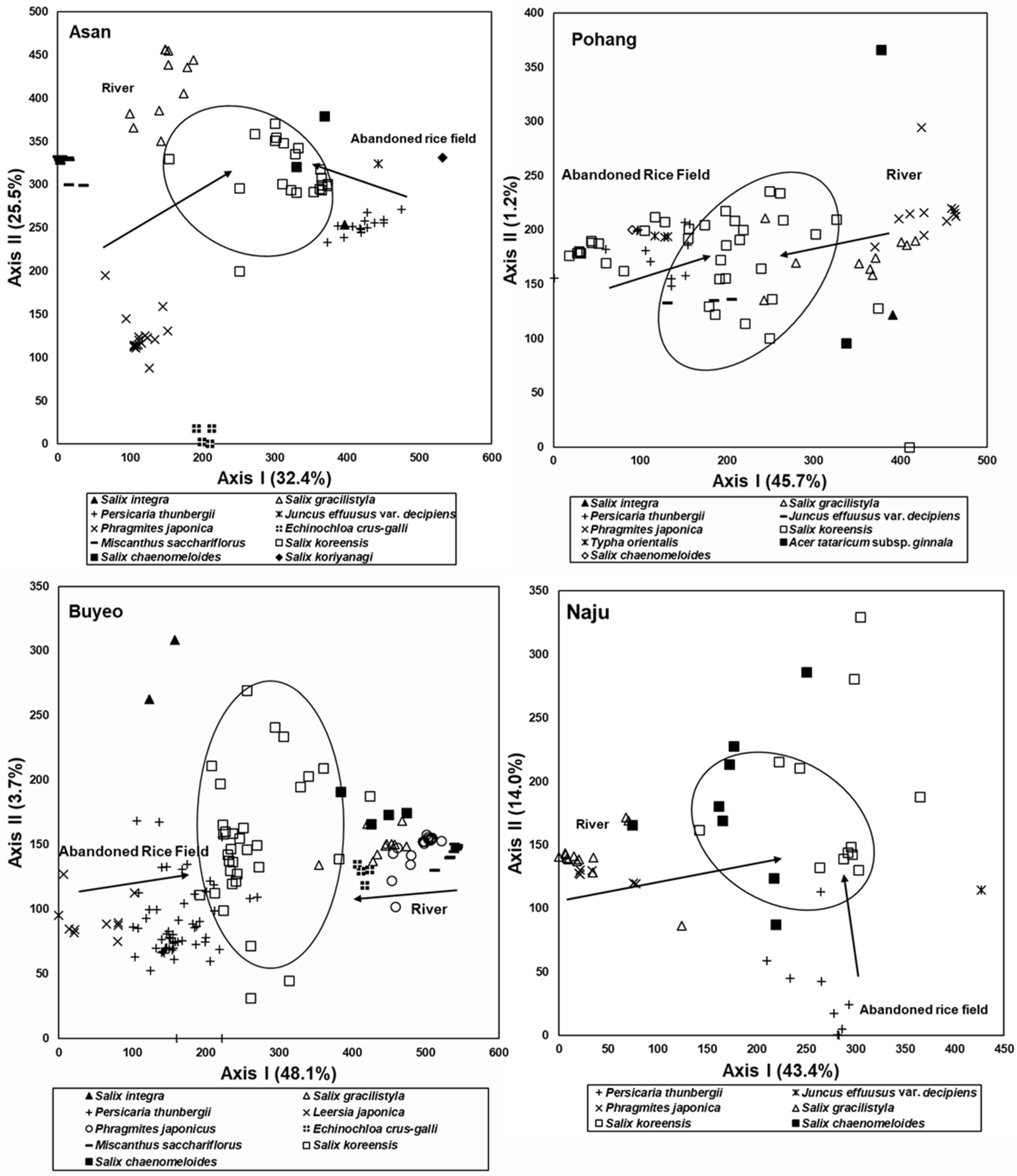
3.3. Spatial Distribution of the Riparian Vegetation Based on Stand Profile

Stand profiles of riparian vegetation collected from the Hantan River, Geum River, Seomjin River, and Nakdong River are shown in Figure 5. Riparian vegetation established in those four rivers appeared in the order of grassland, shrubland, and forest as the distance from the waterway increased, and thus tended to reflect the flooding disturbance regime. In the Hantan River, Phragmites japonica community and P. arundinacea community dominated the grassland zone. The shrub zone was dominated by S. gracilistyla community and S. integra community. S. koreensis community, Prunus padus community, and Ulmus pumila community dominated the forest zone (Figure 5).
In the Geum River, P. japonica, Phragmites communis, Miscanthus sacchariflorus, P. arundinacea, etc., dominated the grassland zone. S. gracilistyla, S. integra, Salix subfragilis, young S. koreensis, etc., dominated the shrubland zone, and S. koreensis, S. chaenomeloides, Morus alba, etc., dominated the forest zone (Figure 5).
In the Seomjin River, Persicaria nodosa, P. japonica, M. sacchariflorus, P. arundinacea, Humulus japonicas, etc., dominated the grassland zone. S. gracilistyla, S. integra, S. subfragilis, young S. koreensis, etc., dominated the shrubland zone, and S. koreensis, S. chaenomeloides, Morus alba, etc., dominated the forest zone (Figure 5).
In the Nakdong River, a P. japonica community and a mixed community of P. japonica and S. gracilistyla dominated the grassland zone. The shrubland zone was dominated by S. gracilistyla, Carex dimorpholepis, A. tataricum subsp. ginnala, etc., and Salix koreensis, A. tataricum subsp. ginnala, Juglans mandshurica, F. rhynchophylla, etc., dominated the forest zone (Figure 5).

3.4. Species Composition of the Riparian Vegetation

The results of stand ordination based on the riparian vegetation data obtained from the Hantan River, Geum River, Seomjin River, and Nakdong River are shown in Figure 6. In the Hantan River, stands tended to be arranged in the order of a P. arundinacea community, P. japonica community, S. gracilistyla community, S. integra community, Acer tattarium subsp. ginnala community, and S. koreensis community from the left to right parts on the Axis I, and thus reflected the typical spatial distribution of the riparian vegetation (Figure 6).
In the Geum River, stands tended to be arranged in the order of a P. japonica community, Echinochloa crus-galli community, M. sacchariflorus community, and S. gracilistyla community—S. koreensis community—S. chaenomeloides community, from the right to left parts on Axis I, and S. gracilistyla community, S. koreensis community, and S. chaenomeloides community were arranged in the mentioned order from the lower to upper parts on Axis II (Figure 6).
In the Seomjin River, stands tended to be arranged in the order of a P. japonica community, S. gracilistyla community, S. chaenomeloides community, and S. koreensis community from the left to right parts on Axis I (Figure 6).
In the Nakdong River, stands tended to be arranged in the order of a P. japonica community, S. gracilistyla community–S. integra community, and A. tataricum subsp. ginnala community–S. koreensis community from the left to right parts on Axis I (Figure 6).

3.5. Comparison of Species Composition between Vegetation in the Abandoned Rice Fields and the Riparian Vegetation

As a result of ordination based on vegetation data obtained from both the abandoned rice paddies and riparian zones, the arrangement of stands of the abandoned rice fields reflected successional change over years after abandonment, and that of the riparian vegetation stands reflected the spatial distribution pattern (Figure 7). In the results, stands of plant communities established in the early successional stage of the abandoned rice fields and grassland zone of the rivers, such as P. japonica, P. thunbergia, and J. effuses var. decipiens communities, tended to be arranged far away from each other (Figure 7). However, stands established away from the waterfront in the riparian zone and stands established in the abandoned rice paddy of the late successional stage with long abandonment history were located close to each other (Figure 7). That is, there was a difference in species composition between the vegetation of the early successional stage in the abandoned rice paddy and the herbaceous plant-dominated vegetation established near the waterway in the riparian zone. However, the vegetation of both sites tended to be similar to each other as the succession progressed in the abandoned rice paddy and the distance from the waterfront increased in the riparian zone (Figure 7).

3.6. Feasibility of Vegetation Data Obtained from the Abandoned Rice Fields as Reference Information for Restoration of the Riparian Vegetation

The result of ordination based on vegetation data obtained from the abandoned rice fields and the riparian vegetation implies that species composition of vegetation established in the abandoned rice paddy of the early successional stage was different from that in the grassland zone of the riparian vegetation (Figure 7). However, species composition of vegetation established in the old abandoned rice fields resembled that of riparian vegetation established in the zones far from the waterfront (Figure 7). These results show that vegetation of the early successional stage in the abandoned rice fields differs from that of the grassland zone of the riparian vegetation, but the vegetation that appears as the succession progresses resembles that of the tree-dominated zone of riparian vegetation.
Considering these facts, we recommend Salix spp. including S. gracilistyla, S. integra, etc., which form the mid-successional stage of the abandoned rice paddy, and S. koreensis, A. tataricum subsp. ginnala, A. japonica, and Morus bombycis, which form the late successional stage of the abandoned rice paddy, as the candidate plant species to create the shrubland and forest zones, respectively, of the riparian vegetation (Figure 8).
The reference information systematized by synthesizing the vegetation data collected from the riparian vegetation of the abovementioned four rivers was expressed as a stand profile (Figure 8). P. japonica and M. sacchariflorus, Salix spp. including S. gracilistyla, Salix integra, etc., and S. koreensis, A. tataricum subsp. ginnala, F. rhynchophylla, Alnus japonica, etc., dominated the grassland-, shrubland-, and tree-dominated forest zones, respectively.
Comparing both vegetation profiles, those from the grassland portions of the abandoned rice paddies and the riparian zone differed, but shrub-dominated and tree-dominated zones were very similar (Figure 8).

4. Discussion

4.1. The Significance and Value of a Study on Succession

A study on succession was begun from characterizing successional patterns describing the chronosequence of vegetation along sand dunes on the shores of Lake Michigan, moving from bare sand beach, to grasslands, to mature forests [62]. A description of changes in species composition over time in old fields forms a backbone of successional studies. Abandoned fields offer several advantages for ecological research because they are worldwide, and thus allow comparison of the results from various geographical regions [10]. Therefore, Rejmanek [10] viewed old fields as a sort of ‘Drosophila’ for a study on terrestrial ecology, particularly succession.
Succession is as central to ecology as evolution in biology [63]. The study of succession covers the concepts and tools of ecosystem, community, population, and species ecology, soil science, geology, meteorology, conservation biology, and other disciplines. It has attracted human attention over the centuries and has gradually become a model for habitat restoration [29,64]. Succession has played an important role in the formation of theory and concept of ecology in the past because it represents the recovery and development of ecosystems after disruption, and today it provides significant information required for the restoration of disturbed land [8,64,65].
The study of succession, how biological communities are reorganized after natural or artificial disturbances, has become the basis of ecology and theoretical frameworks that underpin many fields of study [1,22,66,67]. Although succession is sometimes recognized as a classical theme, recent research and reviews have shown that succession continues to play a central role in modern ecological theory and applications. For example, our understanding of succession is included in theories on the combination of community and coexistence of species [68,69,70], as well as development, restoration ecology, and global change ecology [71,72]. In this regard, succession can certainly function as the basis of modern ecology.
Succession refers to a directional, predictable change in community structure over time (Figure 3 and Figure 4, [4,73]). This change is due to shifts in the presence and relative abundance of different species as time passes over years to centuries. In plant communities, succession begins when an area is made partially or completely devoid of vegetation due to a disturbance [74]. Vegetation types in a given site have been and are shaped by a suite of disturbance types that vary in both their spatial extent and frequency of recurrence [75]. The integration of disturbance events over time and space is known as disturbance regimes, and they can be characterized in a variety of ways. That is, disturbance regimes vary in extent, spatial distribution, frequency, and recurrence interval depending on the environmental conditions [76,77,78,79].
Rice fields are a kind of disclimax that has been maintained for a long time due to continuous human interference. When cultivation is stopped in these rice paddies, a succession proceeds in which the structure and species composition of vegetation change over time after abandonment [29]. Disclimax refers to the plant communities in progress of succession formed under the influence of the frequency and intensity of disturbance, that is, the disturbance regime [79,80]. Disclimax is a relatively stable ecological community often including kinds of organisms foreign to the region and displacing the climax because of disturbance, especially by humans.
Riparian ecosystems are dynamic systems found in flood-prone areas along rivers. They represent the transition between the aquatic and terrestrial ecosystems [81] and play a decisive role in riverine integrity [82]. Riparian ecosystems rely greatly on the characteristics of the flow regime (e.g., [83]) and are notably susceptible to flow regime changes (e.g., [84]). The natural inter- and intra-annual variability of the flow regime determines the highly variable fluvial disturbances to which riparian vegetation respond structurally in the medium to long term [85]. Therefore, fluvial disturbances, i.e., the disruption imposed by the seasonal sequence of river flooding and drying (particularly their intensity and spatial extent), are the main drivers of the ecological succession of riparian vegetation [86]. That is, fluvial disturbances control the creation, development, and recycling of vegetation patches [87]. Fluvial disturbances, especially floods, are the main drivers of the successional patterns of riparian vegetation. Those disturbances control the riparian landscape dynamics through the direct interaction between flow and vegetation [88]. The spatial distribution of riparian vegetation types in different developmental stages reflects the disturbance regime (Figure 5 and Figure 6).

4.2. Relationship between Vegetation Sere in Abandoned Rice Fields and Spatial Distribution of Riparian Vegetation

In Korea, abandonment of rice paddies was a rare phenomenon in the past, but we were able easily find a number of rice paddies abandoned at different times, as the abandonment has become more common.
A sere of plant communities on abandoned rice fields was started by grassland dominated by herbaceous plants, which are usually established around the pool based on the waterway and in the marginal subzone based on the riparian ecosystem [89]. The older rice paddies dominated by shrubby willows such as S. gracilistyla, S. integra, or young S. koreensis were structurally analogous to the lower subzone (shrubland) in the riparian ecosystem (Figure 3 and Figure 5). The old abandoned rice fields with well-developed tree layers resemble the riparian forest, which is established in the upper subzone [90,91] of the riparian ecosystem. Vegetation of the old abandoned rice fields is composed of S. koreensis, S. chaenomeloides, A. japonica, A. tataruim subsp. ginnala, etc. (Figure 3 and Figure 5). Riparian vegetation of the tree-dominated upper zone is composed of S. koreensis, S. chaenomeloides, A. japonica, A. tataruim subsp. ginnala, F. rhynchophylla, U. pumila, etc. (Figure 5 and Figure 6), and thus shows similar species composition to those of the old abandoned rice paddies (Figure 7 and Figure 8).

4.3. Spatial Range of River as a Landscape

All river systems contain three distinct, lateral riparian zones, namely marginal, lower, and upper zones. The zones are identified by disturbance regime, that is, a combination of the periodicity of the hydrological influence, marked changes in lateral elevation or moisture gradients, changes in geomorphic structure, and changes in plant species distribution or community composition along lateral gradients [90,91,92].
The marginal zone is the lowest zone and is always present in river systems, while the other two zones may not always be present. The zone is situated from the water level at low flow, if present, up to the features that are hydrologically activated for most of the year. The marginal zone along this section of the river is relatively small and rarely extends for more than one meter from the water front. The marginal zone in this section does not contain a large amount of vegetation. This is primarily due to the sandy sediment and the constant disturbance and deposition of sediment in the marginal zone. The marginal zone is also often eroded away by the river. Therefore, the riparian community is currently in a poor state [90,91].
The lower zone may be accompanied by a change in species distribution patterns. The lower zone consists of geomorphic features that are activated on a seasonal basis. The lower zone along this section of the river contains a steep slope but is subjected to annual flooding. The riparian vegetation in this zone consists primarily of grasses and herbs. The lower zone is also encroached by shrubby willows such as S. gracilistyla and S. integra (Figure 5 and Figure 8). These shrubs are adapted to the high moisture regime and annual floods [90,91].
The upper zone is characterized by ephemeral features as well as the presence of both riparian and terrestrial species. The zone extends from the lower zone to the riparian corridor. The upper zone contains geomorphic features that are hydrologically activated on an ephemeral basis. The upper zone along this section of the river contains a steep slope that contains a marked decrease in lateral slope. The upper zone is usually dominated by trees such as S. koreensis, S. chaenomeloides, A. tataricum subsp. ginnala, A. japonica, and so on. This zone is considered severely degraded gradients [90,91].
The riverine landscape is comprised of the stream and riparian ecosystems. When water flows in stream ecosystems over a bank, riparian ecosystems are formed [90]. A riparian ecosystem is an ecotone between aquatic and terrestrial ecosystems that consists of several fluvial surfaces, including channel islands and bars, channel banks, floodplains, and lower terraces. Goodwin et al. [90] divided the riparian ecosystem into two zones, but it becomes three zones, including bare ground (marginal zone). Zone 1, which corresponds to the lower zone, is frequently inundated, affected by the current fluvial geomorphic processes, and is at elevations that allow shallow-rooted plants to extract water from the water table. Zone 2, which corresponds to the upper zone, is formed by past fluvial geomorphic processes and is higher in elevation than surfaces in Zone 1, and deep-rooted plants can extract water from the underlying alluvial aquifer dominate vegetation. However, Zones 1 (lower zone) and 2 (upper zone) are not always present in all sections of a river corridor and the separation between them is not always distinct, often existing along a continuum rather than as a sharp boundary. Riparian vegetation, which appears in the order of grassland, shrubland, and forest depending on the distance from the waterway, is determined by different disturbance regimes depending on the topographic condition of the riparian zone [90,91]. In this respect, the sequence of vegetation corresponds to a toposequence and at the same time a chronosequence.
That the temporal sequence of vegetation change identified in abandoned rice paddies after abandonment resembled the spatial distribution of the riparian vegetation could be evidence that such rice paddies were made by transforming riparian zones. In fact, in the DMZ, where human interference was limited for more than 70 years after the Korean War, the former rice fields were covered with riparian vegetation [92].

4.4. Land Use Pattern and Actual Status of Rivers in Korea

Korea has a high population density (https://www.worlddata.info/population-density.php, accessed on 15 July 2022). Rice, a wetland plant, is used as a staple food, but 65% of the country’s land is mountainous, making it difficult to secure farmland to cultivate it. Rice farming in Korea has more than 5000 years of history [93].
In countries where rice is used as a staple food such as Korea, a significant portion of the riparian zone, which is a part of the riverine landscape, has been used as rice paddies. In addition, these riparian zones have been developed into cities, and we can see this fact from the soil of the urban area, the alluvial soil [32,92,94,95].
Since its use for rice paddies, the rivers have been narrowed to secure as much land as possible, and embankments have been built high to prevent flood damage. Therefore, most of the rivers in Korea have very narrow riparian ecosystems, and it is hard to find a river that has a complete spatial range [92,96].
In the Demilitarized Zone and Civilian Control Zone, which were left in the natural process for 70 years after the Korean War, abandoned rice paddies restored to riparian vegetation. According to the changes in the landscape structure of the Suip stream basin in Yanggu, Gangwon-do, which flows through the Demilitarized Zone and the Civilian Control Zone, over the past 70 years, some rice paddies in the area have remained intact, but the ones in the Demilitarized Zone and the Civilian Zone have turned into riparian vegetation [92].
By ecologically evaluating the actual conditions of the rivers in Korea, the flow diversity is low due to the drop in sinuosity due to the effects of channelization. As a result, diversity of micro-topography in waterways is reduced, and thus ecological diversity is also low. The cross-sections of most rives maintain a double terrace structure, and thereby the connectivity between the stream ecosystem and the riparian ecosystem is not natural. This double terraced structure also reduces the surface area of river channels, adding to the risk of flooding along with reducing the width of rivers due to excessive land use. Furthermore, this greatly changed the ecological characteristics of vegetation established there, influencing the water table and the disturbance regime. The high proportion of obligate upland and exotic plants in riparian vegetation zones reflects this fact. In addition to the reduction in the width and cross-sectional area of the river, these vegetation changes become aggravation factors in the reduction in the surface area of the river channel and flooding risk [34,97,98,99].

4.5. Necessity for Riparian Restoration

Succession is a process in which the disturbed ecosystem develops toward a state before it is disturbed through natural processes [1,2]. In the abandoned rice paddies, the fact that the vegetation of the late successional stage resembles the species composition of plant communities established in the zone far from the waterway in the spatial distribution of riparian vegetation proves that location of these paddy fields was originally riparian zones.
A map showing land use patterns in Korea represents that these rice paddies are extensively distributed along the river. From these results, it could be confirmed that the width of Korean rivers was greatly reduced. Nevertheless, as recreational use increases in the remaining river spaces, the cross-section of the river changes to a double terraced structure, and the river is experiencing a reduction in the volume of the riverine structure again [97].
In the river whose width has been greatly reduced in this way, it is expected that a risk of flooding would increase. Moreover, rivers in Korea belonging to the monsoon climate are exposed to the risk of flooding every year, and the problem is even more serious as extreme weather events become more frequent and the intensity increases due to climate change [100,101].
In this reality, ecological restoration is urgently required in the direction of securing the original spatial range of rivers whose width has been greatly reduced [102]. In fact, river restoration projects in advanced countries reflect this trend [103,104,105,106,107]. The room for the river project represents such river restoration [108]. When promoting such ecological restoration, the ecological information secured through this study could be used to set the spatial range to be secured, and furthermore, the secured vegetation information could be used as reference vegetation information required to practice the restoration.

5. Conclusions

Today, riparian areas are treated as one of the very important ecosystems, but most riparian landscapes in Korea have been transformed into rice paddies and urban areas. Consequently, the riparian ecosystems were destroyed or degraded and thereby the river’s extent was reduced and function was simplified. In this respect, it is urgently required to restore the degraded or destroyed riparian ecosystems due to excessive land use. However, rapid environmental changes including climate change require systematic restoration to ensure stability as well as to expand the spatial extent of rivers.
In Korea, following the global trend, river restoration projects are being carried out, but the ecological quality of the streams has not improved as the principle of ecological restoration was not adhered to. In particular, the reference information, which should be a model in ecological restoration plans and a guideline for evaluation after restoration projects, is not utilized. Information on the ecological location of abandoned rice fields obtained from this study could contribute to expanding the spatial extent of river restoration in the future. Furthermore, information on vegetation obtained in the process is expected to serve as reference information in the future, which will contribute to improving the quality of river restoration.

Author Contributions

Conceptualization, C.S.L.; methodology, B.S.L.; validation, J.H.A. and A.R.K.; formal analysis, J.H.A. and A.R.K.; investigation, C.S.L., J.H.A., A.R.K., J.S., B.S.L. and C.H.L.; data curation, J.S. and B.S.L.; writing—original draft preparation, B.S.L.; writing—review and editing, C.S.L. and B.S.L.; visualization, C.H.L. All authors have read and agreed to the published version of the manuscript.

Funding

This research received no external funding.

Conflicts of Interest

The authors declare no conflict of interest.

References

  1. Prach, K.; Walker, L.R. Four opportunities for studies of ecological succession. Trends Ecol. Evol. 2011, 26, 119–123. [Google Scholar] [CrossRef] [PubMed]
  2. Burton, P.J.; Jentsch, A.; Walker, L.R. The ecology of disturbance interactions. BioScience 2020, 70, 854–870. [Google Scholar] [CrossRef]
  3. Christensen, N.L.; Peet, R.K. Convergence during secondary forest succession. J. Ecol. 1984, 72, 25–36. [Google Scholar] [CrossRef]
  4. Huston, M.; Smith, T. Plant succession: Life history and competition. Am. Nat. 1987, 130, 168–198. [Google Scholar] [CrossRef]
  5. Pickett, S.T.A.; Collins, S.L.; Armesto, J.J. Models, mechanisms and pathways of succession. Bot. Rev. 1987, 53, 335–371. [Google Scholar] [CrossRef]
  6. Turner, M.G.; Baker, W.L.; Peterson, C.J.; Peet, R.K. Factors influencing succession: Lessons from large, infrequent natural disturbances. Ecosystems 1998, 1, 511–523. [Google Scholar] [CrossRef]
  7. Young, T.P.; Chase, J.M.; Huddleston, R.T. Community succession and assembly: Comparing, contrasting and combining paradigms in the context of ecological restoration. Ecol. Restor. 2001, 19, 5–18. [Google Scholar] [CrossRef]
  8. Chang, C.C.; Turner, B.L. Ecological succession in a changing world. J. Ecol. 2019, 107, 503–509. [Google Scholar] [CrossRef] [Green Version]
  9. Ellenberg, D.; Mueller-Dombois, D. Aims and Methods of Vegetation Ecology; Wiley: New York, USA, 1974. [Google Scholar]
  10. Rejmánek, M. Vegetation ecology matures in its homeland. Ecology 1990, 71, 2399–2400. [Google Scholar] [CrossRef]
  11. Glenn-Lewin, D.C.; Van Der Maarel, E. Patterns and processes of vegetation dynamics. In Plant Succession Theory Prediction; DC Glenn-Lewin, D.C., Peet, R.K., Veblen, T.T., Eds.; Chapman and Hall: London, UK, 1992; pp. 11–59. [Google Scholar]
  12. Rejmánek, M.; van Katwyk, K.P. Old Field Succession: A Bibliographic Review (1901–1991); University of California: Davis, CA, USA, 2005. [Google Scholar]
  13. Pickett, S.T.A. Population patterns through twenty years of oldfield succession. Vegetatio 1982, 49, 45–59. [Google Scholar] [CrossRef]
  14. Bazzaz, F.A.; Chiariello, N.R.; Coley, P.D.; Pitelka, L.F. Allocating resources to reproduction and defense. BioScience 1987, 37, 58–67. [Google Scholar] [CrossRef] [Green Version]
  15. Goldberg, D.E. Neighborhood competition in an old-field plant community. Ecology 1987, 68, 1211–1223. [Google Scholar] [CrossRef]
  16. Inouye, R.S.; Tilman, D. Convergence and divergence of old-field plant communities along experimental nitrogen gradients. Ecology 1988, 69, 995–1004. [Google Scholar] [CrossRef]
  17. Schmidt, W. An experimental study of old-field succession in relation to different environmental factors. Vegetatio 1988, 77, 103–114. [Google Scholar] [CrossRef]
  18. Osbornová, J.; Kovárová, M.; Leps, J.; Prach, K. Succession in Abandoned Fields: Studies in Central Bohemia, Czechoslovakia; Springer Science & Business Media: Berlin, Germany, 1990; Volume 15. [Google Scholar]
  19. Holt, R.D.; Robinson, G.R.; Gaines, M.S. Vegetation dynamics in an experimentally fragmented landscape. Ecology 1995, 76, 1610–1624. [Google Scholar] [CrossRef]
  20. Cramer, V.A.; Hobbs, R.J.; Standish, R.J. What’s new about old fields? Land abandonment and ecosystem assembly. Trends Ecol. Evol. 2008, 23, 104–112. [Google Scholar] [CrossRef]
  21. Martínez-Duro, E.; Ferrandis, P.; Escudero, A.; Luzuriaga, A.L.; Herranz, J.M. Secondary old-field succession in an ecosystem with restrictive soils: Does time from abandonment matter? Appl. Veg. Sci. 2010, 13, 234–248. [Google Scholar] [CrossRef]
  22. Meiners, S.J.; Cadotte, M.W.; Fridley, J.D.; Pickett, S.T.A.; Walker, L.R. Is successional research nearing its climax? New approaches for understanding dynamic communities. Funct. Ecol. 2015, 29, 154–164. [Google Scholar] [CrossRef]
  23. Shimoda, M.; Suzuki, H. Vegetation of fallow rice fields in the Saijo Basin, Hiroshima Prefecture, Japan, Japan. Hikobia Suppl. 1981, 1, 321–339. [Google Scholar]
  24. Shimoda, M. Abandoned rice field vegetation and its evaluation, A case study of wet abandoned rice field vegetation in Hiroshima Prefecture. Veg. Sci. 1996, 13, 37–50. [Google Scholar]
  25. Kim, J.W.; Nam, H.K. Syntaxonomical and synecological characteristics of rice field vegetation. Korean J. Ecol. 1998, 21, 203–215. [Google Scholar]
  26. Cao, J.; Li, M.; Deo, R.C.; Adamowski, J.F.; Cerdà, A.; Feng, Q.; Liu, M.; Zhang, J.; Zhu, G.; Zhang, X.; et al. Comparison of social-ecological resilience between two grassland management patterns driven by grassland land contract policy in the Maqu, Qinghai-Tibetan Plateau. Land Use Policy 2018, 74, 88–96. [Google Scholar] [CrossRef] [Green Version]
  27. Hong, M.G.; Park, H.; Nam, B.E.; Kim, J.G. Vegetational characteristics of abandoned paddy terraces in comparison with natural and constructed wetlands. J. Wetl. Res. 2019, 21, 199–206. [Google Scholar]
  28. Haripal, K.; Sahoo, S. Vegetational dynamics in some tropical abandoned rice fields in the western part of Orissa, India. Afr. J. Environ. Sci. Technol. 2011, 5, 37–44. [Google Scholar]
  29. Lee, C.; You, Y.; Robinson, G.R. Secondary succession and natural habitat restoration in abandoned rice fields of central Korea. Restor. Ecol. 2002, 10, 306–314. [Google Scholar] [CrossRef]
  30. Yoon, J.; Nam, J.M.; Kim, H.; Bae, Y.J.; Kim, J.G. Nannophya pygmaea (odonata: Libellulidae), an endangered dragonfly in Korea, prefers abandoned paddy fields in the early seral stage. Environ. Entomol. 2010, 39, 278–285. [Google Scholar] [CrossRef]
  31. Shimoda, S.; Wagai, R. Ecosystem dynamics after abandonment of rice paddy fields: Does alien plant invasion enhance carbon storage? Ecosystems 2020, 23, 617–629. [Google Scholar] [CrossRef]
  32. Lee, C.S.; Cho, Y.C.; Shin, H.C.; Moon, J.S.; Lee, B.C.; Bae, Y.S.; Byun, H.G.; Yi, H.B. Ecological response of streams in Korea under different management regimes. Water Eng. Res. 2005, 6, 131–147. [Google Scholar]
  33. Lee, C.S.; Lee, H.; Kim, A.R.; Pi, J.H.; Bae, Y.J.; Choi, J.K.; Lee, W.S.; Moon, J.S. Ecological effects of daylighting and plant reintroduction to the Cheonggye stream in Seoul, Korea. Ecol. Eng. 2020, 152, 105879. [Google Scholar] [CrossRef]
  34. Lim, C.H.; Pi, J.H.; Kim, A.R.; Cho, H.J.; Lee, K.S.; You, Y.H.; Lee, K.H.; Kim, K.D.; Moon, J.S.; Lee, C.S. Diagnostic evaluation and preparation of the reference information for river restoration in South Korea. Int. J. Environ. Res. Public Health 2021, 18, 1724. [Google Scholar] [CrossRef]
  35. Lee, C.S.; Hong, S.K.; You, Y.H.; Kim, J.E.; Moon, J.S. Landscape structure in the green belt around the metropolitan area of Seoul, Korea. In Proceedings of the IAVS Symposium, Uppsala, Sweden, 23–28 July 2000; pp. 230–233. [Google Scholar]
  36. Lee, C.S.; Moon, J.S.; Kim, J.E. Landscape changes caused by forest fire and vegetation regeneration processes. In Proceedings of the IAVS Symposium, Uppsala, Sweden, 23–28 July 2000; pp. 99–103. [Google Scholar]
  37. Ok, Y.H. Changes of Soil Properties, Species Diversity and r-K Selection in Early Stage of Old-Field Succession; Seoul National University: Seoul, Korea, 1984. [Google Scholar]
  38. Ku, Y.B. Test of Connell and Slatyer’s Model by the Litter Treatment in Early Abandoned Field Succession; Seoul National University: Seoul, Korea, 1994. [Google Scholar]
  39. Lee, K.S.; Kim, J.H. Seral changes in environmental factors and recovery of soil fertility during abandoned field succession after shifting cultivation. Korean J. Ecol. 1995, 18, 243–253. [Google Scholar]
  40. Lee, K.S.; Kim, J.H. Seral changes in floristic composition during abandoned field succession after shifting cultivation. Korean J. Ecol. 1995, 18, 275–283. [Google Scholar]
  41. Lee, C.S.; Yon, Y.H. Ecological consideration for restoration of the degraded urban river. Korean J. Ecol. 2002, 25, 247–252. [Google Scholar] [CrossRef]
  42. Ferreira, L.V.; Stohlgren, T.J. Effects of river level fluctuation on plant species richness, diversity, and distribution in a floodplain forest in Central Amazonia. Oecologia 1999, 120, 582–587. [Google Scholar] [CrossRef]
  43. Casanova, M.T.; Brock, M.A. How do depth, duration and frequency of flooding influence the establishment of wetland plant communities? Plant Ecol. 2000, 147, 237–250. [Google Scholar] [CrossRef]
  44. Vandersande, M.W.; Glenn, E.P.; Walworth, J.L. Tolerance of five riparian plants from the lower Colorado River to salinity drought and inundation. J. Arid. Environ. 2001, 49, 147–159. [Google Scholar] [CrossRef]
  45. Parolin, P. Submergence tolerance vs. escape from submergence: Two strategies of seedling establishment in Amazonian floodplains. Environ. Exp. Bot. 2002, 48, 177–186. [Google Scholar] [CrossRef]
  46. Xiaoling, L.; Ning, L.; Jin, Y.; Fuzhou, Y.; Faju, C.; Fangqing, C. Morphological and photosynthetic responses of riparian plant Distylium chinense seedlings to simulated Autumn and Winter flooding in Three Gorges Reservoir Region of the Yangtze River, China. Acta Ecol. Sin. 2011, 31, 31–39. [Google Scholar] [CrossRef]
  47. Blom, C.W.P.M.; Voesenek, L.A.C.J. Flooding: The survival strategies of plants. Trends Ecol. Evol. 1996, 11, 290–295. [Google Scholar] [CrossRef] [Green Version]
  48. Shafroth, P.B.; Stromberg, J.C.; Patten, D.T. Riparian vegetation response to altered disturbance and stress regimes. Ecol. Appl. 2002, 12, 107–123. [Google Scholar] [CrossRef]
  49. Auble, G.T.; Scott, M.L.; Friedman, J.M. Use of individualistic streamflow-vegetation relations along the Fremont River, Utah, USA to assess impacts of flow alteration on wetland and riparian areas. Wetlands 2005, 25, 143–154. [Google Scholar] [CrossRef]
  50. Capon, S.J. Flood variability and spatial variation in plant community composition and structure on a large arid floodplain. J. Arid. Environ. 2005, 60, 283–302. [Google Scholar] [CrossRef]
  51. Bornette, G.; Tabacchi, E.; Hupp, C.; Puijalon, S.; Rostan, J.-C. A model of plant strategies in fluvial hydrosystems. Freshw. Biol. 2008, 53, 1692–1705. [Google Scholar] [CrossRef] [Green Version]
  52. Hauer, F.R.; Dahm, C.N.; Lamberti, G.A.; Stanford, J.A. Landscapes and ecological variability of rivers in North America: Factors affecting restoration strategies. In Strategies for Restoring River Ecosystems: Sources of Variability and Uncertainty in Natural and Managed Systems; Wissmar, R.C., Bisson, P.A., Eds.; American Fisheries Society: Bethesda, MD, USA, 2003; pp. 81–105. [Google Scholar]
  53. Stanford, J.A.; Lorang, M.S.; Hauer, F.R. The shifting habitat mosaic of river ecosystems. SIL Proc. 2005, 29, 123–136. [Google Scholar] [CrossRef]
  54. Lorang, M.S.; Whited, D.C.; Hauer, F.R.; Kimball, J.S.; Stanford, J.A. Using airborne multispectral imagery to evaluate geomorphic work across floodplains of gravel-bed rivers. Ecol. Appl. 2005, 15, 1209–1222. [Google Scholar] [CrossRef] [Green Version]
  55. Lee, T.B. Illustrated Flora of Korea; HyangMoonSa: Seoul, Korea, 1985. [Google Scholar]
  56. Park, S.-H. Colored Illustrations of Naturalized Plants of Korea; Ilchokak: Seoul, Korea, 1995; p. 371. [Google Scholar]
  57. Korea National Arboretum. Korean Plant Names Index. Available online: http://www.nature.go.kr/kbi/plant/pilbk/selectPlantPilbkGnrlList.do (accessed on 15 July 2022).
  58. Braun-Blanquet, J. Pflanzensoziologie: Grundzüge der Vegetationskunde; Springer: Berlin, Germany, 1964. [Google Scholar]
  59. Curtis, J.T.; McIntosh, R.P. An upland forest continuum in the prairie-forest border region of wisconsin. Ecology 1951, 32, 476–496. [Google Scholar] [CrossRef]
  60. Hill, M.O.; Gauch, H.G. Detrended Correspondence Analysis: An Improved Ordination Technique. In Classification and Ordination: Symposium on Advances in Vegetation Science, Nijmegen, The Netherlands, May 1979; van der Maarel, E., Ed.; Springer: Dordrecht, The Netherland, 1980; pp. 47–58. [Google Scholar]
  61. McCune, B.; Mefford, M.J. PC-ORD, Multivariate Analysis of Ecological Data; Version 4; MjM Software Design: Glenden Beach, OR, USA, 1999. [Google Scholar]
  62. Cowles, H.C. The ecological relations of the vegetation on the sand dunes of lake Michigan. Part I.-geographical relations of the dune floras. Bot. Gaz. 1899, 27, 95–117. [Google Scholar] [CrossRef] [Green Version]
  63. Margalef, R. Perspectives in Ecological Theory; University of Chicago Press: Chicago, IL, USA, 1968. [Google Scholar]
  64. Walker, L.R. Linking Restoration and Ecological Succession; Walker, L.R., Joe, W., Hobbs, R.J., Eds.; Springer: London, UK, 2007. [Google Scholar]
  65. Christensen, N.L. An historical perspective on forest succession and its relevance to ecosystem restoration and conservation practice in North America. For. Ecol. Manag. 2014, 330, 312–322. [Google Scholar] [CrossRef]
  66. Egerton, F.N. History of ecological sciences, part 54: Succession, community, and continuum. Bull. Ecol. Soc. Am. 2015, 96, 426–474. [Google Scholar] [CrossRef] [Green Version]
  67. Walker, L.R.; Wardle, D.A. Plant succession as an integrator of contrasting ecological time scales. Trends Ecol. Evol. 2014, 29, 504–510. [Google Scholar] [CrossRef]
  68. Chang, C.; HilleRisLambers, J. Integrating succession and community assembly perspectives. F1000Research 2016, 5. [Google Scholar] [CrossRef] [PubMed]
  69. Pérez-Hernández, J.; Gavilán, R.G. Impacts of land-use changes on vegetation and ecosystem functioning: Old-field secondary succession. Plants 2021, 10, 990. [Google Scholar] [CrossRef]
  70. Pulsford, S.A.; Lindenmayer, D.B.; Driscoll, D.A. A succession of theories: Purging redundancy from disturbance theory. Biol. Rev. 2016, 91, 148–167. [Google Scholar] [CrossRef]
  71. Kim, A.R.; Lim, B.S.; Seol, J.; Lee, C.S. Principle of restoration ecology reflected in the process creating the national institute of ecology. J. Ecol. Environ. 2021, 45, 12. [Google Scholar] [CrossRef]
  72. Méndez-Toribio, M.; Martínez-Garza, C.; Ceccon, E. Challenges during the execution, results, and monitoring phases of ecological restoration: Learning from a country-wide assessment. PLoS ONE 2021, 16, e0249573. [Google Scholar] [CrossRef]
  73. Grime, J.P. Plant Strategies, Vegetation Processes; Wiley: New York, NY, USA, 1979. [Google Scholar]
  74. Connell, J.H.; Slatyer, R.O. Mechanisms of succession in natural communities and their role in community stability and organization. Am. Nat. 1977, 111, 1119–1144. [Google Scholar] [CrossRef]
  75. Wyse, S.V.; Wilmshurst, J.M.; Burns, B.R.; Perry, G.L.W. New Zealand forest dynamics a review of past and present vegetation responses to disturbance, and development of conceptual forest models. N. Z. J. Ecol. 2018, 42, 87–106. [Google Scholar] [CrossRef] [Green Version]
  76. White, P.S. Pattern, process, and natural disturbance in vegetation. Bot. Rev. 1979, 45, 229–299. [Google Scholar] [CrossRef]
  77. White, P.S. Natural disturbance and patch dynamics: An introduction. In The Ecology Natural Disturbance and Patch Dynamics; Pickett, S.T.A., White, P.S., Eds.; Academic Press: Orland, FL, USA, 1985; pp. 3–13. [Google Scholar]
  78. White, P.S.; Harrod, J.; Walker, J.L.; Jentsch, A. Disturbance, scale, and boundary in wilderness management. In Proceedings of the Wilderness Science in a Time of Change Conference, Missoula, MT, USA, 23–27 May 1999; pp. 27–42. [Google Scholar]
  79. Lugo, A.E. Effects of extreme disturbance events: From ecesis to social–Ecological–Technological systems. Ecosystems 2020, 23, 1726–1747. [Google Scholar] [CrossRef] [Green Version]
  80. Kramer, K.; Brinkman, B.; Kuiters, L.; Verdonschot, P.F.M. Is Ecological Succession Predictable?: Theory and Applications; Alterra: Wageningen, The Netherland, 2005. [Google Scholar]
  81. Naiman, R.J.; Décamps, H. The ecology of interfaces: Riparian zones. Annu. Rev. Ecol. Syst. 1997, 28, 621–658. [Google Scholar] [CrossRef] [Green Version]
  82. Van Looy, K.; Tormos, T.; Ferréol, M.; Villeneuve, B.; Valette, L.; Chandesris, A.; Bougon, N.; Oraison, F.; Souchon, Y. Benefits of riparian forest for the aquatic ecosystem assessed at a large geographic scale. Knowl. Managt. Aquat. Ecosyst. 2013, 408, 06. [Google Scholar] [CrossRef] [Green Version]
  83. LeRoy, N.; Allan, J.D.; Bain, M.B.; Karr, J.R.; Prestegaard, K.L.; Richter, B.D.; Sparks, R.E.; Stromberg, J.C. The natural flow regime. BioScience 1997, 47, 769–784. [Google Scholar]
  84. Bejarano, M.D.; González del Tánago, M.; de Jalón, D.G.; Marchamalo, M.; Sordo-Ward, Á.; Solana-Gutiérrez, J. Responses of riparian guilds to flow alterations in a Mediterranean stream. J. Veg. Sci. 2012, 23, 443–458. [Google Scholar] [CrossRef] [Green Version]
  85. Whited, D.C.; Lorang, M.S.; Harner, M.J.; Hauer, F.R.; Kimball, J.S.; Stanford, J.A. Climate, hydrologic disturbance, and succession: Drivers of floodplain pattern. Ecology 2007, 88, 940–953. [Google Scholar] [CrossRef] [PubMed] [Green Version]
  86. Corenblit, D.; Tabacchi, E.; Steiger, J.; Gurnell, A.M. Reciprocal interactions and adjustments between fluvial landforms and vegetation dynamics in river corridors: A review of complementary approaches. Earth Sci. Rev. 2007, 84, 56–86. [Google Scholar] [CrossRef]
  87. Bendix, J.; Hupp, C.R. Hydrological and geomorphological impacts on riparian plant communities. Hydrol. Processes 2000, 14, 2977–2990. [Google Scholar] [CrossRef]
  88. Rivaes, R.; Pinheiro, A.N.; Egger, G.; Ferreira, T. The role of river Morphodynamic disturbance and groundwater hydrology as driving factors of riparian landscape patterns in Mediterranean rivers. Front. Plant Sci. 2017, 8, 1612. [Google Scholar] [CrossRef] [Green Version]
  89. Park, S.A.; Kim, G.S.; Pee, J.H.; Oh, W.S.; Kim, H.S.; Lee, C.S. Reference information for realizing ecological restoration of river: A case study in the Bongseonsa stream. J. Ecol. Environ. 2013, 36, 235–243. [Google Scholar] [CrossRef] [Green Version]
  90. Goodwin, C.N.; Hawkins, C.P.; Kershner, J.L. Riparian restoration in the western United States: Oveview and perspecive. Restor. Ecol. 1997, 5, 4–14. [Google Scholar] [CrossRef]
  91. van Rensburg, D. River Index of Habitat Integrity (IHI) and Riparian Vegetation Assessment for the Proposed Establishment of a Measuring Weir within the Caledon (Mohokare) River (Quaternary Drainage Region: D22D). Available online: https://sahris.sahra.org.za/sites/default/files/additionaldocs/Caledon%20IHI.pdf (accessed on 10 July 2022).
  92. An, J.H.; Lim, C.H.; Lim, Y.K.; Nam, K.B.; Lee, C.S. A review of restoration project evaluation and post management for ecological restoration of the river. J. Restor. Ecol. 2014, 4, 15–34. [Google Scholar]
  93. Ahn, S.M. The emergence of rice agriculture in Korea: Archaeobotanical perspectives. Archaeol. Anthropol. Sci. 2010, 2, 89–98. [Google Scholar] [CrossRef]
  94. Lee, C.S.; Cho, Y.C.; Shin, H.C.; Lee, S.M. Changes of landscape structure for the recent 20 years in the Wangsuk stream basin of the central Korea. J. Ecol. Environ. 2006, 29, 405–410. [Google Scholar] [CrossRef] [Green Version]
  95. Lim, C.H.; Jung, S.H.; Kim, A.R.; Kim, N.S.; Lee, C.S. Monitoring for changes in spring phenology at both temporal and spatial scales based on MODIS LST data in South Korea. Remote Sens. 2020, 12, 3282. [Google Scholar] [CrossRef]
  96. Jung, S.H.; Kim, A.r.; Seol, J.; Lim, B.S.; Lee, C.S. Characteristics and reference information of riparian vegetation for realizing ecological restoration classified by reach of the river in Korea. Korean Soc. Water Environ. 2018, 34, 447–461. [Google Scholar] [CrossRef]
  97. Kim, A.R.; Kim, D.U.; Lim, B.S.; Seol, J.; Lee, C.S. An evaluation on restoration effect in the restored Yangjae stream and the improvement plan based on the result. Korean J. Ecol. Environ. 2020, 53, 390–407. [Google Scholar] [CrossRef]
  98. Pi, J.H. The Evaluation of Impact of Dam Construction and Different Levels of Restoration on the Naturalness of Riparian Vegetation and Adaptive Management Plans for Improving the Naturalness of the Influenced Rivers of Restoration; Seoul Women’s University: Seoul, Korea, 2014. [Google Scholar]
  99. Pi, J.H. Construction of Vegetation Information of Reference River to Restore the Degraded River in Korean; Seoul Women’s University: Seoul, Korea, 2010. [Google Scholar]
  100. Tabari, H. Climate change impact on flood and extreme precipitation increases with water availability. Sci. Rep. 2020, 10, 13768. [Google Scholar] [CrossRef]
  101. Yamamoto, K.; Sayama, T.; Apip. Impact of climate change on flood inundation in a tropical river basin in Indonesia. Prog. Earth Planet. Sci. 2021, 8, 5. [Google Scholar] [CrossRef]
  102. Lee, C.S.; Jeong, Y.M.; Kang, H.S. Concept, direction, and task of ecological restoration. J. Restor. Ecol. 2011, 2, 59–71. [Google Scholar]
  103. Wohl, E.; Angermeier, P.L.; Bledsoe, B.; Kondolf, G.M.; MacDonnell, L.; Merritt, D.M.; Palmer, M.A.; Poff, N.L.; Tarboton, D. River restoration. Water Resour. Res. 2005, 41, 1–12. [Google Scholar] [CrossRef]
  104. Hesselink, A.W. History Makes a River. Man Induced Morphological Changes of the River Rhine and Its Implications for Future River Management in The Netherlands. In Proceedings of the 2nd International Workshop on River Environment, Ilsan, Korea, 26 June 2006; pp. 13–40. [Google Scholar]
  105. Fokkens, B. The Dutch Strategy for Safety and River Flood Prevention. In Extreme Hydrological Events: New Concepts for Security; Springer: Dordrecht, The Netherland; 2007, pp. 337–352.
  106. Seavy, N.E.; Gardali, T.; Golet, G.H.; Griggs, F.T.; Howell, C.A.; Kelsey, R.; Small, S.L.; Viers, J.H.; Weigand, J.F. Why climate change makes riparian restoration more important than ever: Recommendations for practice and research. Ecol. Restor. 2009, 27, 330–338. [Google Scholar] [CrossRef]
  107. Wohl, E.; Lane, S.N.; Wilcox, A.C. The science and practice of river restoration. Water Resour. Res. 2015, 51, 5974–5997. [Google Scholar] [CrossRef] [Green Version]
  108. Rijke, J.; van Herk, S.; Zevenbergen, C.; Ashley, R. Room for the river: Delivering integrated river basin management in the Netherlands. Int. J. River Basin Manag. 2012, 10, 369–382. [Google Scholar] [CrossRef]
Figure 1. A map showing the study areas. Information for the abandoned rice fields were collected from Pocheon, Gwangneung, Asan, Buyeo, Naju, Gangneung, Sangju, and Pohang. Information for the riparian vegetation was obtained from the midstream reach of the Hantan River, the upstream reach of the Geum River, the midstream reach of the Seomjin River, and the upstream reach of the Nakdong River where riparian vegetation is conserved well.
Ijerph 19 10416 g001
Figure 2. A schematic diagram showing the spatial distribution of the abandoned rice paddies and their different successional stages. Abandonment of rice paddy began in an inaccessible place away from the residential area, and the successional stage tended to be determined by the distance from residential area.
Ijerph 19 10416 g002
Figure 3. Stand profiles of vegetation investigated in the abandoned rice fields with different history. Act: Acer tataricum subsp. ginnala; Aj: Alnus japonica; Ca sp.: Carex sp.; Je: Juncus effusus var. decipiens; Lo: Ligustrum obtusifolium; Pa: Phalaris arundinacea; Pc: Phragmites communis; Pp: Persicaria perfoliata; Pth: Persicaria thunbergii; Sc: Salix chaenomeloides; Sg: Salix gracilistyla; Si: Salix integra; Sk: Salix koreensis.
Ijerph 19 10416 g003
Figure 4. DCA ordination of stands based on vegetation data collected from the abandoned rice fields of eight areas selected across the whole national territory of South Korea. Stands tended to be arranged in the order of herbaceous plant (H)-, shrub (S)-, and tree (T)-dominated stands on Axis I or II. Arrangement of stands reflected successional change over years after abandonment of the rice paddy.
Ijerph 19 10416 g004aIjerph 19 10416 g004b
Figure 5. Stand profiles of riparian vegetation collected from the Hantan River, Geum River, Seomjin River, and Nakdong River. Act: Acer tataricum subsp. ginnala; Aj: Alnus japonica; Cd: Carex dimorpholepis; Fr: Fraxinus rhynchophylla; Ma: Morus alba; Ms: Miscanthus sacchariflorus; Pa: Phalaris arundinacea; Pj: Phragmites japonica; Pn: Persicaria nodosa; Pp: Prunus padus; Ps: Polygonatum stenophyllum; Sc: Salix chaenomeloides; Sg: Salix gracilistyla; Si: Salix integra; Sk: Salix koreensis; Ss: Salix subfragilis; Up: Ulmus pumila; W: waterway.
Ijerph 19 10416 g005aIjerph 19 10416 g005b
Figure 6. DCA ordination of stands based on vegetation data collected from the riparian zones of four rivers in South Korea: Hantan River, Geum River, Seomjin River, and Nakdong River. H: herbaceous plant dominated-stands, S: shrub-dominated stands, T: tree-dominated stands.
Ijerph 19 10416 g006
Figure 7. DCA ordination of stands based on vegetation data obtained from both abandoned rice fields and riparian zones of four rivers in watersheds where the rice fields are located. Arrangement of stands reflected successional change over years after abandonment and the sequence resembled the spatial distribution pattern of riparian vegetation appearing to recede from the waterfront in the riparian zone. ‘Abandoned Rice Field’ indicates stands surveyed in the rice fields and ‘River’ indicates stands surveyed in the riparian zones. The arrows show the successional trend in the abandoned rice fields and the changing trend of riparian vegetation according to the distance from the waterway. The stands in the part divided by solid lines represent the riparian forest stands established in the late successional stages of the abandoned rice fields and established at the farthest distance from the waterway in the riparian vegetation. They usually consist of a S. koreensis community, but they are mixed with Salix chaenomeloids community, Acer tataricum subsp. ginnala community, Fraxinus rhynchophylla community, and A. japonica community depending on the region.
Ijerph 19 10416 g007aIjerph 19 10416 g007b
Figure 8. Reference information prepared by synthesizing the vegetation data collected from abandoned rice fields with different abandonment histories (upper) and riparian zones (lower). Aj: Alnus japonica; At: Acer tataricum subsp. ginnala; Fr: Fraxinus rhynchophylla; Je: Juncus effusus var. decipiens; Mb: Morus bombycis; Ms: Miscanthus sacchariflorus; Pj: Phragmites japonica; Pth: Persicaria thunbergia; Salix spp.: Salix gracilistyla, Salix integra, etc.; Sk: Salix koreensis; W: waterway.
Ijerph 19 10416 g008
Table 1. The land use pattern in the watershed surrounding the midstream reach of the Hantan River, the upstream reach of the Geum River, the midstream reach of the Seomjin River, and the upstream reach of the Nakdong River.
River NameLand Use Type (%)
Urbanized AreaAgricultural FieldForestRoadBare Ground
Nakdong0.914.380.44.40.0
Hantan1.747.849.90.20.4
Geum8.926.764.30.10.0
Seomjin8.727.363.90.10.0
Table 2. Geographical position of the reaches in which the riparian vegetation was investigated in four rivers selected for study.
River NameSite No.Site NameLatitudeLongitude
Nakdong1Songjeong37°03′54.10″129°02′18.90″
2Gyeoldun bridge37°00′56.00″129°04′36.70″
3Seungbu station36°59′31.20″129°05′02.10″
4Wongok bridge36°57′42.32″129°05′27.71″
5Docheon36°51′51.05″128°54′13.76″
6Mt. Cheongnyang36°46′45.62″128°53′12.61″
7Andong Dam36°44′05.01″128°52′39.92″
Hantan1Yangji38°15′02.3″127°17′05.3″
Geum1Simcheon36°12′17.4″127°42′01.1″
Seomjin1Gurye35°11′27.5″127°32′47.3″
Table 3. Dominant plant communities by successional stage in survey areas for abandoned rice paddies.
Survey Areas for Abandoned Rice PaddiesDominant Plant Community by Successional Stage
Early StageMid-StageLate Stage
PocheonPersicaria thunbergii
community, Juncus
effuusus var. decipiens
community, and Phalaris
arundinacea community
Young Salix koreensis
community
Mature S. koreensis community
GwangneungP. thunbergii community and J. effuusus var.
decipiens community
Not appearedS. koreensis community, S. chaenomeloides community, Alnus
japonica community, and Acer tataricum subsp.
ginnala community
AsanP. thunbergii community and P. arundinacea
community
Salix gracilistyla
community, Salix integra community, and young
S. koreensis community
S. koreensis community and S. chaenomeloides community
BuyeoPersicaria longiseta community, Digitaria ciliaris community, Echinochloa utilis community, Bidens frondosa community,
P. thunbergii community, and Leersia japonica community
S. integra community, and young S. koreensis
community
S. koreensis community
NajuP. thunbergii communityS. gracilistyla communityS. koreensis community
GangneungP. thunbergii community and J. effuusus var.
decipiens community
S. gracilistyla community and young S. koreensis
community
S. koreensis community
SangjuP. thunbergii community and J. effuusus var.
decipiens community
S. gracilistyla community and young S. koreensis
community
S. koreensis community
PohangP. thunbergii community and Typha orientalis
community
S. integra community and young S. koreensis
community
S. koreensis community
Publisher’s Note: MDPI stays neutral with regard to jurisdictional claims in published maps and institutional affiliations.

