Article

Responses of GPS-Tagged Territorial Golden Eagles Aquila chrysaetos to Wind Turbines in Scotland

1
Natural Research Ltd., Brathens, Aberdeenshire AB31 4BY, UK
2
Dave Anderson Ecology Ltd., Callander FK17 8EU, UK
3
RSPB Scotland, Inverness IV2 3BW, UK
4
Forestry and Land Scotland, Lochgilphead PA31 8RS, UK
5
Wild Justice, 9 Lawson Street, Raunds, Northants NN9 6NG, UK
*
Author to whom correspondence should be addressed.
Diversity 2023, 15(8), 917; https://doi.org/10.3390/d15080917
Submission received: 22 June 2023 / Revised: 2 August 2023 / Accepted: 5 August 2023 / Published: 8 August 2023
(This article belongs to the Special Issue Human-Wildlife Conflicts)

Abstract

:
Research on potentially adverse effects of wind farms is an expanding field of study and often focuses on large raptors, such as golden eagles, largely because of their life history traits and extensive habitat requirements. These features render them sensitive to either fatality (collision with turbine blades) or functional habitat loss (avoidance through wariness of turbines). Simplistically, avoidance is antagonistic to collision; although, the two processes are not necessarily mutually exclusive in risk. A bird that does not enter a wind farm or avoids flying close to turbines cannot collide with a blade and be killed. In the USA, collision fatality is implicated as the typical adverse effect. In Scotland, avoidance of functional habitat loss appears more likely, but this depends in part on the habitat suitability of turbine locations. Previous Scottish studies have largely concentrated on the responses of GPS-tagged non-territorial golden eagles during dispersal. Several arguments predict that territorial eagles may have lower avoidance (be less wary) of turbines than non-territorial birds. Hence, we contrasted the responses of GPS-tagged non-territorial (intruding) and territorial eagles to the same turbines at 11 operational Scottish wind farms. We show that territorial eagles rarely approached turbines, but, as in previous Scottish studies of non-territorial birds, the spatial extent of avoidance depended on the habitat suitability of both turbine locations and their wider surroundings. Unexpectedly, we found that territorial eagles were apparently as wary as intruding non-territorial conspecifics of the same turbines. Our results show that regardless of age or territorial status, Scottish golden eagles largely avoided wind turbine locations, but this avoidance was conditional, in part, on where those turbines were located. Responses to turbines were also strongly dependent on birds’ identities and different wind farms. We speculate on how widespread our findings of avoidance of turbines by golden eagles are elsewhere in Europe, where there appear to be no published studies showing the level of collision fatalities documented in the USA.

1. Introduction

The global expansion of the wind energy industry continues apace [1,2,3]. There are potentially beneficial effects of wind energy capture for biodiversity as a largely sustainable and renewable source of energy supply mitigating human-induced climate change [4,5], but there are environmental concerns [1,6].
Birds’ interactions with wind turbines are a concern, and research has often focused on large raptors. This focus is largely on large raptors’ demonstrable or purported vulnerability to collision with turbine blades [7,8,9,10,11,12,13,14,15,16,17,18,19].
Large raptors also possess life history traits sensitive to additive mortality from anthropogenic sources [20,21,22], notably in older individuals [7,23,24,25,26,27,28]. Alarms have been raised on collision mortality potentially affecting population viability in several species [28,29,30,31,32,33].
Another potentially adverse effect is avoidance [34], including avoidance of turbine arrays (wind farms) or individual turbines (macro- or meso-/micro-avoidance, respectively: [34]), through disturbance and displacement [35,36,37,38] or wariness [39,40]. This can produce functional habitat loss [35,36,37,38,39,40].
Despite an erstwhile predominance of recorded or assumed collision mortality, several studies have nonetheless concluded avoidance as the main response of large raptors to wind turbines, highlighting the consequential functional (indirect) habitat loss [37,39,40,41,42,43,44]. Functional habitat loss can incur serious impacts on large raptor populations. It may potentially affect territory occupancy and reproductive output [45,46] in part because individuals occur at low densities with extensive habitat requirements [47]. The significance of any habitat loss to territorial birds will depend not just on the amount of lost habitat but also on whether there is scope for compensatory territorial boundary reconfiguration which will, in turn, depend on the adjacent landscape suitability and the proximity of neighbouring pairs [46]. The use of key resources by migratory individuals may also be affected detrimentally [37,42].
Simplistically, avoidance is antagonistic to collision. A bird that does not enter a wind farm or avoids flying close to turbine blades cannot collide with a turbine blade and be killed. The two processes are not necessarily mutually exclusive in risk, however [34,36,37,39,40,41]. The observed balance in risk between avoidance (towards functional habitat loss) and collision (towards fatality) appears complex, involving several factors [13,15,34,39,40]. Understanding these risk factors to predict the most likely adverse impact is critical in environmental impact assessments of future wind farm proposals [38,39,40,48].
The golden eagle Aquila chrysaetos is well-studied in wind farm research. In North America, the consensus is that both non-territorial and territorial birds are mostly vulnerable to collision and consequent fatalities [7,14,15,18,19,28,49,50]. Avoidance may be more likely in migrating eagles [42] through the use of different sources of wind energy uplift to some resident birds [51,52]. First-year (juvenile) eagles at Altamont in California, USA were less likely collision victims [28].
In Europe, the spatial coincidence between wind farm development and golden eagle distribution has been described repeatedly [53,54,55]. To our knowledge, however, there are no reports of golden eagle collision fatality rates from European wind farms comparable to those from North America. Scottish studies empirically concluded avoidance as the substantive response of golden eagles to wind turbines [39,40,56,57,58].
The risk of collision via proximity to turbines for non-territorial birds during natal dispersal in Scotland was increased if turbines were placed in a more preferred habitat, and at higher wind speeds, but not according to the age of turbines and their specifications or birds’ age [39,40]. Given the number of turbines, the duration of their operation, and their coincidence with the distribution of numerous eagles [40,53], however, reported collision fatalities were very low [39]. In confirmation, a subsequent update (NatureScot unpublished data) lists only five collisions over a 10-year period.
This observation shows the balance between avoidance and collision is not either/or [36,37,39,41]. It is independently consistent, nevertheless, with the predominant reactions of GPS-tagged dispersing Scottish golden eagles to the presence of turbines, to avoid flying near them [39,40,56,57,58]. This evidence from movement behaviour included records of spatial use before and after turbine presence [40].
Most Scottish studies have involved non-territorial eagles. Territorial eagles may not show the same degree of avoidance as non-territorial dispersing birds because they are more spatially constrained to a territory. Non-territorial birds have a greater capacity to compensate for functional habitat loss by being able to utilise more areas free of turbines. An inherent cost of wariness in avoiding turbines, which occupy intrinsically preferred habitats [40], should be greater for territorial birds. Moreover, despite no evidence suggesting habituation in non-territorial eagles [40], repeated exposure to the same turbines may favour habituation in territorial birds (see also [59]). This, again, could lessen avoidance responses so that collision may be more likely. Territorial birds also engage in flight displays, pair interactions, and territory defence behaviours that may distract from their ability to detect and respond to spinning turbine blades. We could expect, therefore, that territorial birds differ in their reaction to turbines and are less wary.
The primary study objective was to examine the responses of territorial golden eagles to operational wind farms in Scotland utilising GPS-telemetry data from tagged individuals, to add to previous studies of non-territorial birds [39,40,57,58]. Underlying this objective, we also sought to contrast the responses of territorial occupants against those of non-territorial intruders to the same turbines, in the expectation (see above) that non-territorial birds would be more wary of turbines. This accounted for any potential effects involving different wind farms. Additionally, we considered the potential influence of the habitat suitability of turbine locations and the surrounding habitat when this had been shown previously to influence eagles’ proximity to operational wind turbines [39].

2. Methods

2.1. Study Species and Study System

Scotland is a wind energy-rich country [60] towards the northwestern extremity of Europe covering 80,000 km2 with ambitious political targets for terrestrial wind farm development [61,62]. Terrestrial wind farm construction began in the late 1990s, and by 2019, 3760 turbines were operating in 234 wind farms (11,839 MW across all substrates: [63]), many in habitats potentially suitable for golden eagles [40,53]. The golden eagle has a highly protective legislative status [64] that has created specific scrutiny in the planning of Scottish wind farms [65].
Scotland supports over 500 resident territorial pairs of golden eagles [66] at globally high densities in several western regions [66,67]. Territory densities in some eastern regions are held below capacity by persistent illegal persecution associated with intensive management for driven shoots of red grouse Lagopus lagopus scotica [26,58,68,69,70].
Golden eagles occupy upland habitats in Scotland which vary substantially in geology, vegetation, topography, and climatic influences [67,70,71]. Through a warming influence of the North Atlantic Current and an increased temperature lapse rate, characteristic upland vegetation can be found near sea level in the west, closer to the Atlantic Ocean when, further east towards continental influences, these are only recorded at higher altitudes. Despite this geographic variability, a robust predictor of preferred spatial use involves a simple topographic model combining measures of slope, distance to ridge, and altitude; the Golden Eagle Topography (GET) model [72,73].

2.2. GPS-Tagging

All GPS tags were solar-charged models manufactured by MTI (Microwave Telemetry Inc., Columbia, MD, USA), and their specifications and outputs are described elsewhere, including use in previous studies of Scottish eagles [58,72,74,75,76,77,78].
Several birds were trapped as territorial occupants during the non-breeding season, using remotely triggered bow nets at baited locations, assisted by surveillance at these locations through ‘trail’ cameras that were ≥1 km from known active nest sites (as defined by [79]). Captured birds were hooded immediately upon extraction from the net and were processed away from the baited site. Processing time for ringing, colour-ringing, recording plumage and biometrics, and harnessing the tag, was <45 min. Birds remained hooded until just before release to allow for re-orientation to their surroundings. All trapped individuals re-visited the same bait sites after being trapped, suggesting no aversion to their trapping experience.
Birds tagged as territorial occupants were aged on plumage [80] together with information from ringing and surveillance of turnover at focal territories (again, assisted by trail cameras). They were sexed on biometrics (e.g., [81]) and distinctive plumage in the hand, which had been noted from images previously obtained by trail cameras at bait sites, since both pair members usually utilised the bait location. In all cases, sex assignations were confirmed by later observations of individuals’ behaviour, post-trapping camera imagery, and when the pair were seen together.
Nestlings were tagged when 50–70 days old [82,83]. Nestlings were sexed on their biometrics, supplemented by molecular techniques from an opportunistic sample, which confirmed biometric assignations [75]. In addition, our wider study has documented over 40 birds tagged as nestlings which have later paired and settled on a territory [77]: in all possible cases, visual observations have confirmed the allocated sex when first tagged.
Using 13 mm tubular Teflon Ribbon (Bally Ribbon Mills, Bally, PA, USA) sewed with cotton or linen thread, all birds were fitted with a thoracic X strap harness [84,85], otherwise called “crossover wing harness” [86] or “Garcelon-type harness” [87]. This method, and others associated with tagging, were followed [85,88].
For all tagged birds, transmitter weights and harnesses were less than the 3% lower recommended maximum body weight [89] (see also [90,91]). Our harness design and tagging methods did not affect several raptors on survival or physical injuries, including the golden eagle [87]. Tagging of Scottish eagles had no apparent adverse effects under these metrics and others, including breeding productivity and territory occupation [58].

2.3. Data Inclusion Criteria

Criteria for inclusion in this study’s dataset were a minimum of 50 records of both territorial and non-territorial dispersing individuals within 1 km of a wind farm’s turbine [39,40] and within a territory with at least one tagged territorial occupant. Home range boundaries of territorial birds overlapped with the outer limits of a wind farm. All GPS-telemetry records were after wind farms had become operational. The methods used to document wind farm locations, their specifications, and dates of operation are described elsewhere [40]. These criteria created our study involving 11 wind farms (Table 1) located mostly in the southwest Scottish Highlands (Figure 1).
The data inclusion criteria allowed records from 33 GPS-tagged eagles recorded within 1 km of these 11 wind farms (Table 2). The source of these records involved six birds tagged as territorial occupants, three birds tagged as nestlings which later settled on a territory [77], and 24 birds tagged as nestlings which were documented within the study’s territories as intruding non-territorial birds during dispersal (Table 2).

2.4. Distance of Telemetry Records to Turbines

The closest distance from a tag record, or flight line, to the nearest turbine hub location was our measure of an eagle’s proximity to a turbine [39,40]. Flying birds may avoid wind turbines in 3D [37,39,40,42], and if horizontal distances are used, a bird flying ‘across’, but well above, a turbine array would incorrectly be deemed to be close to a turbine location, falsely suggesting no avoidance. Three-dimensional distances were derived geometrically using the closest 2D distance and the difference in above-ground altitudes between telemetry records and the turbine hub. A line joining sequential locations may pass closer to a turbine than either of the line’s endpoints. We constructed lines for all record pairs separated by a maximum of 60 s. Approximating the flight segment as a straight line does not allow for micro-avoidance of turbines [34], so distances to turbines were likely to be conservatively low. We restricted the time interval to 60 s to minimise this potential error. We found the minimum 2D distances from these lines to the nearest turbine hubs and used these distances if they were less than the distance from either of the end locations. The 3D distance to a turbine hub was calculated as for a single point except that the altitude for a flight line, at its closest point to a turbine, was given by the altitudes of its composite consecutive start and end records weighted by the relative length of the line at its closest 2D pass location.

2.5. Intrinsic Habitat Preference

Turbine locations may be avoided not because of the presence of a turbine but because the turbine is not in the habitat (including air space) preferred by golden eagles. Inherent habitat preference was an important influence in golden eagles’ response to turbines during natal (juvenile) dispersal [39,40]. Hence, we included a measure of habitat preference in the analyses. We used the Golden Eagle Topography (GET) model [72] to predict space use by eagles independent of the presence of turbines. GET provides a topographically based surrogate for the availability of orographic winds, which have repeatedly been found as influential in habitat selection studies of golden eagles and other large facultative/obligate soaring raptors [72]. ‘GET values’ range from 1 to 10, and a GET 6 value is a switch point in preference so that GET 6+ indicates an increasingly preferred habitat.
The GET model was not developed for territorial adults but for non-territorial birds during natal dispersal [72]. The model, nevertheless, also has a high predictive capacity for GPS-tagged territorial birds [73]. Agreement between predicted GET values and observed use from GPS-telemetry in 14 territorial eagles was, on average, 96% (range 87–100%, per territorial bird) in correctly identifying preferred habitat across 50 m pixels within territories [73]. Therefore, GET was used to estimate habitat preference in all eagles. Further details of affirmative testing of GET for range-holding territorial birds are in Appendix A.
Mean GET values were estimated using 100 m buffers around all 50 m land pixels within 1 km of turbines included in the study. We used mean values, rather than pixel point values, to better characterise the GET landscape in the vicinity of a tag location or a turbine tower. We calculated the difference in mean GET values, of the pixels at the locations, (tag—turbine GET values) for each record. A positive difference indicates that a bird was in a more topographically suitable habitat than the nearest turbine and vice versa. If eagles select a habitat with higher GET values it should be expected that, in general, the distance to a turbine will reduce as the difference in GET values becomes increasingly negative, indicating that the habitat is more suitable around the turbine than it is around a bird’s current location. If this is true, a model with distance-to-turbine as the response variable and the difference in GET values as the predictor should have a significant positive coefficient.

2.6. Random Points

If birds are excluded by the outer turbines of wind farms, there will be fewer records than expected inside wind farms [39]. The perimeter of a wind farm was described by a concave polygon constructed manually from the turbine locations plus a buffer equal to the radius of the turbine blade in that wind farm. Any records inside this polygon are notionally inside the wind farm, but a wind farm has a 3D structure and birds could be over a wind farm but not inside it. A bird record was classed as being inside a wind farm if it was within the wind farm in 2D space and lower than the altitude of the turbine hub plus the turbine diameter. We used turbine diameter rather than turbine radius as a precautionary estimate of the number of records within a wind farm [39,40].
To estimate the total number of records expected within a wind farm, in 2D space, we used the random points tool from the vector research tools menu in QGIS v3.28.0 [92] to generate random points at a density of ~5.0 ha−1 in each of the wind farm’s 1 km buffers. As birds could be outside of wind farms in 3D space whilst being inside in 2D space, the proportion of random points inside a wind farm needs to be adjusted, otherwise, it will exaggerate differences between birds and random points. The number of random point records inside a wind farm was reduced by the proportions of bird records inside a wind farm in 3D space, compared with those inside the wind farm in 2D space. Separate adjustments were made for territorial and dispersing birds.
In addition to counting the records inside and outside of the wind farms, we also calculated summary statistics of the GET values for these random point locations. This enabled us to visualise the distribution of GET values as a robust surrogate for habitat preferences at these randomly selected locations.
In a refinement, we considered only those bird and random locations over topographically preferred habitats, which was defined as locations with a GET score of six or more ([72]; see earlier). This refined pruning exercise examined if any use vs. availability differences through the random point method erred to a feature of avoidance rather than discrepancies in habitat suitability (proportionally, inside, and outside wind farms). A smaller proportional use of random locations inside wind farms, even in preferred habitats, would indicate that birds were responding to the presence of turbines and not to any differences in preferred habitats which may come about if, for example, wind farms were constructed in less preferred habitats for eagles.

2.7. Statistical Analyses

Our data contained repeated records from the same wind farms and birds, and these will violate the assumption of independent y-values [93,94]. Therefore, we used R version 4.2.3 [95] within RStudio ([96]; version 2023.03.0 + 386 “Cherry Blossom”) and the lme4 package [97] to perform linear mixed effects analyses with wind farm identity and bird identity as random effects and the distance to the nearest turbine as the response variable. Random effects were assumed to have both random intercepts and slopes because including only random intercepts tends to inflate the Type I error rate [98], and there was no reason to believe that the response to differences in GET values would be the same for all individuals and wind farms. Two fixed effects were investigated: class (territorial range holder or dispersing non-territorial) and the difference in mean GET values.
Four models were tested: a null model containing only the random effects, two models with one of the fixed effects, and a final model with both fixed effects. Residual plots were investigated visually for evidence of obvious deviations from homoscedasticity or normality. p-values were obtained by likelihood ratio tests of a model (using log-likelihood to maximize the fit) with the effect(s) in question against a model containing only the random effects or a model with one less predictor. We divided the amount of observed variation explained by the best model (judged as the model showing the largest improvement over the null model containing only random factors plus the AIC values [99,100]) into a marginal coefficient of determination (deviance attributable to the fixed factors), and a conditional coefficient of determination which included the deviance attributable to both fixed and random factors.

3. Results

3.1. Descriptive Statistics

Both bird classes (territorial and non-territorial intruders) were rarely recorded close to turbines at any of the 11 wind farms (Table 3). Although there were differences between wind farms (Figure 2), even the closest mean approach distance (368 m for dispersing birds at Blary Hill) was a considerable distance from a potential turbine tip which has a radius of 50.5 m from the hub. If 2.5% quantiles are considered, the closest distance was 100 m by a territorial bird at Beinn Ghlas, where the turbine radius was only 22 m (Table 3). The mean approach distance was greater for territorial birds (656 m v 572 m), but there was considerable overlap with non-territorial birds (95% empirical confidence limits 152 m–998 m for territorial birds and 175 m–979 m for non-territorial birds).
Twenty-point four percent (22,472/110,267) of random points were “inside” wind farm boundaries in 2D space. Only 3.4% (mean % per bird, sd 3.91%, range 0.4–12.9%) of territorial bird records were “inside” wind farms from 2D data, and this reduced to 1.3% (mean % per bird, sd 1.68%, range 0–4.7%) after adjustment for 3D measures. After adjusting the random points, using the proportion of territorial bird records inside 3D space (790/1725 = 0.458), the number of random points inside wind farms reduced to 10,292 or 9.3% of the total. Therefore, the proportion of territorial bird records inside the wind farms’ 3D volumes was considerably smaller than the proportion of random points.
For non-territorial birds, inside wind farms on 2D measures, the comparable percentage of records was slightly larger than for territorial birds, 5.9% (mean % per bird, sd 5.99%, range 0.4–19.5%), or 4.0% (mean % per bird, sd 5.85%, range 0–18.7%) when adjusted for 3D measures. After adjusting the random points, using the proportion of dispersing bird records inside 3D space (20,198/21,065 = 0.959), the number of random points inside wind farms’ 3D volumes reduced to 21,55 or 19.5% of the total. The proportion of non-territorial bird records inside wind farms’ 3D volumes was again considerably smaller than that of random points, but the difference was less than that for territorial birds.
Descriptively, these results suggest that bird records of both classes inside wind farms were lower than expected if they were randomly distributed. This was against additional expectations that territorial birds could show less evidence of being wary of turbine locations. The range of percentages of records inside the wind farm highlights the importance of differences between individuals which is also highlighted by the statistical model (Section 3.2). The tagged eagle with the second highest proportion of records inside a wind farm, as a non-territorial bird, was the same individual with the highest proportion of records inside a wind farm for a territorial bird after later settling on a territory (tag 1025 consequently appears in both data sets, Table 2).
Restricting the analyses to only those locations over topographically preferred habitats did not change the interpretation. In 2D space, 15.5% (5089/32,768) of the random points were inside wind farm boundaries while only 3.9% (mean % per bird, sd 4.54%, range 0.0–12.2%) of territorial bird records were “inside” wind farms, and this reduced to 1.8% (mean % per bird, sd 3.04%, range 0–9.1%) after adjustment for 3D measures. After adjusting the random points, using the proportion of territorial bird records inside 3D space (790/1725 = 0.458), the number of random points inside wind farms reduced to 10,292 or 9.3% of the total. Therefore, the proportion of territorial bird records inside the wind farms’ 3D volumes was considerably smaller than the proportion of random points. This magnitude of difference suggested that territorial birds’ responses to turbines were more likely due to the presence of turbines, rather than less preferred habitat within wind farms.
In the analyses restricted only to preferred habitat locations, the percentage of records from non-territorial birds inside wind farms in 2D space was similar to that for territorial birds, 4.2% (mean % per bird, sd 4.79%, range 0.3–14.1%), or 3.1% (mean % per bird, sd 4.59%, range 0.0–13.7%) when adjusted for 3D measures. After adjusting the random points, using the proportion of dispersing bird records inside 3D space (10,975/11,483 = 0.96), the number of random points inside wind farms’ 3D volumes reduced to 4885 or 15.0% of the total. Therefore, as with the full data set, the proportion of non-territorial bird records inside wind farms’ 3D volumes was smaller than that of random points and similar to that for territorial birds.
GET values also did not suggest subjectively that this substantial difference in random vs. empirical records inside wind farms was due to locational disparities in underlying habitat preference (Table 4). Data on GET values again suggest little difference between territorial and non-territorial birds’ records, either inside or outside wind farms. Outside of wind farms, there were indications that both classes of birds were prone to select areas of higher habitat preference compared with random locations (Table 4).

3.2. Analytical Statistical Results

Summaries of the four model structures are given in Table 5, and Table 6 shows the model comparison results. The model comparison results suggest that birds’ ‘class’ (territorial or non-territorial) did not improve the model fit, compared with the null model (m0 v m1, p = 0.255: Table 6). This confirmed that approach distances to the same turbines, by territorial range holders and intruding non-territorial birds, did not have a statistically significant difference.
However, including the GET difference predictor resulted in a significant improvement in the model fit (m0 v m2, p < 0.001) (Table 6). Although the model with both fixed effects improved the fit compared with the null model (m0 v m3, p < 0.001), adding class (birds’ territorial status) did not improve the model compared with the single predictor GET difference model (m2 v m3, p = 0.112). Conversely, adding GET difference to a model containing class (birds’ territorial status) improved the model compared with the class-only model (m1 v m3, p < 0.001).
The best model (via AIC and model comparisons) was, therefore, the model containing the difference in GET scores as a single fixed effect (Table 6). The difference in GET scores (averaged over 100 m) was significantly associated with the distance from an eagle to the nearest turbine (χ2 = 7251.6, p < 0.001), increasing the distance by ~24 m ± 15.1 m (standard errors) for every unit increase in the GET value difference (Table 6).
Although the model including the GET difference had a significantly improved fit compared with the null model, the extra deviance explained by the GET difference was small compared with that explained by the random factors (Table 6). The marginal coefficient of determination (deviance attributable to the fixed factors) was 1.9% (marginal R2) compared with 43.0% (conditional R2) for the conditional coefficient of determination (Table 5). Therefore, although significant, the GET difference fixed effect added little additional explanation to the change in distance to a turbine when compared with that explained by the two random factors: the identity of the eagle (independent of territorial occupancy class) and the wind farm.

4. Discussion

We found that territorial eagles did not differ significantly from non-territorial eagles in their approach distances to the same wind turbines at 11 wind farms. Their response, consistent with previous research in Scotland (only on dispersing non-territorial eagles: [39,40]) was suubstantially avoidance that was conditional on the relative attractiveness of habitat adjacent to and within the wind farm.
In the present study, through focusing on territorial eagles, we did not have the benefit of comparing eagles’ use of a wind farm location before and after the turbines’ operation, as was available previously for non-territorial eagles [39,40]. Such before and after data give greater assurance that any paucity of eagle records within a wind farm or close to its turbines is due to the turbines and not any intrinsic difference in habitat suitability where turbines were placed. A conclusion towards avoidance, rather than wind farms being in less suitable habitats, however, was supported by only including pruned random and eagle use locations in preferred habitat locations. Additional support to this conclusion was also provided by the habitat preference scores inside and outside wind farms (Table 4).
There was an expectation that avoidance could be less for territorial birds. This expectation included greater constraints on habitat availability (including spatial use) imposed by territoriality so that the preferred habitat around wind turbines would be proportionately more valuable. Moreover, repeated exposure to the same turbines, through spatial constraints, combined with (typically) the greater age of territorial birds could increase the prospect of habituation in territorial birds. Behavioural differences imposed by territoriality could also lead to closer approaches to turbine blades.
Despite this expectation, we found no evidence for closer approaches towards turbines by territorial eagles. Rather, while not significant, the analytical results erred towards non-territorial birds being more prone to closer approaches to the same turbines. Predominantly, therefore, the main impact of wind turbines on territorial eagles in Scotland—as in non-territorial conspecifics—was functional habitat loss through avoidance of displacing birds from otherwise suitable habitats.
However, in keeping with previous studies based only on non-territorial Scottish eagles [39,40], we found that the degree of territorial birds’ avoidance was conditional on the attractiveness of both the immediate habitat surrounding turbines and turbines’ locations in a wind farm. Despite the primary overarching tendency towards avoidance and functional habitat loss, the risk of collision (proxied by approach distances to turbine blades) increased when turbines were in locations of and surrounded by preferred habitats.
Thus, the two primary potentially adverse effects (collision vs. avoidance) are not “either/or” but represent antagonistic extremities on a continuum [34,37,39,40,41]. Different species, populations, and individuals may occupy different places on this continuum, which may shift according to the stage of the life cycle, time, or several other factors [13,34].
On such factors, the present study showed that individual birds’ behaviour and different wind farms were strongly influential on eagles’ proximity to wind turbines. The locations of individual turbines and wind farms have been documented previously as influential in studies of griffon vultures Gyps fulvus by dint of collision fatalities coinciding with modelling of topographic and weather-related drivers [101,102]. This Spanish vulture research prefaces our findings from Scottish golden eagles; although, the prospect of collision appears higher in the Spanish vultures, likely because of different species’ flight modes [39].
Previous Scottish studies found no suggestion that non-territorial golden eagles changed their response to wind turbines with temporal exposure, either via their age or the age of the turbines [40]. The present study also confirmed that there was no evidence of territorial birds’ habituation in their responses to turbines (see also [38,44,103]). While we did not examine the age of birds per se explicitly, it was implicit in the comparisons between territorial and dispersing birds, since the former were typically older (Table 2) and incurred greater repeated exposure to the same turbines, several of which had been operational for many years (Table 1).
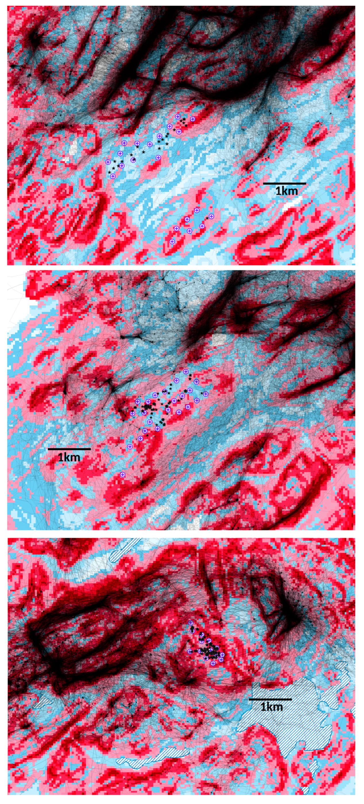
Our finding that territorial golden eagles in Scotland typically avoid wind turbines begs the question of whether this may affect their choice of nest sites or their occupation or re-occupation of formerly vacant territories which now include wind farms. Subjectively, there appears to be no discernible effect. For example, within the present study, nest sites were used or newly established which were 1.9 km and 1.5 km away when there were no closer alternatives nearer wind farms (A’Chruach and Cruach Mhor wind farms, respectively: Table 1, Figure 2). Re-occupation of vacant territories by tagged birds has occurred despite the proximity of wind farms (e.g., Beinn Ghlas: Table 1, Figure 2).
Anecdotally, despite a presumptive planning guideline for Scottish wind farms to be discouraged within the ‘core’ of a territory (i.e., within 3 km of nest sites: [73]), to our knowledge, nine pairs with at least one tagged partner have established nest sites or new territories involving nests located within 2 km of an operational wind farm. In the larger non-tagged population, there are further examples, though several will not have been documented, with the closest nest 125 m from the nearest turbine (R. Reid personal communication). Intriguingly, it appears that while Scottish territorial golden eagles are wary of most turbines and so avoid them, this does not necessarily transfer to their choice of nest sites as regards ‘disturbance distance’ or apparently ‘accepting’ them as (typically) largely unsuitable locations within their home range.
The present study re-affirms and expands on an apparent difference between the response to wind turbines by golden eagles in Scotland [39,40,56,57,58] and in the USA [7,14,15,18,19,28,49]. Previous speculation on this difference suggested that eagles could be more wary of turbines in Scotland because of greater historical and contemporary persecution by humans, rendering it beneficial to survival if any novel anthropogenic feature of the environment (such as wind turbines) is avoided [39,40]. There may also be planning differences if Scottish turbines are less often consented to in highly preferred eagle habitats, but this seems highly unlikely—at least in recent years (post-initial wind farm installations at Altamont in California) with increasing knowledge—given the enhanced protected status of the golden eagle in the USA (e.g., [14]).
Elsewhere in mainland Europe, there have been several studies highlighting the overlap between golden eagle distribution and potential wind farm development e.g., [54,55,104]. These studies typically emphasised the potential adverse impact of collision mortality, following from earlier USA findings. To our knowledge, however, we are unaware of any subsequent European study which has subsequently confirmed the collision mortality rates documented in the USA. The apparent absence of any empirical study of golden eagles at post-operational wind farms in mainland Europe, or any reporting of fatality rates (other than incidental records) in the peer-reviewed literature, is curious and may have several causes. It deserves further attention and outputs, especially when (for example), in some regions of Spain, monitoring of collision fatalities is mandatory [48].
In Scotland, golden eagle and wind farm development overlap in distribution was similarly prefaced [53] and has subsequently been reported on ([39,40], present study). In Scotland, the response to the coincidence of wind farm development and golden eagle distribution is primarily avoidance but does not exclude the possibility of collision in some circumstances. Records of collision fatalities are correspondingly rare (Introduction) despite a marked overlap between eagle distribution and substantial movements with wind farm distribution. However, it is important to caveat conclusions from studies such as [53] because the measure of what constituted suitable eagle habitat was a broad measure, but satellite tracking data show that quite fine-scale characteristics of the habitat are important in determining the movements of eagles; for example, see the flight lines in Figure 2.
In conclusion, while our results show that territorial eagles were like non-territorial eagles in substantively avoiding wind turbines, there were clearly common factors that may lead to greater prospects of collision, supporting those outlined previously [39,40]. The primary factor was if turbines were in highly preferred habitats surrounded by similarly highly preferred habitats.
In wind farm design planning, attempts to avoid such habitat would not only be beneficial by way of reducing prospective collision risk—even if fundamentally unlikely in Scotland—but would also reduce the functional habitat loss through avoidance. Such considerations based on habitat are not new at wider landscape scales (e.g., [31,32,33]) or at local installation scales [105], or specific turbine scales [101,102].
Our study emphasises the importance of wind farm design to include a focus on specific turbine locations and to identify prospective potential effects appropriately. In this respect, we recommend the involvement of the GET model for golden eagles and other facultative soaring large raptors (when it can be readily transferred: [72])—given a persistent finding of its predictions on habitat preference influence in informing proximity to turbine locations. For several large raptors, similar models to GET could provide an empirically based tool by which potential wind farm sites can be assessed and by which designs on specific turbine locations can be adjusted to avoid the potentially most problematic areas.
Whether via GET [72], other vulnerability modelling [19,101,102], or robust empirical assessment utilisation data, proposed specific turbine locations should be placed under special scrutiny in the planning process for large raptors, as they can differ in potential effect and impact (see also [50]). It is particularly important that proposed turbine locations with high habitat preference (and with similar surroundings), and the outer turbine locations, are evaluated as avoidance of these turbines on, for example, a ridge which could result in additional habitat losses outside of the wind farm.
A key and generic international takeaway from the present and earlier studies of Scottish golden eagles’ responses to turbines is that, if proposed turbines are in a highly preferred habitat, then regardless of the base response to turbines (on the avoidance—collision continuum), such locations should be problematic in wind farm planning. This is because, if consented, they will either disproportionately increase the risk of greater functional habitat loss or increase the risk of collision fatalities. The two outcomes differ in their effects, but each has detrimental impacts.

Author Contributions

Conceptulization, A.H.F. and D.P.W.; methodology, all authors; validation, A.H.F. and D.P.W.; formal analysis, A.H.F. and D.P.W.; investigation, all authors; data curation, A.H.F.; writing-original draft preparation, A.H.F. and D.P.W.; writing-review and editing, all authors; visualization, all authors; supervision, A.H.F. and D.P.W.; project administration, D.P.W.; funding acquisition, D.P.W., R.T., D.A., J.T. and S.B. All authors have read and agreed to the published version of the manuscript.

Funding

Funding of nestlings’ tags and data download costs notably came from Natural Research, the Royal Society for the Protection of Birds, SNH, Roy Dennis Wildlife Foundation, Ruth Tingay, and SSE. We are grateful to Thomas Plant and Emma Ahart (SSE) and Peter Robson (Scottish Power Renewables: SPR) for gaining permission to use data and to encourage tag funding of nestlings. Funding for the tagging of territorial birds came primarily from Natural Research (NR) with assistance from Forest Enterprise Scotland (FES: now Forestry and Land Scotland, FLS). Vattenfall generously provided funds for trapping and tagging of territorial birds whose range encompassed the Beinn Ghlas Wind Farm. Trapping of the territorial birds was led by David Anderson, with assistance from Ewan and Jenny Weston, and several FES staff, including Katy Anderson, Rebecca Smith, and Simon Smith. FES Wildlife Rangers were essential in sourcing and deploying carcasses at bait sites. Manuscript production was financially assisted by SSE under the Regional Eagle Conservation Management Plan research programme. For facilitating this assistance, we thank Emma Ahart, Thomas Plant, Jenny Chambers, and Nicki Small. Despite this support, SSE had no influence or commentary on manuscript production.

Institutional Review Board Statement

Not applicable.

Data Availability Statement

Within the limits of what can be circulated under protective legislation, raw data are in Table 1 and Table 2.

Acknowledgments

Tagging was undertaken by David Anderson, Roy Dennis, Brian Etheridge, Justin Grant, Duncan Orr-Ewing, and Ewan Weston: all were appropriately licensed under disturbance, handling, ringing, and tagging licenses from SNH (Scottish Natural Heritage: latterly NatureScot) and British Trust for Ornithology (BTO). We are extremely grateful for the considerable supporting fieldwork from many members of the Scottish Raptor Study Group. Staff at MTI (tag manufacture and support) and BTO (licensing) were helpful. We thank reviewers for their comments on an earlier draft which led to several improvements.

Conflicts of Interest

The authors declare no conflict of interest.

Appendix A

Does the GET model work for both territorial (range holding) and non-territorial (dispersing) birds?
The answer to the above question is yes.
The GET (Golden Eagle Topography) model was developed explicitly for dispersing non-territorial birds [72]. Below we test the robustness of the GET model when used with territorial range holding birds and with new data for dispersing non-territorial birds collected since the model was first developed. If the model performs well with these new data, it is an indication that it is a robust approach to modelling potential habitat use by golden eagles that could have greater utility in environmental impact assessments.
The robustness of the GET model was validated using tracking data collected later than the cut-off date used in development of the GET model (1 February 2017–31 December 2021). Training data for developing the GET model used data up to 1 January 2015 (146,116 records) while testing data (173,032 records) used data between 1 January 2015 and 15 January 2017. These tracking data are ‘new’ or involve validation data which played no part in the model’s development or original testing.
There were:
  • 1,711,876 records from 17 birds tagged as territorial range holding birds.
  • 349,521 records from 27 tags of birds that have settled on a territory after being tagged in the nest; some of which were sub-adult at settlement.
  • 4,555,637 records from 99 tags from non-territorial birds during dispersal.
The mean GET score was determined for all 10 km squares in Scotland and for a subset of squares which had satellite tracking records. Using its location, each tag record was assigned to a 10 km square and the GET score at its recorded location. Dividing the sum of tag GET scores by the number of tag records in a 10 km square gives the mean tag GET score for that 10 km square. It is normal for tag GET means to be larger than landscape GET means because golden eagles preferentially use those parts of a 10 km square with higher GET scores (Fielding et al., 2020). Figure A1 shows that golden eagles were more likely to be found in squares with higher mean GET scores. Note that the density tails off increasingly towards 10 because 10 km squares cannot have a mean GET of 10 unless the entire square is GET 10.
Figure A1. Density of mean GET landscape scores in 10 km OS squares. The black line is for 10 km squares with tag records (n = 755); the red line is the whole of Scotland (n = 1027). Vertical lines are the means (solid) and median (dashed) GET scores respectively.
Diversity 15 00917 g0a1
Figure A2 compares the GET densities of the landscape (black) against those for dispersing (red) and settled (blue) birds. Both tagged birds’ distributions have a marked right skew, i.e., tags selected parts of the 10 km squares with higher GET values. The skew was most pronounced for terriorial birds (blue). This skew was predominantly apparent after the previously documented switch point towards preference at GET 6 [72].
Figure A2. Frequency of the mean tag GET scores per 10 km square. The black line is the mean landscape GET score in squares with tag records. The red line is the frequency of tag mean GET scores in those squares for dispersing non-territorial birds. The blue line is the frequency of tag mean GET scores for range holding territorial birds. Vertical lines are the means (solid) and median (dashed) GET scores in the landscape.
Diversity 15 00917 g0a2
The density plots in Figure A1 and Figure A2 take no account of the number of tag records in a square which varied from 1 to 406,434 (square NN73: Ordnance Survey reference). The mean tag count per 10 km square is 8745 records (interquartile range 70 to 6200). Figure A3 shows the distribution of the log of the number of tag records per 10 km square.
Figure A3. Frequency of the log of the number of tag records per 10 km square.
Diversity 15 00917 g0a3
Bubble plots are scatter plots in which the size of the symbol is proportional to the number of observations (Figure A4). Figure A4 shows bubble plots for all non-territorial (dispersing) and territorial (range holding) birds’ mean GET scores, against the landscape mean GET score for 755 10 km squares with tag records.
The black diagonal lines in Figure A4 have a slope of 1 and an intercept of 0, i.e., the expected trend if the mean tag score is identical to the square’s mean landscape GET score, indicating no selection by the birds. The dotted red line also has slope of 1 but an intercept of 1, i.e., an offset of 1, so points above this line are for 10 km squares in which tag records have a mean GET score that is >1 more than the square’s mean landscape GET score.
Figure A4. Bubble scatter plots of the relationships between a 10 km square’s landscape mean GET score and the mean GET score of tag records in that square. The black diagonal line had a slope of 1 and an intercept of 0. The dashed red diagonal line had a slope of 1 and an intercept of 1.
Diversity 15 00917 g0a4
Figure A4 illustrates several points:
  • It is rare for the mean tag score to be less than the square’s landscape mean GET score, i.e., points below the black diagonal line. None of those squares has many records.
  • Non-territorial (dispersing) birds were rarely recorded in a 10 km square whose mean landscape GET score was <5.
  • Territorial (range holding) birds were very rarely recorded in a 10 km square whose mean landscape GET score was <6.
  • In most 10 km squares, even if the landscape men GET score was small, tags were recorded in parts of those squares with the higher GET scores, i.e., they were above the diagonal lines.
All three plots show the preference for higher GET scores, particularly in the range holding territorial birds.
Figure A5 shows the same data as Figure A4 but differences (mean tag GET score – mean landscape GET score) are plotted against the 10 km square mean landscape GET scores. Positive differences occur when birds are preferentially selecting the parts of the 10 km squares with higher GET scores. No selection is indicated by the black horizontal line where the difference is 0. Inevitably the differences get smaller as the mean landscape GET score increases because it is impossible to obtain large differences when the maximum GET value is constrained to be 10 or less.
Figure A5. Differences (mean tag GET score – mean landscape GET score) are plotted against the 10 km square mean landscape GET scores. The horizontal black line is a difference of 0 and the dashed red line is a difference of +1.
Diversity 15 00917 g0a5
Figure A6 shows the difference in GET scores with respect to the number of tag records. The largest negative differences are all in 10 km squares with only a small number of tag records. The trend, across all levels of the GET landscape, was for tags to have GET scores that were, on average, approximately one greater than the landscape in the square (Figure A6).
Figure A6. Differences in landscape and tag mean GET scores (10 km squares) with respect to the number of tag records in a square. The red line is LOESS smoothed, with grey 95% confidence limits.
Diversity 15 00917 g0a6
There is also a spatial element to the magnitude of negative differences (Figure A7). Ten km squares with negative differences (mean tag GET < mean landscape GET) tend to be on the periphery with small sample sizes.
There are two notable exceptions to the general trend, the first being at the head of Glen Coe. This 10 km square contains the Buachaille Etive Mor and the Glen Coe ski resorts and there will be increased human activity around these resorts, including at higher altitudes. The square has a mean GET score of 6.7 while the tag mean is a surprisingly low 6.0 from 4358 records.
The second example is between Loch Monar and Loch Mullardoch, with a mean landscape GET score of 7.9 and a tag GET mean of 7.4 (15,222 tag records). Despite being lower, the tag GET score in this square is still a reasonably large value.
Figure A7. Top left shows the number of tag records per 10 km square with darker reds being low counts and brighter greens larger counts. The other three plots show differences in 10 km square landscape mean GET scores and the tag mean GET scores. Darker greens are larger positive differences. Pink are negative differences. Dispersing tag data concerns non-territorial birds, and Range holding tag data concerns territorial birds. Contains Ordnance Survey data © Crown copyright and database right 2020.
Diversity 15 00917 g0a7

References

  1. Abbasi, T.; Premalatha, M.; Abbasi, S.A. Wind energy: Increasing deployment, rising environmental concerns. Renew. Sust. Energ. Rev. 2014, 31, 270–288. [Google Scholar] [CrossRef]
  2. GWEC. Global Wind Report. Annual Market Update; GWEC: Brussels, Belgium, 2015. [Google Scholar]
  3. RenewableUK. Wind Energy Statistics. 2023. Available online: https://www.renewableuk.com/page/UKWEDhome (accessed on 26 July 2023).
  4. Lu, X.; McElroy, M.B.; Kiviluoma, J. Global potential for wind-generated electricity. Proc. Natl. Acad. Sci. USA 2009, 106, 10933–10938. [Google Scholar] [CrossRef] [PubMed]
  5. Leung, D.Y.C.; Yang, Y. Wind energy development and its environmental impact: A review. Renew. Sust. Energ. Rev. 2012, 16, 1031–1039. [Google Scholar] [CrossRef]
  6. Saidur, R.; Rahim, N.A.; Islam, M.R.; Solangi, K.H. Environmental impact of wind energy. Renew. Sust. Energ. Rev. 2011, 15, 2423–2430. [Google Scholar] [CrossRef]
  7. Hunt, W.G. Golden Eagles in a Perilous Landscape: Predicting the Effects of Mitigation for Wind Turbine Blade-Strike Mortality; California Energy Commission: Sacramento, CA, USA, 2002; July 2002 Report No.: P500-02-043F. Available online: http://www.energy.ca.gov/reports/2002-11-04_500-02-043F.PDF (accessed on 10 October 2002).
  8. Hoover, S.L.; Morrison, M.L. Behavior of red-tailed hawks in a wind turbine development. J. Wildl. Manag. 2005, 69, 150–159. [Google Scholar] [CrossRef]
  9. Smallwood, K.S.; Thelander, C. Bird mortality in the Altamont Pass Wind Resource Area, California. J. Wildl. Manag. 2008, 72, 215–223. [Google Scholar] [CrossRef]
  10. Dahl, E.L.; Bevanger, K.; Nygård, T.; Røskaft, E.; Stokke, B.G. Reduced breeding success in white-tailed eagles at Smøla windfarm, western Norway, is caused by mortality and displacement. Biol. Conserv. 2012, 145, 79–85. [Google Scholar] [CrossRef]
  11. Hull, C.L.; Muir, S.C. Behavior and turbine avoidance rates of eagles at two wind farms in Tasmania, Australia. Wildl. Soc. Bull. 2013, 37, 49–58. [Google Scholar] [CrossRef]
  12. Smallwood, K.S. Comparing bird and bat fatality-rate estimates among North American wind-energy projects. Wildl. Soc. Bull. 2013, 37, 19–33. [Google Scholar] [CrossRef]
  13. Marques, A.T.; Batalha, H.; Rodrigues, S.; Costa, H.; Pereira, M.J.R.; Fonseca, C.; Mascarenhas, M.; Bernardino, J. Understanding bird collisions at wind farms: An updated review on the causes and possible mitigation strategies. Biol. Conserv. 2014, 179, 40–52. [Google Scholar] [CrossRef]
  14. Pagel, J.E.; Kritz, K.J.; Millsap, B.A.; Murphy, R.K.; Kershner, E.L.; Covington, S. Bald Eagle and Golden Eagle mortalities at wind energy facilities in the contiguous United States. J. Raptor Res. 2013, 47, 311–315. [Google Scholar] [CrossRef]
  15. Hunt, W.G.; Watson, J.W. Addressing the factors that juxtapose raptors and wind turbines. J. Raptor Res. 2016, 50, 92–96. [Google Scholar] [CrossRef]
  16. Hötker, H.; Krone, O.; Nehls, G. Birds of Prey and Wind Farms: Analysis of Problems and Possible Solutions; Springer: Cham, Switzerland, 2017. [Google Scholar]
  17. Hötker, H.; Dürr., T.; Grajetzky, B.; Grünkorn, T.; Joest, R.; Krone, O.; Mammen, K.; Mammen, U.; Nehls, G.; Rasran, L.; et al. Conclusions, risk assessment, conflict minimisation, practical recommendations, need for further study. In Birds of Prey and Wind Farms: Analysis of Problems and Possible Solutions; Hötker, H., Krone, O., Nehls, G., Eds.; Springer: Cham, Switzerland, 2017; pp. 323–331. [Google Scholar]
  18. Watson, R.T.; Kolar, P.S.; Ferrer, M.; Nygård, T.; Johnston, N.; Hunt, W.G.; Smit-Robinson, H.A.; Farmer, C.J.; Huso, M.; Katzner, T.E. Raptor interactions with wind energy: Case studies from around the world. J. Raptor Res. 2018, 52, 1–18. [Google Scholar] [CrossRef] [Green Version]
  19. Rolek, B.W.; Braham, M.A.; Miller, T.A.; Duerr, A.E.; Katzner, T.E.; McCabe, J.D.; Dunn, L.; McClure, C.J.W. Flight characteristics forecast entry by eagles into rotor-swept zones of wind turbines. Ibis 2022, 164, 968–980. [Google Scholar] [CrossRef]
  20. Penteriani, V.; Otalora, F.; Ferrer, M. Floater survival affects population persistence. The role of prey availability and environmental stochasticity. Oikos 2005, 108, 523–534. [Google Scholar] [CrossRef] [Green Version]
  21. Penteriani, V.; Otalora, F.; Sergio, F.; Ferrer, M. Environmental stochasticity in dispersal areas can explain the ‘mysterious’ disappearance of breeding populations. Proc. Roy. Soc. Lond. Ser. B 2005, 272, 1265–1269. [Google Scholar] [CrossRef]
  22. Penteriani, V.; Otalora, F.; Ferrer, M. Floater mortality within settlement areas can explain the Allee effect in breeding populations. Ecol. Model. 2008, 213, 98–104. [Google Scholar] [CrossRef]
  23. Ferrer, M.; Hiraldo, F. Evaluation of management techniques for the Spanish Imperial Eagle. Wildl. Soc. Bull. 1991, 19, 436–442. [Google Scholar]
  24. Real, J.; Mañosa, S. Demography and conservation of western European Bonelli’s eagle populations. Biol. Conserv. 1997, 79, 59–66. [Google Scholar] [CrossRef]
  25. USFWS. Bald and Golden Eagles: Population Demographics and Estimation of Sustainable Take in the United States, 2016 Update; U.S. Fish and Wildlife Service Division of Migratory Bird Management, 2016. Available online: http://www.fws.gov/migratorybirds/pdf/management/EagleRuleRevisions-StatusReport.pdf (accessed on 14 January 2019).
  26. Whitfield, D.P.; Fielding, A.H.; McLeod, D.R.A.; Haworth, P.F. Modelling the effects of persecution on the population dynamics of golden eagles in Scotland. Biol. Conserv. 2004, 119, 319–333. [Google Scholar] [CrossRef]
  27. Beston, J.A.; Diffendorfer, J.E.; Loss, S.R.; Johnson, D.H.; Moreira, F. Prioritizing avian species for their risk of population-level consequences from wind energy development. PLoS ONE 2016, 11, e0150813. [Google Scholar] [CrossRef] [PubMed] [Green Version]
  28. Hunt, W.G.; Wiens, J.D.; Law, P.R.; Fuller, M.R.; Hunt, T.L.; Driscoll, D.E.; Jackman, R.E. Quantifying the demographic cost of human-related mortality to a raptor population. PLoS ONE 2017, 12, e0172232. [Google Scholar]
  29. Carrete, M.; Sánchez-Zapata, J.A.; Benítez, J.R.; Lobón, M.; Donázar, J.A. Large scale risk-assessment of wind-farms on population viability of a globally endangered long-lived raptor. Biol. Conserv. 2009, 142, 2954–2961. [Google Scholar] [CrossRef] [Green Version]
  30. Bellebaum, J.; Korner-Nievergelt, F.; Dürr, T.; Mammen, U. Wind turbine fatalities approach a level of concern in a raptor population. J. Nat. Conserv. 2013, 21, 394–400. [Google Scholar] [CrossRef]
  31. Reid, T.; Krüger, S.; Whitfield, D.P.; Amar, A. Using spatial analysis of Bearded Vulture movement in southern Africa to inform wind turbine placement. J. Appl. Ecol. 2015, 52, 881–892. [Google Scholar] [CrossRef]
  32. Vasilakis, D.P.; Whitfield, D.P.; Schindler, S.; Poirazidis, K.S.; Kati, V. Reconciling endangered species conservation with wind farm development: Cinereous vultures (Aegypius monachus) in south-eastern Europe. Biol. Conserv. 2016, 196, 10–17. [Google Scholar] [CrossRef]
  33. Vasilakis, D.P.; Whitfield, D.P.; Kati, V. A balanced solution to the cumulative threat of industrialized wind farm development on cinereous vultures (Aegypius monachus) in south-eastern Europe. PLoS ONE 2017, 12, e0172685. [Google Scholar] [CrossRef] [Green Version]
  34. May, R.F. A unifying framework for the underlying mechanisms of avian avoidance of wind farms. Biol. Conserv. 2015, 190, 179–187. [Google Scholar] [CrossRef]
  35. Madders, M.; Whitfield, D.P. Upland raptors and the assessment of wind farm impacts. Ibis 2006, 148 (Suppl. S1), 43–56. [Google Scholar] [CrossRef]
  36. Dahl, E.L.; May, R.L.; Hoel, P.L.; Bevanger, K.; Pedersen, H.C.; Røskaft, E.; Stokke, B.G. White-tailed Eagles (Haliaeetus albicilla) at the Smøla wind power plant, central Norway, lack behavioral flight responses to wind turbines. Wildl. Soc. Bull. 2013, 37, 66–74. [Google Scholar] [CrossRef]
  37. Marques, A.T.; Santos, C.D.; Hanssen, F.; Muñoz, A.-R.; Onrubia, A.; Wikelski, M.; Moreira, F.; Palmeirim, J.M.; Silva, J.P. Wind turbines cause functional habitat loss for migratory soaring birds. J. Anim. Ecol. 2020, 89, 93–103. [Google Scholar] [CrossRef] [PubMed] [Green Version]
  38. Santos, C.D.; Marques, A.T.; May, R. Recovery of raptors from displacement by wind farms—A response. Front. Ecol. Environ. 2020, 18, 121–122. [Google Scholar] [CrossRef]
  39. Fielding, A.H.; Anderson, D.; Benn, S.; Dennis, R.; Geary, M.; Weston, E.; Whitfield, D.P. Non-territorial GPS-tagged golden eagles Aquila chrysaetos at two Scottish wind farms: Avoidance influenced by preferred habitat distribution, wind speed and blade motion status. PLoS ONE 2021, 16, e0254159. [Google Scholar] [CrossRef] [PubMed]
  40. Fielding, A.H.; Anderson, D.; Benn, S.; Dennis, R.; Geary, M.; Weston, E.; Whitfield, D.P. Responses of dispersing GPS-tagged Golden Eagles Aquila chrysaetos to multiple wind farms across Scotland. Ibis 2022, 164, 102–117. [Google Scholar] [CrossRef]
  41. Garvin, J.C.; Jennelle, C.S.; Drake, D.; Grodsky, S.M. Response of raptors to a windfarm. J. Appl. Ecol. 2011, 48, 199–209. [Google Scholar] [CrossRef]
  42. Johnston, N.N.; Bradley, J.E.; Otter, K.A. Increased flight altitudes among migrating golden eagles suggest turbine avoidance at a Rocky Mountain wind installation. PLoS ONE 2014, 9, e93030. [Google Scholar] [CrossRef] [Green Version]
  43. Villegas-Patraca, R.; Cabrera-Cruz, S.A.; Herrera-Alsina, L. Soaring migratory birds avoid wind farm in the Isthmus of Tehuantepec, Southern Mexico. PLoS ONE 2014, 9, e92462. [Google Scholar] [CrossRef] [PubMed]
  44. Dohm, R.; Jennelle, C.S.; Garvin, J.C.; Drake, D. A long-term assessment of raptor displacement at a wind farm. Front. Ecol. Environ. 2019, 17, 433–438. [Google Scholar] [CrossRef]
  45. Whitfield, D.P.; McLeod, D.R.A.; Fielding, A.H.; Broad, R.A.; Evans, R.J.; Haworth, P.F. The effects of forestry on golden eagles on the island of Mull, western Scotland. J. Appl. Ecol. 2001, 38, 1208–1220. [Google Scholar] [CrossRef]
  46. Whitfield, D.P.; Fielding, A.H.; Gregory, M.J.P.; Gordon, A.G.; McLeod, D.R.A.; Haworth, P.F. Complex effects of habitat loss on golden eagles Aquila chrysaetos. Ibis 2007, 149, 26–36. [Google Scholar] [CrossRef]
  47. Newton, I. Population Ecology of Raptors; Poyser: Berkhamstead, UK, 1979. [Google Scholar]
  48. Ferrer, M.; de Lucas, M.; Janss, G.F.E.; Casado, E.; Muñoz, A.R.; Bechard, M.J.; Calabuig, C.P. Weak relationship between risk assessment studies and recorded mortality in wind farms. J. Appl. Ecol. 2012, 49, 38–46. [Google Scholar] [CrossRef] [Green Version]
  49. Watson, J.W.; Duff, A.A.; Davies, R.W. Home range and resource selection by GPS-monitored adult Golden Eagles in the Columbia plateau ecoregion: Implications for wind power development. J. Wildl. Manage. 2014, 78, 1012–1021. [Google Scholar] [CrossRef]
  50. McClure, C.J.W.; Rolek, B.W.; Dunn, L.; McCabe, J.; Martinson, L.; Katzner, T. Eagle fatalities are reduced by automated curtailment of wind turbines. J. Appl. Ecol. 2021, 58, 446–452. [Google Scholar] [CrossRef]
  51. Katzner, T.E.; Brandes, D.; Miller, T.; Lanzone, M.; Maisonneuve, C.; Tremblay, J.A.; Mulvihill, R.; Merovich, G.T. Topography drives migratory flight altitude of golden eagles: Implications for on-shore wind energy development. J. Appl. Ecol. 2012, 49, 1178–1186. [Google Scholar] [CrossRef]
  52. Katzner, T.E.; Turk, P.J.; Duerr, A.E.; Miller, T.A.; Lanzone, M.J.; Cooper, J.L.; Brandes, D.; Tremblay, J.A.; Lemâıtre, J. Use of multiple modes of flight subsidy by a soaring terrestrial bird, the golden eagle Aquila chrysaetos, when on migration. J. Roy. Soc. Interface 2015, 12, 20150530. [Google Scholar] [CrossRef] [PubMed] [Green Version]
  53. Fielding, A.H.; Whitfield, D.P.; McLeod, D.R.A. Spatial association as an indicator of the potential for future interactions between wind energy developments and golden eagles Aquila chrysaetos in Scotland. Biol. Conserv. 2006, 131, 359–369. [Google Scholar] [CrossRef]
  54. Tapia, L.; Domínguez, J.; Rodríguez, L. Using probability of occurrence to assess potential interaction between wind farms and a residual population of golden eagle Aquila chrysaetos in NW Spain. Biodivers. Conserv. 2009, 18, 2033–2041. [Google Scholar] [CrossRef]
  55. Martínez, J.E.; Calvo, J.F.; Martínez, J.A.; Zuberogoitia, I.; Cerezo, E.; Manrique, J.; Gómez, G.J.; Nevado, J.C.; Sánchez, M.; Sánchez, R.; et al. Potential impact of wind farms on territories of large eagles in southeastern Spain. Biodivers. Conserv. 2010, 19, 3757–3767. [Google Scholar] [CrossRef]
  56. Walker, D.; McGrady, M.; McCluskie, A.; Madders, M.; McLeod, D.R.A. Resident golden eagle ranging behaviour before and after construction of a windfarm in Argyll. Scot. Birds 2005, 25, 24–40. [Google Scholar]
  57. Haworth Conservation. Edinbane Windfarm: Ornithological Monitoring. A Review of the Spatial Use of the Area by Birds of Prey; Haworth Conservation: Isle of Mull, Scotland, 2012. [Google Scholar]
  58. Whitfield, D.P.; Fielding, A.H. Analyses of the Fates of Satellite Tracked Golden Eagles in Scotland; SNH Commissioned Report No. 982; SNH: Battleby, Scotland, 2017. [Google Scholar]
  59. Watson, J.W.; Keren, I.N.; Davies, R.W. Behavioral accommodation of nesting hawks to wind turbines. J. Wildl. Manag. 2018, 82, 1784–1793. [Google Scholar] [CrossRef]
  60. Troen, I.; Petersen, E.L. European Wind Atlas; EU Commission DGXII; Risø National Laboratory: Copenhagen, Denmark, 1998. [Google Scholar]
  61. Scottish Government. Renewables Policy. 2016. Available online: https://www2.gov.scot/Topics/Business-Industry/Energy/Energy-sources/19185/17612 (accessed on 15 May 2017).
  62. Scottish Government. Onshore Wind: Policy Statement. 2017. Available online: https://www.gov.scot/publications/onshore-wind-policy-statement-9781788515283/ (accessed on 12 July 2023).
  63. Scottish Renewables. 2020. Available online: https://www.scottishrenewables.com/our-industry/statistics (accessed on 23 April 2020).
  64. European Commission. Directive 2009/147/EC of the European Parliament and of the Council of 30 November 2009 on the Conservation of Wild Birds (Document 32001L0042). 2009. Available online: http://eur-lex.europa.eu/legal-content/EN/TXT/?uri=CELEX:32009L0147&qid=1450371195423 (accessed on 15 December 2015).
  65. Scottish Natural Heritage. Guidance. Recommended Bird Survey Methods to Inform Impact Assessment of Onshore Wind Farms; SNH: Battleby, Scotland, 2014. [Google Scholar]
  66. Hayhow, D.B.; Benn, S.; Stevenson, A.; Stirling-Aird, P.K.; Eaton, M.A. Status of Golden Eagle Aquila chrysaetos in Britain in 2015. Bird Study 2017, 64, 281–294. [Google Scholar] [CrossRef]
  67. Watson, J. The Golden Eagle, 2nd ed.; Poyser: London, UK, 2010. [Google Scholar]
  68. Whitfield, D.P.; Fielding, A.H.; McLeod, D.R.A.; Haworth, P.F. The effects of persecution on age of breeding and territory occupation in golden eagles in Scotland. Biol. Conserv. 2004, 118, 249–259. [Google Scholar] [CrossRef]
  69. Whitfield, D.P.; Fielding, A.H.; McLeod, D.R.A.; Morton, K.; Stirling-Aird, P.; Eaton, M. Factors constraining the distribution of Golden Eagles Aquila chrysaetos in Scotland. Bird Study 2007, 54, 199–211. [Google Scholar] [CrossRef]
  70. Whitfield, D.P.; Fielding, A.H.; McLeod, D.R.A.; Haworth, P.F. A Conservation Framework for Golden Eagles: Implications for Their Conservation and Management in Scotland; Scottish Natural Heritage Commissioned Report No.193; SNH: Battleby, Scotland, 2008. [Google Scholar]
  71. Fielding, A.H.; Anderson, D.; Benn, S.; Reid, R.; Tingay, R.; Weston, E.D.; Whitfield, D.P. Substantial variation in prospecting behaviour of Golden Eagles Aquila chrysaetos defies expectations from potential predictors. Diversity 2023, 15, 506. [Google Scholar] [CrossRef]
  72. Fielding, A.H.; Haworth, P.; Anderson, D.; Benn, S.; Dennis, R.; Weston, E.; Whitfield, D.P. A simple topographical model to predict Golden Eagle Aquila chrysaetos space use during dispersal. Ibis 2020, 162, 400–415. [Google Scholar] [CrossRef] [Green Version]
  73. Whitfield, D.P.; Fielding, A.H. The Use of PAT and GET Models in Assessment of Proposals Affecting Territorial Golden Eagles: Advice to Inform Interim Guidance; A report from Natural Research Ltd to Scottish Natural Heritage; Natural Research Ltd.: Banchory, Scotland, 2020. [Google Scholar]
  74. Weston, E.D.; Whitfield, D.P.; Travis, J.M.J.; Lambin, X. When do young birds disperse? Tests from studies of golden eagles in Scotland. BMC Ecology 2013, 13, 1–13. [Google Scholar] [CrossRef] [Green Version]
  75. Weston, E.D.; Whitfield, D.P.; Travis, J.M.J.; Lambin, X. The contribution of flight capability to the post-fledging dependence period of golden eagles. J. Avian Biol. 2018, 49, e01265. [Google Scholar] [CrossRef]
  76. Byrne, M.E.; Holland, A.E.; Bryan, A.L.; Beasley, J.C. Environmental conditions and animal behavior influence performance of solar-powered GPS-GSM transmitters. Condor 2017, 119, 389–404. [Google Scholar] [CrossRef] [Green Version]
  77. Whitfield, D.P.; Fielding, A.H.; Anderson, D.; Benn, S.; Dennis, R.; Grant, J.; Weston, E.D. Age of first territory settlement of Golden Eagles Aquila chrysaetos in a variable competitive landscape. Front. Ecol. Evol. 2022, 10, 743598. [Google Scholar] [CrossRef]
  78. Whitfield, D.P.; Fielding, A.H.; Anderson, D.; Benn, S.; Reid, R.; Tingay, R.; Weston, E. Sex difference in natal dispersal distances of Golden Eagles Aquila chrysaetos in Scotland. Ibis 2023. [Google Scholar] [CrossRef]
  79. Reid, R.; Haworth, P.F.; Fielding, A.H.; Whitfield, D.P. Spatial distribution of undulating flight displays of territorial Golden Eagles Aquila chrysaetos in Lewis, Scotland. Bird Study 2019, 66, 407–412. [Google Scholar] [CrossRef]
  80. Bloom, P.H.; Clark, W.S. Molt and sequence of plumages of Golden Eagles and a technique for in-hand ageing. N. Am. Bird Bander 2001, 26, 97–116. [Google Scholar]
  81. Harmata, A.; Montopoli, G. Morphometric determination of North American Golden Eagles. J. Raptor Res. 2013, 47, 108–116. [Google Scholar] [CrossRef] [Green Version]
  82. Hoechlin, D.R. Development of golden eaglets in southern California. West. Birds 1976, 7, 137–152. [Google Scholar]
  83. Peterson, D. Möt Kungsörnen; ICA Bokförlag: Västerås, Sweden, 1997. [Google Scholar]
  84. Davies, M.; Green, R. A classification of methods used to attach devices to vultures and condors. Vulture News 2020, 78, 12–17. [Google Scholar] [CrossRef]
  85. Orr-Ewing, D.; Anderson, D.; Weston, E. Thoracic X-Strap Harness. Design and Method 2. Vulture News 2020, 78, 27–30. [Google Scholar] [CrossRef]
  86. Thaxter, C.B.; Ross-Smith, V.H.; Clark, J.A.; Clark, N.A.; Conway, G.J.; Masden, E.; Wade, H.M.; Leat, E.H.K.; Gear, S.C.; Marsh, M.; et al. Contrasting effects of GPS device and harness attachment on adult survival of Lesser Black-backed Gulls Larus fuscus and Great Skuas Stercorarius skua. Ibis 2016, 158, 279–290. [Google Scholar] [CrossRef]
  87. García, V.; Iglesias-Lebrija, J.J.; Moreno-Opo, R. Null effects of Garcelon harnessing method and transmitter type on soaring raptors. Ibis 2021, 163, 899–912. [Google Scholar] [CrossRef]
  88. Anderson, D.; Arkumarev, V.; Bildstein, K.; Botha, A.; Bowden, C.G.R.; Davies, M.; Duriez, O.; Forbes, N.A.; Godino, A.; Green, R.E.; et al. A practical guide to methods for attaching research devices to vultures and condors. Vulture News 2020, 78, 1–72. [Google Scholar]
  89. Phillips, R.A.; Xavier, J.C.; Croxall, J.P. Effects of satellite transmitters on albatrosses and petrels. Auk 2003, 120, 1082–1090. [Google Scholar] [CrossRef]
  90. Kenward, R.E. A Manual for Wildlife Radio Tagging; Academic Press: London, UK, 2001. [Google Scholar]
  91. Sergio, F.; Tavecchia, G.; Tanferna, A.; López Jiménez, L.; Blas, J.; De Stephanis, R.; Marchant, T.A.; Kumar, N.; Hiraldo, F. No effect of satellite tagging on survival, recruitment, longevity, productivity and social dominance of a raptor, and the provisioning and condition of its offspring. J. Appl. Ecol. 2015, 52, 1665–1675. [Google Scholar] [CrossRef]
  92. QGIS.org. QGIS Geographic Information System. QGIS Association. 2023. Available online: http://www.qgis.org (accessed on 15 July 2023).
  93. Zuur, A.; Ieno, E.N.; Smith, G.M. Analyzing Ecological Data; Springer: New York, NY, USA, 2007. [Google Scholar]
  94. Zuur, A.F.; Hilbe, J.; Ieno, E.N.; Zuur, A.F.; Hilbe, J.M.; Leno, E.N. A Beginner’s Guide to GLM and GLMM with R: A Frequentist and Bayesian Perspective for Ecologists; Highland Statistics Ltd.: Newburgh, Scotland, 2013. [Google Scholar]
  95. R Core Team. R: A language and environment for statistical computing; R Foundation for Statistical Computing: Vienna, Austria, 2023; Available online: https://www.R-project.org/ (accessed on 15 July 2023).
  96. Posit team. RStudio: Integrated Development Environment for R; Posit Software PBC: Boston, MA, USA, 2023; Available online: http://www.posit.co/ (accessed on 15 July 2023).
  97. Bates, D.; Mächler, M.; Bolker, B.; Walker, S. Fitting Linear Mixed-Effects Models Using lme4. J. Stat. Softw. 2015, 67, 1–48. [Google Scholar] [CrossRef]
  98. Schielzeth, H.; Forstmeier, W. Conclusions beyond support: Overconfident estimates in mixed models. Behav. Ecol. 2009, 20, 416–420. [Google Scholar] [CrossRef]
  99. Burnham, K.; Anderson, D. Model Selection and Multi-model Inference, 2nd ed.; Springer: New York, NY, USA, 2002. [Google Scholar]
  100. Fabozzi, F.J.; Focardi, S.M.; Rachev, S.T.; Arshanapalli, B.G. The Basics of Financial Econometrics: Tools, Concepts, and Asset Management Applications; Appendix E. Model Selection Criteria: AIC and BIC; John Wiley & Sons: New York, NY, USA, 2014. [Google Scholar]
  101. de Lucas, M.; Ferrer, M.; Bechard, M.J.; Muñoz, A.R. Griffon vulture mortality at wind farms in southern Spain: Distribution of fatalities and active mitigation measures. Biol. Conserv. 2012, 147, 184–189. [Google Scholar] [CrossRef] [Green Version]
  102. de Lucas, M.; Ferrer, M.; Janss, G.F.E. Using wind tunnels to predict bird mortality in wind farms: The case of Griffon Vultures. PLoS ONE 2012, 7, e48092. [Google Scholar] [CrossRef] [Green Version]
  103. Dohm, R.; Jennelle, C.S.; Garvin, J.C.; Drake, D. Documented raptor displacement at a wind farm. Front. Ecol. Environ. 2020, 18, 122–123. [Google Scholar] [CrossRef]
  104. Singh, N.J.; Moss, E.; Hipkiss, T.; Ecke, F.; Dettki, H.; Sandström, P.; Bloom, P.; Kidd, J.; Thomas, S.; Hörnfeldt, B. Habitat selection by adult golden eagles Aquila chrysaetos during the breeding season and implications for wind farm establishment. Bird Study 2016, 63, 233–240. [Google Scholar] [CrossRef]
  105. Johnson, G.D.; Strickland, M.D.; Erickson, W.P.; Young, D.P., Jr. Use of data to develop mitigation measures for wind power development impacts to birds. In Birds and Wind Farms: Risk Assessment and Mitigation; de Lucas, M., Janss, G.F.E., Ferrer, M., Eds.; Quercus: Madrid, Spain, 2007; pp. 241–257. [Google Scholar]
Figure 1. Locations of the 11 study wind farms. 1 A’ Chruach; 2 Allt Dearg; 3 An Suidhe; 4 Beinn an Tuirc; 5 Beinn an Tuirc 2; 6 Beinn an Tuirc 3; 7 Beinn Ghlas; 8 Blary Hill; 9 Carraig Ghael; 10 Cruach Mhor; 11 Stronelairg (see also Table 1). The backdrop shows outputs at a 50 m pixel scale from the Golden Eagle Topography (GET) model, as a robust proxy of golden eagle habitat preference, keyed to 1–10 values, with 6+ values indicating the switch point towards increasing preference (see main text).
Diversity 15 00917 g001
Figure 2. Examples of GPS records of territorial birds at three study wind farms (turbine locations as blue crosses). Upper panel A’Chruach, middle panel An Suidhe, lower panel Beinn Ghlas (see Figure 1 for wider geography and Table 1 for geographic coordinates). Delineated areas with diagonal blue lines show large freshwater bodies (lochs). The backdrop from white to pale blue through pink to increasing intensity of red illustrates GET model values (0–10), with the switch to red (and increasing intensity of red) reflecting predicted preferred habitat (6+) with increasing preference intensity. Records of eagles within the wind farm (3D) are shown with black stars. Black lines show connections between consecutive territorial birds’ records (<1 km as a cut-off, illustratively) for birds whose territorial boundaries enveloped the respective wind farms. See main text and Table 3 for disparity of record numbers within and out with the study’s wind farms.
Diversity 15 00917 g002
Table 1. Wind farm characteristics. MW is the notional power output of all turbines; Diameter is the diameter of the blades (m); Hub Ht is the height of the hub above ground level (m); mean GET ([72]; and see later text) is the mean Golden Eagle Topography model (GET) score (averaged over 100 m) for turbines in the wind farm, and Operational is the date the wind farm became operational. Locations of the central point of the wind farms are given by Ordnance Survey coordinates (OS_X, OS_Y) and latitude and longitude (see also Figure 1).
Wind FarmTurbinesMWDiameterHub HtMean GETOperationalOS_XOS_YLatLong
A’Chruach2148.390805.629 June 2016192809697756−5.33456.128
Allt Dearg1210.852557.425 Sept 2012182397676545−5.48455.933
An Suidhe2319.34856604 Aug 2010200860708210−5.21356.225
Beinn an Tuirc463071655.423 Dec 2001174373636250−5.57955.568
Beinn an Tuirc Phase 21643.782596.501 Sept 2014175350630739−5.55955.519
Beinn an Tuirc Phase 31450112705.528 Oct 2021173561633440−5.59055.542
Beinn Ghlas147.844357.625 June 1999197855725785−5.27456.381
Blary Hill1428101935.601 Jan 2020171379636571−5.62755.569
Carraig Gheal204693655.931 Aug 2013197244720675−5.28056.335
Cruach Mhor3533.352455.431 Jan 2004203712687583−5.15156.041
Stronelairg66228115735.911 Dec 2018252205803549−4.44057.099
Table 2. Tagged bird data. ID (bold is a dispersing non-territorial bird that later settled); First and Last are the first and last record dates. For birds tagged in the nest, dates are given for dispersal and settlement (if has happened yet); Status is the tag’s status at the last record date (SNMF—stopped no malfunction fate, an assumed illegal killing); Records (locations within 1 km of a turbine); All is the total number of tag records whilst the bird was territorial or dispersing.
IDSEXFirstLastDispersedSettledStatusRecordsAll
Territorial birds
102F30 Nov 201504 July 2021 SNMF376088,398
816M01 Mar 201706 Nov 2022 Still tracking28,618442,963
991M09 Feb 201809 Nov 2021 Still tracking24,712496,576
992F25 Jan 201913 Feb 2020 Died—natural43910,409
925F27 June 201729 Oct 202227 Feb 201826 Sept 2022Still tracking3463258,127
996M20 Feb 202102 Dec 2021 SNMF14,65099,379
1025M26 June 201814 Sept 202220 Jan 201910 Sept 2021Still tracking502398,978
1031M02 July 201830 Oct 202201 Apr 201906 Sept 2021Still tracking152173,301
1157F07 Feb 202103 Mar 2023 Still tracking4921239,532
Non-territorial birds
100M22 June 201408 Nov 202204 Feb 201522 Mar 2019Still tracking69345,618
582F07 July 201608 Nov 202207 Nov 201602 Mar 2021Still tracking84831,955
584M03 July 201508 Nov 202212 Apr 201616 Oct 2021Still tracking1415130,405
810F29 June 201620 Jan 202008 Mar 2017 Stopped—malfunction223103,953
811F29 June 201608 Nov 202216 Jan 2017 Still tracking890253,944
812M29 June 201608 Nov 202212 Dec 2016 Still tracking50,608383,400
925F27 June 201729 Oct 202227 Feb 201826 Sept 2022Still tracking6518246,110
930M04 July 201728 Oct 202215 Mar 2018 Still tracking5703311,021
933F07 June 201929 Oct 202219 Sept 201920 Apr 2022Still tracking568275,210
997F28 Feb 202102 Mar 202328 Feb 202120 Oct 2022Died—natural47885,073
1023F15 June 201809 May 202103 Jan 2019 SNMF2796201,250
1025M26 June 201814 Sept 202220 Jan 201910 Sept 2021Still tracking55,047348,593
1030F07 July 201824 Oct 202128 Oct 201819 Apr 2021Still tracking1522139,709
1031M02 July 201830 Oct 202201 Apr 201906 Sept 2021Still tracking995191,410
1075M04 July 201929 July 202023 Oct 2019 Stopped—malfunction23960,266
1078F20 June 202008 Nov 202225 Jan 2021 Stopped—malfunction574193,416
1092M27 June 201929 Oct 202201 Nov 2019 Still tracking7645169,591
1093M06 July 202129 Oct 202205 Nov 2021 Still tracking12371,099
1096F04 July 201929 Oct 202230 Oct 2019 SNMF80242,738
1099F01 July 202029 Oct 202213 Feb 2021 Still tracking1737161,798
10220M24 June 201810 Sept 201919 Feb 2019 Died—natural141376,812
57106F16 July 201026 June 201413 Nov 2010 Stopped—malfunction33810,200
107140F25 June 201224 June 201721 Jan 2013 Stopped—malfunction999875
129005M01 July 201301 Mar 202306 Nov 201326 Jan 2016Still tracking2093291
129007 21 June 201512 Dec 201625 Feb 2016 Died—natural541434
129015F27 June 201411 June 201614 Nov 2014 SNMF732904
148633F26 June 201501 Mar 202309 Feb 2016 Still tracking629393
Table 3. Descriptive statistics for distances (m) from bird records to the nearest turbine hub. q0.025 and q0.975 show 2.5% and 97.5% quantiles. Number of records is given by n, and class differentiates between intruding non-territorial birds (NT) and territorial range holders (T).
Wind FarmMeanminsdq0.025q0.975nClass
A’Chruach71911726824611622183NT
7347519032499824,915T
Allt Dearg659882322441050947NT
6712042382551041128T
An Suidhe641612541799977485NT
6204826515498928,835T
Beinn an Tuirc63628111415985453NT
63383284150115160T
Beinn an Tuirc 2689632342041010549NT
7767321828110031337T
Beinn an Tuirc 3645532811709911028NT
527882601609731859T
Beinn Ghlas75513119830410021365NT
6032627610099618,985T
Blary Hill36852244158923542NT
44018820523689253T
Carraig Ghael76210324326410001014NT
7531282211871002593T
Cruach Mhor804392182531168864NT
6886226917210863796T
Stronelairg55949234173968124,494NT
693104261180999502T
Table 4. Descriptive statistics for Golden Eagle Topography (GET) model values from across all study wind farms according to several metrics. In a potential range of 0–10 values, the switch point indicating increasing preference is 6+ (Methods). Differentiation between inside and outside of wind farms is described in Methods.
GET Values
MetricMeansdRange
Turbine locations5.91.353.0–9.2
Random points: inside5.71.213.0–9.8
Random points: outside6.31.640.3–10.0
Non-territorial birds: inside6.31.263.0–9.8
Non-territorial birds: outside7.91.640.6–10.0
Territorial birds: inside6.31.253.0–9.1
Territorial birds: outside7.41.380.3–10.0
Table 5. Summary outputs of the four analytical models (see Methods). m0 was the null model, containing only random effects; m1 included the fixed effect of ‘class’ (birds’ class as territorial or non-territorial); m2 included the fixed effect of GET model (surrogate for habitat preference), and m3 included both ‘class’ and ‘GET’ as fixed effects. Intercept column shows model coefficients with 95% CLs in parentheses.
ModelAICInterceptClassGETMarginal R2/Conditional R2
m03063751538.3 (455.7–620.8) 0.000/0.378
m13063751535.7 (453.1–618.4)6.4 (−4.6–17.4) 0.000/0.377
m23056509505.1 (420.2–589.9) 24.2 (−5.4–53.7)0.019/0.430
m33056509508.5 (423.9–593.0)−8.9 (−19.8–2.1)24.2 (−5.6–54.0)0.019/0.433
Table 6. Model comparisons (see Table 5 for model structures and terminology on fixed effects). npar is the number of parameters.
ModelFixed EffectsnparAICLog-LikelihoodDevianceΧ2dfp (>Χ2)
m0none43063751−15318713063743
comparing with m0 (null model)
m1class53063751−153187130637411.29510.2551
m2GET93056509−152824630564917251.65<0.0001
m3class and GET103056509−152824430564897254.16<0.0001
comparing with m1 (class model)
m3class and GET103056509−152824430564897252.85<0.0001
comparing with m2 (GET model)
m3class and GET103056509−152824430564892.519710.1124
Disclaimer/Publisher’s Note: The statements, opinions and data contained in all publications are solely those of the individual author(s) and contributor(s) and not of MDPI and/or the editor(s). MDPI and/or the editor(s) disclaim responsibility for any injury to people or property resulting from any ideas, methods, instructions or products referred to in the content.

