
The Large-Scale Investigation and Analysis of Lophodermium piceae in Subalpine Areas Based on Satellite Multi-Spectral Remote Sensing

Abstract
:
1. Introduction
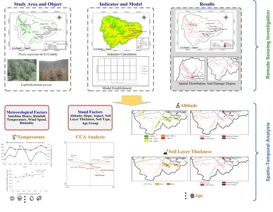
2. Methods
2.1. Study Areas
2.2. Characteristics of Lophodermium piceae
2.3. Data Sources
2.3.1. Satellite-Borne Multi-Spectral Remote Sensing Images
2.3.2. Forest Resources Data
2.3.3. Ground Survey Data of Lophodermium piceae
2.3.4. Other Relevant Data
2.4. Remote Sensing Investigation Indicator of Lophodermium piceae
2.5. Establishment of Remote Sensing Investigation Model
2.6. Spatio-Temporal Analysis Methods for Lophodermium piceae
2.6.1. Temporal Analysis Methods
2.6.2. Spatial Analysis Methods
3. Results
3.1. Remote Sensing Investigation Results of Lophodermium piceae
3.2. Temporal Analysis Results about Climate Variables
3.3. Spatial Analysis Results about Other Environmental Impact Factors
4. Discussion
Author Contributions
Funding
Institutional Review Board Statement
Data Availability Statement
Acknowledgments
Conflicts of Interest
Appendix A

| Site Number | Longitude | Latitude | Damage Degree |
|---|---|---|---|
| 1 | 102.71 | 31.86 | Light |
| 2 | 102.68 | 31.78 | Light |
| 3 | 102.88 | 31.53 | Normal |
| 4 | 102.79 | 31.29 | Light |
| 5 | 102.96 | 31.33 | Serious |
| 6 | 102.90 | 31.40 | Serious |
| 7 | 103.22 | 31.54 | Moderate |
| 8 | 103.03 | 31.73 | Normal |
| 9 | 103.18 | 31.62 | Normal |
| Years | 2009 | 2010 | 2011 | 2012 | 2013 | 2014 | 2015 | 2016 | 2017 |
|---|---|---|---|---|---|---|---|---|---|
| Total Damage Areas | 520.26 | 1000.5 | 867.1 | 867.1 | 867.1 | 807.07 | 940.47 | 1113.89 | 973.82 |
References
- Pan, H. Problems and Countermeasures in Forest Pest Prevention in China. J. For. Pest Dis. 2002, 21, 42–47. [Google Scholar]
- Bai, X.; Zhang, X.; Zhang, N.; Zhang, L.; Ma, Y. Monitoring Model of Dendrolimus tabulaeformis Disaster Using Hyperspectral Remote Sensing Technology. J. Beijing For. Univ. 2016, 13, 16–22. [Google Scholar] [CrossRef]
- Wang, L.; Luo, Y.; Huang, H.; Shi, J.; Keliovaara, K.; Teng, W. Reflectance Features of Water Stressed Larix gmelinii Needles. For. Stud. China 2009, 11, 28–33. [Google Scholar] [CrossRef]
- Xu, Z.; Li, C.; Liu, J.; Yu, K.; Gong, C.; Tang, M. Fisher Discriminant Analysis of Dendrolimus Punctatus Walker Pest Levels. Nongye Jixie Xuebao Trans. Chin. Soc. Agric. Mach. 2014, 45, 275–283. [Google Scholar] [CrossRef]
- Ghavidel, M.; Bayat, P.; Farashiani, M.E. Satellite Image Processing of the Buxus hyrcana Pojark Dieback in the Northern Forests of Iran. J. For. Sci. 2021, 67, 71–79. [Google Scholar] [CrossRef]
- Bhattarai, R.; Rahimzadeh-Bajgiran, P.; Weiskittel, A.; Meneghini, A.; MacLean, D.A. Spruce Budworm Tree Host Species Distribution and Abundance Mapping Using Multi-Temporal Sentinel-1 and Sentinel-2 Satellite Imagery. ISPRS J. Photogramm. Remote Sens. 2020, 172, 28–40. [Google Scholar] [CrossRef]
- Ye, H.; Huang, W.; Huang, S.; Cui, B.; Dong, Y.; Guo, A.; Ren, Y.; Jin, Y. Recognition of Banana Fusarium Wilt Based on UAV Remote Sensing. Remote Sens. 2020, 12, 938. [Google Scholar] [CrossRef]
- Greene, A.D.; Reay-Jones, F.P.; Kirk, K.R.; Peoples, B.K.; Greene, J.K. Spatial Associations of Key Lepidopteran Pests with Defoliation, NDVI, and Plant Height in Soybean. Environ. Entomol. 2021, 50, 1378–1392. [Google Scholar] [CrossRef]
- Oblinger, B.W.; Bright, B.C.; Hanavan, R.P.; Simpson, M.; Hudak, A.T.; Cook, B.D.; Corp, L.A. Identifying Conifer Mortality Induced by Armillaria Root Disease Using Airborne Lidar and Orthoimagery in South Central Oregon. For. Ecol. Manag. 2022, 511, 120126. [Google Scholar] [CrossRef]
- Li, N.; Zhang, X.; Zhang, N.; Zhu, C.; Sun, Z. Hazards Evaluation of Dendrolimus tabulaeformis (Lepidoptera: Lasiocampidae) Based on Weighted Information Value Model. Sci. Silvae Sin. 2019, 55, 106–117. [Google Scholar]
- Gearman, M.; Blinnikov, M.S. Mapping the Potential Distribution of Oak Wilt (Bretziella fagacearum) in East Central and Southeast Minnesota Using Maxent. J. For. 2019, 117, 579–591. [Google Scholar] [CrossRef]
- Li County, Sichuan. Available online: http://en.wikipedia.org/wiki/Li_County,_Sichuan/ (accessed on 13 June 2021).
- Forest and Grassland Pest Control Station General of State Forestry and Grassland Administration. Forest Pests in China (2014–2017 National Forest Pest Survey Results), 1st ed.; China Forestry Press: Beijing, China, 2020. [Google Scholar]
- Tang, B.; Yin, C.; Yang, H.; Sun, Y.; Liu, Q. The Coupling Effects of Water Deficit and Nitrogen Supply on Photosynthesis, WUE, and Stable Isotope Composition in Picea Asperata. Acta Physiol. Plant. 2017, 39, 1–11. [Google Scholar] [CrossRef]
- Jasinski, J.P.; Payette, S. Holocene Occurrence of Lophodermium piceae, a Black Spruce Needle Endophyte and Possible Paleoindicator of Boreal Forest Health. Quat. Res. 2006, 67, 50–56. [Google Scholar] [CrossRef]
- Müller, M.M.; Hamberg, L.; Morozova, T.; Sizykh, A.; Sieber, T. Adaptation of Subpopulations of the Norway Spruce Needle Endophyte Lophodermium piceae to the Temperature Regime. Fungal Biol. 2019, 123, 887–894. [Google Scholar] [CrossRef] [PubMed]
- GB/T 23617-2009. National standard of the People’s Republic of China: General Principles of Survey on Forestry Quarantine Pest. State Forestry Administration of China: Beijing, China, 2006.
- LY/T 1955-2011. Forestry industry standard of the People’s Republic of China: Technical Regulations for Defining Forest Land Border in Forest Land Planning on Protection and Utilization. State Forestry Administration of China: Beijing, China, 2011.
- Zhong, S.; Sun, Z.; Di, L. Characteristics of Vegetation Response to Drought in the CONUS Based on Long-Term Remote Sensing and Meteorological Data. Ecol. Indic. 2021, 127, 107767. [Google Scholar] [CrossRef]
- Kartal, H.; Sertel, E.; Alganci, U. Comperative Analysis of Different Geometric Correction Methods for Very High Resolution Pleiades Images. In Proceedings of the 8th International Conference on Recent Advances in Space Technologies (RAST), Istanbul, Turkey, 22 June 2017. [Google Scholar] [CrossRef]
- Fang, L. Research on Plant Diseases and Insect Pests Monitoring Technology under the Background of Internet of Things Technology. In Proceedings of the International Wireless Communications and Mobile Computing (IWCMC), Xi’an, China, 20 October 2020. [Google Scholar] [CrossRef]
- Skendžić, S.; Zovko, M.; Živković, I.P.; Lešić, V.; Lemić, D. The Impact of Climate Change on Agricultural Insects Pests. Insects 2021, 12, 440. [Google Scholar] [CrossRef] [PubMed]
- Baeten, L.; Bruelheide, H.; Van Der Plas, F.; Kambach, S.; Ratcliffe, S.; Jucker, T.; Allan, E.; Ampoorter, E.; Barbaro, L.; Bastias, C.C.; et al. Identifying the Tree Species Compositions That Maximize Ecosystem Functioning in European Forests. J. Appl. Ecol. 2018, 56, 733–744. [Google Scholar] [CrossRef]
- Felipe-Lucia, M.R.; Soliveres, S.; Penone, C.; Manning, P.; Van Der Plas, F.; Boch, S.; Prati, D.; Ammer, C.; Schall, P.; Gossner, M.M.; et al. Multiple Forest Attributes Underpin the Supply of Multiple Ecosystem Services. Nat. Commun. 2018, 9, 4839. [Google Scholar] [CrossRef]
- Cai, W.; Yang, C.; Wang, X.; Wu, C.; Larrieu, L.; Lopez-Vaamonde, C.; Wen, Q.; Yu, D.W. The Ecological Impact of Pest-Induced Tree Dieback on Insect Biodiversity in Yunnan Pine Plantations, China. For. Ecol. Manag. 2021, 491, 119173. [Google Scholar] [CrossRef]
- Mohapatra, M.; Yadav, R.; Rajput, V.; Dharne, M.S.; Rastogi, G. Metagenomic Analysis Reveals Genetic Insights on Biogeochemical Cycling, Xenobiotic Degradation, and Stress Resistance in Mudflat Microbiome. J. Environ. Manag. 2021, 292, 112738. [Google Scholar] [CrossRef]
- Azis, M.N.; Abas, A. The Determinant Factors for Macroinvertebrate Assemblages in a Recreational River in Negeri Sembilan, Malaysia. Environ. Monit. Assess. 2021, 193, 394. [Google Scholar] [CrossRef] [PubMed]
- Badraghi, A.; Marek, M.V. Species Mixing Effect on Norway Spruce Response to Elevated CO2 and Climatic Variables: Root and Radial Growth Response. Forstwiss. Cent. 2021, 140, 1363–1376. [Google Scholar] [CrossRef]
- Zhang, C.; Ye, Y.; Xiao, D.; Qi, L.; Yin, J. Rapid Detection and Identification of Major Vegetable Pests Based on Machine Learning. Int. J. Wirel. Mob. Comput. 2022, 22, 223–235. [Google Scholar] [CrossRef]
- Hamdane, Y.; Gracia-Romero, A.; Buchaillot, M.L.; Sanchez-Bragado, R.; Fullana, A.M.; Sorribas, F.J.; Araus, J.L.; Kefauver, S.C. Comparison of Proximal Remote Sensing Devices of Vegetable Crops to Determine the Role of Grafting in Plant Resistance to Meloidogyne incognita. Agronomy 2022, 12, 1098. [Google Scholar] [CrossRef]


| P | R | R2 | a | b | MAE | RMSE | F |
|---|---|---|---|---|---|---|---|
| 0.010 | −0.860 | 0.740 | −0.103 | −0.520 | 32.657 | 5.715 | 344.715 |
| P | R | R2 | MSE | RMSE | F |
|---|---|---|---|---|---|
| 0.020 | 0.879 | 0.773 | 38.497 | 6.204 | 10.207 |
Publisher’s Note: MDPI stays neutral with regard to jurisdictional claims in published maps and institutional affiliations. |
© 2022 by the authors. Licensee MDPI, Basel, Switzerland. This article is an open access article distributed under the terms and conditions of the Creative Commons Attribution (CC BY) license (https://creativecommons.org/licenses/by/4.0/).
Share and Cite
Luo, X.; Feng, Q.; Jia, Y.; Chen, H.; Song, Y.; Xu, W. The Large-Scale Investigation and Analysis of Lophodermium piceae in Subalpine Areas Based on Satellite Multi-Spectral Remote Sensing. Diversity 2022, 14, 727. https://doi.org/10.3390/d14090727
Luo X, Feng Q, Jia Y, Chen H, Song Y, Xu W. The Large-Scale Investigation and Analysis of Lophodermium piceae in Subalpine Areas Based on Satellite Multi-Spectral Remote Sensing. Diversity. 2022; 14(9):727. https://doi.org/10.3390/d14090727
Chicago/Turabian StyleLuo, Xin, Qian Feng, Yuzhen Jia, Hongyan Chen, Yiyun Song, and Wenbo Xu. 2022. "The Large-Scale Investigation and Analysis of Lophodermium piceae in Subalpine Areas Based on Satellite Multi-Spectral Remote Sensing" Diversity 14, no. 9: 727. https://doi.org/10.3390/d14090727