1. Introduction
Urban renewal has developed over the years around the world based on multiple strategies. In recent years, with technological innovation and understanding of the importance of urban spaces’ performance and quality, the matter of which urban renewal strategy is used at each site has become very important. Urban renewal can occur as a top-down process [
1], in which the municipal or national authority initiates the urban renewal process of a building or a neighborhood, or as a bottom-up process, in which the residents themselves initiate the renewal process [
2]. However, the question that needs to be addressed is what type of built environment is created in the area of urban renewal? Has the built environment’s urban quality and performance improved? Which urban renewal strategy can lead to the creation of a higher-quality environment? What urban parameters are important in implementing an urban renewal strategy—for example, who is responsible for the development of open public spaces in site renewal where each building is renewed privately, or what are the execution phases that need to be implemented? The aim of this study is to understand which urban renewal planning strategy for a site produces a better quality and performance of the built environment for the residents who will live in the renewed site and for the neighborhood. The study focuses mainly on the physical–spatial aspect of the open space obtained after urban renewal.
In the state of Israel, urban renewal planning is currently initiated from both directions, top-down planning directed by the authority, or the state and bottom-up planning initiated by residents and the private sector [
3]. However, top-down planning entails diverse problems, including difficulty in identifying complexes that are suitable for urban renewal [
4] and long renewal processes [
5]. On the other hand, the bottom-up renewal process mainly affects individual buildings and not the entire neighborhood. For both urban renewal perspectives, the focus is on the economic and legal aspects and less on the physical and spatial aspects.
The main strategies for urban regeneration focus on demolishing old buildings, constructing new ones, mainly improving the quality of buildings [
6], infilling construction in open areas [
7], renewing deteriorating urban areas by assimilating new communities [
8], etc. However, there is a lack of understanding of the renewal area’s quality and performance [
9] and which is the better urban renewal strategy in a certain location. This is a significant consideration for the decision-makers, who need to understand how to integrate the free market approach in urban renewal, specifically to address the public sector’s need for higher-quality renewed urban environments [
10].
Examining strategies for physical urban renewal around the world entails examining diverse approaches. For example, in Hong Kong, the perspective is holistic, as key design factors serve as a basis for sustainable urban regeneration [
11]. In Singapore, the focus is mainly related to upgrading existing public housing buildings for more sustainable public housing [
12]. In several countries, such as Germany, the focus is on preventing gentrification by developing affordable housing in brownfields and using models of public intervention, with less focus on the physical environment [
13]. In the Netherlands and other Western European countries, the strategy focuses on integrated, smaller-scale neighborhoods with the involvement of market partners, residents, and the public, based on local urban problems and appropriate policy responses as well as the social mix in a neighborhood [
14]. Austria applies the “soft urban renewal” model, which aims to develop affordable housing in mixed-use sites based on improving and renovating the existing urban environment [
15]. In the U.S., urban renewal is aimed at transforming large-scale public-housing sites into small-scale mixed-income projects, mainly based on the private sector [
16].
The aim of this research is to evaluate the quality and performance of three urban sites, from an urban planning point of view, developed under the TAMA38 plan using three different strategies. Furthermore, we consider the role of the quality of open areas (public, private, green, or paved) in the outcome of a site’s urban renewal.
1.1. Evaluation of the Regenerated Site
Because urban renewal projects are large projects, in most cases with large budgets, the economic interests are indeed of high importance, as is the proprietary legal aspect of the renewed space [
17,
18]. Therefore, most studies on urban renewal deal mainly with the economic and legal aspects of urban renewal and neglect the built environment’s spatial and physical aspects [
9,
19]. In addition, several interests need to be considered in the promotion of an urban renewal project at the city, neighborhood, and resident levels, which entails some conflicts of interest [
9]. Physical conflicts also arise, such as construction (private and public) vs open space and public vs private [
19]. Currently, there is a lack of methods and tools for the evaluation of built environments and the public open space for urban renewal decision-making, mainly regarding which urban renewal strategy is suitable for a certain location for regeneration. The result of the urban renewal affects the quality of life in the open space in the private and public realms. Therefore, this study focuses on the physical–spatial dimension of the built environment.
A gap in the literature that the authors have identified is the lack of the evaluation of quality parameters in large urban renewal projects. Although there is evidence-based knowledge regarding the evaluation of the environment [
9], there is little connection between this knowledge and the implementation of urban renewal projects. Furthermore, the methodologies that researchers have used in previous studies to evaluate urban renewal strategies neglect the importance of environmental quality, particularly open spaces.
1.2. Local Strategies for Urban Renewal
This article focuses on the quality results of the public and private open spaces of urban renewal environments. For the last few years, urban renewal in the state of Israel has been promoted based on several main pathways, top-down, initiated by the municipality or the state, and bottom-up, initiated by the residents, including:
Strengthening an existing structurebased on the condensation of construction: Adding built areas to existing buildings, reflected as additional floor levels, rooms, balconies, and elevators;
Demolition and reconstruction, evacuation–construction: The demolition and reconstruction of one or more buildings with considerable consolidation. The contractor is required to evict all tenants and provide them with temporary housing at his or her expense. Local authorities or tenants, with the urban renewal administration’s support, promote these projects in their municipal areas. As a result, the municipal authority helps residents assess the project’s economic viability and points them in the right direction—either private contractors or public authorities that will benefit from a reduced tax burden;
National outline plan TAMA38: In 2005, the government approved national outline plan No.38 to strengthen buildings against earthquakes. The plan’s purpose is to encourage building residents to strengthen their residential buildings against earthquakes by creating an economic incentive to utilize the building rights [
20]. In this plan, a building that was built before 1980 and does not meet standard building regulations can be strengthened and apartments can be expanded by adding additional room areas, closing open ground floors, and adding floor levels. Each TAMA38 project is promoted separately by each building’s residents or by private entrepreneurs chosen by the residents [
17,
18]. TAMA38 is an Israeli national plan that allows construction permits to be issued without a detailed outline plan [
21]. This plan has three main routes: (1) reinforce and strengthen the building to increase its earthquake resistance, adding an additional floor, and improving rooms (TAMA38/1); (2) the demolition and reconstruction of the building, including adding 2.5 floors and enlarging the residents’ apartments (TAMA38/2); (3) strengthening the building and adding 2.5 floors (TAMA38/3). The plan focuses mainly on extending construction rights, namely for additional residential units on the existing roof, which is the contractor’s incentive to finance the construction reinforcements.
It should be noted that since TAMA38 was approved, it has affected many plans that have been promoted in various areas, mainly by increasing the construction sqm (adding more rooms, floor levels, etc.). TAMA38 has a significant impact on the built environment, mainly on the open space, public and private. In this study, we examine three strategies for urban renewal for urban sites based on three perspectives: (1) one comprehensive plan, one developer with a change in building locations; (2) one comprehensive plan, diverse developers and no change in building locations; and (3) no comprehensive plan, individual building renewals, without changing building locations. The TAMA38 plan inspired all the projects.
There is a growing social need for large-scale physical urban renewal projects with the significant involvement of the public sector [
22]. Therefore, in this study, we aim to understand which urban renewal strategy will yield the best contribution to the built environment for the residents and for the public and in relation to the renewed site’s quality and performance.
1.3. Background of Urban Renewal Strategies
Strategies for urban renewal cover a variety of topics and have recently focused on future planning and connection to innovative trends in urban planning. The relationship between urban renewal and ICT (information and communication technology) has been examined for the last few years. Benkő [
23] examined the role of ICT in urban planning and design as a contributor to urban renewal. Their results show the need to develop new methodologies that need to be integrated with traditional top-down planning and design to solve planning problems that affect the built environment. Das [
24] argued that cities in the Global South can be revitalized using ICT, especially during urban renewal processes. He argued that ICT in the city centers of countries in the Global South can assist urban renewal in many essential city activities, for example, by monitoring crime for better and livable cities. An additional research route related to the impact of the smart-city approaches to social, economic, and spatial planning is the use of digital questioning about urban renewal strategies for more sustainable cities [
25]. Their findings show that emphasizing digital urban renewal with smart cities can be significant for adopting relevant strategies and policies for future planning.
Digital placemaking strategies have been developed as an emerging concept for the renewal of public open spaces in cities [
26]. Shih [
27] developed space matrixes for digital placemaking by identifying spatial areas with significant potential for digital placemaking and argued that digital placemaking generates a “hybrid space” between the digital and the physical worlds and expands the way people can experience spatial environments. Ioannou [
26] identified focal places in the public open space based on a digital placemaking platform. They showed that information about the public open space that is frequently updated using social media provides an updated and accurate picture of an area and helps change perceptions of public spaces.
1.3.1. A Review of Urban Renewal Strategies
Several researchers have argued that urban renewal strategies need to be analyzed together with sustainability. Zheng [
28] conducted an integrated review of urban renewal strategy, planning, and sustainability together for the first time, focusing on the social and planning sub-system of urban renewal in terms of assessing sustainability. Based on an analysis of 81 articles on sustainable urban renewal from the period 1990–2012, they pointed out the complexity of achieving sustainable urban renewal and understanding the sustainable mechanism behind the urban renewal process. For the last decade, several approaches to evaluating urban renewal strategies in the built environment have been developed, which address diverse topics. For example, Zheng [
29] proposed a framework for evaluating neighborhood sustainability for better urban renewal decision-making for high-density cities based on a decision-making matrix of urban regeneration strategies (such as social aspects, economy and work, resources and environment, and land-use form) and building condition (such as building age and materials). They show that when building conditions and sustainability have high values, it is necessary to conserve the neighborhood. Later, the decision-making matrix was extended to provide implementation paths for urban renewal at the neighborhood level. The matrix is based on neighborhoods’ specific problems and characteristics, such as facilities, building conditions, land-use forms, and social, economic, and environmental aspects. After applying this framework in a Chinese neighborhood, decision-makers were able to adjust practical approaches based on the decision-making matrix for small-scale urban renewal improvements in diverse areas of the city [
30].
Some consider the city an inclusive natural ecosystem of urban areas, as urban renewal plays a critical role in the neighborhood’s life. Ho [
31] developed the Dilapidation Index (DI), a structured building assessment scheme for evaluating the suitability of various urban renewal strategies for diverse buildings. The results suggested that management factors and a building’s physical conditions play a critical role in differentiating dilapidated buildings from well-performing buildings. They suggest that the DI can help improve the quality of the built environment in urban areas by identifying problematic buildings that impact their surroundings and influence future renewal. Tarani [
32] argued that urban creative activities are the ecosystem of spatial concentration. The author refers to the creative activities as cafés, bars, restaurants, etc., and hybrid characters such as creative art spaces and various artist workshops as the organism that develop evolutionary networks and creative interactions that create the collaboration between entities. A bottom-up development, which is a spontaneous phenomenon, happens in diverse urban areas.
Other researchers have argued that the main role of urban renewal development is the renewal of the public open space. Van Melik and Lawton [
33] analyzed the role of urban public spaces as an important tool for urban renewal strategies. The authors argued that city decision-makers recognize the importance of public open spaces to the local context and attract private entrepreneurs to invest in improving urban open spaces as part of their planning agendas in various cities. Recently, several researchers have aimed to understand renewed neighborhoods’ impact on the residents relocating from their old neighborhoods. Miltenburg and others [
34] studied the differences between similar types of residents based on statistical data on those who relocated voluntarily and involuntarily and found that there is no conclusive evidence showing that housing relocation leads to more socioeconomic and employment opportunities for those forced to relocate. However, the findings show that forced relocates are living in lower qualitative neighborhoods after relocation.
An additional aspect is the link between urban development and developers’ engagement, especially the agreements between developers and planning authorities, that influence construction procedures [
35]. The phenomenon of agreements is universal and reflects the trend toward privatization that is prevalent today, in which the private sector takes part in the provision of public tasks, as occurs, for example, in the Netherlands [
36], Germany, and the Baltic countries [
37]. Developers are harnessed to supply public tasks through agreements with the planning authorities during the preparation of plans [
35,
38]. In many countries in Europe, authorities are looking for tools to guide transformations in urban renewal by promoting more efficient land use for improved public-value capture [
38]. In Israel, the use of a levy tool is more common in municipalities [
35]. In Israel, although there is no unique legislation for this field, many authorities usually make agreements with entrepreneurs, mainly in large projects (in the scope of hundreds of units), for different purposes, such as preserving buildings, developing physical infrastructure, improving traffic systems, and developing or promoting public spaces, among others [
35].
1.3.2. Assessing the Built Environment’s Quality after Renovation
Around the world, green, sustainable evaluation tools have been developed, such as BREEAM, LEED, Green Star Community, and SI 5281 in Israel. The BREEAM (Building Research Establishment Environmental Assessment Method), established by the UK Building Research Establishment (BRE), measures best practices in environmental design and management [
39,
40] based on metrics of sustainability and indicators that consider health and well-being, management processes, ecology, waste, and more. It currently also focuses on neighborhood development [
41,
42]. In 2003, the Green Star Community was established in Australia as a sustainable rating system for buildings [
39]. A Green Star Community rating can be obtained during the planning and design process. In addition to residents’ health, productivity, and operational costs, the rating system is also considered.
As a basis for green building practices, LEED (Leadership in Energy and Environmental Design, which the U.S. Green Building Council, USGBC, developed) is accepted nationally [
42,
43]. LEED consists of rating systems for the design, construction, operation, and maintenance of buildings [
44] and currently serves as the main tool for evaluating sustainability in the U.S. Furthermore, the LEED-ND for neighborhoods was developed, which incorporates principles of smart growth, urbanism, and green building into a national rating system for neighborhood design in the U.S. It recognizes urban projects that enhance overall the health, natural environment, and quality of life through pedestrian-friendly neighborhoods, public transportation, and green buildings and infrastructure [
45]. For the last few years, a rating-based system has been developed in Israel, “The neighborhood-360°”. This measurement system is used to promote sustainable neighborhoods based on high-quality, healthy, and livable development and construction. The tool is based on three main elements, public and natural spaces, construction and infrastructure, and the efficient use of resources, which allow for the assimilation of quality principles of design into the built environment through the integration of multidimensional building and development challenges by using the quality evaluation criteria of the planning and design process [
46].
Recently, attempts have been made to evaluate the built environment using innovative techniques, such as multiparametric analysis to evaluate alternatives for urban regeneration [
9]. Shach-Pinsly and others [
9] developed a 3D-GIS multiparametric evaluation analysis to evaluate the quality and performance of the urban environment as a significant result of the urban renewal decision-making process at the neighborhood level. Furthermore, the concept of “performance-based codes” [
47] helps us understand the role of quality and performance during the planning and design process. This approach allows for the assessment of various scenarios during the urban renewal process.
2. Methodology Framework
The aim of the research was to understand how three urban renewal strategies develop different urban environments under the same “national outline plan”, TAMA38. The study’s methodology is based on understanding the performance and quality each urban renewal strategy yields by assessing several environmental quality parameters and evaluating the renewed built environment, including:
Quantitative parameters, among them, public and private open space size, residential density, etc;
Quality parameters, among them, public participation, walkability, the examination of the execution phases, etc;
Examining the resulting sustainability of the three urban environments before and after the urban renewal process, considering the renewal changes.
Quantitative parameters can be measured objectively by size, area, number of residential units, and other factors. Quality parameters refer to urban parameters that reflect the site’s quality, before and after urban renewal. Urban planners and designers can evaluate these parameters by understanding whether a public participation process has been implemented or whether the phases of the design process have been analyzed by the authorities. Alternatively, using suitable methods and tools, urban planners and designers can measure parameters such as walkability, visibility, and others.
The project area selection was based on existing masterplan projects approved by the city municipality, which revealed the need for further evaluation and analysis to understand the evolved quality of the renewed, developed environment. We aimed to assess the performance of three renewed sites in the city of Haifa: Berl-Katzenelson, Haviva-Reich, and De-Israeli. The main urban renewal in each site occurred along a main street.
We developed a research flow, which included the following phases (
Figure 1):
Analyze three urban renewal strategies based on the same planning policy of “national outline plan” TAMA38;
Analyze each renewal strategy and the renewed site according to environmental quality/performance criteria;
Conduct a comparative evaluation between the three urban renewal strategies and cases studies;
Urban renewal decision-making based on the TAMA38 planning strategy—develop a basis for decision-making for urban renewal based on the analysis of the three urban renewal strategies.
We designed the study from the planners’ point of view and at the neighborhood-built environment scale, not from the individual architectural-building scale, considering the decision-making process. Our main goal was to understand each urban renewal strategy’s advantages and disadvantages and understand which parameters and aspects can be added for a better decision-making process for a renewed site. Therefore, the selection of analyzed parameters and adjusting them to the neighborhood scale is important for the urban renewal strategy evaluation.
Introducing the Case Studies: Berl-Katzenelson, Haviva-Reich, and De-Israeli Sites
All three case studies are located in the city of Haifa, in three different areas of the city. All case studies are adjacent to one of the city’s commercial centers. Following is a description of the case studies before and after the renewal process, including various aspects affecting the regenerated sites’ performance:
Berl-Katzenelson Site:
Before the renewal process: The Berl-Katzenelson site is located in the southwestern part of the Neve Sha’anan neighborhood, adjacent to a wide public open area, and very close to the city’s northern commercial centers. Richard Kaufman (architect) founded the neighborhood around the 1920s. The site is located along a one-way street and is relatively flat, with one entrance and one exit, and is very walkable. The neighborhood is relatively close to the Technion-ITT. The Berl-Katzenelson site (the area for renewal) includes seven buildings that are three or four stories high, with 126 small 2–3-bedroom housing units developed during the 1950s. The housing density is relatively low, at 4 apartments per dunam (1000 sqm). The parking spots were all public, spread along the street, with no private parking inside the building plots. Most of the street population were elderly, students, and ultra-Orthodox, who opposed the process of approving the Urban Renewal Berl-Katzenelson program. This ultra-Orthodox population benefited from a row of buildings located two floors above the entrance bridge and two floors below the entrance that provided access to apartments without the use of elevators and that helped preserve the ultra-Orthodox way of life. The neighborhood’s statistical cluster level is 6 (out of 10). All infrastructures are outdated and crumbled.
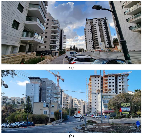
Urban renewal strategy: The renewal plan, Plan HP/2281, was approved in 2011. Building layouts and locations were different from existing plans. The renewed site includes seven renewed buildings, four of which are fifteen stories high and three nine stories high, for a total of 370 resident units. The construction began in 2018. However, when the construction began, the number of resident units increased to 484, more than tripling the old unit’s density. The construction includes parking lots and ancillary services for the tenants’ well-being, such as a sports club, a tenants’ club, and transformation rooms, all within the private plots. Additional public parking was developed along the street, and additional routes and parking were added at the bottom of the site. The wild public open area around the building was reduced, and a designed open area was developed between the buildings and up the street. The part of Berl-Katzenelson Street included in the developed site was transformed from a one-way street to a two-way street (
Figure 2 and
Figure 3). With this strategy, the residents took part in a public participation process.
Haviva-Reich Site:
Before the renewal process: The Haviva-Reich site is located in the heart of the Ramot-Remez neighborhood, which was developed during the 1950s and 1960s. The site is within walking distance of one of the northern city’s significant commercial centers and lies between two major universities, the Technion-IIT (Technion-Israel Institute of Technology) and Haifa University. The renewed area comprises 15 buildings located along one main rounded street, with one entrance and two exits. A natural forest surrounds the area, at the center of which lies a green nature reserve area. The area was developed along a slope, partly steep and partly moderate. The buildings are three to four stories in height and include around 330 small housing units of identical two-bedroom apartments. Between the buildings are wide-open green areas of around 20 m and longer. The housing density is five units per acre. The parking spots are public, spread along the street, with no private parking inside the building plots. The area’s walkability is comfortable, with sidewalks, leading to main streets, a neighborhood center, schools, and universities. The main rounded street, Haviva-Reich Street, is served continually by three bus lines, several times an hour throughout the day. The residents are mostly elderly and young students. The neighborhood’s statistical cluster level is 6–7 (out of 10). All infrastructure is outdated and crumbling [
19].
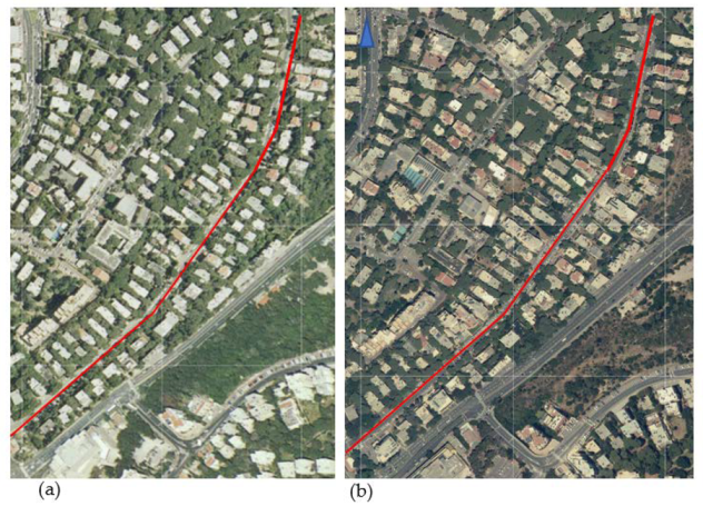
Urban renewal strategy: The renewal plan includes fifteen buildings eight or nine stories tall located along Haviva-Reich Street, in a similar layout and location of the demolished buildings (
Figure 4 and
Figure 5). The open area between buildings was reduced and left with one large open area at the center of the neighborhood. The developed plan comprises residence units and several commercial areas. The first building was developed under a system of reinforcement against earthquakes by extending the original apartments and adding three floors to the roof, doubling the number of housing units. The masterplan was updated in 2007 when the development mechanism changed to demolishing the old buildings and building new ones. This plan enabled the addition of five to six more floors and up to 27 m of height as well as the tripling of the units’ density, resulting in around 930 residential units. The number of parking units was reduced to one per new apartment, and the public parking along the street was reduced. Although the site was developed as one plan, each building was developed by a separate entrepreneur, and their profits come from the sale of the new apartments [
19]. In this strategy, the residents were not involved in any public participation process; furthermore, the site’s residents objected to the design plan [
19].
De-Israeli Site
Before the renewal process: The De-Israeli site is located in the heart of the Carmel neighborhood, which was established around the 1920s, mainly for wealthy family homes. The neighborhood is located adjacent to one of the city’s commercial centers, which constitutes the southern end of the municipal business center of Carmel ridge in Haifa. The De-Israeli site is located along a one-way street that is relatively flat and has one entrance and one exit, with old trees along the sidewalks. The buildings were developed individually (under the outline plans of the City of Haifa) over the years, mainly before 1990. The buildings are around four or five stories tall, and they include diverse three- and four-bedroom apartments. The De-Israeli site includes around 550–600 housing units along the entire street, with a density of approximately 6 units per dunam (1000 sq. m.), which is a medium-to-low density. The site’s public parking spots are spread along the street, and some of the building lots include several private parking spaces. The housing residents are diverse, mainly families and the elderly. The neighborhood’s statistical cluster level is 7–9 (out of 10). The infrastructure is partly outdated and crumbling. Two elementary schools are located at one end of the street (a religious state school and a private school), as are several types of freelancer offices.
Urban renewal strategy: The renewal planning is based on the TAMA38 plan (approved in 2005), a national outline plan that supports old buildings’ residents in strengthening their buildings against earthquakes by providing economic incentives for extensive construction development, such as adding residential units, balconies, rooms, and parking areas (
Figure 6 and
Figure 7). Each building’s renewal development is managed and constructed individually, detached from the adjacent buildings, with no comprehensive masterplan for the site and no municipal intervention in the public open area. The TAMA38 plan’s potential for the De-Israeli site is to double the number of residential units. However, because there is no comprehensive masterplan and each building’s residents decide individually regarding the building’s renewal, the number of housing units at this time is dynamic and growing. Moreover, there is minimal municipal intervention in the development of the public space, and no public or commercial buildings have been added to this site. In this strategy, the residents are provided a public participation process in the form of a standard objection process conducted separately for each building.
All three sites have many similar geographical features: secondary one-way streets, a circular street with one entrance and one exit (or two), located at a walkable distance from a significant urban center. However, the three urban renewal strategies led to the development of three distinct urban environments.
3. Analysis Results
To evaluate the quality of the three urban renewal strategies, we defined several parameters (31), based on available data, and models and tools for evaluating the criteria for the analysis. We reviewed diverse parameters for the analysis and selected those that met the urban renewal analysis criteria before dividing them into two groups: The first group includes
quantitative parameters (
Table 1), including the starting year of the masterplan, urban renewal strategy and track (municipality), new masterplan and year of approval, process starting and ending years, number of existing residential units, number of approved residential units (first phase, at the first approval stage of the plan), residential units approved (for development permit; received building permission), number of entrepreneurs for the entire site (for the three case studies), responsibility for public open-space development (who is responsible for the open areas’ development and maintenance), parking regulation, and public transportation. The second is
urban environmental quality parameters (
Table 2), including resulting residential density in the renewed site, changes in public open areas and green areas, responsibility for the development of public open spaces, public open spaces (in relation to the area), private open spaces (in relation to the area), vegetation (reduction or incision), changes in the road network, changes in public transportation (number of buses and frequency), private transportation, traffic load, parking (reduction or incision), bicycle path, walkability (measure by map whether the walkability is improved), visibility (the views from the buildings and from the street level [
48]), new public building development, access to public and commercial services, mixed-use, public participation (discovering the process), change in population identification (gentrification), and execution phase examination. The tools for analyzing the quality and performance aspects were validated in previous research [
9], including visibility [
48] and walkability [
49].
Table 1 presents the findings for the basic parameters and
Table 2 presents the findings for the urban environmental quality parameters.
Table 1 shows the differences between the three urban renewal strategies in relation to the quantitative parameters. The evaluation indicates the basic differences between the three strategies as the developed plan, the number of entrepreneurs for the entire site, or the starting year for the masterplan. However, it also shows several similarities between the strategies but with different local results due to the differences between locations and urban renewal strategies. One example is the number of approved residential units (with development permits) that triple the residential units (relatively) in each site followed by a significant increase in the density of the site. Another example may be the similarity of the parking standard that results in parking density in the public street areas for all strategies. A comparative evaluation of the quantitative parameters indicates that differences in the results of these parameters can reflect similarly on the outcome of an urban renewal project, as in similar quantitative parameters.
Table 2 shows the differences between the three urban renewal strategies in relation to the quality parameters at several levels. The comparable evaluation indicates a decrease in quality between the three strategies in relation to open public and private spaces and vegetation. The evaluation indicates no change in several qualities, such as the road network, public transport, bicycle paths, walkability, mixed uses, and access to public and commercial services. However, the evaluation indicates increased levels in several parameters that influence the quality of the site, including traffic load, public parking, and visibility at lower levels. Several parameters point out aspects that may have a stronger influence on levels of quality: the municipality’s responsibility for the development of open public spaces, public participation, the execution of examinations for phases, and the additional development of new public buildings. These parameters have a wide impact on the overall quality of the urban renewal complex depending on their implementation in various planning stages.
4. Discussion
The three urban renewal projects presented in this study demonstrate the difficulties and successes of urban renewal processes as well as their complexity. Currently, the urban renewal process in the State of Israel is mainly focused on the economic aspect and the supply of new apartments to the housing market [
21]. However, as studies have shown, this goal is characterized by many problems, including social problems, transportation problems, land-use problems, and severe damage to nature, which are not addressed in the current urban renewal planning policy. Therefore, there is a need for a change in the main goal of urban renewal, which should enhance the renewed area’s public open space according to the existing population’s needs and desires. The three case studies’ analysis results revealed several recommendations and improvement suggestions for the urban renewal process of the site and the neighborhood, and they highlighted diverse problems that emerged as insights from the analysis. Following is a summary of the insights and a presentation of the improvement suggestions.
The need for planning with a comprehensive vision—in preparing the masterplan, an inclusive vision is necessary that includes the area surrounding the urban renewal site and its constraints. It should ensure the maximum utilization of the land’s resources while maintaining the existing urban fabric, with optimal planning tailored to the neighborhood. An inclusive vision should be implemented in demolition and reconstruction sites as well as in areas where TAMA38 is implemented. Another goal is to renew the infrastructure and landscape, among other elements, and avoid disruption to the residents’ site.
Combining old and new development—additional construction that can be approved for existing buildings may damage a building’s exterior and cause old and new buildings to clash in appearance. Extensive construction additions to existing old buildings can be a planning and design challenge [
18]. The goal is to reduce the effect of increasing a building’s influence on surrounding buildings while devoting planning to ensure the building’s integration into its environment [
18].
Building typologies—recommendations to the local authority to produce a catalog of building typologies suitable to build in the renewed site during the urban renewal process, taking into consideration the neighborhood’s topography, location, and socioeconomic level. Developers offer building typologies and layout locations based on their experience, sometimes regardless of local situations, and lack tools for preserving old buildings. Additionally, architectural solutions for TAMA38 cannot be produced for all construction-related and residential needs because of constraints.
Preserving existing natural values—cutting down large numbers of trees on behalf of urban renewal is an ongoing problem. The original natural area values cannot be preserved in any of the renewed routes examined. Emphasis should be placed on the existing natural areas during preparation for the urban renewal process. There is a need to integrate existing and planned trees, consider existing water sources, find original solutions to incorporate them into the landscape, and treat these solutions as valuable resources.
Changing the neighborhood characters—urban renewal, including TAMA38, allows for increasing buildings’ volume by adding housing units to and expanding existing buildings. Additionally, renewal programs allow for the demolition of old buildings and the construction of new buildings by expanding the structure contour in relation to the lot size. The urban fabric affects changes in the surrounding and distant environment for each renewed building or for a whole site, with no preservation of the previous site’s qualities, such as its density and traffic. The municipality promotes strengthening buildings and building additions as incentives for developers, even at the cost of changing the nature of the environment and the neighborhood.
Include predefined execution stages for the renewal plan—in contrast to the advantages of one entrepreneur (the case of the Berl-Katzenelson site) who manages the planning and execution stages, execution vis-à-vis municipality features advantages in the number of entrepreneurs (Haviva-Reich and TAMA38 projects), mainly related to the creation of a competition for architectural quality and construction and apartment prices. However, the most important step is defining execution steps in the plan to avoid disruptions to the local residents’ daily routines.
Construction density—although the main objectives guiding local authorities’ urban renewal processes are the economic and legal aspects, the solution of increasing the density multiplier is not suitable for all urban renewal projects. Therefore, there is a need to include the social and physical aspects. Moreover, additional residential units in the existing urban fabric may burden the road system and cause traffic congestion. Our recommendation is to define a mechanism for determining the multipliers for the number of residents in accordance with the type of urban renewal route, the neighborhood’s size, geographical and topographic location, land value, market price levels, and other factors. A process is necessary to establish criteria that include the designer’s and contractor’s competitive parameters and allow for the selection of a designer and contractor based on the environment’s target quality after renewal.
Gentrification and change in population composition—the solution for gentrification must include the authorities. It is necessary to provide solutions for diverse populations that enable all residents to return at the end of construction.
Public buildings and mixed-use—the process of urban renewal requires the construction of additional public buildings. Therefore, it is necessary to include areas for public construction in the renewed masterplans.
Administrative division of urban renewal—the administrative division of urban renewal is a unit of the local authority for promoting urban renewal processes, simplifying these processes, making information accessible to residents, assisting professionals in the urban renewal field, and bridging the gap between the local authority and the residents to accelerate urban renewal processes. A comprehensive vision is necessary to influence the urban renewal plan and process, regardless of which route will be taken.
Public participation—public participation is highly important for urban renewal processes. The process should include relevant professionals (planners, social workers, legal advisers, etc.), representatives of the local authority, entrepreneurs, local residents, and any other party required. In many cases, tenants attempt to organize and work together with the authority, which works poorly because of their lack of knowledge, the apartment owners’ professionalism, and a lack of trust in the local authority. Therefore, it is recommended that municipalities incorporate social counselors to advance information processes even before urban renewal procedures begin.
Determining the road network—the analysis shows that the three case studies neglected planning regarding road networks and required treatment at the intersections leading out of the neighborhoods. In all cases, the main roads remain single-road streets, each with a single entrance and a school. The renewal plans neglect the increases in the sites’ populations and in the numbers of vehicles in the neighborhoods. Renewal plans need to include the redefinition of road networks with clear definitions of secondary and main streets to enhance road networks’ performance following the changes in the population. Furthermore, there is a need to ask whether these locations will be able to adequately address the increased demand created by demographic changes. It should be noted that none of the three routes addressed the transportation problems, and it is impossible to determine whether one route is more effective than the others. Following this structure, the walkability did not change or increase in any of the three case studies.
Public transportation—urban renewal and public transportation must be interconnected. Neglecting this integration may cause traffic problems in the renewed area, as the three case studies show.
Parking standard and development plan—parking needs to be reflected in renewal plans to ensure that streets are clear of cars for the residents’ benefit. The design needs to address walkability, connectivity, and bike lanes inside and outside the neighborhood, reduce parking areas in public open spaces, and develop public transportation. Demolition and reconstruction enable the development of parking inside private lots, including parking facilities that double the parking area, and allow more cars to park inside private lots.
To conclude, one of the most important objectives of urban renewal is to develop public infrastructure throughout the renewal design and development process. Doing so will strengthen the urban renewal site, ensure the high quality of the new buildings, and enhance the renewed area’s quality and performance.
5. Conclusions
We compared three urban renewal strategies in which buildings were demolished and rebuilt to improve the old buildings’ resistance to earthquakes and renew the neighborhood: The urban renewal strategy for the Berl-Katzenelson site provides a comprehensive solution that combined the private interest with the public interest. The urban renewal strategy for the Haviva-Reich site provides a comprehensive solution that was carried out in a fragmented manner. The urban renewal strategy for the De-Israeli site is based on the TAMA38 plan and involves demolishing and rebuilding each old building separately, with no comprehensive plan. All three case studies show that the demolition and reconstruction of the evacuation–construction urban renewal route the most effectively creates a comprehensive urban renewal process.
TAMA38 is a national program that leads to urban renewal in many cities. Therefore, this research is important beyond the city of Haifa. A thorough understanding of strategies for urban renewal that are based on the TAMA38 plan can also influence the development of similar urban renewal strategies, tailored to a location, in other cities in Israel to additional cities in different locations in the world. Haifa is a hilly city with a high demand for cars; therefore, additional parking in open public spaces is needed. However, in this research, we identified several other parameters that are important to implement in strategies for urban renewal and in different areas of the country, such as a municipality’s responsibility for the development of public open spaces and the examination of the phases of execution, leading to the promotion of urban renewal based on the TAMA38 plan.
There is no doubt that the economic aspect is highly important, but at the same time, the choice of urban renewal strategy cannot ignore the planning of public open spaces and the built environment as a comprehensive environment, as well as many other considerations mentioned above, which need to be taken into consideration before the urban renewal process begins. It is necessary for the local authority to determine the urban renewal policy in relation to the developers and residents as early as possible. Furthermore, the authority needs to take responsibility for the planning of the public open spaces in all phases, from planning to settling, the completion of infrastructure planning, and work on the open space, including dealing with the developers and contractors.
Nevertheless, it is necessary to achieve a balance among desires to renew private buildings, preserve private properties, and upgrade public open spaces. TAMA38 was developed in 2005 and will be completed around 2023, mainly due to the focus on the buildings and the limited attention directed toward the public open spaces. Urban renewal processes entail many opportunities to improve the urban environment and enhance its quality.
The current research bears several limitations, for example, there is a lack of knowledge regarding the residents’ satisfaction (existing and newcomers) with the three sites of their renewed neighborhoods. The residents’ satisfaction can affect the behavior of the residents in the neighborhood. The topic is very important and affects the way the residents use the site area, so future comprehensive research would need to include the residents’ satisfaction as an important aspect of perpetual research. An additional limitation of this study is the data and information it is based on—public information available for all three strategies and case studies. Future research needs to take into consideration the outcomes of this research while selecting the urban renewal strategy of an urban site. It is necessary to develop a comprehensive urban renewal model based on the TAMA38 plan that incorporates open public spaces and uses for the benefit of the urban renewal site, its neighborhood, and the surrounding areas.
To conclude, there are many varied constraints, conditions, circumstances, and considerations to remember in the selection of the best concepts and strategies for urban renewal processes. Therefore, it is very important to decide which urban strategy is the best tailored to a specific site in a specific location in a city as well as to the residents to improve the development of urban renewal strategies for future urban renewal.


