
Geospatial Technology for Sustainable Agricultural Water Management in India—A Systematic Review
 , , ,
, , ,
Abstract
:1. Introduction
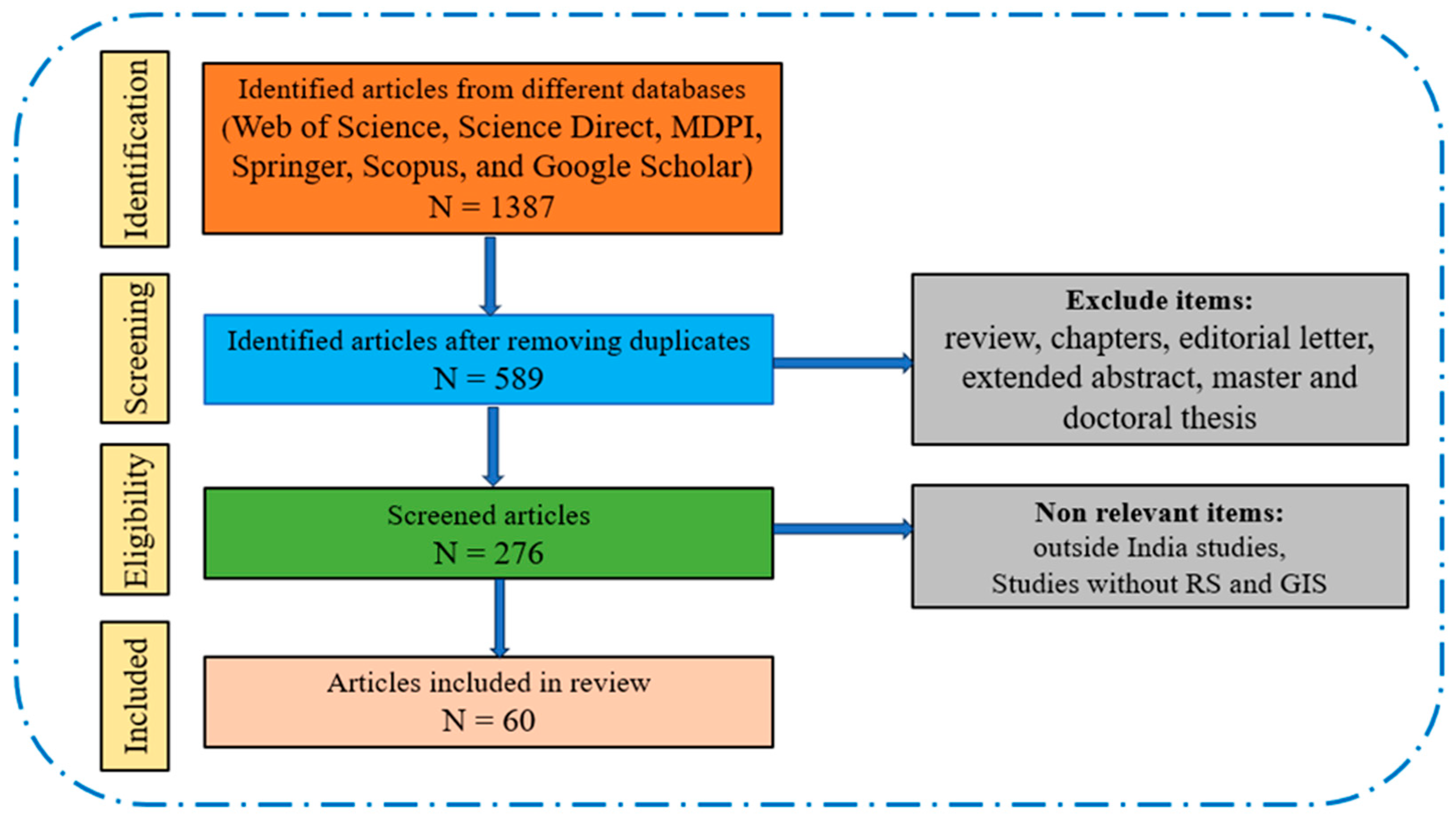
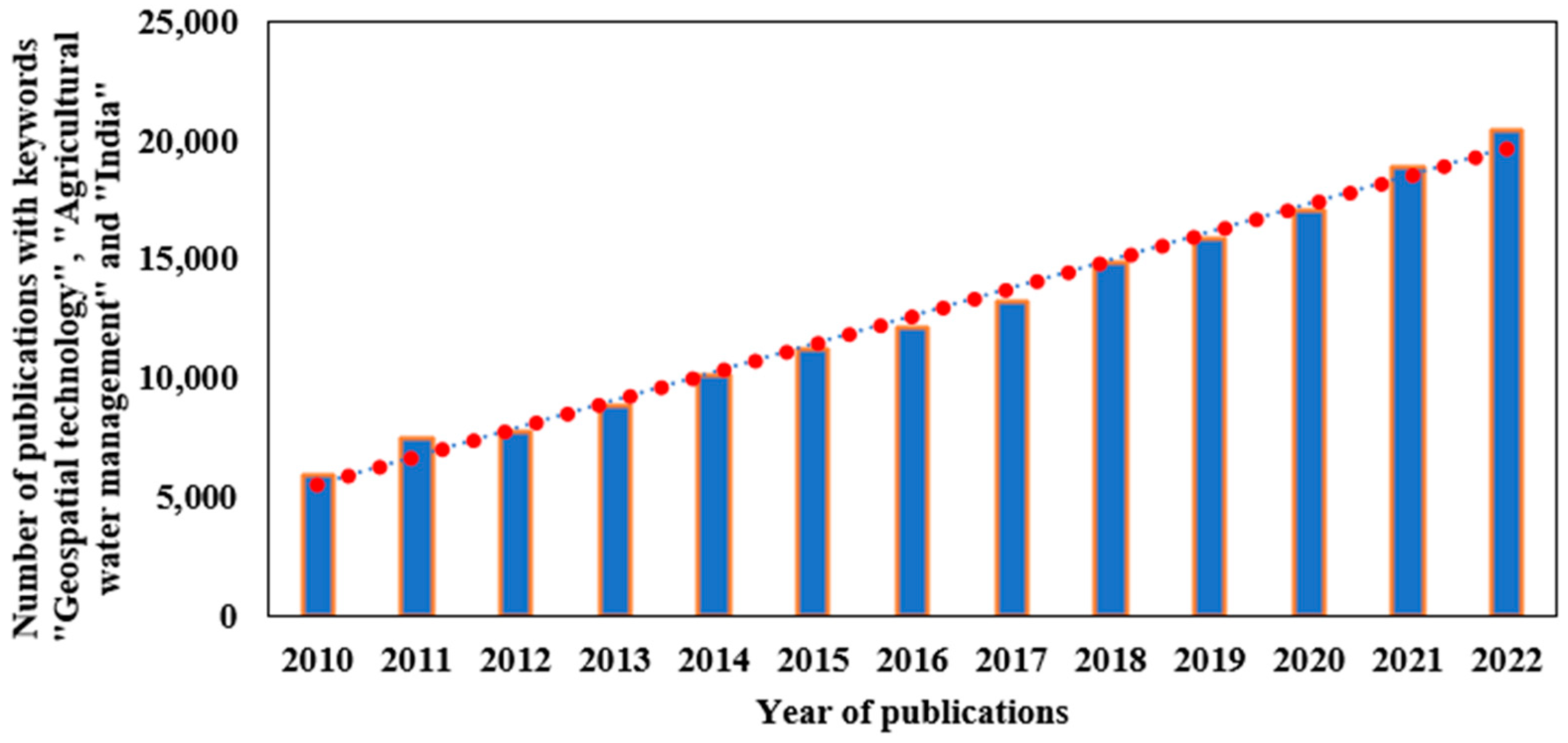
2. Research Method and Literature Search
Systematic Literature Review
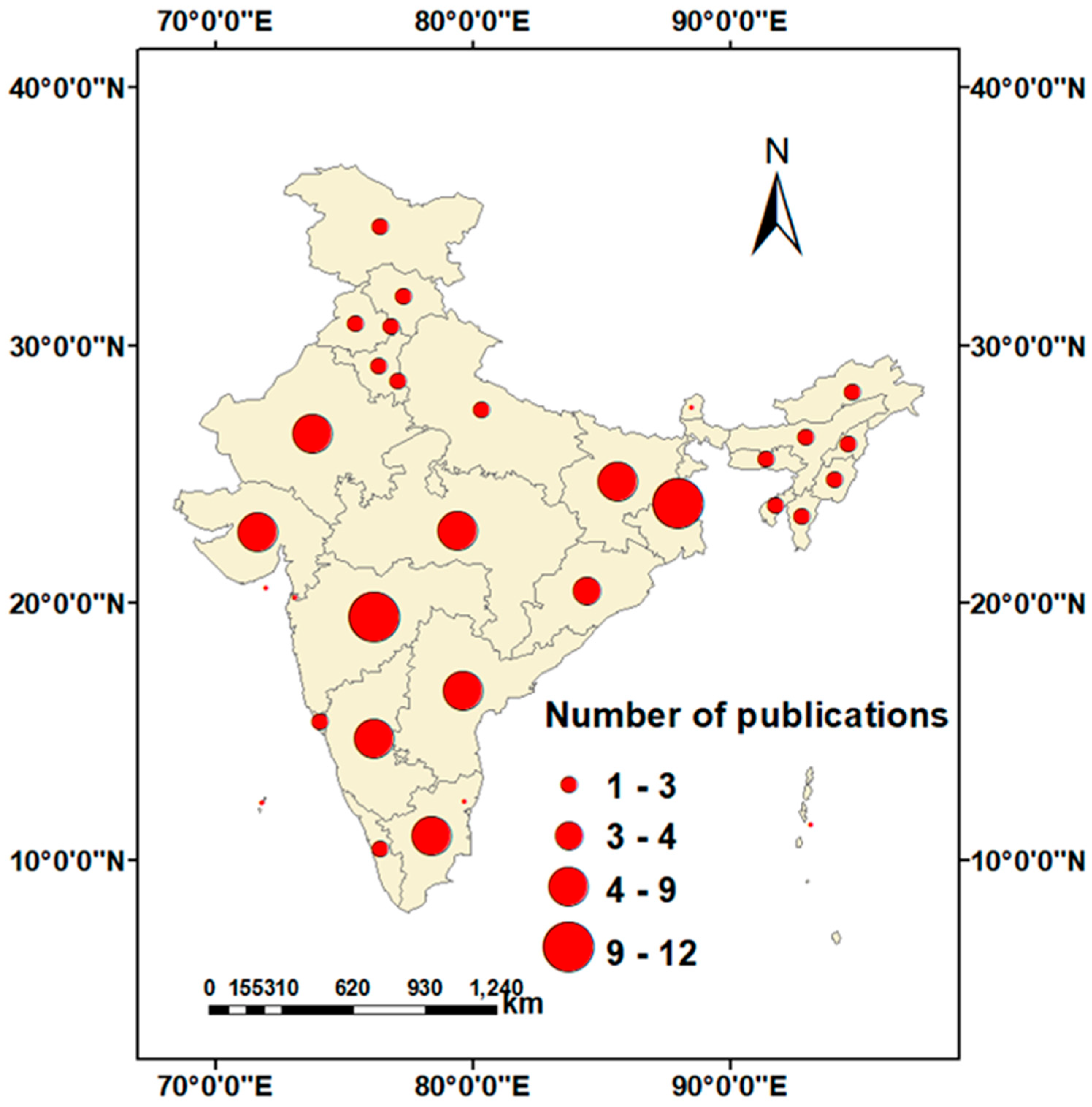
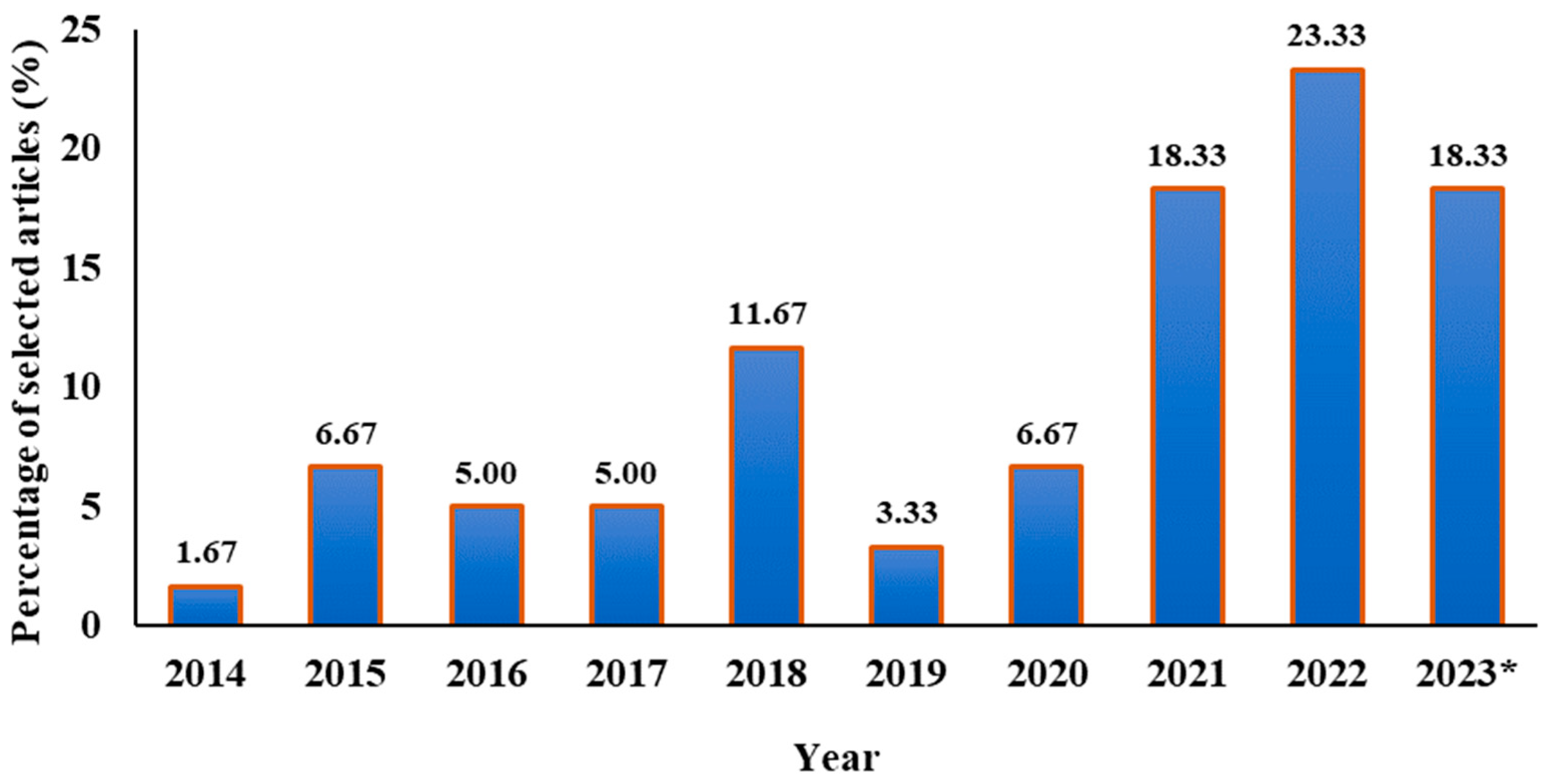
3. Results
3.1. Evapotranspiration (ET), Irrigation Water Requirement, and Water Productivity Estimation
3.2. Drought Assessment and Monitoring
3.3. Runoff Estimation from Agriculture Watersheds
3.4. Water Body and Waterlogged Area Mapping
3.5. Identification of Suitable Sites for Groundwater Recharge and Rainwater Harvesting
3.6. Soil Moisture Estimation
4. Discussion
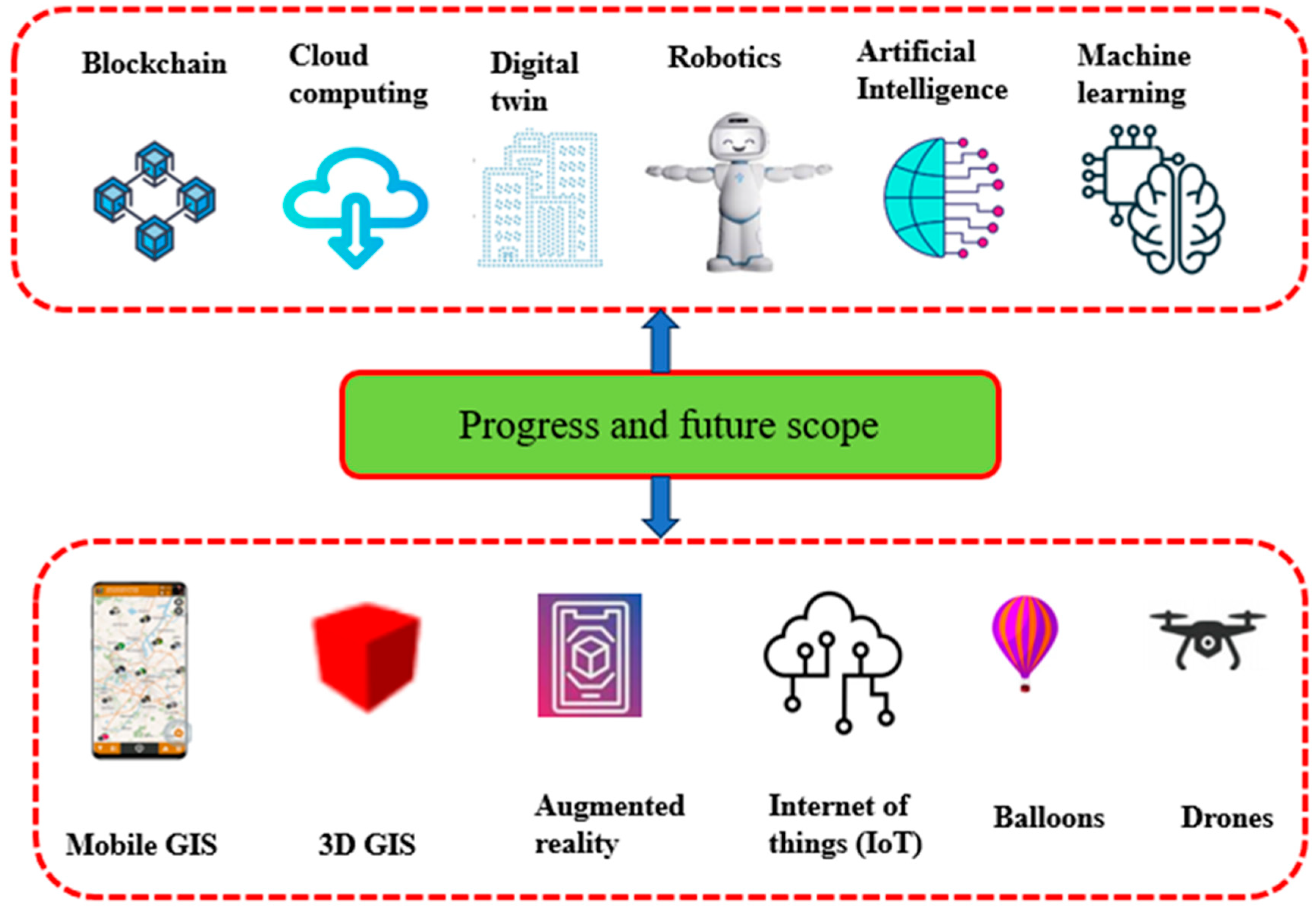
5. Progress and Future Scope
6. Conclusions
Author Contributions
Funding
Data Availability Statement
Conflicts of Interest
References
- Anusha, B.N.; Babu, K.R.; Kumar, B.P.; Kumar, P.R.; Rajasekhar, M. Geospatial Approaches for Monitoring and Mapping of Water Resources in Semi-Arid Regions of Southern India. Environ. Chall. 2022, 8, 100569. [Google Scholar] [CrossRef]
- Tripathi, A.; Tiwari, R.K. Synergetic Utilization of Sentinel-1 SAR and Sentinel-2 Optical Remote Sensing Data for Surface Soil Moisture Estimation for Rupnagar, Punjab, India. Geocarto Int. 2022, 37, 2215–2236. [Google Scholar] [CrossRef]
- Singh, P.K.; Jain, S.K.; Mishra, P.K.; Goel, M.K. An Assessment of Water Consumption Patterns and Land Productivity and Water Productivity Using WA+ Framework and Satellite Data Inputs. Phys. Chem. Earth Parts A/B/C 2022, 126, 103053. [Google Scholar] [CrossRef]
- Virnodkar, S.S.; Pachghare, V.K.; Patil, V.C.; Jha, S.K. Remote Sensing and Machine Learning for Crop Water Stress Determination in Various Crops: A Critical Review. Precis. Agric. 2020, 21, 1121–1155. [Google Scholar] [CrossRef]
- Pokhariyal, S.; Patel, N.R.; Govind, A. Machine Learning-Driven Remote Sensing Applications for Agriculture in India—A Systematic Review. Agronomy 2023, 13, 2302. [Google Scholar] [CrossRef]
- Chintalacheruvu, M.R.; Bardhan, A.; Pingale, S.M.; Patra, J.P. Water Footprint Analysis for the Upper Baitarani River Basin, India. Sustain. Water Resour. Manag. 2022, 8, 181. [Google Scholar] [CrossRef]
- Kesarwani, M.; Neeti, N.; Chowdary, V.M. Evaluation of Different Gridded Precipitation Products for Drought Monitoring: A Case Study of Central India. Theor. Appl. Climatol. 2023, 151, 817–841. [Google Scholar] [CrossRef]
- Shah, R.; Bharadiya, N.; Manekar, V. Drought Index Computation Using Standardized Precipitation Index (SPI) Method For Surat District, Gujarat. Aquat. Procedia 2015, 4, 1243–1249. [Google Scholar] [CrossRef]
- Patel, N.R.; Pokhriyal, S.; Singh, R.P. Advancements in Remote Sensing Based Crop Yield Modelling in India. J. Agrometeorol. 2023, 25, 293–299. [Google Scholar] [CrossRef]
- Balas, D.B.; Tiwari, M.K.; Patel, G.R. Estimation of Surface and Subsurface Soil Moisture Using Microwave Remote Sensing: A Typical Analysis. Int. J. Environ. Clim. Chang. 2023, 13, 1804–1816. [Google Scholar] [CrossRef]
- Shah, D.; Mishra, V. Integrated Drought Index (IDI) for Drought Monitoring and Assessment in India. Water Resour. Res. 2020, 56, e2019WR026284. [Google Scholar] [CrossRef]
- Dutta, D.; Kundu, A.; Patel, N.R.; Saha, S.K.; Siddiqui, A.R. Assessment of Agricultural Drought in Rajasthan (India) Using Remote Sensing Derived Vegetation Condition Index (VCI) and Standardized Precipitation Index (SPI). Egypt. J. Remote Sens. Sp. Sci. 2015, 18, 53–63. [Google Scholar] [CrossRef]
- Ravichandran, V.; Kantamaneni, K.; Periasamy, T.; Roy, P.D.; Killivalavan, J.; Sundar, S.; Chokkalingam, L.; Palanisamy, M. Monitoring of Multi-Aspect Drought Severity and Socio-Economic Status in the Semi-Arid Regions of Eastern Tamil Nadu, India. Water 2022, 14, 2049. [Google Scholar] [CrossRef]
- Chattopadhyay, N.; Malathi, K.; Tidke, N.; Attri, S.D.; Ray, K. Monitoring Agricultural Drought Using Combined Drought Index in India. J. Earth Syst. Sci. 2020, 129, 155. [Google Scholar] [CrossRef]
- Kulkarni, S.S.; Wardlow, B.D.; Bayissa, Y.A.; Tadesse, T.; Svoboda, M.D.; Gedam, S.S. Developing a Remote Sensing-Based Combined Drought Indicator Approach for Agricultural Drought Monitoring over Marathwada, India. Remote Sens. 2020, 12, 2091. [Google Scholar] [CrossRef]
- Bageshree, K.; Abhishek; Kinouchi, T. A Multivariate Drought Index for Seasonal Agriculture Drought Classification in Semiarid Regions. Remote Sens. 2022, 14, 3891. [Google Scholar] [CrossRef]
- Mishra, S.; Mahammood, V.; Durga Rao, K.H.V. Assessment of Irrigation Performance by Using Remote Sensing Techniques in Naryanpur Command Area, India. Environ. Ecol. Res. 2022, 10, 370–384. [Google Scholar] [CrossRef]
- Parmar, S.H.; Patel, G.R.; Tiwari, M.K. Assessment of Crop Water Requirement of Maize Using Remote Sensing and GIS. Smart Agric. Technol. 2023, 4, 100186. [Google Scholar] [CrossRef]
- Mukherjee, J.; Sharma, A.; Dhakar, R.; Sehgal, V.K.; Chakraborty, D.; Das, D.K. Estimation and Validation of Actual Evapotranspiration (ETa) of Maize Wheat Cropping System Using SSEBop Model Over IARI Research Farm, New Delhi, India. J. Indian Soc. Remote Sens. 2021, 49, 1823–1837. [Google Scholar] [CrossRef]
- Sindhu, D.; Shivakumar, B.L.; Ravikumar, A.S. Estimation of Surface Runoff in Nallur Amanikere. Int. J. Res. Eng. Technol. 2013, 404–409. [Google Scholar]
- Deoli, V.; Kumar, D.; Kumar, M.; Kuriqi, A.; Elbeltagi, A. Water Spread Mapping of Multiple Lakes Using Remote Sensing and Satellite Data. Arab. J. Geosci. 2021, 14, 2213. [Google Scholar] [CrossRef]
- Jhariya, D.C.; Kumar, T.; Gobinath, M.; Diwan, P.; Kishore, N. Assessment of Groundwater Potential Zone Using Remote Sensing, GIS and Multi Criteria Decision Analysis Techniques. J. Geol. Soc. India 2016, 88, 481–492. [Google Scholar] [CrossRef]
- Kanmani, K.; Vasanthi, P.; Pari, P.; Shafeer Ahamed, N.S. Estimation of Soil Moisture for Different Crops Using SAR Polarimetric Data. Civ. Eng. J. 2023, 9, 1402–1411. [Google Scholar] [CrossRef]
- Singh, L.K.; Jha, M.K.; Chowdary, V.M. Multi-Criteria Analysis and GIS Modeling for Identifying Prospective Water Harvesting and Artificial Recharge Sites for Sustainable Water Supply. J. Clean. Prod. 2017, 142, 1436–1456. [Google Scholar] [CrossRef]
- Anuradha, B.; Packialakshmi, S.; Sanjay, N.; Vivekananthan, V. An Analytical Study for Assessing Water Productivity in Pre- and Post-Rehabilitation Period of Rural Tank System. Adv. Civ. Eng. 2022, 2022, 1119931. [Google Scholar] [CrossRef]
- Ajay Kumar, V.; Mondal, N.C.; Ahmed, S. Identification of Groundwater Potential Zones Using RS, GIS and AHP Techniques: A Case Study in a Part of Deccan Volcanic Province (DVP), Maharashtra, India. J. Indian Soc. Remote Sens. 2020, 48, 497–511. [Google Scholar] [CrossRef]
- Saranya, T.; Saravanan, S. Groundwater Potential Zone Mapping Using Analytical Hierarchy Process (AHP) and GIS for Kancheepuram District, Tamilnadu, India. Model. Earth Syst. Environ. 2020, 6, 1105–1122. [Google Scholar] [CrossRef]
- Singh, L.K.; Jha, M.K.; Chowdary, V.M. Planning Rainwater Conservation Measures Using Geospatial and Multi-Criteria Decision Making Tools. Environ. Sci. Pollut. Res. 2021, 28, 1734–1751. [Google Scholar] [CrossRef]
- Asgher, M.S.; Kumar, N.; Kumari, M.; Ahmad, M.; Sharma, L.; Naikoo, M.W. Groundwater Potential Mapping of Tawi River Basin of Jammu District, India, Using Geospatial Techniques. Environ. Monit. Assess. 2022, 194, 240. [Google Scholar] [CrossRef]
- Yadav, B.; Patidar, N.; Sharma, A.; Panigrahi, N.; Sharma, R.K.; Loganathan, V.; Krishan, G.; Singh, J.; Kumar, S.; Parker, A. Assessment of Traditional Rainwater Harvesting System in Barren Lands of a Semi-Arid Region: A Case Study of Rajasthan (India). J. Hydrol. Reg. Stud. 2022, 42, 101149. [Google Scholar] [CrossRef]
- Jayswal, P.S.; Gontia, N.K.; Sondarva, K.N.; Patel, V.A. Site Selection for Rainwater Harvesting Using Remote Sensing, GIS and AHP. Int. J. Plant Soil Sci. 2023, 35, 1360–1378. [Google Scholar] [CrossRef]
- Meraj, G.; Kanga, S.; Ambadkar, A.; Kumar, P.; Singh, S.K.; Farooq, M.; Johnson, B.A.; Rai, A.; Sahu, N. Assessing the Yield of Wheat Using Satellite Remote Sensing-Based Machine Learning Algorithms and Simulation Modeling. Remote Sens. 2022, 14, 3005. [Google Scholar] [CrossRef]
- Kingra, P.K.; Majumder, D.; Singh, S.P. Application of Remote Sensing and Gis in Agriculture and Natural Resource Management Under Changing Climatic Conditions. Agric. Res. J. 2016, 53, 295. [Google Scholar] [CrossRef]
- Bhat, Y.; Nandy, S.; Padalia, H.; Nath, A.J.; Pebam, R. Role of Geospatial Technology in Shifting Cultivation Studies in India: A Systematic Review. J. Indian Soc. Remote Sens. 2022, 50, 2359–2379. [Google Scholar] [CrossRef]
- Cravero, A.; Pardo, S.; Sepúlveda, S.; Muñoz, L. Challenges to Use Machine Learning in Agricultural Big Data: A Systematic Literature Review. Agronomy 2022, 12, 748. [Google Scholar] [CrossRef]
- Mashala, M.J.; Dube, T.; Mudereri, B.T.; Ayisi, K.K.; Ramudzuli, M.R. A Systematic Review on Advancements in Remote Sensing for Assessing and Monitoring Land Use and Land Cover Changes Impacts on Surface Water Resources in Semi-Arid Tropical Environments. Remote Sens. 2023, 15, 3926. [Google Scholar] [CrossRef]
- Shwetha, H.R.; Kumar, D.N. Estimation of Daily Actual Evapotranspiration Using Vegetation Coefficient Method for Clear and Cloudy Sky Conditions. IEEE J. Sel. Top. Appl. Earth Obs. Remote Sens. 2020, 13, 2385–2395. [Google Scholar] [CrossRef]
- Jaiswal, R.K.; Lohani, A.K.; Galkate, R.V. Rainfall and Agro Related Climate Extremes for Water Requirement in Paddy Grown Mahanadi Basin of India. Agric. Res. 2023, 12, 20–31. [Google Scholar] [CrossRef]
- Parmar, H.V.; Gontia, N.K. Evapotranspiration Estimation Using Surface Energy Balance-Based Evaporative Fraction for Water Management in Canal Irrigation Command. J. Indian Soc. Remote Sens. 2022, 50, 373–384. [Google Scholar] [CrossRef]
- Kumar, U.; Srivastava, A.; Kumari, N.; Rashmi; Sahoo, B.; Chatterjee, C.; Raghuwanshi, N.S. Evaluation of Spatio-Temporal Evapotranspiration Using Satellite-Based Approach and Lysimeter in the Agriculture Dominated Catchment. J. Indian Soc. Remote Sens. 2021, 49, 1939–1950. [Google Scholar] [CrossRef]
- Adamala, S.; Rajwade, Y.A.; Reddy, Y.V.K. Estimation of Wheat Crop Evapotranspiration Using NDVI Vegetation Index. J. Appl. Nat. Sci. 2016, 8, 159–166. [Google Scholar] [CrossRef]
- Mondal, I.; Thakur, S.; De, A.; De, T.K. Application of the METRIC Model for Mapping Evapotranspiration over the Sundarban Biosphere Reserve, India. Ecol. Indic. 2022, 136, 108553. [Google Scholar] [CrossRef]
- Ramesh, J.; Jella, K.; Jogu, V. Evapotranspiration Estimation Using Geo-Spatial Techniques. Int. J. Sci. Res. Dev. 2021, 8, 217–220. [Google Scholar]
- Rao, J.H.; Hardaha, M.K.; Vora, H.M. The Water Footprint Assessment of Agriculture in Banjar River Watershed. Curr. World Environ. 2019, 14, 476–488. [Google Scholar] [CrossRef]
- Chanu, B.N.; Oinam, B. Assessment of Crop Yield and Water Footprint of Kharif Paddy Production under Different Rainfall Years. Songklanakarin J. Sci. Technol. 2023, 45, 451–455. [Google Scholar]
- Paul, G.C.; Saha, S. Measuring the Crop Water Demand and Satisfied Degree Using Remote Sensing Data and Machine Learning Method in Monsoon Climatic Region, India. Environ. Sci. Pollut. Res. 2023. ahead of print. [Google Scholar] [CrossRef] [PubMed]
- Madane, D.A.; Singh, M.C.; Sharma, P.; Mane, M. Water and Carbon Footprint Assessment of Onion Crop Cultivated under Differential Irrigation Scenarios. Arab. J. Geosci. 2023, 16, 419. [Google Scholar] [CrossRef]
- Sesha Sai, M.V.R.; Murthy, C.S.; Chandrasekar, K.; Jeyaseelan, A.T.; Diwakar, P.G.; Dadhwal, V.K. Agricultural Drought: Assessment & Monitoring. Mausam 2016, 67, 131–142. [Google Scholar]
- Sarkar, S. Drought and Flood Dynamics of Godavari Basin, India: A Geospatial Perspective. Arab. J. Geosci. 2022, 15, 772. [Google Scholar] [CrossRef]
- Deiveegan, M.; Pazhanivelan, S.; Ragunath, K.P.; Kumaraperumal, R. Detection of Agricultural Vulnerability to Drought Using NDVI and Land Surface Temperature in Salem and Namakkal Districts of Tamil Nadu. Adv. Life Sci. 2016, 5, 6868–6873. [Google Scholar]
- Nyayapathi, P.; Penki, R.; Basina, S.S. Drought Vulnerability Assessment by Employing the Geographical Information System and Analytical Hierarchy Process for the Kurnool District of Andhra Pradesh, India. Ecocycles 2023, 9, 32–48. [Google Scholar] [CrossRef]
- Sridhara, S.; Chaithra, G.M.; Gopakkali, P. Assessment and Monitoring of Drought in Chitradurga District of Karnataka Using Different Drought Indices. J. Agrometeorol. 2021, 23, 221–227. [Google Scholar] [CrossRef]
- Bajirao, T.S.; Kumar, P. Quantification of Impact of Spatio-Temporal Variability of Land Use/Land Cover on Runoff Generation Using Modified NRCS-CN Method. Arab. J. Geosci. 2022, 15, 610. [Google Scholar] [CrossRef]
- Bera, B.; Shit, P.K.; Sengupta, N.; Saha, S.; Bhattacharjee, S. Trends and Variability of Drought in the Extended Part of Chhota Nagpur Plateau (Singbhum Protocontinent), India Applying SPI and SPEI Indices. Environ. Chall. 2021, 5, 100310. [Google Scholar] [CrossRef]
- Prajapati, V.K.; Khanna, M.; Singh, M.; Kaur, R.; Sahoo, R.N.; Singh, D.K. PCA–Based Composite Drought Index for Drought Assessment in Marathwada Region of Maharashtra State, India. Theor. Appl. Climatol. 2022, 149, 207–220. [Google Scholar] [CrossRef]
- Palagiri, H.; Pal, M.; Maity, R. Drought Monitoring Using Satellite Soil Moisture Data Over Godavari Basin, India. In Lecture Notes in Civil Engineering; Springer: Berlin/Heidelberg, Germany, 2023; pp. 1–13. [Google Scholar]
- Das, P.K.; Das, D.K.; Midya, S.K.; Raj, U.; Dadhwal, V.K. Fore-Warning of Early Season Agricultural Drought Condition over Indian Region–a Fractional Wetness Approach. Geocarto Int. 2020, 35, 569–588. [Google Scholar] [CrossRef]
- Vyas, S.S.; Bhattacharya, B.K.; Nigam, R.; Guhathakurta, P.; Ghosh, K.; Chattopadhyay, N.; Gairola, R.M. A Combined Deficit Index for Regional Agricultural Drought Assessment over Semi-Arid Tract of India Using Geostationary Meteorological Satellite Data. Int. J. Appl. Earth Obs. Geoinf. 2015, 39, 28–39. [Google Scholar] [CrossRef]
- Kumaraperumal, R.; Pazhanivelan, S.; Ragunath, K.P.; Kannan, B.; Prajesh, P.J.; Mugilan, G.R. Agricultural Drought Monitoring in Tamil Nadu in India Using Satellite-Based Multi Vegetation Indices. J. Appl. Nat. Sci. 2021, 13, 414–423. [Google Scholar]
- Halder, B.; Tiyasha, T.; Shahid, S.; Yaseen, Z.M. Delineation of Urban Expansion and Drought-Prone Areas Using Vegetation Conditions and Other Geospatial Indices. Theor. Appl. Climatol. 2022, 149, 1277–1295. [Google Scholar] [CrossRef]
- Swain, S.; Mishra, S.K.; Pandey, A.; Dayal, D. Assessment of Drought Trends and Variabilities over the Agriculture-Dominated Marathwada Region, India. Environ. Monit. Assess. 2022, 194, 883. [Google Scholar] [CrossRef]
- Gumma, M.K.; Nelson, A.; Yamano, T. Mapping Drought-Induced Changes in Rice Area in India. Int. J. Remote Sens. 2019, 40, 8146–8173. [Google Scholar] [CrossRef]
- Sruthi, S.; Aslam, M.A.M. Agricultural Drought Analysis Using the NDVI and Land Surface Temperature Data; a Case Study of Raichur District. Aquat. Procedia 2015, 4, 1258–1264. [Google Scholar] [CrossRef]
- Medida, S.K.; Prasuna Rani, P.; Suneel Kumar, G.V.; Geetha Sireesha, P.V.; Kranthi, K.C.; Vinusha, V.; Sneha, L.; Naik, B.S.S.S.; Pramanick, B.; Brestic, M.; et al. Detection of Water Deficit Conditions in Different Soils by Comparative Analysis of Standard Precipitation Index and Normalized Difference Vegetation Index. Heliyon 2023, 9, e15093. [Google Scholar] [CrossRef] [PubMed]
- Sandeep, P.; Obi Reddy, G.P.; Jegankumar, R.; Arun Kumar, K.C. Monitoring of Agricultural Drought in Semi-Arid Ecosystem of Peninsular India through Indices Derived from Time-Series CHIRPS and MODIS Datasets. Ecol. Indic. 2021, 121, 107033. [Google Scholar] [CrossRef]
- Siddi Raju, R.; Sudarsana Raju, G.; Rajasekhar, M. Estimation of Rainfall Runoff Using SCS-CN Method with RS and GIS Techniques for Mandavi Basin in YSR Kadapa District of Andhra Pradesh, India. Hydrospatial Anal. 2018, 2, 1–15. [Google Scholar] [CrossRef]
- Gajbhiye, S. Estimation of Surface Runoff Using Remote Sensing and Geographical Information System. Int. J. u- e-Serv. Sci. Technol. 2015, 8, 113–122. [Google Scholar] [CrossRef]
- Jain, S.; Jaiswal, R.K.; Lohani, A.K.; Galkate, R. Development of Cloud-Based Rainfall–Run-Off Model Using Google Earth Engine. Curr. Sci. 2021, 121, 1433. [Google Scholar] [CrossRef]
- Srivastava, A.; Chinnasamy, P. Investigating Impact of Land-Use and Land Cover Changes on Hydro-Ecological Balance Using GIS: Insights from IIT Bombay, India. SN Appl. Sci. 2021, 3, 343. [Google Scholar] [CrossRef]
- Verma, S.; Singh, A.; Mishra, S.K.; Singh, P.K.; Verma, R.K. Efficacy of Slope-Adjusted Curve Number Models with Varying Initial Abstraction Coefficient for Runoff Estimation. Int. J. Hydrol. Sci. Technol. 2018, 8, 317–338. [Google Scholar] [CrossRef]
- Chanapathi, T.; Thatikonda, S.; Raghavan, S. Analysis of Rainfall Extremes and Water Yield of Krishna River Basin under Future Climate Scenarios. J. Hydrol. Reg. Stud. 2018, 19, 287–306. [Google Scholar] [CrossRef]
- Ibrahim-Bathis, K.; Ahmed, S.A. Rainfall-Runoff Modelling of Doddahalla Watershed—An Application of HEC-HMS and SCN-CN in Ungauged Agricultural Watershed. Arab. J. Geosci. 2016, 9, 170. [Google Scholar] [CrossRef]
- Natarajan, S.; Radhakrishnan, N. Assessment of Rainfall–Runoff Due to the Impacts of Land-Use Changes by Integrated Geospatial Empirical Approach: Study on Koraiyar Basin, Tiruchirappalli City, India. J. Indian Soc. Remote Sens. 2021, 49, 793–812. [Google Scholar] [CrossRef]
- Kumar, A.; Kanga, S.; Taloor, A.K.; Singh, S.K.; Đurin, B. Surface Runoff Estimation of Sind River Basin Using Integrated SCS-CN and GIS Techniques. HydroResearch 2021, 4, 61–74. [Google Scholar] [CrossRef]
- Satheeshkumar, S.; Venkateswaran, S.; Kannan, R. Rainfall–Runoff Estimation Using SCS–CN and GIS Approach in the Pappiredipatti Watershed of the Vaniyar Sub Basin, South India. Model. Earth Syst. Environ. 2017, 3, 24. [Google Scholar] [CrossRef]
- Nagaraj, R.; Kumar, L.S. Multi Scale Feature Extraction Network with Machine Learning Algorithms for Water Body Extraction from Remote Sensing Images. Int. J. Remote Sens. 2022, 43, 6349–6387. [Google Scholar] [CrossRef]
- Mishra, K.; Prasad, P.R.C. Automatic Extraction of Water Bodies from Landsat Imagery Using Perceptron Model. J. Comput. Environ. Sci. 2015, 2015, 903465. [Google Scholar] [CrossRef]
- Chakravorty, B.; Jha, R. Assessment of Spatio-Temporal Variation of Waterlogged Areas Lying Between Lower Gandak and Burhi Gandak Basins, India. J. Indian Soc. Remote Sens. 2022, 50, 583–596. [Google Scholar] [CrossRef]
- Ramji Satyaji Rao, Y. Mapping and Change Detection of Water Bodies in the Godavari Delta Using Geospatial Technology. ADBU-J. Eng. Technol. 2022, 11, 1–6. [Google Scholar]
- Roy Mukherjee, N.; Samuel, C. Assessment of the Temporal Variations of Surface Water Bodies in and around Chennai Using Landsat Imagery. Indian J. Sci. Technol. 2016, 9, 1–7. [Google Scholar] [CrossRef]
- Manoj, N.H.G.; Suresh, K.A.V.; Mani, A. Charectarization of Surface Water Dynamics in Krishna and Godavari River Basin by Using Remote Sensing and GIS Charectarization of Surface Water Dynamics in Krishna and Godavari River Basin by Using Remote Sensing and GIS. Adv. Life Sci. 2018, 5, 7349–7353. [Google Scholar]
- Sreekanth, P.D.; Krishnan, P.; Rao, N.H.; Soam, S.K.; Srinivasarao, C. Mapping Surface-Water Area Using Time Series Landsat Imagery on Google Earth Engine: A Case Study of Telangana, India. Curr. Sci. 2021, 120, 1491–1499. [Google Scholar] [CrossRef]
- Deoli, V.; Kumar, D.; Kuriqi, A. Detection of Water Spread Area Changes in Eutrophic Lake Using Landsat Data. Sensors 2022, 22, 6827. [Google Scholar] [CrossRef] [PubMed]
- Naik, B.C.; Anuradha, B. Extraction of Water-Body Area from High-Resolution Landsat Imagery. Int. J. Electr. Comput. Eng. 2018, 8, 4111. [Google Scholar] [CrossRef]
- Sahu, A.S. A Study on Moyna Basin Water-Logged Areas (India) Using Remote Sensing and GIS Methods and Their Contemporary Economic Significance. Geogr. J. 2014, 2014, 401324. [Google Scholar] [CrossRef]
- Kanga, S.; Singh, S.K. Mapping of Salt Affected and Waterlogged Areas Using Geospatial Technique. Int. J. Recent Innov. Trends Comput. Commun. 2017, 5, 1298–1305. [Google Scholar]
- Ghosh, S.; Mistri, B. Drainage Induced Waterlogging Problem and Its Impact on Farming System: A Study in Gosaba Island, Sundarban, India. Spat. Inf. Res. 2020, 28, 709–721. [Google Scholar] [CrossRef]
- Singh, S.K. Delineation of Waterlogged Areas in Vaishali District (Bihar) Using Normalized Difference Water Index. J. Clim. Chang. Water 2017, 1, 33–37. [Google Scholar]
- Selvarani, A.G.; Maheswaran, G.; Elangovan, K. Identification of Artificial Recharge Sites for Noyyal River Basin Using GIS and Remote Sensing. J. Indian Soc. Remote Sens. 2017, 45, 67–77. [Google Scholar] [CrossRef]
- Barik, K.K.; Dalai, P.C.; Goudo, S.P.; Panda, S.R.; Nandi, D. Delineation of Groundwater Potential Zone in Baliguda Block of Kandhamal District, Odisha Using Geospatial Technology Approach. Int. J. Adv. Remote Sens. GIS 2017, 6, 2068–2079. [Google Scholar] [CrossRef]
- Kolli, M.K.; Opp, C.; Groll, M. Mapping of Potential Groundwater Recharge Zones in the Kolleru Lake Catchment, India, by Using Remote Sensing and GIS Techniques. Nat. Resour. 2020, 11, 127–145. [Google Scholar] [CrossRef]
- Rajasekhar, M.; Sudarsana Raju, G.; Siddi Raju, R.; Imran Basha, U. Data on Artificial Recharge Sites Identified by Geospatial Tools in Semi-Arid Region of Anantapur District, Andhra Pradesh, India. Data Br. 2018, 19, 462–474. [Google Scholar] [CrossRef]
- Shekar, P.R.; Mathew, A. Integrated Assessment of Groundwater Potential Zones and Artificial Recharge Sites Using GIS and Fuzzy-AHP: A Case Study in Peddavagu Watershed, India. Environ. Monit. Assess. 2023, 195, 906. [Google Scholar] [CrossRef] [PubMed]
- Pande, C.B.; Khadri, S.F.R.; Moharir, K.N.; Patode, R.S. Assessment of Groundwater Potential Zonation of Mahesh River Basin Akola and Buldhana Districts, Maharashtra, India Using Remote Sensing and GIS Techniques. Sustain. Water Resour. Manag. 2018, 4, 965–979. [Google Scholar] [CrossRef]
- Baghel, S.; Tripathi, M.P.; Khalkho, D.; Al-Ansari, N.; Kumar, A.; Elbeltagi, A. Delineation of Suitable Sites for Groundwater Recharge Based on Groundwater Potential with RS, GIS, and AHP Approach for Mand Catchment of Mahanadi Basin. Sci. Rep. 2023, 13, 9860. [Google Scholar] [CrossRef] [PubMed]
- Samson, S.; Elangovan, K. Delineation of Groundwater Recharge Potential Zones in Namakkal District, Tamilnadu, India Using Remote Sensing and GIS. J. Indian Soc. Remote Sens. 2015, 43, 769–778. [Google Scholar] [CrossRef]
- Ahirwar, S.; Malik, M.S.; Ahirwar, R.; Shukla, J.P. Application of Remote Sensing and GIS for Groundwater Recharge Potential Zone Mapping in Upper Betwa Watershed. J. Geol. Soc. India 2020, 95, 308–314. [Google Scholar] [CrossRef]
- Satapathy, I.; Syed, T.H. Characterization of Groundwater Potential and Artificial Recharge Sites in Bokaro District, Jharkhand (India), Using Remote Sensing and GIS-Based Techniques. Environ. Earth Sci. 2015, 74, 4215–4232. [Google Scholar] [CrossRef]
- Tiwari, K.; Goyal, R.; Sarkar, A. GIS-Based Methodology for Identification of Suitable Locations for Rainwater Harvesting Structures. Water Resour. Manag. 2018, 32, 1811–1825. [Google Scholar] [CrossRef]
- Saha, A.; Ghosh, M.; Chandra Pal, S. Identifying Suitable Sites for Rainwater Harvesting Structures Using Runoff Model (SCS-CN), Remote Sensing and GIS Techniques in Upper Kangsabati Watershed, West Bengal, India. In Geostatistics and Geospatial Technologies for Groundwater Resources in India; Springer Hydrogeology; Adhikary, P.P., Shit, P.K., Santra, P., Bhunia, G.S., Tiwari, A.K., Chaudhary, B.S., Eds.; Springer: Cham, Switzerland, 2021; ISBN 9783030623975. [Google Scholar]
- Waghaye, A.M.; Singh, D.K.; Sarangi, A.; Sena, D.R.; Sahoo, R.N.; Sarkar, S.K. Identification of Suitable Zones and Sites for Rainwater Harvesting Using GIS and Multicriteria Decision Analysis. Environ. Monit. Assess. 2023, 195, 279. [Google Scholar] [CrossRef]
- Chowdhury, M.; Paul, P.K. Identification of Suitable Sites for Rainwater Harvesting Using Fuzzy AHP and Fuzzy Gamma Operator: A Case Study. Arab. J. Geosci. 2021, 14, 585. [Google Scholar] [CrossRef]
- Kolekar, S.S.; Mishra, A.; Choudhari, P.; Choudhari, N.R. Identification of Specific Areas for Water Conservation Measures Using Geoinformatics Approach. Arab. J. Geosci. 2021, 14, 531. [Google Scholar] [CrossRef]
- Das, K.; Paul, P.K. Present Status of Soil Moisture Estimation by Microwave Remote Sensing. Cogent Geosci. 2015, 1, 1084669. [Google Scholar] [CrossRef]
- Srivastava, P.K.; Pandey, P.C.; Petropoulos, G.P.; Kourgialas, N.N.; Pandey, V.; Singh, U. GIS and Remote Sensing Aided Information for Soil Moisture Estimation: A Comparative Study of Interpolation Techniques. Resources 2019, 8, 70. [Google Scholar] [CrossRef]
- Parida, B.R.; Pandey, A.C.; Kumar, R.; Kumar, S. Surface Soil Moisture Retrieval Using Sentinel-1 SAR Data for Crop Planning in Kosi River Basin of North Bihar. Agronomy 2022, 12, 1045. [Google Scholar] [CrossRef]
- Rawat, K.S.; Sehgal, V.K.; Singh, S.K.; Ray, S.S. Soil Moisture Estimation Using Triangular Method at Higher Resolution from MODIS Products. Phys. Chem. Earth 2022, 126, 103051. [Google Scholar] [CrossRef]
- Sushanth, K.; Behera, A.; Mishra, A.; Singh, R. Assessment of Irrigation Demands Based on Soil Moisture Deficits Using a Satellite-Based Hydrological Model. Remote Sens. 2023, 15, 1119. [Google Scholar] [CrossRef]
- Gontia, N.K.; Tiwari, K.N. Estimation of Crop Coefficient and Evapotranspiration of Wheat (Triticum Aestivum) in an Irrigation Command Using Remote Sensing and GIS. Water Resour. Manag. 2010, 24, 1399–1414. [Google Scholar] [CrossRef]
- Ahmed, R.; Sajjad, H. Crop Acreage Estimation of Boro Paddy Using Remote Sensing and GIS Techniques: A Case from Nagaon District, Assam, India. Adv. Appl. Agric. Sci. 2015, 3, 16–25. [Google Scholar]
- Akhtar, M.P.; Roy, L.B.; Vishwakarma, K.M. Assessment of Agricultural Potential of a River Command Using Geo-Spatial Techniques: A Case Study of Himalayan River Project in Northern India. Appl. Water Sci. 2020, 10, 81. [Google Scholar] [CrossRef]
- Singh, R.K.; Kumar, P.; Mukherjee, S.; Suman, S.; Pandey, V.; Srivastava, P.K. Application of Geospatial Technology in Agricultural Water Management. In Agricultural Water Management; Academic Press: Cambridge, MA, USA, 2021. [Google Scholar]
- Senapati, D.; Pandey, A. Role of Geospatial Technology for Enhancement of Field Water Use Efficiency. In Geospatial Technologies for Land and Water Resources Management; Water Science and Technology Library; Pandey, A., Chowdary, V.M., Behera, M.D., Singh, V.P., Eds.; Springer: Cham, Switzerland, 2022; Volume 103. [Google Scholar]
- Reshmidevi, T.V.; Jana, R.; Eldho, T.I. Geospatial Estimation of Soil Moisture in Rain-Fed Paddy Fields Using SCS-CN-Based Model. Agric. Water Manag. 2008, 95, 447–457. [Google Scholar] [CrossRef]
- Viswambharan, S.; Kumaramkandath, I.T.; Tali, J.A. A Geospatial Approach in Monitoring the Variations on Surface Soil Moisture and Vegetation Water Content: A Case Study of Palakkad District, Kerala, India. Environ. Earth Sci. 2022, 81, 494. [Google Scholar] [CrossRef]
- Praveen, K.; Roy, L.B. Assessment of Irrigation and Agricultural Potential of the Sone Command Area in Bihar, India Applying Geospatial Techniques. J. Curr. Sci. Technol. 2022, 12, 568–581. [Google Scholar]
- Ray, S.; Dadhwal, V. Estimation of Crop Evapotranspiration of Irrigation Command Area Using Remote Sensing and GIS. Agric. Water Manag. 2001, 49, 239–249. [Google Scholar] [CrossRef]
- Pandey, A.C.; Singh, S.K.; Nathawat, M.S. Analysing the Impact of Anthropogenic Activities on Waterlogging Dynamics in Indo-Gangetic Plains, Northern Bihar, India. Int. J. Remote Sens. 2012, 33, 135–149. [Google Scholar] [CrossRef]
- Chowdary, V.M.; Chandran, R.V.; Neeti, N.; Bothale, R.V.; Srivastava, Y.K.; Ingle, P.; Ramakrishnan, D.; Dutta, D.; Jeyaram, A.; Sharma, J.R.; et al. Assessment of Surface and Sub-Surface Waterlogged Areas in Irrigation Command Areas of Bihar State Using Remote Sensing and GIS. Agric. Water Manag. 2008, 95, 754–766. [Google Scholar] [CrossRef]
- Karunanidhi, D.; Anand, B.; Subramani, T.; Srinivasamoorthy, K. Rainfall-Surface Runoff Estimation for the Lower Bhavani Basin in South India Using SCS-CN Model and Geospatial Techniques. Environ. Earth Sci. 2020, 79, 335. [Google Scholar] [CrossRef]
- Gavhane, K.P.; Mishra, A.K.; Sarangi, A.; Singh, D.K.; Sudhishri, S. Estimation of Surface Runoff Potential of an Ungauged Watershed in Semi-Arid Region Using Geospatial Techniques. Arab. J. Geosci. 2023, 16, 402. [Google Scholar] [CrossRef]
- Jasrotia, A.S.; Majhi, A.; Singh, S. Water Balance Approach for Rainwater Harvesting Using Remote Sensing and GIS Techniques, Jammu Himalaya, India. Water Resour. Manag. 2009, 23, 3035–3055. [Google Scholar] [CrossRef]
- Singh, A. Managing the Water Resources Problems of Irrigated Agriculture through Geospatial Techniques: An Overview. Agric. Water Manag. 2016, 174, 2–10. [Google Scholar] [CrossRef]
- Jain, S.K.; Jain, S.K.; Hariprasad, V.; Choudhry, A. Water Balance Study for a Basin Integrating Remote Sensing Data and GIS. J. Indian Soc. Remote Sens. 2011, 39, 259–270. [Google Scholar] [CrossRef]
- Munda, M.K.; Parida, B.R. Soil Moisture Modeling over Agricultural Fields Using C-Band Synthetic Aperture Radar and Modified Dubois Model. Appl. Geomat. 2023, 15, 97–108. [Google Scholar] [CrossRef]
- Fernández-Urrutia, M.; Arbelo, M.; Gil, A. Identification of Paddy Croplands and Its Stages Using Remote Sensors: A Systematic Review. Sensors 2023, 2, 6932. [Google Scholar] [CrossRef]
- Bwambale, E.; Naangmenyele, Z.; Iradukunda, P.; Agboka, K.M.; Houessou-Dossou, E.A.Y.; Akansake, D.A.; Bisa, M.E.; Hamadou, A.A.H.; Hakizayezu, J.; Onofua, O.E.; et al. Towards Precision Irrigation Management: A Review of GIS, Remote Sensing and Emerging Technologies. Cogent Eng. 2022, 9, 2100573. [Google Scholar] [CrossRef]
- Nasirahmadi, A.; Hensel, O. Toward the Next Generation of Digitalization in Agriculture Based on Digital Twin Paradigm. Sensors 2022, 22, 498. [Google Scholar] [CrossRef]


| Abbreviation | Meaning |
|---|---|
| Plants | |
| NDVI | Normalized Difference Vegetation Index |
| VCI | Vegetation Condition Index |
| VHI | Vegetation Health Index |
| CDI | Composite Drought Index |
| NDMI | Normalized Difference Moisture Index |
| Soil moisture | |
| SMI | Soil Moisture Index |
| SWDI | Soil Water Deficit Index |
| SMDI | Soil Moisture Deficit Index |
| LSWI | Land Surface Water Index |
| SASI | Shortwave Angle Slope Index |
| VSWI | Vegetation Supply Water Index |
| NVSWI | Normalized Vegetation Supply Water Index |
| Evaporation | |
| ET | Evapotranspiration |
| ESI | Evaporative Stress Index |
| Precipitation | |
| SPI | Standardized Precipitation Index |
| Temperature | |
| LST | Land Surface Temperature |
| TCI | Temperature Condition Index |
| Water bodies | |
| WRI | Water Ratio Index |
| NDWI | Normalized Water Difference Index |
| MNDWI | Modified Normalized Water Difference Index |
| SDI | Streamflow Drought Index |
| NDDI | Normalized Difference Drought Index |
| Abbreviation | Meaning |
|---|---|
| MODIS | Moderate Resolution Imaging Spectroradiometer |
| PCA | Principal component analysis |
| GRACE | Gravity Recovery and Climate Experiment |
| GLDAS | Global Land Data Assimilation System |
| SMAP | Soil Moisture Active Passive |
| INSAT | Indian National Satellite |
| IRS | Indian Remote Sensing |
| TRMM | Tropical Rainfall Measuring Mission |
| TIRS | Thermal Infrared Sensor |
| OLI | Operational Land Imager |
| TM | Thematic Mapper |
| MSS | Multi-Spectral Sensor |
| ETM | Enhanced Thematic Mapper |
| AWiFS | Advanced Wide Field Sensor |
| SAR | synthetic aperture radar |
| GLEAM | Global Land Evaporation Amsterdam Model |
| IMD | India Meteorological Department |
| LISS | Linear Imaging and Self Scanning sensors |
| ASTER | Advanced Spaceborne Thermal Emission and Reflection Radiometer |
| SRTM | Shuttle Radar Topography Mission |
| DEM | Digital Elevation Model |
| AVHRR | Advanced Very High-Resolution Radiometer |
| NOAA | National Oceanic and Atmospheric Administration |
| USGS | United States Geological Survey |
| SOI | Survey of India |
| Sr. No. | Location | Data/ Products Used | Time/ Period | Approach | Outcome | References |
|---|---|---|---|---|---|---|
| 1 | Junagadh, Gujarat State | Landsat-7, -8 data, Climatic data from Junagadh Agricultural University | 2014 | RS-based surface energy balance algorithm for land (SEBAL) algorithm was used to estimate crop ET | SEBAL-based actual ET can serve as a valuable tool for irrigation scheduling within canal irrigation commands, enhancing water use efficiency | [39] |
| 2 | Kangsabati reservoir command in West Bengal State | SRTM DEM, Landsat-8, IMD weather data | 2015 | Evaluated the applicability of the simplified surface energy balance index (S-SEBI) method for determining spatially distributed daily ET | The crop coefficient-based approach proves beneficial for specific points when sufficient data is accessible. Conversely, the S-SEBI method is applicable in regions with limited data, enabling the estimation of spatially distributed ET | [40] |
| 3 | Panchmahal district of Gujarat | Sentinel-2 multispectral data, Climate data from main maize research station of Anand Agricultural University, Gujarat | 2020–2021 | Utilized satellite RS-based vegetation index to assess the crop acreage and crop water requirements of the predominant maize crop | Crop water requirement maps generated through multispectral vegetation indices from RS are valuable tools for evaluating crop water usage at both regional and field levels | [18] |
| 4 | Tarafeni South Main Canal (TSMC) irrigation command area of West Bengal | Landsat-5 TM data, SOI toposheets | 2011 | Crop ET was estimated on the basis of NDVI. Kc maps were prepared by using NDVI | This approach enables precise irrigation by matching water supply with crop demand, conserving water in late growth stages and enhancing canal system efficiency | [41] |
| 5 | Indian Sundarban Biosphere Reserve | Landsat-8 OLI, SRTM DEM, MODIS ET data | 2020 | Estimated the spatial distribution of daily ET by using the (Mapping Evapo Transpiration at high resolution with internalized Calibration (METRIC) model | The study incorporates an innovative approach to validate the effectiveness of this method in water conservation. It also utilizes satellite-based technology, providing efficient tools for integrated evapotranspiration estimation | [42] |
| 6 | Kondamallepally Mandal, Nalgonda district of Telangana State | Landsat-8 data | 2020 | Estimation of ET using simplified surface energy balance (SSEB) model | The obtained ET data have value for diverse applications, including the evaluation of water productivity | [43] |
| 7 | Agricultural farm, New Delhi | Landsat-8,9 data | 2021–2023 | ET was estimated using the simplified SEBI model and then then compared to eddy covariance measurements over a semi-arid agricultural farm | The S-SEBI model accurately maps ET with high precision across pixels, making it perfect for integrating into irrigation scheduling | [19] |
| 8 | Upper Baitarani River Basin, Odisha State of India | SRTM DEM, FAO soil map, rainfall and weather data from IMD, streamflow data from Central Water Commission (CWC) of India | 1991–2011 | Assessed water footprints like blue water flow, green water flow, and green water storage spatio-temporally using the SWAT model | Awareness about the water footprint provides a clear and multidisciplinary framework for evaluating and enhancing water policy decisions | [6] |
| 9 | Banjar River watershed, Mandla district of Madhya Pradesh | Global weather data | 2000–2013 | Quantified the green, blue, and grey water footprints of crops cultivated in the study area for comparative analysis with other studies | This comparative analysis would assist policymakers and relevant government agencies in maximizing crop yields by effectively utilizing both surface and groundwater resources | [44] |
| 10 | Manipur State of India | Soil, irrigation, and weather data from different sources | 2011–2020 | The paddy yield and water footprint were quantified under varying rainfall conditions utilizing the AquaCrop GIS software | The AquaCrop model precisely forecasted rice yield and water footprint under different rainfall conditions | [45] |
| 11 | Bansloi River basin on eastern edge of the Chota Nagpur Plateau | Landsat-8 OLI, Weather data from IMD and World weather online data | 2018–2019 | The crop water requirement assessment (CropWRA) model was developed as a valuable tool for evaluating the satisfied degree of crop water requirements considering crop, hydrological, climate, and DEM data | The CropWRA model proves a valuable tool for promoting sustainable water resource management, facilitating the development of irrigation infrastructure and integrating various modern technologies for agricultural advancement | [46] |
| 12 | Konkan region of Maharashtra State of India | Weather and crop data | 2015–2016 | Evaluation of the water and carbon footprint of onion crops cultivated under varied irrigation conditions | This research serves as a foundation for optimizing water usage efficiency and reducing the carbon and water footprint linked to onion cultivation | [47] |
| 13 | Narayanpur command area of Gulbarga and Raichur districts of Karnataka | Sentinel-2 MSI data, climate data from IMD | 2018–2019 | Satellite data was used to classify major crops using a supervised algorithm. SEBAL was used to determine crop ET. Assessed the irrigation performance in canal command area | This finding suggests that, during the Kharif season, crops receive sufficient irrigation compared to the Rabi season in the study area | [17] |
| Sr. No. | Location | Data/ Products Used | Time/ Period | Approach | Outcome | References |
|---|---|---|---|---|---|---|
| 1 | Marathwada region of Maharashtra State | Terra MODIS (500-m resolution) data, precipitation, and streamflow data | 1980–2014 | SPI, SDI, and VCI were combined to prepare the composite drought index using PCA | A comprehensive approach, integrating multiple indicators, is essential for a more precise assessment of drought conditions | [55] |
| 2 | Sabarmati and Brahmani River basin | Terrestrial water storage and groundwater storage anomalies from GRACE satellite, daily gridded precipitation, maximum and minimum temperatures, MODIS evapotranspiration, and NDVI | 1951–2017 | Constructed an integrated drought index that amalgamates the indicators of meteorological, hydrological, and agricultural droughts, incorporating considerations for groundwater storage | Integrated drought indices can be utilized effectively to monitor and assess droughts in India, both in the present and future climate scenarios | [11] |
| 3 | Godavari River basin | GLDAS and SMAP enhanced Level-3 surface and ERA5 soil moisture product | 2015–2020 | Compared the SMAP and GLDAS soil moisture time series with the ERA5 soil moisture product for the study period | Both SWDI and SMDI demonstrate proficiency in discerning the spatial distributions of dry and wet conditions | [56] |
| 4 | Entire India | SASI images derived using MODIS surface-reflectance data | 2001–2012 | MODIS data were used for the determination of fractional wetness using NDVI and SASI | A fractional wetness approach developed using MODIS data is capable of forewarning of early season agricultural drought condition | [57] |
| 5 | Gujarat, Maharashtra, and Karnataka | NDVI from INSAT 3A, rainfall product from KALPANA-1, MODIS LST, and ET data | 2009–2013 | A combined deficit index developed from antecedent rainfall deficit and deficit in monthly vegetation vigor | A combined deficit index serves as a valuable indicator for evaluating late-season regional agricultural drought by capturing the lagged relationship between water supply and crop vigor | [58] |
| 6 | Tamil Nadu | Terra-derived MODIS-based surface reflectance and LST data, GLDAS–NOAH land surface data, and TRMM rainfall data | 2000–2013 | Compared satellite-derived indices like NDWI, NMDI, and NDDI with in-situ rainfall and SPI data | A combined approach using multiple indices can effectively serve as a proxy for identifying vegetation stress | [59] |
| 7 | Bikaner city of Rajasthan | Landsat 5 TM and 8 OLI/TIRS data | 1990–2020 | VCI, TCI, and VHI utilized for monitoring drought-prone areas | Necessity of implementing real-time drought monitoring systems based on VCI for effective drought management | [60] |
| 8 | Marathwada Region | Actual ET and ESI data collected from GLEAM, rainfall extracted from IMD | 1980–2020 | SPI is considered for characterizing drought occurrences at multiple time frames | SPI proves more adept at detecting drought occurrences when observed over longer time frames compared to shorter durations | [61] |
| 9 | Entire India | TRMM rainfall data, MODIS NDVI data | 1998–2010 | NDVI and LSWI for mapping drought-induced changes | RS data can help to assess drought frequency and intensity, guiding the strategic deployment of technologies to enhance productivity in regions vulnerable to drought | [62] |
| 10 | Raichur district of Karnataka | MODIS LST and NDVI data | 2002–2012 | Agricultural drought assessment using combination of LST and NDVI data | The integration of NDVI and other indices like LST offers valuable insights for agricultural drought monitoring, serving as an effective early warning system for farmers | [63] |
| 11 | Prakasam district of Andhra Pradesh | MODIS NDVI and LST data | 2007–2020 | SMI is calculated using LST data | Integrated use of SMI, SPI, and NDVI anomaly presents a near-real-time indicator for identifying water deficit conditions in soils with both light and heavy textures | [64] |
| 12 | Rayalaseema region of Andhra Pradesh | CHIRPS rainfall and MODIS NDVI data | 2000–2018 | Agricultural drought monitoring using indices like SPI, NDVI, LST, TCI, VCI, VHI, VSWI, and NVSWI | VSWI obtained from satellite data is effective in mapping and keeping track of agricultural drought in semi-arid regions | [65] |
| Sr. No. | Location | Data/ Products Used | Time/ Period | Approach | Outcome | References |
|---|---|---|---|---|---|---|
| 1 | Kalu watershed, Ulhas River basin, Maharashtra | IRS (LISS-III) and ASTER DEM | 1999–2002 | The effectiveness of three slope-adjusted curve number models and the original SCS-CN method was assessed using LISS-III and ASTER DEM data | RS and GIS techniques enhance the accuracy of SCS-CN model inputs, enabling more precise runoff predictions | [70] |
| 2 | Krishna River basin of Peninsular India | Weather data from IMD, SRTM-DEM | 1970–2005 | SWAT-CUP (SWAT-Calibration Uncertainty Programme) was designed specifically for calibrating and validating the SWAT model | Emphasized the importance of choosing suitable climate models in regional investigations to analyze the lengthening of monsoon rainfall and variations in the maximum long-term mean Indian Summer Monsoon rainfall and surface runoff | [71] |
| 3 | Doddahalla watershed of Krishna basin, Karnataka | TRMM and IMD rainfall, Cartosat-1 CartoDEM, IRS LISS III data | 2008–2012 | Runoff simulation is carried out using the HEC-HMS hydrological simulation model, integrating RS and GIS techniques | These models are most valuable in ungauged watersheds and water-scarce regions where limited monitored data exist. They are crucial for accurate runoff estimation, which is vital for sustaining water resources | [72] |
| 4 | Koraiyar Basin, Tamil Nadu, India | Landsat TM, ETM+, OLI/TIRS, rainfall data from water resource department, Chennai | 1986–2016 | Geospatial technology is employed to analyze land use and land cover (LULC) changes and their effects on surface runoff by utilizing multi-dated Landsat satellite images spanning from 1986 to 2016 | The study concludes that alterations in LULC result in increased runoff volume within the basin, even when the extreme rainfall remains constant, indicating the significant impact of changing LULC conditions | [73] |
| 5 | Sind River basin, Madhya Pradesh | LANDSAT-8 for LULC, Survey of India (SOI) toposheets, global weather data | 2005–2014 | SCS-CN and GIS techniques are employed for estimating rainfall–runoff relationship | The SCS-CN method has demonstrated remarkable efficiency, requiring minimal time and expertise to manage extensive datasets. This approach proves superior in identifying potential sites for artificial recharge structures | [74] |
| 6 | Pappiredipatti watershed, Tamil Nadu | IRS -LISS III for LULC, toposheet (SOI), rainfall data from public works department, Dharmapuri | 2000–2014 | Estimation of rainfall–runoff relationship by integrating the SCS-CN method and remote sensing and GIS techniques | The SCS-CN method was validated as a superior method, demanding minimal time and resources to manage extensive datasets and assess larger environmental areas for selecting sites for artificial recharge structures | [75] |
| 7 | Koyna River basin in Satara district, Maharashtra | LANDSAT-7 for LULC, Survey of India (SOI) toposheets, ASTER DEM, FAO global soil data, rainfall from Maharashtra Agriculture department | 1999–2011 | Estimation of LULC change impact on runoff generation and study of applicability of SCS-CN method for runoff estimation | This method is valuable for identifying changes in land use/land cover over time and understanding their impact on runoff generation. It emphasizes the significance of making rainwater harvesting structures to facilitate groundwater recharge | [53] |
| Sr. No. | Location | Data/ Products Used | Time/ Period | Approach | Outcome | References |
|---|---|---|---|---|---|---|
| 1 | Godavari Delta, Andhra Pradesh | Landsat-5 TM | 2005–2019 | NDWI and MNDWI were used for mapping and change detection of water bodies | NDWI and MNDWI are highly efficient indicators for monitoring and mapping surface water bodies. They not only help identify changes but also serve as a warning against relying on moisture content to extract soil moisture from water bodies | [79] |
| 2 | Chennai, Tamil Nadu | Landsat-4 MSS, 5 TM, 8 OLI data | 1977–2016 | WRI, NDWI, and MNDWI were used for the assessment of the spatio-temporal variations of surface water bodies | The use of indices like WRI, NDWI, and MNDWI in conjunction with satellite images offers reliable spatio-temporal information when applied to RS data, allowing for precise analysis and monitoring of water resources over time | [80] |
| 3 | Parts of Krishna and Godavari River basins | Resourcesat-2 AWiFS data | 2004–2014 | Water bodies were extracted using an automated extraction algorithm | RS and GIS techniques prove to be valuable alternatives to traditional methods for monitoring and characterizing surface water bodies | [81] |
| 4 | Telangana State | Landsat-8 data | 2013–2019 | Temporal changes in waterbody surface areas were identified using indices such as NDVI, NDWI, and MNDWI, and a random forest machine learning algorithm | The machine learning algorithm is vital for planning crops, evaluating restoration efforts, monitoring floods, and understanding land use impact on water resources | [82] |
| 5 | Nainital Lake of Uttarakhand State | Landsat-7, -8 data | 2001–2018 | Dynamic change in the water spread area is investigated using NDWI, MNDWI and WRI. The non-parametric Mann–Kendall trend test was also applied | These indices rapidly indicate extraction of water bodies, while Mann–Kendall and Sen’s slope estimator prove efficient in determining trends and their magnitudes in hydrological data | [83] |
| 6 | Nagarjuna Sagar reservoir, Andhra Pradesh | Landsat-5, -8 data | 1989–2017 | Extracted surface water body area using NDVI, NDMI, NDWI, MNDWI, and unsupervised classification | The accuracy assessment revealed that MNDWI outperforms other index methods, providing superior results | [84] |
| 7 | Lower Gandak command of Bihar | Landsat-5, -7, and -8, IRS-1D, IRS-P6 | 2000–2020 | Supervised classification is used to classify water bodies from other land use classes. NDVI, NWDI, and MNWDI were also used to enhance water features from collected data | Immediate action is advised to transform waterlogged areas into permanent water bodies with reduced surface area while maintaining their maximum volume. These bodies can be utilized for irrigation, ecological purposes, and various economic activities | [78] |
| 8 | Moyna basin, Purba Medinipur district, West Bengal | Landsat-5 TM, ASTER data | 2009 | Mapped waterlogged area on the basis of supervised classification and NDVI, NDWI, and modified NDWI or NDMI | Satellite images can identify and map waterlogged areas through supervised classification, NDVI, NDWI, and modified NDWI or NDMI | [85] |
| 9 | Muzaffarpur district of Bihar | IRS P6, LlSS-III data, TRMM 3B43 rainfall data | 1998–2009 | The surface extent of salt-affected and waterlogged areas was identified and delineated through the analysis of multi-temporal satellite images during both pre-monsoon and post-monsoon seasons | RS and GIS provide an efficient platform for comprehending intricate relationships among hydro-geological factors that influence the severity of waterlogging and salt-affected areas in the region | [86] |
| 10 | Gosaba Island, Sundarban, West Bengal | Landsat-1 MS, Landsat-8 OLI data | 2017 | RS and GIS techniques were used for identifying spatio-temporal changes in drainage networks and congestion patterns by overlaying multi-temporal vector layers. Drainage induced waterlogging problems were assessed | This analysis can enhance farmers’ livelihoods by harnessing waterlogging as an opportunity for integrated rice and fish farming | [87] |
| 11 | Vaishali district of North Bihar | Landsat-5 TM data | 1998, 2006 | The areas affected by surface waterlogging were identified using the NDWI technique | The spatio-temporal analysis of waterlogging dynamics conducted in this study can provide valuable insights for protective measures against waterlogging problems | [88] |
| Sr. No. | Location | Data/ Products Used | Time/ Period | Approach | Outcome | References |
|---|---|---|---|---|---|---|
| 1 | Semi-arid region of Anantapur district, Andhra Pradesh | Landsat-8 data, SOI toposheets | 2012 | Identified artificial recharge sites using different thematic layers as good, moderate to good, moderate, and poor for artificial recharge | Artificial recharge sites can be successfully identified using geospatial technology | [92] |
| 2 | Peddavagu River basin, Telangana State | SRTM DEM, Environmental Systems Research Institute (ESRI) land cover, IMD rainfall | 2018 | Assessed groundwater potential zones (GWPZs) and identified suitable areas for artificial recharge using a combination of GIS, analytic hierarchy process (AHP), and fuzzy AHP | The results will be useful for decision makers and local communities for responsible use of groundwater resources. This knowledge enables sustainable planning and management, ensuring the availability and viability of these resources for future generations | [93] |
| 3 | Mahesh River basin comes under Akola and Buldhana districts in Maharashtra | IRS-P6 LISS-III satellite data, SOI toposheets | 2010–2015 | GWPZs were created using different thematic layers. Different thematic layers were combined for groundwater exploration and watershed management | The zoning maps depicting groundwater potential and artificial recharge hold significance for initiatives related to soil and water conservation projects, watershed development programs, and the management of groundwater resources | [94] |
| 4 | Mand catchment of Mahanadi basin in Chhattisgarh | SOI toposheet, Sentinal-2, SRTM-DEM, rainfall, soil map, runoff data | 2021 | GWPZs were identified with nine thematic layers using the Multi-Criteria Decision Analysis (MCDA) method with geospatial technology | The integration of GIS provides an efficient platform for the comprehensive analysis of diverse datasets in the realm of groundwater management and planning | [95] |
| 5 | Namakkal district of Tamil Nadu | SOI toposheet, soil map | 2005 | Weighted index overlay analysis (WIOA) was applied by integrating the thematic layers for delineation of GWPZs | The findings from groundwater level observations in designated GWPZs reveal the effectiveness of RS and GIS in identifying recharge sites | [96] |
| 6 | Upper Betwa Watershed, Raisen district of Madhya Pradesh | SRTM-DEM, Landsat-8 OLI data, soil map | 2016 | The groundwater recharge potential map was created by overlaying thematic maps using the weighted index overlay (WIO) method | RS and GIS techniques serve as efficient tools for appraising groundwater potential, aiding in the identification of optimal locations for groundwater withdrawal wells to meet water demands | [97] |
| 7 | Bokaro district of Jharkhand | Landsat 5-TM satellite data, SRTM DEM, rainfall data, soil map | 2003–2013 | An integrated approach using RS and GIS methods is employed to map groundwater potential zones and identify suitable sites for artificial recharge | The conclusive findings indicate favorable groundwater zones in the study area, holding significant implications for improved planning and management of local groundwater resources | [98] |
| 8 | Alwar district of Rajasthan | IRS Resourcesat-2 LISS III data, ASTER-DEM, soil data | 2016 | Rainwater harvesting sites were identified using DEM, LULC, soil map, drainage map, and depression map with the SCS-CN method | This approach saves time, significantly reduces costs by minimizing earthwork expenses, and can be applied in the planning of efficient water resource management strategies | [99] |
| 9 | Upper Kangsabati Watershed, West Bengal | SRTM-DEM, IRS LISS-III, SOI toposheet, IMD rainfall | 2004–2017 | Estimation of surface runoff using SCS-CN analysis and identification of suitable locations for rainwater collection | Geospatial technology can effectively support sustainable watershed development and water resource management efforts | [100] |
| 10 | Mirzapur, Chandauli, and Sonbhadra districts of Uttar Pradesh State | SRTM-DEM, IMD rainfall, soil data from National Bureau of Soil Survey and Land Use Planning (NBSS-LUP) | 1980–2020 | Determined optimal zones for surface water storage and groundwater recharge to boost irrigation water supply, employing geospatial tools and AHP | Strategic water management planning through MCDA and GIS improves surface and groundwater resources. This approach enhances agricultural land use possibilities | [101] |
| 11 | Kandi subdivision of Murshidabad district, West Bengal State | IMD rainfall, Resoursesat-2 satellite data, SOI toposheets | 2015–2016 | Implemented fuzzy AHP to assign weights to different criteria essential for selecting appropriate sites for rainwater harvesting | Utilizing multi-criteria analysis with fuzzy logic provides a comprehensive evaluation for both rainwater harvesting structures and site selections | [102] |
| 12 | West Midnapur, Purulia and Bankura regions of West Bengal | Landsat-7 satellite data, ASTER DEM, soil data from NBSS-LUP, rainfall data from Agriculture department of state | 2011 | Weights were allocated to thematic layers, specifically those related to slope and runoff coefficient, and these features were ranked accordingly | This study will prove valuable for policymakers, aiding them in allocating government funds according to administrative boundaries | [103] |
| Sr. No. | Location | Data/ Products Used | Time/ Period | Approach | Outcome | References |
|---|---|---|---|---|---|---|
| 1 | Maiyur and Sampathinallur villages, Tamil Nadu | Sentinel-1A SAR data | 2022 | SAR Sentinel-1A data were used to determine soil moisture using the Water Cloud Model | This model suggests ideal crops for vast and intricate areas by analyzing projected moisture content | [23] |
| 2 | Kosi River basin, North Bihar | Sentinel-1A, 1B SAR data | 2020 | Assessed the capability of C-band Sentinel-1 SAR data in estimating soil surface moisture during the dry season in both bare soil and vegetated agricultural fields | The findings from this study have practical applications in monitoring soil surface moisture, crop water utilization, irrigation planning, water management, droughts, floods, and soil erosion | [106] |
| 3 | Rewari district, Haryana | MODIS LST and NDVI data, Landsat-7 ETM + data | 2013 | Employed a triangular network method for soil moisture estimation | Mapping soil moisture levels within crop fields is achievable using satellite data inputs | [107] |
| 4 | Rupnagar, Punjab | Sentinel 1 A, C-band SAR data | 2017–2019 | SAR data with V and VH polarization channels were used for surface soil moisture estimation and validated with NDMI | The results demonstrate that dual-polarized SAR data can effectively model soil moisture estimation, particularly when fields are fallow or crops are in their early growth stage | [2] |
| 5 | Damodar River basin (boundary of West Bengal and Jharkhand) | MODIS NDVI and LAI data, IMD rainfall and temperature data | 2009–2018 | Satellite-based National Hydrological Model-India (NHM-I) water demand module was developed to determine irrigation water needs on the basis of soil moisture deficit | The NHM-I will offer a platform for evaluating irrigation demands and soil moisture levels over both space and time | [108] |
Disclaimer/Publisher’s Note: The statements, opinions and data contained in all publications are solely those of the individual author(s) and contributor(s) and not of MDPI and/or the editor(s). MDPI and/or the editor(s) disclaim responsibility for any injury to people or property resulting from any ideas, methods, instructions or products referred to in the content. |
© 2024 by the authors. Licensee MDPI, Basel, Switzerland. This article is an open access article distributed under the terms and conditions of the Creative Commons Attribution (CC BY) license (https://creativecommons.org/licenses/by/4.0/).
Share and Cite
Tarate, S.B.; Patel, N.R.; Danodia, A.; Pokhariyal, S.; Parida, B.R. Geospatial Technology for Sustainable Agricultural Water Management in India—A Systematic Review. Geomatics 2024, 4, 91-123. https://doi.org/10.3390/geomatics4020006
Tarate SB, Patel NR, Danodia A, Pokhariyal S, Parida BR. Geospatial Technology for Sustainable Agricultural Water Management in India—A Systematic Review. Geomatics. 2024; 4(2):91-123. https://doi.org/10.3390/geomatics4020006
Chicago/Turabian StyleTarate, Suryakant Bajirao, N. R. Patel, Abhishek Danodia, Shweta Pokhariyal, and Bikash Ranjan Parida. 2024. "Geospatial Technology for Sustainable Agricultural Water Management in India—A Systematic Review" Geomatics 4, no. 2: 91-123. https://doi.org/10.3390/geomatics4020006