
A New Methodology for Rockfall Hazard Assessment in Rocky Slopes
 , and
, and
Abstract
:1. Introduction
2. Rockfall Hazard and Risk Assessment Methodologies
2.1. Concepts
- Susceptibility: a quantitative or qualitative assessment involving rock mass or soil classification, volume (or area) and spatial distribution of mass movement which exists or potentially may occur.
- Hazard: a potential condition that can lead to an undesirable consequence. The hazard description should include the location, volume (or area), classification, velocity of the potential mass movement and the probability of its occurrence within a given time.
- Risk: a measure of the probability of the event occurring and the consequences to health, property or the environment. It is mathematically defined by the multiplication of the failure probability and the consequences of this failure.
2.2. Rockfall Hazard Assessment Methodologies
3. Materials and Methods
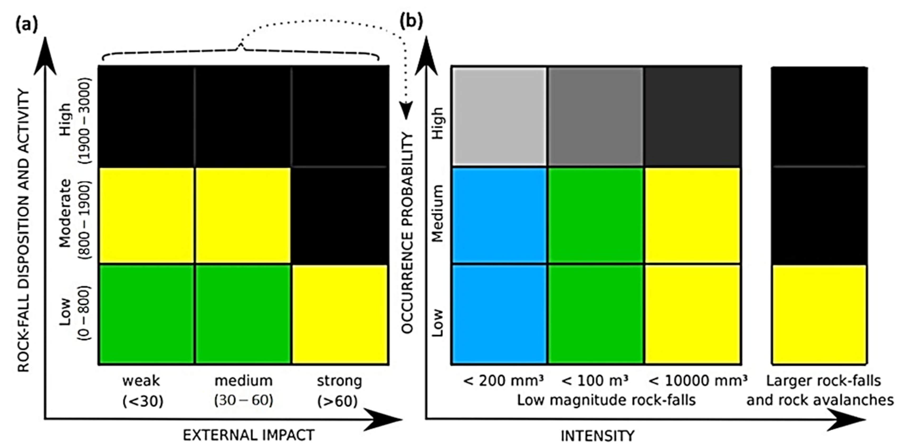
3.1. Bauer and Neumann Original Method
3.2. The Proposed Method
4. Results
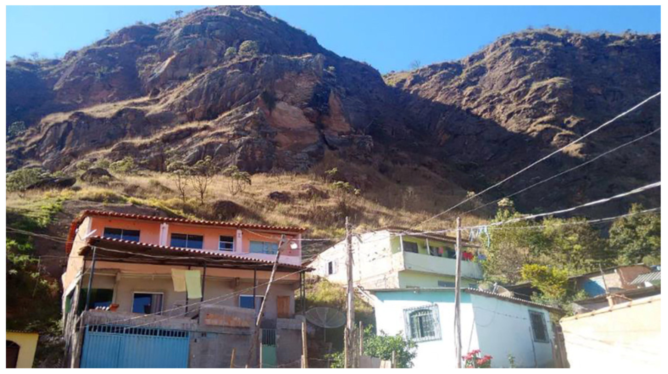
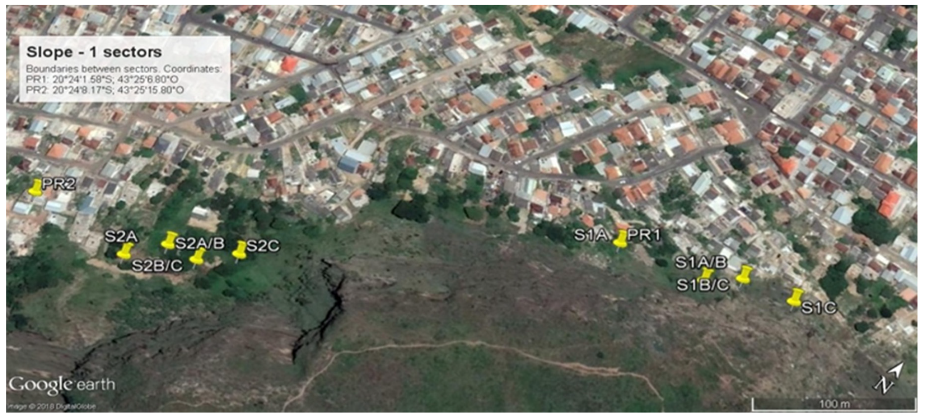
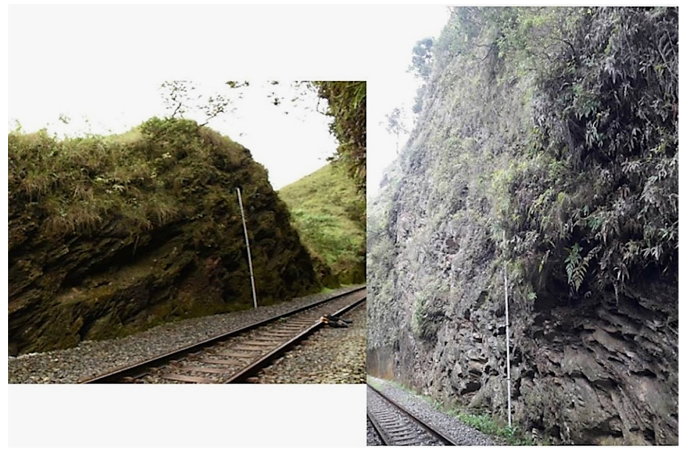
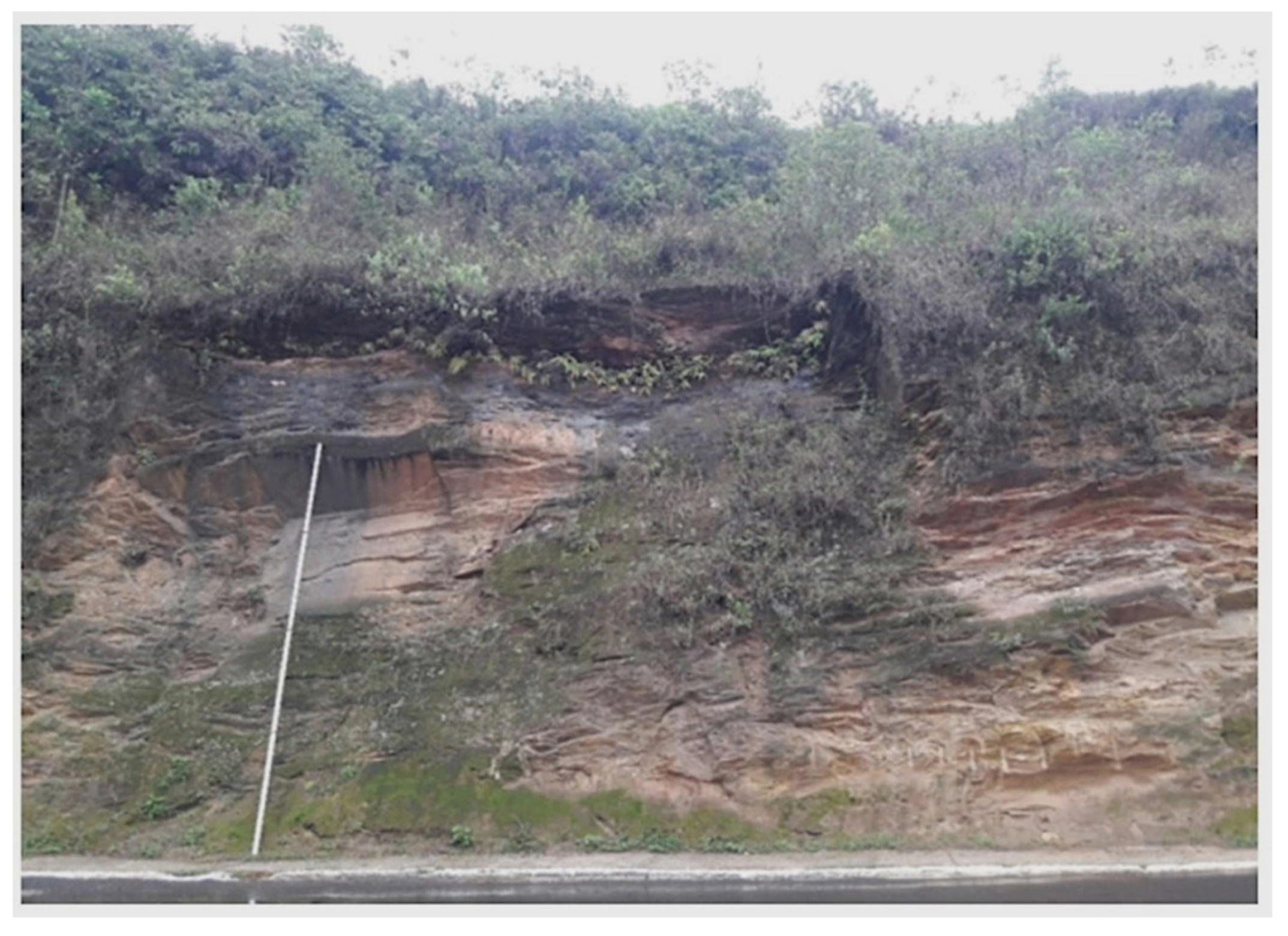
4.1. Characterization of Rock Masses—Slope-1
4.2. Characterization of Rock Masses—Slope-2
4.3. Characterization of Rock Masses—Slope-3
4.4. Rockfall Hazard Assessment
4.4.1. Bauer & Neumann Original Method
4.4.2. The New Proposal
5. Discussion
5.1. Comparison between Methods and General Comments
5.2. Validation of the Proposed Method
6. Conclusions
- The proposal is an easy to use and inexpensive method to evaluate rockfall hazards;
- Slope height, dip and the catchment area are incorporated in the proposal, which are parameters directly related to block path in a falling movement;
- Seismic effects are included in the proposal to evaluate the influence of traffic and blasting in rockfall assessment.
- Important results obtained by the method application are:
- The proposed method was applied successfully to a wide range of slope types, like urban, railway and mine slopes;
- The method proved to be efficient to quantify the most important factors affecting rockfalls.
Author Contributions
Funding
Data Availability Statement
Acknowledgments
Conflicts of Interest
References
- Luria, P.; Aspinall, P.A. Evaluating a multi-criteria method for hazard assessment in urban design. Environ. Impact Assess. Rev. 2003, 23, 625–653. [Google Scholar] [CrossRef]
- Lara, M.; Sepúlveda, S.A. Landslide susceptibility and hazard assessment in San Ramón Ravine, Santiago de Chile, from an engineering geological approach. Environ. Earth Sci. 2010, 60, 1227–1243. [Google Scholar]
- Filho, A.G. Risk analysis in the spillway of dam Orós by excess of influent flow. Ann. Braz. Acad. Sci. 2013, 85, 405–414. [Google Scholar]
- Lavrentyeva, G.V.; Mirzeabasov, O.A.; Synzynys, B.I. Ecological Risk Assessment for the Terrestrial Ecosystem under Chronic Radioactive Pollution. Int. J. Environ. Res. 2014, 8, 961–970. [Google Scholar]
- Martínez-Graña, A.M.; Goy, J.L.; Zazo, C. Water and Wind Erosion Risk in Natural Parks—A Case Study in “Las Batuecas–Sierra de Francia” and “Quilamas” Protected Parks (Central System, Spain). Int. J. Environ. Res. 2014, 8, 61–68. [Google Scholar]
- Mavrakis, A.; Salvati, L. Analyzing the Behaviour of Selected Risk Indexes During the 2007 Greek Forest Fires. Int. J. Environ. Res. 2015, 9, 831–840. [Google Scholar]
- Cerri, R.I.; Reis, F.A.G.V.; Gramani, M.F.; Giordano, L.C.; Zaine, J.E. Landslides Zonation Hazard: Relation between geological structures and landslides occurrence in hilly tropical regions of Brazil. Ann. Braz. Acad. Sci. 2017, 89, 2609–2623. [Google Scholar] [CrossRef] [Green Version]
- Bauer, M.; Neumann, P. A Guide to Processing Rock-Fall Hazard from Field Data. Geotechnical Safety and Risk. In Proceedings of the 3rd International Symposium on Geotechnical Safety and Risk, Munich, Germany, 1–4 June 2011; pp. 149–156. [Google Scholar]
- Fell, R.; Corominas, J.; Bonnard, C.; Cascini, L.; Leroi, E.; Savage, W.Z. Guidelines for landslide susceptibility, hazard and risk zoning for land use planning. Eng. Geol. 2008, 102, 85–98. [Google Scholar]
- Pierson, L.A.; Van Vickle, R. Rockfall Hazard Rating System. In Transportation Research Record 1343; National Research Board: Washington, DC, USA, 1993; pp. 6–19. [Google Scholar]
- Santi, P.M.; Russel, C.P.; Higgins, J.D.; Spriet, J.I. Modification and statistical analysis of the Colorado Rockfall Hazard Rating System. Eng. Geol. 2009, 104, 55–65. [Google Scholar] [CrossRef]
- McMillan, P.; Matheson, G.D. Rock slope hazard assessment: A new approach. Eng. Geol. Spec. Publ. 1998, 15, 177–183. [Google Scholar]
- Hermanns, R.L.; Oppikofer, T.; Anda, E.; Blikra, L.H.; Böhme, M.; Bunkholt, H.; Crosta, G.B.; Dahle, H.; Devoli, G.; Fischer, L.; et al. Hazard and Risk Classification for Large Unstable Rock Slopes In Norway. Ital. J. Eng. Geol. Environ. 2013, 6, 245–254. [Google Scholar]
- Delonca, A.; Verdel, T.; Gunzburger, Y. Influence of expertise on rockfall hazard assessment using empirical methods. Nat. Hazards Earth Syst. Sci. 2016, 16, 1657–1672. [Google Scholar] [CrossRef]
- Romana, M. New Adjustment Ratings for Application of Bieniawski Classification to Slopes; International Society of Rock Mechanics: Zacatecas, Mexico, 1985; pp. 49–53. [Google Scholar]
- Bieniawski, Z.T. Engineering Rock Mass Classifications: A Complete Manual for Engineers and Geologists in Mining, Civil, and Petroleum Engineering; John Wiley & Sons: New York, NY, USA, 1989; 251p. [Google Scholar]
- ISRM. Rock Characterization Testing and Monitoring; E.T. Brown: London, UK, 1981; 211p. [Google Scholar]
- Youssef, A.M.; Maerz, H. Development, justification, and verification of a rock fall hazard rating system. Bull. Eng. Geol. Environ. 2012, 71, 171–186. [Google Scholar]
- Silveira, L.R.C.; Cunha, L.E.; Hernández, P.A.; Lana, M.S.; Santos, T.B. Rockfall Hazard Rating System Adaptation Proposal for Urban Areas Through a Case Study In Mariana (MG, Brazil). In Proceedings of the 8th Brazilian Symposium of Rock (Cobramseg), Belo Horizonte, Brazil, 19–22 October 2016. [Google Scholar]
- Gomes, G.J.C.; Sobreira, F.G.; Lana, M.S. Evaluation of Rockfall Hazard Along Brazil Roads. Soils Rocks 2011, 34, 163–174. [Google Scholar]
- Ritchie, A.M. Evaluation of Rockfall and Its Control; U.S. Department of Commerce, Bureau of Public Roads, and the Washington State Highway Commission: Olympia, WA, USA, 1963.
- Silva, N.L. Correlação Entre Pluviosidade e Movimentos Gravitacionais de Massa no Alto Ribeirão do Carmo/MG. Master’s Thesis, Federal University of Ouro Preto, Ouro Preto, Brazil, 2014; p. 114p. [Google Scholar]
- Barton, N. Shear Strength Investigations for Surface Mining. In Stability in Surface Mining, Proceedings of 3rd International Conference (ed. CO Brawner), Vancouver, British Columbia, Society of Mining Engineers; AIME: New York, NY, USA, 1982; pp. 171–196. [Google Scholar]
- Santos, T.B.; Lana, M.S.; Santos, A.E.M.; Silveira, L.R.C. Applicability of geomechanical classifications for estimation of strength properties in Brazilian rock masses. Ann. Braz. Acad. Sci. 2017, 89, 859–872. [Google Scholar]
- Pereira, L.C. Análise Tensão-Deformação e por Equilíbrio-Limite do Mecanismo de Ruptura por Tombamento de Blocos. Master’s Thesis, Federal University of Ouro Preto, Ouro Preto, Brazil, 2012; p. 179p. [Google Scholar]
- Alvioli, M.; Santangelo, M.; Fiorucci, F.; Cardinali, M.; Marchesini, I.; Reichenbach, P.; Rossi, M.; Guzzetti, F.; Peruccacci, S. Rockfall susceptibility and network-ranked susceptibility along the Italian railway. Eng. Geol. 2021, 293, 106301. Available online: www.elsevier.com/locate/enggeo (accessed on 19 October 2021). [CrossRef]
- Budetta, P.; De Luca, C.; Nappi, M. Quantitative rockfall risk assessment for an important road by means of the rockfall risk management (RO.MA.) method. Bull. Eng. Geol. Environ. 2016, 75, 1377–1397. [Google Scholar] [CrossRef]


| Susceptibility (Disposition + activity) | Rock Mechanics (Disposition) | Parameter | Value | ||
| Unfavorable | Fair | Favorable | |||
| (1) Discontinuity orientation | 500 (Adverse or slope parallel) | 200 (horizontal) | 0 (Vertical or inward) | ||
| (2) Weathering | 200 (W4–W5) | - | 0 (W1–W3) | ||
| (3a) Discontinuity extent | 200 (>10 m) | 100 (1–10 m) | 0 (<1 m) | ||
| (3b) Degree of transection of discontinuities | 200 (No mineral bonds) | - | 0 (Mineral bonds existent) | ||
| (3c) Discontinuity aperture | 200 (>1 cm) | 100 (0.5–1 cm) | 0 (<0.5 cm) | ||
| (3d) Discontinuity roughness | 200 (Slickensides) | - | 0 (No slickensides) | ||
| (4) Degree of loosening (alternative to category 3) | 800 (Clear indications available) | 400 (Only subordinate indications) | 0 (No indications) | ||
| Geomechanical Environment (Disposition) | (5) Type of basement | 600 (Dissolvable rocks) | 200 (Clayey—marly formations) | 0 (Other formations) | |
| (6) Large-scale, deep-seated deformations | 200 (yes) | - | 0 (no) | ||
| (7) Mass movements in the slope foot | 200 (yes) | - | 0 (no) | ||
| (8) Activity | Initial Activity | 500 (Active) | - | 0 (Not active) | |
| Total Susceptibility (1 + 2 + (3 or 4) + 5 + 6 + 7 + 8) | |||||
| External Impact | (9) Precipitation | 50 (>310 mm) | 20 (230–310 mm) | 0 (<230 mm) | |
| (10) Earthquakes | 50 (Zone 2) | 20 (Zone 1) | 0 (Zone 0) | ||
| Total External Impact (9 + 10) | |||||
| Intensity | High Magnitude Rockfalls | Low Magnitude Rockfalls | |||
| Volume | Rock avalanche | Large rockfalls | Medium rockfalls | Small rockfalls | Single Blocks |
| Distinction | Total volume > 1,000,000 m3 | Total volume close to 1,000,000 m3 | Total volume close to 10,000 m3 | Total volume approximately 100 m3 or fragments with more than 200 mm diameter | One or few single fragments < 200 mm diameter |
| Slope Dip and Surface | Rough SlopeDip 30°–75° | Vertical Slope with Roughness and Overhangs | Vertical Slope, without Roughness and Overhangs |
|---|---|---|---|
| Score | 200 | 100 | 0 |
| Catchment area | No area; or area with low distance and high inclination. No vegetation. | Moderate distance and inclination. Low or no vegetation. | Larger distance, plane. Or an adequately designed catchment area, like in highways. |
| Score | 200 | 100 | 0 |
| External impact | Unfavorable | Fair | Favorable |
| Precipitation range (mm/days) | >129/6 | 40–129/6 | <40/6 |
| Score | 50 | 20 | 0 |
| Seismic effects | High seismic zone or damage due to blasting in mines | karst regions, blasting in mines or heavy vehicles and/or medium seismic zone traffic | No seismic effects |
| Score | 50 | 20 | 0 |
| Parameters | Unit | Measurement/Classification | |
|---|---|---|---|
| Uniaxial Compressive Strength (UCS) | MPa | Geological Hammer/ ISRM Classification [17] | |
| Weathering Degree | - | ISRM Classification [17] | |
| Discontinuities | Orientation | Dip/Dip Direction | Brunton Compass |
| Spacing | Metric System | Tape | |
| Length | Metric System | Tape | |
| Roughness | - | Barton [23] | |
| Aperture | Metric System | Tape | |
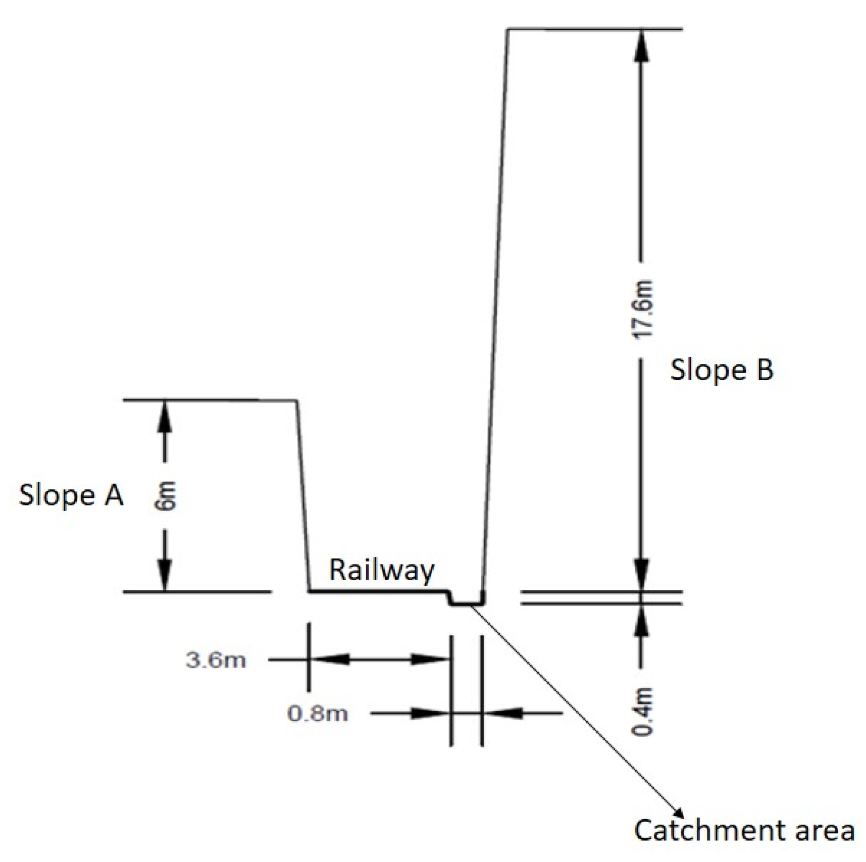
| Slope and catchment area | Height and inclination | Metric System | Tape and Laser Tape |
| Block dimension | Metric System | Tape | |
| Vegetation | - | - | |
| Sector | H (m) | ψs (°) | Length (m) |
|---|---|---|---|
| S1A | 55 | 75 | 60 |
| S1B | 30 | 68 | 25 |
| S1C | 29 | 57 | 35 |
| S2A | 80 | 60 from the top to 34.5 m 69 from 34.5 m to the base | 30 |
| S2B | 59 | 72 | 17 |
| S2C | 78 | 73 | 28 |
| Sector | ψca (°) | D (m) | Characteristics |
|---|---|---|---|
| 1A | 18 | 24 | Soil and grass. |
| 1B | 15 | 17 | Soil, grass and some blocks. |
| 1C | 41 | 9 | Soil, debris and blocks. |
| 2A | 25 (talus cover); 13 (pasture). | 20 (talus cover); 18 (pasture). | Talus cover: small trees, soil, debris and blocks. Pasture: soil and grass. |
| 2B | 25 | 45 | Soil and grass |
| 2C | 11 | 50 | Soil and grass |
| Area | Set | Dip/Dip Direction (°) | Spacing (m) | Trace Length (m) | Roughness |
|---|---|---|---|---|---|
| PR1 | Set 1 (foliation) | 21/139 | 0.42 | 20 | Rough, planar |
| Set 2 | 60/338 | 1.43 | 3 | Rough, undulating | |
| Set 3 | 62/038 | 0.76 | 3 | Rough, undulating | |
| Slope Face | 67/317 | - | - | ||
| PR2 | Set 1 (foliation) | 27/117 | 0.24 | 20 | Rough, planar |
| Set 2 | 82/339 | 0.44 | 3 | Rough, undulating | |
| Set 3 | 55/280 | 0.76 | 3 | Rough, undulating | |
| Slope Face | 70/318 | - | - |
| Sector | Aperture (cm) | Filling | Weathering (ISRM 1981) | Strength (ISRM 1981) |
|---|---|---|---|---|
| S1A | Closed | None | W1 | R5 |
| S1B | 1–5 | Soft sand | W2 | R4 |
| S1C | 1–10 | Soft sand | W2 | R4 |
| S2A | Closed | None | W1 | R5 |
| S2B | Closed | None | W1 | R5 |
| S2C | 1–5 | Soft sand | W1 | R4 |
| Set | Dip/Dip Direction (°) | Spacing (m) | Trace Length (m) | Roughness |
|---|---|---|---|---|
| Set 1 | 37/194 | 0.25 | 15 | Smooth |
| Set 2 | 44/139 | 0.42 | 10 | Slightly rough |
| Set 3 | 48/040 | 0.38 | 10 | Slightly rough |
| Slope A | 87/075 | - | - | - |
| Slope B | 88/259 | - | - | - |
| Set | Dip/Dip Direction (°) | Spacing (m) | Trace Length (m) | Roughness |
|---|---|---|---|---|
| Set 1 | 43/211 | 0.24 | 3–10 | Slightly rough |
| Set 2 | 79/298 | 0.57 | 1–3 | Slightly rough |
| Set 3 | 46/044 | 0.36 | 1–3 | Slightly rough |
| Slope | 76/040 | - | - | - |
| Slope | Susceptibility | Maximum/Minimum Rainfall | Seismic Effects | Maximum/Minimum Rockfall Probability | Intensity | Hazard |
|---|---|---|---|---|---|---|
| S1A | 1400 | 50/0 | 0 | Medium/Medium | Up to 200 mm | Low |
| S1B | 1600 | 50/0 | 0 | Medium/Medium | Up to 200 mm | Low |
| S1C | 1600 | 50/0 | 0 | Medium/Medium | Up to 200 mm | Low |
| S2A | 1400 | 50/0 | 0 | Medium/Medium | Up to 200 mm | Low |
| S2B | 1400 | 50/0 | 0 | Medium/Medium | Up to 200 mm | Low |
| S2C | 1600 | 50/0 | 0 | Medium/Medium | Up to 200 mm | Low |
| Slope-2 A | 900 | 50/0 | 0 | Medium/Medium | Up to 200 mm | Low |
| Slope-2 B | 900 | 50/0 | 0 | Medium/Medium | Up to 200 mm | Low |
| Slope-3 | 1700 | 50/0 | 0 | Medium/Medium | Up to 200 mm | Low |
| Slope | Susceptibility | Maximum /Minimum Rainfall | Seismic Effects | Maximum/Minimum RockfallProbability | Intensity | Maximum/Minimum Hazard |
|---|---|---|---|---|---|---|
| S1A | 1781 | 50/0 | 0 | Medium/Medium | Up to 200 mm | Low |
| S1B | 2011 | 50/0 | 0 | High/High | Up to 200 mm | High |
| S1C | 2010 | 50/0 | 0 | High/High | Up to 200 mm | High |
| S2A | 2200 | 50/0 | 0 | High/High | Up to 200 mm | High |
| S2B | 1719 | 50/0 | 0 | Medium/Medium | Up to 200 mm | Low |
| S2C | 2311 | 50/0 | 0 | High/High | Up to 200 mm | High |
| Slope-2 A | 1102 | 50/0 | 20 | High/Medium | Up to 200 mm | High/Very Low |
| Slope-2 B | 1104 | 50/0 | 20 | High/Medium | Up to 200 mm | High/Very Low |
| Slope-3 | 1902 | 50/0 | 0 | High/High | Up to 200 mm | High |
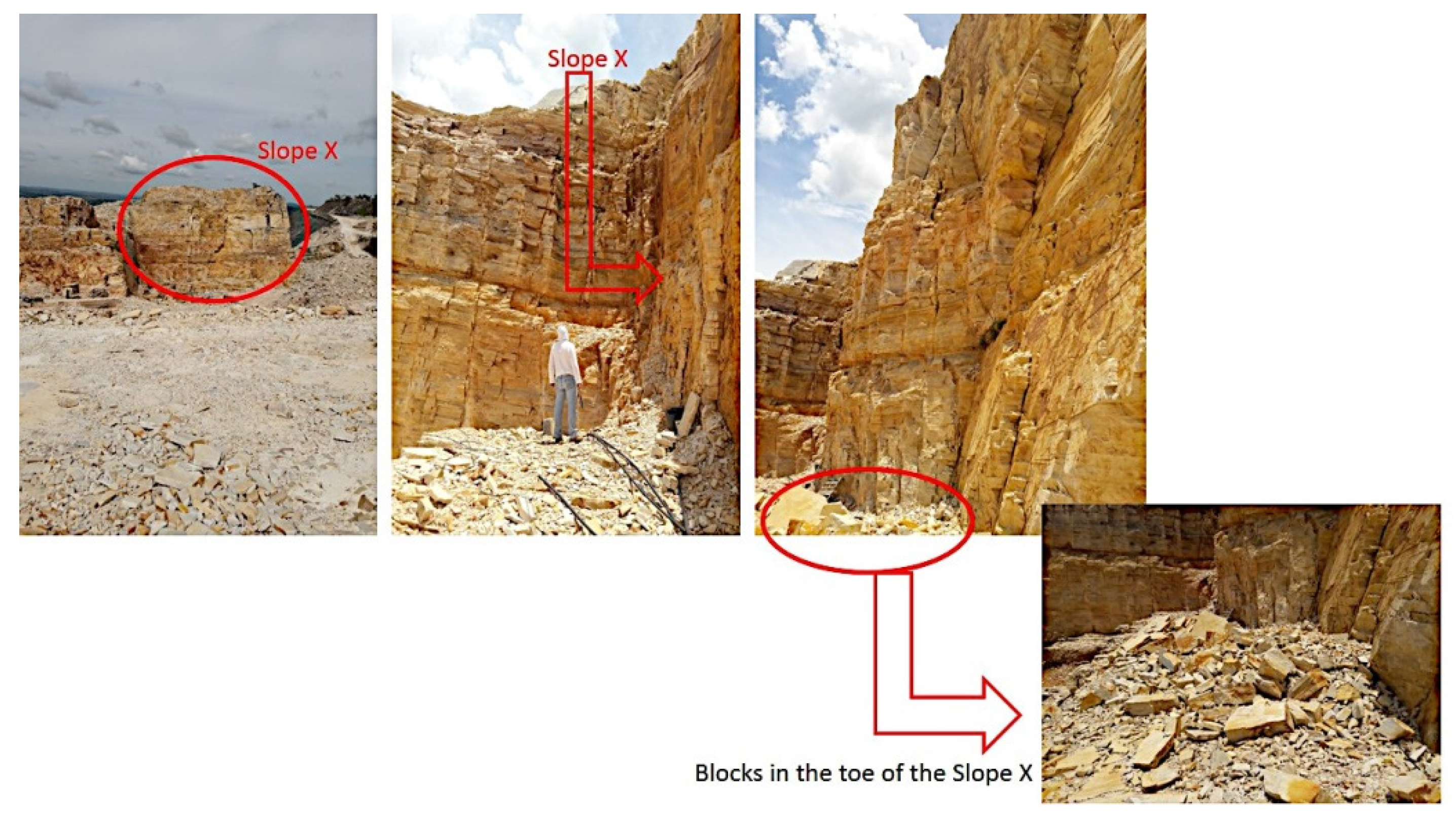
| Slope | Susceptibility | Maximum/Minimum Rainfall | Seismic Effects | Maximum/Minimum Rockfall Probability | Intensity | Hazard |
|---|---|---|---|---|---|---|
| X | 2003.8 | 50/0 | 20 | High/High | Up to 200 mm | High |
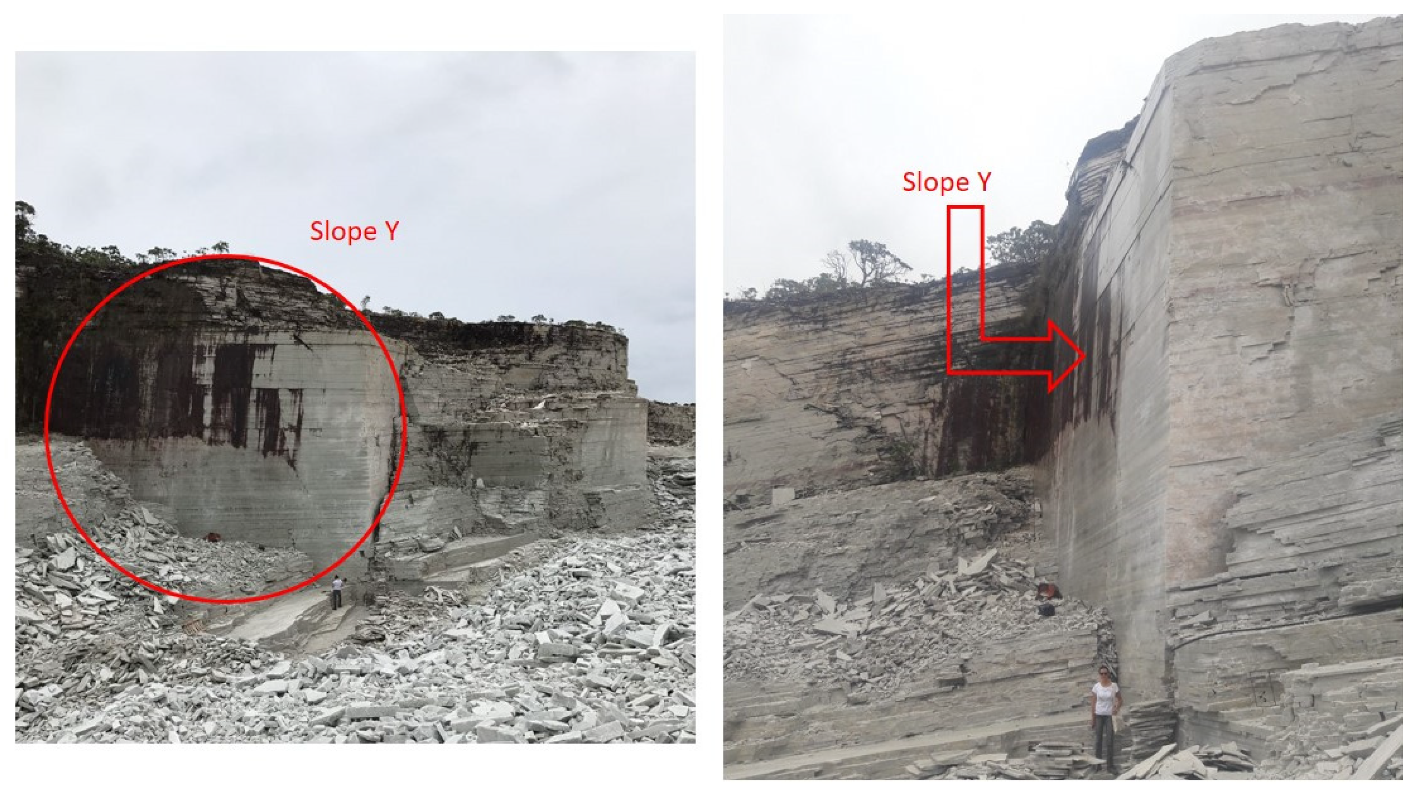
| Y | 702.2 | 50/0 | 20 | Low/Low | Up to 200 mm | Low |
Publisher’s Note: MDPI stays neutral with regard to jurisdictional claims in published maps and institutional affiliations. |
© 2022 by the authors. Licensee MDPI, Basel, Switzerland. This article is an open access article distributed under the terms and conditions of the Creative Commons Attribution (CC BY) license (https://creativecommons.org/licenses/by/4.0/).
Share and Cite
Silveira, L.R.C.; Lana, M.S.; Alameda-Hernández, P.; dos Santos, T.B. A New Methodology for Rockfall Hazard Assessment in Rocky Slopes. Mining 2022, 2, 791-808. https://doi.org/10.3390/mining2040044
Silveira LRC, Lana MS, Alameda-Hernández P, dos Santos TB. A New Methodology for Rockfall Hazard Assessment in Rocky Slopes. Mining. 2022; 2(4):791-808. https://doi.org/10.3390/mining2040044
Chicago/Turabian StyleSilveira, Larissa Regina Costa, Milene Sabino Lana, Pedro Alameda-Hernández, and Tatiana Barreto dos Santos. 2022. "A New Methodology for Rockfall Hazard Assessment in Rocky Slopes" Mining 2, no. 4: 791-808. https://doi.org/10.3390/mining2040044