
Digitising Legacy Field Survey Data: A Methodological Approach Based on Student Internships

Groningen Institute of Archaeology, University of Groningen, 9712 ER Groningen, The Netherlands
Digital 2022, 2(4), 422-443; https://doi.org/10.3390/digital2040023
Submission received: 15 August 2022
/
Revised: 12 September 2022
/
Accepted: 13 September 2022
/
Published: 22 September 2022
(This article belongs to the Special Issue Bridging Digital Approaches and Legacy in Archaeology)
Abstract
:In the Mediterranean, field survey has been the most widely used method to detect archaeological sites in arable fields since the 1970s. Through survey, data about the state of preservation of ancient settlements have been extensively mapped by archaeologists over large rural landscapes using paper media (e.g., topographical maps) or GPS and GIS technologies. These legacy data are unique and irreplaceable for heritage management in landscape planning, territorial monitoring of cultural resources, and spatial data analysis to study past settlement patterns in academic research (especially in landscape archaeology). However, legacy data are at risk due to often improper digital curation and the dramatic land transformation that is affecting several regions. To access this vast knowledge production and allow for its dissemination, this paper presents a method based on student internships in data digitisation to review, digitise, and integrate archaeological primary survey data. A pilot study for Central–Southern Italy and the Iberian Peninsula exemplifies how the method works in practice. It is concluded that there are clear benefits for cultural resource management, academic research, and the students themselves. This method can thus help us to achieve large-scale collection, digitisation, integration, accessibility, and reuse of field survey datasets, as well as compare survey data on a supranational scale.
1. Introduction
The rural landscape is a very vulnerable type of cultural heritage [1]. The traces impressed by past human dwellings on the natural environment are fragile evidence of the ability and intellectual creativity of their former builders. Relicts of settlements, field systems, and other infrastructures (e.g., roads, channels) can be detected while walking in the field through survey. These sites provide important data about the communities living in the countryside over time and their endeavours to adapt to new challenges and exploit the land for survival and growth. The Mediterranean area is exceptionally rich in agrarian landscapes with archaeological sites, but several are at risk of destruction by natural processes, climate change, or human transformations through development, combined with other threats, such as the destruction of sites by environmental disasters and wars [2,3,4,5]. In this paper, a methodological solution is presented to unlock the power of legacy survey data for archaeological research and heritage management in landscape planning. The method presented is based on student internships for the digitisation of primary field survey data and is demonstrated with two practical case studies in Central–Southern Italy and the Iberian Peninsula.
The field survey conducted consists of walking in large rural regions, usually in teams following regular lines [6,7,8,9] (Figure 1). By observing the soil surface, archaeologists can detect ruins or concentrations of artefacts, the remains of walls or floors that have surfaced by ploughing, and/or erosion from (buried) archaeological sites. These finds are a sound indicator of the presence of archaeological heritage located underneath or in the surroundings of their discovery. Since the 1970s, data about the state of preservation of ancient settlements have been massively mapped by archaeologists during field surveys over large rural landscapes in the Mediterranean [10,11]. These raw data are important for both territorial monitoring of cultural resources in heritage management (by showing where archaeological remains are located, the future impact of landscape changes to sites can be better anticipated, managed, and guided [12,13,14,15,16,17,18,19]) and landscape archaeology (these data underpin ancient settlement patterns and can be used in regional analyses of large-scale/long-term cultural phenomena, such as colonisation, migration, land-use, environmental changes, and economic production (e.g., Refs. [20,21,22,23,24,25,26,27,28,29,30,31,32,33,34,35,36,37]; for an overview of Mediterranean surveys: Ref. [11]).
The dramatic soil consumption affecting the Mediterranean in recent decades (e.g., Ref. [38]) has called for action to map ancient ruins to preserve archaeological sites at least by record before it is too late (see the discussion on anthropogenic impact to rural landscapes in Refs. [39,40]). The growing urbanisation and use of mechanized intensive agriculture in recent decades have had detrimental effects on both heritage management and landscape archaeology. First, field surveyors have attempted to map as many archaeological remains/sites as possible before (or while) sites being destroyed or damaged by tractors, bulldozers, deep-ploughing, and construction works [10,41,42,43]. This rescue operation has yielded unique information about the location and characteristics of buried sites, which is vital for territorial monitoring of archaeological resources in planning sustainable landscape developments [44,45]. Second, this call for action has activated a flourishing and still-ongoing season of methodological experiments of field survey techniques for landscape archaeology specifically tailored to the investigation of ancient Mediterranean occupation patterns [8,9,11].
The method presented in this paper does not try to halt landscape changes. Instead, it supports adaptable, context-specific landscape planning and management strategies for cultural heritage through the use of survey data [46]. More precisely, this method allows access to and sharing of (legacy) survey data, with special attention to those originally collected in regions that have witnessed drastic transformations in recent decades. Considering the extent of destruction that has recently occurred in several regions, these data are likely the best and only data available to study past settlement patterns in historical research. Primary legacy data of previous now-transformed landscapes offer a touchstone for the assessment of archaeological loss that other Mediterranean landscapes could soon be facing, thus providing strategic foresight for future heritage management and landscape planning [16,47,48,49].
Moreover, the method presented here may boost a new wave of field-survey campaigns targeting the preserved marginal landscapes of the Mediterranean for the collection of fresh data that may help to anticipate future scenarios in heritage management, thus stimulating critical thinking about change, emerging opportunities, and challenges. In places with little urbanisation and intense farming, archaeologists can produce digital reports and GIS maps that anticipate the opportunities, risks, and impacts of future transformation or preservation decisions for heritage practitioners (e.g., ministries of culture and environment, UNESCO, ICCROM, FAO) by performing systematic (re-)surveys on a large scale. This is timely considering the fast deterioration of the surface archaeological record and will be beneficial for academic research (i.e., new data and analyses), not to mention the contribution to the scholarly discussion questioning legacy data produced by “old-fashioned” field-survey techniques against the allegedly more reliable data registered by present-day intensive field-survey methods (cf., discussion in Refs. [50,51]).
2. How to Unlock Legacy Survey Data
The method presented in this section is based on student internships in the digital humanities and aims to unlock the primary, first-hand legacy survey data (from source published material and grey reports) for research purposes and heritage management in landscape planning. Field survey is defined as fieldwalking by archaeologists to locate material concentrations and structures belonging to archaeological sites. Legacy survey data consist of maps and catalogues of finds and site characteristics registered in the field by archaeologists using paper media (e.g., topographic prints, notebooks) or, in recent decades, GPS and GIS digital technologies [52].
There exists an enormous and variegated amount of legacy survey data, but they are very difficult to access [53]. The open data movement is gaining followers in archaeology but, contrary to other domains, has not yet succeeded in breaking through [54]. This and the time required to render datasets into the right digital shape for deposition prevent the sharing of the original information; hence, access is still very limited. Moreover, a large amount of data was recorded decades ago using obsolete media formats (e.g., floppy disks, internal drives of old computers) or using vendor-specific software with old, discontinued versions and thus will be unreadable in the near future. As scholars retire or pass away, the knowledge of where these data are stored (and how) is potentially lost. Often, the only memory of these data is the final publication produced by the survey team (i.e., published reports, articles, or books), which often presents only a stark reduction of the original information.
However, another problem is in regard to the dispersion of the final publications. Except for the most famous survey projects, which can be easily found in several (digital) libraries, the publications of survey results are often only kept locally, in the local archives or libraries of the territory/region where the fieldwork was conducted or at the university/institute that sponsored it or has an interest in the investigated area. Visits to local libraries are necessary to access, scan, or acquire these source publications. For economic or time-related reasons, this is not always possible: for example, the COVID-19 pandemic posed restrictions on travelling abroad for more than two years and limited the mobility of researchers; therefore, visits to local libraries, archives, and museums for data collection had to be postponed.
Sometimes, survey result publications and grey reports may be dispersed throughout the Academia.edu or ResearchGate profiles of field directors or can be found through intense web browsing. The fallback option is to ask for the publication directly by contacting the data producer (field director). However, success is not guaranteed, and, even when the article, book, or report is obtained, the information remains locked within the published form. Only digitisation can make these data machine-readable and thus usable. Converting data with GIS digitisation into sustainable, long-lived digital formats can enable the processing, display, dissemination, interoperability, reuse, and comparison of knowledge for current and future large-scale analyses (see discussion in Ref. [10]), thus breathing new life into “old” data.
In times of crisis dictated by the problems listed above, we tried to absorb these adversities and find a resilient solution to cope with them. These challenges triggered the implementation of a novel collaborative method to ease access to these important legacy data. This method is grounded in the nichesourcing principle [55,56]. As with crowdsourcing, it is a means to collect large data using the internet and handle high digitisation workloads with the help of interested communities. In nichesourcing, however, only groups of domain experts are involved (e.g., researchers, professionals, or graduate students), whereas crowdsourcing usually entails the participation of amateurs and volunteers from the general public as well. Crowdsourcing can be successfully employed for simple annotations or digitisations. However, for solving knowledge-intensive tasks (e.g., complex descriptions of metadata, geospatial analysis) that require a significant level of expertise (e.g., knowledge of domain terminologies and issues, specific digital skills), it may be more efficient to outsource these tasks to a niche community of experienced, motivated contributors [57]. It is important to highlight that, different from crowdsourcing, nichesourcing projects are not aimed at public engagement but rather at obtaining high-quality contributions to be handed over to other students, scholars, or heritage professionals for their scientific and social research.
Online international internships in the digital humanities for university students are a nichesourcing solution for the collection and digitisation of archaeological legacy survey data. As exemplified below, it works well in times of crisis because it is a resilient education formula that has been adapted to train students in the face of pandemics [58,59]. Students and their supervisors, with good background knowledge and command of GIS and digital archaeological data archiving, form a powerful crowd for the task of unlocking legacy survey data. Acquiring transferable skills for their future career and credits for their degree (ECTS) is what intrinsically motivates students to pursue an internship. In the internship presented below, students expanded their experience in digital archaeology, GIS, semantic ontology, and comparative data analysis, all of which are important skills for an archaeologist. They also engaged in collaborative research with an international team and with what constitutes good practice around open data publication, citation, and reuse [60,61,62,63]. Generally, this education gain and the monetary incentives (e.g., cost reimbursement for book scans and travels to local libraries, or a volunteer allowance) or rewards (e.g., sponsored study trips, certificates, and recognition on social media platforms or publications) ensured student commitment for the entire internship duration.
In practice, teams of selected graduate students in archaeology at a master or PhD level, from different countries and universities, are remotely supervised by professionals (e.g., postdoc researchers or professors). Through distance mentoring, they learn to collaborate in searching, collecting, and digitising in databases and in GIS the data/metadata stored in publications of previous survey projects. The final result of their digitisations can be defined as converted legacy survey data. To produce digitally converted data, students engage in seven internship phases:
- Phase one focuses on knowledge acquisition, updating or upgrading skills through supervisor guidance, and self-study of the relevant bibliography, also by means of online tutorials. Depending on the student level, this phase allows the transfer or consolidation of specific expert knowledge to the student niche; students, however, should already have familiarity with the subject and be skilled in performing specific digital tasks; otherwise, there is a risk that the work of the supervisor (who also has other job duties and can reserve only limited time to teaching for the internships) becomes too demanding and time-consuming.
- The identification of survey projects and bibliographic references of survey project publications by studying relevant literature and surfing the web.
- The collection or acquisition of publications online and in local libraries located in the students’ home country/university, which should be easily reachable with public transport.
- Description of the methodology and terminologies of the survey projects using standardized forms. If the information on survey design and recording method is not stated in the publications or is only partially disclosed, reflection and source criticism are performed by the students guided by the supervisor to extract such information whenever possible. This is essential to allow future comparison of datasets.
- The georeferencing of raster maps; the importation of spatial coordinates; the digitisation as vector files in GIS of the research area, the surveyed units (if available; e.g., graphic representations of the fields/agricultural parcels walked during the survey that have been investigated), and site locations; and the systematisation in digital spreadsheets of the chronological and typological information for the respective attribute tables (e.g., types and periods of occupation for sites, from Prehistory onwards; the descriptions of collected material; the visibility conditions, sampling method/coverage percentage for surveyed units). This allows data interoperability and querying of the data in GIS for regional pattern analysis.
- The annotation of metadata in standardized forms reporting indications and descriptions of the procedures used by the students for the manipulation of the original legacy data during the creation of the digitally converted legacy data. This phase safeguards the long-term re-usability of the datasets for future research.
- The deposition of these converted legacy survey data (and metadata) in online open access WebGIS platforms/repositories, with proper citation of the source and the original data, and with permalinks. This safeguards both the long-term availability and re-usability of these datasets for future research.
2.1. The Pilot Study
A pilot study is presented in this section to show how the proposed method works in practice and to test its efficiency for wider applications. This pilot study regards the legacy data of previous field walking surveys in Central–Southern Italy and in the Iberian Peninsula (especially in Portugal) and was conducted mostly online (with short stays at the KNIR institute in Rome) from 2020 until 2022 during three yearly internship editions, for about eight months in total. The internship title is “Digital Field Survey Archaeology”; the past three editions were supported by the KNIR-Royal Netherlands Institute in Rome, Leiden University, and the University of Groningen, and sponsored by the Prins Bernhard Cultuurfonds as part of a larger research project (PI Dr. Tesse D. Stek) whose goal is twofold [64]: first, to guarantee digital preservation and accessibility of survey datasets in the Western Mediterranean; second, to use these datasets for studying rural settlement patterns in relation to the Roman expansion in Italy, Portugal, and Spain. By comparing these patterns in a Western Mediterranean perspective, differences and similarities in settlement strategies and land-use organisation can be identified, thus shedding light on the interactions between Iron Age communities and the early rise and expansion of Rome in the West.
After a selective procedure based on the curriculum vitae and motivation, eleven master- and PhD-level students from Dutch, Italian, and Portuguese universities were recruited as our nichesourcing members. They worked in teams of two to three members and were supervised by the postdoc researcher within the project (the author). The internships focused on two levels: one was urgency, which involved the targeting of survey projects by giving priority to those in highly deteriorated landscapes (cf., Section 1); the other was the project research interest, the investigation of rural settlement patterns in the countryside around early Roman towns in Italy, Portugal, and Spain, and their relation to local pre-existent systems in the period between the 4th and 1st century BC. These two factors determined the selection of case studies (i.e., survey projects). For the data sharing between project members and data archiving during the internship, we used Google Drive, specifically a shared folder with subfolders organised in a standard way for each case study. Online meetings and remote teamwork were conducted via Google Meet. Moreover, the KNIR offered students the possibility to spend three weeks together at the institute in Rome to discuss their work in person and present it to the KNIR community. The software used for data digitisation was the QGIS and the Office suite.
Teamwork and collaborative spirit were essential factors for the success of these internships, as well as the ability of the students to work autonomously, creatively, and approach problems critically. The working schedule was flexible and working part-time was possible. The interns defined their working schedules independently but were asked to be available for online group work and weekly meetings. After a trial period, it became clear what each student performed best. Some students were more skilled in literary research in libraries; others had a technical attitude in solving practical digital issues, for instance, with QGIS or Excel databases. However, to enhance international cross-fertilisation between different expertise and scholarships, we realised that the best strategy for task division consisted in assigning case studies to each team rather than to each team member. This activated synergies between students and teams, who became familiar with discussing how to approach tasks together and taught one another how to tackle issues according to their own experience. Moreover, this approach permitted them to confront the research agendas of their home universities and acknowledge similarities as well as divergences in national field traditions and methodologies.
This internship formula educates the future generation of archaeologists to be responsible with their field data, describe data precisely, and make data openly available whenever possible. Student interns became passionate about the questions dealt with during the internships because they became aware of the urgency, the need, and the importance of safeguarding legacy survey data with their digitisations. They also developed an altruistic attitude, namely that they felt they were doing something good for the benefit of other researchers and students, and perceived their work as a mission to help future historical studies in the service of current research agendas. Student interns learned that attention must be paid to future data comparability just as much as data sharing: poor documentation on data creation may hamper the use of survey datasets and limit their potential uses for future analysis. It is likely that, if these student interns became field directors in the future, they would consider data stewardship and responsible preservation as essential components of good research practice in their survey projects and would think reflexively about how their methodologies and terminologies could impact future usage of their survey data. As the researchers of the future, they can put this pilot’s methods into natural practice and further disseminate this knowledge.
Results of the Pilot Study
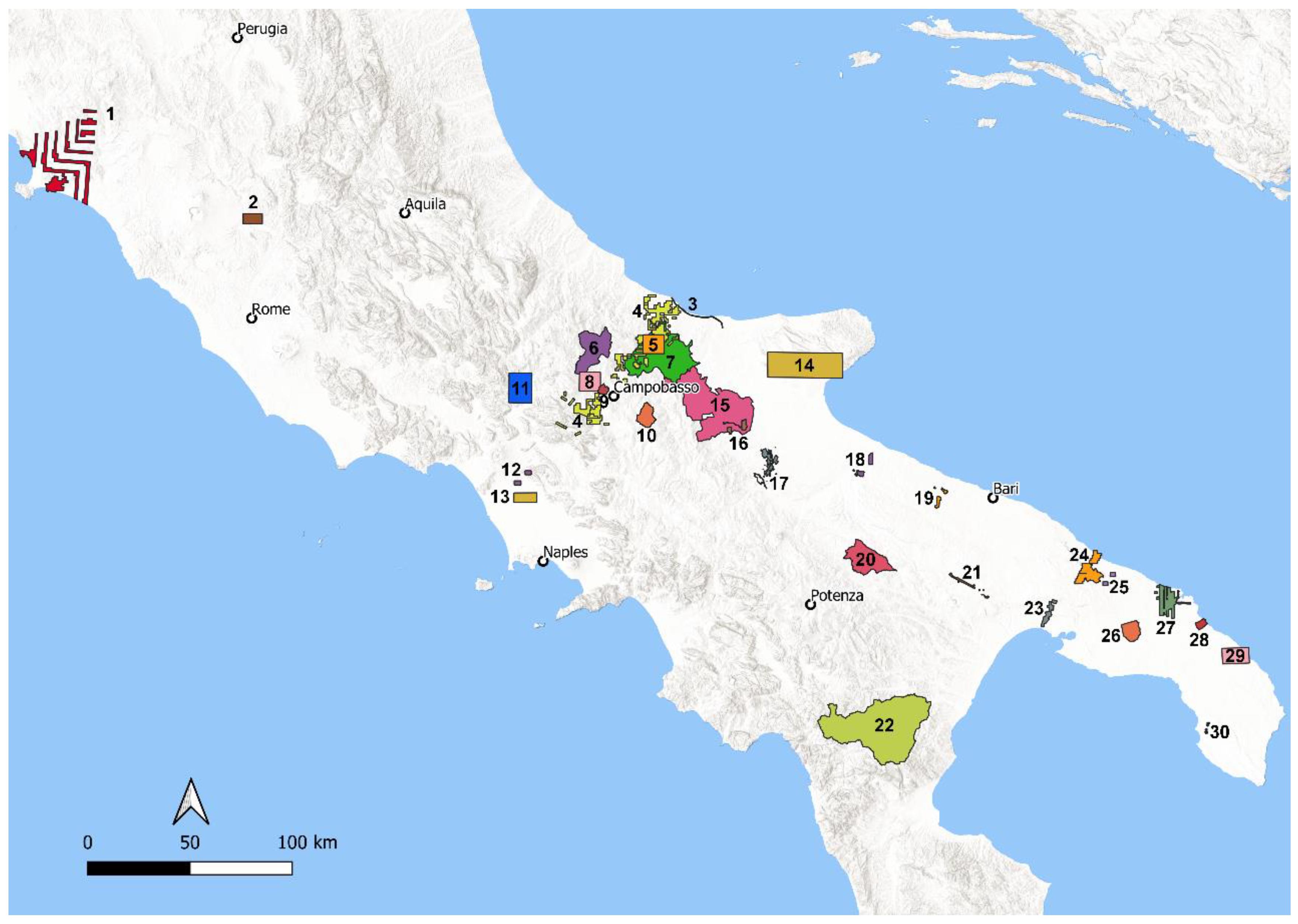
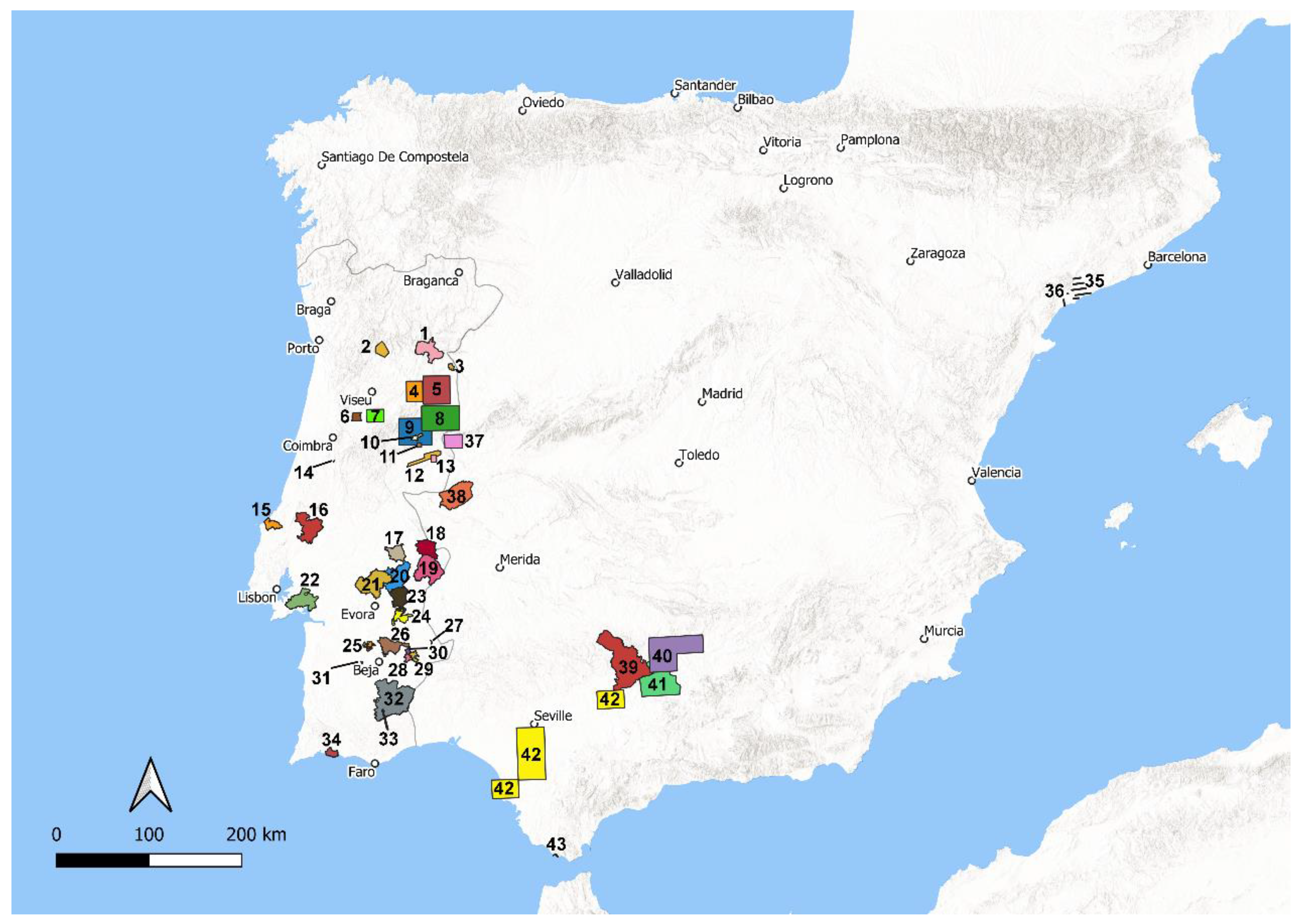
Following the stages described in Section 2, our students were able to collect and digitise the information of 73 survey projects corresponding to ca. 2,350,356 ha of Mediterranean territory; 30 of these survey projects were for Italy (413,023 ha of territory and 8342 sites), and 43 for the Iberian Peninsula (respectively 34 for Portugal and 9 for Spain, corresponding to 1,937,333 ha of territory and 5787 sites) (for more details, see Table A1 and Table A2 in Appendix A and Figure 2 and Figure 3). This results in an average of 0.6 archaeological sites per sq. km when the extent of all research areas is considered, or 2 and 0.3 sites per sq. km when the extent of the Italian and Iberian research areas are considered, respectively. Some human errors in student digitisations are to be expected; nevertheless, the discrepancy in site density between countries is interesting, especially if we compare the overall data of each region from a large-scale Western Mediterranean perspective. This divergent site density may reflect a real difference in archaeological potential between countries, the fact that more systematic intensive field surveys have been conducted in Central–Southern Italy than in the Iberian Peninsula (especially in Portugal where non-systematic extensive explorations are abundant (cf. Ref. [11])), the variable landscape morphologies and visibility conditions covered by these surveys, or a combination of these factors. More research into this aspect is necessary to assess how different methodologies or landscape geomorphologies may affect the number of discovered sites in the surveys analysed during our internships and how possible research biases may alter our perception of the heritage potential of a given region or country [65,66,67,68,69,70,71].
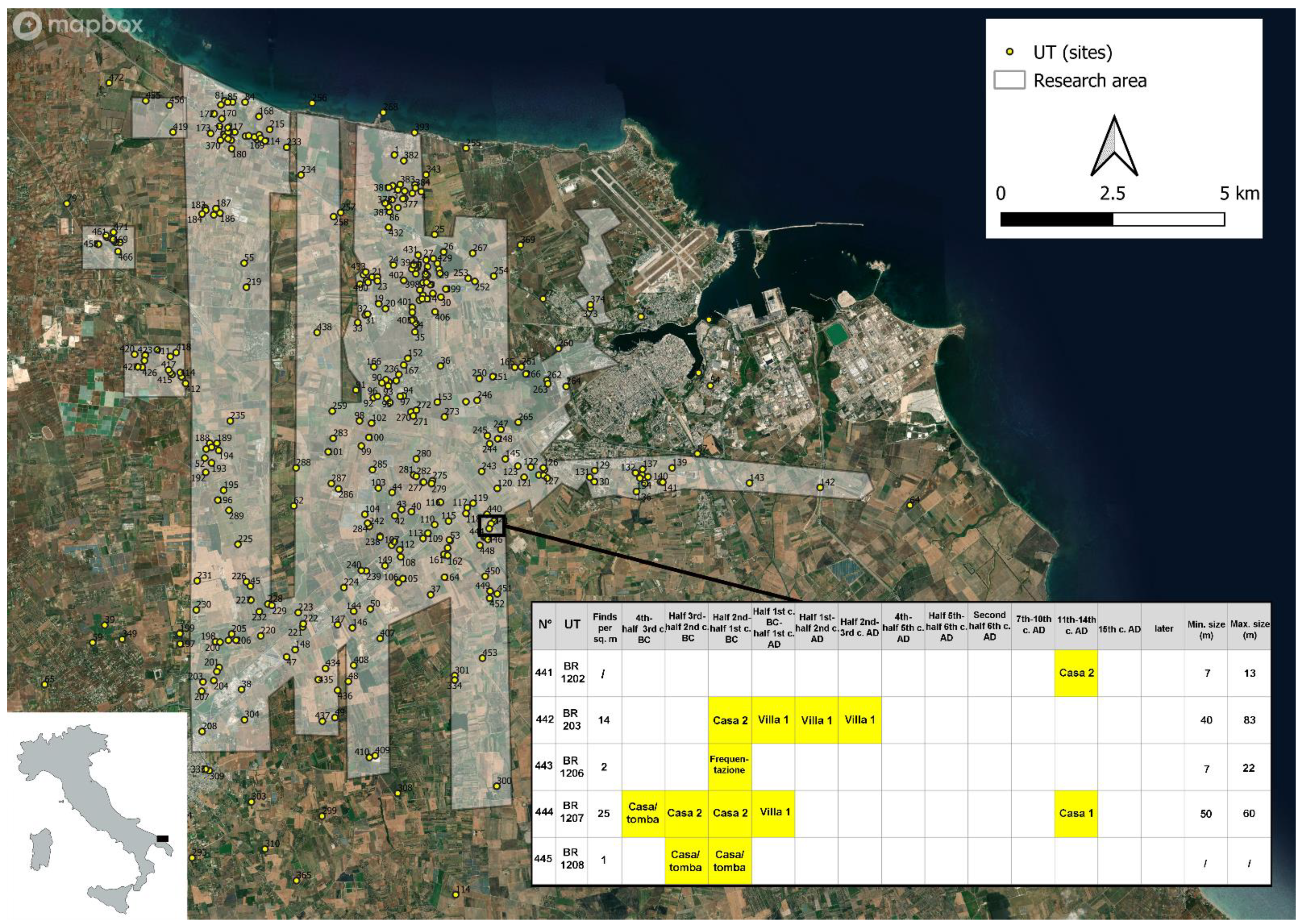
For these 73 case studies, all metadata were systematized and the research areas digitised (displayed in Figure 2 and Figure 3). For several of the case studies (see below), students first imported spatial coordinates of the site locations from the source publications or georeferenced scanned maps to mark in QGIS the surveyed units (if represented in the source publications) and site distributions, thus producing shapefiles/GeoJSON files, and then created spreadsheets to be associated to the attribute tables of the respective vector files in Excel (for an example, see Figure 4). These datasets underwent the supervisor’s quality check: the quality measures for both individual results and overall student team production were evaluated for the seven internship phases (see Section 2) and focused on a high degree of clarity and completeness in describing the metadata and procedures, and that there was well-ordered systematisation of the data storage in our shared drive.
Out of 73 case studies, the students completed 36 data digitisations with variable quality (see below). Namely, the research areas, the surveyed units walked within the research areas (if represented in the original publications), and all the sites discovered/located by previous surveys were digitised, along with the attribute tables that reported the respective characteristics (e.g., for sites: coordinates, type, chronology, size, and observed material; for units: area, visibility, and land-use conditions). However, of these 73 case studies, only 60 student digitisations can be considered of high quality (and, of these, 24 are unfinished) and usable by the project for studying ancient settlement patterns in the Western Mediterranean. This results in 6884 archaeological sites (3698 for Italy and 3186 for Iberia) and 113,104 ha of walked survey units (47,271 ha for Italy and 65,833 for Iberia) properly digitised through the internships.
High-quality converted data can enter the web and be shared with others for reuse. Students have begun entering these converted legacy data into online digital platforms, giving proper citation to the source publications (i.e., surveys 3–11; 14–17; 19–30 in Figure 2, Table A1). Specifically, students used the Fasti Online Survey platform [74], which is an open source WebGIS application and online database of archaeological field surveys developed by the KNIR and AIAC (International Association for Classical Archaeology), with the MAGIS project (DePauw University) as a springboard [75,76,77,78]. Since 2016, the Fasti Online Survey platform permits researchers and students to publish open access data and metadata of survey projects with citable permalinks and a CC BY-SA 4.0 license [79]. The web data entry phase of the data digitised during the internships is not completed and will continue in the future. Future entry may potentially include other online portals and be carried out through new internship editions, our collaborators, or the researchers themselves.
Legacy survey data are intrinsically important considering their high value for heritage management in landscape planning, especially when data were collected in now disappeared landscapes as they constitute their only archaeological memory. This information is a major source of historical knowledge, and its digitisation is thus very necessary. Additionally, these data are extremely significant for landscape archaeology [29], but, to realise their full potential, it is necessary to first understand the dataset structure and the terminologies used. Previous surveys usually did not employ common standards in the description of their methodologies (when made explicit) and in the classification of sites and finds. This may lead to inconsistent categories between surveys, namely the same typology of a site being used in different ways by different surveys, or the same concept being used in different surveys to describe different types of archaeological sites (e.g., the terms ‘villa’, ‘farm’, or ‘site’).
This variability in semantic ontologies represents an obstacle to the integration, comparison, and analysis of legacy survey datasets. To deal with this issue, the student interns also engaged in critical analysis of field survey terminologies used in various case studies. Namely, through the deep study of the available documentation and group discussions based on source criticism, we tried to describe the divergent typological and methodological terms and concepts used by previous field surveys. Students also compared site definitions to the classification scheme that is being developed in the context of the Roman Hinterland Project—RHP [36,80,81] to find parallels and synchronize the legacy datasets according to the RHP standardized framework. The results of this semantic harmonisation of different terminologies are promising (and will be discussed in a forthcoming article), but only for certain legacy surveys, namely those that provided sufficient data documentation and methodological explanations of the survey design (i.e., metadata) in their final publications. Instead, for those field surveys that lack such information, the comparison and synchronization with existing vocabularies were impossible to carry out by our students, or, alternatively, were based on confidence levels using lists of descriptors.
2.2. Discussion of Methodological Challenges
The digitisation, integration, and comparison of legacy survey datasets through the GIS medium has its challenges [10], such as the variability of data formats, the differences in terminologies between surveys, and the lack of context on survey methodologies. Standardisation models (e.g., controlled vocabularies, fixed protocols, CIDOC-CRM ontology) currently being developed by scholars for the collection, synchronization, and reuse of survey data generally encounter problems when it comes to the integration of legacy datasets [81,82]. In the internships, we also experienced the same difficulties (see above). Namely, we realised first-hand that earlier surveys were methodologically and semantically very different, varying greatly from region to region, as well as regarding the data they produced. The lack of a shared pattern of argumentation and common reference and the often poor availability of documentation on survey designs and recording methods (i.e., metadata) implies that several legacy datasets cannot be aggregated with new survey datasets using the existing standardisation models.
Instead, reworking legacy datasets that provide enough metadata to comply with current standards may be possible. However, this operation entails a critical discussion and is time-consuming. This is precisely why student internships may be helpful. Testing and developing standardisation models for synchronising legacy survey datasets requires a great deal of experimentation on large heterogeneous data-samples. Therefore, a critical mass of diverse legacy data first needs to be collected, described in detail, and then digitised. These operations can be performed by student interns supervised by professionals. Only when these operations are fulfilled can scholars—or the students themselves—develop and test standardisation models on a large scale, choose suitable ones to combine multiple individual datasets, and eventually analyse them side-by-side.
Through student internships and online open access platforms, a large number of legacy datasets from different regions and periods can be made available (see Section 2.1). This is key because it would enable cross-comparisons of data trends on an interregional and/or regional level, which is necessary to identify patterns of complex social phenomena (e.g., past migrations, colonisation, economic exchange, land-use strategies) and analyse their evolution over time. The increased availability of digitised legacy survey datasets resulting from these and future internships may also trigger new data-mining to analyse these data and discover patterns, ultimately producing novel knowledge [83,84]. Additionally, researchers interested in standardisation models and semantic ontology for surveys will likewise benefit greatly from these student internships. The data samples from different regions that were collected, described, and digitised through these internships will allow scholars to experiment with classification schemes on a large scale, which is necessary to determine solutions to integrate and make legacy data comparable to new survey data.
3. Conclusions
An urgent issue in heritage management and landscape archaeology is how we can preserve legacy survey data, especially considering that archaeological sites are increasingly in danger of being lost forever due to urbanization, agriculture, and digital obsolescence, rendering new data impossible to collect. As a result, these data represent the only memory remaining of destroyed sites and landscapes for several regions of the world. Legacy survey data also constitute a major source of archaeological knowledge, providing crucial information, such as the location of sites, and aiding in the understanding of ancient settlement patterns. Therefore, if we are unable to secure and disseminate such data, this will disadvantage strategic foresight for heritage management or spatial rural planning and archaeological landscape analysis. The method presented in this paper offers a solution to counteract this situation: as demonstrated by the pilot study, not only is the method capable of bringing to light legacy survey data that are sometimes difficult to access and improving their preservation; it also assists their translation into FAIR data [85]. Indeed, by applying this method, legacy survey data may become more easily findable, accessible, interoperable, and reusable.
This can be achieved sustainably and resiliently by means of crowdsourcing (i.e., nichesourcing) based on student internship programs in data digitisation. Student internships, besides being a successful formula (also in times of crisis) for improving the accessibility and comparability of legacy survey datasets on a supranational scale, are also a way to train future generations of archaeologists in responsible digital data stewardship, open data, and comparative analysis of international survey traditions.
The use of WebGIS platforms powered by collaborative-mapping software for the digitisation, dissemination, and exchange of these data will play an increasingly vital role in the future (e.g., the Fasti Online Survey format, but also see other examples: Refs. [11,86,87,88,89,90,91]). Using these platforms, heritage professionals and scholars or students from various universities and institutes will be able to compare survey datasets across landscapes, thus gaining insight into past cultural processes (e.g., migration, colonisation, and land-use), opening a number of new research lines and directions that were hidden before. At a social level, these portals can facilitate heritage management in landscape planning. By having access through online platforms to survey data, stakeholders (e.g., local planners and engineers) and policymakers (e.g., UNESCO, cultural and environmental ministries, ICCROM, FAO) will be able to anticipate the impact of future developments on rural heritage, thus minimizing risks of heritage destruction in rural landscapes or, alternatively, developing plans for construction/agricultural works that take into account the archaeological record as sustainably as possible.
Funding
This project has benefitted from the generous support of the Prins Bernhard Cultuurfonds (Regato Fund). The sponsored study trips in Rome of the student interns were also supported by the Royal Netherlands Institute in Rome (KNIR).
Institutional Review Board Statement
Not applicable.
Informed Consent Statement
Not applicable.
Data Availability Statement
A portion of the survey projects and data presented in this article is openly available from Fasti Online Survey (https://www.fastionline.org/survey/ accessed on 21 September 2022).
Acknowledgments
This project has received funding from the Prins Bernhard Cultuurfonds (Regato Fund) in the context of the research program “The impact of Roman imperialism in the West” (PI Tesse D. Stek) based at Leiden University until 2021 and then at the University of Groningen. The internships have been sponsored by the aforementioned research program and the Royal Netherlands Institute in Rome (KNIR), which I thank for the warm hospitality. I would like to thank the enthusiastic students and early-career researchers who took part in our internships for their valuable help and efforts in collecting and digitising legacy survey data: Flavia Palazzini (Sapienza University of Rome), participant in the 2020 and 2022 internship editions; Claudio Sossio De Simone (University of Naples Federico II), participant in the 2020 internship edition; Dario D’Orlando (University of Cagliari), participant in the 2022 internship edition; Paolo Cremisini (Sapienza University of Rome), participant in the 2022 internship edition; António Diniz (University of Évora), participant in the 2021 internship edition; Gil Vilarinho (University of Évora), participant in the 2021 internship edition; Kiyoka Koizumi (Leiden University), participant in the 2021 internship edition; Martim Lopes (NOVA University Lisbon), participant in the 2021 internship edition; Newton Ribeiro Machado Neto (University of Coimbra), participant in the 2021 and 2022 internship editions; Sílvia Maciel (University of Minho), participant in the 2021 and 2022 internship editions; Bruno Gambinhas Leal (University of Évora), participant in the 2022 internship edition. Several colleagues helped me to organise the internships or provided advice, feedback, and fruitful discussions during them: Tesse D. Stek (KNIR, University of Groningen), André Carneiro (University of Évora), Jeremia Pelgrom (University of Groningen), Elizabeth Fentress (AIAC), Rogier Kalkers (Sapienza University of Rome), Martijn van Leusen (University of Groningen), and Martina Parini (University of Groningen). I am grateful to Tesse D. Stek and the four anonymous peer reviewers for their useful comments on this paper. In this work, there may be errors or omissions of bibliographic references due to the abundance, complexity, variability in structure, and dispersion of the legacy survey datasets that we attempted to collect and digitise during the internships. We hope that scholars will help us to improve our knowledge by sharing information about their survey projects through online portals, such as Fasti Online Survey.
Conflicts of Interest
The author declares no conflict of interest.
Appendix A
This Appendix reports the list of survey projects identified and digitally converted during the internships (both completed and partially digitised) for Central–Southern Italy (Table A1) and the Iberian Peninsula (Table A2). The list comprises topographic, extensive, and intensive field-surveys, and surveys where hybrid methods were employed (cf., the bibliographic references in the fourth column of Table A1 and Table A2 for information on the survey designs, survey project years, and field directors; for an overview of the different survey traditions, see Ref. [11]). The term ‘sites’ is used loosely and generally in the tables below; it includes all possible categories, of all prehistoric and/or historical periods and functions that were considered by the original survey projects, displayed as points, polygons, or lines in the source publications. ‘Sites’ may indicate site categories, such as huts, farms, villas, tombs, necropolis, villages, towns, etc.; ancient (infra)structures (e.g., remains of walls, floors, roads, aqueducts, etc.); or concentrations of archaeological materials (e.g., flint and other lithic tools, pottery sherds, fragments of bricks and tiles) belonging to archaeological sites discovered at the surface level by previous surveys. These previous surveys used different terms for site discoveries in the field (e.g., site, unità topografica, scatter, area di frammenti fittili, yacimientos, jaciments, dispersión de restos constructivos, mancha de ocupação, vestígios de superfície, etc.) and/or during interpretation of these remains in the laboratory (e.g., settlement, house, farm, villa, hut, habitat, tomb, necropolis, village, town, uncertain, etc.).

Table A1.
Survey projects digitised during the student internships for Central–Southern Italy (Figure 2).
Table A1.
Survey projects digitised during the student internships for Central–Southern Italy (Figure 2).
| Number in Figure 2 | Region | Survey Project | Source Publication(s) Used by Students for Data Digitisation | Research Area (ha) | Surveyed Units (ha) | Number of Sites | Digitisation Completed by Student Interns |
|---|---|---|---|---|---|---|---|
| 1 | Valle dell’Albegna, Grosseto, Tuscany, Italy | Paesaggi d’Etruria | [92] | 33,217 | n/a | 1621 | yes |
| 2 | Magliano Sabina—Collevecchio—Stimigliano, Lazio, Italy | Ager Foronovanus I | [93] | 4674 | n/a | 103 | yes |
| 3 | Termoli (CB)—Lesina (FG), Italy | R.F.I Termoli-Lesina survey | [94] | 909 | 909 | 61 | no |
| 4 | Biferno valley, Molise, Italy | Biferno Valley Archaeological Survey | [95,96] | 41,869 | 41,869 | 1164 | no |
| 5 | Campobasso, Molise, Italy | Larinum—Forma Italiae | [97] | 9616 | n/a | 305 | no |
| 6 | Campobasso, Molise, Italy | Carta archeologica della media Valle del Trigno | [98] | 22,898 | n/a | 63 | no |
| 7 | Campobasso, Molise, Italy | Carta del Rischio Archeologico nell’area del Cratere | [99] | 56,985 | n/a | 380 | no |
| 8 | Castropignano, Campobasso, Molise, Italy | Esperienze di survey a Castropignano | [100] | 9502 | n/a | 101 | no |
| 9 | Oratino, Campobasso, Molise, Italy | Esperienze di survey a Oratino | [101] | 1842 | n/a | 30 | no |
| 10 | Riccia, Campobasso, Molise, Italy | Esperienze di survey a Riccia | [102] | 6968 | n/a | 16 | no |
| 11 | Isernia, Molise, Italy | San Vincenzo al Volturno survey | [103] | 16,220 | yes | 195 | no |
| 12 | Caserta, Campania, Italy | Ager Calenus | [104] | 1301 | n/a | 29 | yes |
| 13 | Santa Maria Capua Vetere, Caserta, Campania, Italy | Ricognizioni archeologiche nel territorio ad Ovest di Capua | [105,106] | 5179 | n/a | 63 | yes |
| 14 | Apulia, Italy | Survey nella fascia pedemontana del Promontorio del Gargano | [107] | 8000 | yes | 258 | no |
| 15 | Foggia, Apulia, Italy | Progetto Ager Lucerinus | [108,109] | 10,430 | n/a | 1122 | no |
| 16 | Foggia, Apulia, Italy | Progetto Valle del Celone | [110,111] | 3500 | n/a | 264 | no |
| 17 | Faragola—Ascoli Satriano (FG), Apulia, Italy | Ricerche sistematiche nella valle del Carapelle | [112,113] | 4040 | yes | 117 | no |
| 18 | Valle dell’Ofanto, Foggia and Barletta-Andria-Trani, Apulia, Italy | Progetto Valle dell’Ofanto | [114,115,116] | 1892 | n/a | 113 | yes |
| 19 | Bari, Apulia, Italy | Ricognizioni sistematiche nel territorio di Terlizzi | [117,118,119] | 1350 | n/a | 41 | no |
| 20 | Genzano di Lucania—Banzi—Irsina, Basilicata, Italy | Basentello Valley Archaeological Research Project | [120,121,122,123,124,125,126] | 21,606 | 4015 | 216 | yes |
| 21 | Bari—Taranto, Italy | Ricognizioni della Via Appia tra Gravina in Puglia e Taranto | [127] | 1516 | n/a | 33 | no |
| 22 | Valle del Sinni, Basilicata, Italy | Carta archeologica della Valle del Sinni | [128] | 107,800 | n/a | 1078 | yes |
| 23 | Taranto, Apulia, Italy | L’Amastuola field surveys | [129,130] | 2937 | yes | 52 | no |
| 24 | Brindisi, Apulia, Italy | Murge Tableland project (MUR) e redazione Carta Archeologica di Cisternino | [131] | 10,129 | yes | 78 | no |
| 25 | Brindisi, Apulia, Italy | Ostuni field survey | [132] | 243 | 243 | 36 | no |
| 26 | Brindisi, Apulia | Oria field survey | [133] | 6240 | yes | 96 | no |
| 27 | Brindisi, Apulia, Italy | Archeologia dei paesaggi a Brindisi dalla romanizzazione al Medioevo | [72,73] | 10,129 | n/a | 475 | yes |
| 28 | Brindisi, Apulia, Italy | Valesio Field Survey | [134,135,136,137] | 1777 | yes | 79 | no |
| 29 | Lecce, Apulia, Italy | Portus Lupiae survey project | [138,139] | 10,019 | n/a | 150 | no |
| 30 | Lecce, Apulia, Italy | Field survey at Alezio | [140,141] | 235 | 235 | 3 | no |
Table A2.
Survey projects digitised during the student internships for the Iberian Peninsula (Figure 3).
Table A2.
Survey projects digitised during the student internships for the Iberian Peninsula (Figure 3).
| Number in Figure 3 | Region | Survey Project | Source Publication(s) Used by Students for Data Digitisation | Research Area (ha) | Surveyed Units (ha) | Number of Sites | Digitisation Completed by Student Interns |
|---|---|---|---|---|---|---|---|
| 1 | Vila Nova de Foz Côa, Guarda, Portugal | Carta Arqueológica do Concelho de Vila Nova de Foz Côa | [142] | 39,809 | n/a | 195 | no |
| 2 | Concelho de Lamego e Tarouca, Viseu, Portugal | Povoamento Romano dos Vales do Varosa e Balsemão | [143] | 15,451 | n/a | 29 | yes |
| 3 | Figueira de Castelo Rodrigo, Portugal | Torre de Almofala (civitas Cobelcorum) | [144] | 3850 | 3850 | 62 | no |
| 4 | Celorico da Beira, Portugal | Bacia de Celorico | [145] | 39,323 | 115 | 74 | yes |
| 5 | Middle Coa River region, Portugal | Bacia média do rio Côa | [146,147] | 89,370 | n/a | 44 | no |
| 6 | Santa Comba Dão, Viseu district, Portugal | Dinâmicas de Povoamento no Concelho de Santa Comba Dão | [148] | 8304 | n/a | 34 | yes |
| 7 | Oliveira do Hospital, Portugal | O Povoamento Rural Romano Entre o Mondego e o Cobral | [149] | 25,649 | n/a | 50 | yes |
| 8 | Sabugal, Portugal | Alto Côa | [150] | 109,723 | n/a | 60 | yes |
| 9 | Cova da Beira, Portugal | Cova da Beira survey | [151] | 103,915 | n/a | 320 | yes |
| 10 | Fundão, Castelo Branco, Portugal | Povoamento rural romano ao longo da Ribeira da Meimoa | [152] | 4345 | n/a | 77 | yes |
| 11 | Quintas da Torre, Vale Prazeres, Fundão, Portugal | Torre dos Namorados survey | [153] | 2381 | n/a | 37 | yes |
| 12 | Monfortinho, Castelo Branco, Portugal | Entre Monfortinho e Castelo Branco | [154] | 17,550 | n/a | 28 | yes |
| 13 | Idanha-a-Velha, Portugal | Civitas Igaeditorum | [155,156] | 4443 | n/a | 99 | yes |
| 14 | Aljazede, Ansião, Leiria district, Portugal | Aljazede survey | [157] | 53 | yes | 72 | no |
| 15 | Óbidos, Portugal | Carta Arqueológica do Concelho de Óbidos | [158] | 13,921 | 1787 | 411 | no |
| 16 | Santarém, district of Santarém, Portugal | Carta Arqueológica do Concelho de Santarém | [159] | 56,020 | 655 | 37 | no |
| 17 | Fronteira, Portugal | Carta arqueológica do concelho de Fronteira | [160] | 24,861 | 6186 | 222 | yes |
| 18 | Arronches, Portalegre, Portugal | Contributo para a Carta Arqueológica do Concelho de Arronches | [161] | 31,460 | n/a | 177 | no |
| 19 | Elvas, Portalegre, Portugal | Ocupação rural romana no actual concelho de Elvas | [162] | 63,110 | n/a | 75 | yes |
| 20 | Estremoz, Évora, Portugal | Carta Arqueológica do Concelho de Estremoz | [163] | 51,377 | n/a | 218 | no |
| 21 | Arraiolos, Évora, Alentejo, Portugal | LAPA: Levantamento Arqueológico e Patrimonial de Arraiolos | [164,165] | 68,408 | 1336 | 199 | no |
| 22 | Palmela, Portugal | Carta Arqueológica do Concelho de Palmela | [166] | 46,087 | n/a | 102 | yes |
| 23 | Redondo, Évora, Portugal | Carta Arqueológica do Concelho de Redondo | [167] | 36,942 | n/a | 505 | no |
| 24 | Reguengos de Monsaraz, Évora, Portugal | EIA Reguengos | [168] | 15,871 | 3391 | 45 | yes |
| 25 | Cuba, Beja, Portugal | EIA Cuba Odivelas | [169] | 5655 | 1612 | 4 | yes |
| 26 | Vidigueira, Beja, Portugal | Carta Arqueológica do Concelho de Vidigueira | [170] | 31,594 | n/a | 185 | yes |
| 27 | Amareleja, Beja, Portugal | EIA Amareleja | [171] | 244 | 244 | 26 | yes |
| 28 | Pias, Beja, Portugal | EIA Pias | [172] | 4805 | 2909 | 78 | yes |
| 29 | Moura, Beja, Portugal | EIA Moura 1 | [173] | 6456 | 2081 | 39 | yes |
| 30 | Moura, Beja, Portugal | EIA Moura 2 | [174] | 2626 | n/a | 15 | yes |
| 31 | Ferreira do Alentejo, Beja, Portugal | EIA Penedrão | [175] | 326 | 298 | 8 | yes |
| 32 | Mértola, Beja, Alentejo, Portugal | Carta Arqueológica do Concelho de Mértola | [176,177,178] | 127,940 | n/a | 415 | no |
| 33 | São Miguel do Pinheiro, Mértola, Beja, Portugal | EIA São Miguel do Pinheiro | [179] | 2280 | n/a | 21 | yes |
| 34 | Lagoa, Algarve, Portugal | Carta Arqueológica do Concelho de Lagoa | [180] | 8825 | n/a | 184 | no |
| 35 | Tarragona, Catalonia, Spain | The survey of the territory of Tarragona | [181] | 5370 | 1131 | 49 | yes |
| 36 | Tarragona, Catalonia, Spain | Project Ager Tarraconensis (PAT) | [182] | 1543 | 414 | 9 | no |
| 37 | Valverde valley, Sierra de Gata, Cáceres, Spain | Sierra de Gata | [183] | 28,008 | n/a | 57 | yes |
| 38 | Alcántara, Extremadura, Spain | Alcántara survey | [184] | 70,907 | 47,211 | 46 | yes |
| 39 | Córdoba, Spain | Ager Cordubensis survey | [185] | 168,986 | n/a | 112 | yes |
| 40 | Bujalance, Montoro, Andújar, Spain | Bas-Guadalquivir—volume III | [186] | 165,920 | n/a | 407 | yes |
| 41 | Campiña de Córdoba, Spain | Prospecciones Arqueológicas en la Campiña de Córdoba | [187] | 148,062 | n/a | 316 | no |
| 42 | Ejica, Dos Hermanas, Los Palacios, Villafranca, Lebrija, Sanlúcar de Barrameda, Spain | Bas-Guadalquivir—volume IV | [188] | 285,034 | n/a | 607 | yes |
| 43 | Bolonia, Tarifa, Cadiz, Spain | Territorium de Baelo Claudia | [189] | 529 | n/a | 37 | no |
References
- Sánchez, M.L.; Cabrera, A.T.; Del Pulgar, M.L.G. Guidelines from the heritage field for the integration of landscape and heritage planning: A systematic literature review. Landsc. Urban Plan. 2020, 204, 103931. [Google Scholar] [CrossRef]
- Lane, P.J. Archaeology in the age of the Anthropocene: A critical assessment of its scope and societal contributions. J. Field Archaeol. 2015, 40, 485–498. [Google Scholar] [CrossRef]
- Renes, H. Historic Landscapes Without History? A Reconsideration of the Concept of Traditional Landscapes. Rural Landsc. Soc. Environ. Hist. 2015, 2, 1–11. [Google Scholar] [CrossRef]
- Smith, C. Stronger together: International collaboration in heritage management. Archeol. Calc. 2020, 31, 15–20. [Google Scholar]
- Agnoletti, M.; Santoro, A. The Italian national register of historical rural landscapes. In Cultural Heritage—Possibilities for Land-Centered Societal Development; Hernik, J., Walczycka, M., Sankowski, E., Harris, B.J., Eds.; Springer: Cham, Switzerland, 2022. [Google Scholar] [CrossRef]
- Ammerman, A.J. Surveys and archaeological research. Annu. Rev. Anthropol. 1981, 10, 63–88. [Google Scholar] [CrossRef]
- Barker, G.; Lloyd, J. (Eds.) Roman Landscapes: Archaeological Survey in the Mediterranean Region; British School at Rome: London, UK, 1991. [Google Scholar]
- Alcock, S.E.; Cherry, J.F. (Eds.) Side-by-Side Survey: Comparative Regional Studies in the Mediterranean World; Oxbow Books: Oxford, UK, 2004. [Google Scholar]
- Attema, P.; Bintliff, J.; van Leusen, M.; Bes, P.; de Haas, T.; Donev, D.; Jongman, W.; Kaptijn, E.; Mayoral, V.; Menchelli, S.; et al. A guide to good practice in Mediterranean surface survey projects. J. Greek Archaeol. 2020, 5, 1–62. [Google Scholar] [CrossRef]
- Witcher, R.E. (Re)surveying Mediterranean rural landscapes: GIS and legacy survey data. Internet Archaeol. 2008, 24. [Google Scholar] [CrossRef]
- Knodell, A.R.; Wilkinson, T.C.; Leppard, T.P.; Orengo, H.A. Survey Archaeology in the Mediterranean World: Regional Traditions and Contributions to Long-Term History. J. Archaeol. Res. 2022, 116, 1–67. [Google Scholar] [CrossRef]
- Kamermans, H.; van Leusen, M.; Verhagen, P. Archaeological Prediction and Risk Management. Alternatives to Current Practice; Leiden University Press: Leiden, The Netherlands, 2009. [Google Scholar]
- Trow, S. Farming, forestry, rural land management and archaeological historical landscapes in Europe. In Heritage Management of Farmed and Forested Landscapes in Europe; Trow, S., Byrnes, E., Holyoak, V., Eds.; Europae Archaeologiae Consilium: Budapest, Hungary, 2010; pp. 19–25. [Google Scholar]
- Casarotto, A. Location preference modeling alias predictive modeling for the study of archaeological contexts. In Predicting Prehistory. Predictive models and field research methods for detecting prehistoric contexts. In Proceedings of the International Workshop, Grosseto, Italy, 19–20 September 2013; Pizziolo, G., Sarti, L., Eds.; Museo e Istituto Fiorentino di Preistoria “Paolo Graziosi”: Florence, Italy, 2015. Millenni. Studi di Archeologia Preistorica 11. pp. 35–46. [Google Scholar]
- Holtorf, C. Embracing change: How cultural resilience is increased through cultural heritage. World Archaeol. 2018, 50, 639–650. [Google Scholar] [CrossRef]
- Egloff, B.J. Archaeological Heritage Conservation and Management; Archaeopress: Oxford, UK, 2019. [Google Scholar] [CrossRef]
- Barrientos, F.; Martin, J.; De Luca, C.; Tondelli, S.; Gómez-García-Bermejo, J.; Zalama Casanova, E. Computational methods and rural cultural & natural heritage: A review. J. Cult. Herit. 2021, 49, 250–259. [Google Scholar]
- Burgers, G.-J. Archaeology in the City: Themes and trends. In Archaeology in the City: Proceedings of the International Workshop, Amsterdam 16–17 October 2019; Burgers, G.-J., Cicala, L., Iliano, G., Quagliuolo, M., Eds.; Naus Editoria: Naples, Italy, 2021; pp. 11–22. [Google Scholar]
- Van den Dries, M.H. 2021 The Public Benefits of Archaeology According to the Public. Internet Archaeol. 2021, 57. [Google Scholar] [CrossRef]
- Bintliff, J.L.; Sbonias, K. (Eds.) Reconstructing Past Population Trends in Mediterranean Europe (3000 B.C.–A.D. 1800); Oxbow Books: Oxford, UK, 1999. [Google Scholar]
- Gil, E.A.; Gurt, J.M.; Palet, J.M. El Pasado Presente. Arqueologìa de los Paisajes en la Hispania Romana; Ediciones Universidad de Salamanca: Salamanca, Spain, 2004. [Google Scholar]
- Tartaron, T.F. Aegean prehistory as world archaeology: Recent trends in the archaeology of Bronze Age Greece. J. Archaeol. Res. 2008, 16, 83–161. [Google Scholar] [CrossRef]
- Attema, P.A.J.; Burgers, G.-J.; van Leusen, P.M. Regional Pathways to Complexity: Settlement and Land-Use Dynamics in Early Italy from the Bronze Age to the Republican Period; Amsterdam University Press: Amsterdam, The Netherlands, 2010. [Google Scholar]
- De Haas, T.C.A. Fields, Farms and Colonists: Intensive field Survey and Early Roman Colonization in the Pontine Region, Central Italy; Barkhuis & Groningen University Library: Groningen, The Netherlands, 2011. [Google Scholar]
- Pelgrom, J. Colonial Landscapes: Demography, Settlement Organization and Impact of Colonies Founded by Rome (4th–2nd Centuries B.C.). Ph.D. Thesis, Leiden University, Leiden, The Netherlands, 2012. [Google Scholar]
- Verhagen, P. 5.1. Biting off more than we can chew? The current and future role of digital techniques in landscape archaeology. In Landscape Archaeology between Art and Science: From a Multi- to an Interdisciplinary Approach; Kluiving, S., Guttmann-Bond, E., Eds.; Amsterdam University Press: Amsterdam, The Netherlands, 2012; pp. 309–320. [Google Scholar]
- Walsh, K. The Archaeology of Mediterranean Landscapes: Human-Environment Interaction from the Neolithic to the Roman Period; Cambridge University Press: Cambridge, UK, 2014. [Google Scholar]
- Casarotto, A.; Pelgrom, J.; Stek, T.D. Testing settlement models in the early Roman colonial landscapes of Venusia (291 B.C.), Cosa (273 B.C.) and Aesernia (263 B.C.). J. Field Archaeol. 2016, 41, 568–586. [Google Scholar] [CrossRef]
- Casarotto, A. Spatial Patterns in Landscape Archaeology. A GIS Procedure to Study Settlement Organization in Early Roman Colonial Territories; Leiden University Press: Leiden, The Netherlands, 2018. [Google Scholar]
- Pelgrom, J. The Roman rural exceptionality thesis revisited. MEFRA 2018, 130, 69–103. [Google Scholar] [CrossRef]
- Stek, T.D. Early Roman colonization beyond the Romanizing agro-town: Village patterns of settlement and highland exploitation in Central Italy. In The Archaeology of Imperial Landscapes; Düring, B.S., Stek, T.D., Eds.; Cambridge University Press: Cambridge, UK, 2018; pp. 145–172. [Google Scholar]
- Bevan, A.; Palmisano, A.; Woodbridge, J.; Fyfe, R.; Roberts, C.N.; Shennan, S. The changing face of the Mediterranean—Land cover, demography and environmental change: Introduction and overview. Holocene 2019, 29, 703–707. [Google Scholar] [CrossRef]
- Patterson, H.; Witcher, R.; di Giuseppe, H. The Changing Landscapes of Rome’s Northern Hinterland; The British School at Rome’s Tiber Valley Project; Archaeopress: Oxford, UK, 2020. [Google Scholar]
- Kluiving, S.; Lidén, K.; Fredengren, C. Environmental humanities: A rethinking of landscape archaeology? In Environmental Humanities a Rethinking of Landscape Archaeology? Interdisciplinary Academic Research Related to Different Perspectives of Landscapes; Kluiving, S., Lidén, K., Fredengren, C., Eds.; Sidestone Press: Leiden, The Netherlands, 2021; pp. 7–12. [Google Scholar]
- Verhagen, P.; de Kleijn, M.; Joyce, J. Different Models, Different Outcomes? A Comparison of Approaches to Land Use Modeling in the Dutch Limes. Heritage 2021, 4, 2081–2104. [Google Scholar] [CrossRef]
- Attema, P.A.J.; Carafa, P.; Jongman, W.M.; Smith, C.J.; Bronkhorst, A.J.; Capanna, M.C.; de Haas, T.C.A.; van Leusen, P.M.; Tol, G.W.; Witcher, R.E.; et al. The Roman Hinterland Project: Integrating Archaeological Field Surveys around Rome and Beyond. Eur. J. Archaeol. 2022, 25, 238–258. [Google Scholar] [CrossRef]
- Mayoral, V.; Perea, L.S.; García, C.M.; Parini, M.C. Exploring the complexity of Roman agrarian landscapes. State of the art and a study case from the Southwestern Iberian Peninsula. In The Archaeology of Peasantry in Roman Spain; Tirado, J.B., Grau Mira, I., Eds.; De Gruyter: Berlin, Germany, 2022; pp. 111–142. [Google Scholar] [CrossRef]
- Amato, F.; Martellozzo, F.; Nolè, G.; Murgante, B. Preserving cultural heritage by supporting landscape planning with quantitative predictions of soil consumption. J. Cult. Herit. 2017, 23, 44–54. [Google Scholar] [CrossRef]
- González-Ruibal, A. Beyond the Anthropocene: Defining the Age of Destruction. Nor. Archaeol. Rev. 2018, 51, 10–21. [Google Scholar] [CrossRef]
- Gibbard, P.; Walker, M.; Bauer, A.; Edgeworth, M.; Edwards, L.; Ellis, E.; Finney, S.; Gill, J.L.; Maslin, M.; Merritts, D.; et al. The Anthropocene as an Event, Not an Epoch. J. Quat. Sci. 2022, 37, 395–399. [Google Scholar] [CrossRef]
- Ruiz Zapatero, G. La prospeccion de superficie en la arqueologia espanola. Quad. Prehist. Arqueol. Castello 1996, 17, 7–20. [Google Scholar]
- Cherry, J.F. Archaeology beyond the site: Regional survey and its future. In Theory and Practice in Mediterranean Archaeology: Old World and New World Perspectives; Papadopoulos, J.K., Leventhal, R.M., Eds.; UCLA Cotsen Institute of Archaeology Monograph Series: Los Angeles, CA, USA, 2003; pp. 137–159. [Google Scholar]
- Corazza, V.; Di Renzoni, A.; Ferranti, F. Tutti a spasso: Dal Crati al Po passando per il Tevere, cinquant’anni di camminate per campi. In 150 di Preistoria e Protostoria in Italia; Guidi, A., Ed.; IIPP: Florence, Italy, 2014; pp. 543–549. [Google Scholar]
- Crumley, C.L.; Kolen, J.C.A.; de Kleijn, M.; van Manen, N. Studying long-term changes in cultural landscapes: Outlines of a research framework and protocol. Landsc. Res. 2017, 42, 880–890. [Google Scholar] [CrossRef]
- Turner, S.; Kinnaird, T.; Koparal, E.; Lekakis, S.; Sevara, C. Landscape archaeology, sustainability and the necessity of change. World Archaeol. 2020, 52, 589–606. [Google Scholar] [CrossRef]
- Erdoğan, N.; Carrer, F.; Tonyaloğlu, E.E.; Çavdar, B.; Varinlioğlu, G.; Şerifoğlu, T.E.; Jackson, M.; Kurtsan, K.; Nurlu, E.; Turner, S. Simulating change in cultural landscapes: The integration of historic landscape characterisation and computer modelling. Landscapes 2020, 21, 168–182. [Google Scholar] [CrossRef]
- Högberg, A.; Holtorf, C.; May, S.; Wollentz, G. No future in archaeological heritage management? World Archaeol. 2017, 49, 639–647. [Google Scholar] [CrossRef]
- Holtorf, C.; Högberg, A. Cultural Heritage and the Future, 1st ed.; Routledge: London, UK, 2020. [Google Scholar]
- Burgers, G.-J. Tourism, leisure and cultural heritage: The challenge of participatory planning and design. In Tourism and Regional Science. New Frontiers in Regional Science: Asian Perspectives; Suzuki, S., Kourtit, K., Nijkamp, P., Eds.; Springer: Singapore, 2021; pp. 71–85. [Google Scholar]
- Fentress, E. What are we counting for? In Extracting Meaning from Ploughsoil Assemblages; Francovich, R., Patterson, H., Barker, G., Eds.; Oxbow Books: Oxford, UK, 2000; pp. 44–52. [Google Scholar]
- Casarotto, A.; García Sánchez, J.; Stek, T.D.; Pelgrom, J. Surface visibility and the validity of settlement patterns in legacy survey datasets. FOLD&R Archaeol. Surv. Ser. 2021, 17, 1–12. [Google Scholar]
- Waagen, J.; de Reus, N.; Kalkers, R. OpenArchaeoSurvey, or ‘Being Educated by the Digital Fieldwork Assistant’. In Archaeology in the Digital Era, Volume II. Computer Applications and Quantitative Methods in Archaeology, 2012; Graeme, E., Sly, T., Chrysanthi, A., Murrieta-Flores, P., Papadopoulos, C., Romanowska, I., Wheatley, D., Eds.; Amsterdam University Press: Amsterdam, The Netherlands, 2013; pp. 37–47. [Google Scholar]
- Arizza, M.; Boi, V.; Caravale, A.; Palombini, A.; Piergrossi, A. (Eds.) I dati archeologici. Accessibilità, proprietà, disseminazione (Roma, CNR, 23 maggio 2017). Archaeol. E Calc. 2018, 29. [Google Scholar]
- Moore, R.; Richards, J.D. Here today, gone tomorrow: Open access, open data and digital preservation. In Open Source Archaeology: Ethics and Practice; Wilson, A.T., Edwards, B., Eds.; De Gruyter Open: Warsaw, Poland, 2015; pp. 30–43. [Google Scholar]
- De Boer, V.; Hildebrand, M.; Aroyo, L.; de Leenheer, P.; Dijkshoorn, C.; Tesfa, B.; Schreiber, G. Nichesourcing: Harnessing the power of crowds of experts. In International Conference on Knowledge Engineering and Knowledge Management; ten Teije, A., Ed.; Springer: Berlin/Heidelberg, Germany, 2012; pp. 16–20. [Google Scholar]
- Vincent, M.L. Crowdsourced data for cultural heritage. In Heritage and Archaeology in the Digital Age. Quantitative Methods in the Humanities and Social Sciences; Vincent, M.L., López-Menchero Bendicho, V., Ioannides, M., Levy, T.E., Eds.; Springer: Cham, Switzerland, 2017; pp. 79–91. [Google Scholar]
- Dijkshoorn, C.; de Boer, V.; Aroyo, L.; Schreiber, G. Accurator: Nichesourcing for cultural heritage. arXiv 2017, arXiv:1709.09249. [Google Scholar]
- Scerri, E.M.; Kühnert, D.; Blinkhorn, J.; Groucutt, H.S.; Roberts, P.; Nicoll, K.; Zerboni, A.; Orijemie, E.A.; Barton, H.; Candy, I.; et al. Field-based sciences must transform in response to COVID-19. Nat. Ecol. Evol. 2020, 4, 1571–1574. [Google Scholar] [CrossRef]
- UNESCO. Reimagining Our Futures Together: A New Social Contract for Education. United Nations Educational; Scientific and Cultural Organization: Paris, France, 2021; Available online: https://unesdoc.unesco.org/ark:/48223/pf0000379707.locale=en (accessed on 7 August 2022).
- Gilissen, V.; Hollander, H. Archiving the Past While Keeping up with the Times. Stud. Digit. Herit. 2017, 1, 194–205. [Google Scholar] [CrossRef]
- Marwick, B.; d’Alpoim Guedes, J.; Barton, C.M.; Bates, L.A.; Baxter, M.; Bevan, A.; Bollwerk, E.A.; Bocinsky, R.K.; Brughmans, T.; Carter, A.K.; et al. Open Science in Archaeology. SAA Archaeol. Rec. 2017, 17, 8–14. [Google Scholar]
- Huggett, J. Reuse Remix Recycle: Repurposing Archaeological Digital Data. Adv. Archaeol. Pract. 2018, 6, 93–104. [Google Scholar] [CrossRef]
- Richards, J.D.; Jakobsson, U.; Novák, D.; Štular, B.; Wright, H. Digital Archiving in Archaeology: The State of the Art. Introduction. Internet Archaeol. 2021, 58. [Google Scholar] [CrossRef]
- Stek, T.D.; Carneiro, A. Introduction. In The Archaeology of Roman Portugal in its Western Mediterranean Context; Stek, T.D., Carneiro, A., Eds.; Oxbow Books: Oxford, UK, 2022; pp. IX–XV. [Google Scholar]
- Van Leusen, M. Unbiasing the archaeological record. Archeol. E Calc. 1996, 7, 129–135. [Google Scholar]
- Terrenato, N. The visibility of sites and the interpretation of field survey results: Towards an analysis of incomplete distributions. In Extracting Meaning from Ploughsoil Assemblages; Francovich, R., Patterson, H., Barker, G., Eds.; Oxbow Books: Oxford, UK, 2000; pp. 60–71. [Google Scholar]
- Vermeulen, F.; de Dapper, M. (Eds.) Geoarchaeology of the Landscapes of Classical Antiquity; Peeters: Leuven, Belgium, 2000. [Google Scholar]
- Banning, E.B. Archaeological Survey; Plenum Publisher: New York, NY, USA, 2002; pp. 39–79. [Google Scholar]
- Van Leusen, P.M. Pattern to Process: Methodological Investigations into the Formation and Interpretation of Spatial Patterns in Archaeological Landscapes. Ph.D. Thesis, University of Groningen, Groningen, The Netherlands, 2002. [Google Scholar]
- Feiken, M. Dealing with Biases: Three Geo-Archaeological Approaches to the Hidden Landscapes of Italy; Barkhuis: Eelde, The Netherlands, 2014. [Google Scholar]
- Casarotto, A.; Stek, T.D.; Pelgrom, J.; van Otterloo, R.H.; Sevink, J. Assessing visibility and geomorphological biases in regional field surveys: The case of Roman Aesernia. Geoarchaeology Int. J. 2018, 33, 177–192. [Google Scholar] [CrossRef] [Green Version]
- Manacorda, D.; Cambi, F. Recherches sur l’ager Brundisinus à l’époque romaine. In Structures Rurales et Sociétés Antiques. Actes du Colloque de Corfou (14–16 Mai 1992); Doukellis, P.N., Mendoni, L.G., Eds.; Université de Franche-Comté: Besançon, France, 1994; pp. 283–292. [Google Scholar]
- Aprosio, M. Archeologia dei Paesaggi a Brindisi dalla Romanizzazione al Medioevo; Edipuglia: Bari, Italy, 2008. [Google Scholar]
- Fasti Online Survey. Available online: https://www.fastionline.org/survey/ (accessed on 11 August 2022).
- Di Giuseppe, H.; Fentress, E. Dai Fasti archaeologici ai Fastionline. Ostraka 2004, 1, 129–132. [Google Scholar]
- Di Giuseppe, H.; Fentress, E.; Hunt, G. FastiOnLine. La comunicazione archeologica via web. In Vesuviana. Archeologie a Confronto, Atti del Convegno Internazionale (Bologna, 14–16 Gennaio 2008); Coralini, A., Ed.; Ante Quem: Bologna, Italy, 2010; pp. 801–808. [Google Scholar]
- Di Giuseppe, H.; Fentress, E. Open archaeology: I Fasti e la pubblicazione online. In Open Source, Free Software e Open Format nei Processi di Ricerca Archeologica, Atti del III Workshop (Padova, 8–9 Maggio 2008); Bezzi, L., Francisci, D., Grossi, P., Lotto, D., Eds.; Edizioni Quasar: Roma, Italy, 2012; pp. 85–94. [Google Scholar]
- Johnson, M.; Laino, F.; Eve, S.; Fentress, E. Fasti online: Excavation, conservation and surveys. Twelve years of open access archaeological data online. In Oceans of Data, Proceedings of the 44th Conference Computer Applications and Quantitative Methods in Archaeology (Oslo, 30 March–3 April 2016); Matsumoto, M., Uleberg, E., Eds.; Archaeopress Publishing Ltd.: Oxford, UK, 2018; pp. 245–251. [Google Scholar]
- Casarotto, A.; Palazzini, F.; de Simone, C.S.; Stek, T.D. Digital Field Survey Archaeology: Recupero di legacy data di ricognizioni di superficie con lo stage del KNIR. In Atti IAS 2020/2021, II Vol. In Fieri; Edizioni Quasar: Roma, Italy, accepted.
- Attema, P.I. Data integration and comparison in landscape archaeology: Towards analysis beyond sites and valleys. In Picenum and the Ager Gallicus at the Dawn of the Roman Conquest. Landscape Archaeology and Material Culture; Boschi, F., Giorgi, E., Vermeulen, F., Eds.; Archaeopress: Oxford, UK, 2020; pp. 11–17. [Google Scholar]
- Attema, P.; de Haas, T.; Tol, G.; Seubers, J. Towards an integrated database for the study of long-term settlement dynamics, economic performance and demography in the Pontine region and the hinterland of Rome. In Archaeology and Economy in the Ancient World: The Rural Foundations of The Roman Economy. New Approaches to Rome’s Ancient Countryside from the Archaic to the Early Imperial Period; Attema, P., Schörner, G., Eds.; Propylaeum: Berlin/Heidelberg, Germany, 2022; pp. 35–53. [Google Scholar] [CrossRef]
- De Haas, T.; van Leusen, M. FAIR survey: Improving documentation and archiving practices in archaeological field survey through CIDOC CRM. FOLD Res. 2020, 12, 1–15. [Google Scholar]
- Gattiglia, G. Think big about data: Archaeology and the Big Data challenge. Archäolog. Inf. 2015, 38, 113–124. [Google Scholar]
- Wernke, S.; VanValkenburgh, P.; Saito, A. Interregional Archaeology in the Age of Big Data: Building Online Collaborative Platforms for Virtual Survey in the Andes. J. Field Archaeol. 2020, 45 (Suppl. 1), S61–S74. [Google Scholar] [CrossRef]
- Wilkinson, M.D.; Dumontier, M.; Aalbersberg, I.J.; Appleton, G.; Axton, M.; Baak, A.; Blomberg, N.; Boiten, J.-W.; da Silva Santos, L.B.; Bourne, P.E.; et al. The FAIR Guiding Principles for Scientific Data Management and Stewardship. Sci. Data 2016, 3, 160018. [Google Scholar] [CrossRef]
- Serlorenzi, M.; Leoni, G. Il SITAR nella Rete della Ricerca Italiana. Verso la conoscenza archeologica condivisa, Atti del III Convegno (Roma 2013). Archeol. E Calc. 2015, (Suppl. 7). [Google Scholar]
- Meghini, C.; Scopigno, R.; Richards, J.; Wright, H.; Geser, G.; Cuy, S.; Fihn, J.; Fanini, B.; Hollander, H.; Niccolucci, F. ARIADNE: A Research Infrastructure for Archaeology. ACM J. Comput. Cult. Herit. 2017, 10, 1–27. [Google Scholar] [CrossRef]
- Wright, H.; Richards, J.D. Reflections on Collaborative Archaeology and Large-Scale Online Research Infrastructures. J. Field Archaeol. 2018, 43, S60–S67. [Google Scholar] [CrossRef]
- Bogdani, J. Archeologia e tecnologie di rete: Metodi strumenti e risorse digitali. In I Cardini di Groma 4; Bradypus: Roma, Italy, 2019. [Google Scholar]
- Moscati, P. Informatica archeologica e archeologia digitale: Le risposte dalla rete. Archeol. E Calc. 2019, 30, 21–38. [Google Scholar]
- Jakobsson, U.; Novak, D.; Richards, J.D.; Stular, B.; Wright, H. (Eds.) Digital Archiving in Archaeology: The State of the Art. Internet Archaeol. 2021, 58. Available online: https://intarch.ac.uk/journal/issue58/ (accessed on 11 August 2022).
- Carandini, A.; Cambi, F.; Celuzza, M.G.; Fentress, E. Paesaggi d’Etruria. Valle dell’Albegna, Valle d’Oro, Valle del Chiarone, Valle del Tafone; Edizioni di Storia e Letteratura: Rome, Italy, 2002. [Google Scholar]
- Verga, F. Ager Foronovanus I: (IGM 138 III SO/144 IV NO); Forma Italiae 44; Leo S. Olschki: Florence, Italy, 2006. [Google Scholar]
- Fratianni, G.; Panzetti, F. Attività di survey lungo la tratta R.F.I. Termoli—Lesina: Metodologia di indagine e nuovi dati. In Realtà Medioadriatiche a Confronto. Contatti e Scambi Tra le Due Sponde, Atti del Convegno, Termoli 22–23 Luglio 2016; De Benedittis, G., Ed.; Lampo: Campobasso, Italy, 2018; pp. 155–174. [Google Scholar]
- Barker, G. A Mediterranean Valley: Landscape Archaeology and Annales History in the Biferno Valley; Leicester University Press: London, UK; New York, NY, USA, 1995. [Google Scholar]
- Barker, G. (Ed.) The Biferno Valley Survey: The Archaeological and Geomorphological Record; Leicester University Press: London, UK; New York, NY, USA,, 1995. [Google Scholar]
- De Felice, E. Larinum; Forma Italiae 36; Leo S. Olschki: Florence, Italy, 1994. [Google Scholar]
- Fratianni, G. Terventum: Carta Archeologica della Media Valle del Trigno; Mario Congedo Editore: Martina Franca, Italy, 2010. [Google Scholar]
- Di Niro, A.; Santone, M.; Santoro, W. (Eds.) Carta del Rischio Archeologico Nell’area del Cratere: Primi Dati di Survey Nei Comuni Colpiti dal Sisma del 2002; Soprintendenza per i Beni Archeologi del Molise: Campobasso, Italy, 2010. [Google Scholar]
- Sardella, B. Esperienze di survey a Castropignano. In Molise Esperienze di Survey. Riccia, Oratino, Castropignano; De Benedittis, G., Ed.; Iresmo: Isernia, Italy, 2008; pp. 123–211. [Google Scholar]
- Tarasco, G. Esperienze di survey a Oratino. In Molise Esperienze di Survey. Riccia, Oratino, Castropignano; De Benedittis, G., Ed.; Iresmo: Isernia, Italy, 2008; pp. 62–121. [Google Scholar]
- Capozzi, A. Esperienze di Survey: Riccia. In Molise Esperienze di Survey. Riccia, Oratino, Castropignano; De Benedittis, G., Ed.; Iresmo: Isernia, Italy, 2008; pp. 13–62. [Google Scholar]
- Bowes, K.; Francis, K.; Hodges, R. (Eds.) Between text and territory: Survey and Excavations in the Terra of San Vincenzo Al Volturno; British School at Rome: London, UK, 2006. [Google Scholar]
- Compatangelo, R. L’Ager Calenus: Saggio di ricognizione topografica. In Accademia di Archeologia Lettere e Belle Arti di Napoli; Monumenti, V., Ed.; Arte tipografica: Napoli, Italy, 1985. [Google Scholar]
- Guandalini, F. Il territorio ad Ovest di Capua. In Carta Archeologica e Ricerche in Campania. Fascicolo 2: Comuni di Brezza, Capua, San Prisco; Atlante Tematico di Topografia Antica; Quilici, L., Quilici Gigli, S., Eds.; L’Erma di Bretschneider: Rome, Italy, 2004; Volume 15/2, pp. 11–72. [Google Scholar]
- Quilici, L.; Quilici Gigli, S. (Eds.) Carta Archeologica e Ricerche in Campania. Fascicolo 2: Comuni di Brezza, Capua, San Prisco; Atlante Tematico di Topografia Antica; L’Erma di Bretschneider: Rome, Italy, 2004; Volume 15. [Google Scholar]
- Monaco, A. Survey nella fascia pedemontana del Promontorio del Gargano: Potenzialità, difficoltà e prospettive di ricerca per le fasi preistoriche. In Atti 36° Convegno Nazionale sulla Preistoria, Protostoria, Storia della Daunia—San Severo, 14–15 Novembre 2015; Gravina, A., Ed.; Archeoclub San Severo: San Severo, Italy, 2016; pp. 181–196. [Google Scholar]
- Marchi, M.L.; Forte, G.; Savino, G.; Piergentili Margani, A. Il survey nell’Ager Lucerinus: Nuovi dati dai Monti Dauni settentrionali. In Atti 36° Convegno Nazionale sulla Preistoria, Protostoria, Storia della Daunia—San Severo, 14–15 Novembre 2015; Gravina, A., Ed.; Archeoclub San Severo: San Severo, Italy, 2016; pp. 311–329. [Google Scholar]
- Marchi, M.L. Riscoprendo i paesaggi archeologici: Nuovi dati per il progetto Ager Lucerinus dai territori di Castelnuovo della Daunia e Pietramontecorvino. In Atti 39° Convegno Nazionale sulla Preistoria, Protostoria, Storia della Daunia—San Severo, 17–18 Novembre 2018; Gravina, A., Ed.; Archeoclub San Severo: San Severo, Italy, 2019; pp. 3–26. [Google Scholar]
- Volpe, G. Linee di storia del paesaggio dell’Apulia Romana: San Giusto e la valle del Celone. In Modalità Insediative e Strutture Agrarie Nell’Italia Meridionale in Età Romana, Atti del Convegno Internazionale (Napoli 11–13 Giugno 1998); Lo Cascio, E., Storchi Marino, D., Eds.; Edipuglia: Bari, Italy, 2001; pp. 315–361. [Google Scholar]
- Volpe, G.; Romano, A.V.; Goffredo, R. Il “Progetto Valle del Celone”: Ricognizione, aerofotografia, GIS. In Progetto Durrës, Atti del II e del III Incontro Scientifico, Antichità Altoadriatiche 58; Buora, M., Santoro, S., Eds.; Editreg: Trieste, Italy, 2004; pp. 198–220. [Google Scholar]
- Goffredo, R.; Ficco, V. Tra Herdonia e Ausculum: I paesaggi di età daunia e romana della valle del Carapelle. In Faragola 1. Un Insediamento Rurale Nella Valle del Carapelle, Ricerche e Studi; Volpe, G., Turchiano, M., Eds.; Edipuglia: Bari, Italy, 2009; pp. 25–56. [Google Scholar]
- Goffredo, R.; Ficco, V.; Costantino, C. Ville e vici della valle del Carapelle (Puglia settentrionale). Approcci integrati allo studio dei paesaggi di età romana. MEFRA 2013, 125, 139–173. Available online: http://mefra.revues.org/1310 (accessed on 11 August 2022).
- Goffredo, R.; Volpe, G. Il “Progetto Valle dell’Ofanto”: Primi dati sulla Tarda Antichità e sull’Altomedioevo. In Atti del I Seminario sul Tardoantico e l’Altomedioevo in Italia Meridionale; Edipuglia: Bari, Italy, 2005; Volume 4, pp. 223–240. [Google Scholar]
- Goffredo, R.; Volpe, G. Fotografia aerea, archeologia globale e paesaggi antichi della Daunia. Esempi dalle valli dell’Ofanto e del Carapelle. Archeol. Aerea 2006, 2, 219–246. [Google Scholar]
- Goffredo, R. Aufidus. Storia, Archeologia, Paesaggi Della Valle dell’Ofanto; Edipuglia: Bari, Italy, 2011. [Google Scholar]
- Campese, M. Insediamenti Urbani e Rurali della Puglia Centrale tra l’età Tardoantica e la Conquista Normanna. Ph.D. Thesis, University of Foggia, Foggia, Italy, 2014. [Google Scholar]
- Campese, M.; De Santis, P.; Depalo, M.R.; Foscolo, M. Insediamenti rurali nella Puglia centrale tra tarda antichità e medioevo (secc. IV–XI): Nuovi dati da ricerche sistematiche nel territorio di Terlizzi (BA). In Atti del VII Congresso Nazionale di Archeologia Medievale (Lecce, 9–12 Settembre 2015); Arthur, P., Imperiale, M., Eds.; All’Insegna del Giglio: Florence, Italy, 2015; pp. 330–336. [Google Scholar]
- Campese, M.; De Santis, P.; Foscolo, M. L’habitat rurale della Puglia centrale: Nuove acquisizioni dal territorio di Terlizzi. In Paesaggi Mediterranei di età Romana. Archeologia, Tutela, Comunicazione; Mastrocinque, G., Ed.; Edipuglia: Bari, Italy, 2017; pp. 169–182. [Google Scholar]
- Small, A.; Small, C.; Campbell, I.; MacKinnon, M.; Prowse, T.; Sipe, C. Field survey in the Basentello valley on the Basilicata-Puglia border. Echos Monde Class. Class. Views 1998, 42, 337–371. [Google Scholar]
- McCallum, M. Rapporto sulle Attività Archeologiche nei Territori di Banzi, Genzano di Lucania, ed Irsina, Estate 2012; BVARP Report. 2012. Available online: https://www.smu.ca/webfiles/Rapporto-2012.pdf (accessed on 5 August 2022).
- McCallum, M. San Felice and the Basentello Valley Archaeological Research Project, July–August 2012 (Comune di Gravina in Puglia, Provincia di Bari, Regione Puglia). Pap. Br. Sch. Rome 2013, 81, 371–374. [Google Scholar] [CrossRef]
- McCallum, M.; Hyatt, A.; Baker, G.; MacDougall, J. Rapporto sulle Attività Archeologiche nei Territori di Genzano di Lucania e Irsina, Estate 2013, BVARP Report. 2013. Available online: https://www.academia.edu/9528817/Ricognizioni_Archeologiche_Territori_di_Genzano_di_Lucania_Irsina_e_Banzi_BVARP_2013 (accessed on 5 August 2022).
- McCallum, M.; Baker, G.; Garofalo, G.; Zotta, L.; Parsons, N. Rapporto sulle attività archeologiche nei territori di Genzano di Lucania e Irsina, estate 2014. BVARP report, 2014. BVARP report. 2014. [Google Scholar]
- McCallum, M.; Hyatt, A. San Felice and the Basentello Valley Archaeological Research Project, July–August 2013 (comune di Gravina in Puglia, provincia di Bari, regione Puglia). Pap. Br. Sch. Rome 2014, 82, 338–343. [Google Scholar] [CrossRef]
- McCallum, M.; Parsons, N.; Garofalo, G.; Zotta, L. The Basentello valley archaeological research project, July-August 2014 (comuni di Genzano di Lucania e Irsina, provincia di Potenza e Matera, regione Basilicata). Pap. Br. Sch. Rome 2015, 83, 319–323. [Google Scholar] [CrossRef]
- Piepoli, L. Il percorso della via Appia antica nell’Apulia et Calabria: Stato dell’arte e nuove acquisizioni sul tratto Gravina-Taranto. Vetera Christ. 2014, 51, 239–261. [Google Scholar]
- Quilici, L.; Quilici Gigli, S.Q. (Eds.) Carta Archeologica della Valle del Sinni; Atlante Tematico di Topografia Antica; Volume 10/1–8; L’Erma di Bretschneider: Rome, Italy, 2001. [Google Scholar]
- Burgers, G.J.; Crielaard, J.P. Greek colonists and indigenous populations at L’Amastuola, southern Italy. BABESCH 2007, 82, 77–114. [Google Scholar] [CrossRef]
- Burgers, G.-J.; Crielaard, J.P. Greci e Indigeni a L’Amastuola; Stampasud: Mottola, Italy, 2011. [Google Scholar]
- Burgers, G.-J.; Recchia, G. Ricognizioni Archeologiche Sull’altopiano delle Murge. La Carta Archeologica del Territorio di Cisternino; Claudio Grenzi Editore: Foggia, Italy, 2009. [Google Scholar]
- Burgers, G.-J.; Attema, P.A.J.; van Leusen, M. Walking the Murge. Interim report of the Ostuni field survey (Apulia, southern Italy). Studi Di Antich. 1998, 11, 257–282. [Google Scholar]
- Yntema, D.G. In Search of an Ancient Countryside. The Free University Field Survey at Oria, Province of Brindisi, South Italy, 1981–1983; Thesis Publishers: Amsterdam, The Netherlands, 1993. [Google Scholar]
- Boersma, J.S.; Burgers, G.J.; Yntema, D.G. The Valesio Project: Final Interim Report. BABESCH 1991, 66, 115–131. [Google Scholar]
- Burgers, G.-J. The Valesio Field Survey. BABESCH 1991, 66, 124–131. [Google Scholar]
- Yntema, D.G. The Settlement of Valesio, Southern Italy; Final Report on the Field Survey. BABESCH 1993, 68, 49–70. [Google Scholar]
- Burgers, G.-J. The Brindisino project of the Free University of Amsterdam. In Constructing Messapian Landscapes: Settlement Dynamics, Social Organization and Culture Contact in the Margins of Graeco-Roman Italy; Burgers, G.-J., Ed.; J.C. Gieben: Amsterdam, The Netherlands, 1998; pp. 18–21. [Google Scholar]
- Sammarco, M.; Marchi, S. Tra terra e mare: Ricerche lungo la costa di San Cataldo (Lecce). J. Anc. Topogr. 2012, 22, 107–132. [Google Scholar]
- Merico, A.; Sammarco, M. Archaeological Landscapes of Southern Apulia: Integration and Interpretation of GIS-Based Data in a Multi-Methodological Research. LAC2014 Proc. 2016, 1–8. [Google Scholar] [CrossRef] [Green Version]
- Fletcher, R.; Robinson, E.G.D. A simple GIS method for archaeological survey. Mediterr. Archaeol. 2003, 16, 125–135. [Google Scholar]
- Robinson, E.G.D.; Clarke, G.; Jackson, H.; Fairbairn, A.; Mairs, L. Recent Australian and New Zealand fieldwork in the Mediterranean region: Field survey at Alezio, 2001. Mediterr. Archaeol. 2003, 16, 149–189. [Google Scholar]
- Coixão, A.N.S. Carta Arqueológica do Concelho de Vila Nova de Foz Côa, 2nd ed.; Câmara Municipal de Vila Nova de Foz Côa: Guarda, Portugal, 2000. [Google Scholar]
- Teixeira, R. Elementos para o estudo da ocupação romana no Alto Douro: Bacia hidrográfica dos rios Varosa e Balsemão. DOURO–Estud. Doc. 1998, 3, 11–28. [Google Scholar]
- Lobão, J.C.; Marques, A.C.; Neves, D. Povoamento romano na área da Torre de Almofala (civitas Cobelcorum). In Lusitanos e Romanos no Nordeste da Lusitânia: 2. Jornadas de Património da Beira Interior; Guarda, 21 e 22 de Outubro de 2004 (Sala da Assembleia Municipal); Centro de Estudos Ibéricos: Guarda, Portugal, 2005; pp. 171–187. [Google Scholar]
- Marques, A.C.N. A Ocupação Romana na Bacia de Celorico. Master’s Thesis, University of Coimbra, Coimbra, Portugal, 2011. [Google Scholar]
- Perestrelo, M.S.G. O Povoamento Romano na Bacia Média do rio Côa e na Bacia da Ribeira de Massueime. Master’s Thesis, University of Coimbra, Coimbra, Portugal, 2000. [Google Scholar]
- Perestrelo, M.S.G. A Romanização na Bacia do Rio Côa; Parque Arqueológico Vale do Côa: Vila Nova Foz Côa, Portugal, 2003. [Google Scholar]
- Matos, P. Dinâmicas de Povoamento no Concelho de Santa Comba Dão: Do Período Romano à Idade Média. Master’s Thesis, University of Coimbra, Coimbra, Portugal, 2018. [Google Scholar]
- Brito, J.M. O Povoamento Rural Romano entre o Mondego e o Cobral. Master’s Thesis, University of Coimbra, Coimbra, Portugal, 2021. [Google Scholar]
- Osório, M. O Povoamento Romano do Alto Côa. Master’s Thesis, University of Coimbra, Coimbra, Portugal, 2000. [Google Scholar]
- Carvalho, P.C. Cova da Beira Ocupação e Exploração do Território na Época Romana; Instituto de Arqueologia: Coimbra, Portugal, 2007. [Google Scholar]
- Carvalho, P.C.; Ribeiro, C.; Silva, R.; Almeida, S. Povoamento rural romano ao longo da Ribeira da Meimoa–Fundão: 1a campanha de prospecção intensiva. Conimbriga 2002, 41, 127–152. [Google Scholar] [CrossRef]
- Ângelo, M. Torre dos Namorados (Quintas da Torre, Fundão)—Do Aglomerado Urbano Secundário Romano (?) à Comenda Medieval. Master’s Thesis, University of Coimbra, Coimbra, Portugal, 2013. [Google Scholar]
- Reis, M.P. Entre Monfortinho e Castelo Branco: Sítios arqueológicos romanos ao longo de um projecto rodoviário (IC31). In VI Encuentro de Arqueología del Suroeste; Avila, J.J., Bustamante-Álvarez, M., García Cabezas, M., Eds.; Ayuntamiento de Villafranca de los Barros: Villafranca de los Barros, Spain, 2014; pp. 1803–1830. [Google Scholar]
- Lacerda, S. Povoamento Rural Romano e Usos Potenciais da Terra em Torno da Capital da Civitas Igaeditanorum (Idanha-a-Velha, Portugal). Master’s Thesis, University of Coimbra, Coimbra, Portugal, 2017. [Google Scholar]
- Lacerda, S.; Osório, M.; Carvalho, P.C. Contributo para o estudo do povoamento rural de Igaedis (Civitas Igaeditanorum) através de um mapa de usos potenciais da terra (MUPT). Arch. Español De Arqueol. 2019, 92, 213–228. [Google Scholar] [CrossRef]
- Cravo, M. Estudo Arqueológico do Território Compreendido entre Aljazede/Ateanha, Chão de Ourique/Póvoa e Vale do Rio Dueça—Evolução Entre a Época Romana e Altomedieval. Master’s Thesis, University of Coimbra, Coimbra, Portugal, 2010. [Google Scholar]
- Fernandes, I.; Moreira, J.; Raposo, L. Estudo de Âmbito Arqueológico do Concelho de Óbidos—Vol. 1: Contextualização, Interpretação e Fichas de Sítio; Rede de Investigação, Inovação e Conhecimento: Óbidos, Portugal, 2008. [Google Scholar]
- Almeida, M.J. Carta Arqueológica do Concelho de Santarém—Relatório de progresso Junho de 2002, Plano Nacional de Trabalhos Arqueológicos—Acções Plurianuais de Investigação Programada; Câmara Municipal de Santarém: Santarém, Portugal, 2002. [Google Scholar]
- Carneiro, A. Carta Arqueológica do Concelho de Fronteira; Câmara Municipal de Fronteira, Edições Colibri: Lisbon, Portugal, 2005. [Google Scholar]
- Lopes, A. Contributo para a Carta Arqueológica do concelho de Arronches. Master’s Thesis, University of Évora, Évora, Portugal, 2015. [Google Scholar]
- Almeida, M.J. Ocupação Rural Romana no Actual Concelho de Elvas. Master’s Thesis, University of Coimbra, Coimbra, Portugal, 2000. [Google Scholar]
- Laranjo, M. Carta Arqueológica do Concelho de Estremoz: Da Época Romana à Época Moderna. Master’s Thesis, Nova University of Lisbon, Lisbon, Portugal, 2014. [Google Scholar]
- Rocha, L.; Santos, I. Contributo para o conhecimento do concelho de Arraiolos: O projecto LAPA. In Arqueologia em Portugal—150 Anos, Associação dos Arqueólogos Portugueses; Associação dos Arqueólogos Portugueses: Lisbon, Portugal, 2013; pp. 141–150. [Google Scholar]
- Rocha, L.; Santos, I.; Branco, G. Património(s) de Arraiolos; Câmara Municipal de Arraiolos: Arraiolos, Portugal, 2013. [Google Scholar]
- Fernandes, I.; Santos, M. Carta arqueológica do concelho de Palmela. In Palmela Arqueológica no Contexto da Região Interestuarina Sado-Tejo; Fernandes, I., Santos, M., Eds.; Município de Palmela: Palmela, Portugal, 2012; pp. 11–24. [Google Scholar]
- Calado, M.; Mataloto, R. Carta Arqueológica do Concelho de Redondo; Câmara Municipal de Redondo: Redondo, Portugal, 2001. [Google Scholar]
- Estudo de Impacte Ambiental: Circuito Hidráulico de Reguengos e Respectivo Bloco de Rega. EDIA—Empresa de Desenvolvimento e Infraestruturas do Alqueva, SA. 2016. Available online: https://siaia.apambiente.pt/AIA_Todos.aspx (accessed on 5 August 2022).
- Estudo de Impacte Ambiental do Circuito Hidráulico de Cuba-Odivelas e Respectivo Bloco de Rega. EDIA—Empresa de Desenvolvimento e Infra-estruturas do Alqueva, SA. 2016. Available online: https://siaia.apambiente.pt/AIA_Todos.aspx (accessed on 5 August 2022).
- Costa, L. Carta Arqueológica do Concelho de Vidigueira; Câmara Municipal de Vidigueira: Vidigueira, Portugal, 2016. [Google Scholar]
- Estudo de Impacte Ambiental: Central Fotovoltaica da Tapada; EDF en Portugal. 2018. Available online: https://siaia.apambiente.pt/AIA_Todos.aspx (accessed on 5 August 2022).
- Estudos de Impacte Ambiental do Projecto de Execução dos Blocos de Rega de Pias; Estudo de Impacte Ambiental, EDIA—Empresa de Desenvolvimento e Infra-Estruturas do Alqueva, SA. 2009. Available online: https://siaia.apambiente.pt/AIA_Todos.aspx (accessed on 5 August 2022).
- Estudos de Impacte Ambiental do Circuito Hidráulico Caliços-Machados e Blocos de Rega; Estudo de Impacte Ambiental, 6 Vols, EDIA—Empresa de Desenvolvimento e Infra-Estruturas do Alqueva, SA. 2010. Available online: https://siaia.apambiente.pt/AIA_Todos.aspx (accessed on 5 August 2022).
- Estudos de Impacte Ambiental do Projecto de Execução do Bloco Moura Gravítico; Estudo de Impacte Ambiental, 3 Vols., EDIA—Empresa de Desenvolvimento e Infra-Estruturas do Alqueva, SA. 2010. Available online: https://siaia.apambiente.pt/AIA_Todos.aspx (accessed on 5 August 2022).
- Estudo de Impacte Ambiental da Barragem do Penedrão; EDIA—Empresa de Desenvolvimento e Infra-estruturas do Alqueva, SA. 2008. Available online: https://siaia.apambiente.pt/AIA_Todos.aspx (accessed on 5 August 2022).
- Santos, A.R.; Palma, M.; Gómez, S.; Lopes, V. Carta Arqueológica do Concelho de Mértola. Vipasca Arqueol. E História 2007, 2, 703–707. [Google Scholar]
- Torres, C.; Rego, M.; Reimão, M.; Palma, M.; Macias, S.; Lopes, V. Carta Arqueológica do Concelho de Mértola; Campo Arqueológico de Mértola: Mértola, Portugal, 2012. [Google Scholar]
- Lopes, V. Mértola e o Seu Território na Antiguidade Tardia (Séculos IV–VIII). Ph.D. Thesis, University of Huelva, Huelva, Spain, 2014. [Google Scholar]
- Estudo de Impacte Ambiental da Central Solar de São Miguel do Pinheiro. Relatório Técnico. Matos, Fonseca & Associados—Estudos e Projectos Lda. 2019. Available online: https://siaia.apambiente.pt/AIA_Todos.aspx (accessed on 5 August 2022).
- Gomes, M.; Cardoso, J.; Alves, F. Levantamento Arqueológico do Algarve. Concelho de Lagoa; Câmara Municipal de Lagoa: Lagoa, Portugal, 1995. [Google Scholar]
- Carreté, N.J.M.; Keay, S.J.; Millett, M. A Roman Provincial Capital and its Hinterland: The Survey of the Territory of Tarragona, Spain, 1985–1990; Journal of Roman Archaeology: Ann Arbor, MI, USA, 1995; Volume S15. [Google Scholar]
- Prevosti, M.; Guitart, J. Ager Tarraconensis 2. El Poblament; Institut Català D’Arqueologia Clàssica: Tarragona, Spain, 2011. [Google Scholar]
- De Figuerola Paniagua, M.G. Arqueología Romana y Altomedieval de la Sierra de Gata (El Valle de Valverde. Provinvcia de Cáceres); Arqueologia Extremeña 6; Universidad de Extremadura: Cáceres, Spain, 1999. [Google Scholar]
- Martín Bravo, A.M. Metodología de prospección para la Edad del Hierro en la zona de Alcántara (Cáceres). Zephyrus 1994, 46, 183–194. [Google Scholar]
- Sánchez, M.D.C.R. El poblamiento rural del “Ager Cordubensis”: Patrones de asentamiento y evolución diacrónica. Anejos An. Arqueol. Cordob. 2009, 2, 21–44. [Google Scholar]
- Ponsich, M. Implantation Rurale Antique sur le Bas-Guadalquivir. III: Bujalance, Montoro, Andujar; Casa de Velázquez: Madrid, Spain, 1987. [Google Scholar]
- Morena, J.A.; Sanchez, M.; García-Ferrer, A. Prospecciones Arqueológicas en la Campiña de Córdoba; ETSIA: Córdoba, Spain, 1990. [Google Scholar]
- Ponsich, M. Implantation Rurale Antique sur le Bas-Guadalquivir. IV: Écija, Dos Hermanas, Los Palacios y Villafranca, Lebrija, Sanlúcar de Barrameda; Casa de Velázquez: Madrid, Spain, 1991. [Google Scholar]
- González, A.A.; Martínez, L.L.; Casasola, D.B. Prospecciones arqueológicas en el ‘territorium’ de Baelo Claudia: Nuevos elementos interpretativos. Almoraima Rev. Estud. Campogibraltareños 2001, 25, 115–132. [Google Scholar]
Figure 1.
Archaeologists during a field walking survey in Molise (Central–Southern Italy). Picture by Rogier Kalkers.
Figure 1.
Archaeologists during a field walking survey in Molise (Central–Southern Italy). Picture by Rogier Kalkers.

Figure 2.
Research areas of the survey projects digitised during the internships for Central–Southern Italy (numbers 1–30 in Table A1). Basemap: ESRI World Hillshade, accessed on 8 August 2022. Figure by author.
Figure 2.
Research areas of the survey projects digitised during the internships for Central–Southern Italy (numbers 1–30 in Table A1). Basemap: ESRI World Hillshade, accessed on 8 August 2022. Figure by author.

Figure 3.
Research areas of the survey projects digitised during the internships for the Iberian Peninsula (numbers 1–43 in Table A2). Basemap: ESRI World Hillshade, accessed on 11 August 2022. Figure by author.
Figure 3.
Research areas of the survey projects digitised during the internships for the Iberian Peninsula (numbers 1–43 in Table A2). Basemap: ESRI World Hillshade, accessed on 11 August 2022. Figure by author.

Figure 4.
Survey project number 27 (Table A1) published in [72,73]: the field campaigns were conducted in the years 1990–1994 in the Brindisi region, Apulia, Italy (basemap: Mapbox Satellite, accessed on 9 August 2022). In this figure, the site locations and research area are displayed. The example of the attribute table represented in the figure reports the main characteristics of the sites enclosed by the black rectangle (i.e., find density, type, chronology, size). Data digitisation during the internships by Paolo Cremisini and Flavia Palazzini (from Ref. [73]). Figure by author.

Publisher’s Note: MDPI stays neutral with regard to jurisdictional claims in published maps and institutional affiliations. |
© 2022 by the author. Licensee MDPI, Basel, Switzerland. This article is an open access article distributed under the terms and conditions of the Creative Commons Attribution (CC BY) license (https://creativecommons.org/licenses/by/4.0/).
Share and Cite
MDPI and ACS Style
Casarotto, A. Digitising Legacy Field Survey Data: A Methodological Approach Based on Student Internships. Digital 2022, 2, 422-443. https://doi.org/10.3390/digital2040023
AMA Style
Casarotto A. Digitising Legacy Field Survey Data: A Methodological Approach Based on Student Internships. Digital. 2022; 2(4):422-443. https://doi.org/10.3390/digital2040023
Chicago/Turabian StyleCasarotto, Anita. 2022. "Digitising Legacy Field Survey Data: A Methodological Approach Based on Student Internships" Digital 2, no. 4: 422-443. https://doi.org/10.3390/digital2040023