Article

Mapping Is Caring: Fostering Forest Preservation through Young Orang Rimba Initiatives

1
Department of Geography Education, Faculty of Education, Universitas Muhammadiyah Purwokerto, Banyumas 53182, Indonesia
2
People’s Planet Project (PPP), Keizersgracht 391, Amsterdam Centrum, 1016 EJ Amsterdam, The Netherlands
3
Social Science Department, Graduates School of Universitas Muhammadiyah Purwokerto, Banyumas 53182, Indonesia
4
Department of Civic Education, Faculty of Education, Universitas Muhammadiyah Purwokerto, Banyumas 53182, Indonesia
*
Author to whom correspondence should be addressed.
Earth 2023, 4(3), 676-690; https://doi.org/10.3390/earth4030035
Submission received: 8 July 2023 / Revised: 13 August 2023 / Accepted: 22 August 2023 / Published: 7 September 2023

Abstract

:
The UN Convention on the Rights of the Child, Article 12, states that young people should be able to participate in issues that affect them. In this study, the indigenous Orang Rimba community examines the natural resources of their area through mapping so that the community can be more aware of environmental changes and at the same time their culture can be preserved. This research employs participatory resource mapping (PRM) to gather information about how young Orang Rimba view the forest in relation to customs. The study includes workshops on using GPS and GIS as well as resource mapping activities in the forest ecosystem. Through the participatory resource mapping, the study successfully maps 12 sacred places, 6 animal sites, and 14 medicinal plants in a short survey. The young Orang Rimba were also capable of addressing current environmental issues, including deforestation events, and simultaneously protecting the forest through local cultural practices. The study recommends involving indigenous communities in natural resource protection and awareness through mapping activities from a young age.

Graphical Abstract

1. Introduction

Indigenous communities and their partners have been working to promote their rights and their community of academics, government, and formal institutions to eradicate structural injustices, evaluate policies toward equality, and acquire social and environmental benefits and collaboration [1,2]. The collaborative project involving mapping activity here is essential, especially for indigenous communities [3]. The participatory mapping project is part of the general idea of empowering local communities in the identification, discussion, and preparation of solutions for specific problems. It includes environmental issues [4], hazard identification [5,6], and also natural resource conservation [7,8]. With current geospatial technology improvements, participatory mapping (p-mapping) is commonly implemented by using Geographic Information System (GIS) [9,10].
P-mapping studies natural resources that are unexplored, especially within indigenous communities [11]. However, few inquiries organized by scientists and non-governmental organizations (NGOs) have successfully combined fundamental mapping technique and local information, including in disaster mitigation [12,13,14]. In addition to that, this approach is applicable in the context of ecosystem service assessments [10,15] and indigenous forest management [8,16,17]. Currently, p-mapping is centered on this approach due to the spatial and context-based nature of vulnerability issues and respect for local knowledge [18].
In the beginning, p-mapping was practiced by most indigenous people to claim or reclaim their territorial land that was lost to other communities under colonial or after colonial administration [19]. P-mapping involves local people and can disclose the peculiar knowledge of indigenous people, enhance geographic understanding, and open discussions of the endeavors and expectations of indigenous people [20,21]. Along with that, Geographic Information System (GIS) has been used to tackle issues with reasonable costs [22,23] and at the same time exploit the local spatial knowledge [24]. Through that, participatory GIS (PGIS) was developed in the 1990s as a response to mapping needs and the function of GIS in social empowerment [25]. In addition, p-mapping extracts symbolize and validate spatial knowledge, which is hard to visualize in a conventional map, with additional specific data and elements of concern mapped by local people [16]. The PGIS approach also includes indigenous people or local participants in the collection of Global Positioning System (GPS) data points [26]. Thus, researchers can mark exciting locations in georeferenced data and store it using GIS software. However, it should be noticed that the essence of this activity is the GIS’s participatory process [22].
For several years, participatory mapping has also been combined with GIS and practiced in local communities in rural land-use planning [27], disaster mitigation [28], natural resource inventory [15,29,30], and ecosystem services [31]. In summary, the benefit of p-mapping or PGIS follows from its fundamental principles of (a) empowering through participation; (b) flexibility, adaptiveness, and continuity; (c) respect for indigenous knowledge; (d) awareness and deployment of local and locational specificity; and (e) being responsive to and understanding of the recognition of agency and control [19].
Participatory resource mapping (PRM) is a tool developed by researchers and practitioners of participatory methods to gather information systematically and graphically [8], obtain general overviews [32], and understand the resources available in communities and their association with social, economic, demographical, and geographical details of the living area [33]. Meanwhile, indigenous communities worldwide have been employing maps to secure their territories and administrate their natural land resources [34]. This method aims to develop a resource map in the present and the former situation at the landscape level [33]. PRM has been mentioned as an effective tool that enables communities to articulate their understanding of their physical environment [35]. Those previously mentioned studies also proposed the urgency of resource protection, especially for indigenous communities, as a significant part of forest sustainability [36].
Our study aimed to (a) assess the potential of a GPS survey to collect natural resource information and (b) (as previously presented by Paneque-Gálvez et al. [37]) evaluate to what extent the Global Positioning System tools and indigenous knowledge could be employed by the young indigenous community with different levels of understanding of GIS technology [38,39]. This article is organized into five sections in alignment with the previously outlined objectives. Section 2 provides an overview of the geographical context in which the study was conducted, focusing on the active involvement of the young indigenous community in the workshops and surveys. The methodological approach is elucidated in Section 3, encompassing the subject profiles, training, and workshops designed to enhance the capacity of participatory mapping. Section 4 comprehensively evaluates the outcomes of the participatory mapping endeavors and engages in a thorough discussion of the findings, including the results derived from the efforts of the young participants and the implications of technology transfer. Furthermore, this section critically analyzes the presented results. The final section, Section 5, encompasses concluding remarks, proposed recommendations, and suggestions for future research endeavors.

2. Geographical Settings

This study primarily focuses on the Jambi Province in Indonesia, encompassing workshop and mapping activities. The workshop events took place in Bangko, the administrative center of the Merangin regency, while the survey was conducted within a specific portion of the area of the Bukit Duabelas National Park (BDNP) in the Tebo regency as shown in Figure 1 (for further details, refer to Section 3.2 and Section 3.3). Bangko is an urbanized area situated approximately 150 km away from Jambi. The local population in this region exceeds 355,718 individuals, with the Malay ethnic group being the predominant demographic [40]. Furthermore, the majority of the inhabitants are actively engaged in agricultural pursuits. The geographical landscape of this area comprises hilly to mountainous terrain, ranging in elevation from 60 to 1035 m above sea level.
The BDNP is known as the tropical rainforest ecosystem in Jambi Province. The type of soil in this national park predominantly consists of podzol red-yellow and alluvial soil. This soil is responsive to erosion, especially during the rainy season. Recently, more than 200 species have been protected, including the Sumatran palm, pitcher plant, Agila wood, and Kulim tree [41]. In the early 2000s, regarding Ministry of Forestry Regulation 285/Kpts-II/2000, the area of the BDNP was designated to cover 60,500 hectares within three districts, including Sarolangun (6578 ha), Batanghari (41,259 ha), and Tebo (12,483 ha). During that period, there was a massive expansion of palm oil and rubber plantations that decreased the coverage of the national park [42]. A renewal regulation was made on 10 June 2014 to minimize the existing national park area. Based on Ministry of Forestry Decree SK.4196/Menhut-II/2014, the national park covers 54,780.51 hectares [43]. At present, the BDNP is structured to be part of the central government technical implementation unit (UPT) from the Ministry of Environment and Forestry (KLHK) with the main task of protecting, preserving, and utilizing [44].

3. Methods

The study on implementing participatory mapping with young people is still limited but increasing [45]. Recently, youth community mapping has been applied to different agendas, especially in urban settings [46,47]. Through legislation, international institutions have involved children and younger generations in participative planning activities. It should be noted that the UN Convention on the Rights of the Child, Article 12, states that children (or individuals less than 18 years old) should be allowed to influence issues that concern them, such as their environment [48]. In many cases, the entrance of participatory tools is via asking children about their experiences and observations [49]. Within the context of the current study, the p-mapping is focused on the context of natural resource preservation through participatory resource mapping (PRM). Here, a case study on the young Orang Rimba tribe has been chosen to examine the potential application of GIS by the indigenous community in mapping significant places.

3.1. Profile of Orang Rimba

Currently, Orang Rimba are considered one of the minority ethnic groups in Southeast Asia. They live in the lowland rainforest in Jambi, Indonesia [50]. Orang Rimba communities live between the Batanghari River and the lower part of Bukit Barisan [51,52]. According to a BDNP census in 2018, there were 718 families, or 2960 Orang Rimba, living in the national park [53]. Orang Rimba believe that the forest has been the primary source of their life for a long time, including food, housing, and traditional medicine [50,54,55]. Orang Rimba are recognized as a semi-nomadic community and live through gardening [52,54,56]. They live in simple huts in small groups composed of many families [57]. This community developed swidden gardening and digs wild yams and shift during a community member’s death [54]. The indigenous group occasionally collects honey as part of their cultural performance [58]. Furthermore, this community also practices hunting, trapping, fishing, and trading of forest products.
During the 1960s and 1970s, the national authority called Orang Rimba Suku Anak Dalam (SAD) [57]. They live in groups of 20 people and have one “Tengganai” in the top hierarchical fixture [53]. Currently, they are acknowledged to consist of numerous groups (locally called “rombongan”), including the Makekal, Air Hitam, and Terap groups that are named after rivers [59]. Each of them is led by a “Temenggung”, while each group consists of several families, “bubung” [60]. On a daily basis, Orang Rimba have to follow the traditional customs that are already constituted in the form of “seloko-seloko” (custom rule). Those rules guide all the community members, including the leader, “Temenggung”, to make a decisions for the people [58,61].
Currently, Jambi Province has 4 national parks, including Kerinci Seblat National Park (KSNP), Berbak National Park (BNP), Bukit Tigapuluh National Park (BTNP), and Bukit Duabelas National Park (BDNP). The BDNP contains a fraction of lowland rainforests [62]. Orang Rimba in Bukit Duabelas National Park (BDNP) also preserve the social and cultural system, which is expressed in their cosmology and supported by costumed legal and political structures [50]. Nevertheless, the communities have been facing considerable pressure on their livelihood due to plantation expansion, national park conservations, and transmigration openings [63,64]. As mentioned in a KKI WARSI report in 2012, there were 78 oil palm plantation companies in Jambi, overlapping with locations where Orang Rimba lived [64]. With massive deforestation, Orang Rimba have lost their places of living and dwelling [65]. Recently, almost 75% of the total 96 groups of Orang Rimba no longer live in the BDNP [64].

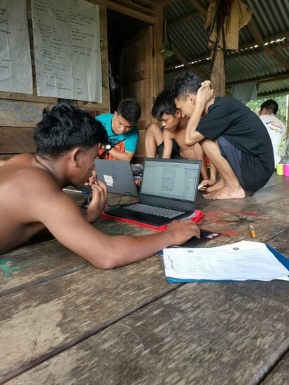
3.2. First Workshop: Basic Cartography and Utilization of GPS

This study was conducted in collaboration with universities and NGOs. This paper presents participatory workshops, field data collection, and GIS processing in a reliable platform as components of the participatory mapping initiation. Firstly, in May 2022, fieldwork was initiated with a preliminary online meeting to set up the plan and proposal. This p-mapping project collaborated with Kelompok Makekal Bersatu (KMB), one of the largest groups of Orang Rimba who live in the upper part of the Makekal River, Jambi Province. Currently, there are more than 500 people that belong in this group with a coverage area of 4162.13 hectares [66]. This study was mainly coordinated by the People’s Planet Project (PPP) under the umbrella of GeoStory Camps (information related to this program is accessible at https://www.peoplesplanetproject.org/, accessed on 30 October 2022). Before the current project, the PPP also performed GeoStory camps in the Xingu community in the Amazon in 2021 in cooperation with a local NGO. For the current project in Jambi, there were 6 young participants involved in two weeks of training. This project also involved 2 mentors from Sokola Rimba (or the Jungle School) established by Butet Manurung, concerned with indigenous children’s education as local partners [56,65].
The training had two options for skills: movie making and mapping. The training consisted of 3 blocks for mapping, including introduction, practical use of GPS, and GIS application. The sessions typically lasted for several days, and most activities took place in the morning [26]. As a form of reciprocity and compensation, we provided breakfast and lunch. All training was centered in the Jungle School class where young Orang Rimba learn basic literacy and numeracy with their guru or mentors who fluently speak in the local language called Kubu. All training was held in the Indonesian language (Bahasa), which all participants could understand. In the field, the activities were handled by a team of six people, including two geographers, two facilitators, one manager, and one director. The first two professionals had formal training in remote sensing and GIS (RS-GIS), GPS device operation, and cartography skills. At the same time, others had prior experience in community development and conducting interviews. Four team members were Indonesian, while the other two were from the Netherlands and Australia. All monitoring, coordination, and evaluation among trainers and organizers were conducted in Bahasa and English.
Before mapping, the overall technical approach was discussed with the participants during the workshop. As needed, minor adjustments to the process were made. Using a conventional map from the National Geospatial Agency of Indonesia or locally referred to as Badan Informasi Geospasial (BIG), several standardized maps were displayed in response to some open-ended questions regarding the primary function of the map. In addition, the spatial information could be read using a legend (Figure 2a). Further, cartography, map visualization, and adequate justifications on satellite imagery are essential. Here, we used the online version of high-resolution satellite imagery from Google Earth. Google Earth is a very intuitive platform that is easily mastered by the young generation [49]. The training was combined with an outdoor activity using GPS. The participants practiced creating points and routes and identifying objects using prepared maps in two small teams with one GPS device (Garmin 64s) for each group. This initial step was conducted in the surrounding area of the Jungle School in Bangko. This activity also involved tracking and pointing to important places, including schools, shops, traditional markets, and sport centers (see Figure 2b). The trainers also guided the participants by using the survey sheet containing coordinates and the names of the places. After the training that day, the trainers evaluated the learning activities by writing down what they learned on flipchart paper using colored markers.

3.3. Second Workshop: Practical Surveying and GIS Mapping

The second phase of the workshop was digital mapping. Here, basic GIS and remote sensing techniques were employed to process available satellite images and GPS data from earlier training [37]. In this activity, the students were given a chance to learn about object identification using satellite imagery. Some recent satellite images of the city of Bangko from Google Earth were also collected to integrate the understanding of data collection in mapping. However, the primary target for this project was to develop terrestrial surveying skills and PRM. For spatial data processing, this training used a laptop with installed ESRI ArcGIS 10 [67] and Microsoft Excel 365. In this program, we picked two-dimensional (2-D) mapping as practiced by Wilson et al. [68] for the following reasons. Some participants knew the primary use of laptops and computers, although they were still limited. The others were relative novices to the technological device due to literacy gaps. Interestingly, most of them were pretty familiar with smartphones and mobile devices. Thus, some adjustments were made, including simplifying the textual module into videos regarding the literacy level of the participants. In the survey, there was an issue regarding the GPS accuracy of the wide canopy and the density of the vegetation. However, this problem was controlled by using a 5–10-meter buffer [69] and practically static waiting for the highest accuracy.

3.4. Ethical Concerns

The current study has taken great care in considering ethical concerns related to the mechanism for gathering knowledge, including the recruitment process. The involvement of young Orang Rimba was discussed verbally with their parents, mentors, and Temenggung, and the principle of Free, Prior, and Informed Consent (FPIC) was thoroughly explained to the community and participants prior to the initiation of the study. Additionally, consent was incorporated into the program’s procedures and the study’s publications. In preparation for the study, meetings were organized by Sokola Rimba several months prior in order to provide the local community with information about the workshop program and mapping activity that would be undertaken with young Orang Rimba. The meetings aimed to build trust and understanding of the program’s benefits and to address any concerns the community may have had. For example, the community was informed about how maps would be generated from the p-mapping activities and how GPS would be used in data collection. Additionally, it was agreed that images and photographs would be allowed to be used with proper referencing to the community’s name. All interactions and communications between local participants and researchers were conducted through Sokola Rimba and KMB, who served as representatives of the Orang Rimba community.

4. Results

4.1. Mapping with Young Orang Rimba

We selected a location within the BDNP in the Tebo regency due to budget and time constraints. We also took into consideration the community’s priorities and the diverse resources available to them. The project site is about 3 hours away by car from the Jungle School in Bangko, Merangin regency. Once we arrived at the site, we walked through a palm oil plantation to enter the national park. Initially, we had planned to involve a larger group of Orang Rimba in the program and had sent an invitation to the “Temenggung” to involve more participants from the upper part of the Makekal River region for mapping activities. However, due to a mourning situation (“melangun”) following the death of a group member, the training was canceled, and the whole group, including women, participated. It is worth noting that “melangun” is a ritual in the Orang Rimba culture where a group will move to the forest following the death or illness of a community member [54,65,70]. The “melangun” ritual starts when a family member in the group shows physical signs of dying due to illness [54,61]. Mourning can last up to three months or even up to three years in the past [61].
The participatory mapping activity was conducted within the zone of traditional use within the Bukit Duabelas National Park (BDNP). This zone serves as a source of food, stock, plantation, and botanical plants for the local community. Additionally, the Orang Rimba community also uses this zone for interactions with individuals from outside the community, such as gardeners and palm oil planters. During the mapping stage, the participants organized a terrestrial survey. A transect walking approach was implemented for the survey, utilizing the deep knowledge of the participants regarding the location and its terrain, as discussed by Rojas et al. [71]. The map and prior discussion were reviewed by the survey team to identify and agree on the direction of the route. This approach was selected based on the variety of important places, diversity of vegetation, and land use. The feasibility of the path for foot travel was also taken into consideration, as noted by Rojas et al. [71]. All participants were accustomed to traversing the path within the forest for activities such as collecting fruits and plants and hunting.

4.1.1. Sacred Places

The team plotted Orang Rimba ritual locations in the survey. Young Orang Rimba spatially identified at least 12 sites with five different functions. From the GPS marking, there were the place for birth or “tanoh prana’on” and the place for “sentubung budak”, where Orang Rimba plant the placenta of a newborn baby. Those two sites are sacred to the community and are firmly not cultivated for farming or plantations. The typical mud soil mixed with sand dominates these sites, with shrubs and grass on top of the ground.
It should be noted that in both locations, the outside community is forbidden to enter. Further, Orang Rimba also have “Sialang” trees where they can collect honey in the flowering season (see Figure 3a). Physically, these trees grow vertically higher and have bigger trunks than other types. Several species were mapped by Orang Rimba, including ambarella or Spondias sp. (Anacardiaceae) (kedondong), keruing tree or Dipterocarpus sp. (Dipterocarpaceae), and pulai tree or Alstonia scholaris (L.) R.Br. (Apocynaceae), locally called “pohon pule.” All of those trees are important for the Orang Rimba economy and assets and are a symbol of the dignity and the existence of the indigenous tradition. For young Orang Rimba, these trees are also used to practice climbing. In the following survey, the young Orang Rimba also inserted data of fruit gardens or “Benuaron”, where the local community can find various fruits and food plants (Figure 3b). In this area, Orang Rimba are forbidden to cut trees and hunt animals. Here, the participants also marked the housing or “Umah Godong” located in the part of forest where Orang Rimba stay during certain periods. Detailed findings from the terrestrial survey are listed in Table 1.

4.1.2. Animal Site

At a young age, Orang Rimba, especially males, hunt animals for protein consumption, including deer and wild boar. They use arrows and spear and install traps to obtain their prey. Kids hunt birds using slingshots. Other animals are sacred and forbidden to be hunted, such as hornbills (Bucerotidae), locally called “burung geding”. Based on the national park office report, there are 21 species used by Orang Rimba for consumption [72]. In the transect survey, there were six locations collected by young Orang Rimba in a 3.6-kilometer walk from the base camp. In the beginning, they located Hystrix sumatrae (Lyon, 1907) (Hystricidae) or the Sumatran porcupine. Although the porcupine burrows were hidden and relatively hard to reach, Orang Rimba found their burrows near rocks or in tree holes and surrounding roots. Other than that, the transect walk also documented a Rusa unicolor (Kerr, 1792) (Cervidae) or Sambar deer footmark that was located inside the national park’s protected zone. The team identified other animal markings, including “bebi” Sus barbatus S. Müller, 1838 (Suidae) or bearded pig and “siamong” Symphalangus syndactylus (Raffles, 1821) (Hylobatidae) or black gibbon. Due to weather conditions, the animal footprint tracks were limited since there was difficult path access. Further details about these findings are described in Table 2.

4.1.3. Medicinal Plants

Resource mapping of the BDNP compiled by young Orang Rimba shows a diverse landscape arranged by both natural and anthropogenic features. All teams mapped the forest zone consisting of hills and valleys and along the Makekal River. One transect walk added information of local medication that is traditionally used by Orang Rimba. For example, the mapping team inserted practical medication plants including crepe ginger, locally called “Tebu pungguk” (Hellenia speciosa (J.Koenig) Govaerts (Zingiberaceae)), used for fever therapy. For this plant, Orang Rimba use the leaves and roots and boil them with water for further processing. Orang Rimba also extract Tetracera scandens (L.) Merr. (Dilleniaceae) or locally called “akosempalay”. As a medicinal plant, this type of shrub is used for diarrhea therapy. The stem is boiled with fresh water and the decoction is then consumed [73]. Orang Rimba also consume “ampedu tanoh” for malaria treatment. This medicinal plant, also called long jack or Eurycoma longifolia Jack (Simaroubaceae), is brewed in hot water and soaked overnight. Recently, malaria or “domom kuro” has been major health issue among the Orang Rimba due to geographical conditions and the distribution of the Anopheles mosquito in the forest and palm plantations [74,75]. Along with that, the team also identified dragon blood Calamus sp. (Arecaceae) or locally called “jernang”. This plant belongs to the rattan species that has scales on its pericarp. This fruit is commonly used as material for medicine, cosmetics, and dye materials with a high economic price (approximately IDR 800 thousand to 1.2 million per each kilogram) [57]. There were 14 medicinal plants mapped in the transect walk by the group. Table 3 describes the medical plants that were successfully identified during the survey.

4.2. GIS Data Processing

After every half day of the transect survey, the participants took all data back to the base camp and input all the features into GIS. As we taught, they start to input the coordinates into an Excel sheet and export them into the Comma Separated-Values (.csv) format. This step presented the data into the Universal Transverse Mercator (UTM) datum WGS 1984 system. In addition, the tracking routes from the GPS devices were transferred to Map Source so they could be exported to ArcGIS 10 in a .dxy file. In this process, several participants were guided by their peers due to limited writing/reading and computer operational ability. After this process, the finished points and polylines were discussed with the larger group to add more information from elderly people. The discussion and information sharing were held to fill in the description of the surveyed location. In addition, the consultative work with resource persons on adding the information from the former survey was completed at the base camp during the visit of the “Temenggung” to the base camp. This step was applied to examine the information about the story of the location, the diversity of plants of the visited site, and the physical changes in the surveyed area from the past.
After the fieldwork, the team returned to Jungle School in Bangko for final processing due to an unavailable electricity network at the base camp. The following spatial data handling was applied in the next step: (a) validating the input from the survey sheet, (b) inputting the data to an Excel sheet, and (c) exporting the point data to ArcGIS. The feasibility of utilizing technology-based p-mapping tools in very limited-resource settings is expanding [45]. For the current project, the mapping group showed a positive response in spatial data processing using data from previous GPS surveys. The next step was to transfer 132 points into ArcGIS using the ‘create features’ tools. The following data were then exported into the shapefile format. In this stage, this group then classified the objects into four categories: medicinal plants; farming land; sacred place; and housing. Those categories are defined by different symbolizations. The group also inserted the route of the previous tracking exported from Map Source. On average, these young Orang Rimba covered more than 16 km or 3.2 km/day for the transect walk. Following the trainer’s suggestion, the team ultimately designed the resource map layout. The essential skill of cartography, including map composition, coloring, and symbology, was applied to the map. An interactive discussion and practical assistance for participants were given primarily to overcome the English barrier in the GIS software.
In the final step, the mapping group presented the final map in printed format to an audience from the larger group (see Figure 4). In this stage, the mapping group consisted of young Orang Rimba that presented the survey, collected data, and performed the GIS processing through the layout process. In the presentation, the team successfully impressed the audience by organizing the GPS survey, including their teamwork. On the other side, this sharing session also allowed young Orang Rimba to address the environmental issues in their living space, including decreasing medicinal plants and wild animals due to palm oil expansion in their forest. Through this, young Orang Rimba wanted to express their awareness and plan to organize further projects using GPS and drones. The participants also drew on several issues, including tribal boundaries, health problems, and education, that would be interesting to spatially examine using geospatial technology and GIS.

5. Concluding Remarks

This study has employed the participatory mapping approach within an indigenous community of young individuals. Through a combination of indoor and outdoor activities, including GPS surveying and the examination of high-resolution satellite imagery utilizing Google Earth, in conjunction with GIS mapping practice, we provided an overview of conventional mapping methods. Participants reported the activities to be enjoyable, informative, and beneficial. However, it was observed that initial hesitation and shyness were displayed towards new individuals, yet gradually the participants began to express greater intimacy and interest in the program. The mentors provided active motivation and support, utilizing fun and engaging methods to facilitate learning. As previously noted in studies by in Refs. [45,47,49], the utilization of satellite imagery through screen-based methods has enabled the young participants to gain a deeper understanding of their environment and community.
The method presented in the current study uniquely addresses community engagement, particularly among young individuals within an indigenous community, in order to gather spatial information. Furthermore, there is a pressing need to consider natural resources within forest communities, particularly in the context of protecting rights and valuable indigenous culture, as highlighted in earlier studies [76,77]. In this particular case of the Orang Rimba community, transect walking utilizing GPS technology was found to be an engaging method for obtaining valuable information about natural resources within the community, such as medicinal plants, sacred places, and animal habitats. Although the data collected in this study were limited, the method employed is applicable to community members regardless of their educational background or literacy levels. As previously noted by Brown and Kyttä [3], this study has successfully raised awareness of environmental issues within the BDNP, including threats of deforestation. Additionally, it has allowed the young Orang Rimba participants to recognize the importance of preserving natural resources within the forest, while also sustaining their indigenous culture through conservation efforts. Unlike traditional participatory rural mapping (PRM) methods, the transect walk approach provides an opportunity for the young Orang Rimba participants to widely introduce information about forest resources to outside communities, with the support of organizations such as PPP and the Sokola Institute, who provided surveying tools and equipment. Utilizing geospatial technology, the Orang Rimba community can integrate traditional knowledge into supportive policies for the larger indigenous population living within the forest.
The participatory mapping (p-mapping) method as presented in the current study has been applied to a specific population, specifically an indigenous youth group with varying educational backgrounds. Some of the participants had limited literacy skills, while others possessed fluency in reading and writing. The participants were provided with educational support through the Jungle School, which aimed to enhance their literacy skills as well as educate them on their rights and methods for protecting their land, as cited in their education curricula [54,56,65]. The current study presents a promising approach for future research in which incorporating traditional indigenous knowledge about natural resources within a specific community can enhance the behaviors and attitudes of young individuals within the indigenous population. The results of this research suggest that p-mapping activities are well suited for young members of indigenous communities with the support of local organizations to facilitate the program and address potential barriers, including language and different interests. However, it is important to note that the current study has some limitations, such as the need for more data and variables to be evaluated using appropriate statistical methods. Additionally, the potential use of free platforms, such as QGIS, should be considered, as it allows local NGOs to collaborate with young indigenous communities on a broader scale and address issues such as deforestation, forest fires, and climate change.

Author Contributions

Conceptualization, A.W.N., B.I.-P. and A.M.; methodology, A.W.N., B.I.-P. and A.M.; software, A.W.N. and S.; formal analysis, A.W.N. and E.H.S.; investigation, A.W.N. and B.I.-P.; writing—original draft preparation, A.W.N. and B.I.-P.; writing—review and editing, A.M.; visualization, A.W.N.; supervision, S.; project administration, A.M.; funding acquisition, A.M., E.H.S. and S. All authors have read and agreed to the published version of the manuscript.

Funding

This study has been funded by LPPM Universitas Muhammadiyah Purwokerto within contract number A.11-III/163-S. Pj/LPPM/III/2022.

Data Availability Statement

Surveyed data are not publicly accessible, but can be requested from the People’s Planet Project (PPP) and the first author.

Acknowledgments

We are thankful for the engagement and effort of the Orang Rimba through KMB, Sokola Institute in Jambi, who enabled the accomplishment of this project. The authors also thank Bagas Widiyantoro (UMP), Eko Krishna (Perempuan AMAN), and Grace and Taufik (Sokola Rimba) for supporting this project’s documentation. All the mentioned species were referenced from the World Flora Online (WFO) Plant List update of June 2023, which can be accessed at https://wfoplantlist.org, accessed on 2 July 2023. The authors also express their gratitude to the anonymous reviewers for their valuable suggestions.

Conflicts of Interest

The authors declare no conflict of interest.

References

  1. Zurba, M.; Islam, D.; Smith, D.; Thompson, S. Food and healing: An urban community food security assessment for the North End of Winnipeg. Urban Res. Pract. 2012, 5, 284–289. [Google Scholar] [CrossRef]
  2. Zurba, M.; Maclean, K.; Woodward, E.; Islam, D. Amplifying Indigenous community participation in place-based research through boundary work. Prog. Hum. Geogr. 2019, 43, 1020–1043. [Google Scholar] [CrossRef]
  3. Brown, G.; Kyttä, M. Key issues and priorities in participatory mapping: Toward integration or increased specialization? Appl. Geogr. 2018, 95, 1–8. [Google Scholar] [CrossRef]
  4. Hossain, M.Z.S.; Hossain, M.Z.S.; Chowdhury, S.R. An analysis of economic and environmental issues associated with sea salt production in Bangladesh and Thailand coast. Int. J. Ecol. Environ. Sci. 2006, 32, 159–172. [Google Scholar]
  5. Kienberger, S. Participatory mapping of flood hazard risk in Munamicua, District of Búzi, Mozambique. J. Maps 2014, 10, 269–275. [Google Scholar] [CrossRef]
  6. López-Marrero, T.; Tschakert, P. From theory to practice: Building more resilient communities in flood-prone areas. Environ. Urban. 2011, 23, 229–249. [Google Scholar] [CrossRef]
  7. Kalibo, H.W.; Medley, K.E. Participatory resource mapping for adaptive collaborative management at Mt. Kasigau, Kenya. Landsc. Urban Plan. 2007, 82, 145–158. [Google Scholar] [CrossRef]
  8. Mbile, P.; DeGrande, A.; Okon, D. Integrating Participatory Resource Mapping and Geographic Information Systems in Forest Conservation and Natural Resources Management in Cameroon: A Methodological Guide. Electron. J. Inf. Syst. Dev. Ctries. 2003, 14, 1–11. [Google Scholar] [CrossRef]
  9. Fagerholm, N.; Käyhkö, N.; Ndumbaro, F.; Khamis, M. Community stakeholders’ knowledge in landscape assessments—Mapping indicators for landscape services. Ecol. Indic. 2012, 18, 421–433. [Google Scholar] [CrossRef]
  10. Brown, G.; Pullar, D.; Hausner, V.H. An empirical evaluation of spatial value transfer methods for identifying cultural ecosystem services. Ecol. Indic. 2016, 69, 1–11. [Google Scholar] [CrossRef]
  11. Ramirez-Gomez, S.O.I.; Brown, G.; Fat, A.T.S. Participatory mapping with indigenous communities for conservation: Challenges and lessons from suriname. Electron. J. Inf. Syst. Dev. Ctries. 2013, 58, 1–22. [Google Scholar] [CrossRef]
  12. Rahman, K.S.; Kamal, M.M. Local Wisdom: Indigenous Practices for Mitigating Disaster Loss; Khulna, Bangladesh, PROSHAR. 2016. Available online: https://www.preventionweb.net/files/37377_bangladeshdrm.pdf (accessed on 12 May 2023).
  13. Asare-Kyei, D.; Forkuor, G.; Venus, V. Modeling flood hazard zones at the sub-district level with the rational model integrated with GIS and remote sensing approaches. Water 2015, 7, 3531–3564. [Google Scholar] [CrossRef]
  14. de Andrade, M.M.N.; Szlafsztein, C.F. Community participation in flood mapping in the Amazon through interdisciplinary methods. Nat. Hazards 2015, 78, 1491–1500. [Google Scholar] [CrossRef]
  15. Damastuti, E.; de Groot, R. Participatory ecosystem service mapping to enhance community-based mangrove rehabilitation and management in Demak, Indonesia. Reg. Environ. Change 2019, 19, 65–78. [Google Scholar] [CrossRef] [PubMed]
  16. Ioki, K.; Din, N.M.; Ludwig, R.; James, D.; Hue, S.W.; Johari, S.A.; Awang, R.A.; Anthony, R.; Phua, M.H. Supporting forest conservation through community-based land use planning and participatory GIS—Lessons from Crocker Range Park, Malaysian Borneo. J. Nat. Conserv. 2019, 52, 125740. [Google Scholar] [CrossRef]
  17. Somuah, D.P.; Ros-Tonen, M.A.F.; Baud, I. Local Spatialized Knowledge of Threats to Forest Conservation in Ghana’s High Forest Zone. Environ. Manage. 2021, 68, 738–754. [Google Scholar] [CrossRef]
  18. Canevari-Luzardo, L.; Bastide, J.; Choutet, I.; Liverman, D. Using partial participatory GIS in vulnerability and disaster risk reduction in Grenada. Clim. Dev. 2017, 9, 95–109. [Google Scholar] [CrossRef]
  19. McCall, M. Mapping Territories, Land Resources and Rights: Communities Deploying Participatory Mapping/Pgis in Latin America. Geogr. Dep. Univ. Sao Paulo 2014, 94–122. [Google Scholar] [CrossRef]
  20. Smith, D.A.; Herlihy, P.H.; Viera, A.R.; Kelly, J.H.; Hilburn, A.M.; Robledo, M.A.; Dobson, J.E. Using participatory research mapping and gis to explore local geographic knowledge of indigenous landscapes in Mexico. Focus Geogr. 2012, 55, 119–124. [Google Scholar] [CrossRef]
  21. Lung-Amam, W.S.; Dawkins, C. The power of participatory story mapping: Advancing equitable development in disadvantaged neighbourhoods. Community Dev. J. 2020, 55, 473–495. [Google Scholar] [CrossRef]
  22. Ndzabandzaba, C. Participatory Geographic Information System (PGIS): A Discourse Toward a Solution to Traditional GIS Challenges. In Handbook of the Changing World Language Map; Springer International Publishing: Cham, Switzerland, 2020; pp. 3825–3835. [Google Scholar] [CrossRef]
  23. Perera, K.; Tateishi, R.; Akihiko, K.; Herath, S. A Combined Approach of Remote Sensing, GIS, and Social Media to Create and Disseminate Bushfire Warning Contents to Rural Australia. Earth 2021, 2, 715–730. [Google Scholar] [CrossRef]
  24. Pánek, J. Geographic Information Systems in Developing Countries—What are the Ethical Issues we need to be aware of ?/Geografické Informační Systémy A Jejich Využití V Rozvojových Zemích—Jakým Etickým Otázkám Musíme Čelit? Geosci. Eng. 2015, 59, 40–48. [Google Scholar] [CrossRef]
  25. Rinner, C.; Keßler, C.; Andrulis, S. The use of Web 2.0 concepts to support deliberation in spatial decision-making. Comput. Environ. Urban Syst. 2008, 32, 386–395. [Google Scholar] [CrossRef]
  26. Gilmore, M.P.; Young, J.C. The use of participatory mapping in ethnobiological research, biocultural conservation, and community empowerment: A case study from the peruvian amazon. J. Ethnobiol. 2012, 32, 6–29. [Google Scholar] [CrossRef]
  27. Wang, X.; Yu, Z.; Cinderby, S.; Forrester, J. Enhancing participation: Experiences of participatory geographic information systems in Shanxi province, China. Appl. Geogr. 2008, 28, 96–109. [Google Scholar] [CrossRef]
  28. Zein, M. A Community Based Approach to Flood Hazard and Vulnerability Assessment in Flood Prone Area: A Case Study in Kelurahan Sewu, Surakarta City, Indonesia. Master’s Thesis, Universitas Gadjah Mada, Yogyakarta, Indonesia, 2010. [Google Scholar]
  29. Sullivan, C.M.; Conway, F.D.L.; Pomeroy, C.; Hall-Arber, M.; Wright, D.J. Combining geographic information systems and ethnography to better understand and plan ocean space use. Appl. Geogr. 2015, 59, 70–77. [Google Scholar] [CrossRef]
  30. Tripathi, N.; Bhattarya, S. Integrating Indigenous Knowledge and GIS for Participatory Natural Resource Management: State-of-the-Practice. Electron. J. Inf. Syst. Dev. Ctries. 2004, 17, 1–13. [Google Scholar] [CrossRef]
  31. Brown, G.; Fagerholm, N. Empirical PPGIS/PGIS mapping of ecosystem services: A review and evaluation. Ecosyst. Serv. 2014, 13, 119–133. [Google Scholar] [CrossRef]
  32. Abdi, O.A.; Glover, E.K.; Luukkanen, O. Causes and Impacts of Land Degradation and Desertification: Case Study of the Sudan. Int. J. A griculture For. 2013, 3, 40–51. [Google Scholar]
  33. Etongo, D.B.; Glover, E.K. Participatory Resource Mapping for Livelihood Values Derived from the Forest in Ekondo-Titi Subregion, Cameroon: A Gender Analysis. Int. J. For. Res. 2012, 2012, 871068. [Google Scholar] [CrossRef]
  34. Smith, D.A.; Ibáñez, A.; Herrera, F. The importance of context: Assessing the benefits and limitations of participatory mapping for empowering indigenous communities in the Comarca Ngäbe-Buglé, Panama. Cartographica 2017, 52, 49–62. [Google Scholar] [CrossRef]
  35. Wehrmann, B.; Schmitz, S. Land Use Planning: Concept, Tools and Applications; GIZ GmbH: Eschborn, Germany, 2011; Available online: https://landportal.org/file/9781/download (accessed on 23 December 2022).
  36. Sze, J.S.; Carrasco, L.R.; Childs, D.; Edwards, D.P. Reduced deforestation and degradation in Indigenous Lands pan-tropically. Nat. Sustain. 2022, 5, 123–130. [Google Scholar] [CrossRef]
  37. Paneque-Gálvez, J.; Vargas-Ramírez, N.; Napoletano, B.; Cummings, A. Grassroots Innovation Using Drones for Indigenous Mapping and Monitoring. Land 2017, 6, 86. [Google Scholar] [CrossRef]
  38. Griebel, B.; Keith, D. Mapping inuinnaqtun: The role of digital technology in the revival of traditional inuit knowledge ecosystems. ISPRS Int. J. Geo-Inf. 2021, 10, 749. [Google Scholar] [CrossRef]
  39. Chambers, K.; Corbett, J.; Keller, C.; Wood, C. Indigenous Knowledge, Mapping, and GIS: A Diffusion of Innovation Perspective. Cartogr. Int. J. Geogr. Inf. Geovisualization 2004, 39, 19–31. [Google Scholar] [CrossRef]
  40. Badan Pusat Statistik Kabupaten Merangin. Merangin Regency in Figures, Bangko. 2022. Available online: https://meranginkab.bps.go.id/publication/download.html?nrbvfeve=MGYyZTJkZWFiZTk5MjZlODk4MmQ5NmJm&xzmn=aHR0cHM6Ly9tZXJhbmdpbmthYi5icHMuZ28uaWQvcHVibGljYXRpb24vMjAyMi8wMi8yNS8wZjJlMmRlYWJlOTkyNmU4OTgyZDk2YmYva2FidXBhdGVuLW1lcmFuZ2luLWRhbGFtLWFuZ2thLTIwMjIu (accessed on 22 January 2023).
  41. Muswita; Murni, P.; Indama; Sanjaya, M.E. Studi Keanekaragaman Jenis Tumbuhan Paku Di Taman Nasional Bukit Duabelas Provinsi Jambi. Pros. SEMIRATA FMIPA Univ. Lampung 2013, 1, 145–150. Available online: http://jurnal.fmipa.unila.ac.id/index.php/semirata/article/view/600 (accessed on 13 February 2023).
  42. Nurhaliza, S.; Indraddin, I.; Azwar, A. Pemberdayaan Pendidikan Orang Rimba Di Taman Nasional Bukit Duabelas (TNBD) Oleh KKI Warsi. Sos. Budaya 2018, 15, 151–159. [Google Scholar]
  43. Dwiyahreni, A.A.; Fuad, H.A.H.; Sunaryo; Soesilo, T.E.B.; Margules, C.; Supriatna, J. Forest cover changes in indonesia’s terrestrial national parks between 2012 and 2017. Biodiversitas 2021, 22, 1235–1242. [Google Scholar] [CrossRef]
  44. Kurniawan, H.; Ali, H.; Hendrian, H. The role of organizational commitment as a mediation variable of compensation and motivation on the performance of Bukit Duabelas national park employees. Dinasti Int. J. Digit. Bus. Manag. 2022, 3, 924–943. [Google Scholar]
  45. Green, E.P.; Warren, V.R.; Broverman, S.; Ogwang, B.; Puffer, E.S. Participatory mapping in low-resource settings: Three novel methods used to engage Kenyan youth and other community members in community-based HIV prevention research. Glob. Public Health 2016, 11, 583–599. [Google Scholar] [CrossRef]
  46. Texas Workforce Commission. Community Resource Mapping: Knowing Your Youth Servies Landscape; School & Main Institute: Boston, MA, USA, 2003. [Google Scholar]
  47. Swords, J.; Jeffries, M.; East, H.; Messer, S. Mapping the City: Participatory mapping with young people. Geography 2019, 104, 141–147. [Google Scholar] [CrossRef]
  48. UNICEF. For Every Child, Every Right: The Convention on the Rights of the Child at a Crossroads; United Nations Children’s Fund (UNICEF): New York, NY, USA, 2019; Available online: https://www.unicef.org/sites/default/files/2019-11/Convention-rights-child-at-crossroads-2019_1.pdf (accessed on 12 February 2023).
  49. Preto, I.; McCall, M.K.; Freitas, M.; Dourado, L. Participatory Mapping of the Geography of Risk: Risk Perceptions of Children and Adolescents in Two Portuguese Towns. Child. Youth Environ. 2016, 26, 85. [Google Scholar] [CrossRef]
  50. Prasetijo, A. Behind the Forest: The Ethnic Identity of Orang Kubu (Orang Rimba), Jambi-Indonesia. In Proceedings of the 10th Conference on Hunting and Gathering Societies, Liverpool, UK, 25–28 June 2013; Liverpool School of Archaeology, Classics & Egyptology, University of Liverpool: Liverpool, UK, 2013. [Google Scholar]
  51. Tuhri, M. Religion and Land Rights in Indonesian Indigenous—State Relations (Case Study of Orang Rimba in Jambi). Reli. J. Stud. Agama-Agama 2020, 10, 230–251. [Google Scholar] [CrossRef]
  52. Wardani, E.M. Food for indigenous communities in times of global crisis: Reflection from the experiences of Orang Rimba community (Jambi Province, Indonesia) and Ifugao Community (Ifugao Province, the Philippines). J. Kaji. Wil. 2011, 2, 19–34. [Google Scholar]
  53. Hermansyah, P. Mengenal Orang Rimba di Taman Nasional Bukit Duabelas, 1st ed.; BDNP: Sarolangun, Indonesia, 2019; Available online: http://www.tnbukitduabelas.id/sites/default/files/unduhan/buku_mengenal_orang_rimba.pdf (accessed on 12 February 2023).
  54. Sager, S. The Sky is our Roof, the Earth our Floor Orang Rimba Customs and Religion in the Bukit Duabelas region of Jambi, Sumatra. Ph.D. Thesis, Australian National University, Canberra, Australia, 2008. Available online: https://openresearch-repository.anu.edu.au/handle/1885/49351 (accessed on 23 January 2023).
  55. Yusuf, M.; Qodir, Z. Resistensi Atas Kebijakan Pengelolaan Hutan. J. Ilmu Pemerintah. dan Kebijak. Publik 2014, 1, 333–379. [Google Scholar]
  56. Manurung, B. ‘Normalising’ the Orang Rimba: Between mainstreaming, marginalising and respecting indigenous culture. Contentious Belong. 2019, 232–252. [Google Scholar] [CrossRef]
  57. Persoon, G.A.; Wardani, E.M. Projected Futures for the Orang Rimba of Sumatra (Indonesia). In Heritage and Rights of Indigenous Peoples; Castillo, M.M., Strecker, A., Eds.; Leiden University Press: Leiden, The Netherlands, 2017; pp. 61–75. Available online: https://www.universiteitleiden.nl/binaries/content/assets/archeologie/publications/heritage-and-rights-of-indigenous-peoples-book.pdf (accessed on 23 January 2023).
  58. Sager, S. Enchanting the honeybees with magical love songs: An Orang Rimba honey-collecting ritual in Jambi, Sumatra. Asian Ethnol. 2016, 75, 377–395. [Google Scholar]
  59. Masyud, B.; Felayati, N.R.; Sunarminto, T. Local wisdom in animal conservation and animal use as medicine of orang rimba in Bukit Duabelas National Park, Jambi. J. Manaj. Hutan Trop. 2020, 26, 72–79. [Google Scholar] [CrossRef]
  60. Tresno, T. Studi Etno-Forestri Orang Rimba Di Taman Nasional Bukit Dua Belas Propinsi Jambi. Ph.D. Thesis, Universitas Andalas, West Sumatra, Indonesia, 2022. Available online: http://scholar.unand.ac.id/104331/4/TESIS%20FULL.pdf (accessed on 12 February 2023).
  61. Takiddin, T. Nilai-nilai kearifan budaya lokal Orang Rimba (studi pada suku minoritas Rimba di Kecamatan Air Hitam Provinsi Jambi). SOSIO Didakt. Soc. Sci. Educ. J. 2014, 1, 161–170. [Google Scholar] [CrossRef]
  62. Wirnamini; Kahar, N. Interpretasi Citra Satelit Dengan Sistem Informasi Geografi Untuk Melihat Perubahan Tutupan Hutan Di Lanskap Taman Nasional Bukit Duabelas. J. Karya Inform. 2020, 1, 50–56. Available online: https://ojs.unh.ac.id/index.php/kartika/article/view/512 (accessed on 12 February 2023).
  63. Colchester, M.; Jiwan, N.; Sirait, M.; Firdaus, A.Y.; Surambo, A.; Pane, H. Promised Land: Palm Oil and Land Acquisition in Indonesia—Implications for Local Communities, Forest Peoples Programme, Perkumpulan Sawit Watch, HuMA and the World Agroforestry Centre. 2006. Available online: https://www.worldagroforestry.org/publication/promised-land-palm-oil-and-land-acquisition-indonesia-implications-local-communities (accessed on 23 January 2023).
  64. Prasetijo, A. Displacement as Experienced by the Orang Rimba Hunter-gatherers. In Senri Ethnological Studies = Senri Ethnological Studies; Ikeya, K., Nishiaki, Y., Eds.; Japan National Museum of Ethnology: Osaka, Japan, 2021; pp. 235–252. Available online: https://minpaku.repo.nii.ac.jp/index.php?action=pages_view_main&active_action=repository_view_main_item_snippet&index_id=769&pn=1&count=20&order=7&lang=english&page_id=15&block_id=22 (accessed on 29 October 2022).
  65. Aletheiani, D.R. Without the Forest: Educational Projects for Indigenous Communities. Educ. Stud. AESA 2021, 57, 335–344. [Google Scholar] [CrossRef]
  66. Balai Taman Nasional Bukit Duabelas Tindak lanjuti Aspirasi Kelompok Makekal, Kepala Balai TNBD Dialog Dengan Orang Rimba/SAD—Ditjen Konservasi Sumber Daya Alam dan Ekosistem. 2018. Available online: http://ksdae.menlhk.go.id/berita/3480/tindak-lanjuti-aspirasi-kelompok-makekal,-kepala-balai-tnbd-dialog-dengan--orang-rimba/sad.html (accessed on 29 October 2022).
  67. ESRI, ArcGIS ® 10 Enterprise Deployment. 2010. Available online: https://www.esri.com/content/dam/esrisites/sitecore-archive/Files/Pdfs/library/whitepapers/pdfs/arcgis10-enterprise-deployment.pdf (accessed on 29 October 2022).
  68. Wilson, K.; Coen, S.E.; Piaskoski, A.; Gilliland, J.A. Children’s perspectives on neighbourhood barriers and enablers to active school travel: A participatory mapping study. Can. Geogr./Le Géographe Can. 2019, 63, 112–128. [Google Scholar] [CrossRef]
  69. Abdi, E.; Sisakht, S.R.; Goushbor, L.; Soufi, H. Accuracy assessment of GPS and surveying technique in forest road mapping. Ann. For. Res. 2012, 55, 309–317. [Google Scholar]
  70. John, K.; Prasetijo, A.; Suthiningsih, D. Ketahanan Pangan Keluarga Orang Rimba Selatan Taman Nasional Bukit Dua Belas Jambi. J. Antropol. Isu-Isu Sos. Budaya 2021, 23, 83–92. [Google Scholar]
  71. Rojas, A.; Nomedji, K.; West, C.T. Walking the Line: Conducting Transect Walks in Burkina Faso. Pract. Anthropol. 2021, 43, 18–21. [Google Scholar] [CrossRef]
  72. Novriyanti, N.; Masy’ud, B.; Bismark, M. Pola Dan Nilai Lokal Etnis Dalam Pemanfaatan Satwa Pada Orang Rimba Bukit Duabelas Provinsi Jambi. J. Penelit. Hutan Dan Konserv. Alam 2014, 11, 299–313. [Google Scholar] [CrossRef]
  73. Muliyah, E.; Sulistijorini, S.; Sulistyaningsih, Y.; Rafi, M. Tetracera scandens as a Medicinal Plant: Secretory Structures, Histochemistry, and Antibacterial Activity. J. Trop. Life Sci. 2018, 8, 68–74. [Google Scholar] [CrossRef]
  74. Karolina, M.E.; Nurmaajid, O.R.; Darmawan, A.; Elfrida, S. Skrining malaria dengan rapid diagnostic test dan perilaku pengobatan malaria pada Orang Rimba di Desa Bukit Suban dan Desa Sekamis Kabupaten Sarolangun tahun 2016. JAMBI Med. J. “J. Kedokt. Dan Kesehat.” 2018, 6, 20–35. [Google Scholar] [CrossRef]
  75. Suryaman, A.; Anwar, C.; Handayani, D.; Warni, S.E.; Saleh, I.; Dalillah, D.; Prasasty, G.D. Prevalensi malaria pada daerah endemis Orang Rimba Provinsi Jambi menggunakan pemeriksaan mikroskopis. J. Bahana Kesehat. Masy. (Bahana J. Public Health) 2020, 4, 1–4. [Google Scholar] [CrossRef]
  76. Indrawan, M.; Sumule, A.; Wijaya, A.; Kapisa, N.; Wanggai, F.; Ahmad, M.; Mambai, B.V.; Heatubun, C.D. A time for locally driven development in Papua and West Papua. Dev. Pract. 2019, 29, 817–823. [Google Scholar] [CrossRef]
  77. Syme, T. Localizing landscapes: A call for respectful design in Indigenous counter mapping. Inf. Commun. Soc. 2020, 23, 1106–1122. [Google Scholar] [CrossRef]
Figure 1. Location of the study in Jambi Province, Indonesia.
Earth 04 00035 g001
Figure 2. Workshop session on (a) base map and its component and (b) training of terrestrial survey by young Orang Rimba using GPS surrounding the Jungle School, Bangko (taken by Bianca Pedro and Widiyantoro).
Earth 04 00035 g002
Figure 3. Sacred place marking during transect walking identified (a) “Sialang” trees where local community collects honey (b) and fruit garden of Orang Rimba called “Benuaron” (photos taken by Widiyantoro).
Earth 04 00035 g003
Figure 4. Presentation session by young Orang Rimba in the Jungle School based on former mapping workshop and GPS survey in the national park (photo taken by Bianca Pedro).
Earth 04 00035 g004
Table 1. Sacred places of Orang Rimba inventoried in the survey.
NoName of Plant or PlaceNumber of PlaceFunction
1Sengoris tree3Sengoris tree or Koompassia excelsa (Becc.) Taub. (Fabaceae) has functioned to protect newborn babies. A fence of this tree is made, surrounding the baby. Orang Rimba employ branches and sticks as materials to construct enclosures, which they then affix into the ground to demarcate the delivery vicinity.
2Tanoh prana’on1Tanoh prana’on is a special land where jungle people give birth. Pregnant women build huts there until it is time to have their baby. They are helped by traditional birth attendants and other women from their group.
3Sialang trees2“Sialang” trees are different types of trees that provide a “home” for forest honey bees to build their nests. These trees are usually very tall and have straight trunks compared to other trees around them. Some examples of “Sialang” trees include Spondias sp. (Anacardiaceae); Dipterocarpus sp. (Dipterocarpaceae); and Alstonia scholaris (L.) R.Br. (Apocynaceae).
4Benuaron4“Benuaron” is a place known for its abundant growth of forest fruit trees, including but not limited to durian or Durio carinatus Mast (Malvaceae), forest rambutan or Nephelium cuspidatum Blume (Sapindaceae), duku or Lansium domesticum (Meliaceae), tungow (Baccaurea bracteata M.A.), tampui or Baccaurea macrocarpa (Euphorbiaceae), tebelak or Arthocarpus integer (Thunb.) Merr. (Moraceae), and ketopon (Baccaurea edulis Merr.) (Euphorbiaceae). These trees are vital components of the region’s ecosystem, providing habitat and sustenance for a diverse range of wildlife. The fruits produced by these trees are not only a source of food for wildlife, but they are also important for the community who rely on them for sustenance.
5Sentubung Budak 2“Sentubung budak” or Drypetes polyneura Airy Shaw (Putranjivaceae) is a species of plant that jungle people use to mark the spot where they bury a newborn baby’s placenta after birth. This plant looks like a tree with a tall trunk that is not very wide. The jungle people believe that the health of the “sentubung budak” plant reflects the health of their community and the surrounding ecosystem.
Source: fieldwork (2022).
Table 2. List of animals identified during transect walk.
NoName of AnimalLatin NameType of MarksNumber of Location
1Landak or porcupineHystrix sumatrae (Lyon, 1907) (Hystricidae)Nest, fecal1
2Rusa or deerRusa unicolor (Kerr, 1792) (Cervidae)Footmark, food leftover1
3Babi or boarSus barbatus S. Müller, 1838 (Suidae)Footmark2
4Siamang or gibbonSymphalangus syndactylus (Raffles, 1821) (Hylobatidae)Fecal, food leftover2
Source: fieldwork (2022).
Table 3. Identified medicinal plants by mapping team during transect walk.
NoName of PlantsLatin NameUtilized PartsBenefits
1Tebu pungguk/pacingHellenia speciosa (J.Koenig) GovaertsLeaves, part of rootFever medicine
2Pisang KerayakMusa acuminata Colla (Musaceae)FruitDiarrhea
3Rotan manauCalamus manan Miq. (Arecaceae)FruitGastroenteritis, vomit medicine
4Ukar Kenaikan bisoTetrastigma leucostaphylum (Dennst.) (Vitaceae)Leaves, fresh sap, and stemsMedication for wounds, centipede bites, and diarrhea
5Sempalas/akosempelayTetracera scandens (L.) Merr. (Dilleniaceae)RootStomach ache medicine
6KelumpangSterculia rubiginosa Vent. (Malavaceae)FruitFor babies who do not cry after birth
7BekilArtocarpus anisophyllus Miq. (Moraceae)LeavesMedicine for boils and itching (skin disease)
8SengugutLophatherum gracile Brongn. (Poaceae)LeavesMedicine for infertility
9TomtomuGoniothalamus macrophyllus (Blume) Zoll. (Annonaceae)Trunk of the treeMedicine for itching, swelling
10Ampedu tanohEurycoma longifolia Jack (Simaroubaceae)RootMalaria medicine
11JernangCalamus sp. (Arecaceae)Fresh sapDizziness, fever
12KetoponBaccaurea edulis Merr. (Phyllanthaceae)FruitDigestive disease
13Tampui nasiBaccaurea bracteata
Müll.Arg. (Phyllanthaceae)
Tree barkMedicine for itching
14SegelimpangUnidentifiedTubersMedicine for infertility
Source: Fieldwork (2022).
Disclaimer/Publisher’s Note: The statements, opinions and data contained in all publications are solely those of the individual author(s) and contributor(s) and not of MDPI and/or the editor(s). MDPI and/or the editor(s) disclaim responsibility for any injury to people or property resulting from any ideas, methods, instructions or products referred to in the content.

