

Earth 2024, 5(2), 110-132; https://doi.org/10.3390/earth5020006 - 31 Mar 2024
Abstract
►
Show Figures
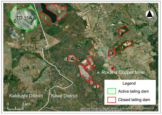
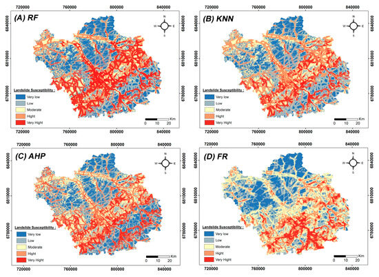
Land use land cover (LULC) changes resulting from copper exploration in Kitwe District, Copperbelt Province has adversely impacted the environment. To understand LULC change dynamics associated with mining activities, this study mapped LULC changes using the Google Earth Engine (GEE) from 1990 to
[...] Read more.
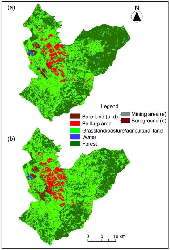
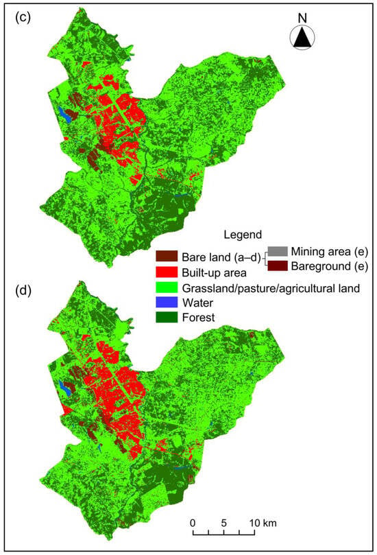
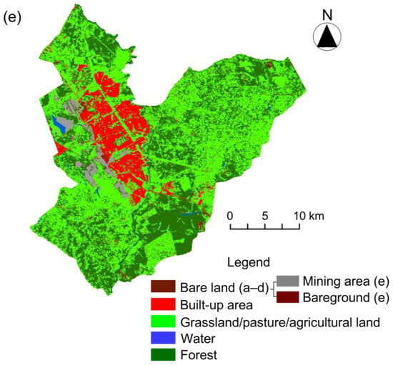
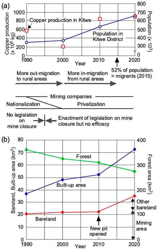
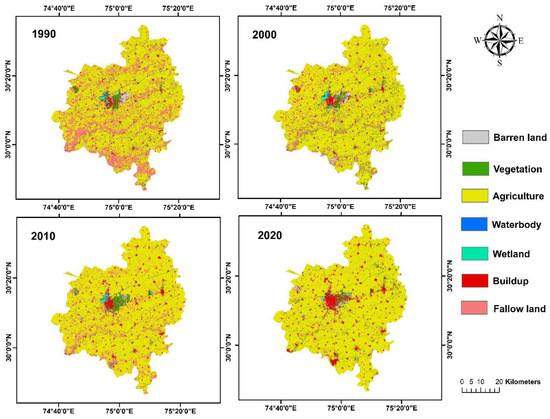
Land use land cover (LULC) changes resulting from copper exploration in Kitwe District, Copperbelt Province has adversely impacted the environment. To understand LULC change dynamics associated with mining activities, this study mapped LULC changes using the Google Earth Engine (GEE) from 1990 to 2020. In addition, the Zambian legal framework for mine closure was assessed in terms of adequacy and comprehensiveness. A remote sensing analysis using Landsat TM (1990, 2000, and 2010) and OLI (2020) images was performed and the GEE Random Forest classifier algorithm was employed to detect LULC changes. Then, transition matrices and overall changes were calculated for each LULC class. The LULC classification had an overall accuracy and kappa coefficient of 82.47% and 0.78, respectively. In total, 45.2% of the district area (360.92 km2) experienced LULC changes from 1990 to 2020. The overall change indicates that the areas of built-up area, bare land, and grassland/pasture/agricultural land gained 35.84, 14.67, and 43.53 km2, respectively, while forest lost 95.30 km2, with the major driver being the privatization of mining companies. Several concerns regarding the mine closure process practiced in Zambia have principally been raised to the government. Although the legislation generally conformed to international best practices, a gap involving various pieces of legislation, overlapping requirements, and different interpretations of the laws by different governmental departments makes the system complex and unmanageable. An area of concern is the government’s capability and competence to implement legislation. Ineffective law enforcement, that is, the inadequacy of the legislation, is to blame for LULC changes in mining areas, resulting in mining corporations not paying attention to the changes made, particularly regarding mine closures. This study provides decision-makers and land use planners with baseline knowledge on LULC changes that can be valuable for future mining legislation and how these legislations can be effectively executed to ensure sustainable mine closure.
Full article
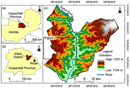
Figure 1


