
Merging Satellite Products and Rain-Gauge Observations to Improve Hydrological Simulation: A Review


Abstract
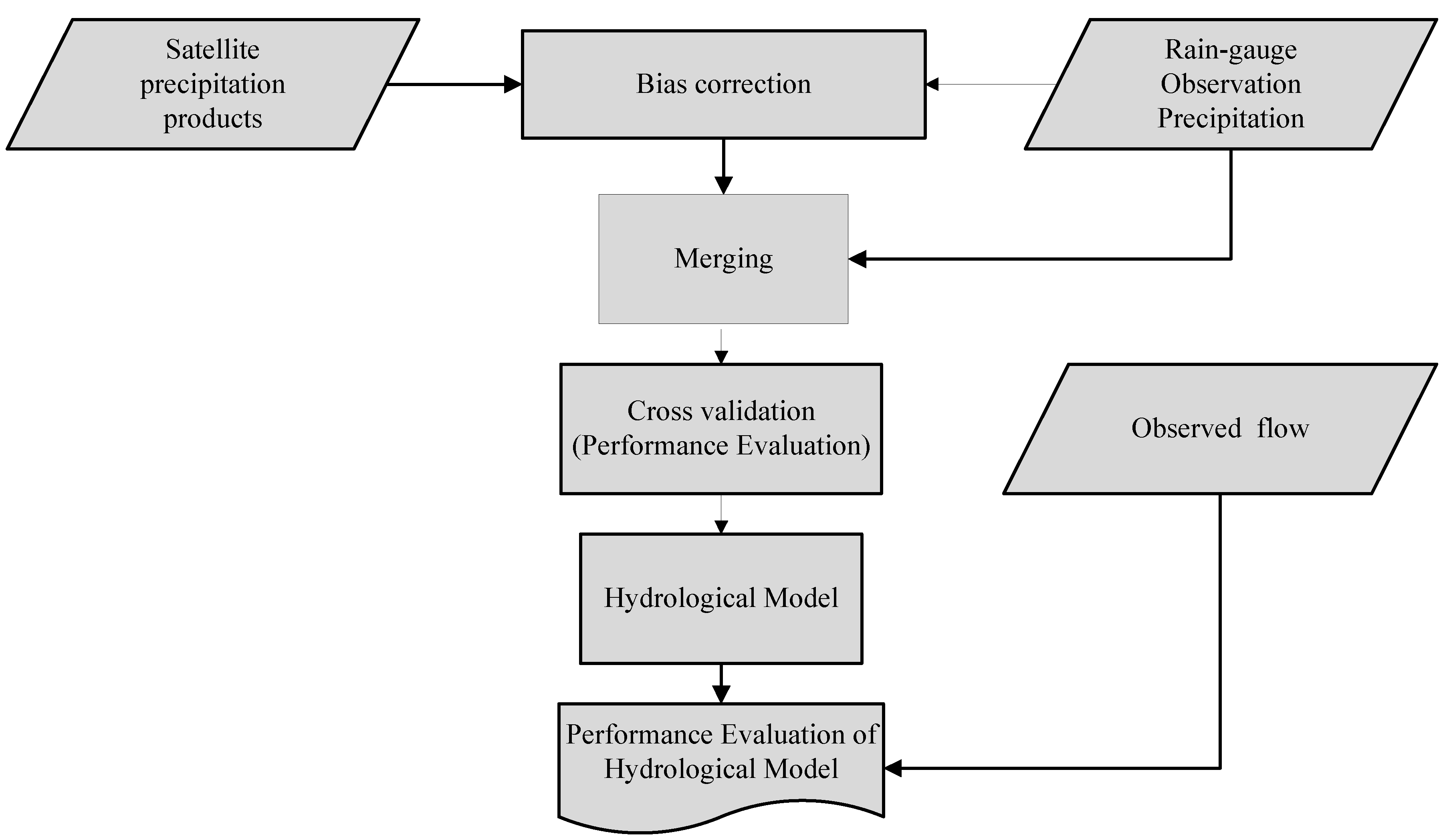
:1. Introduction
2. Satellite-Based Precipitation Products
3. Precipitation Merging Approaches
3.1. Multiple Linear Regression (MLR)
- There must be a linear relationship between the dependent (SPPs) and independent (obs) variables, which is known as the linearity property.
- The errors between obs and merged precipitation should be normally distributed.
- Independent variables (obs) are not highly correlated with each other.
- The variance of error terms is alike throughout the values of the independent variables (obs).
3.2. Residual Inverse Distance Weighting (RIDW)
3.3. Linearized Weighting (LW)
3.4. Inverse Root-Mean-Square Error (IRMSE) Weighting
3.5. Optimal Interpolation (OI)
3.6. Random-Forest-Based Merging Procedure (RF-MEP)
- Gauge obs bias is neglected; SPPs contain systematic error (bias).
- Merged precipitation products can represent spatio-temporal variability of precipitation.
- Data acquisition: This step involves acquiring datasets such as SPPs, obs, and other spatial data such as a digital elevation model (DEM).
- Data processing: This step involves resampling of selected gridded precipitation and other spatial datasets to the same spatial resolution. In addition, partitioning of gauge obs for training and validating is done in this step.
- Merging: This step involves extraction of the covariate values, training of RF using the obs, and prediction using Equation (11).where PRf is final predicted precipitation; B is the total number of trees; and xb represents each individual decision tree. Here, the decision tree is a tree-like model for representing a series of decisions along with possible outcomes.
- Performance evaluation: This is the final step of RF-MEP for cross-validation of merged precipitation with independent gauge obs.
3.7. Bayesian Model Averaging (BMA)
3.8. Kriging Method (KM)
3.9. Performance Evaluation of Merged Precipitation
4. Application of Merged Precipitation for Improved Hydrological Simulation
5. Conclusions and Future Research Directions
- Worldwide, different SPPs have been utilized in data scarce regions, un-gauged basins, and areas with complex land features. Although there is no universally accepted logic and framework for choosing SPPs for the application of merging, several researchers [14,16,46] suggested different criteria, including performance of the SPP, spatio-temporal coverage, performance of the SPPs at complex topography, and condition of the study area. Hence, researchers need to consider all the stated criteria for selecting SPPs.
- In fact, different approaches to merging offer the opportunity to overcome the overestimation, underestimation, and false alarms of SPPs. However, researchers have to select merging approaches reasonably by considering their technical aspects. Researchers are also recommended to bias-correct satellite products before merging with gauge obs to avoid systematic error using the available methods. Most of the previous studies used linear scaling, delta change correction, power transformation, distribution mapping, quantile mapping, and so on [60,70] for bias-correcting satellite products. Quantile mapping is the most recommended one because of its capability in capturing weather events [58].
- Future studies need to focus on inter-comparisons of various precipitation merging approaches for better understanding of their merits and demerits.
- In addition, most of the previous studies applied traditional statistical measures such as NSE, r, PBIAS, RMSE, FAR, and POD, among others, for cross-validation of merged precipitation with gauge obs. However, to overcome the limitations of these traditional techniques, researchers need to apply other composite methods such as the Kling–Gupta efficiency method [71]. Moreover, it is also recommended to use multi-criteria decision analysis (MCDA) methods such as Fuzzy-Order of Preference by Similarity to Ideal Solution (TOPSIS), compromise programing, and others approaches for evaluating overall performance of the merged precipitation product.
- The study, in general, shows that the investigation of appropriate satellite product and ground-based-measured precipitation merging approaches can produce improved hydro-meteorological forecasting, water resources assessment and management, and flood and drought prediction.
Author Contributions
Funding
Institutional Review Board Statement
Informed Consent Statement
Data Availability Statement
Conflicts of Interest
References
- Kumar, N.; Jha, G.K. Time Series ANN Approach for Weather Forecasting. Int. J. Control Theory Comput. Model. 2013, 3, 19–25. [Google Scholar] [CrossRef]
- Senay, G.B.; Bohms, S.; Singh, R.K.; Gowda, P.H.; Velpuri, N.M.; Alemu, H.; Verdin, J.P. Operational Evapotranspiration Mapping Using Remote Sensing and Weather Datasets: A New Parameterization for the SSEB Approach. J. Am. Water Resour. Assoc. 2013, 49, 577–591. [Google Scholar] [CrossRef] [Green Version]
- Toride, K.; Cawthorne, D.L.; Ishida, K.; Kavvas, M.L.; Anderson, M.L. Long-term trend analysis on total and extreme precipitation over Shasta Dam watershed. Sci. Total Environ. 2018, 626, 244–254. [Google Scholar] [CrossRef] [PubMed]
- Haile, A.T.; Akawka, A.L.; Berhanu, B.; Rientjes, T. Changes in water availability in the Upper Blue Nile basin under the representative concentration pathways scenario. Hydrol. Sci. J. 2017, 62, 2139–2149. [Google Scholar] [CrossRef] [Green Version]
- Tabari, H. Climate change impact on flood and extreme precipitation increases with water availability. Sci. Rep. 2020, 10, 13768. [Google Scholar] [CrossRef]
- Iyengar, A.M.; Bharat, K.U.; Divya, M. Drought Prediction Using Machine Learning. Int. J. Adv. Comput. Sci. Cloud Comput. 2019, 7, 1–6. [Google Scholar]
- Domenikiotis, C.; Dalezios, N.R. Assessment of the Cold Cloud Duration (CCD) Methodology for Rainfall Estimation in Central Greece. In Proceedings of the International Symposium, Volos, Greece, 7–9 November 2003; pp. 185–194. [Google Scholar]
- Zhu, D.; Wang, G.; Ren, Q.; Ilyas, A.M. Hydrological evaluation of hourly merged satellite–station precipitation product in the mountainous basin of China using a distributed hydrological model. Meteorol. Appl. 2020, 27, e1909. [Google Scholar] [CrossRef]
- Woldemeskel, F.M.; Sivakumar, B.; Sharma, A. Merging gauge and satellite rainfall with specification of associated uncertainty across Australia. J. Hydrol. 2013, 499, 167–176. [Google Scholar] [CrossRef]
- La Barbera, P.; Lanza, L.; Stagi, L. Tipping bucket mechanical errors and their influence on rainfall statistics and extremes. Water Sci. Technol. 2002, 45, 1–9. [Google Scholar] [CrossRef]
- Molini, A.; Lanza, L.G.; La Barbera, P. The impact of tipping-bucket raingauge measurement errors on design rainfall for urban-scale applications. Hydrol. Process. 2005, 19, 1073–1088. [Google Scholar] [CrossRef]
- Cauteruccio, A.; Brambilla, E.; Stagnaro, M.; Lanza, L.G.; Rocchi, D. Experimental evidence of the wind-induced bias of precipitation gauges using particle image velocimetry and particle tracking in the wind tunnel. J. Hydrol. 2021, 600, 126690. [Google Scholar] [CrossRef]
- Jevons, W.S. LIV. On the deficiency of rain in an elevated rain-gauge, as caused by wind. London, Edinburgh, Dublin Philos. Mag. J. Sci. 1861, 22, 421–433. [Google Scholar] [CrossRef]
- Folland, C.K. Numerical models of the raingauge exposure problem, field experiments and an improved collector design. Q. J. R. Meteorol. Soc. 1988, 114, 1485–1516. [Google Scholar] [CrossRef]
- Cauteruccio, A.; Brambilla, E.; Stagnaro, M.; Lanza, L.G.; Rocchi, D. Wind Tunnel Validation of a Particle Tracking Model to Evaluate the Wind-Induced Bias of Precipitation Measurements. Water Resour. Res. 2021, 57, e2020WR028766. [Google Scholar] [CrossRef]
- Fu, Y.; Xia, J.; Yuan, W.; Xu, B.; Wu, X.; Chen, Y.; Zhang, H. Assessment of multiple precipitation products over major river basins of China. Arch. Meteorol. Geophys. Bioclimatol. Ser. B 2016, 123, 11–22. [Google Scholar] [CrossRef]
- Chen, F.-W.; Liu, C.-W. Estimation of the spatial rainfall distribution using inverse distance weighting (IDW) in the middle of Taiwan. Paddy Water Environ. 2012, 10, 209–222. [Google Scholar] [CrossRef]
- Yang, X.; Xie, X.; Liu, D.L.; Ji, F.; Wang, L. Spatial Interpolation of Daily Rainfall Data for Local Climate Impact Assessment over Greater Sydney Region. Adv. Meteorol. 2015, 2015, 563629. [Google Scholar] [CrossRef] [Green Version]
- Zambrano-Bigiarini, M.; Nauditt, A.; Birkel, C.; Verbist, K.; Ribbe, L. Temporal and spatial evaluation of satellite-based rainfall estimates across the complex topographical and climatic gradients of Chile. Hydrol. Earth Syst. Sci. 2017, 21, 1295–1320. [Google Scholar] [CrossRef] [Green Version]
- Levizzani, V.; Amorati, R.; Meneguzzo, F. A Review of Satellite-Based Rainfall Estimation Methods. Music—Mult. Precip. Meas. Integr. Calibration Flood Forecast. 2002. Available online: https://www.researchgate.net/publication/252272255_A_Review_of_Satellite_Based_Rainfall_Estimation_Methods (accessed on 26 August 2022).
- Kidd, C.; Levizzani, V.; Laviola, S. Quantitative Precipitation Estimation from Earth Observation Satellites. Rainfall State Sci. 2013, 191, 127–158. [Google Scholar] [CrossRef]
- Dinku, T.; Hailemariam, K.; Maidment, R.; Tarnavsky, E.; Connor, S. Combined use of satellite estimates and rain gauge observations to generate high-quality historical rainfall time series over Ethiopia. Int. J. Clim. 2014, 34, 2489–2504. [Google Scholar] [CrossRef] [Green Version]
- Hu, Q.; Li, Z.; Wang, L.; Huang, Y.; Wang, Y.; Li, L. Rainfall Spatial Estimations: A Review from Spatial Interpolation to Multi-Source Data Merging. Water 2019, 11, 579. [Google Scholar] [CrossRef]
- Crow, W.T.; Huffman, G.J.; Bindlish, R.; Jackson, T.J. Improving Satellite-Based Rainfall Accumulation Estimates Using Spaceborne Surface Soil Moisture Retrievals. J. Hydrometeorol. 2009, 10, 199–212. [Google Scholar] [CrossRef] [Green Version]
- Massari, C.; Crow, W.; Brocca, L. An assessment of the performance of global rainfall estimates without ground-based observations. Hydrol. Earth Syst. Sci. 2017, 21, 4347–4361. [Google Scholar] [CrossRef] [Green Version]
- Massari, C.; Brocca, L.; Pellarin, T.; Abramowitz, G.; Filippucci, P.; Ciabatta, L.; Maggioni, V.; Kerr, Y.; Prieto, D.F. A daily 25 km short-latency rainfall product for data-scarce regions based on the integration of the Global Precipitation Measurement mission rainfall and multiple-satellite soil moisture products. Hydrol. Earth Syst. Sci. 2020, 24, 2687–2710. [Google Scholar] [CrossRef]
- Kidd, C. Satellite rainfall climatology: A review. Int. J. Clim. 2001, 21, 1041–1066. [Google Scholar] [CrossRef]
- Kidd, C.; Dawkins, E.; Huffman, G. Comparison of precipitation derived from the ecmwf operational forecast model and satellite precipitation datasets. J. Hydrometeorol. 2013, 14, 1463–1482. [Google Scholar] [CrossRef]
- Duan, Q.; Phillips, T.J. Bayesian estimation of local signal and noise in multimodel simulations of climate change. J. Geophys. Res. Atmos. 2010, 115, 1–15. [Google Scholar] [CrossRef]
- Gebregiorgis, A.; Hossain, F. How Much Can A Priori Hydrologic Model Predictability Help in Optimal Merging of Satellite Precipitation Products? J. Hydrometeorol. 2011, 12, 1287–1298. [Google Scholar] [CrossRef] [Green Version]
- Yang, Z.; Hsu, K.; Sorooshian, S.; Xu, X.; Braithwaite, D.; Zhang, Y.; Verbist, K.M.J. Merging high-resolution satellite-based precipitation fields and point-scale rain gauge measurements-A case study in Chile. J. Geophys. Res. Atmos. 2017, 122, 5267–5284. [Google Scholar] [CrossRef] [Green Version]
- Verdin, A.; Funk, C.; Rajagopalan, B.; Kleiber, W. Kriging and Local Polynomial Methods for Blending Satellite-Derived and Gauge Precipitation Estimates to Support Hydrologic Early Warning Systems. IEEE Trans. Geosci. Remote. Sens. 2016, 54, 2552–2562. [Google Scholar] [CrossRef]
- Baez-Villanueva, O.M.; Zambrano-Bigiarini, M.; Beck, H.E.; McNamara, I.; Ribbe, L.; Nauditt, A.; Birkel, C.; Verbist, K.; Giraldo-Osorio, J.D.; Thinh, N.X. RF-MEP: A novel Random Forest method for merging gridded precipitation products and ground-based measurements. Remote. Sens. Environ. 2020, 239, 111606. [Google Scholar] [CrossRef]
- Brocca, L.; Massari, C.; Pellarin, T.; Filippucci, P.; Ciabatta, L.; Camici, S.; Kerr, Y.H.; Fernández-Prieto, D. River flow prediction in data scarce regions: Soil moisture integrated satellite rainfall products outperform rain gauge observations in West Africa. Sci. Rep. 2020, 10, 12517. [Google Scholar] [CrossRef]
- Arkin, P.; Meisner, B.N. The Relationship between Large-Scale Convective Rainfall and Cold Cloud over the Western Hemisphere during 1982–1984. Mon. Weather. Rev. 1987, 115, 51–74. [Google Scholar] [CrossRef]
- Manz, B.; Buytaert, W.; Zulkafli, Z.; Lavado, W.; Willems, B.; Robles, L.A.; Rodríguez-Sánchez, J. High-resolution satellite-gauge merged precipitation climatologies of the Tropical Andes. J. Geophys. Res. Atmos. 2016, 121, 1190–1207. [Google Scholar] [CrossRef] [Green Version]
- Berg, W.; Olson, W.; Ferraro, R.; Goodman, S.J.; Lafontaine, F.J. An Assessment of the First- and Second-Generation Navy Operational Precipitation Retrieval Algorithms. J. Atmos. Sci. 1998, 55, 1558–1575. [Google Scholar] [CrossRef]
- Nativi, S.; Barrett, E.; Beaumont, M. Monitoring of rainfall integrating active and passive microwave sensors: Possibilities and problems. Phys. Chem. Earth 1997, 22, 229–233. [Google Scholar] [CrossRef]
- Ushio, T.; Sasashige, K.; Kubota, T.; Shige, S.; Okamoto, K.; Aonashi, K.; Inoue, T.; Takahashi, N.; Iguchi, T.; Kachi, M.; et al. A Kalman Filter Approach to the Global Satellite Mapping of Precipitation (GSMaP) from Combined Passive Microwave and Infrared Radiometric Data. J. Meteorol. Soc. Jpn. 2009, 87, 137–151. [Google Scholar] [CrossRef] [Green Version]
- Dinku, T.; Ruiz, F.; Connor, S.J.; Ceccato, P. Validation and Intercomparison of Satellite Rainfall Estimates over Colombia. J. Appl. Meteorol. Clim. 2010, 49, 1004–1014. [Google Scholar] [CrossRef]
- Ringard, J.; Seyler, F.; Linguet, L. A Quantile Mapping Bias Correction Method Based on Hydroclimatic Classification of the Guiana Shield. Sensors 2017, 17, 1413. [Google Scholar] [CrossRef] [Green Version]
- Joyce, R.J.; Janowiak, J.E.; Arkin, P.A.; Xie, P. CMORPH: A method that produces global precipitation estimates from passive microwave and infrared data at high spatial and temporal resolution. J. Hydrometeorol. 2004, 5, 487–503. [Google Scholar] [CrossRef]
- Sorooshian, S.; Hsu, K.-L.; Gao, X.; Gupta, H.V.; Imam, B.; Braithwaite, D. Evaluation of PERSIANN System Satellite–Based Estimates of Tropical Rainfall. Bull. Am. Meteorol. Soc. 2000, 81, 2035–2046. [Google Scholar] [CrossRef]
- Hong, Y.; Hsu, K.-L.; Sorooshian, S.; Gao, X. Precipitation Estimation from Remotely Sensed Imagery Using an Artificial Neural Network Cloud Classification System. J. Appl. Meteorol. 2004, 43, 1834–1853. [Google Scholar] [CrossRef] [Green Version]
- Huffman, G.J.; Bolvin, D.T.; Nelkin, E.J.; Wolff, D.B.; Adler, R.F.; Gu, G.; Hong, Y.; Bowman, K.P.; Stocker, E.F. The TRMM Multisatellite Precipitation Analysis (TMPA): Quasi-Global, Multiyear, Combined-Sensor Precipitation Estimates at Fine Scales. J. Hydrometeorol. 2007, 8, 38–55. [Google Scholar] [CrossRef]
- Knapp, K.; Ansari, S.A.; Bain, C.L.; Bourassa, M.A.; Dickinson, M.J.; Funk, C.; Helms, C.; Hennon, C.C.; Holmes, C.; Huffman, G.; et al. Globally Gridded Satellite Observations for Climate Studies. Bull. Am. Meteorol. Soc. 2011, 92, 893–907. [Google Scholar] [CrossRef]
- Funk, C.; Peterson, P.; Landsfeld, M.; Pedreros, D.; Verdin, J.; Shukla, S.; Husak, G.; Rowland, J.; Harrison, L.; Hoell, A.; et al. The climate hazards infrared precipitation with stations—A new environmental record for monitoring extremes. Sci. Data 2015, 2, 1–21. [Google Scholar] [CrossRef] [Green Version]
- Ashouri, H.; Nguyen, P.; Thorstensen, A.; Hsu, K.-L.; Sorooshian, S.; Braithwaite, D. Assessing the Efficacy of High-Resolution Satellite-Based PERSIANN-CDR Precipitation Product in Simulating Streamflow. J. Hydrometeorol. 2016, 17, 2061–2076. [Google Scholar] [CrossRef]
- Huffman, G.J.; Adler, R.F.; Morrissey, M.M.; Bolvin, D.T.; Curtis, S.; Joyce, R.; McGavock, B.; Susskind, J. Global Precipitation at One-Degree Daily Resolution from Multisatellite Observations. J. Hydrometeorol. 2001, 2, 36–50. [Google Scholar] [CrossRef]
- Fan, Z.; Li, W.; Jiang, Q.; Sun, W.; Wen, J.; Gao, J. A Comparative Study of Four Merging Approaches for Regional Precipitation Estimation. IEEE Access 2021, 9, 33625–33637. [Google Scholar] [CrossRef]
- Uyanık, G.K.; Güler, N. A Study on Multiple Linear Regression Analysis. Procedia Soc. Behav. Sci. 2013, 106, 234–240. [Google Scholar] [CrossRef] [Green Version]
- Porter, A.; Connolly, T.; Heikes, R.G.; Park, C.Y. Misleading indicators: The limitations of multiple linear regression in formulation of policy recommendations. Policy Sci. 1981, 13, 397–418. [Google Scholar] [CrossRef]
- Adhikary, S.K.; Muttil, N.; Yilmaz, A.G. Cokriging for enhanced spatial interpolation of rainfall in two Australian catchments. Hydrol. Process. 2017, 31, 2143–2161. [Google Scholar] [CrossRef]
- Wu, Z.; Zhang, Y.; Sun, Z.; Lin, Q.; He, H. Improvement of a combination of TMPA (or IMERG) and ground-based precipitation and application to a typical region of the East China Plain. Sci. Total Environ. 2018, 640–641, 1165–1175. [Google Scholar] [CrossRef] [PubMed]
- Nie, S.; Wu, T.; Luo, Y.; Deng, X.; Shi, X.; Wang, Z.; Liu, X.; Huang, J. A strategy for merging objective estimates of global daily precipitation from gauge observations, satellite estimates, and numerical predictions. Adv. Atmos. Sci. 2016, 33, 889–904. [Google Scholar] [CrossRef]
- Themeßl, M.J.; Gobiet, A.; Heinrich, G. Empirical-statistical downscaling and error correction of regional climate models and its impact on the climate change signal. Clim. Chang. 2012, 112, 449–468. [Google Scholar] [CrossRef]
- Ma, Y.; Hong, Y.; Chen, Y.; Yang, Y.; Tang, G.; Yao, Y.; Long, D.; Li, C.; Han, Z.; Liu, R. Performance of Optimally Merged Multisatellite Precipitation Products Using the Dynamic Bayesian Model Averaging Scheme Over the Tibetan Plateau. J. Geophys. Res. Atmos. 2018, 123, 814–834. [Google Scholar] [CrossRef] [Green Version]
- Li, M.; Shao, Q. An improved statistical approach to merge satellite rainfall estimates and raingauge data. J. Hydrol. 2010, 385, 51–64. [Google Scholar] [CrossRef]
- Mekonnen, K.; Melesse, A.M.; Woldesenbet, T.A. Merging satellite rainfall estimates and daily rain gauge observations for improved flood simulation in MelkaKuntire catchment, upper Awash Basin, Ethiopia. Remote Sens. Appl. Soc. Environ. 2022, 25, 100701. [Google Scholar] [CrossRef]
- Zhu, Q.; Gao, X.; Xu, Y.-P.; Tian, Y. Merging multi-source precipitation products or merging their simulated hydrological flows to improve streamflow simulation. Hydrol. Sci. J. 2019, 64, 910–920. [Google Scholar] [CrossRef]
- Ibrahim, A.H.; Molla, D.D.; Lohani, T.K. Performance evaluation of satellite-based rainfall estimates for hydrological modeling over Bilate river basin, Ethiopia. World J. Eng. 2022. ahead of print. [Google Scholar] [CrossRef]
- Beck, H.E.; Vergopolan, N.; Pan, M.; Levizzani, V.; van Dijk, A.I.J.M.; Weedon, G.P.; Brocca, L.; Pappenberger, F.; Huffman, G.J.; Wood, E.F. Global-Scale Evaluation of 22 Precipitation Datasets Using Gauge Observations and Hydrological Modeling. Adv. Glob. Chang. Res. 2020, 69, 625–653. [Google Scholar] [CrossRef]
- Yoshimoto, S.; Amarnath, G. Applications of Satellite-Based Rainfall Estimates in Flood Inundation Modeling—A Case Study in Mundeni Aru River Basin, Sri Lanka. Remote Sens. 2017, 9, 998. [Google Scholar] [CrossRef]
- Maggioni, V.; Massari, C. On the performance of satellite precipitation products in riverine flood modeling: A review. J. Hydrol. 2018, 558, 214–224. [Google Scholar] [CrossRef]
- Rozante, J.R.; Moreira, D.S.; De Goncalves, L.G.; Vila, D.A. Combining TRMM and surface observations of precipitation: Technique and validation over South America. Am. Meteorol. Soc. 2010, 25, 885–894. [Google Scholar] [CrossRef] [Green Version]
- Shawky, M.; Moussa, A.; Hassan, Q.K.; El-Sheimy, N. Performance Assessment of Sub-Daily and Daily Precipitation Estimates Derived from GPM and GSMaP Products over an Arid Environment. Remote Sens. 2019, 11, 2840. [Google Scholar] [CrossRef] [Green Version]
- Liu, X.; Liu, F.M.; Wang, X.X.; Li, X.D.; Fan, Y.Y.; Cai, S.X.; Ao, T.Q. Combining rainfall data from rain gauges and TRMM in hydrological modelling of Laotian data-sparse basins. Appl. Water Sci. 2017, 7, 1487–1496. [Google Scholar] [CrossRef] [Green Version]
- Min, X.; Yang, C.; Dong, N. Merging Satellite and Gauge Rainfalls for Flood Forecasting of Two Catchments Under Different Climate Conditions. Water 2020, 12, 802. [Google Scholar] [CrossRef] [Green Version]
- Chiang, Y.-M.; Hsu, K.-L.; Chang, F.-J.; Hong, Y.; Sorooshian, S. Merging multiple precipitation sources for flash flood forecasting. J. Hydrol. 2007, 340, 183–196. [Google Scholar] [CrossRef] [Green Version]
- Ly, S.; Charles, C.; Degré, A. Geostatistical interpolation of daily rainfall at catchment scale: The use of several variogram models in the Ourthe and Ambleve catchments, Belgium. Hydrol. Earth Syst. Sci. 2011, 15, 2259–2274. [Google Scholar] [CrossRef] [Green Version]
- Gupta, H.V.; Kling, H.; Yilmaz, K.K.; Martinez, G.F. Decomposition of the mean squared error and NSE performance criteria: Implications for improving hydrological modelling. J. Hydrol. 2009, 377, 80–91. [Google Scholar] [CrossRef]


| Short Name | Full Name and Web Source | Spatial/Temporal Resolution | Coverage | Data Availability | Reference |
|---|---|---|---|---|---|
| CMORPH V1 | CPC MORPHing technique V1:(https://www.cpc.ncep.noaa.gov/, accessed on 10 August 2022) | 0.25°/3 h | 60° S–60° N | 1998–present | [42] |
| PERSIANN | Precipitation Estimation from Remotely Sensed Information using Artificial Neural Networks (PERSIANN): (http://chrs.web.uci.edu/, accessed on 10 August 2022) | 0.25°/6 h | 60°S–60° N | 2000–present | [43] |
| PERSIANN-CCS | Precipitation Estimation from Remotely Sensed Information using Artificial Neural Networks Cloud Classification System:(http://chrs.web.uci.edu/, accessed on:10 August 2022) | 0.04°/30 min | 60 °S–60° N | 2003–present | [44] |
| GSMaP-MVK V5/6 | Global Satellite Mapping of Precipitation Moving Vector with Kalman standard V5 and V6: (https://sharaku.eorc.jaxa.jp/GSMaP/, accessed on:15 August 2022) | 0.10°/1 h | 60° S–60° N | 2000–present | [39] |
| TMPA-3B42RT V7 | TRMM Multi-satellite Precipitation Analysis (TMPA) 3B42RT V7: (https://mirador.gsfc.nasa.gov/, accessed on:15 August 2022) | 0.25°/3 r | 50° S–50° N | 1998–2015 | [45] |
| GridSat V1.0 | Precipitation derived from the Gridded Satellite (GridSat) B1 thermal infrared archive v02r01:(https://www.ncdc.noaa.gov/gridsat/, accessed on:15 August 2022) | 0.1°/3 h | 50° S–50° N | 1983–2016 | [46] |
| CHIRP V2.0 | Climate Hazards group Infrared Precipitation (CHIRP) V2.0 (http://chg.ucsb.edu/data/chirps/, accessed on:10 August 2022) | 0.05°/daily | Land, 50° S–50° N | 1981–present | [47] |
| CHIRPS V2.0 | Climate Hazards group Infrared Precipitation with Stations V2.0: (http://chg.ucsb.edu/data/chirps/, accessed on:25 August 2022) | 0.07°/daily | Land, 50° S–50° N | 1981–present | [47] |
| PERSIANN-CDR | Precipitation Estimation from Remotely Sensed Information using Artificial Neural Networks (PERSIANN) Climate Data Record (CDR) V1R1: (http://chrs.web.uci.edu/, accessed on:19 August 2022) | 0.07°/6 h | 60° S–60° N | 1983–2016 | [48] |
| TMPA 3B42 V7 | TRMM Multi-satellite Precipitation Analysis (TMPA) 3B42 V7: (https://mirador.gsfc.nasa.gov/, accessed on:10 August 2022) | 0.07°/3 h | 50° S–50° N | 2000–2017 | [45] |
| PERSIANN-CDR | Precipitation Estimation from Remotely Sensed Information using Artificial Neural Networks Climate Data Record.2: (http://chrs.web.uci.edu/, accessed on:10 August 2022) | 1°/daily | Gl°bal | 1996–2015 | [49] |
| Type of Measurement | Performance Measurement Metrics | Description | Mathematical Formula | Dimension, Range | Optimal Value |
|---|---|---|---|---|---|
| Continuous | Pearson Correlation Coefficient (r) | Quantifies the strength of the relationship between the gauge obs and the merged precipitation product | ND, −1 to 1 | 1 | |
| Percent Bias (PBIAS) | Evaluates the average tendency of the merged precipitation product | × 100 | Percent (%), −∞ to +∞) | 0 | |
| Root Mean Square (RMSE) | Measures the absolute mean difference between gauge obs and the merged precipitation product | mm, 0, to +∞ | 0 | ||
| Nash–Sutcliffe Efficiency (NSE) | Measures the accuracy of the merged precipitation product corresponding to the mean gauge obs | ND, −∞ to 1 | 1 | ||
| Relative Mean Absolute Error (RMAE) | Measures the average magnitude of the merged precipitation error | ND, [0, +∞) | 0 | ||
| Mean error (ME) | Indicates average error of the merged precipitation product | mm, −∞ to +∞ | 0 | ||
| Bias | Evaluates how well the merged and the mean gauge obs precipitation correspond | ND, 0 to +∞, | 1 | ||
| Categorical | Probability of Detection (POD) | Measures the fraction of the gauge obs that is correctly detected by the merged precipitation product | ND, 0 to 1; | 1 | |
| False Alarm Ratio (FAR) | Measures the portion of the precipitation event which is detected by the merged product but not identified by the gauge obs | ND, 0 to 1; | 0 | ||
| Critical Success Index (CSI) | Identifies the overall skill of the merged precipitation product relative to the gauge obs | ND, 0 to 1; | 1 | ||
| Frequency Bias (FB) | Finds the systematic differences between precipitation event frequencies in the gauge obs and merged precipitation product | ND, 0 to 1 | 1 |
| Study Area | Satellite Precipitation Product | Hydrological Model | Summary of Method and Finding | Author |
|---|---|---|---|---|
| Melkakuntire catchment, Ethiopia | TRMM 3B42v7, IMERG v06B 0.1, TAMSAT v3 | HBV-light |
RF-MEP was employed for merging; The study evaluated the suitability of merged and un-merged (raw) precipitation at the daily and seasonal scale for improved flood simulation; Merged precipitation produced better results for estimation of the water budget of the study area. | [59] |
| Nam Khan River basin, China | TRMM 3B42 V7 | BTOPMC |
The study evaluated the performance bias of corrected TRMM precipitation and merged (gauge obs and TRMM) precipitation using a semi-distributed hydrological model at the daily scale; In the study, the merged precipitation product results had better performance in terms of NSE and volumetric ratio (Vr) than the individual precipitation product during the calibration and validation stage. | [67] |
| Xin’an and Wuding River catchment | TRMM 3B42RT, TRMM 3B42V7, GPM IMERG | HEC-HMS |
For merging, correction index which is ratio of the obs precipitation to the satellite precipitation was calculated for each grid at each time step; The study compared streamflow simulated by a semi-distributed hydrological model using individual and merged precipitation products for flood forecasting; The performance matrixes, such as CC, RMSE, and MAE, were improved when merged precipitation was used as input for the hydrological model (HEC-HMS). | [68] |
| Wu-Tu catchment, Taiwan | PERSIANN CCS | RNN |
The linear weighting method was applied to merge the SPP and gauge obs for flash flood forecasting; The model performance matrixes (RMSE, CC, MAE) were improved when the merged precipitation product was used as input for the RNN model. | [69] |
| Xiang River Basin |
TRMM 3B42 V7), PERSIANN-CDR, NCEP-CFSR | SWAT |
BMA was used to merge SPPs products for streamflow simulations; The erged precipitation product produced better results. | [60] |
Publisher’s Note: MDPI stays neutral with regard to jurisdictional claims in published maps and institutional affiliations. |
© 2022 by the authors. Licensee MDPI, Basel, Switzerland. This article is an open access article distributed under the terms and conditions of the Creative Commons Attribution (CC BY) license (https://creativecommons.org/licenses/by/4.0/).
Share and Cite
Belay, H.; Melesse, A.M.; Tegegne, G. Merging Satellite Products and Rain-Gauge Observations to Improve Hydrological Simulation: A Review. Earth 2022, 3, 1275-1289. https://doi.org/10.3390/earth3040072
Belay H, Melesse AM, Tegegne G. Merging Satellite Products and Rain-Gauge Observations to Improve Hydrological Simulation: A Review. Earth. 2022; 3(4):1275-1289. https://doi.org/10.3390/earth3040072
Chicago/Turabian StyleBelay, Haile, Assefa M. Melesse, and Getachew Tegegne. 2022. "Merging Satellite Products and Rain-Gauge Observations to Improve Hydrological Simulation: A Review" Earth 3, no. 4: 1275-1289. https://doi.org/10.3390/earth3040072