Proceeding Paper

High Precision Indoor Positioning System for Mobile Asset Management and Safety †

1
Smart City Lab, National Center of Artificial Intelligence, Computer & Information Systems Department, NED University of Engineering & Technology, Karachi 75270, Pakistan
2
Electrical, Computer and Biomedical Engineering Department, College of Engineering, Abu Dhabi University, Abu Dhabi 59911, United Arab Emirates
*
Author to whom correspondence should be addressed.
Presented at the 7th International Electrical Engineering Conference, Karachi, Pakistan, 25–26 March 2022.
Eng. Proc. 2022, 20(1), 37; https://doi.org/10.3390/engproc2022020037
Published: 5 August 2022
(This article belongs to the Proceedings of The 7th International Electrical Engineering Conference)

Abstract

:
Locating a dynamic object in an industrial environment in real time has been a significant scientific problem. The precise localization and positioning of an object are achieved by Satellite communication, Wireless Fidelity (WiFi), Bluetooth technologies, etc. The use of the Global Positioning System (GPS) has been a success for locating an object in an outdoor environment, but indoor positioning has been impractical when using this technology. A good option is to utilize short-range Ultra Wide Band (UWB) technology with Time of Flight, Time Difference of Arrival, and Phase difference of Arrival methods for precise ranging applications. In this research paper, we presented an accurate indoor positioning system using a UWB radio-based embedded system. The system deployed multiple fixed positioning stations called anchors, programmed to detect the position of the dynamic object. The presented system in this paper calculates the object position by using the Time Difference of Arrival (TDOA) method and the triangulation method. The Indoor Positioning System (IPS) is found to effectively locate the dynamic object in three-dimensional space within an error rate of +/−0.07 m.

1. Introduction

Today, there are numerous tracking systems available through GPS, RFID [1], Barcode, and Global Trade Item Number (GTIN) [2]. These are the techniques used in current scenarios. Cutting-edge innovations or instruments are needed to handle such circumstances in the coordination channel for effective creation measures. Real-time tracking has been a challenge for the revolutionizing world, especially in indoor environments. The widely used GPS keeps track of remote objects in outdoor environments in a precise way, but tracking indoor devices, usually in basements, is still burdensome. The Indoor Positioning System (IPS) is the solution to this problem as it determines objects’ positions [3]. Indoor environments consist of obstacles having different shapes, sizes, and areas that become a hurdle for the signal propagation between transmitter and receiver devices. Mul tiple objects or persons must be located by the system in an enclosed environment, so the chance of interference and signal losses is high. Therefore, the precision and robustness of the system are needed to tackle such challenges. It is possible to detect and take appropriate steps in many different situations through the implementation of GPS in the logistics chain, where needed solutions resolve crucial problems or at least reduce the damage [4]. This framework is likewise considered as a helpful prerequisite for worldwide transportation ventures [5,6]. The core objective of the study is to design a high-precision indoor positioning system determining the location of remote devices and displaying their position on a map. IPS is like a GPS for indoor environments, used to precisely locate objects and people in an enclosed environment [7]. In this section, we present the necessary information that researchers might consider before initiating the topic of indoor positioning systems and environments.

1.1. Type of Positioning

This portion focuses on two types of positioning techniques which are positioning objects and positioning users. The first type consists of RFID or any other tools carried by the users in an introduced situating framework inside the structure and is dependent on the remote sensor network utilized in the framework, known as a Fixed Indoor Positioning System. In the second kind, clients convey the gear, for example RFID, and there is no framework introduced in the structure inside that given environment, and this is known as pedestrian positioning [8]. The need for four principles that help in building positioning systems includes: Trilateration, which defines the address of one unknown point with the help of the three known points; Triangulation, a method which computes the distance based on the enumeration of angles; Scene Analysis, which uses fingerprinting for positioning purposes [9]; and Proximity, a technique that is basically dependent upon frequency-based systems [10].

1.2. Industrial Use Cases

There are numerous applications of the proposed IPS solution, such as in industries, shopping malls, transportation hubs, etc. Some of the tasks achieved through IPS include asset tracking and indoor navigation, indoor positioning of cars in the showroom, workers’ safety in warehouses, asset and personnel tracking and tunneling, the tracing of personnel in disasters, etc. This enables the massive market covering the IPS to be cost-effective and precise.

1.3. Techniques of Indoor Positioning

Several techniques can be implemented to locate the object in an indoor environments, such as:
  • RSS: This technique is purely dependent on the signal strength of the system. The transmitter 1 transmits the radio signal received by the receiver, which provides the approximation of an object. However, this technique is not suitable where high accuracy is required.
  • TOF: This system focuses on radio signal propagation sent from the transmitter for the flight time to the receiver. This appropriate method works smoothly because the speed of radio waves in the air is known.
  • TDOA: In TDOA, three or more anchors are placed on known locations, and these anchors are time-synchronized, as shown in Figure 1.
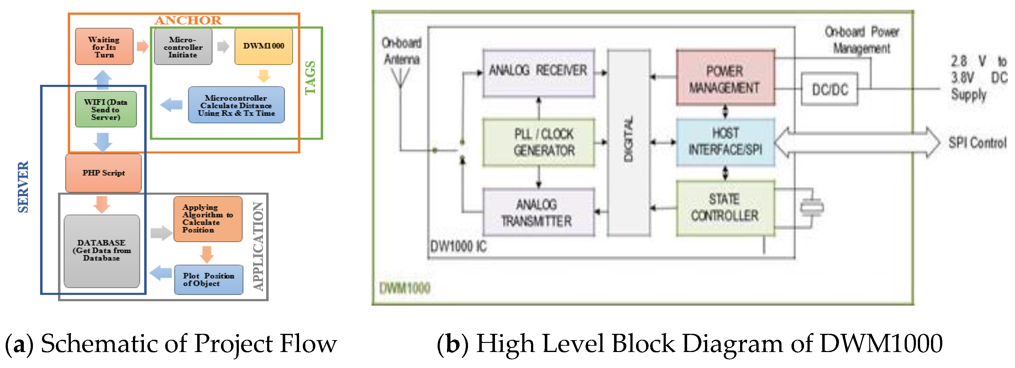
2. Methodology

This section covers a detailed explanation of the methodology and is depicted in Figure 2a,b. The indoor positioning system is developed by calculating the distance of the remote object using UWB technology and WiFi for wireless communication. We built the hardware gadget using the micro-controller as a master to control all the UWB and WiFi communication.

2.1. Design the Solution

A modular design approach designs the overall solution of the project. Different schematics and layouts are depicted to complete the hardware requirements. Anchors, such as fixed objects, and tags, such as movable objects, are deployed.
The DWM1000 is an IEEE802.15.4-2011 UWB consistent remote handset module dependent on Decawave’s DW1000 IC. It enhances the accuracy of locating the object within 10 cm dia area of interest, and it includes high information rate interchanges of up to 6.8 Mbps as well as a phenomenal correspondences scope of up to 300 m on account of rational beneficiary strategies. The DecaWave Module DWM1000 is upgraded for incomparable indoor exactness areas, and Real Time Location Systems (RTLS) and Wireless Sensor Networks (WSN) are necessary for information interchanges. It is utilized for a vast scope, containing an assortment of business sectors. The key highlights are [11,12]:
  • Integration of DW1000 IC, powering the executives, radio wire, clock control to disentangle plane reconciliation
  • Allows simple joining with a wide scope of MCUs
  • Supports 110 kbps, 850 kbps and 6.8 Mbps information rates
  • Frequency of 3.5 GHz–6.5 GHz—channels 1, 2, 3, 4, 5, 7
  • 23 mm × 13 mm × 2.9 mm 24-pin side castellations
  • Supports ToF and TDoA area planes
The high-level block diagram of DWM1000 is explained in detail in Figure 2b, where different components receive and send signals from tags and anchors devices.

2.2. Object Tracking

To calculate the distance from the remote object, we placed the three stationary anchors from the secluded tag by exchanging the messages. Then, it sends the information to the server through WiFi, as shown in Figure 2b. The background service on the server gets the updated distances of the anchors and applies the mathematical model to find the location of the remote tag. According to the environment, it shows the location of the tag to the user. After that, it sends the information to the server through WiFi. This continuous cycle persistently updates the distances from the anchors of the tags on the database.
Applying Trilateration Formula:
(ra)2 − (rb)2
(ra)2 − (rc)2
The Trilateration equation above is implemented with the help of the C++ language for distance calculation. It is apparently found to be an appropriate option to implement extensive procedures in order to manipulate and compute real-world values. Moreover, the embedded coding of the WiFi module esp8266 is conducted in the same language to provide the system with wireless communication between the anchors and the server. The Arduino IDE provides a platform to develop the embedded code that resides inside the microcontroller Atmega328p. PHP is used to implement the “String query” method on the server side in order to retrieve information. Then, that information is relayed to MySQL in order to be saved in the database [13,14,15]. Python and OpenCV facilitate, in conjunction, the development of the GUI in order to display the located items. Figure 3a,b shows the pictorial representation of a map of the research lab; two circles, blue and green, illustrate the tag and the anchors, respectively, while the circles show the real-time location of the tracked objects. The visualized items on a map show close-to-original pictures of the located objects at a position. Now, find out the distances d1, d2 and d3 from an object lying at point (x,y) to the anchor tags (a,b), (c,d) and (e,f), respectively, assuming the following coordinates of anchor tags as (a,b) = (0,0), (c,d) = (6,0) and (e,f) = (0,10). The distance between the coordinates (x,y) and (a,b) is:
d2 = (xa)2 + (yb)2
= (x − 0)2 + (y − 0)2
= x2 + y2
Then, the distance between the coordinates (x,y) and (c,d) is:
d2 = (xc)2 + (yd)2
= (x − 6)2 + (y − 0)2
= x2 − 12x + 36 + y2
= x2 + y2 − 12x + 36
Now, the distance between the coordinates (x,y) and (e,f) is:
d2 = (xe)2 + (yf)2
= (x − 0)2 + (y − 10)2
= x2 + y2 − 20y + 100
By placing all the values at their respective positions in the above formulae, the coordinates of an object (x,y) = (4,6), in this example.

2.3. Testing

Testing was conducted to check the robustness, modularity and efficiency of the system. System performance testing plays a vital role in finding accuracy. Mainly, synchronizing the server side with the hardware was a nail-biter, as it involved several platforms and their syntax and dependencies. Framing through state-of-the-art techniques facilitates in developing a system that is to be tested rigorously.

2.4. Comparison between WiFi Device and DecaWave

A BLE device, a Wi-Fi device, and a DecaWave module simultaneously measure the distance of an object from the fixed point. The graphs show the differences in the accuracy of these techniques. The most accurate readings belong to the DecaWave module. The most accurate of the three techniques is the DecaWave, and the worse technique is the BLE.

3. Conclusions

Dynamic object tracking in indoor settings has posed a crucial scientific problem. It includes numerous applications where it can be implemented in various locations for moving objects’ indoor localization. The study concluded that our developed indoor positioning system’s results are better compared with other technology, and the comparison is provided in Table 1. UWB radio-based embedded systems technology provides a much better accuracy than WiFi for basements and closed environments. In addition, the associated hardware used in this study were wireless anchors and wireless tags, onboard controller program files to make the hardware work as wireless anchors or wireless tags, and offline executable files to track the monitored devices locally. The position of the movable tags was calculated by using triangulation and the TDOA approach with meter-level accuracy.

Author Contributions

Conceptualization, M.K., Methodology, L.U.Z. and H.S.F., Software Development, H.S.F., Validation, L.U.Z., Formal Analysis, L.U.Z. and M.K., Hardware Gadget, L.U.Z., Original Draft Preparation, H.S.F., Supervision, M.K., Review, H.Z. and Editing, H.S.F. All authors have read and agreed to the published version of the manuscript.

Funding

This research received no external funding.

Institutional Review Board Statement

Not applicable.

Informed Consent Statement

Informed consent was obtained from all subjects involved in the study.

Data Availability Statement

Not applicable.

Conflicts of Interest

The authors declare no conflict of interest.

References

  1. Alarifi, A.; Al-Salman, A.; Alsaleh, M.; Alnafessah, A.; Al-Hadhrami, S.; Al-Ammar, M.A.; Al-Khalifa, H.S. Ultra Wideband Indoor Positioning Technologies: Analysis and Recent Advances. Sensors 2016, 16, 707. [Google Scholar] [CrossRef] [PubMed]
  2. Fallah, N.; Apostolopoulos, I.; Bekris, K.; Folmer, E. Indoor Human Navigation Systems: A Survey. Interact. Comput. 2013, 25, 21–33. [Google Scholar]
  3. Kunhoth, J.; Karkar, A.; Al-Maadeed, S.; Al-Ali, A. Indoor positioning and wayfinding systems: A survey. Hum. Cent. Comput. Inf. Sci. 2020, 10, 1–41. [Google Scholar] [CrossRef]
  4. Li, W.; Chen, Z.; Gao, X.; Liu, W.; Wang, J. Multimodel framework for indoor localization under mobile edge computing environment. IEEE Internet Things J. 2018, 6, 4844–4853. [Google Scholar] [CrossRef]
  5. Satan, A. Bluetooth-based indoor navigation mobile system. In Proceedings of the 19th International Carpathian Control Conference (ICCC), Szilvasvarad, Hungary, 28–31 May 2018. [Google Scholar]
  6. Satan, A.; Toth, Z. Development of Bluetooth based indoor positioning application. In Proceedings of the 2018 IEEE International Conference on Future IoT Technologies, Eger, Hungary, 18–19 January 2018. [Google Scholar]
  7. Blankenbach, J.; Norrdine, A. Position Estimation using artificial generated magnetic fields. In Proceedings of the International Conference on Indoor Positioning and Indoor Navigation (IPIN), Zurich, Switzerland, 15 September 2010. [Google Scholar]
  8. Nuaimi, K.A.; Kamel, H. A Survey of Indoor Positioning Systems and Algorithms. In Proceedings of the International Conference on Innovations in Information Technology, Abu Dhabi, United Arab Emirates, 25 April 2011. [Google Scholar]
  9. Mao, G.; Fidan, B.; Anderson, B.D. Wireless sensor network localization techniques. Comput. Netw. 2007, 51, 2529–2553. [Google Scholar] [CrossRef] [Green Version]
  10. Zhang, D.; Xia, F.; Yang, Z.; Yao, L. Localization Technologies for Indoor Human Tracking. In Proceedings of the 5th International Conference on Future Information Technology, Busan, Korea, 21–23 May 2010. [Google Scholar]
  11. Amundson, I.; Koutsoukos, X.D. A Survey on Localization for Mobile Wireless Sensor Networks. In Proceedings of the International Workshop on Mobile Entity Localization and Tracking in GPS-Less Environments, Orlando, FL, USA, 30 September 2009; pp. 235–254. [Google Scholar]
  12. Maneerat, K.; Kaemarungsi, K. Performance Improvement Design of Bluetooth Low Energy-Based Wireless Indoor Positioning Systems. Mob. Inf. Syst. 2020, 2020, 18. [Google Scholar] [CrossRef]
  13. Kouyoumdjieva, S.T.; Karlsson, G. Experimental Evaluation of Precision of a Proximity-based Indoor Positioning System. In Proceedings of the 15th Annual Conference on Wireless On-Demand Network Systems and Services (WONS), Wengen, Switzerland, 22–24 January 2019. [Google Scholar]
  14. decaWave. DW1000 User Manual—How to Use, Configure and Program the DW1000 UWB Transceiver; decaWave: Greensboro, NC, USA, 2015. [Google Scholar]
  15. decaWave. APS003 Application Note Real Time Location Systems—An Introduction; decaWave: Greensboro, NC, USA, 2014. [Google Scholar]
Figure 1. TDOA scheme.
Engproc 20 00037 g001
Figure 2. Flow diagram of the project.
Engproc 20 00037 g002
Figure 3. Tags tracking.
Engproc 20 00037 g003
Table 1. DWM1000 vs. WiFi and BLE.
Distance (m)DecaWaveBLEWiFi
10.947.0791.75
21.9756.233.91
32.8189.126.46
43.9292.3412.37
55.05102.513.88
66.1130.0631.08
77.06Not in range55.2
87.98Not in range71.2
99.11Not in range89.7
1010.02Not in range106.2
Publisher’s Note: MDPI stays neutral with regard to jurisdictional claims in published maps and institutional affiliations.

