1. Introduction
The Integrated Administration and Control System (IACS) is the mandatory system adopted by the EU Member States (MSs), through the Paying Agencies, to manage the payments to farmers within the Common Agricultural Policy (CAP). The IACS and the Land Parcel Identification System (LPIS) contain farms’ high-resolution, spatially explicit data on the agricultural land use/cover according to the CAP requirements.
EU Commission is encouraging the opening and reusing of government and public-held data [
1] such as those from European paying agencies. These administrative sources with spatial and non-spatial data are valuable sources for producing statistics and performing analyses on the interactions between agriculture and the environment. Specifically, IACS/LPIS can be applied in different contexts: agricultural land use/cover and land use/cover change [
2], agro-biodiversity evaluation [
3], agro-statistics production, policy assessments, crop management, and precision agriculture [
4,
5]. The datasets are produced annually by MSs with standardized procedures with high spatial, thematic, and temporal resolution. However, several challenges need to be addressed for reusing the data in the different domains. Access restrictions, differences of concepts between the different domains (e.g., administrative vs. statistical concepts), spatial inconsistencies, harmonization issues, and changes across time linked to the updates in the regulations.
The European-funded project Open IACS [
6] is working on the IACS/LPIS data reuse for producing statistical indicators and running models for agri-environmental analysis. One of the chief objectives is computing indicators to assess CAP performances according to the Common Monitoring and Evaluation Framework (CMEF) and the Performance Monitoring and Evaluation Framework (PMEF) currently under development [
7].
This work focuses on the procedures and harmonization steps applied to generate statistical data and geographical layers for two Context indicators [
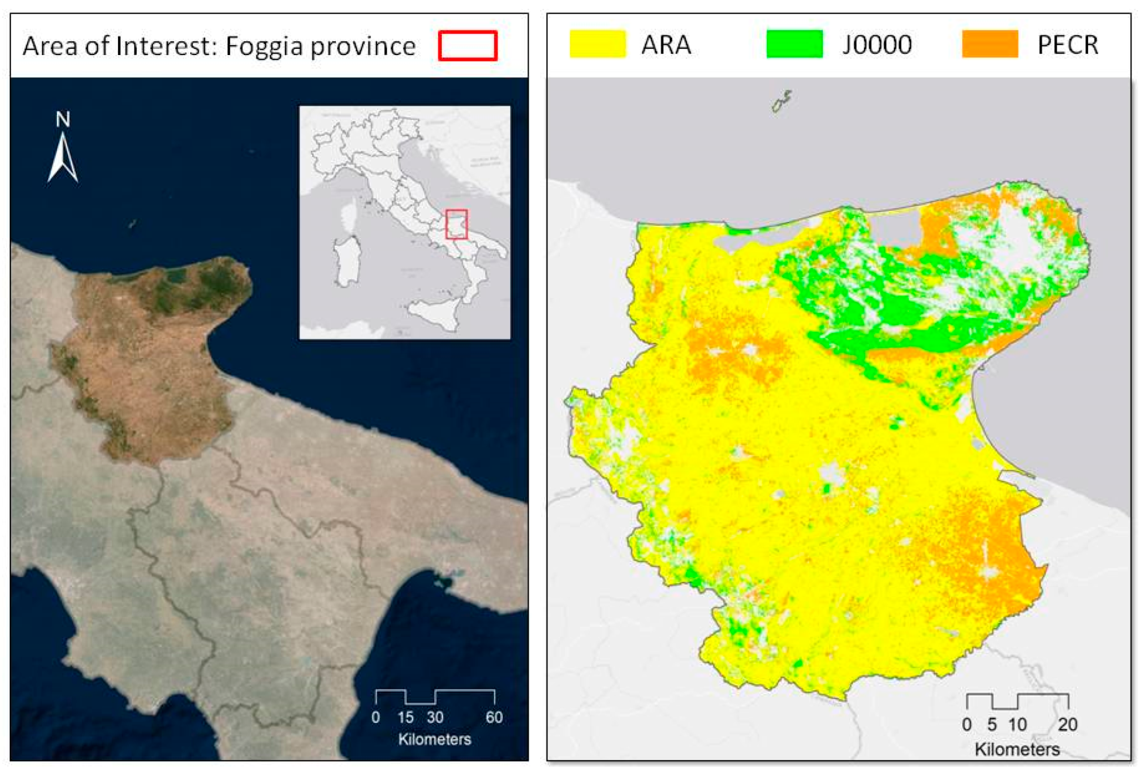
8] usually computed with statistical surveys from Eurostat. The indicators are: (1) Total utilized agricultural area (UAA) in absolute terms expressed in hectares; (2) Share of UAA expressed as a percentage of total UAA for the following four land use/cover types: arable land, permanent grassland, permanent crops, and kitchen gardens. Since the IACS/LPIS datasets available cannot allow the clear identification of areas devoted to kitchen gardens the indicator will take into account only three land uses. The exercise was carried out in the Foggia province, located in the Apulia region, Southern Italy.
2. Materials and Methods
The key geospatial source used is the LPIS from the Italian Paying Agency (AGEA) consisting of homogeneous land use/cover areas of Italian territory digitized from ortho-imagery with a very-high spatial resolution (20 cm) and with a full update every three years. In particular, LPIS provides detailed information about spatial location, identification, and quantification of agricultural, natural, and artificial land. The information about homogeneous agricultural polygons is very detailed, especially for the permanent crops. Indeed, the LPIS codes included in this agricultural land use/cover type are over 130. In addition, this dataset gives information about the eligibility for payments for those surfaces under CAP supports.
The LPIS of Foggia province, dated 2016, consists of a vector layer with over 223,000 polygons with attributes concerning: the type of land use/cover; area; municipality, and province where polygons are located.
To identify agricultural polygons to compute the indicators, we created an alphanumeric matching table for linking LPIS land use/cover codes (about 500) with crop groups from the Eurostat Annual Crop Statistics, namely: ARA (arable land), J0000 (permanent grassland) and PECR (permanent crops) [
9]. For this purpose, a semantic analysis of the LPIS and Eurostat crop nomenclatures and definitions was carried out to ensure the best correspondence between the two sources.
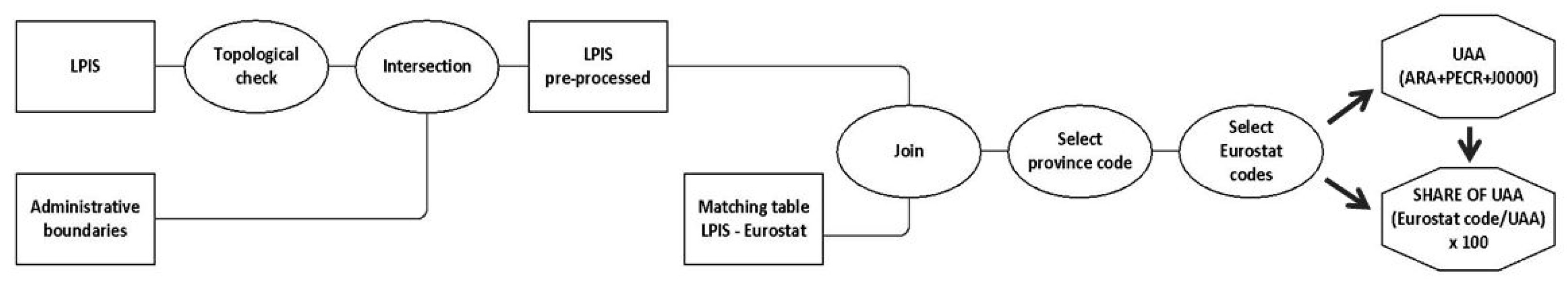
The first step of the workflow (
Figure 1) required to compute the indicators and to produce geographic vector layers is the pre-processing phase of LPIS. The operation consists of: (i) topological check and correction of vector geometries and (ii) geometric intersection with the most updated administrative boundaries (version 2020) from the Italian National Institute of Statistics (Istat). These geoprocessing tools, carried out with GIS and Python libraries, are useful to simplify LPIS data structure and to correct geometric errors that might have negative impacts on the indicators to be computed.
In the processing phase, the pre-processed LPIS was joined with the matching table. The newly created vector layer was used to select the polygons belonging to the Foggia province and with the Eurostat agricultural codes (ARA+PECR+J0000 for the indicator UAA; ARA or PECR or J0000 for the indicator share of UAA). Finally, the vector layers of the two context indicators were produced enabling the computation of the summary statistics.
3. Results and Discussion
The methodology applied allowed to produce the summary statistics for the two context indicators used for monitoring the CAP performances. Beyond the statistics produced, the relevant outcome is the production of geographic vector layers that provide a spatially explicit representation of the indicators. In addition, the indicators can be produced for several administrative units through aggregation/disaggregation procedures.
In the Foggia province, the UAA extends for 562,327 ha, 81% of the LPIS area, and about 80% of the province area.
Figure 2 shows the distribution of agricultural areas classified by three land use/cover types. While the arable lands are widespread throughout the territory, the permanent grassland is mainly concentrated in the north area (Gargano) and along the western border with Avellino province (Campania region). Permanent grassland often has a 20% or 50% of tare, consisting of broadleaf forests, Mediterranean maquis, bushes, etc.
The permanent crops cover northern and southern areas around urban zones and the northeast Adriatic coast (Gargano) and are made up mainly of olive trees (50,800 ha), vines (24,000 ha), and other unspecified tree crops (16,000 ha).
Lastly, the non-agricultural territory consists of urban and artificial areas, forests, water bodies, and wetlands.
Table 1 shows the absolute and percentage values of agricultural land use/cover types considered. Arable land represents the main macro-category with 69% of the UAA area (about 390,000 ha). At the same time, the number of arable polygons is lower than permanent crops and grassland, which means that each homogeneous polygon of arable land covers about 110 hectares on average.
Permanent crops (94,000 ha) and permanent grassland (over 80,000 ha) occupy 17% and 14% of UAA, respectively. The permanent crop polygons are the smallest agricultural polygons because their average area is less than 2 ha, while the permanent grassland polygons’ area is about 3 ha on average.
In addition, as outlined above, the LPIS dataset gives more specific information about permanent crops by providing 14 distinct classes in the Foggia province. In particular, the permanent crops identified are: citrus fruit; arboretum; vines (three different types); chestnut trees; generic tree crops (three different types); permanent crops different from tree crops; almond trees; olive trees; walnut trees; unspecified nuts trees.
4. Conclusions
The main aim of the Open IACS project is to foster the opening and reusing of tabular and geospatial data from the administrative sources (IACS/LPIS) managed by the European paying agencies in the framework of the Common Agricultural Policy. This open data service can support farmer activities and decision-making and can update and enhance European agricultural statistics derived from Farm Structure Surveys (FSS) of the national statistical offices. In addition, the IACS/LPIS data can be a valuable source for computing context indicators to support the CAP performance assessment.
On the other hand, our approach computed indicators from land use/cover maps, providing a territorial perspective of the agricultural areas that may be different from the statistical one derived from the national FSS. In particular, the UAA derived from LPIS is generally greater than agricultural areas from the statistical surveys. In fact, the LPIS contains georeferenced polygons associated with agricultural classes while the FSS collects agricultural parcels of farms with a census or sampling procedure. Considering these different approaches, the results cannot be compared. To overcome this issue, LPIS territorial data and farm data from the IACS system should be taken integrated and analyzed.
In terms of reusability, data inconsistency might limit the potential of agricultural statistics. Some obstacles can be identified in: datasets interpretation issues due to lack of metadata; management of large volume of data, especially for the vector layers; transformation required by the original IACS datasets; integration and harmonization of geospatial data from different sources and separate databases.
Lastly, LPIS data outperform the European current land use/cover data with lower spatial-temporal resolution and not detailed land use/cover classes representation (e.g., European CORINE Land Cover). For this reason, LPIS dataset may represent a huge step forward in land use/cover studies capable of making in-depth analyses from national to municipality scale, even to the agricultural parcel. Moreover, the availability of land use/cover maps with a high spatial/temporal/thematic resolution, especially for agricultural areas, guarantees a more accurate view about the complexity of landscapes useful to carry out different analyses: crop production, eco-hydrological modelling, soil consumption, surface runoff, etc.


