1. Background and Objectives
The research of remote planning evaluation systems is one of the sub-projects of the National Science and Technology Support Project “Integration and Demonstration of Intelligent Planning Construction and Integrated Management Technology for Small Town Clusters”. The system is based on the cloud service platform of the Shennongjia smart small city. The software was developed and applied in the Shennongjia forest area. Compared with other online evaluation businesses, urban planning evaluation has its own characteristics. One is that there are many kinds of evaluation projects—from the urban master plan to the detailed construction plan—and the types of planning projects are quite different. The other is that, in the process of evaluation, besides considering the merits of the project itself, other relevant factors should also be considered as thoroughly as possible. Due to the conflicts between the planning project, the environment, and the land itself, the decision-making needs to provide diversified review data support during the planning review process. It is very important to provide a wider range of space detection and spatial analysis tools. These online spatial data services and analysis tools can be more powerfully supported based on cloud platform implementation [
1].
The main purpose of the remote planning evaluation project is to realize the integration of information resources through the virtualization technology of cloud computing. It could improve the utilization of government equipment resources, fully realizing the sharing of information resources and effectively solving the integration problems between different information sources, such as the seamless integration of planning evaluation processes involving the transfer between different users, so as to enhance the information level of planning review process and improve the efficiency and the scientific nature of evaluation. At the same time, the application of remote expert evaluation subsystems, especially in remote areas and isolated areas, could make up for the lack of local funds, talents, and technology, and improve the efficiency and the management level of local planning staff.
2. Research Status and Direction
Since the emergence of Internet technology, online evaluation systems have been widely used. Online evaluation systems are generally based on B/S architecture, which has the superior performance of adapting to heterogeneous systems and can meet the requirements of users using different platforms for information sharing and data interaction through the network [
2]. Online evaluation systems are generally used in online declaration and evaluation management of scientific research projects, fund projects, dissertations, or engineering projects, such as the University thesis evaluation system developed by DreamWeaver CS3, ASP and Access database, and the online declaration and audit system of scientific and technological projects based on the B/S framework, which integrates teacher declaration, expert evaluation, and project management [
3,
4]. The evaluation system based on B/S architecture achieves high efficiency, digitalization, and networking of evaluation and management. It has the advantages of simple operation, low cost, high efficiency, convenient application, and query.
Cloud computing services are based on the increase of Internet-related services, involving dynamically scalable and virtualized resources provided through the Internet [
5]. From a professional point of view, “cloud computing” refers to a technical architecture, which mainly includes virtualization, automated deployment, distributed computing, and other technologies. It shows excellent parallel computing performance, scale scalability, and robustness [
6]. Based on the excellent performance of cloud computing technology, as a new sharing mode, cloud computing has been applied in many industries and fields, such as financial management, book management, e-government, competition evaluation, medical information construction, open teaching, and citizen interaction platforms. This is precisely because cloud computing can provide users with reliable, customized, and maximized resource utilization services. In many of its applications, it also provides a feasible and effective way for remote planning project evaluation businesses. It can help the remote expert evaluation system to build a more effective service system than the general B/S architecture, which can dynamically and flexibly meet the remote management and the evaluation needs in remote mountainous areas while reducing costs.
At present, there is little research and system design on remote urban planning evaluation systems in the literature. Therefore, the remote evaluation system in this study is not only an exploration of urban planning project evaluation methods but also an exploration of the design and the implementation of a remote evaluation system for an online planning project. In this study, with the help of existing cloud platform building technology and methods, besides considering the virtual technology of cloud computing itself, the main difficulty lies in introducing WEBGIS technology and software as a service (SaaS) service mode to support spatial data operation into cloud platform building [
7,
8]. More importantly, due to the characteristics of planning projects and the diversified requirements for planning review tools, the focus of this paper is how to use the existing technical methods to better support the efficient completion and the seamless connection of planning review processes.
3. The Technology and Methods
The remote expert evaluation system investigates the existing cloud computing and application methods and the establishment methods of government cloud platforms related to the system establishment, setting the goal of system establishment through the deepening of user needs in the process of software development, repeated tests, and improvement of system functions. By using virtualization and distribution technology, SaaS mode and application technology, WEBGIS Internet spatial data management technology, WEB database technology, and other methods, the subsystem functions are designed according to different users. Finally, the seamless connection of data submission, data audit, expert allocation, expert evaluation, and evaluation submission is realized.
1. Virtualization and distributed technology
Virtualization and distributed systems are one of the key technologies used to implement cloud computing. They solve a problem together, which is to reconfigure physical resources into logical resources, realize dynamic allocation, flexible scheduling, and cross-domain sharing of information technology (IT) resources, improve the utilization of IT resources, and make IT resources truly become social infrastructure. They provide productive technical support for the establishment of remote evaluation systems and ensure the efficient operation of remote evaluation systems [
9]. In the construction of remote expert evaluation systems, in order to serve the front-end users, the back-end cloud service platform uses virtualization, distributed storage, and other technologies to establish an independent system development and operation environment on the virtual machine and share and dynamically allocate backstage computing and storage space with other subsystems. In this virtual environment, by installing Windows Server 2008 operating system, IIS7.0 or above WEB intermediate server and MySQL database system, the remote expert evaluation system builds an independent development environment, completes the system function development, and achieves full utilization and a high efficiency configuration of the system internal resources.
2. SaaS mode and application technology method
SaaS stands for software as a service, which is a completely innovative software application mode that is rising in the 21st century. For users, using SaaS services will be simpler and more convenient, but for service providers, SaaS system development is more difficult [
10], especially when it comes to deep application of collaboration, because the problems will be more complex.
In the process of establishing a remote evaluation system, multi-level and multi-category urban planning faces uncertain spatial analysis requirements. For the users, it is difficult to obtain, operate, and maintain the massive spatial data involved in the planning. Therefore, the system makes use of the existing spatial cloud service platforms such as Dituhui and GeoHey to provide basic spatial data and spatial analysis services with geographic coordinate positioning service, DEM service, road accessibility service, and public facility information service for planning projects so as to meet the needs of project management and public analysis in a larger space.
3. WEBGIS Internet spatial data management technology
WEBGIS is a technology that uses WEB technology to expand and improve geographic information systems. It is a web-based client/server system that publishes and applies geospatial data through the Internet to realize the sharing and the interoperability of spatial data, including Internet spatial query and retrieval, spatial model services, organization of WEB resources, etc.
Part of the assistant analysis module of the remote expert evaluation system can be realized by using WEBGIS technology, such as the detection module of planning land avoidance, which has clear spatial operation requirements. It uses basic farmland and ecological protection planning data to determine the scope of prohibited construction land and uses planning data such as volume ratio and building density to determine the restricted construction land. The data of this type of module are mainly internal data of the system and can be developed independently by WEBGIS technology.
4. WEB database technology
WEB database refers to the database resources accessed by WEB query interface in the Internet. Users access the database interactively by the WEB server through the browser-side operation interface. The information submitted by users to the database and the information returned by the database to users are displayed as a web page. WEB database can integrate database technology with WEB technology, make the database system an important part of the WEB, and realize the seamless combination of database and network technology.
The main function development of the remote expert system is based on the support of WEB database technology. It uses MySQL database, a widely used WEB database system nowadays, to support user data management, index and evaluation expert assignment management, review status management, expert information query, and project association query in the process of evaluation so as to realize the efficient operation and the convenient use of remote expert evaluation systems.
4. System Architecture Analysis
4.1. User Composition of System Platform
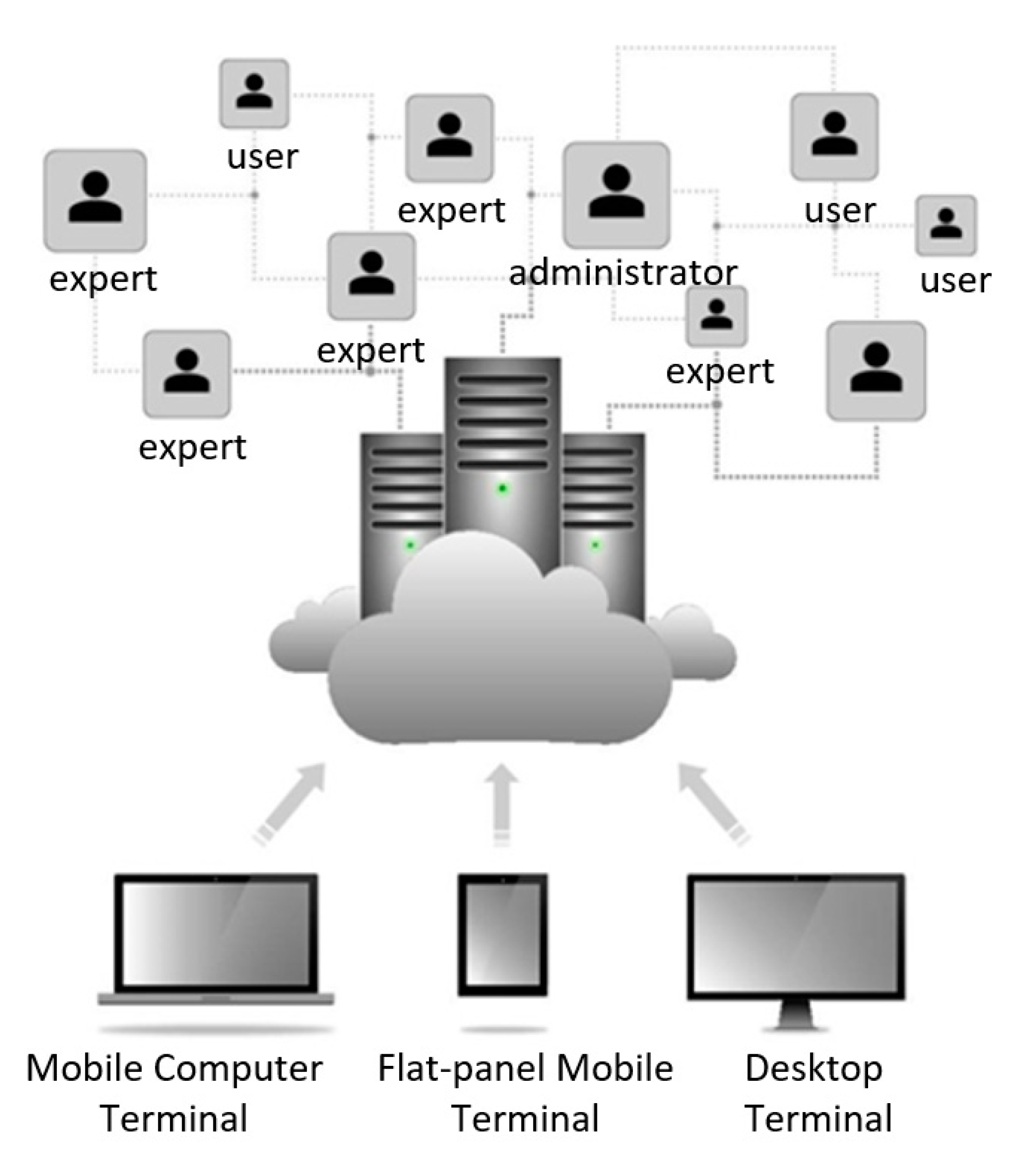
Relying on the “Shennongjia Town Cluster Planning and Integrated Management Service Cloud Platform”, the remote expert evaluation subsystem is built for multi-user service mode. The business software and the data are managed by the cloud platform. The main users are planning managers, including expert users and data submitting users. Users can access services through the cloud anytime and anywhere through mobile computers and mobile phones, as shown in
Figure 1 [
11].
4.2. System Main Structure Relationship
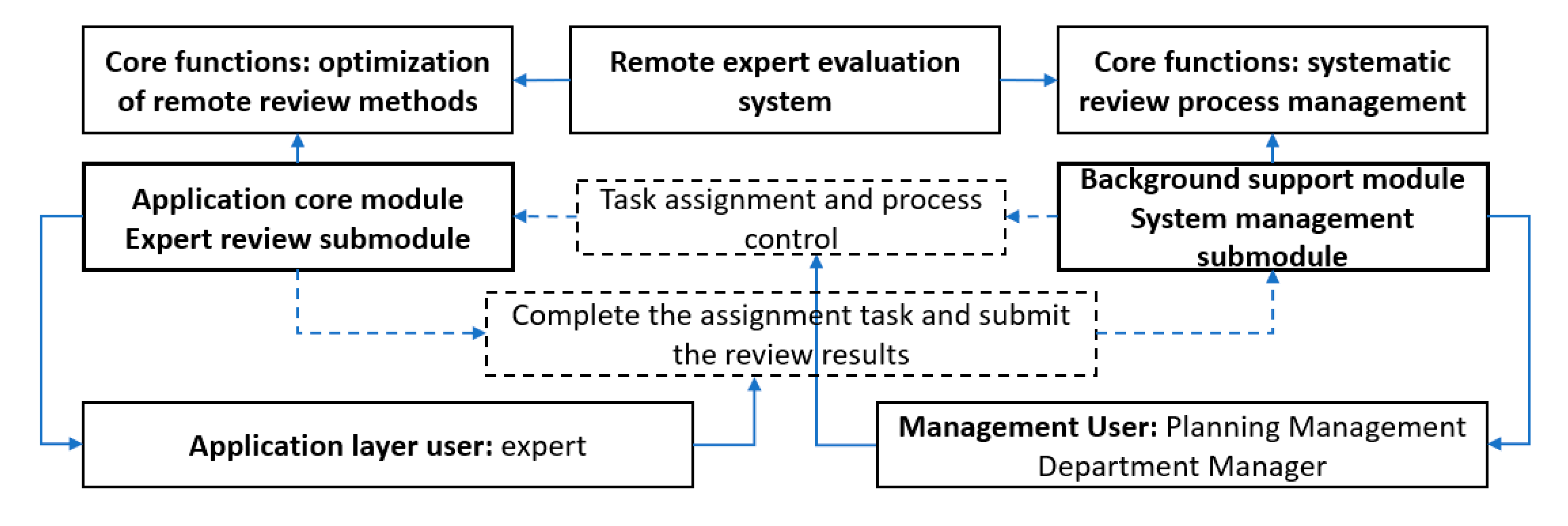
The main users of the system are experts and planning management departments. These two users assume the core functions of the system and constitute two important sub-modules in the system, as shown in
Figure 2. Expert sub-module and administrator sub-module are independent and interrelated. Among them, the main function of the expert sub-module is to complete the evaluation and submit the evaluation results to the administrator with the help of data and tools of cloud platform services. The administrator sub-module is responsible for the construction of the expert database, the assignment of evaluation experts, the control of the review process, and other expert information management and review process management.
4.3. System Data
The expert evaluation system based on the cloud platform is more convenient to manage and use data. There are many data in the expert evaluation system, including the main data of the evaluation, the auxiliary data for supporting the evaluation, and the data generated continuously in the operation of the system. The various data play different roles in the system, and the use rights of the data are also different, as shown in
Table 1.
5. The Overall Design of System
The overall design of the system mainly includes system module design and system cloud service technology platform architecture design. Through the overall design, it provides support for system sub-module design and interface design development [
12].
5.1. System Structure
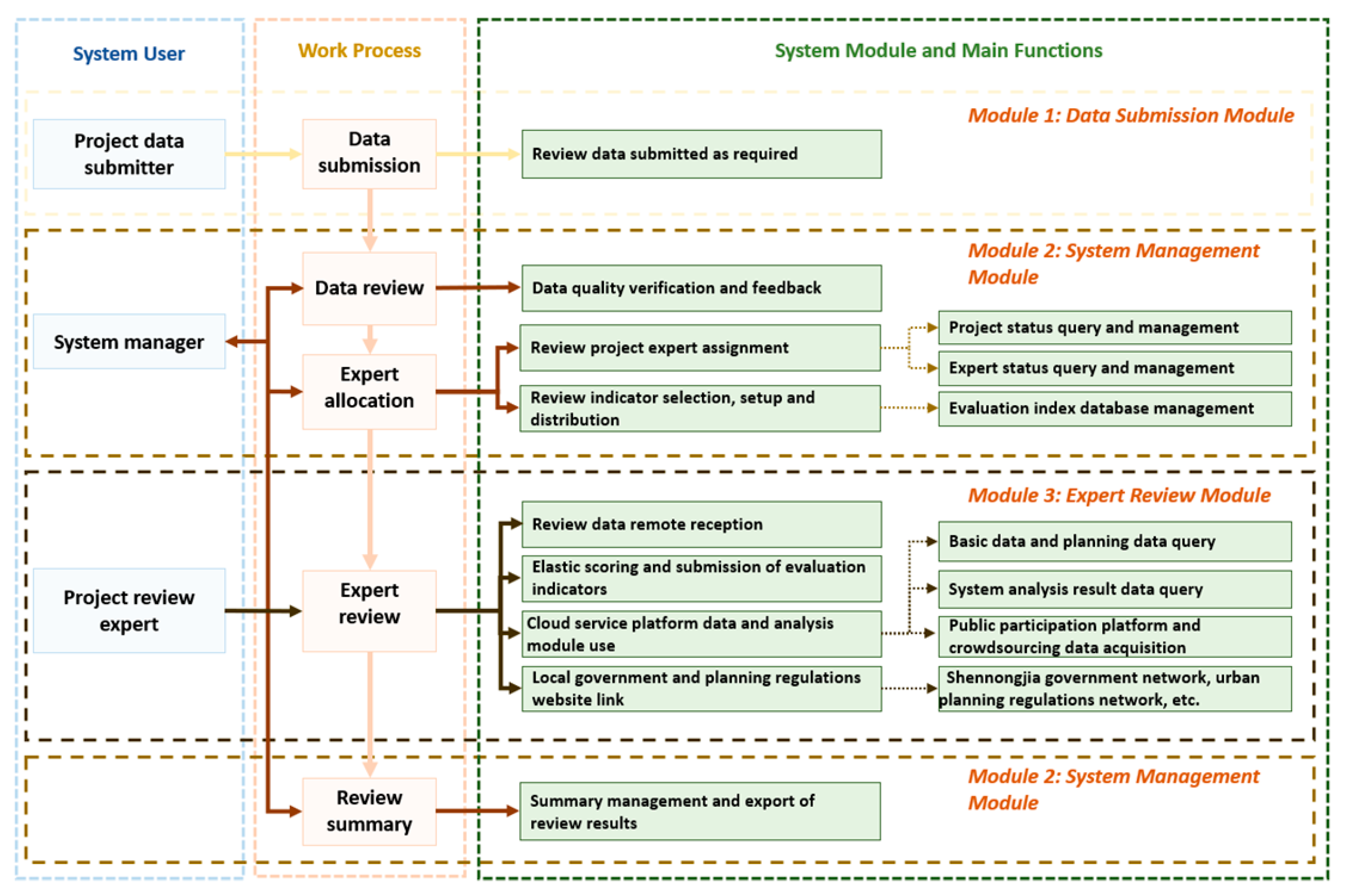
The system builds three sub-modules based on the three types of users according to the review process. The system administrator works throughout the review process, and the expert review process is the core function of the system. It can improve the scientific nature and the efficiency of the review through powerful technical means. Therefore, its function and effectiveness determine the performance of the system. This reflects the main role of administrators and experts. The main structure is shown in
Figure 3.
5.2. Basic Architecture of System Cloud Service Platform
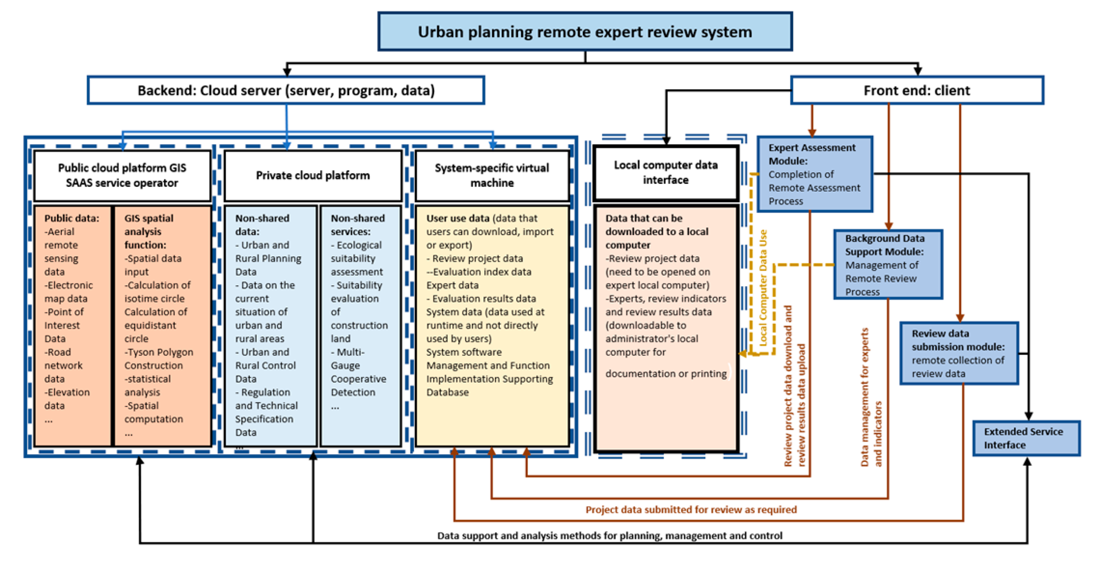
The remote expert evaluation system is constructed with cloud technology and SaaS mode. It provides users with all the network infrastructure, software, and hardware operation platforms needed for informationization and is responsible for all the previous implementation and post-maintenance services. Therefore, users do not need to know where the server is or how it works inside and can use various resources transparently through high-speed Internet. In this paper, the remote expert evaluation system based on the cloud platform is mainly composed of two parts: the front end and the back end, as shown in
Figure 4.
The front end is the client. All users, including planning project reviewers, project submitters, and review experts who make the planning plan, enter the system through the client and communicate and interact with the system and other users through it. The front end does not require complex software management and maintenance, and the thin client consisting of the client and the browser used to access the cloud can meet the basic usage requirements.
The back-end is the cloud itself. It provides applications, computers, servers, and data storage for expert review of cloud services. The remote expert evaluation system software and the transaction data are mainly placed on the back-end cloud service platform. The service platform is divided into two categories—one is a private cloud service platform built for the government’s internal data center, providing more secure data and review process management services, and the other is an external public cloud service platform that provides cloud service platforms, including the SaaS mode. The SaaS model is conducive to finer development in the vertical field and can provide expert evaluation systems with more complex spatial computing and analysis services that require a large amount of spatial information support. This kind of service capability of computing, storage, software, and hardware provided by non-local cloud servers can enable government data centers to put resources into needed applications, reduce costs, improve the utilization of software and hardware resources, and obtain supercomputing capabilities if necessary [
13].
6. System Function Design
The system sets three modules according to different users, and different modules have different functions. The data submission module is the basis for the operation of the entire system, and the user can be mainly responsible for planning data submission and positioning of the planning location. The administrator module is an important module for the administrator to manage the system and calculate and output the results, which plays an important supporting role in the operation of the system. The expert evaluation module is the core module of the system. Its main function is to evaluate means and optimize technology.
6.1. Main Functions of Data Submission Module
The core function of the data submission module is to submit the evaluation data as required, which mainly includes the following functions:
The system provides real-time upload of planning results data and ensures the uniformity of data in project evaluation.
In order to ensure that the coordinate system of the review project is consistent with the basic data coordinate system, the unified positioning of the coordinate system is determined for the planned project.
6.2. Main Functions of Expert Evaluation Module
The core functions of the expert evaluation module are review tools and technology optimization, which are mainly realized through the following functions:
Through the network remote delivery of data, the delivery and the evaluation of project data are not constrained by time and place.
Dynamic and flexible use of evaluation indicators.
The spatial data of the planning project within the scope of Shennongjia are visualized, and the status or the planning data within a certain range can be viewed.
The data analysis is real-time by calling services such as land avoidance detection, spatial multi-mode analysis, and other related services.
Enter the database of urban planning regulations and technical specifications to provide support for urban planning regulations and technical specifications.
6.3. Main Function of Manager Module
The core function of the administrator module is the systematic management of the database, which mainly includes the following functions:
Expert database management refers to the management of expert data entry, editing, data import and export, and the management of expert evaluation projects. It can query the project that experts have evaluated and the project that experts are reviewing, etc.
Define the status of each review project, including the unassigned experts to be evaluated, experts that are being reviewed, experts that have been reviewed, and the number of projects in different review phases.
Open management of evaluation indicators, including increasing the type of evaluation and increasing or decreasing the evaluation factor, and designating evaluation indicators for the planning project.
Summarize and derive the evaluation results.
Audit the integrity and quality of submitted data.
7. System Application Practice and Performance Evaluation
This project completed the development of remote expert evaluation system software based on cloud technology and realized the systematic management of planning project evaluation. The results show that the core cloud computing technologies such as server virtualization and parallel computing provide good technical support for the establishment of remote evaluation systems and ensure efficient operation. The experimental results of the system simulation are as follows:
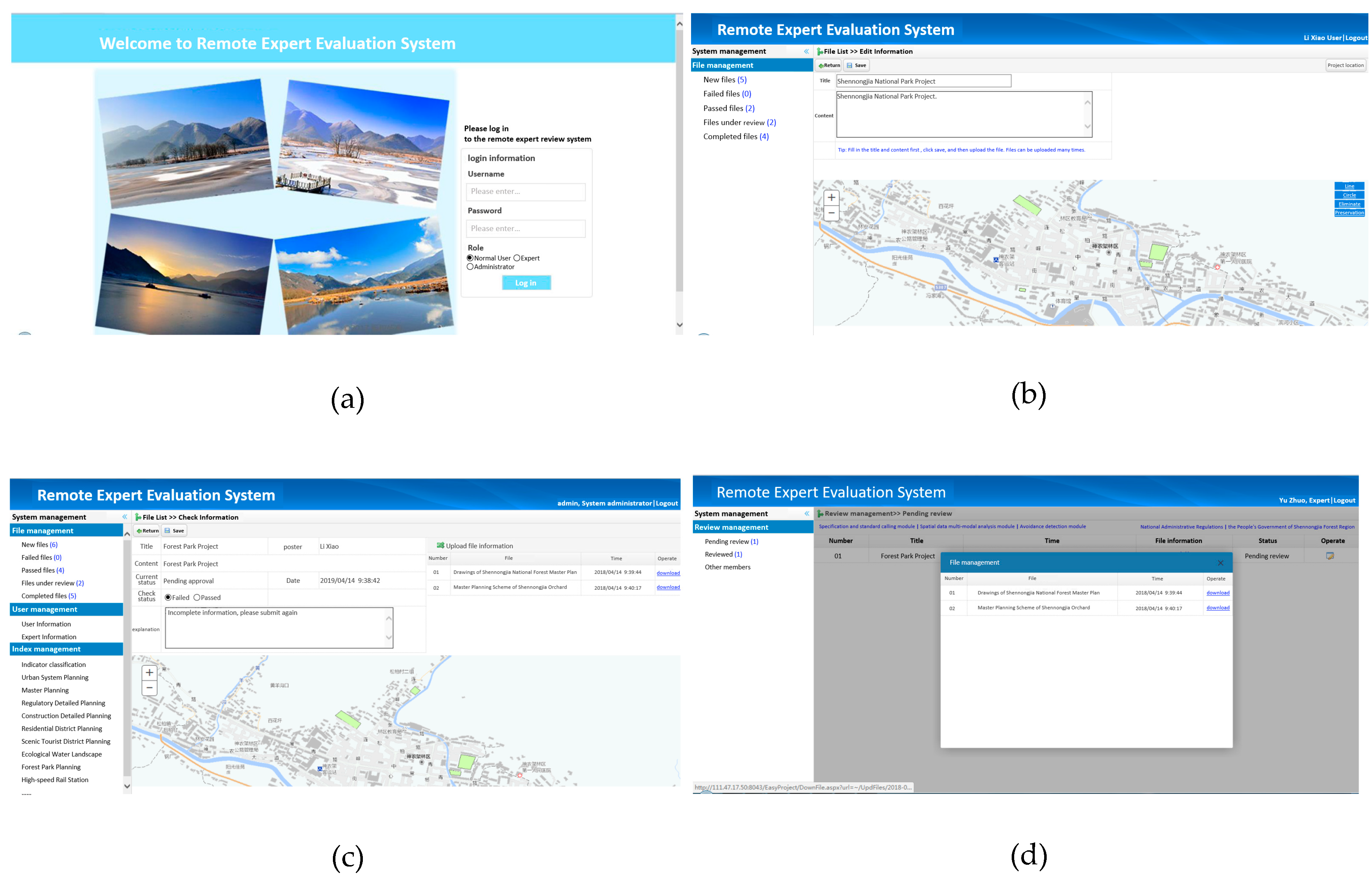
The system supports login with three identities: declaring user, administrator, and user. The user chooses the appropriate role to login to the remote expert review system. The login interface is shown in
Figure 5.
Users submit relevant planning texts and drawings through the project data submission module, as shown in
Figure 5. Files and documents that have not passed can be re-uploaded after being modified according to the administrator’s response.
The administrator receives and reviews the submitted project documents through the system administrator module, as shown in
Figure 5, and assigns the project experts, manages the expert database, and manages the review process.
Experts through the expert review module, according to the assigned expert review project, link related data and tool service platform to assist the efficient implementation of project review work, as shown in
Figure 5.
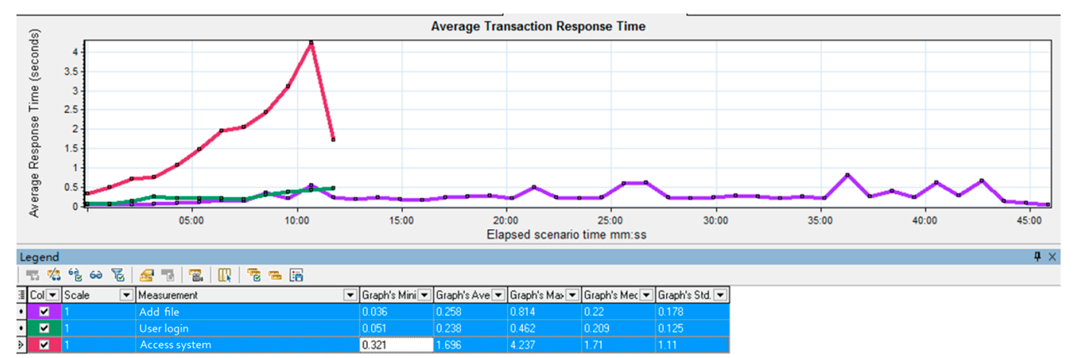
By running a 50-user online scenario, 8266 operations were performed during the period to confirm performance metrics such as response time of each function. Average transaction response time tests show that access system response time is less than 2 s, and user login response time and new file response time are less than 1 s, as shown in
Figure 6. The results show that the transaction success rate is 100%, which meets the requirements of technical indicators, and the test range of software technical indicators is as shown in
Table 2 below.
The system can also be used by users who do not have professional operation skills and equipment. Through the practical application in remote mountain areas of Shennongjia, good results have been achieved in planning and evaluation. For the planning management department, it manages the planning review process and review data through the unified service platform, which facilitates the planning and the management of remote mountainous areas, greatly improves work efficiency, and lays a technical foundation for planning and review work. For experts, it solves the problem that the planning review is not timely due to the inconvenience of traffic. It is helpful to complete the evaluation work efficiently by building various cloud service links to carry out various spatial analyses.
8. System Benefits and Future Development Consideration
The demonstration application of the project in Shennongjia Forest District Government and its subordinate towns meets the needs of various users in the evaluation of urban planning projects, mainly including the following aspects, beginning with faster and more intelligent evaluation. The system provides real-time planning and evaluation project data transmission, comprehensive evaluation project status display, convenient evaluation expert allocation and evaluation results management functions, and greatly improves the timeliness. At the same time, the system also provides expert users with planning and technical specification library query and spatial analysis function support to provide more intelligent services for expert users. Second, it explores new ways for expert review work and improves the level of local government affairs informatization and office automation. Through the establishment of a remote expert review system, another way to start planning and reviewing, especially for remote mountainous areas, is more obvious in terms of social and economic benefits. At the same time, it is also the use of new office tools and the upgrading of management concepts under the rapid development of Internet technology. Third, the establishment of a unified system management platform is conducive to the sharing of technical data resources and the systematic management of the review process. The construction mode opens the attempt of SaaS construction mode. Based on MySQL and other open source software construction, it meets the requirements of security and controllability and has the characteristics of flexible architecture and easy expansion, which can meet the needs of future business development.
Of course, a planning evaluation system is a system involving a wide range of fields. It involves not only the content of administrative office automation but also the expression of urban planning analysis methods based on discipline and professional requirements. The system still has great development space and faces greater difficulties. The main content needs to be improved to include the following two points—firstly, the requirement of real-time communication functions such as remote evaluation video needs to be independent of the public social platform (such as QQ) and be established in conjunction with the evaluation project, and one project corresponds to one communication space to meet the real-time communication requirements of the evaluation work. Secondly, the diversity and the uncertainty of planning types affect the design of planning indicators measurement function and spatial analysis function. It is difficult to fully realize these contents, and more research is needed in the later stage.
The planning evaluation system covers a broad scope of field. This research focuses on the remote areas such as Shennongjia, which are backward in information construction. With the help of powerful cloud computing capability, the remote evaluation system was developed to provide more basic information support and powerful spatial analysis methods for remote expert review work. To a certain extent, it drives the information construction in remote areas and makes up for the lack of information technology, hardware facilities, and talents in remote mountainous areas, which has greatly helped urban and rural construction and local development of Shennongjia.


