Article

Sustainable Design for Geotourism Interpretation Centres: Enhancing the Santa Elena Peninsula Geopark Project Experience

by
Gilda Rubira-Gómez
1,
Jenifer Malavé-Hernández
2,*,
María Jaya-Montalvo
2,3,
Jimmy Candell-Soto
4,
Jhon Caicedo-Potosí
2,
Bethy Merchán-Sanmartín
2,3,
Maribel Aguilar-Aguilar
2,3 and
Fernando Morante-Carballo
2,5,6
1
Facultad de Ciencias de la Ingeniería, Universidad Estatal Península de Santa Elena (UPSE), Avda. Principal La Libertad-Santa Elena, La Libertad 240204, Ecuador
2
Centro de Investigación y Proyectos Aplicados a las Ciencias de la Tierra (CIPAT), ESPOL Polytechnic University, Campus Gustavo Galindo Km 30.5 Via Perimetral, Guayaquil P.O. Box 09-01-5863, Ecuador
3
Facultad de Ingeniería en Ciencias de la Tierra (FICT), ESPOL Polytechnic University, Campus Gustavo Galindo Km 30.5 Via Perimetral, Guayaquil P.O. Box 09-01-5863, Ecuador
4
Facultad de Ciencias Agrarias, Universidad Estatal Península de Santa Elena (UPSE), Avda. Principal La Libertad-Santa Elena, La Libertad 240204, Ecuador
5
Facultad de Ciencias Naturales y Matemáticas (FCNM), ESPOL Polytechnic University, Campus Gustavo Galindo Km 30.5 Vía Perimetral, Guayaquil P.O. Box 09-01-5863, Ecuador
6
Geo-Recursos y Aplicaciones GIGA, ESPOL Polytechnic University, Campus Gustavo Galindo Km 30.5 Vía Perimetral, Guayaquil P.O. Box 09-01-5863, Ecuador
*
Author to whom correspondence should be addressed.
Heritage 2024, 7(1), 499-516; https://doi.org/10.3390/heritage7010024
Submission received: 30 September 2023 / Revised: 6 December 2023 / Accepted: 13 December 2023 / Published: 20 January 2024
(This article belongs to the Special Issue Museums for Heritage Preservation and Communication)

Abstract

:
Geosites represent important elements of geoheritage for promoting geotourism sustainable practices aimed at education and conservation. The Santa Elena Peninsula Geopark Project has several locations with geological, cultural and historical richness and the potential for geosites and tourist development. However, these places lack infrastructures that improves tourist reception and local geoeducation. In this study, Geotourism Interpretation Centres (GICs) were designed using sustainable and architectural criteria to improve geoeducation and geotourism in geosites of the Santa Elena Peninsula Geopark Project. The work included two stages: (i) selection of the geosites and (ii) design of the GICs. Four geosites were selected for the design: Barrio Ingles Ancon Parish, Manglaralto’s Coastal Aquifer, San Vicente Hot Springs, and San Rafael Mines. A GIC design adaptable to the four sites is proposed based on three zones: recreational–passive, services and cultural. The design prioritises sustainability, considering four criteria: political–economic, social, cultural and environmental. The proposal takes advantage of the area’s natural materials and the natural climatic conditions to offer a space that improves the geotourism experience in mimicry with the environment, promoting cultural roots and community benefit.

1. Introduction

Geoheritage comprises the set of natural geological resources [1], in situ or ex situ, of territory with outstanding scientific values, which, by having added aesthetic, cultural and educational values, can be important for society [2]. Geoheritage is also a driver of conservation and sustainable use [3]. Within geoheritage, geosites are some of the greatest exponents [4], constituting places with recognised scientific, cultural and aesthetic content, which makes them viable for science, education and tourism [5]. Geosites can contain diverse wealth linked to their geological, geomorphological [6], hydrogeological [7], structural [8], mineralogical [9] or archaeological [10] content and are key to the proposal of routes or itineraries that promote the development of geotourism.
Geotourism is a type of sustainable tourism based on the responsible tourist use of geology, which enables teaching about local geological manifestations, promoting the protection of these natural areas [11,12]. Geotourism also contributes to the economic development of communities, which benefit from the increase in local businesses and the creation of sources of employment [13].
Regarding conservation, education and sustainable economic development, geoparks are among the most important strategies [14]. Geoparks are well-defined areas encompassing geographic or geological heritage sites selected for their rarity, history, scientific importance, occurrence of processes and natural quality [15]. Geoparks realise the sustainable use of the territory through geotourism, education and other activities that take advantage of local natural and cultural resources [16]. At a global level, the increase in the number of geoparks has allowed greater awareness of geological heritage and its scientific and cultural benefits to the community in general [17].
Since 2015, geoparks have been officially recognised by the United Nations Educational, Scientific and Cultural Organization (UNESCO) through the UNESCO Global Geopark (UGGp) designation [18]. There are a total of 195 recognised geoparks in 48 countries worldwide at the moment [19]. In Latin America and the Caribbean, there are a total of twelve geoparks recognised by UNESCO, in the countries of Brazil, Mexico, Uruguay, Peru, Chile, Nicaragua and Ecuador [20].
Geopark attractions can be divided into two categories: (i) the main (geosite) and (ii) support (physical infrastructure and facilities) [21]. Various methods exist to interpret geological heritage, ranging from guided tours and walks to information and visitor centres [22]. Specifically, the presence of information panels, public information infrastructure, exhibition rooms or museums, and a website are included in the checklist to assess aspiring UGGps [23]. According to Began [24], information and visitor centres must be designed and built to integrate harmoniously with the natural environment. Indeed, these centres need to adapt to the unique characteristics of each geosite to enrich the geoeducational and geotourism experiences of visitors.
The literature emphasizes the multifaceted nature of interpretation centres in tourism, highlighting their potential to offer a combination of museum content, themed attractions and tourist information services [25]. The flexibility of interpretation centres is highlighted, ranging from open-air shelters with basic exhibits [26,27] to sophisticated air-conditioned museums [28]. The design of an interpretation centre must be a balanced combination of aesthetics, functionality and effectiveness in transmitting information and should promote a holistic approach to integrating different cultural, biological [29] and geological values [30,31].
The limited existence of education/interpretation infrastructure and museums are among the five main difficulties identified by geoparks when managing and organizing educational programs [32]. However, there are worldwide examples of geotourism, where interpretation centres play an important role in geoconservation and education. In Belgium, Bernissart’s case study illustrates the integration of paleontological discoveries into the tourism industry. The village, where 29 Iguanodon skeletons were unearthed in 1878, established the “Le musée de l’Iguanodon” interpretation centre in 2002 [33]. This centre seeks to recreate the sense of place and contextual events surrounding the remarkable discovery of the dinosaurs. Despite the inaccessibility of the original discovery outcrop, the interpretation centre attracts approximately 7000 visitors annually. The success of Bernissart’s interpretation centre underscores the economic and cultural benefits of connecting natural heritage with tourism, emphasising the importance of geoconservation in the development of local geotourism offers.
In the context of UGGps, some examples of interpretation centres are “Natur and Geopark Mëllerdall” (Luxembourg) and “Basque Coast Geopark” (Spain), which share common characteristics like having spaces dedicated to thematic exhibitions, including information panels, 3D models and multimedia, where visitors can actively participate through touch screens, simulations and ex situ specimens related to the geology and cultural history of the region. Natur and Geopark Mëllerdall’s design emphasizes a comprehensive 3D exhibition illustrating the evolution of the geological subsoil from its origins as a seabed to the transformation of the landscape upon solidification [34]. The centre further explores human interaction with natural resources from the Stone Age to the modern era. This centre links the development of cultural landscapes with diverse ecological niches. Similarly, the Algorri Interpretation Center (Spain) [35] in Zumaia centres its design on interpreting the geological significance of the K/T boundary and Flysch formation, offering visitors an engaging and informative experience (e.g., walking and boat tour services) [36,37]. Both centres employ an integral approach, merging geological processes, human history and ecological development to provide a multidimensional understanding of their geopark regions’ interconnected natural and cultural elements.
Ecuador officially recognised its first geopark in 2019, called Imbabura UGGp [38]. Starting this year, the number of geopark initiatives has increased, with two aspiring geoparks (Tungurahua Volcano [39] and Napo-Sumaco [40]) and several geopark projects (Santa Elena Peninsula, Ruta del Oro, Puyango Petrified Forest, Quito, Jama-Pedernales and Galapagos [41]).
The Santa Elena Peninsula Geopark Project’s area enjoys a unique aesthetic, geological, archaeological, historical, cultural and tourist richness [42], making it an exceptional place for geotourism. However, due to a lack of government investment and its rural location, most of the sites that make up the geopark have a limited plan to promote tourist attractions, and the physical facilities need improvements to stimulate understanding of the geological heritage of the area. The tourist infrastructure in the geoparks not only enriches the visit of tourists but also helps in the purpose of geoeducation by creating spaces for the dissemination of relevant scientific information regarding the geosites, generating a growing interest in the public and contributing to a deeper appreciation of the local geology, history and culture, which can guide the recommendation of these places and the attraction of a greater number of tourists [43,44].
In this sense, the planning of tourism infrastructure in the Santa Elena Peninsula Geopark Project is essential to improve the geotourism and geoeducational experience and, at the same time, minimize the impact on the geoheritage. Design recommendations are a key step in the implementation of architectural infrastructure. In conservation sites, new trends promote concepts of sustainability and aesthetic harmony through the use of ecological and local materials [45].
In this way, sustainable infrastructures are a preferable option to conventional infrastructures (e.g., reinforced concrete), offering numerous advantages, such as a lower environmental impact in their construction and use phase, when considering the use of highly durable materials and resistance, often natural and local, and designing for energy savings. In this context, the study addresses the research gap related to a design proposal that not only meets the sustainability criteria promulgated by UNESCO but also provides triaxial connections between the geosites (geoheritage value), interpretation centres (geoeducational value) and additional values (the cultural and ecological heritage) of the environment to satisfy the interests of the different geotourist profiles. This work aims to design Geotourism Interpretation Centres (GICs) considering sustainability criteria using (Computer-Aided Design) CAD tools and the selection of sustainable resources for sustainable infrastructures in geosites of the Santa Elena Peninsula Geopark which promote the development of the geoeducation and geotourism.

2. Study Area

The study focuses on the province of Santa Elena (Ecuador), located on the Eastern Pacific coast, specifically in the area of the Santa Elena Peninsula Geopark Project, which mainly comprises the northern, southern and southwestern territory of the province (Figure 1a,b). The province consists of three cantons (Santa Elena, La Libertad and Salinas), with its main city being Santa Elena (Figure 1a,b). The main activities of the province include commerce, agriculture, livestock, forestry and fishing [46]. Furthermore, tourism is promoted as an alternative to economic development [47], using coastal landscape resources and areas with biological, geomorphological, cultural, archaeological and paleontological interests [48,49,50,51].
At a socioeconomic level, Santa Elena is one of the provinces with the highest poverty rates in Ecuador due to the high degree of inequality and the lack of employment opportunities, which affect the province’s development. Poverty due to unmet basic needs in the Santa Elena province is 72.2%. At the cantonal level, it is 80.8% in Santa Elena Canton, 67.0% in La Libertad Canton and 61.0% in Salinas Canton [46]. Regarding the educational level of the population, it generally reaches the levels of primary and secondary education.
The Santa Elena Peninsula Geopark Project has been developed to offer the province of Santa Elena an opportunity for community improvement through sustainable tourism, promoting the enhancement of geoheritage and creation of sources of employment, along with the protection and preservation of the territory [42,48,49,52]. At the moment, the geopark initiative has an extensive inventory that includes 51 geosites (Figure 1b) of diverse interest: geological, geomorphological, stratigraphic and hydrogeological (e.g., caves, beaches, cliffs, hot springs, and aquifers), industrial and geo-industrial interest (e.g., oil wells and mines), paleontological interest (e.g., museums), and cultural–archaeological sites (e.g., Barrio Ingles Ancon Parish) [49,53,54]. It is important to mention that some sites of geological interest to the project are located in the Ancon parish, which has been declared a Cultural Heritage of Ecuador because of its historical legacy of oil activity [55,56].

3. Materials and Methods

Our methodological approach considers geoheritage sites to which value is added through a sustainable tourism infrastructure that provides facilities for tourism development in compliance with four sustainability criteria: political–economic (economically accessible), social (benefiting the community), cultural (integrated with local cultural values and their promotion) and environmental (with materials from the area and taking advantage of the local climate). For this, the structure of the study was developed in three phases (Figure 2): (i) the selection of geosites, (ii) acquiring the geoeducation and community perspective and (iii) the sustainable design of the Geotourism Interpretation Centres.

3.1. Phase I: Geosite Selection

In this phase, a group of geosites from the Santa Elena Peninsula Geopark Project was selected to design sustainable architectural adaptations. The geosites were selected through expert evaluation by applying the Delphi Method [49,57], applying a questionnaire as the main tool to allows the knowledge of the perspectives of experts within the geological (scientific, academic, tourist value), social (impact of the geosites at the level of community geological knowledge), economic (potential economic development of the province) and academic (possibility of learning environments that integrate community, academia, business, and government entities) fields. The experts were recognised as researchers of geotourism, environment, civil engineering and architecture, including the opinion of the authors of the work. In general, the group of experts who participated in this phase included four professionals and eight article authors, in which gender equality was highlighted (six women and six men) with an age range of 28–60 years. Three Universidad Estatal Península de Santa Elena (UPSE) teachers and researchers from the Santa Elena Peninsula Geopark project were included with experience in three main areas: (i) mining–industrial heritage, (ii) ecological infrastructure design and (iii) sustainable tourism development. Five ESPOL Polytechnic University researchers–teachers with experience in (i) civil engineering and environment, (ii) water management and nature-based solutions and (iii) geodiversity and geoheritage comprised the rest of the team. Finally, the team had the support of the scientific committee director and the management committee director of the Santa Elena Peninsula Geopark and Ruta del Oro Geopark Projects, who contributed with their knowledge of geological heritage and sustainable community development.
The selection criteria were based on four main aspects: (i) the local geological environment, (ii) geosites’ representativeness, (iii) geographical location, and (iv) the protection priority (geoconservation) of the geosites based on previous evaluation studies [42,48,49,52]. Finally, within this work phase, field visits to the selected geosites were included to define the potential location of the geotourism interpretation centres, avoiding alterations to the geological richness of the sites or the surrounding ecosystem and environment.

3.2. Phase II: Geoeducation and Community Perspective

This phase included a process of socialising the geological wealth of the Santa Elena province and the importance of the Santa Elena Peninsula Geopark project in local, sustainable development. The authors of this work and a focus group of community representatives and municipal authorities from the four sites selected in Phase I participated in the process.
The community intervention was recorded through a semi-structured questionnaire (Questionnaire S1) divided into four sections: (i) general information about the participant, (ii) limitations within the tourism sector (financing, promotion and basic services), (iii) estimated tourism statistics for each site (affluence, frequency of visits, tourist profile, preferential tourist season, the objective of visits and average stay) and (iv) interest in the construction of geotourism interpretation centres (e.g., types of identified geological interest, conditioning needs, geoconservation and geoeducation). The data allowed us to obtain a detailed view of the tourism situation in each sector and establish considerations for the approach to the design of the interpretation centres (dimension, materials, geo-education strategies and community participation). The questionnaire was carried out virtually through the Zoom platform with a moderator for the rounds of questions for each stage.

3.3. Phase III: Sustainable Design of Geotourism Interpretation Centres

In this phase, the design of the Geotourism Interpretation Centres was developed by considering the general needs of the four geosites selected in the previous phase. The design considered sustainable constructions that respond to the political–economic, social, cultural and environmental axes. From a political–economic and cultural point of view, the design considers the use of construction materials typical of the area with design and finish according to the culture of the place, adhering to the construction regulations of Ecuador, in particular, the NEC-SE-Housing [58] and NEC-SE-Guadua chapters of the Ecuadorian Construction Normative [59] (NEC, by its acronym in Spanish), which specify the guides and standards for the design and construction of buildings in the country for safety, durability, seismic resistance, accessibility and energy efficiency [60]. Additionally, proposals for sustainable energy sources are proposed that, combined with construction materials from the area, will reduce construction and maintenance costs.
Within the social axis, the proposed design combines technical criteria with the needs and proposals of the inhabitants, highlighting the community’s cultural identity and the geological richness of the area to create continuous learning environments in which geotourism is promoted as a tool to achieve sustainable community development. The selection of construction materials considered the proposals of the inhabitants, giving special attention to the materials commonly used by artisans and builders in the area, with the aim of guaranteeing their participation when the project is implemented and generating employment opportunities in the community. On the other hand, the proposed design addresses the environmental axis, with proposals coupled to the surrounding environment, minimising the environmental impact and degradation of geosites due to conditioning.

4. Results

4.1. Selected Geosites

Of the total number of sites that constitute the Santa Elena Peninsula Geopark Project, based on the literary review and field visits, the group of experts selected four places for the architectural design of Geotourism Interpretation Centres.
The selection considered the places that, due to their influx of visitors, present the need for a space for tourist services and in which, at the same time, there is already a certain intervention of anthropic infrastructure, so the possible implementation of the designs will not cause significant geological, physical or aesthetic alterations. The selected places were: (i) Barrio Ingles Ancon Parish, (ii) Manglaralto’s Coastal Aquifer, (iii) San Vicente Hot Springs and (iv) San Rafael Mines, as detailed in Table 1. Figure 3 shows photographs of the four places.

4.2. Geoeducation and Community Perspectives

The results obtained from the questionnaire administered to the focus group reflect three main aspects related to tourism development at each site:
  • The first is related to the present tourism limitations, in which effective public and private investment in construction projects or conditioning of tourist sites to provide facilities to different visitors stands out as a common factor. On the other hand, they highlight the need to strengthen promotion strategies that reflect the geological, cultural and historical importance of the areas and promote a greater tourist influx, representing a tool for community economic development.
  • The second aspect relates to the estimated tourist statistics of the participants at each site. In general, the three identified profiles of visitors include: (i) national and international tourists, (ii) academics and researchers and (iii) businessmen or entrepreneurs who generally visit the sites on holidays or in summer with interest in ecotourism, marine tourism, gastronomy, archaeology, history and culture. A summary of the statistics provided by the focus group for each selected site is presented in Table 2.
  • Finally, the third aspect is related to the community’s interest in geotourism interpretation centres. According to the people who participated in the questionnaire, the community of the province and country need strategies to disseminate scientific wealth, in which community participation is a key aspect. The importance of designing an infrastructure where interpretive panels are implemented to geoeducate tourists at different levels of education or tourist profiles was highlighted. In accordance with their culture, the need for sustainable designs that use local materials and adapt to the environment was expressed. The community and authorities of the different sites consider that the conditioning project will attract more tourists as long as dissemination is strengthened, as well as community, academic and business participation in the social, cultural, economic and environmental axes.

4.3. Proposed Design of Geotourism Interpretation Centres

Since the four selected sites have different geological, landscape and aesthetic characteristics, the design of the Geotourism Interpretation Centre considered the provision of a general infrastructure that can be easily adapted to the needs of each sector. Figure 4 shows the location of the Geotourism Interpretation Centre at each geosite, established according to field visits to the selected locations.
The design proposal was prepared following the four sustainability criteria mentioned above. In this way, to respond to the geotourism needs of the geosites, the design proposes a three-component structure made up of a recreational–passive zone, a cultural zone and a service zone, including additional spaces for pedestrian circulation, vehicular parking (cars and bicycles) and green areas. The surfaces of each zone are 48.00 m2 for the recreational–passive zone, 23.10 m2 for the cultural zone and 20.12 m2 for the service zone (Figure 5).
The three components of the design (Figure 6) are detailed below:
  • Component A, “terrace”: corresponds to an area designed for passive contemplation and the rest of visitors and shelter from solar radiation.
  • Component B, “public bathrooms”: corresponds to the area of hygienic services for men, women, children and people with disabilities under the requirements of Ecuadorian regulations for public spaces [23].
  • Component C, “cultural station”: corresponds to an area for geoeducation, designed for the exhibition of information panels, photographic galleries, models and samples of the local geology of each site to promote its dissemination.
  • Furthermore, these three modules can be used individually or together, depending on each place’s geotourism needs and requirements.
The design meets the four sustainability criteria proposed by [64]:
  • Economic–Political Sustainability: A general design adaptable to all geosites was considered, with a simple, modular and versatile structure, ensuring savings and economic viability, as well as the possible attraction of public and private investment.
  • Social Sustainability: The design emphasizes community contribution to create a place suitable for community meetings, considering the rural lifestyle and integration into social customs. These spaces promote the tourist attractiveness of the sectors, improving the tourism industry and local development opportunities (e.g., development of local entrepreneurship, such as souvenir shops (geoproducts), catering services, transportation and cultural performances, and promotion of geotour guides that meet the needs of visitors). Its inclusive design guarantees the accessibility and comfort of any user, with minimum circulation spaces and access ramps, ensuring the free movement of people with reduced mobility and visual disabilities, according to Ecuadorian regulations [65].
  • Cultural Sustainability: The design serves as a contribution to the geopark project, seeking the preservation of heritage, geoeducation and the cultural roots of the four geosites: the Barrio Ingles Ancon Parish, recognized for its oil legacy of English origin; Manglaralto’s Coastal Aquifer, a place of culture and awareness about underground water resources as an alternative source of water supply; San Vicente Hot Springs, with a cultural legacy of medicinal waters and muds; and San Rafael Mines, with a historic community artisanal mining culture dating back to 1968 [66], representing the main economic support of this community. In addition, the construction has community participation for the workforce, promoting the unity and integration of the inhabitants.
  • Environmental Sustainability: The design considers local eco-friendly materials for construction and operational energy efficiency (Figure 7 and Figure 8). Table 3 shows the architectural proposal for environmental sustainability.

5. Discussion

This article presents the design of a Geotourism Interpretation Centre for four geosites of the Santa Elena Peninsula Geopark Project. The design considers sustainable tourism infrastructure as a strategy for enhancing geotourism in the geopark project, preserving the fragile geoheritage and promoting local development.
The four selected sites correspond to geosites of diverse interest in the Santa Elena Peninsula Geopark Project, linked to the geological, natural, cultural and historical wealth of the province of Santa Elena, as a representative sample of the present geoheritage. However, considering their tourist conditioning, they lack adequate infrastructure to meet local geotourism initiatives. According to Tomić [44], tourism infrastructure can play an important role in promoting geosites, mainly by providing spaces for pertinent information about the visited places, helping to increase their interest and tourist attraction.
The resulting design considers aspects of sustainability at the political–economic, social, cultural and environmental levels [64]. At a political–economic level, the design highlights simplicity, versatility, and the consideration of local materials as a viable economic proposal that requires a minimal investment with the participation of public and private actors. At a social level, territory tourist attraction is promoted, creating development opportunities for the benefit of local communities. Specifically, the creation and operation of interpretation centres promote spaces for generating employment, such as tourist guides and maintenance workers, as well as the development of geoproducts and administrative functions, stimulating a sense of community empowerment. At a cultural level, the design promotes cultural embeddedness, geoeducation and community participation. At the environmental level, the design promotes eco-friendly materials and energy efficiency, making the most of natural resources and minimizing the environmental impact. All this follows the objectives of the geopark project [53] and the current architectural trends [45,67,68,69] under the Sustainable Development Goals (SDGs).
The design approach highlights the cultural dimensioning that seeks to disseminate the geological and cultural heritage of the province of Santa Elena, marked by its oil history and the resilience of its communities, in this case, the Ancon parish and the communes of Manglaralto, San Vicente and San Rafael. Similarly, it prioritises environmental care, considering the use of ecological materials for the functionality of the centre, such as guadua cane, a local material often used for construction in rural and peri-urban areas, for its characteristics of high resistance and durability [70], and the use of eco-bricks of adobe [71]. Additionally, specifically in the case of Manglaralto’s Coastal Aquifer, the geosite rescues ancestral knowledge through nature-based solutions [72] and a geoeducation process in which the local university closely intervenes [62].
In this context, the design proposal can provide added value to the geosites for adaptation and future tourism implementations. An example of geotourism implementation has occurred in the Ruta del Oro Geopark Project, where strategies were proposed to improve the tourist interest in the Zaruma Urcu Hill geosite through civil designs such as viewpoints and showrooms [73]. Another example is the Gunungsewu Geopark (Indonesia), which is beginning the planning for green tourism by offering lodging and cafeteria services, built with the traditional architecture of the area with eco-friendly materials, such as eco-bricks, bamboo, geotextiles and leaves from local trees (coconut, sugar cane and ylang-ylang) [74].
Although the existing literature has focused on describing didactic activities, showing visitor centres and interpretation centres with exhibits designed not only to show geological heritage but also as entertainment and recreation centres, such as three-dimensional virtual models (Paleontological and Archaeological Interpretation Center of Tamajón (CIPAT)) [75] and the geopark interpretation system (Longhushan Geopark and Taining Geopark) [30], the present study presents design strategies based on cultural values (in situ clay/adobe bricks) and ecological values (guadua cane) that encompass the selected geosites, sustainable criteria (energy efficiency) and focus on three visitor profiles: (i) geotourists, (ii) independent explorers and (iii) general visitors [76]; these strategies can serve as a guide to promote the public dissemination of geological heritage and geosciences in general. Regarding the limitations of the design, there are still gaps in establishing a circular economy system, for example, through the reuse of wastewater to allow for maximum use of the water resources in these communities characterised by water scarcity problems.
Santa Elena Province is positioned in the top three destinations with Ecuador’s highest tourist spending (USD 36,650) and annual trips (769,932) [77]. Within the province are the Chocolatera cliff (geosite) and Montañita beach (tourist site), two of the most visited destinations on the Ecuadorian coast [48,52,78], with records of 315,584 [79] and approximately 137,000 annual visits, respectively. In this context and considering the community’s interest in projects to prepare sites for tourists, the proposed geotourism interpretation centres will allow the addition of tourist value to four sites with outstanding geological, cultural and natural wealth values within the same province. This enables the renewal of the Santa Elena Peninsula Geopark Project, allowing the geotourism experience of national and foreign visitors to be improved with a sustainable and geoconservationist approach for the benefit of the communities of Santa Elena, considering that geotourism is an important component of the holistic concept of the geopark [80].

6. Conclusions

In this study, a proposal for a Geotourism Interpretation Centre was designed to promote the development of geoeducation and geotourism in four geosites of the Santa Elena Peninsula Geopark Project. The sustainability of the proposed design emerges as a promising option with significant economic, social, cultural and environmental benefits. The development of this design can encourage the tourism industry and economic development, attract public and private cooperation, encourage community participation, improve the quality of life of inhabitants, enrich the appreciation of geological and cultural heritage and contribute to geoconservation.
While the existing literature often focuses on educational activities and exhibitions based on the “sense of place,” this study proposes a design strategy rooted in cultural and ecological values with sustainability criteria. Cultural values are exemplified by using in situ clay/adobe bricks, emphasizing a connection with local heritage. In contrast, ecological values are represented by the guadua cane, showing an environmentally friendly approach. The selected geosites, sustainable criteria and consideration of the perception of community representatives collectively form a guide to promote the public dissemination of geological heritage. This approach aligns with the concepts and characteristics of interpretation centres that offer valuable services to communities and visitors, functioning not only as information repositories but also as dynamic spaces that encourage exploration, empowerment and local engagement within the context of the geopark.
With proper planning, low investment and academic–community collaboration, the design can help unleash the potential of the geosites of the Santa Elena Peninsula Geopark Project, positioning the project as a leading tourist destination providing lasting benefits on the provincial and national levels. The design of the Geotourism Interpretation Centre is an artificial enclave which adapts to natural conditions in conditions of sustainability to promote local development with community participation.

Supplementary Materials

The following supporting information can be downloaded at: https://www.mdpi.com/article/10.3390/heritage7010024/s1, Questionnaire S1: Geotourism Interpretation Centre Design.

Author Contributions

Conceptualization, G.R.-G., M.J.-M., J.C.-S., J.C.-P., B.M.-S., M.A.-A. and F.M.-C.; methodology, G.R.-G., J.M.-H., M.J.-M., J.C.-S., J.C.-P., B.M.-S., M.A.-A. and F.M.-C.; validation, G.R.-G., M.J.-M. and M.A.-A.; formal analysis, G.R.-G., J.M.-H., M.J.-M., B.M.-S., M.A.-A. and F.M.-C.; investigation, J.M.-H., M.J.-M., J.C.-P., M.A.-A. and F.M.-C.; resources, G.R.-G. and J.C.-S.; data curation, G.R.-G. and J.C.-S.; writing—original draft preparation, J.M.-H., M.J.-M., M.A.-A. and F.M.-C.; writing—review and editing, G.R.-G., J.M.-H., M.J.-M., M.A.-A. and F.M.-C.; visualization, G.R.-G. and F.M.-C.; supervision, G.R.-G. and F.M.-C.; project administration, G.R.-G. and F.M.-C.; funding acquisition, G.R.-G. All authors have read and agreed to the published version of the manuscript.

Funding

The APC was funded by Universidad Estatal Península de Santa Elena (UPSE) under Project “Diseño y adecuación de los Geositios del proyecto Geoparque Península de Santa Elena”, grant number INCYT-PNF-2019-G42-9.

Data Availability Statement

Data is contained within the article and supplementary material (Questionnaire S1: Geotourism Interpretation Centre Design).

Acknowledgments

This work has been possible thanks to the “Santa Elena Peninsula Geopark Project” of UPSE University with code no. 91870000.0000.381017 and the “Registry of geological and mining heritage and its impact on the defense and preservation of geodiversity in Ecuador” project of the ESPOL Polytechnic University with code CIPAT-01-2018. We also would like to thank Eng. Paúl Carrión-Mero, for his valuable comments and suggestions during the entire process of improving this manuscript. Also, we thank Eng. Brayan Pinto for their help drawing all the plans presented in the article. We would also like to thank the editorial office for the editorial handling and four anonymous reviewers for their constructive comments and corrections.

Conflicts of Interest

The authors declare no conflicts of interest.

References

  1. DeMiguel, D.; Brilha, J.; Alegret, L.; Arenillas, I.; Arz, J.A.; Gilabert, V.; Strani, F.; Valenciano, A.; Villas, E.; Azanza, B. Linking Geological Heritage and Geoethics with a Particular Emphasis on Palaeontological Heritage: The New Concept of ‘Palaeontoethics’. Geoheritage 2021, 13, 69. [Google Scholar] [CrossRef]
  2. Brilha, J. Inventory and Quantitative Assessment of Geosites and Geodiversity Sites: A Review. Geoheritage 2016, 8, 119–134. [Google Scholar] [CrossRef]
  3. Herrera-Franco, G.; Carrión-Mero, P.; Montalván-Burbano, N.; Caicedo-Potosí, J.; Berrezueta, E. Geoheritage and Geosites: A Bibliometric Analysis and Literature Review. Geosciences 2022, 12, 169. [Google Scholar] [CrossRef]
  4. Carrión-Mero, P.; Herrera-Franco, G.; Briones-Bitar, J.; Caldevilla, P.; Domínguez-Cuesta, M.J.; Berrezueta, E. Geotourism and Local Development Based on Geological and Mining Sites Utilization, Zaruma-Portovelo, Ecuador. Geosciences 2018, 8, 205. [Google Scholar] [CrossRef]
  5. Mata-Perelló, J.; Carrión, P.; Molina, J.; Villas-Boas, R. Geomining heritage as a tool to promote the social development of rural communities. In Geoheritage; Elsevier: Amsterdam, The Netherlands, 2018; pp. 167–177. [Google Scholar]
  6. Özdemir, M.A.; Kaymak, H.; Kulaksız, E.E. Inventory of Geomorphosites and Cultural Assets for the Development of Tourism in the Ayazini Region of the Mountainous Phrygia (Afyonkarahisar, Turkey). Geoheritage 2023, 15, 16. [Google Scholar] [CrossRef]
  7. Leite Mansur, K.; de Souza Carvalho, I. Characterization and Valuation of the Geological Heritage Identified in the Peró Dune Field, State of Rio de Janeiro, Brazil. Geoheritage 2011, 3, 97–115. [Google Scholar] [CrossRef]
  8. Frassi, C.; Amorfini, A.; Bartelletti, A.; Ottria, G. Popularizing Structural Geology: Exemplary Structural Geosites from the Apuan Alps UNESCO Global Geopark (Northern Apennines, Italy). Land 2022, 11, 1282. [Google Scholar] [CrossRef]
  9. Kumar, A.; Golani, P.R. Unique Geosites around Zawar, Rajasthan, Western India: Its Linkage with Ancient Mining-Metallurgy and Archaeological Geodiversity. Geoheritage 2023, 15, 80. [Google Scholar] [CrossRef]
  10. Fancello, D.; Columbu, S.; Cruciani, G.; Dulcetta, L.; Franceschelli, M. Geological and Archaeological Heritage in the Mediterranean Coasts: Proposal and Quantitative Assessment of New Geosites in SW Sardinia (Italy). Front. Earth Sci. 2022, 10, 910990. [Google Scholar] [CrossRef]
  11. Xu, K.; Wu, W. Geoparks and Geotourism in China: A Sustainable Approach to Geoheritage Conservation and Local Development—A Review. Land 2022, 11, 1493. [Google Scholar] [CrossRef]
  12. Newsome, D.; Dowling, R.K. Geotourism: The Tourism of Geology and Landscape; Goodfellow Publishers Ltd.: Oxford, UK, 2010. [Google Scholar]
  13. Ateş, H.Ç.; Ateş, Y. Geotourism and Rural Tourism Synergy for Sustainable Development—Marçik Valley Case—Tunceli, Turkey. Geoheritage 2019, 11, 207–215. [Google Scholar] [CrossRef]
  14. Gray, M. Geodiversity: Developing the Paradigm. Proc. Geol. Assoc. 2008, 119, 287–298. [Google Scholar] [CrossRef]
  15. UNESCO. UNESCO Guidelines and Criteria for National Geoparks Seeking UNESCO’s Assistance to Join the Global Geoparks Network (GGN); United Nations Educational, Scientific and Cultural Organization: Paris, France, 2014; pp. 1–13. [Google Scholar]
  16. Aytaç, A.S.; Demir, T.; Maddy, D.; Bridgland, D.R. The Kula–Salihli UNESCO Geopark: Spectacular Records of Quaternary Volcanism, Fluvial and Landscape Evolution and Quaternary Environmental Change. Proc. Geol. Assoc. 2023, 134, 416–431. [Google Scholar] [CrossRef]
  17. Brilha, J. Geoheritage and geoparks. In Geoheritage Assessment, Protection, and Management; Elsevier: Amsterdam, The Netherlands, 2018; pp. 323–335. [Google Scholar]
  18. UNESCO. Estatuto Del Programa Internacional de Ciencias de La Tierra y Geoparques; UNESCO: Paris, France, 2015; p. 16. [Google Scholar]
  19. UNESCO. List of UNESCO Global Geoparks and Regional Networks. Available online: https://www.unesco.org/en/iggp/geoparks (accessed on 10 October 2023).
  20. Global Geoparks Network Latin America and Caribbean Geoparks Network. Available online: https://globalgeoparksnetwork.org/?page_id=228 (accessed on 25 October 2023).
  21. Ren, F.; Simonson, L.; Pan, Z. Interpretation of Geoheritage for Geotourism—A Comparison of Chinese Geoparks and National Parks in the United States. Czech J. Tour. 2014, 2, 105–125. [Google Scholar] [CrossRef]
  22. Bell, S. Design for Outdoor Recreation; Taylor & Francis: New York, NY, USA, 2008; ISBN 9780415441728. [Google Scholar]
  23. UNESCO. Checklist Explanatory Notes to Define an Aspiring UNESCO Global Geopark (AUGGp); UNESCO: Paris, France, 2022. [Google Scholar]
  24. Began, M.; Višnić, T.; Djokić, M.; Vasiljevic, D.A. Interpretation Possibilites of Geoheritage in Southeastern Serbia—Gorge and Canyon Study. Geoheritage 2017, 9, 237–249. [Google Scholar] [CrossRef]
  25. Sung, K.C. Community Destination Management in Developing Economies; Jamieson, W., Ed.; Routledge: New York, NY, USA; Cantay Road Mississauga, ON, Canada, 2013. [Google Scholar]
  26. Pasquaré Mariotto, F.; Bonali, F.L.; Venturini, C. Iceland, an Open-Air Museum for Geoheritage and Earth Science Communication Purposes. Resources 2020, 9, 14. [Google Scholar] [CrossRef]
  27. Hlongwane, A.K.; Ndlovu, S.M. Weaving stories, memories, public history, visual art and place: The 16 June 1976 interpretation centre, Central Western Jabavu, Soweto. In Public History and Culture in South Africa. African Histories and Modernities; Palgrave Macmillan: Cham, Switzerland, 2019; pp. 155–196. [Google Scholar]
  28. Da Silva, R.G.P.; Mansur, K.L.; de Castro, A.S.F.d.R.d.S. Methodological Proposal for Inventory and Quantitative Valuation of Ex Situ Geological Heritage, a Case Study at the Museu Da Geodiversidade (MGeo/IGEO/UFRJ). Geoheritage 2023, 15, 46. [Google Scholar] [CrossRef]
  29. Batista, T.; de Mascarenhas, J.M.; Mendes, P. Guidelines for the Integration of Biological and Cultural Values in a Landscape Interpretation Centre: Application in Southern Portugal. Biodivers. Conserv. 2015, 24, 3367–3386. [Google Scholar] [CrossRef]
  30. Ozkaya de Juanas, S.; Barroso-Barcenilla, F.; Berrocal-Casero, M.; Callapez, P.M. Virtual Fossils for Widening Geoeducation Approaches: A Case Study Based on the Cretaceous Sites of Figueira Da Foz (Portugal) and Tamajón (Spain). Geosciences 2023, 13, 16. [Google Scholar] [CrossRef]
  31. Evans, B.G.; Cleal, C.J.; Thomas, B.A. Geotourism in an Industrial Setting: The South Wales Coalfield Geoheritage Network. Geoheritage 2018, 10, 93–107. [Google Scholar] [CrossRef]
  32. Catana, M.M.; Brilha, J.B. The Role of UNESCO Global Geoparks in Promoting Geosciences Education for Sustainability. Geoheritage 2020, 12, 1. [Google Scholar] [CrossRef]
  33. Cayla, N.; Megerle, H.E. Dinosaur geotourism in Europe, a booming tourism niche. In Global Geographical Heritage, Geoparks and Geotourism. Advances in Geographical and Environmental Sciences; Springer: Singapore, 2021; pp. 359–379. [Google Scholar]
  34. Naturpark Mëllerdall Geopark. Available online: https://www.naturpark-mellerdall.lu/en/the-nature-parc/about-us/ (accessed on 30 September 2023).
  35. Geoparkea. Available online: https://geoparkea.eus/en/ (accessed on 30 September 2023).
  36. Sanz, J.; Zamalloa, T.; Maguregi, G.; Fernandez, L.; Echevarria, I. Educational Potential Assessment of Geodiversity Sites: A Proposal and a Case Study in the Basque Country (Spain). Geoheritage 2020, 12, 23. [Google Scholar] [CrossRef]
  37. Fusté-Forné, F. A Slow Tourist in the Basque Coast Geopark (Spain). Int. J. Geoheritage Park. 2023, 11, 247–258. [Google Scholar] [CrossRef]
  38. Vázquez Taset, Y.M. Imbabura: The First UNESCO Geopark in Ecuador. Bionatura 2019, 4, 830–831. [Google Scholar] [CrossRef]
  39. Sánchez-Cortez, J.L. Conservation of Geoheritage in Ecuador: Situation and Perspectives. Int. J. Geoheritage Park. 2019, 7, 91–101. [Google Scholar] [CrossRef]
  40. Vera, D.; Simbaña-Tasiguano, M.; Guzmán, O.; Cabascango, E.; Sánchez-Cortez, J.L.; Campos, C.; Grefa, H. Quantitative Assessment of Geodiversity in Ecuadorian Amazon—Case Study: Napo Sumaco Aspiring UNESCO Geopark. Geoheritage 2023, 15, 28. [Google Scholar] [CrossRef]
  41. Berrezueta, E.; Aguilar-Aguilar, M.; Sánchez-Cortés, J.L. Inventory and Characterization of Geosites in Ecuador: A Review. Geoheritage 2021, 13, 93. [Google Scholar] [CrossRef]
  42. Herrera, G.; Carrión, P.; Briones, J. Geotourism Potential in the Context of the Geopark Project for the Development of Santa Elena Province, Ecuador. In Proceedings of the WIT Transactions on Ecology and the Environment, Rome, Italy, 4 September 2018; pp. 557–568. [Google Scholar]
  43. Heriyanto; Shodiqin, M.A.; Sasmito, K.; Putri, R.I. Prospect Analysis of Geosite at Bukit Biru Area in Kutai Kartanegara, East Kalimantan. IOP Conf. Ser. Earth Environ. Sci. 2023, 1134, 012016. [Google Scholar] [CrossRef]
  44. Tomić, N.; Marković, S.B.; Antić, A.; Tešić, D. Exploring the Potential for Geotourism Development in the Danube Region of Serbia. Int. J. Geoheritage Park. 2020, 8, 123–139. [Google Scholar] [CrossRef]
  45. Feria, M.; Amado, M. Architectural Design: Sustainability in the Decision-Making Process. Buildings 2019, 9, 135. [Google Scholar] [CrossRef]
  46. GADP Santa Elena. Plan de Desarrollo y Ordenamiento Territorial 2019–2023 Alineación; GADP Santa Elena: Santa Elena, Ecuador, 2019. [Google Scholar]
  47. Sarabia-Molina, M.Y.; Soares, J.R.R.; Lois-González, R.C. Innovations in Community-Based Tourism: Social Responsibility Actions in the Rural Tourism in the Province of Santa Elena–Ecuador. Sustainability 2022, 14, 13589. [Google Scholar] [CrossRef]
  48. Herrera-Franco, G.; Carrión-Mero, P.; Alvarado, N.; Morante-Carballo, F.; Maldonado, A.; Caldevilla, P.; Briones-Bitar, J.; Berrezueta, E. Geosites and Georesources to Foster Geotourism in Communities: Case Study of the Santa Elena Peninsula Geopark Project in Ecuador. Sustainability 2020, 12, 4484. [Google Scholar] [CrossRef]
  49. Herrera-Franco, G.; Erazo, K.; Mora-Frank, C.; Carrión-Mero, P.; Berrezueta, E. Evaluation of a Paleontological Museum as Geosite and Base for Geotourism. A Case Study. Heritage 2021, 4, 1208–1227. [Google Scholar] [CrossRef]
  50. Carvache-Franco, M.; Carvache-Franco, W.; Carvache-Franco, O.; Borja-Morán, J. Ecotourism Motivations and Segmentation in a Fauna Production Reserve in Ecuador. J. Cult. Herit. Manag. Sustain. Dev. 2022, 4, 983–999. [Google Scholar] [CrossRef]
  51. Mendoza Tarabó, A.E.; Yumisaca Tuquinga, J.E.; Peralta Mendoza, S.P. Diversification of Tourism through Cultural Routes in Manglaralto County, in the Province of Santa Elena. Smart Tour. 2022, 3, 11. [Google Scholar]
  52. Herrera-Franco, G.; Carrión-Mero, P.; Mora-Frank, C.; Caicedo-Potosí, J. Comparative Analysis of Methodologies for the Evaluation of Geosites in the Context of the Santa Elena-Ancón Geopark Project. Int. J. Des. Nat. Ecodynamics 2020, 15, 183–188. [Google Scholar] [CrossRef]
  53. Herrera, G.; Álvarez, A.; Alvarado, N. Geoparque Ancón-Santa Elena: Una Vía Para El Desarrollo Local. In La Minería y la Geología Ambiental: Herramientas para el Desarrollo Sostenible, Para el Presente y el Futuro; Sociedad Española para la Defensa del Patrimonio Geológico y Minero (SEDPGYM): Molina de Aragón, Guadalajara, Spain, 2016; pp. 355–369. [Google Scholar]
  54. Herrera-Franco, G.; Mora-Frank, C.; Kovács, T.; Berrezueta, E. Georoutes as a Basis for Territorial Development of the Pacific Coast of South America: A Case Study. Geoheritage 2022, 14, 19. [Google Scholar] [CrossRef]
  55. Rendón, S.; Álvarez, H.; Rendón, N.; Yumisaca, J. Patrimonio Cultural Ancestral de La Parroquia de San José de Ancón, Año 2022. Pro Sci. Rev. Prod. Ciencias Investig. 2022, 6, 273–279. [Google Scholar] [CrossRef]
  56. Herrera-Franco, G.; Montalván-Burbano, N.; Mora-Frank, C.; Moreno-Alcívar, L. Research in Petroleum and Environment: A Bibliometric Analysis in South America. Int. J. Sustain. Dev. Plan. 2021, 16, 1109–1116. [Google Scholar] [CrossRef]
  57. Salamzadeh, A.; Ebrahimi, P.; Soleimani, M.; Fekete-Farkas, M. An AHP Approach to Identify the Barriers of Sustainable Geotourism Development in Iran: An Economic View. Geoheritage 2021, 13, 65. [Google Scholar] [CrossRef]
  58. Ministerio de Desarrollo Urbano y Vivienda. Viviendas De Hasta 2 Pisos Con Luces De Hasta 5 m. NEC-SE-VIVIENDA: Viviendas; Ministerio de Desarrollo Urbano y Vivienda: Quito, Ecuador, 2014. [Google Scholar]
  59. Ministerio de Desarrollo Urbano y Vivienda. NEC-SE-GUADÚA: Estructuras de Guadúa; Ministerio de Desarrollo Urbano y Vivienda: Quito, Ecuador, 2017. [Google Scholar]
  60. Aguiar, R.; Rivas-Medina, A.; Caiza, P.; Quizanga, D. Control Spectra for Quito. Nat. Hazards Earth Syst. Sci. 2017, 17, 397–407. [Google Scholar] [CrossRef]
  61. Morante-Carballo, F.; Gurumendi-Noriega, M.; Cumbe-Vásquez, J.; Bravo-Montero, L.; Carrión-Mero, P. Georesources as an Alternative for Sustainable Development in COVID-19 Times—A Study Case in Ecuador. Sustainability 2022, 14, 7856. [Google Scholar] [CrossRef]
  62. Carrión-Mero, P.; Morante-Carballo, F.; Herrera-Franco, G.; Jaya-Montalvo, M.; Rodríguez, D.; Loor-Flores de Valgas, C.; Berrezueta, E. Community-University Partnership in Water Education and Linkage Process. Study Case: Manglaralto, Santa Elena, Ecuador. Water 2021, 13, 1998. [Google Scholar] [CrossRef]
  63. Quimí Quimí, L.R. Lady Plan de Desarrollo Turístico Para La Comuna San Rafael, Parroquia Chanduy, Provincia Santa Elena, Año 2016. Ph.D. Thesis, Universidad Estatal Península de Santa Elena, Santa Elena, Ecuador, 2016. [Google Scholar]
  64. Herrera-Franco, G.; Carrión-Mero, P.; Aguilar-Aguilar, M.; Morante-Carballo, F.; Jaya-Montalvo, M.; Morillo-Balsera, M.C. Groundwater Resilience Assessment in a Communal Coastal Aquifer System. The Case of Manglaralto in Santa Elena, Ecuador. Sustainability 2020, 12, 8290. [Google Scholar] [CrossRef]
  65. Instituto Ecuatoriano de Normalización NTE INEN. Accesibilidad de Las Personas Con Discapacidad y Movilidad Reducida Al Medio Físico: Área Higiénico Sanitaria; Instituto Ecuatoriano de Normalización: Quito, Ecuador, 2000; pp. 103–110. [Google Scholar]
  66. Baquerizo, M.; Reyes, J. Estudio de Factibilidad Para La Creación de La Microempresa Industrial de Procesamiento y Comercialización de Baldosas y Adoquines de Piedra Granito, Para La “Asociaicón de Mineros En Canteras y Graveras de La Comuna San Rafael”, Provincia de Santa Elena; Universidad Estatal Península de Santa Elena: Santa Elena, Ecuador, 2013. [Google Scholar]
  67. Hidalgo Zambrano, R.V.; Milanes, C.B.; Pérez Montero, O.; Mestanza-Ramón, C.; Nexar Bolivar, L.O.; Cobeña Loor, D.; García Flores De Válgaz, R.G.; Cuker, B. A Sustainable Proposal for a Cultural Heritage Declaration in Ecuador: Vernacular Housing of Portoviejo. Sustainability 2023, 15, 1115. [Google Scholar] [CrossRef]
  68. Hassin, N.S.F.N.; Misni, A. Sustainable Architectural Design Features of Negeri Sembilan Malay Houses: An Analysis of Indoor Thermal Comfort. IOP Conf. Ser. Earth Environ. Sci. 2023, 1217, 012013. [Google Scholar] [CrossRef]
  69. Daugelaite, A.; Grazuleviciute-Vileniske, I. Aesthetics of Sustainability and Architecture: An Overview. Archit. Urban Plan. 2020, 16, 48–55. [Google Scholar] [CrossRef]
  70. Moreira, L.E.; da Silva, F.J.; Rodrigues, F.C. Bamboo Mast for Lightweight Arquitecture. Key Eng. Mater. 2014, 600, 3–9. [Google Scholar] [CrossRef]
  71. De Obaldia, M.; Cortes Chavez, F.; Rossa-Sierra, A.; Garcia-Hernandez, M. The Importance of the Adobe Brick for a Sustainable Architecture in Mexico. Hum. Factors Archit. Sustain. Urban Plan. Infrastruct. 2022, 58, 79–84. [Google Scholar]
  72. Carrión, P.; Herrera, G.; Briones, J.; Sánchez, C.; Limón, J. Practical Adaptations of Ancestral Knowledge for Groundwater Artificial Recharge Management of Manglaralto Coast. In WIT Transactions on Ecology and the Environment; WIT Press: Southampton, UK, 2018; pp. 375–386. [Google Scholar]
  73. Carrión-Mero, P.; Merchán-Sanmartín, B.; Aguilar-Aguilar, M.; Morante-Carballo, F.; Suárez-Zamora, S.; Bárcenes-Campoverde, R.; Berrezueta, E. Strategies to Improve the Tourist Interest of a Geosite Respecting Its Natural Heritage. A Case Study. Geoheritage 2022, 14, 110. [Google Scholar] [CrossRef]
  74. Soeroso, A.; Rahardjo, N.; Turgarini, D. Green Tourism Planning for Coastal Development in Gunungsewu Geopark, Indonesia. Int. J. Geoinformatics 2023, 19, 91–101. [Google Scholar] [CrossRef]
  75. Harangi, S.; Korbély, B. The Basaltic Monogenetic Volcanic Field of the Bakony–Balaton UNESCO Global Geopark, Hungary: From Science to Geoeducation and Geotourism. Geoconservation Res. 2023, 6, 70–97. [Google Scholar] [CrossRef]
  76. Kim, A.K.; Brown, G. Understanding Tourist Perspectives on Geotourism Experience: Implications for Destination Development. Tour. Rev. Int. 2012, 16, 45–57. [Google Scholar] [CrossRef]
  77. Ministerio de Turismo Expenditure Statistics and Number of Annual Tourist Trips in Ecuador. Available online: https://servicios.turismo.gob.ec/turismo-en-cifras/feriados-nacionales/ (accessed on 10 October 2023).
  78. Herrera Anangonó, R.C.; Delgado Campuzano, D.V.; Moreira Espinoza, J.A.; Toala Tuarez, P.J. La Reactivación Turística Post COVID-19 de Las Áreas Naturales Protegidas y Su Incidencia En La Mejora de La Experiencia de Los Turistas En El Ecuador. Siembra 2021, 8, 13. [Google Scholar] [CrossRef]
  79. Ministerio de Turismo Annual Visitors to Protected Areas of Ecuador. Available online: https://servicios.turismo.gob.ec/turismo-en-cifras/areas-naturales/ (accessed on 10 October 2023).
  80. Li, Q.J.; Ng, Y.; Wu, R.R. Strategies and Problems in Geotourism Interpretation: A Comprehensive Literature Review of an Interdisciplinary Chinese to English Translation. Int. J. Geoheritage Park. 2022, 10, 27–46. [Google Scholar] [CrossRef]
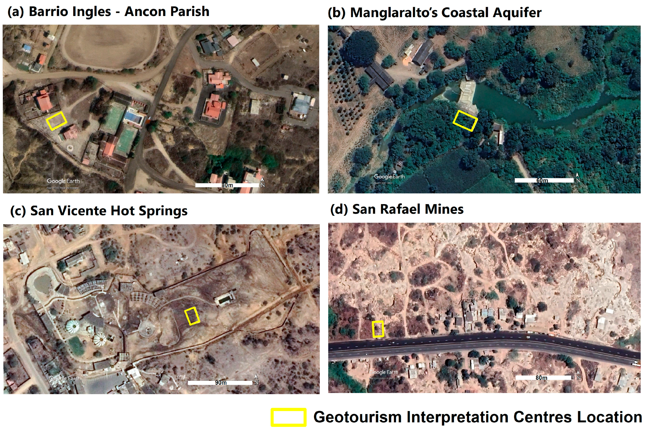
Figure 1. Map of the study area: (a) location of the Santa Elena Province within Ecuador, and (b) cantonal limits of the Santa Elena Province and location of the geosites of the Santa Elena Geopark Project.
Heritage 07 00024 g001
Figure 2. Methodological outline of the study.
Heritage 07 00024 g002
Figure 3. Photographs of the selected geosites: (a) Barrio Ingles Ancon Parish, (b) Manglaralto’s Coastal Aquifer, (c) San Vicente Hot Springs and (d) San Rafael Mines.
Heritage 07 00024 g003
Figure 4. Location of the Geotourism Interpretation Centres within the four selected geosites: (a) Barrio Ingles Ancon Parish, (b) Manglaralto’s Coastal Aquifer, (c) San Vicente Hot Springs and (d) San Rafael Mines.
Heritage 07 00024 g004
Figure 5. Proposed design of the Geotourism Interpretation Centre (GIC). (a) Conceptual diagram showing the three zones: recreational–passive, service and cultural; (b) Plan view showing all areas of the GIC.
Heritage 07 00024 g005
Figure 6. Conceptual scheme of the Geotourism Interpretation Centre.
Heritage 07 00024 g006
Figure 7. Geotourism Interpretation Centre: side view of the architectural plan showing areas, materials and levels (L) considered in the design.
Heritage 07 00024 g007
Figure 8. The proposed 3D design for the Geotourism Interpretation Centre: (a,b) right lateral view and (c,d) cultural and geo-education module (interpretive panels).
Heritage 07 00024 g008
Figure 9. Simplified side view of the Geotourism Interpretation Centre, highlighting air circulation as natural ventilation and the entry of natural light.
Heritage 07 00024 g009
Table 1. Details of the selected sites for the design of the interpretation centres.
Selected SitesDescriptionTourism InformationHeritage Value
Barrio Ingles
Ancon Parish
(Figure 3a)
Site of historical and architectural interest located in Ancon. The neighbourhood has infrastructure dating back to 1911, exhibiting the cultural legacy of the English settlement that began oil exploitation in Ecuador in the city of Ancon [53].The attraction comprises buildings with English-influenced architecture in wood and pumice, oil pumpjacks and proximity to a viewpoint overlooking the sea. In addition, Barrio Ingles encompasses five geosites of varied geological and geomorphological characteristics, such as bituminous exudations, the first Ancon oil well, the Anconcito badlands, Anconcito cliff and Anconcito gypsum veins [54].The cultural legacy of the Barrio Ingles began with the oil history in Ecuador; it is located within the San Jose de Ancon Parish, was declared a Cultural Heritage of Ecuador in 2011, and the cultural wealth is complemented by heritage houses, artisans and “paja toquilla” weavers.
Manglaralto’s
Coastal Aquifer
(Figure 3b)
Geosite of hydrogeological interest located in the parish of Manglaralto. It is the main water supply source for six communes in the parish. Among its secondary characteristics are the ecological and fluvial landscaping of the Manglaralto River [61].The main attraction is the technical–artisanal dam built on the Manglaralto River for damming water and recharging the aquifer. The place has become a site for fishing, recreation and university hydrogeological education [62].It is located in a semi-arid area of the Ecuadorian coast (Santa Elena Province), in which water supply is possible owing to the joint use of surface and underground water through ancient techniques of Water Sowing and Harvesting (WS&H) (e.g., tapes, technical–artisanal dykes and artificial wetlands (“albarradas”)) that guarantee the availability of resources to the community and control the advance of saline intrusion into the aquifer. Since 2007, these techniques have been strengthened with academic intervention (ESPOL University), in which the inclusion of technical criteria has allowed the functionality of WS&H systems to be enhanced in the long term.
San Vicente
Hot Springs
(Figure 3c)
It is a geosite of hydrogeological and petrological interest located in the Baños de San Vicente commune. The place contains hot springs and a mud volcano, both of underground natural origin [48].Since 1922, there has been a tourist complex for using the thermal waters and volcanic muds, which local people consider natural medicinal treatments. The place has an area of 4 hectares. In 2014, it was visited by around 126,000 people [48].San Vicente hot springs is one of the two representative hot spring sites on the Ecuadorian coast; its inhabitants attribute medicinal values to the water and mineralogical content of the volcanic mud typical of the area through hydrotherapy and thermotherapy. This type of activity is aimed at the cure and prevention of physical diseases (inflammation and muscle pain) and mental diseases (stress and anxiety).
San Rafael Mines
(Figure 3d)
It is a geo-industrial type geosite located in the San Rafael canton. It is characterised by presenting rocks typical of the Chanduy-Playas Mountain Range, such as quartzite and granite [54].The largest tourist resource in the area is the granite quarries that expose the natural geology. In the place, you can see the artisanal extraction process of this material [63].Artisanal mining identity of the extraction of stone material is the main source of economic income for approximately 60% of the population.
Table 2. Estimated tourism statistics obtained from the focus group.
ParameterBarrio Ingles (Ancon Parish)Manglaralto’s Coastal AquiferSan Vicente Hot SpringsSan Rafael Mines
Monthly tourist number130020009002300
Visit frequencyMonthlyMonthlyDailyDaily
Estimated stay2 to 3 days2 to 3 daysJust a few hoursJust a few hours
Average expenses per dayBetween $25 and $50More than $50Between $25 and $50Between $25 and $50
Travel reasonsTourism, education, research and workTourism, education and researchTourism, research and healthTourism, education and work
Table 3. Architectural proposal for environmental sustainability.
Environmental SustainabilityProposals
Eco-friendly materials
  • Guadua cane (Guadua angustifolia Kunth bamboo) is proposed as the main structural component of the beams and columns, and as a decorative element on facades and doors.
  • The use of compressed clay/adobe bricks or bahareque is proposed for the service and cultural zones, in finishes with stones from the area, with waterproofing additive.
  • The use of living fences around the interpretation centre using local trees (e.g., Neem) to provide shade and improve the aesthetics of certain sites (e.g., San Rafael Mines) is proposed.
Energy efficiency
  • A semi-open structure is laid out, using wooden sunshades to moderate natural light for lighting (Figure 9).
  • Natural ventilation is emphasized through air circulation, taking advantage of the wind flow through the strategic positioning of the infrastructure (Figure 9).
  • Provision is made for electrical energy, taking advantage of solar energy through photovoltaic systems located on the roof, for the garden lamps in the green areas and the parking bollards (Figure 7 and Figure 8).
Disclaimer/Publisher’s Note: The statements, opinions and data contained in all publications are solely those of the individual author(s) and contributor(s) and not of MDPI and/or the editor(s). MDPI and/or the editor(s) disclaim responsibility for any injury to people or property resulting from any ideas, methods, instructions or products referred to in the content.

