
Outside Inn: Exploring the Heritage of a Historic Hotel through 360-Panoramas

1
Faculty of Science and Engineering, Curtin University, Perth 6102, WA, Australia
2
Creative, University of South Australia, Adelaide 5001, Australia
3
School of Social Sciences, University of Western Australia, Perth 6907, Australia
4
Centre for Digital Humanities Research, Australian National University, Canberra 2601, Australia
*
Author to whom correspondence should be addressed.
Heritage 2023, 6(5), 4380-4410; https://doi.org/10.3390/heritage6050232
Submission received: 23 April 2023
/
Revised: 10 May 2023
/
Accepted: 11 May 2023
/
Published: 18 May 2023
(This article belongs to the Special Issue Photogrammetry, Remote Sensing and GIS for Built Heritage)
Abstract
:This research project investigates the potential of 360-panorama tours to improve the situated and contextual interpretation, virtual visitation, and spatial understanding of recorded or simulated built heritage sites. Our chosen case study was the Subiaco Hotel, a significant heritage building designed by Summerhayes Architecture, which we documented using 360-degree photographs and linked with other media to create an interactive 360-panorama tour. Today, 360-degree panorama tours such as Google Street View enable the virtual exploration of heritage sites and historic buildings. They demonstrate limited interaction and immersion across a range of platforms and devices, without the requirement of expensive virtual reality headsets, but typically do not integrate other media to leverage spatially richer ways to communicate the historical developments of architectural interiors and exteriors. The primary goals of this study were to establish a comprehensive step-by-step workflow for creating an interactive tour of a significant heritage site, demonstrate how other media such as text, videos, and 3D models can be linked, gather feedback from cultural heritage professionals, and offer future research directions and development guidelines. Apart from detailing an optimized workflow for developing interactive 360-degree virtual tours for heritage buildings, we also offer guidelines for optimal panoramic tour creation and implementation.
1. Introduction
A 360° virtual tour is analogous to Google Street View (GSV) for both indoor and outdoor environments. A series of 360° photographs are linked together to allow the online user to virtually ‘walk’ around and discover more about the surrounding spaces than using typical photographs. Using a mobile device, tablet, desktop, or virtual reality goggles, a user can navigate through the tour by simply clicking on ‘hot spots’ within the 360° panoramic photo.
The history of 360-panoramic tours can be traced back to the mid-1990s when the first virtual tour software was developed [1]. At that time, the technology was limited to static panoramic images that could be stitched together to create a 360-degree view of a particular location. With the advent of high-speed internet and advances in camera and software technology, it became possible to create more immersive and interactive 360-panoramic tours [2,3]. A 360° virtual tour provides a unique immersive sensation of “being there” and builds trust and confidence for remote visitors, helping them to interpret the site remotely and hopefully compel them to organize an eventual physical visit/tour [4,5,6].
That said, the 360-pano tour or 360-VR is not true ‘virtual reality’ [7] as it does not support the freedom of movement inside the virtual space and limits the visitors/users to moving only from one point to another point, predicated on where the photo was taken. A pano tour is a good option for applications requiring wider audience reach, more cost-effectiveness, or flexibility, while VR tours are more suitable for applications requiring a higher degree of immersion and interactivity.
The COVID-19 pandemic has had a significant impact and has boosted the use and popularity of 360 VR tours. Studies from Sarkady et al. [8] and Rahim et al. [9] show that, while travel and in-person events have been restricted in many parts of the world, businesses and organizations have turned to virtual experiences to reach their audiences. Subsequently, 360-degree panoramas have appeared as an effective tool for providing immersive and interactive experiences for cultural heritage, tourism [10], and in particular for real-estate visualization [11].
Research has focused on the technical aspects of creating 360-pano tours, such as the use of different camera systems [12] and free stitching software to create high-quality panoramic images [3,13]. Other research has focused on the impact of different design and user interface elements on the effectiveness of 360-pano tours [5,14,15,16]. However, irrespective of their popularity and wide usage, we rarely find studies that compare feature lists of 360-degree pano tour-making software and services; instead they are focused on evaluating the effectiveness of specific software or services for creating and hosting 360-pano tours. Furthermore, it is rare to find papers presenting detailed workflows for developing interactive 360-pano tours, especially with embedded information for more in-depth interpretation.
This paper begins with an in-depth comparative analysis of some popular software and online services available for creating 360-pano tours. Following this, it outlines a comprehensive, step-by-step workflow for developing an interactive 360-panorama tour, using the significant heritage site of the Subiaco Hotel in Perth, Australia as a case study. This study incorporates various interactive features supported by the selected software or tools, embedding relevant information and data to enhance the user’s interpretation and overall experience. As a result, a functional prototype of a multimodal 360-pano tour [17,18] is showcased and examined. Subsequently, the paper delves into the insights and feedback provided by a small group of general users, enriching the understanding of the technology’s implications in this context. Concluding the study, this paper outlines potential future research directions and development guidelines, paving the way for continued innovation and improvement in the realm of 360-pano tours.
2. Background
In the heritage sector, 360-panorama tours (often referred to as 360-pano tours or 360-VR) are a form of immersive technology enabling users to explore a virtual space using 360-degree photographs of a location that are linked together. Users can interact with hotspots within the photos and access additional information through annotations such as text, images, audio, and video. These tours offer a more immersive experience than Google Street View and have potential uses for interpreting heritage buildings and sites.
In this section, we provide an overview of previous studies and research on 360-panorama tours. We conducted a comparative study of different 360-panorama tour software and services and discussed their prominent features and uses with a particular emphasis on heritage interpretation and visualization. Overall, this section aims to provide a comprehensive and up-to-date understanding of the 360-panorama tour landscape, as well as offer key considerations for those looking to utilize this technology in their work.
We do, however, caution that the features listed in the tables are not a comprehensive assessment of all the available options. Additionally, some software may have additional features not listed in the tables or may have been added since the time of our study.
2.1. Overview of Previous Studies and Research
The use of 360-panorama tours in the field of heritage interpretation has received growing attention in recent years, with numerous studies and research projects exploring the potential of this technology. Zeng et al. [5], El-Said et al. [16], and Kim et al. [14] explored the effectiveness of virtual heritage in engaging visitors and enhancing their learning experience, using 360-panorama tours as a case in point. Similar studies have been carried out by various researchers [19], [20] and [21] in museum settings, comparing the use of 360-panorama tours with traditional methods of interpretation, such as audio guides and static images. Shadiev et al. [22] found that virtual reality and 360-degree video applications in cultural tourism increased tourists’ experiential value and satisfaction. Studies [5,12,16,23,24] also suggested that 360-pano tours can be an effective tool for increasing access and engagement with heritage sites.
Authors such as Gafar et al. [25], Barkatov et al. [26], Shadiev et al. [22], and Pereira et al. [27] studied various software and online services in creating 360-panorama tours while exploring their accuracy and usefulness in providing up-to-date information about heritage sites. In most cases, these studies showcase and highlight the positive impact of 360-panorama in delivering valuable insights into better interpretation and engagement of the site [5,24,26,28]. We can also find various studies and reviews of current practices and the exploration of the potentials of some tools [10,22,25], while authors such as Shadiev et al. [22] and Gafar et al. [25] have reviewed the current research on 360-panorama tours.
Studies from Shehade et al. [29], Koehl et al. [30], and Boukerch et al. [3] have described the design and development of a 360-degree panoramic virtual reality system for heritage tourism that links a database of historical information with a 360-panorama tour of a heritage site. However, these studies mostly focused on ensuring the validity of the information rather than reporting any user experience [31] or presenting an optimized workflow. It is rare to have studies presenting a comparison of 360-pano tour software and services and presenting a comprehensive workflow for building interactive 360-VR tours for historic sites in one place. There is also limited research on user feedback and a paucity of useful showcases of audio, video, text, 3D-models, and photos integrated within the 360-panoramic tours.
2.2. The Current State of 360-Panorama Tour Technology and Software
A 360-panorama tour is a popular way to experience virtual tours of various places, including heritage sites and buildings. The technology behind 360-panorama tours involves capturing 360-degree photos and linking or embedding them with data to create an interactive tour experience.
There are several software solutions and online services available for creating 360-panorama tours, including professional tools for photography and multimedia, as well as DIY solutions for individuals and small businesses. These tools vary in their features and capabilities, ranging from basic photo stitching to more advanced options for creating interactive tours. Their ability to annotate text, images, plans, audio, and video within the 360-degree photos provides a rich interpretive layer, making 360-panorama tours a valuable tool for heritage professionals and associates.
One popular software option for creating 360-panorama tours is Adobe Photoshop, which provides advanced photo editing and stitching capabilities. Other software, such as Autopano, PTGui, and Kolor Autopano, also offers 360-pano tour creation, with features ranging from basic photo stitching to more advanced options for creating interactive tours with annotations and multimedia content. Several online platforms allow users to create and share 360-panorama tours, including Google Street View, RoundMe, and Kuula. These platforms offer a range of tools for creating and uploading 360-degree photos, such as annotating and linking them with multimedia content and publishing the final tour for others to explore. In addition to these tools, there are also DIY solutions available for individuals and small businesses, such as the Ricoh Theta camera and app, which allows users to easily capture and publish 360-degree photos and tours. These solutions can be an accessible and cost-effective option for those just starting out with 360-panorama tours.
Overall, the software and platforms involved in creating 360-panorama tours continue to evolve and improve, offering a range of options for different needs and skill levels. The next section of this paper presents a comparative study of some popular 360 software and online services.
2.3. Comparative Study of 360-Panorama Tour Software and Services
To have a clear understanding of the current offerings, we undertook an intensive online search and selected 50 candidates (desktop software and online services) and listed their origin and web address (Table 1). Data from Table 1 gives a snapshot of the 360-degree technology industry and its geographical distribution. Most of the companies are from the United States (14), followed by the UK (4), Canada (4), Spain (2), and other countries (25). This highlights the global reach and popularity of 360-degree technology. Our study also indicates that several companies specialize in particular domains, such as furniture and kitchen visualization (3DCloud), architectural visualization (iGuide), and large infrastructure inspection (OcuMap). Some companies offer services to whole tours by professionals (Paneek) and BIM support (CUPIX).
Next, we selected twenty popular online-based 360-pano tour development and hosting services from Table 1 and listed their offered features and prepared a comprehensive database in Table 2. To conduct the selection, we reviewed user feedback and ratings from diverse platforms, including review websites, forums, and social media. This analysis allowed us to gauge the satisfaction levels and reputation of the shortlisted software solutions. Furthermore, we conducted a comprehensive comparative analysis of the features, functionalities, and capabilities of the shortlisted services. This evaluation enabled us to identify the top twenty software solutions that excelled in meeting our criteria. Table 2 includes the following platforms: Matterport, Orbix360, Kuula, RICOH360, Klapty, Concept3D, CloudPano, My360, EyeSpy360, Virtual Tours Creator, Floorfy, Metareal, Panoroo, WeboBook, TourWizard, Lapentor, TeliportMe, Real Tour Vision (RTV), EvryPlace, and VTILITY.
Table 2 showcases a vibrant ecosystem of solutions catering to a broad spectrum of user requirements and budgets. Many of the platforms support common image formats such as JPG, PNG, and BMP, but there are some differences in the types of 360-degree images that are supported. ORBIX360 stands out for supporting stereoscopic/3D images, while CloudPano supports animated GIFs and MP4 videos. Both Matterport and Kuula support an extensive range of image formats, and are compatible with a variety of 360 cameras, including popular models such as the Ricoh Theta and Insta360.
These platforms also provide numerous customization features, enhancing the user experience and increasing the engagement of virtual tours. For example, password protection allows creators to control access to their tours, while embedded multimedia elements such as voice, music, text, photos, URLs, and videos can enrich the content and make it more immersive. Additionally, users can incorporate floor plans and contact information, giving potential clients a comprehensive understanding of the property or location being showcased.
Many virtual tour platforms offer a range of additional features, such as hotspots (interactive elements that users click on to access more information or navigate to different areas within a virtual tour), floor plans, and virtual staging (digitally furnishing and decorating empty spaces or existing rooms in a virtual tour to make them visually appealing and help viewers envision the possibilities). When choosing a platform, it is important to consider which features are most valuable for your needs. Custom branding (incorporating a company’s or individual’s brand elements into the virtual tour to maintain a consistent brand identity and create a professional look) and white-labelling (removing or replacing the default branding of the virtual tour software or platform with the user’s own branding for a customized appearance) options, for example, are available with software such as Concept3D, enabling users to tailor the appearance of their virtual tours and host them on their own domains. Virtual staging services, provided by platforms such as Klapty, allow users to digitally furnish spaces, helping potential buyers or renters to visualize the possibilities. Interactive floor plans, offered by CloudPano and Floorfy, enhance spatial understanding while leading generation tools from Real Tour Vision and Virtual Tours Creator capture viewer contact information. Custom hotspots, as featured in Metareal and Lapentor, enable further exploration within the virtual tour, while live virtual tours, such as those offered by EyeSpy360, provide personalized experiences even when in-person visits are not possible.
Advanced features such as dollhouse views (3D representations of the entire property or area, providing a unique perspective by displaying the structure as if it were cut open, allowing viewers to see the spatial arrangement and layout) and measurement tools are also available on some platforms, further elevating the virtual tour experience. For instance, Matterport’s 3D dollhouse view provides users with a unique, interactive perspective of a space, while platforms such as Zillow 3D Home include measurement tools to help users gauge the dimensions of rooms and objects accurately.
Export file formats are diverse among these platforms, with many of them supporting HTML5, direct links, embed links, and social media sharing options. This flexibility allows users to share their virtual tours in multiple ways, increasing their reach and engagement. The majority of these platforms are compatible with a wide range of devices, including smartphones, tablets, and computers, ensuring that users can access, create, and share their virtual tours seamlessly across multiple platforms. This cross-device compatibility is crucial in today’s interconnected world, as it allows potential end users to explore virtual tours anytime and anywhere.
It is also evident from Table 2 that the fees charged by the virtual tour software vary greatly, ranging from $0/month to $333/month. For example, Virtual Tours Creator charges $19.99/month for its self-capture plan, while Real Tour Vision (RTV) charges $219 for its Software+10 credits plan. Similarly, fees for hosting services also vary, with some software providing a limited amount of storage for free, while other charges are based on the amount of storage used. For instance, CloudPano offers a basic package at $37 per month (while writing this paper), making it accessible to smaller businesses and individual users, while Concept3D’s pricing starts at $1,500 per year, catering to larger enterprises or more demanding use cases. In conclusion, the pricing and hosting service offered by virtual tour software depends on the specific software, and the needs and budget of the user should be taken into consideration when choosing a virtual tour software.
Similarly, we included eight popular desktop-based software candidates, i.e., 3DVista, Pano 2 VR, PanoramaStudio, Revvis, Envisioneer, Glo3D, Krpano, and Tourweaver, in Table 3, which provides a comprehensive comparison of various virtual tour software platforms, highlighting their general features, pricing, and capabilities.
All software programs support most camera types. In terms of supported file formats for importing, 3DVista can import JPG/JPEG, PNG, BMP, TIFF, and GIF files, as well as Live Panoramas and Adaptive HDR. Pano 2 VR supports JPEG, PNG, TIFF, PSD/PSB, OpenEXR, RGBE, MP4, and MOV. Besides JPG, TIFF, BigTIFF, PSD, BMP, PNG, and WEBP, PanoramaStudio 3 claims that they support more than 1180 RAW formats.
Regarding projected file formats, 3DVista supports 18 types, including equirectangular, cubic, rectilinear, cylindrical, fisheye, Mercator, and Albers equal area conical, among others. Pano 2 VR supports flat, cylindrical, spherical, perspective, stereographic, and fisheye projections. PanoramaStudio 3 supports cylindrical, spherical, and perspective projections. Revvis provides a first-person view, 3D view, plan view, and VR headset view. Krpano and Tourweaver do not provide enough data on projected file formats.
When it comes to adding various information/data to virtual tours, such as floor plans, contact information, voice/music, text, photos, URLs, and videos, the platforms offer a range of options. It seems that “3DVista" and “Pano 2 VR" both offer a wide range of features and support for different file types, including the ability to embed photos, texts, voice/music, URLs, and videos. They both also allow for embedding to a website through HTML 5 or WordPress. On the other hand, “PanoramaStudio" and “Revvis" appear to have limited features, with no ability to add contact information or embed videos.
Regarding other features, many software programs offer unlimited upload limits and allow for embedding tours onto websites. Some software programs, such as Krpano and Tourweaver, support dollhouse/axonometric views. Glo3D and Envisioneer offer photo enhancement tools, while others, such as Pano 2 VR and Tourweaver, allow for embedding voice/music and videos. Additionally, some software programs, such as 3DVista and Pano 2 VR, are compatible with VR headsets, while others, such as Revvis and Krpano, offer different viewing modes.
Prices for these programs vary, with some offering a 30-day free trial followed by a one-time fee for unlimited tours, while others operate on a subscription basis. Envisioneer offers several pricing plans depending on the user’s needs, ranging from a low-cost Personal Architect version to a more expensive Construction Suite version. Tourweaver has four different versions ranging in price from $699 to $1299. Hosting fees also vary, with 3DVista charging 99€/year and PanoramaStudio charging $69 for single-domain hosting and $199 for multi-domain hosting.
Overall, each platform has its own strengths and weaknesses, and the right platform for a given use case will depend on the specific needs and requirements of the user. It is important to carefully evaluate each platform and consider factors such as cost, supported file formats, camera support, and tour customization options when making a decision.
2.4. Linking Data or a Database with a 360-Panorama Tour
The diverse methods of linking a database with a 360-panorama tour enable the creation of rich and immersive experiences for users. API Integration serves as an effective approach for seamless data exchange, particularly when the database is hosted on a separate server or platform [32,33]. Embedding Database Content is suitable when the database and the tour are hosted on the same server, allowing for the direct access and display of the data [34,35]. However, database queries used to access large and complex databases require advanced programming skills. Interactive Map Integration and CSV or Spreadsheet Integration provide additional layers of interactivity and information display [36,37]. Virtual Reality Integration offers immersive exploration experiences, while Interactive Tour Stops provide context-specific information through multimedia elements and external web links [38]. Each method’s suitability depends on the type of database, the amount of data to be displayed, and the desired user experience.
2.5. Discussion
Our comparative study of various software and services demonstrated that a vibrant ecosystem of solutions has emerged, catering to a wide array of needs, budgets, and skill levels. This comparative study examined 50 360-panorama tour software and services, assessing their features, pricing, and capabilities. Key findings include the widespread support for common image formats and cameras, as well as a variety of customization and advanced features that enhance user experiences. Cross-device compatibility is essential, and most platforms work seamlessly across various devices. Pricing and hosting services vary greatly, depending on the specific software and user needs. Therefore, users must evaluate each platform based on factors such as cost, supported file formats, and customization options to determine the best solution for their requirements. Furthermore, linking a database with a 360-panorama tour highlighted the importance of providing rich and context-specific information to enhance the user experience. However, it is important to scrutinize the ease of use, scalability, and compatibility of these methods with various software and platforms.
The 360-panorama tour technology and software landscape presents a wealth of opportunities for creating captivating virtual experiences. Nevertheless, it is essential to critically examine the offerings, their accessibility to different user groups, and the potential for further innovation and collaboration to drive the industry forward and ensure that the technology’s full potential is realized.
3. Methodology
3.1. Site Selection
This study is part of a larger project, the Australian Cultural Data Engine (https://www.acd-engine.org/, accessed on 5 December 2023). The overall project aims to showcase the linking of cultural data with the power of computation. Curtin University was a partner, and our aim was to showcase the potential of digital media to augment traditional library archives of digital photographs. Curtin University Library has approximately 500 drawings and 1500 photographs of buildings by three generations of the Summarhayes family, a leading West Australian architectural firm, and the library has plans to digitalize the special collection to improve its accessibility [39,40].
Our goal was to showcase the usefulness of panorama tours in presenting the spatial and chronological context of buildings and interiors through the integration of different media with 360-degree photographs. Digital panoramas can integrate and juxtapose different media and sources, as well as more intuitively and immersively link spaces, be they interior spaces or exterior ones, with various modes of cultural data. This may be of particular use in displaying spatial media from different eras in more quickly understandable chronological and spatial contexts.
Given the above, the Subiaco Hotel in Perth is the perfect choice for our project on the impact of 360-pano tours on heritage understanding and preservation. This iconic heritage building, built in the 1890s and designed by Summerhayes Architecture, holds great cultural and historical significance [41]. The hotel was built in the late 19th century and is one of the oldest remaining buildings in Subiaco, an inner-city suburb of Perth. The hotel was designed in the Federation Free Classical style, which was popular in Australia during the late Victorian and Edwardian eras. This style is characterized by classical architectural elements such as columns, pediments, and balustrades, combined with decorative features such as stained glass and ornate plasterwork. The Subiaco Hotel’s architectural style is widely recognized and praised by experts in the field, making it a noteworthy example of its kind. The hotel’s historical significance and unique design contribute to its significant heritage value, making it an important cultural landmark in Perth [42].
In addition to its architectural significance, the Subiaco Hotel is also historically important. The hotel has been in continuous operation since it was built (in 1897 or earlier) and has played a significant role in the social and cultural life of the local community. It was a popular gathering place for residents and was known for hosting events such as dances, parties, and other social gatherings. In 1994, the Subiaco Hotel was officially recognized for its cultural and historical value when it was listed on the Western Australian Heritage Register [43]. This designation highlights the building’s importance as a symbol of Perth’s rich heritage and recognizes the need to preserve its original form and protect its significance for future generations.
3.2. Documentation with 360 Photography
The documentation of the Subiaco Hotel in Perth, Western Australia, was carried out using 360-degree photography and the Theta X camera. The camera was set to HDR mode, which allowed for the capture of a broader range of light and color, providing vivid and detailed images. The time-shift mode provided by the software was utilized to eliminate the presence of the photographer in the photos. This mode was convenient for the documentation process as it allowed for the creation of panoramic images without any obstructions. However, the time-shift mode had a drawback, as it only produced internally stitched JPEGs, and no raw files were produced. This limitation restricted the options for color correction during post-processing and could have impacted the final quality of the images.
Despite the limitations of the time-shift mode, over fifty 360-degree panoramic photos of both the interior and exterior of the Subiaco Hotel were created. This comprehensive set of images provides a thorough visual record of the building’s architectural and cultural significance and necessary information for the next step.
3.3. Post-Processing
The post-processing of the 360-degree panoramic photos of the Subiaco Hotel was a crucial step in ensuring the visual quality and accuracy of the final product. A total of over 50 photos, both interior and exterior, were taken using a Theta X camera with HDR mode enabled. The camera generated jpeg images with a resolution of 11,008 × 5504 pixels and 200 DPI. The post-processing of these images involved 5 key steps, including color correction, NADIR/tripod removal, denoising, up-scaling, and final export in a pano tour compatible format with Exif data.
The photos were first transferred to a computer using the camera’s native software, ’Ricoh Theta File Transfer for Mac’. The initial step of post-processing was performed using Adobe Lightroom, where the photos were white-balanced and color-corrected, and necessary adjustments were made to exposure, highlights, dehaze, and vibrance. In the next step, the photos were taken to Adobe Photoshop for NADIR correction, which involved manual patching and export of each photo as a jpeg image.
To remove the significant noise present in the images, the photos were then processed using Topaz’s Denoise software in standalone mode with the standard AI model and manual adjustments. The processed images were then up-scaled to 8K resolution (16,384 × 8192 pixels) using Topaz’s GigaPixel software, where the Standard AI model (default) with some sharpness was applied. Finally, the photos were imported to Adobe Lightroom again, reduced by 20% in size, and exported as jpeg files. We found this setting significantly reduces the file size of the panoramas while making any noticeable impact on the color and quality with naked eyes.
The image editing process was carried out systematically, and Figure 1 demonstrates the steps involved in the process. This comprehensive post-processing approach ensured that the final product was of the highest quality and accuracy, providing a visually stunning interpretive 360-pano tour of the heritage-listed building, the Subiaco Hotel.
3.4. Selection of the 360-Pano Tour Development Software
In our study, the selection of the 360-pano tour development software was a critical aspect, driven by our specific goals of creating an interactive tour of a significant heritage site and demonstrating the seamless integration of various media elements such as text, video, audio, and 3D models to enhance the user’s interpretation and experience.
After conducting a thorough evaluation, we identified 3DVista as the preferred software solution due to its exceptional features and capabilities. Firstly, the offline working option offered by the platform allowed us to create and edit virtual tours without the need for an internet connection. This flexibility greatly facilitated our workflow. Furthermore, the ability to export tours as executable files simplified the sharing and distribution process, ensuring widespread accessibility. 3DVista’s support for 3D model integration was another compelling factor, enabling us to showcase linked 3D models from Sketchfab within our virtual tours. Additionally, the software provided features such as ‘virtual staging’, allowing us to illustrate thematic changes in the space over time, further augmenting the tour’s narrative and helping to showcase the historic value of the building.
The capability of creating customized hotspots and pop-up information windows within 3DVista was invaluable. These interactive elements help to provide additional context and details and can foster exploration and deepen user understanding of the heritage site. Additionally, the one-time purchase model and bundled feature set offered by 3DVista not only provided significant value but also resulted in cost savings, making it an appealing choice for our study.
By combining a one-time purchase model with extensive features, including offline working capabilities, export options, 3D model integration, virtual staging, custom hotspots, and pop-up information windows, 3DVista proved to be an excellent solution for creating high-quality virtual tours for our project.
3.5. Interaction Design and Development of the VR Tour
3DVista allows both stitched and unstitched images. As we have already prepared the stitched images, there are five basic steps to develop the interactive tour with 3DVista, i.e.:
3.5.1. Import the Stitched Images into 3DVista
The import function in 3DVista allows adding various types of media files to a project, such as panoramic photos, regular photos, videos, audio files, and more. To import stitched images into 3DVista, click on the “Import" button and select the panoramic image file. User should note here that the photos need to be in the form of equirectangular or cubemap images with a 2:1 aspect ratio. Supported file types include JPG, PNG, and TIFF. 3DVista can also import audio (MP3, WAV, and OGG), video (MP4, AVI, and MOV), and 3D models (OBJ, FBX, and DAE).
3.5.2. Add Hotspots
Hotspots are interactive elements that link different panoramic photos together to create a seamless navigation experience. They also allow users to click on different parts of the panorama and explore them in more detail. By clicking on the “Hotspots” button and selecting the type of hotspot, it is possible to add text, images, videos, and other multimedia elements to the hotspots, and also customize their appearance, behavior, or properties. By using hotspots creatively, one can enhance the visual storytelling of the tour and guide the audience through it. Adding hotspots can make the 360-pano tour more engaging, interactive, and memorable for the audience.
3.5.3. Customize the Tour
Customizing the tour in 3DVista is an important step to enhance the user experience and create a unique 360-pano tour. First of all, we added text, images, and other multimedia elements to the tour hotspots to allow additional information, such as descriptions, captions, 3D models, and multimedia content, to enhance the user’s understanding and enjoyment of the tour. We also added background music to set the mood of the tour and tried to offer a more immersive experience. Moreover, we customized the tour’s appearance and style by using specific themes, color schemes, and layouts.
3.5.4. Preview Your Tour
The preview phase is an important step in creating a 360-pano. During this phase, we previewed and tested the tour to ensure that everything works as expected and that the user experience is optimal. Clicking on the “Preview” button in the toolbar opens a new window that shows a live view of the tour. From there, it is possible to navigate through the tour, test the hotspots and multimedia content, and make any necessary adjustments. Preview mode also allows the testing of the tour on different devices and platforms to ensure that it is optimized for different screen sizes and resolutions and cross-browser compatibility.
3.5.5. Publish the Tour
Exporting a 360-panoramic tour from 3DVista is a straightforward process that involves converting the tour from the software format into a format that can be easily viewed and shared. 3DVista allows publishing the tour as a standalone executable file or as an HTML5 file, or uploading it directly to a website, to YouTube (360 videos), or the 3DVista cloud hosting service. The standalone executable file (.EXE for PC and .Dmg for Mac) allows the distribution of the tour as a standalone application that can be downloaded and installed on a computer. This file type is suitable for offline use and can be customized with its own branding elements. On the other hand, the HTML5 file (.html) allows the publishing of the tour online and sharing it with audiences via a web browser without requiring any download. 3Dvista also allows uploading the tour directly to a website using FTP or a web hosting service.
4. The Prototype
For the prototype development, we utilized 10 panoramic photos (out of 50) to create a comprehensive tour that integrates various information and media files, including text, images, drawings, PDFs, audio, video, and 3D models.
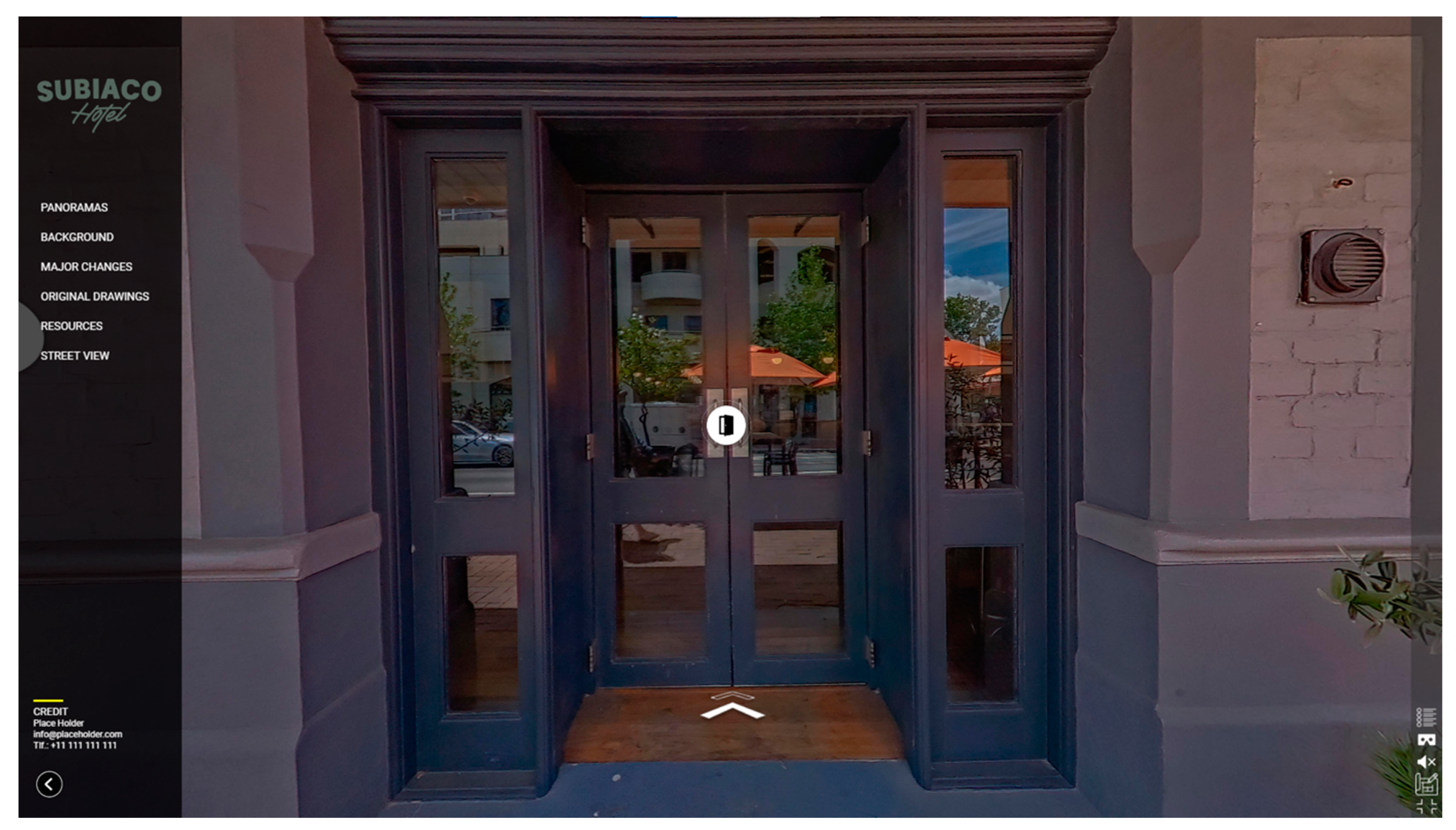
Upon accessing the virtual tour online or through the executable file, viewers enter the tour at the main entry point of the Subiaco Hotel. The user interface features a left-side menu with options such as Panoramas, Background, Major Changes, Original Drawings, Resources, and Street Views, all of which are self-explanatory. Additionally, five icons are located in the bottom-right corner, providing users with options to enable HMD mode, toggle sound on/off, view drawings, enter full-screen mode, and access details (Figure 2).
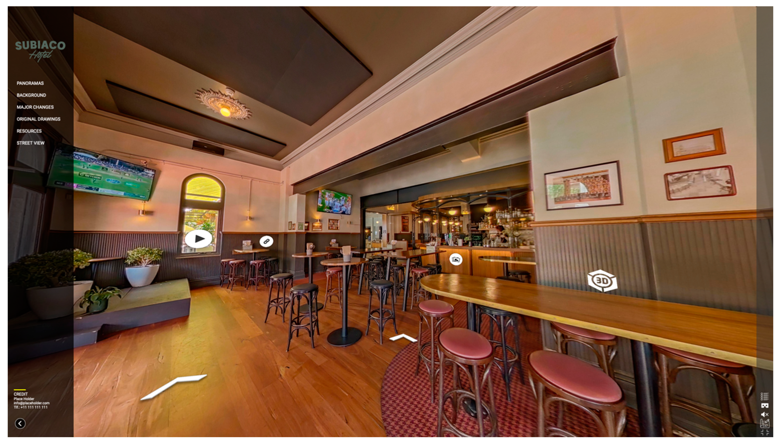
By clicking on the animated icon on the floor or selecting any hotspot icons, viewers can begin navigating the tour and move from one space to another. The floating icons or hotspots are self-explanatory and connected to relevant data and digital resources. For instance, clicking on an icon representing a link, PDF, video, 3D model, or image will open a pop-up window, displaying the associated data and information (Figure 3). In this prototype, video and 3D model content are dynamically linked via YouTube and Sketchfab, while other files and data, such as info, photos, and PDFs, are hosted locally. Please note that as a consequence of logistical issues during the prototype’s development, we could not obtain digital copies of the original drawings and images; therefore, similar old drawings and photos have been used as placeholders.
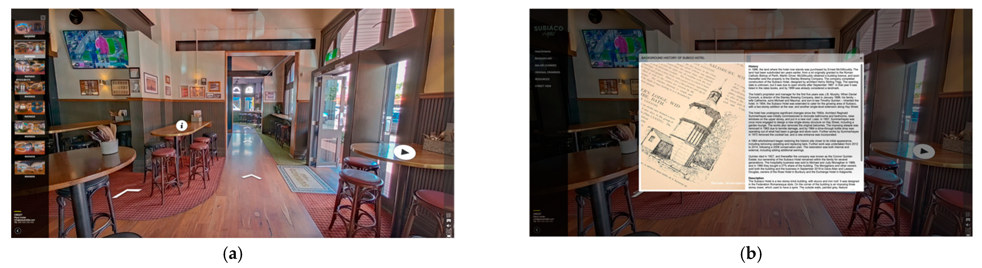
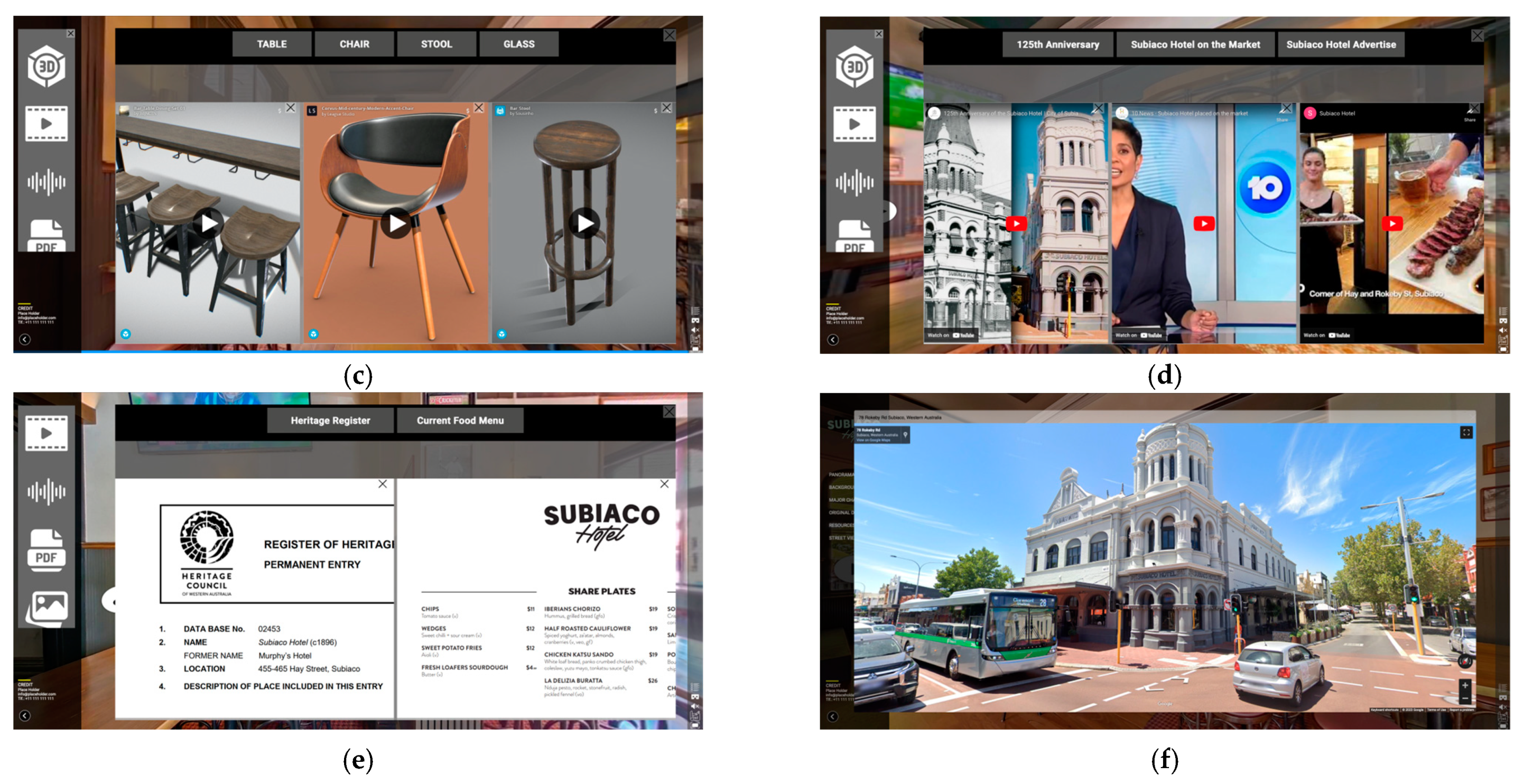
The left Panoramas button opens a slider displaying the 360-degree photos used for this tour. Users can navigate and jump directly to a specific point by clicking on the corresponding photo (Figure 4a). The Background button opens a pop-up window showcasing the hotel’s history, accompanied by sliding/animated old photos (Figure 4b). Similar to the Panoramas button, the Original Drawings button unveils another slider, so that users can click on thumbnails to enlarge specific images or drawings. The Resources button, on the other hand, opens a media gallery containing 3D models, videos, audio files, PDF files, and photos. Each group opens new windows, showcasing their respective libraries (Figure 4c, 4d, 4e). For example, Figure 4c shows the 3D gallery and its respective library, where the 3D contents are pulled/linked from Sketchfab’s depository. The Street View button transports the user to Google Street View, enabling them to explore the surrounding streets and observe the building within its historical context, providing a better understanding of the streetscape (Figure 4f).
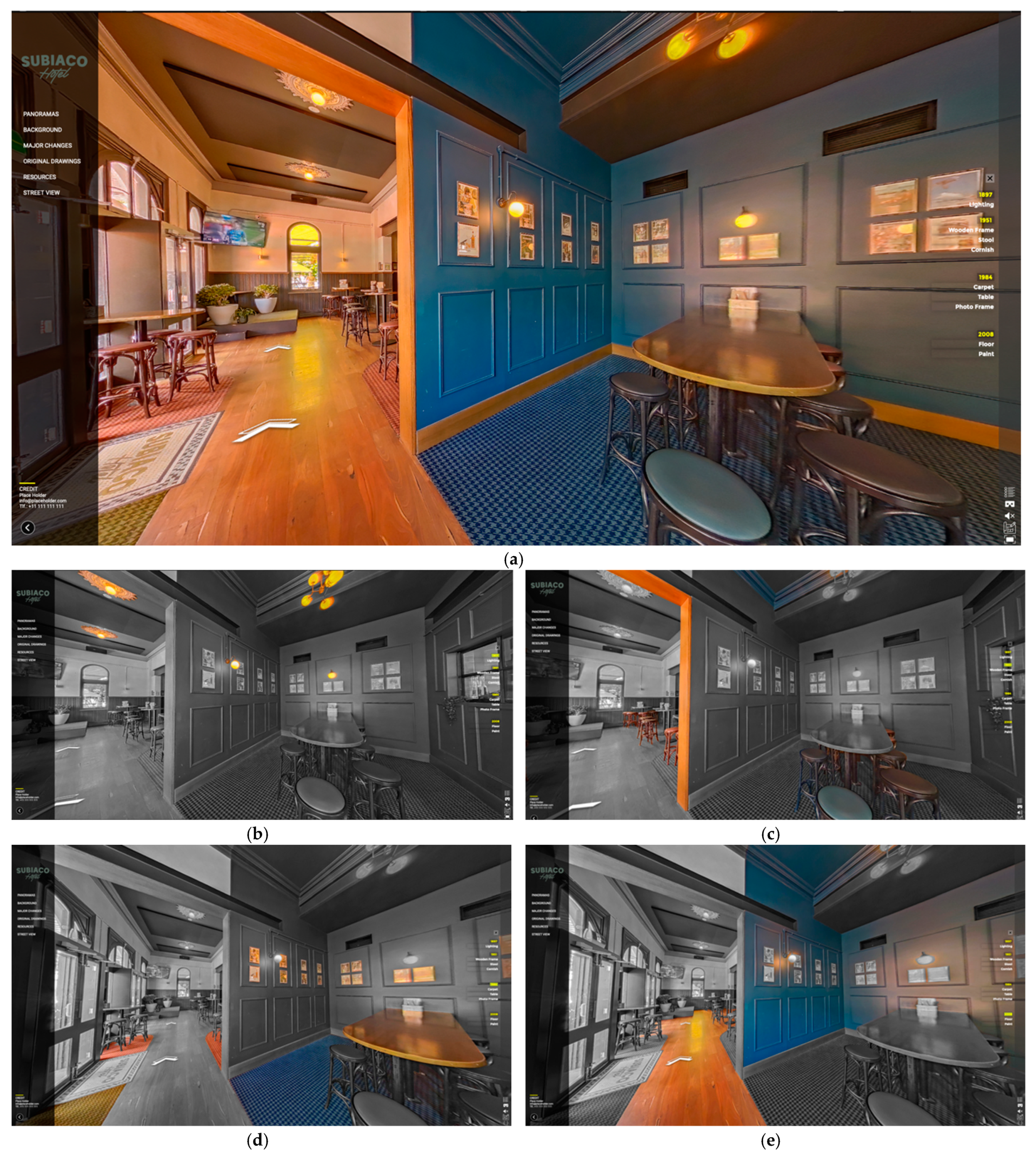
One of the most captivating features of this pano tour is the interactive visualization of the building’s thematic changes over time, which can be accessed through the Major Changes button. Clicking on this button transports the viewer to a specific location within the hotel and a date slider appears on the right side of the interface (Figure 5). Viewers can select a date/time to see the changes that occurred in that space/location over time. The installed items/materials will be highlighted (colored), while the remainder will be greyed out. Simultaneously, the viewer can move, zoom, and rotate the view in 360 degrees. This will assist the viewers in interpreting the historical significance of the building while knowing the authenticity vs intrusiveness of the building materials and installations over time. (Please note that the changes are not historically authentic and are created only to serve as a proof of concept).
In conclusion, the prototype developed for the Subiaco Hotel virtual tour offers a comprehensive and interactive experience that effectively integrates various information and media files. The user interface is intuitive and user-friendly, with self-explanatory menus and icons that guide viewers through the tour. Hotspots seamlessly connect the viewer to relevant data and digital resources, while various buttons provide quick access to panoramas, background information, original drawings, and other resources. The interactive visualization of the building’s thematic changes over time is a particularly captivating feature that enhances the overall experience. Although the prototype has some limitations, such as the use of placeholder images, it serves as a solid proof of concept, demonstrating the potential for a truly immersive and informative virtual tour.
However, during the exporting process, we encountered compatibility issues and occasional software crashes. Sometimes, incorrect export settings resulted in poor resolution or large file sizes, leading to a lower quality tour or to longer load times. If hotspots or linked scenes are not properly set up, they may not work as intended when the tour is exported. Software glitches can also cause the tour to crash or prevent it from being exported correctly. Lastly, the exported file size is another issue, as it may take too long to load or be inaccessible on certain devices. We are currently working on fixing and improving these issues.
Overall, it is crucial to carefully preview the tour and test it thoroughly before exporting to ensure that all elements are functioning as intended. If any issues are encountered, they should be addressed before the tour is exported to minimize the risk of problems when it is published.
5. Discussion
This study aimed to develop an interactive 360-pano tour while presenting an optimized workflow and at the same time providing feedback on the suitability of these interpretive tours for a richer understanding and appreciation of historical sites and for improved decision-making by heritage professionals and associates.
5.1. Software Is Evolving with New Features
The 360-pano software landscape has undergone significant advancements in recent years, fueled by the rapid progress of new technologies and the growing demand for immersive experiences [12]. These advancements have led to improved image quality and resolution, facilitated by state-of-the-art camera technology and advanced image processing algorithms [26]. A comparative study of 50 desktop software and online services catering to various needs and skill levels found that each platform possesses unique strengths and weaknesses. To stay competitive, these platforms are continuously evolving and frequently introducing new features. While professional photography software such as Adobe Photoshop and online platforms such as Google Street View, RoundMe, and Kuula offer diverse options for different needs and skill levels, the quality of the resulting tour can vary based on the platform used.
The incorporation of depth information and 3D mapping has further enriched the realism and spatial awareness in 360-pano tours [44], while the integration of laser scanning technologies and 360º photography enables more accurate digital documentation [45]. Additionally, the application of artificial intelligence (AI) streamlines the stitching process [46], and the use of NeRF (Neural Radiance Field) models assists in developing scene geometry from 360-panoramas. These emerging developments suggest that 360-pano software will continue to deliver increasingly sophisticated and engaging virtual tours in the future.
5.2. Comparative Study and Finding the Best Solution
The 360-panorama tour industry presents a diverse array of software and platforms designed for creating and hosting immersive virtual tours. Our comprehensive study of 50 desktop software and online services catering to various needs and skill levels highlighted that each platform possesses unique strengths and weaknesses, emphasizing the importance of the careful evaluation of specific requirements to select the most suitable solution.
Our investigation uncovered numerous desktop software and online services targeting different needs and skill levels, with specialized companies focusing on niche areas such as furniture and kitchen visualization, architectural visualization, and large infrastructure inspection. It is evident that VR and 360-degree technology have a global reach, with the majority of companies based in the US, followed by the UK, Canada, Spain, and other countries. This study also demonstrated that pricing, hosting services, and features, including multimedia content integration and tour customization, vary depending on the chosen package or service. A thorough assessment of individual requirements is crucial for selecting the most appropriate platform. Furthermore, despite the global expansion of VR and 360-degree technology, occasional bugs and glitches may still affect the final quality and export of the 360-panorama tour.
It is important to note that our findings are based on the features listed in Table 2 and Table 3 during our survey for this paper and may not provide a comprehensive assessment of all available options. Furthermore, more recent software updates may have added new features that were not available at the time of our survey (last quarter of 2022).
5.3. Issues Regarding 3DVista
While 3DVista offers a range of advanced features, users should consider technical limitations, file management, customer support, and competition from other software options. One advantage of 3DVista is its user-friendly interface, which allows users to easily create and customize their tours. The software also offers various multimedia options for enhancing the tour experience, including the ability to add audio, video, and other interactive elements to hotspots, as well as customization options for tour design such as changing the background music, tour speed, and overall appearance.
However, when using 3DVista for creating 360-panorama tours, users should be aware of file management challenges. Each project can generate a large number of files, including individual images, audio files, and other multimedia elements, so users need to have a plan in place for organizing and backing up their files to prevent confusion and loss of data. Bugs may also create issues for the software’s rendering capabilities, alignment issues between individual images, and other technical issues that can impact the final quality and export of the 360-panorama tour. Users should be aware of these potential issues and stay up-to-date with software updates and bug fixes to ensure the smoothest possible experience. It is also important for users to regularly save and back up their work to avoid the loss of data in the event of a software malfunction.
5.4. User Feedback
The prototype was demonstrated to a small group of colleagues in the area and their general user feedback was collected. Overall, users had a positive impression of the 360-panoramic tours of historic buildings. They found the tours engaging and valuable as educational and interpretative tools, which helped enhance their understanding and appreciation of the structures.
Moreover, users appreciated the opportunity to experience the buildings more personally, and to be able to view historical artefacts or scholarly arguments in spatial and chronological context through the integrated information (photo, video, 3D, etc.) into panoramas of the existing building framework. Having a detailed view of a specific object with a zooming option impressed them. They also viewed the tours as effective tools for the conservation and promotion of historic buildings, highlighting the potential to raise awareness about the importance of preserving such structures while encouraging general people to actively participate in their protection and conservation. Nevertheless, users identified several critical aspects and issues, including:
- Lost in space: There was no help or tutorials. They asked for a dollhouse or navigation plan/map views where they can locate themselves in the map.
- Technical limitations: Slow loading times were reported by some users, which negatively affected their experience.
- Lack of interactivity: A few users criticized the passive nature of the experience, noting that the level of interactivity and freedom of movement was limited compared with Virtual Reality.
- Inaccuracies: Some users pointed out inaccuracies in the information presented in the 360-panoramic tours, such as the use of mock or placeholder images instead of original photos and media.
- Limited accessibility: The 360-panoramic tour was restricted to ten spots; most of the users wanted a more comprehensive tour of the entire building.
Despite these criticisms, the 360-panoramic tour of the historic Subiaco Hotel was generally well-received by users. They found it to be a valuable educational tool that helped enhance their understanding of the history and significance of the building.
5.5. External Data Integration
Incorporating external data into 360-panoramic tours of heritage buildings necessitates striking a balance between delivering valuable information and preserving the immersive nature of the tour. Our study was limited by the features of 3DVista and the data integration options provided by the platform/software. Although there may be alternative methods for integrating external data, such as API, embedding databases, or CSV integration, these approaches often require advanced programming and technical skills.
The quality and relevance of the external data play a pivotal role, as low-quality or unrelated information may diminish the overall experience. Furthermore, accessibility factors, such as audio descriptions or subtitles, must be taken into account. While external data can enrich users’ understanding of the building and its history, an excessive amount of information may overwhelm them and detract from the immersive quality of the tour. As a result, careful consideration and planning are essential for the successful integration of external data into 360-panoramic tours of heritage buildings, ensuring that the tour remains informative and enjoyable for all users, regardless of the integration methods employed.
6. Closing Thoughts and Reflections
This research provides valuable insights into the development and application of 360-panorama tours for heritage interpretation. Panoramas can provide a more engaging and spatially intuitive linking of different media, be they archival, digital simulations, or artistic renderings. By establishing a comprehensive step-by-step workflow, this study demonstrates how these interactive tours can effectively convey the significance and history of heritage sites, such as the Subiaco Hotel. The feedback from cultural heritage professionals serves as a testament to the potential of 360-panorama tours in enhancing the understanding and appreciation of these sites.
The discussion section highlights the importance of software selection, addressing the various strengths and weaknesses of different platforms, as well as the need to consider technical limitations and file management. Despite some limitations, such as loading times, interactivity, and accessibility, user feedback underscores the value of these virtual tours as educational and interpretive tools. Automating, the integration of external data with panoramas through the Semantic Web (and Linked Open Data), is a critical next step, but researchers will need to strike a balance between informative content, flexible data streams, and preserving the immersive experience.
We also suggest that future research should concentrate on enhancing user experience and leveraging artificial intelligence algorithms to automatically search, link to, and provide potentially related external media. These developments will be pivotal in improving the scholarly usefulness and pedagogical richness of multimodal panoramic tours.
In conclusion, this study not only provides a valuable framework for creating 360-panorama tours but also paves the way for future developments in virtual heritage interpretation and decision-making processes. With the optimized workflow and guidelines presented in this research, we believe that this innovative approach to heritage interpretation will gain wider adoption, ultimately benefiting both decision-makers and the general public. As 360-panorama tours continue to evolve, we anticipate further advancements in virtual heritage interpretation, leading to more engaging and immersively situated experiences for scholars, practitioners, and the general public.
Supplementary Materials
The following supporting information can be downloaded at https://www.mdpi.com/article/10.3390/heritage6050232/s1, Table S1: List of 360-panorama tour software and Services. Table S2: Online-based 360-pano tour services. Table S3: Desktop-based 360-pano tour software.
Author Contributions
Conceptualization, H.R. and E.C.; Methodology, H.R. and E.C.; Software, H.R.; Investigation, H.R. and D.M.; Resources, D.M.; Writing—original draft, H.R.; Writing—review & editing, E.C. and D.M.; Visualization, H.R.; Supervision, E.C. and D.M.; Project administration, E.C. and D.M.; Funding acquisition, E.C. and D.M. All authors have read and agreed to the published version of the manuscript.
Funding
This research was funded by Australian Research Council, grant number LE210100021.
Data Availability Statement
Not applicable.
Acknowledgments
This study was conducted by Curtin University and University of South Australia-associated academics as part of the larger Australian Cultural Data Engine project, funded by the Australian Research Council Linkage Infrastructure, Engineering and Facilities Program Grant LE210100021. We would like to thank the Subiaco Hotel management for access to the hotel, and to Curtin University Library for access to the digital collection of Summerhayes Architecture.
Conflicts of Interest
The authors declare no conflict of interest.
References
- Kingstone, H. Contemporary History in Panoramas. In Panoramas and Compilations in Nineteenth-Century Britain: Seeing the Big Picture; Macmillan, P., Ed.; Springer Nature: Berlin, Germany, 2023; pp. 27–61. [Google Scholar]
- Berkman, M.I. History of Virtual Reality. In Encyclopedia of Computer Graphics and Games; Lee, N., Macmillan, P., Eds.; Springer Nature: Berlin, Germany, 2018; pp. 1–9. [Google Scholar]
- Boukerch, I.; Takarli, B.; Saidi, K.; Karich, M.; Meguenni, M. Development of panoramic virtual tours system based on low cost devices. Int. Arch. Photogramm. Remote Sens. Spat. Inf. Sci. 2021, 43, 869. [Google Scholar] [CrossRef]
- Teo, T.; Norman, M.; Lee, G.A.; Billinghurst, M.; Adcock, M. Exploring interaction techniques for 360 panoramas inside a 3D reconstructed scene for mixed reality remote collaboration. J. Multimodal User Interfaces 2020, 14, 373–385. [Google Scholar] [CrossRef]
- Zeng, Y.; Liu, L.; Xu, R. The Effects of a Virtual Reality Tourism Experience on Tourist’s Cultural Dissemination Behavior. Tour. Hosp. 2022, 3, 314–329. [Google Scholar] [CrossRef]
- McLean, G.; Barhorst, J.B. Living the experience before you go... but did it meet expectations? The role of virtual reality during hotel bookings. J. Travel Res. 2022, 61, 1233–1251. [Google Scholar] [CrossRef]
- Milgram, P.; Kishino, F. A taxonomy of mixed reality visual displays. IEICE Trans. Inf. Syst. 1994, 77, 1321–1329. [Google Scholar]
- Sarkady, D.; Neuburger, L.; Egger, R. Virtual reality as a travel substitution tool during COVID-19. In Proceedings of the Information and Communication Technologies in Tourism 2021, online, 19–22 January 2021; Springer International Publishing: Cham, Switzerland, 2021; pp. 452–463. [Google Scholar]
- Rahim, N.; Nasaruddin, N.; Shah, N.; Halim, F.; Samah, K.; Saman, F.; Rum, S. Aftermath of pandemic COVID-19 on tourism industry: A review on virtual tourism platform. In Proceedings of the AIP Conference Proceedings, Langkawi Malaysia, 26–27 November 2020. [Google Scholar]
- Mohammad, A.; Ismail, H. Development and evaluation of an interactive 360 virtual tour for tourist destinations. J. Inform. Technol. Impact 2009, 9, 137–182. [Google Scholar]
- Pleyers, G.; Poncin, I. Non-immersive virtual reality technologies in real estate: How customer experience drives attitudes toward properties and the service provider. J. Retail. Consum. Serv. 2020, 57, 102175. [Google Scholar] [CrossRef]
- Amezquita Radillo, E. Towards Immersive Virtual Environments Using 360 Cameras for Human Building Interaction Studies. Master’s Thesis, Virginia Tech, Blacksburg, VA, USA, 2022. [Google Scholar]
- See, Z.S.; Goodman, L.; Hight, C.; Sunar, M.S.; Dey, A.; Ng, Y.K.; Billinghurst, M. Creating high fidelity 360° virtual reality with high dynamic range spherical panorama images. Virtual Creat. 2019, 9, 73–109. [Google Scholar] [CrossRef]
- Kim, M.J.; Lee, C.-K.; Jung, T. Exploring Consumer Behavior in Virtual Reality Tourism Using an Extended Stimulus-Organism-Response Model. J. Travel Res. 2018, 59, 69–89. [Google Scholar] [CrossRef]
- Maté-González, M.Á.; Rodríguez-Hernández, J.; Sáez Blázquez, C.; Troitiño Torralba, L.; Sánchez-Aparicio, L.J.; Fernández Hernández, J.; Herrero Tejedor, T.R.; Fabián García, J.F.; Piras, M.; Díaz-Sánchez, C. Challenges and Possibilities of Archaeological Sites Virtual Tours: The Ulaca Oppidum (Central Spain) as a Case Study. Remote Sens. 2022, 14, 524. [Google Scholar] [CrossRef]
- El-Said, O.; Aziz, H. Virtual tours a means to an end: An analysis of virtual tours’ role in tourism recovery post COVID-19. J. Travel Res. 2022, 61, 528–548. [Google Scholar] [CrossRef]
- Maiwald, F.; Henze, F.; Bruschke, J.; Niebling, F. Geo-information Technologies for a Multimodal Access on Historical Photographs and Maps for Research and Communication in Urban History. In Proceedings of the International Archives of the Photogrammetry, Remote Sensing & Spatial Information Sciences, Milan, Italy, 8–10 May 2019. [Google Scholar]
- Chen, S.; Guhur, P.-L.; Schmid, C.; Laptev, I. History aware multimodal transformer for vision-and-language navigation. Adv. Neural Inf. Process. Syst. 2021, 34, 5834–5847. [Google Scholar]
- Loddo, M. Integration of 360-degree Photography and Virtual Reality into Museum Storage Facility Design and Education. Int. J. Educ. (IJE) 2021, 9, 45–57. [Google Scholar] [CrossRef]
- Kabassi, K.; Amelio, A.; Komianos, V.; Oikonomou, K. Evaluating museum virtual tours: The case study of Italy. Information 2019, 10, 351. [Google Scholar] [CrossRef]
- Sirikulpipat, P.; Nadprasert, P. Development virtual museum interactive application with 360-degree and 3D scans virtual reality technology: Case study 10 Museums of Thailand. J. Inf. Sci. 2020, 38, 42–58. [Google Scholar]
- Shadiev, R.; Yang, L.; Huang, Y.M. A review of research on 360-degree video and its applications to education. J. Res. Technol. Educ. 2022, 54, 784–799. [Google Scholar] [CrossRef]
- Rahimizhian, S.; Ozturen, A.; Ilkan, M. Emerging realm of 360-degree technology to promote tourism destination. Technol. Soc. 2020, 63, 101411. [Google Scholar] [CrossRef]
- Marasco, A. Beyond virtual cultural tourism: History-living experiences with cinematic virtual reality. Tour. Herit. J. 2020, 2, 1–16. [Google Scholar] [CrossRef]
- Gafar, I.A.; Arif, Z.; Syefudin, S. Systematic Literature Review: Virtual Tour 360 Degree Panorama. Int. J. Eng. Bus. Soc. Sci. 2022, 1, 1–10. [Google Scholar] [CrossRef]
- Barkatov, I.V.; Farafonov, V.S.; Tiurin, V.O.; Honcharuk, S.S.; Lozko, A.A.; Marushchenko, V.V.; Korytchenko, K.V.; Barkatov, V.I.; Muravlyov, R.F. 360° photographic panoramas as an effective multifunctional aid for teaching technology subjects. Proceedings of Symposium on Advances in Educational Technology, Kyiv, Ukraine, 12–13 November 2020. [Google Scholar]
- Pereira, R.E.; Gheisari, M. 360-Degree panoramas as a reality capturing technique in construction domain: Applications and limitations. In Proceedings of the 55th ASC Annual International Conference, Denver, CO, USA, 10–13 April 2019; pp. 435–442. [Google Scholar]
- Wu, X.; Lai, I.K.W. How A 360° virtual tour is more effective than photographs on communication effects: The roles of mental imagery processing and a sense of presence. Curr. Issues Tour. 2022, 1–18. [Google Scholar] [CrossRef]
- Shehade, M.; Stylianou-Lambert, T. Virtual reality in museums: Exploring the experiences of museum professionals. Appl. Sci. 2020, 10, 4031. [Google Scholar] [CrossRef]
- Koehl, M.; Brigand, N. Combination of Virtual Tours, 3d Model and Digital Data in a 3d Archaeological Knowledge and Information System. In Proceedings of the XXII ISPRS Congress, Technical Commission IV, Melbourne, Australia, 25 August–1 September 2012. [Google Scholar]
- Holm, J.; Väänänen, K.; Remans, M.M.R. User Experience Study of 360 Music Videos on Computer Monitor and Virtual Reality Goggles. In Proceedings of the 23rd International Conference Information Visualisation (IV), Paris, France, 2–5 July 2019. [Google Scholar]
- Shah, H.; Tupe, V.; Rathod, A.; Shaikh, S.; Uke, N. A Progressive Web App for Virtual Campus Tour. In Proceedings of the 2021 International Conference on Computing, Communication and Green Engineering (CCGE), Pune, India, 23–25 September 2021. [Google Scholar]
- Iglesias, M.I.; Jenkins, M.; Morison, G. Enhanced low-cost web-based virtual tour experience for prospective students. In Proceedings of the 2021 IEEE Conference on Virtual Reality and 3D User Interfaces Abstracts and Workshops (VRW), Lisbon, Portugal, 27 March–1 April 2021. [Google Scholar]
- Müller, R.; Hörauf, L.; Bashir, A.; Karkowski, M.; Eichenwald, M. Virtual Reality based Assembly Process Validation and Rework Assistance with consistent Data Exchange. In Annals of Scientific Society for Assembly, Handling and Industrial Robotics; Springer: Berlin/Heidelberg, Germany, 2020. [Google Scholar]
- Hutchcroft, W.; Li, Y.; Boyadzhiev, I.; Wan, Z.; Wang, H.; Kang, S.B. CoVisPose: Co-visibility Pose Transformer for Wide-Baseline Relative Pose Estimation in 360° Indoor Panoramas. In Proceedings of the Computer Vision–ECCV 2022: 17th European Conference, Tel Aviv, Israel, 23–27 October 2022. [Google Scholar]
- Hui-Wei, S.; Yuan-Rong, H.; Jing, N.; Gui-Hua, L. Resource navigation system of typical lijiang river tourism based on GIS and panorama technique. In Proceedings of the 7th International Conference on Intelligent Computation Technology and Automation, Changsha, China, 25–26 October 2014; pp. 609–615. [Google Scholar]
- Feriozzi, R.; Meschini, A.; Rossi, D.; Sicuranza, F. Virtual Tours for Smart Cities: A Comparative Photogrammetric Approach for Locating Hot-Spots in Spherical Panoramas. Proceedings of 8th International Workshop 3D-ARCH 3D Virtual Reconstruction and Visualization of Complex Architectures, Bergamo, Italy, 6–8 February 2019; pp. 347–353. [Google Scholar]
- De Fino, M.; Ceppi, C.; Fatiguso, F. Virtual Tours and Informational Models for Improving Territorial Attractiveness and the Smart Management of Architectural Heritage: The 3D-IMP-ACT Project. In Proceedings of the International Conference on Vernacular Architecture in World Heritage Sites, Valencia, Spain, 9–12 September 2020; pp. 473–480. [Google Scholar]
- Collections WA. Summerhayes Architecture Collection. Available online: https://collectionswa.net.au/node/58644 (accessed on 9 March 2023).
- University, C. Summerhayes Family Collection. Available online: https://www.curtin.edu.au/library/collections/special-collections/architecture/ (accessed on 6 March 2023).
- Spillman, K. Identity Prized: A History of Subiaco; University of Western Australia Press for the City of Subiaco: Nedlands, WA, Australia, 1985. [Google Scholar]
- Davison, G.; Rowden, E. “There’s Something about Subi”: Defending and Creating Neighbourhood Character in Perth, Australia. J. Urban. Des. 2012, 17, 189–212. [Google Scholar] [CrossRef]
- Council, H. Register of Heritage Places: Assessment Documentation. 2015, Register of Heritage Places, 8. Available online: http://inherit.stateheritage.wa.gov.au/Admin/api/file/6f9cf32a-7a74-4dd0-bc1f-e5169660a7cd (accessed on 10 May 2023).
- Lai, J.-S.; Peng, Y.-C.; Chang, M.-J.; Huang, J.-Y. Panoramic Mapping with Information Technologies for Supporting Engineering Education: A Preliminary Exploration. ISPRS Int. J. Geo-Inf. 2020, 9, 689. [Google Scholar] [CrossRef]
- Masciotta, M.G.; Sanchez-Aparicio, L.J.; Oliveira, D.V.; Gonzalez-Aguilera, D. Integration of Laser Scanning Technologies and 360° Photography for the Digital Documentation and Management of Cultural Heritage Buildings. Int. J. Archit. Herit. 2022, 17, 56–75. [Google Scholar] [CrossRef]
- Liu, J.; Willkens, D.S.; Foreman, G. An introduction to technological tools and process of Heritage Building Information Modeling (HBIM). EGE-Expresión Gráfica En La Edif. 2022, 16, 50–65. [Google Scholar] [CrossRef]
Figure 1.
The five-step workflow of the 360-VR development.

Figure 2.
Screenshot of the starting point of the pano tour showcasing the user interface.

Figure 3.
Screenshot showing the interior of the Subiaco Hotel with various hotspots.

Figure 4.
Screenshots showing various features of the user interface. (a) 360 photo/panorama slider. (b) Pop-up window showing history of the building. (c) Resources browser showing 3D gallery. (d) Resources browser showing video gallery. (e) Resources browser showing document(pdf) gallery. (f) Street view pop-up window.


Figure 5.
A 360-pano tour illustrating the thematic changes of the spaces over time. (a) 360-pano tour showing the present-day interior (Dec. 2022). (b) Changes in 1917. (c) Changes in 1951. (d) Changes in 1984. (e) Changes in 2008.
Figure 5.
A 360-pano tour illustrating the thematic changes of the spaces over time. (a) 360-pano tour showing the present-day interior (Dec. 2022). (b) Changes in 1917. (c) Changes in 1951. (d) Changes in 1984. (e) Changes in 2008.


Table 1.
List of 360-panorama tour software and Services.
Table 2.
Online-based 360-pano tour services.
| Name/General Features | Matterport | ORBIX360 | Kuula | RICOH360 | Klapty | Concept3D | CloudPano | My360 | EyeSpy360 | Virtual Tours Creator | Floorfy | Metareal | Panoroo | WeboBook | TourWizard | Lapentor | TeliportMe | Real Tour Vision (RTV) | EvryPlace | VTILITY |
|---|---|---|---|---|---|---|---|---|---|---|---|---|---|---|---|---|---|---|---|---|
| Fees | Free-0$/forever Starter-9.99$/m Pro & Business-69$/m Enterprise-contact for quote | Free Pro-8.25$/m Pro-99$/yr | Free-0$/forever Pro-20$/m Business-48$/m | Free-0$/2 weeks Pro-45$/mBusiness-69$/m | Pro Unlimited 16.9/m Gold Unlimited 49.9/m | Free Flexible pricing based on subscription and services | free-$0/120days pro-$19/m pro plus-$33/m pro plus business-customized booking | Free Trial Real Estate 37$/m Dealership 37$/m Architect 37$/m Photographer 49$/m | Free-14 day trial self capture-$19.99/m pro-$275/property (staff of company do everything) | Free Unlimited-$29.95/m one off tour- single tour-$9.95/yr 10 single tour-$89.95/yr | Smaill-$30/m medium-$60/m Large-$100/m | Free Professional-$7.72/m Premium-$30.27/m Enterprise-call for price | Personal-$10 Business-$30 Unlimited-$100 | Free-$0/m-3 tours Small-$8/m-15 tours Pro-$21/m-150 tours Business-Unlimited-$34/m | Standard-$30/m Premium-$50/m Pro-$60/m | Free-3 projects Premium-$25/m | Essential-$21/m Business-$29/m Agency-$333/m | Software+10 credits-$219 Software+60 credits-$459 Software+120 credits-$819 One Time Setup $99 Per Project Credit $15, $12 or $6 | Mini $5/m Basic $13/m Business $26/m Advanced $65/m | Beginner $15 Personal $40 Expert $150 Ultimate $300 |
| Hosting service | Free-0$ (One hosted Space with no overages) Starter-9.99$/m (5 hosted space with no overages) Basic-49$/m; 499$/yr (100 Spaces) Professional-99$/m; 999$/yr (200 Spaces) Business-149$/m; 1499$/yr (300 Spaces) | Free Pro-8.25$/m Pro-99$/yr | Free-0$/forever Pro-16$/m Business-36$/m | Free-0$/2 weeks Pro-45$/m Business-69$/m | Pro Unlimited 16.9/m Gold Unlimited 49.9/m | Flexible and Customized options | Provide CDN instead of traditional hosting | All Subscriptions 1$/Tour with minimum fee of 10$ (if subscription is cancelled) | self-capture-$15/additional virtual tour pro-no subscription required | Free Unlimited-$29.95/m one off tour- single tour-$9.95/yr 10 single tour-$89.95/yr | Small-$30/m medium-$60/m Large-$100/m | Free-1 Gb Professional-5 Gb Premium-50 Gb Enterprise-as per need | Not Enough Data | Free-$0/m-3 tours Small-$8/m-15 tours Pro-$21/m-150 tours Business-Unlimited-$34/m | Standard-$30/m Premium-$50/m Pro-$60/m | Free-3 projects Premium-$25/m Self-hosting-$10/project | Essential-$21/m Business-$29/m Agency-$333/m | Software+10credits-$219 Software+60credits-$459 Software+120credits-$819 One Time Setup $99 Per Project Credit $15, $12 or $6 | Mini $5/m Basic $13/m Business $26/m Advanced $65/m | Beginner $15 Personal $40 Expert $150 Ultimate $300 |
| Supported files (import) | JPG/JPEG, GIF, PNG, Webp, BMP | 360º Image, 360º Stereoscopic / 3D, 180º Stereoscopic, Flat images, Flat Stereoscopic, 360º Panorama | Equirectangular projection, 360° wide JPG, PNG, WEBP, static GIF, SVG, BMP | Photos by RICOH THETA & Insta360 JPEG, JPG, HEIF, PNG | JPG | JPEG, PNG, PDF, MP4 | JPG, PNG, TIFF | JPG, JPEG | JPG, JPEG, PNG | JPEG, TIFF, PNG | 360 Photos | PNG, JPG | 360 panoramic photos Stitched photos | 360 Photos 360 Video Flat Photos | Not Enough Data | Not Enough Data | Not Enough Data | Not Enough Data | Ricoh Theta Camera photos | png, gif, jfif, jpeg, pjpeg, pjp, jpg |
| Projected file format | 2D Snapshots, 360º Photosphere, Teaser Videos, Black & White Schematic Floor Plans, OBJ File, Point Clouds, High-Resolution Floor Plan Image, Reflected Ceiling Plan Image | Not Enough Data | Spherical Tiny Planet | Not Enough Data | Flat Spherical | 360 Panorama 360 photosphere | Not Enough Data | Not Enough Data | Not Enough Data | Not Enough Data | Not Enough Data | Not Enough Data | Not Enough Data | Not Enough Data | Spherical Panorama, Cylindrical Panorama, 360 Video | Not Enough Data | Not Enough Data | Not Enough Data | 360 equirectengular | Flat Image Panaromic |
| Supported cameras | Matterport approved camera | Most type of cameras | All Cameras Supported | Ricoh Theta Insta360 | All 360 full panoramas with a list of recommendation | Recommended Cameras | Any 360 camera | Recommended Cameras | Any camera or mobile with some remmendations | Any 360 camera | Recommended Cameras | Any Camera | Any Camera | Not Enough Data | Not Enough Data | Any 360 Camera | Any 360 Camera | Any 360 or 3D Camera | Ricoh Theta | Any Camera |
| Upload limit | Free: 1 GB Starter: 5 GB Professional: 25 GB Professional+: 50 GB Business: 100 GB Business+: 250 GB Enterprise: Contact the provider All Classic Plans: 1 GB | Not Enough Data | Free-100 public uploads/m Pro-Unlimited, high quality uploads Business-Custom domain with SSL | Unlimited active tours | Upload Unlimited Virtual Tours | Unlimited | Unlimited | Unlimited | Unlimited | does not exceed 50 files | small-5 active tours medium-20 active tours large-50 active tours | Not Enough Data | Not Enough Data | Free-3 tours Small-15 tours Pro-150 tours Business-Unlimited | Standard -5 Premium-10 Pro-Unlimited | Free-3 projects Premium-Unlimited Self Hosting | Essential-25 live tours Business-50 live tours Agency-Customized | 10, 60, 120-based on purchased plan | Mini 1 GB Basic 5 GB Business 10 GB Advanced 20 GB | Beginner 1 Tour Personal 1 Tour Expert 20 Tour Ultimate unlimited tours |
| Export file formats | Autoexecutable (*.exe, *dmg) BIM HTML5 (or what?) | Embed Link Social Media Link | Embed Java Script, Embed HTML Link, Multiple Listing Service (MLS), Embedly | Embed Links Social Media Link | Embed Links Social Media Link QR Code | Embed Links for Media View and Map View Social Media Links | Direct Links Embed Links Social Media Link | Embed Links Social Media Link QR Code | Embed Links Pre Recorder Video | Direct Link Social Media Link | Link Sharing Photos Video Tour | HTML 5 Google Street View Android Player Sketchfab Embed to website | Not Enough Data | Embed Link Social Media Link | Link Sharing | HTML 5 .zip | Link Sharing | Link Sharing HTML 5 Photo Download | Embed Link Link Sharing | HTML 5 Link Embed |
| Password protection | ✓ | ⏤ | ✓ | ⏤ | ✓ | ⏤ | ✓ | ⏤ | ✓ | ✓ | ⏤ | ✓ | ⏤ | ⏤ | ✓ | ✓ | ⏤ | ✓ | ⏤ | |
| Embed to website (embed/iFrame) | ✓ | ✓ | ✓ | ✓ | ✓ | ✓ | ✓ | ✓ | ✓ | ✓ | ⏤ | ✓ | ✓ | ✓ | ✓ | ✓ | ✓ | ✓ | ✓ | ✓ |
| Adding floor plan | ✓ | ⏤ | ✓ | ✓ | ✓ | Add Map | ✓ | ✓ | ✓ | ✓ | ✓ | ✓ | ✓ | ✓ | ✓ | ✓ | ✓ | ✓ | ✓ | ✓ |
| Add contact information | ✓ | ⏤ | ✓ | ✓ | ✓ | ✓ | ✓ | ✓ | ✓ | ✓ | ✓ | ✓ | ✓ | ✓ | ✓ | ✓ | ✓ | ✓ | ✓ | |
| Embed: voice/music | ✓ | ✓ | ✓ | ⏤ | ✓ | ✓ | ✓ | ⏤ | ✓ | ✓ | ⏤ | ⏤ | ✓ | ✓ | ✓ | ✓ | ✓ | ✓ | ✓ | ✓ |
| Embed: text | ✓ | ✓ | ✓ | ✓ | ✓ | ✓ | ✓ | ✓ | ✓ | ✓ | ⏤ | ✓ | ✓ | ✓ | ✓ | ✓ | ✓ | ✓ | ✓ | ✓ |
| Embed: photo | ✓ | ✓ | ✓ | ✓ | ✓ | ✓ | ✓ | ✓ | ✓ | ✓ | ⏤ | ⏤ | ✓ | ✓ | ✓ | ✓ | ✓ | ✓ | ✓ | ✓ |
| Embed: URLs | ✓ | ✓ | ✓ | ✓ | ✓ | ✓ | ✓ | ✓ | ✓ | ✓ | ⏤ | ✓ | ✓ | ✓ | ✓ | ✓ | ✓ | ✓ | ✓ | |
| Embed: Videos | ✓ | ✓ | ✓ | ✓ | ✓ | ✓ | ✓ | ✓ | ✓ | ✓ | ⏤ | ⏤ | ✓ | ✓ | ✓ | ✓ | ✓ | ✓ | ✓ | ✓ |
| Embed: 3D models | ✓ External linked | ⏤ | ✓ From Sketchfab | ⏤ | ⏤ | ⏤ | ✓ | ⏤ | ✓ | ✓ External linked | ⏤ | ✓ | ⏤ | ⏤ | ✓ Matterport Model | ⏤ | ⏤ | ⏤ | ⏤ | ⏤ |
| Support dollhouse/axonometric view | ✓ | ⏤ | ✓ | ⏤ | ⏤ | ⏤ | ✓ | ⏤ | ✓ | ⏤ | ✓ | ✓ | ⏤ | ⏤ | ✓ | ⏤ | ✓ | ⏤ | ⏤ | ⏤ |
| enable/disable tripod nadir | ✓ | ✓ | ✓ | ✓ | ✓ | ✓ | ✓ | ✓ | ✓ | ✓ | ✓ | ✓ | ✓ | ✓ | ✓ | ✓ | ✓ | ✓ | ✓ | ⏤ |
| Measurement | ✓ | ⏤ | ⏤ | ⏤ | ✓ | ⏤ | ⏤ | ⏤ | ✓ | ⏤ | ✓ | ✓ | ⏤ | ⏤ | ✓ | ⏤ | ⏤ | ⏤ | ⏤ | ⏤ |
| like or comments | ✓ | ⏤ | ✓ | ⏤ | ✓ | ⏤ | ⏤ | ⏤ | ⏤ | ⏤ | ⏤ | ⏤ | ⏤ | ⏤ | ⏤ | ⏤ | ⏤ | ✓ | ⏤ | ⏤ |
| Photo gallery within the VR tour | ✓ | ⏤ | ⏤ | ✓ | ✓ | ✓ | ⏤ | ✓ | ⏤ | ✓ | ✓ | ⏤ | ⏤ | ⏤ | ✓ | ✓ | ✓ | ✓ | ✓ | ✓ |
| VR Headset compatibility | ✓ | ✓ | ✓ | ⏤ | ✓ | ✓ | ✓ | ✓ | ✓ | ✓ | ✓ | ✓ | ⏤ | ✓ | ✓ | ✓ | ✓ | ✓ | ✓ | ⏤ |
| Hotspot for moving | ✓ | ✓ | ✓ | ⏤ | ✓ | ✓ | ✓ | ✓ | ✓ | ✓ | ✓ | ✓ | ⏤ | ✓ | ✓ | ✓ | ✓ | ✓ | ✓ | ✓ |
| Compatibility: phone, tablets, computers | ✓ | ✓ | ✓ | ✓ | ✓ | ✓ | ✓ | ✓ | ✓ | ✓ | ✓ | ✓ | ✓ | ✓ | ✓ | ✓ | ✓ | ✓ | ✓ | ✓ |
| share & publish online (hosting service) | ✓ | ✓ | ✓ | ✓ | ✓ | ✓ | ✓ | ✓ | ✓ | ✓ | ✓ | ✓ | ⏤ | ✓ | ✓ | ✓ | ✓ | ✓ | ✓ | ✓ |
| logo customisation | ✓ | ✓ | ✓ | ✓ | ✓ | ✓ | ✓ | ✓ | ✓ | ✓ | ✓ | ✓ | ✓ | ✓ | ✓ | ✓ | ✓ | ✓ | ✓ | ✓ |
| Inbuilt Photo enhancement tools | ✓ | ⏤ | ✓ | ✓ | ⏤ | ⏤ | ⏤ | ✓ | ✓ | ⏤ | ✓ | ✓ | ⏤ | ✓ | ⏤ | ⏤ | ✓ | ✓ | ⏤ | |
| Blurring tool | ✓ | ⏤ | ✓ | ✓ | ✓ | ⏤ | ⏤ | ✓ | ✓ | ✓ | ✓ | ✓ | ✓ | ⏤ | ✓ | ⏤ | ⏤ | ✓ | ✓ | ⏤ |
| Live Virtual Tours held remotely | ✓ | ⏤ | ⏤ | ⏤ | ✓ | ⏤ | ⏤ | ⏤ | ✓ | ✓ | ⏤ | ⏤ | ✓ | ⏤ | ⏤ | ⏤ | ⏤ | ⏤ | ✓ | ⏤ |
| Set arrival view angle & auto rotate | ✓ | ✓ | ✓ | ✓ | ✓ | ✓ | ✓ | ✓ | ✓ | ✓ | ✓ | ✓ | ✓ | ✓ | ✓ | ✓ | ✓ | ✓ | ✓ | ✓ |
| E-Learning | ✓ | ✓ | ✓ | ✓ | ⏤ | ✓ | ⏤ | ✓ | ✓ | ✓ | ✓ | ✓ | ✓ | ✓ | ⏤ | ✓ | ✓ | ✓ | ✓ | ⏤ |
| 3D Transition Effect | ✓ | ✓ | ✓ | ✓ | ✓ | ✓ | ✓ | ✓ | ✓ | ⏤ | ✓ | ✓ | ✓ | ✓ | ✓ | ✓ | ✓ | ✓ | ✓ | ✓ |
| Pre-set Skins | ⏤ | ⏤ | ⏤ | ⏤ | ⏤ | ⏤ | ⏤ | ⏤ | ⏤ | ⏤ | ✓ | ⏤ | ⏤ | ⏤ | ⏤ | ⏤ | ✓ | ⏤ | ✓ | ⏤ |
| App Service | ✓ | ⏤ | ⏤ | ✓ | ⏤ | ⏤ | ⏤ | ✓ | ⏤ | ✓ | ✓ | ⏤ | ✓ | ⏤ | ⏤ | ⏤ | ✓ | ⏤ | ✓ | ⏤ |
| Google Street View | ✓ | ✓ | ⏤ | ⏤ | ✓ | ✓ | ✓ | ✓ | ✓ | ✓ | ✓ | ✓ | ⏤ | ⏤ | ✓ | ✓ | ⏤ | ✓ | ⏤ | ⏤ |
| Hosting Service | ✓ | ✓ | ✓ | ✓ | ✓ | ✓ | ✓ | ✓ | ✓ | ✓ | ✓ | ✓ | ⏤ | ✓ | ✓ | ✓ | ✓ | ✓ | ✓ | ✓ |
| Auto Pilot | ✓ | ✓ | ✓ | ✓ | ✓ | ✓ | ✓ | ✓ | ✓ | ✓ | ✓ | ⏤ | ✓ | ✓ | ✓ | ✓ | ✓ | ✓ | ✓ | ✓ |
* All prices are in US$, if not mentioned otherwise. (Data set has been shared as supplement Table S1).
Table 3.
Desktop-based 360-pano tour software.
| General Features | 3D Vista | Pano 2 VR | PanoramaStudio | Revvis | Envisioneer | Glo3D | Krpano | Tourweaver |
|---|---|---|---|---|---|---|---|---|
| Fees | 30 Days Free Trial €499 for unlimited tours forever | 149€/license (Light) 399€/license (Pro) | PanoramaStudio 3 $39.95 PanoramaStudio 3 Pro $79 | Customized quote starting from £300 + VAT | Free Trial for 30 days Personal Architect $99 Pro Architect $995 or $60/m Building Essentials $1995 or $129/m Construction Suite $2595 or $169/m | Pay as you Go Subscription-$199 base monthly subscription + monthly features used Enterprise-Book a Meeting | Krpano License 159 € plus sales tax/VAT Branding Free 299 € plus sales tax/VAT* | Tourweaver-$899.95 Studio I-$1099.95 Studio II-$699 Studio III $1299 |
| Hosting service | 99€/year | Single Domain $69 Multi Domain $199 | * | * | Pay as you Go Subscription-$199 base monthly subscription + monthly features used Enterprise-Book a Meeting | * | EP-Sky | |
| Supported files (import) | JPG/JPEG, PNG, BMP, TIFF, GIF, Live Panoramas (.zip) Adaptive HDR (.hdr) | JPEG, PNG, TIFF, PSD/PSB, OpenEXR RGBE, MP4, MOV | JPG, TIFF, BigTIFF, PSD, BMP, PNG, WEBP, RAW | * | * | * | * | RAW, JPEG, PNG, TIFF, BMP |
| Projected file format | Equirectangular (For spherical panos) Cubic, 6 Faces Rectilinear Cylindrical (for printing and QTVR) Fisheye equidistance Full Frame Fisheye Stereographic Full Frame Mercator Transverse Mercator Sinusoidal Lambert equal Lambert Azimuthal Albers equal Area Conical Miller Cylindrical Panini Architectural Fisheye Orthographic Full frame Fisheye equisolid Fullframe | Flat Cylindrical Spherical panoramic images 360° Videos Animation Rectilinear Stereographic Fisheye | Cylindrical Spherical Perspective (planar) Stereographic | First Person View 3D View Plan View VR Headset View | * | * | Normal View Fisheye View Stereographic View Architectural View Pannini View Little Planet View Dollhouse | Spherical Panorama Little Planet Panorama |
| Supported cameras | Most types of cameras | Most types of cameras | Any Conventional Camera | * | Any Camera | * | Any Camera | |
| Upload limit | Unlimited | Unlimited | * | Unlimited | Unlimited | |||
| Export file formats | Auto executable (*.exe, *dmg) HTML5 | HTML 5, WordPress | HTML 5, Photoshop file with layers, TIFF | Embed to website | * | HTML, 2K Video, GIF | HTML 5 | HTML5, Flash VR, .exe, .swf |
| Password protection | ✓ | ⏤ | ⏤ | ⏤ | ⏤ | ✓ | ⏤ | |
| Embed to website (embed/iFrame) | ✓ | ✓ | ⏤ | ✓ | ⏤ | ✓ | ⏤ | |
| Adding floor plan | ✓ | ⏤ | ⏤ | ✓ | ✓ | ⏤ | ✓ | ✓ |
| Add contact information | ✓ | ✓ | ⏤ | ⏤ | ⏤ | ⏤ | ⏤ | |
| Embed: voice/music | ✓ | ✓ | ✓ | ⏤ | ⏤ | ⏤ | ✓ | ✓ |
| Embed: text | ✓ | ✓ | ⏤ | ⏤ | ⏤ | ✓ | ✓ | ✓ |
| Embed: photo | ✓ | ✓ | ⏤ | ⏤ | ⏤ | ✓ | ✓ | ✓ |
| Embed: URLs | ✓ | ✓ | ⏤ | ⏤ | ⏤ | ✓ | ✓ | ✓ |
| Embed: Videos | ✓ | ✓ | ⏤ | ⏤ | ⏤ | ⏤ | ✓ | ✓ |
| Embed: 3D models | ✓ External link (Sketchfab) | ✓ External link (Sketchfab) | ⏤ | ✓ | ⏤ | ⏤ | ✓ External Link | ⏤ |
| Support dollhouse/axonometric view | ⏤ | ⏤ | ⏤ | ✓ | ⏤ | ✓ | ✓ | ✓ |
| enable/disable tripod nadir | ⏤ | ⏤ | ⏤ | ⏤ | ⏤ | ⏤ | ✓ | ✓ |
| like or comments | ⏤ | ⏤ | ⏤ | ⏤ | ⏤ | ⏤ | ⏤ | ✓ |
| Photo gallery within the VR tour | ✓ | ✓ | ⏤ | ⏤ | ⏤ | ✓ | ✓ | ✓ |
| VR Headset compatibility | ✓ | ✓ | ✓ | ⏤ | ✓ | ✓ | ✓ | ✓ |
| Hotspot for moving | ✓ | ✓ | ✓ | ✓ | ⏤ | ✓ | ✓ | ✓ |
| Compatibility: phone, tablets, computers | ✓ | ✓ | ✓ | ⏤ | ✓ | ✓ | ✓ | ✓ |
| Share & publish online (hosting service) | ✓ | ⏤ | ✓ | ⏤ | ✓ | ✓ | ⏤ | ✓ |
| Logo customisation | ✓ | ✓ | ✓ | ⏤ | ⏤ | ✓ | ✓ | ✓ |
| Inbuilt Photo enhancement tools | ✓ | ✓ | ✓ | ⏤ | ✓ | ✓ | ✓ | ✓ |
| Blurring tool | ⏤ | ✓ | ✓ | ⏤ | ⏤ | ✓ | ✓ | ✓ |
| Live Virtual Tours held remotely | ✓ | ⏤ | ⏤ | ⏤ | ⏤ | ⏤ | ⏤ | ⏤ |
| Set arrival view angle & auto rotate | ✓ | ✓ | ✓ | ✓ | ⏤ | ⏤ | ✓ | ✓ |
| E-Learning | ✓ | ⏤ | ⏤ | ⏤ | ✓ | ✓ | ✓ | ✓ |
| 3D Transition Effect | ✓ | ⏤ | ✓ | ✓ | ⏤ | ⏤ | ✓ | ✓ |
| Pre-set Skins | ✓ | ✓ | ⏤ | ⏤ | ⏤ | ⏤ | ✓ | ⏤ |
| App Service | ✓ | ✓ | ⏤ | ⏤ | ✓ | ✓ | ⏤ | ⏤ |
| Google Street View | ✓ | ✓ | ⏤ | ⏤ | ⏤ | ⏤ | ✓ | ✓ |
| Hosting Service | ✓ | ⏤ | ✓ | ⏤ | ✓ | ✓ | ⏤ | ✓ |
| Auto Pilot | ✓ | ✓ | ✓ | ⏤ | ⏤ | ⏤ | ✓ | ✓ |
| Interactive Question Answering | ✓ | ⏤ | ⏤ | ⏤ | ⏤ | ⏤ | ⏤ | ⏤ |
* Not enough data/information found. (Data set has been shared as supplement Table S1).
Disclaimer/Publisher’s Note: The statements, opinions and data contained in all publications are solely those of the individual author(s) and contributor(s) and not of MDPI and/or the editor(s). MDPI and/or the editor(s) disclaim responsibility for any injury to people or property resulting from any ideas, methods, instructions or products referred to in the content. |
© 2023 by the authors. Licensee MDPI, Basel, Switzerland. This article is an open access article distributed under the terms and conditions of the Creative Commons Attribution (CC BY) license (https://creativecommons.org/licenses/by/4.0/).
Share and Cite
MDPI and ACS Style
Rahaman, H.; Champion, E.; McMeekin, D. Outside Inn: Exploring the Heritage of a Historic Hotel through 360-Panoramas. Heritage 2023, 6, 4380-4410. https://doi.org/10.3390/heritage6050232
AMA Style
Rahaman H, Champion E, McMeekin D. Outside Inn: Exploring the Heritage of a Historic Hotel through 360-Panoramas. Heritage. 2023; 6(5):4380-4410. https://doi.org/10.3390/heritage6050232
Chicago/Turabian StyleRahaman, Hafizur, Erik Champion, and David McMeekin. 2023. "Outside Inn: Exploring the Heritage of a Historic Hotel through 360-Panoramas" Heritage 6, no. 5: 4380-4410. https://doi.org/10.3390/heritage6050232