
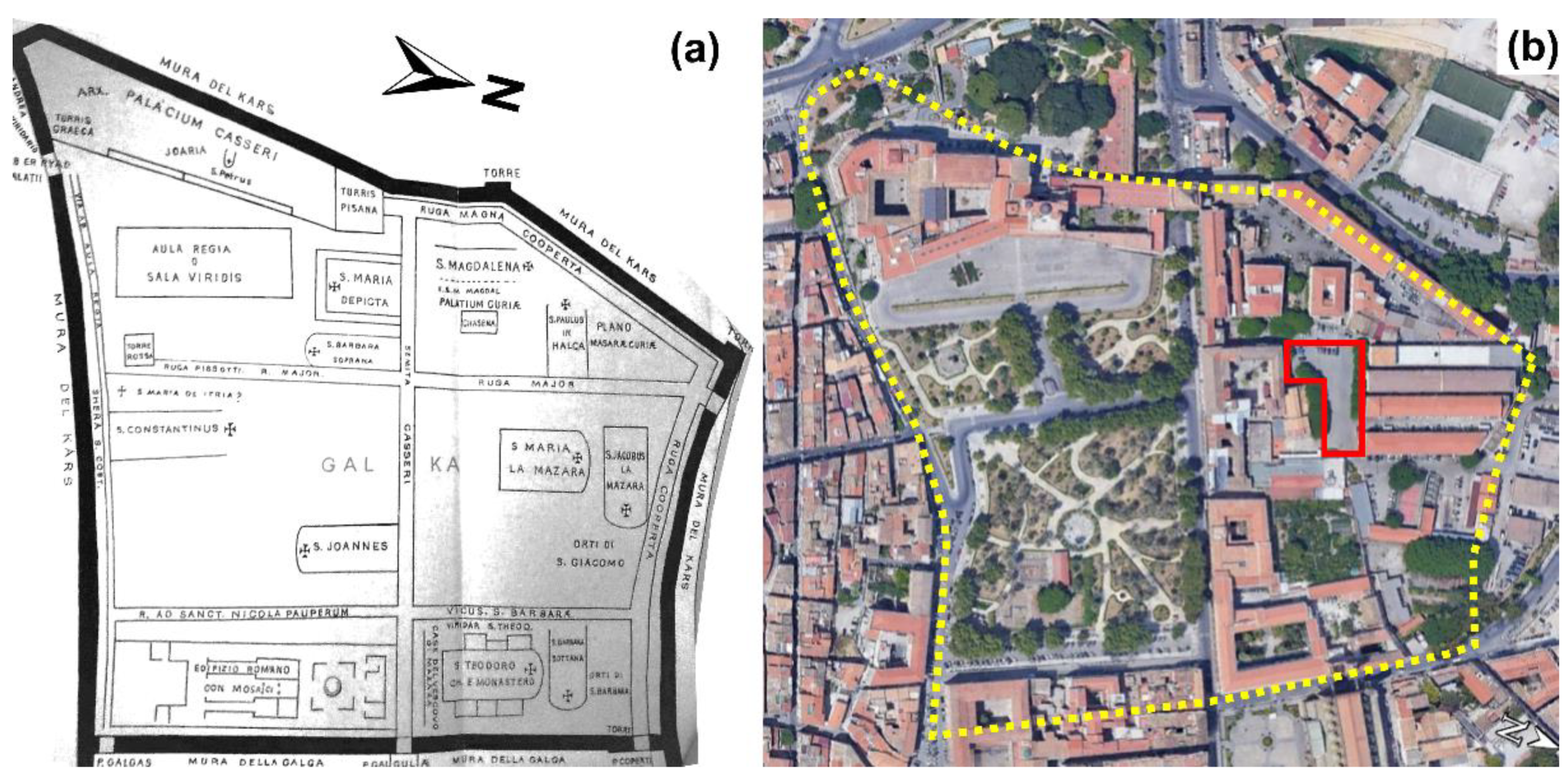
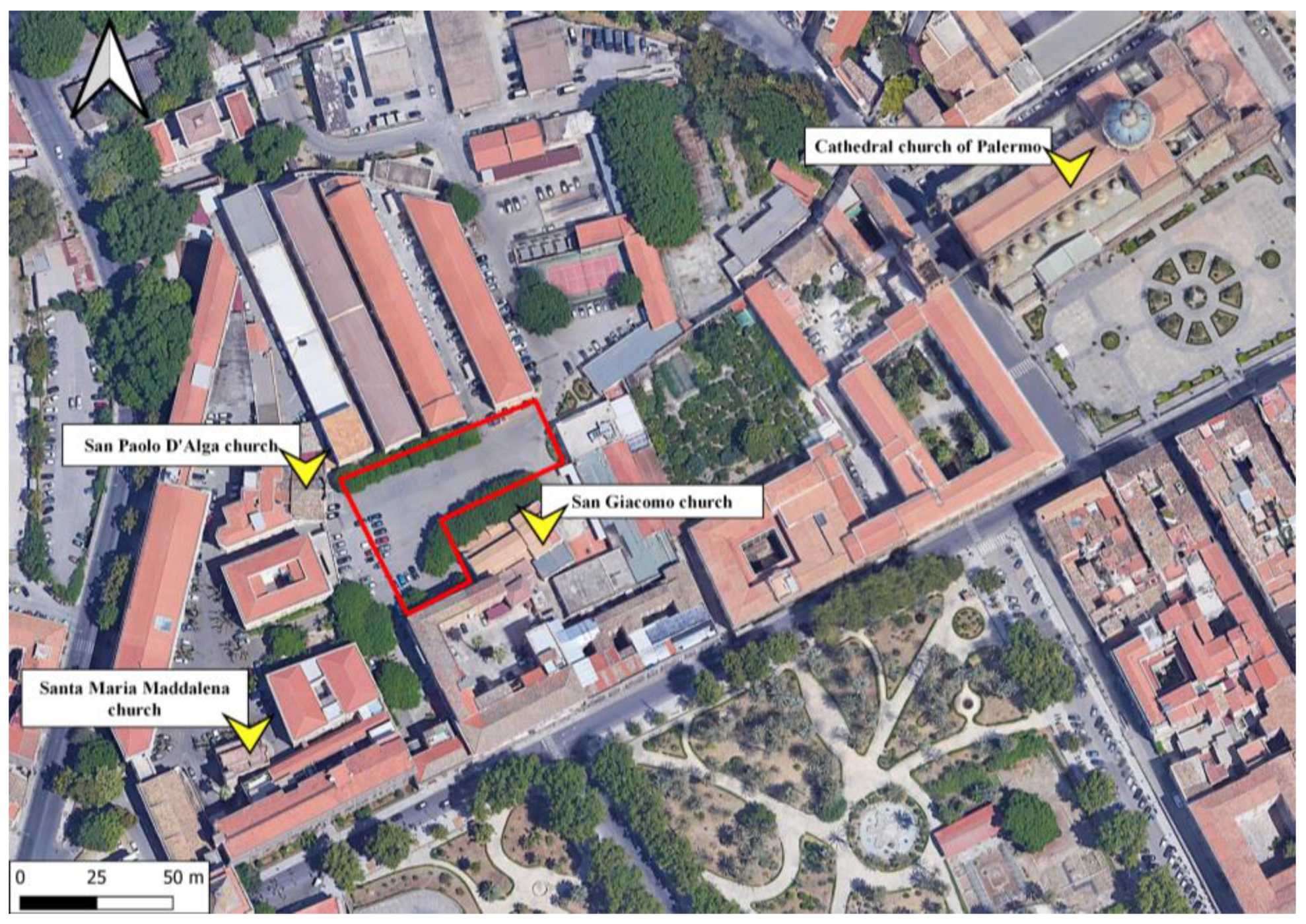
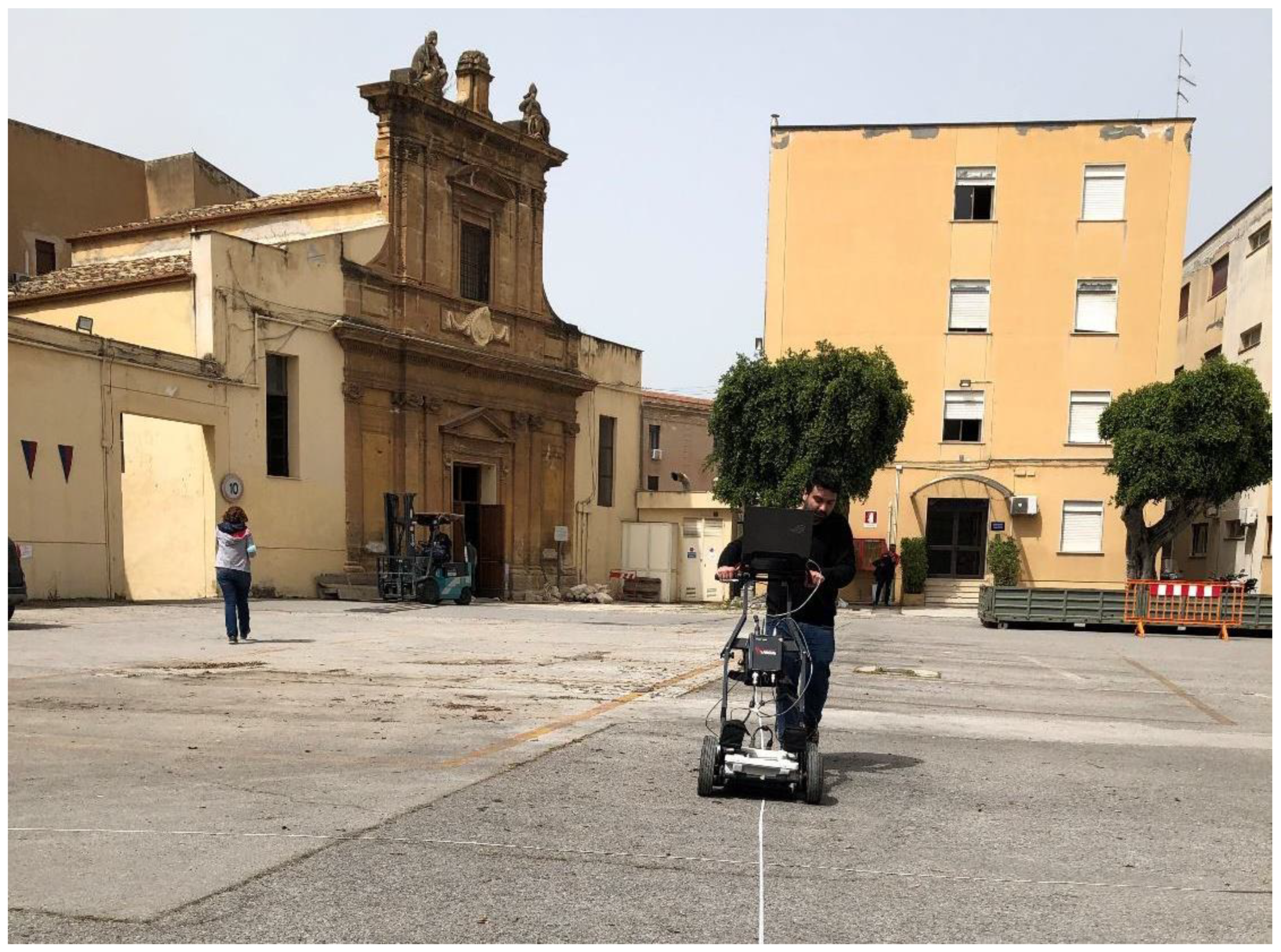
3D GPR Model in the Military District of San Giacomo Degli Spagnoli (Palermo)
 ,
,  ,
,  and
and 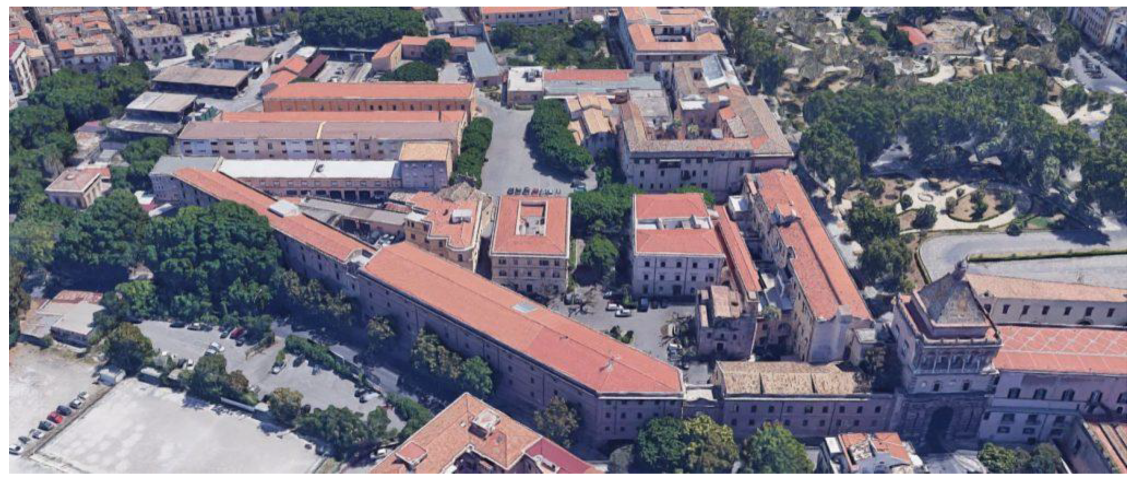
Abstract
:1. Introduction
2. Materials and Methods
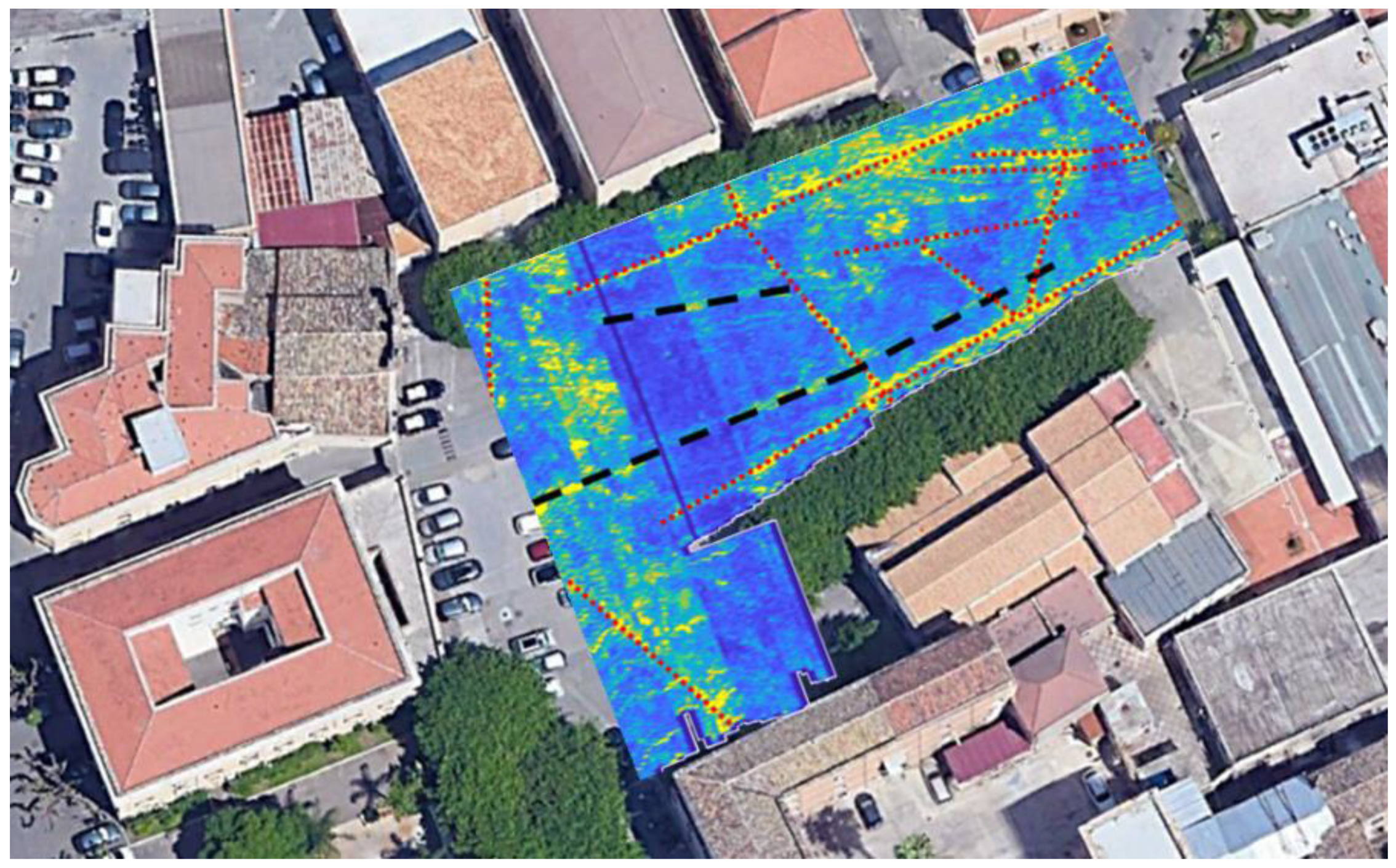
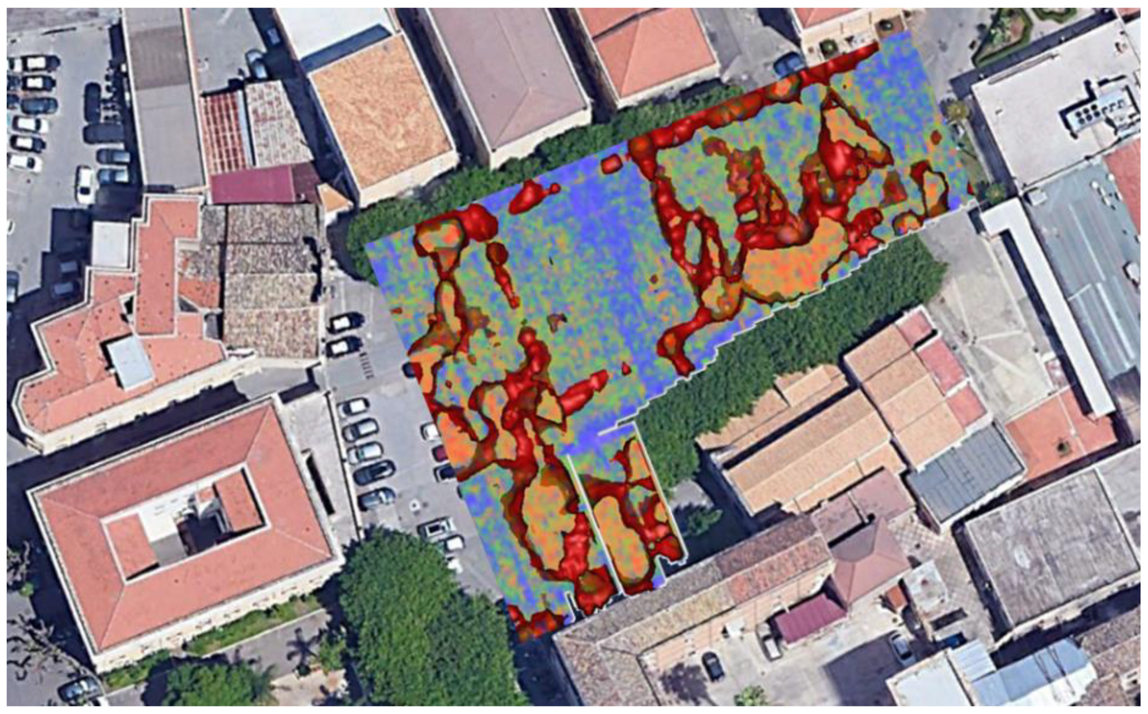
3. Results
4. Conclusions
Author Contributions
Funding
Institutional Review Board Statement
Informed Consent Statement
Data Availability Statement
Acknowledgments
Conflicts of Interest
References
- Palermo, G. Guida Istruttiva per Potersi Conoscere Con Facilità Tanto Dal Siciliano, Che Dal Forestiere Tutte le Magnificenze, e Gli Oggetti Degni di Osservazione della Città di Palermo; Reale Stamperia: Palermo, Italy, 1816; Volume 4. [Google Scholar]
- Bellafiore, G. Edifici di Età Islamica e Normanna Presso la Cattedrale di Palermo; Ministero dei Beni e delle Attività Culturali e del Turismo, Bollettino d’Arte: Rome, Italy, 1967; Volume 52, pp. 178–195. [Google Scholar]
- Di Giovanni, V. La Topografia Antica di Palermo dal Secolo X al XV: Memorie di Vincenzo di Giovanni; Tip. e Legatoria del Boccone del Povero: Palermo, Italy, 1889; Volume 1. [Google Scholar]
- Di Marzo, G. Delle Belle Arti in Sicilia per Gioacchino di Marzo: Dai Normanni Sino Alla Fine del Secolo XIV; Di Marzo, S., Ed.; Biblioteca Nazionale di Palermo: Palermo, Italy, 1858; Volume 1, p. 375. [Google Scholar]
- Serradifalco, D.L.F.P. Del Duomo di Monreale e di Altre Chiese Siculo Normanne Ragionamenti Tre per Domenico Lo Faso Pietrasanta duca di Serradifalco; Roberti, T., Ed.; Palermo, Italy, 1838. [Google Scholar]
- Mortillaro, V. Guida per Palermo e Pei Suoi Dintorni del Barone V. Mortillaro; Letterario, T.d.G., Ed.; Biblioteca Nazionale Centrale di Roma: Rome, Italy, 1836; p. 76. [Google Scholar]
- Inveges, A. Annali della Felice Città di Palermo, Prima Sedia, Corona del re, e Capo del Regno di Sicilia; Dell’Isola, P., Ed.; Palermo, Italy, 1651; Volume 3. [Google Scholar]
- Guiotto, M. La Chiesa di S. Maria Maddalena in Palermo; Ministero dei Beni e delle Attività Culturali e del Turismo, Bollettino d’Arte: Rome, Italy, 1949; Volume 34, pp. 361–367. [Google Scholar]
- Capizzi, P.; Marrone, M.; Nero, C.A.; Bonfardeci, A.; Canzoneri, A.; Carollo, A.; Martorana, R.; Romano, F. Georadar Investigations in the Church of San Paolo (San Giacomo Dei Militari, Palermo). In Proceedings of the NSG2021 2nd Conference on Geophysics for Infrastructure Planning, Monitoring and BIM, European Association of Geoscientists & Engineers, Bordeaux, France, 29 August–2 September 2021; Volume 2021, pp. 1–5. [Google Scholar]
- Ranalli, D.; Scozzafava, M.; Tallini, M. Ground penetrating radar investigations for the restoration of historic buildings: The case study of the Collemaggio Basilica (L’Aquila, Italy). J. Cult. Herit. 2004, 5, 91–99. [Google Scholar] [CrossRef]
- Masini, N.; Persico, R.; Rizzo, E. Some examples of GPR prospecting for monitoring of the monumental heritage. J. Geophys. Eng. 2010, 7, 190–199. [Google Scholar] [CrossRef]
- Pérez-Gracia, V.; Caselles, J.O.; Clapés, J.; Martinez, G.; Osorio, R. Non-destructive analysis in cultural heritage buildings: Evaluating the Mallorca cathedral supporting structures. NDT & E Int. 2013, 59, 40–47. [Google Scholar]
- Binda, L.; Zanzi, L.; Lualdi, M.; Condoleo, P. The use of georadar to assess damage to a masonry Bell Tower in Cremona, Italy. Ndt E Int. 2005, 38, 171–179. [Google Scholar]
- Pieraccini, M.; Mecatti, D.; Luzi, G.; Seracini, M.; Pinelli, G.; Atzeni, C. Non-contact intrawall penetrating radar for heritage survey: The search of the ‘Battle of Anghiari’ by Leonardo da Vinci. NDT E Int. 2005, 38, 151–157. [Google Scholar]
- De Giorgi, L.; Lazzari, M.; Leucci, G.; Persico, R. Geomorphological and non-destructive GPR survey for the conservation of frescos in the rupestrian churches of Matera (Basilicata, southern Italy). Archaeol. Prospect. 2020. [Google Scholar] [CrossRef]
- Capizzi, P.; Martorana, R.; Messina, P.; Cosentino, P.L. Geophysical and geotechnical investigations to support the restoration project of the Roman ‘Villa del Casale’, Piazza Armerina, Sicily, Italy. Near Surf. Geophys. 2012, 10, 145–160. [Google Scholar] [CrossRef]
- Martorana, R.; Capizzi, P. Joint investigation with Ground Penetrating Radar and Infrared Thermography as a Diagnostic Support for the Restoration of Two Wall Mosaics in the Church of St. Mary of the Admiral in Palermo, Italy. Heritage 2022, 5, 2298–2314. [Google Scholar] [CrossRef]
- Casas, A.; Cosentino, P.L.; Fiandaca, G.; Himi, M.; Macías, J.M.; Martorana, R.; Muñoz, A.; Rivero, L.; Sala, R.; Teixell, I. Non-invasive geophysical surveys in search of the Roman Temple of Augustus under the Cathedral of Tarragona (Catalonia, Spain): A Case Study. Surv. Geophys. 2018, 39, 1107–1124. [Google Scholar] [CrossRef] [Green Version]
- Martorana, R.; Capizzi, P. Seismic and non-invasive geophysical surveys for the renovation project of Branciforte Palace in Palermo. Archaeol. Prospect. 2020, 1–14. [Google Scholar] [CrossRef]
- Cozzolino, M.; Di Giovanni, E.; Gentile, V.; Mauriello, P.; Pizzano, N. Ground-Penetrating Radar Survey for the Study of the Church of Saint Cosma in Helerito (Tagliacozzo, L’Aquila, Italy). Geosciences 2020, 10, 244. [Google Scholar] [CrossRef]
- Bottari, C.; Capizzi, P.; Martorana, R.; Azzaro, R.; Branca, S.; Civico, R.; Fucile, M.; Pecora, E. Diagnostic Multidisciplinary Investigations for Cultural Heritage at Etna Volcano: A Case Study from the 1669 Eruption in the Mother Church at the Old Settlement of Misterbianco. Remote Sens. 2022, 14, 2388. [Google Scholar] [CrossRef]
- Cozzolino, M.; Gentile, V.; Giordano, C.; Mauriello, P. Imaging Buried Archaeological Features through Ground Penetrating Radar: The Case of the Ancient Saepinum (Campobasso, Italy). Geosciences 2020, 10, 225. [Google Scholar] [CrossRef]
- Basile, V.; Carrozzo, M.T.; Negri, S.; Nuzzo, L.; Quarta, T.; Villani, A.V. A ground-penetrating radar survey for archaeological investigations in an urban area (Lecce, Italy). J. Appl. Geophys. 2000, 44, 15–32. [Google Scholar] [CrossRef]
- Chìas, P.; Abad, T.; Echeverríaa, E. Terrestrial and Aerial Ground-penetrating Radar in use for the Architectural Researches: Ancient 16th Century Water Supply and Drainage at the Monastery of El Escorial (Madrid, Spain). Remote Sens. Spat. Inf. Sci. 2013, 5, W2. [Google Scholar] [CrossRef] [Green Version]
- Berezowski, V.; Mallett, X.; Ellis, J.; Moffat, I. Using Ground Penetrating Radar and Resistivity Methods to Locate Unmarked Graves: A Review. Remote Sens. 2021, 13, 2880. [Google Scholar] [CrossRef]
- Bellanova, J.; Calamita, G.; Catapano, I.; Ciucci, A.; Cornacchia, C.; Gennarelli, G.; Giocoli, A.; Fisangher, F.; Ludeno, G.; Morelli, G.; et al. GPR and ERT Investigations in Urban Areas: The Case-Study of Matera (Southern Italy). Remote Sens. 2020, 12, 1879. [Google Scholar] [CrossRef]
- Baker, G.S.; Jordan, T.E.; Pardy, J. An introduction to ground penetrating radar (GPR). Special Papers. Geol. Soc. Am. 2007, 432, 1. [Google Scholar]
- Cozzolino, M.; Di Giovanni, E.; Mauriello, P.; Piro, S.; Zamuner, D. Geophysical Methods for Cultural Heritage Management; Springer International Publishing: Cham, Switzerland, 2018. [Google Scholar]
- Sandmeier, K.J. ReflexW, version 8.1. Program for Processing of Seismic, Acoustic or Electromagnetic Reflection, Refraction and Transmission Data. Software Manual. Karlsruhe, Germany, 2016.
- Tillard, S.; Dubois, J.C. Analysis of GPR data: Wave propagation velocity determination. J. Appl. Geophys. 1995, 33, 77–91. [Google Scholar] [CrossRef]
- Fazello, T. De Rebus Siculis Decades Duae, Nunc Primum in Lucem Editae. His Accessit Totius Operis Index Locupletissimus; Mayda, I.M., Carrara, F., Eds.; Palermo, Italy, 1558. [Google Scholar]
- Shepard, D. A two-dimensional interpolation function for irregularly-spaced data. In Proceedings of the 23rd National Conference ACM, New York, NY, USA, 27–29 August 1968; ACM: New York, NY, USA, 1968; pp. 517–524. [Google Scholar]


Disclaimer/Publisher’s Note: The statements, opinions and data contained in all publications are solely those of the individual author(s) and contributor(s) and not of MDPI and/or the editor(s). MDPI and/or the editor(s) disclaim responsibility for any injury to people or property resulting from any ideas, methods, instructions or products referred to in the content. |
© 2023 by the authors. Licensee MDPI, Basel, Switzerland. This article is an open access article distributed under the terms and conditions of the Creative Commons Attribution (CC BY) license (https://creativecommons.org/licenses/by/4.0/).
Share and Cite
Capizzi, P.; Martorana, R.; Canzoneri, A.; Carollo, A.; Majani, M.V. 3D GPR Model in the Military District of San Giacomo Degli Spagnoli (Palermo). Heritage 2023, 6, 2601-2613. https://doi.org/10.3390/heritage6030137
Capizzi P, Martorana R, Canzoneri A, Carollo A, Majani MV. 3D GPR Model in the Military District of San Giacomo Degli Spagnoli (Palermo). Heritage. 2023; 6(3):2601-2613. https://doi.org/10.3390/heritage6030137
Chicago/Turabian StyleCapizzi, Patrizia, Raffaele Martorana, Alessandro Canzoneri, Alessandra Carollo, and Marco V. Majani. 2023. "3D GPR Model in the Military District of San Giacomo Degli Spagnoli (Palermo)" Heritage 6, no. 3: 2601-2613. https://doi.org/10.3390/heritage6030137