Article

Geomagnetic and FDEM Methods in the Roman Archaeological Site of Bocca Delle Menate (Comacchio, Italy)

1
Dipartimento di Fisica e Scienze Della Terra, University of Ferrara, 44121 Ferrara, Italy
2
Consiglio Nazionale delle Ricerche—Istituto di Metodologie Per l’Analisi Ambentale (CNR-IMAA), 85050 Zona Industriale, Italy
3
Dipartimento di Studi Umanistici, University of Ferrara, 44121 Ferrara, Italy
*
Author to whom correspondence should be addressed.
Heritage 2023, 6(2), 1698-1712; https://doi.org/10.3390/heritage6020090
Submission received: 26 December 2022 / Revised: 31 January 2023 / Accepted: 1 February 2023 / Published: 5 February 2023
(This article belongs to the Special Issue Geophysical Surveys for Heritage and Archaeology)

Abstract

:
The increasing use of geophysical investigations for archaeological purposes is now provided also by Italian reforms about preventive archaeology. They allow not only the discovery or the spatial definition of possible buried archaeological evidence, but they are also able to define the state of preservation of ancient structures. The Bocca delle Menate archaeological site is in Comacchio village territory, situated in Ferrara provence (Emilia Romagna region, Italy). The archeological site provides important evidence of the Roman presence in the Po Delta (Italy). The Roman villa was excavated between 1958 and 1959, during the reclaiming works in the Mezzano Valley (Comacchio, Ferrara). An archaeological preliminary survey and a geophysical field trip using Geomagnetic and Frequency Domain Electromagnetic Methods were carried out, following the aim to identify the planimetry of the villa previously excavated and eventually newly discovered archaeological remains. The geomagnetic results detected the archaeological buried structures, even if the original disposition of them is not completely highlighted. The electromagnetic method was able to depict the geological and geomorphological background surrounding the Roman villa. The obtained results highlighted that the applied geophysical methods are excellent tools for the preservation, protection, and monitoring of archaeological heritage previously excavated, adding to their already known importance as best tools for new archaeological buried remains detections.

1. Introduction

The application of geophysical methodologies in the archaeological field represents an essential phase for the detection of the archaeological buried structures, during the preliminary phases of the archaeological activities, as well as for those archaeological sites excavated in the past for which it has not been possible to develop conservation projects.
The geophysical techniques are useful for the detection of archaeological buried remains, and the archaeologists are grateful to them for the help in detect them and for pointing out where they should dig. Usually, after this phase, the findings are mapped and re-buried when a conservation project is not developed. In the past, several buried archaeological structures were detected during the excavation phase for construction work (roads, canals, etc.), and the detected remains were highlighted and sketched on a work paper and later buried again. When an indirect survey was not available, several archaeological structures continued to be buried around the excavated area. Therefore, the geophysical methodologies are so crucial for those old archaeological sites, which were excavated decades ago, both to highlight them again and to detect new buried remains. A great variety of geophysical methods are currently available for specific archaeological demands, and the techniques that are most useful in this field are: geomagnetic (MAG) investigation, ground penetrating radar (GPR), electrical resistivity (ER), and electromagnetic (EM) acquisitions [1,2,3,4,5,6,7,8,9,10]. The geomagnetic technique is a passive method and, therefore, it is based on measurements of the Earth’s magnetic field with sensitivity on the order of nanoTeslas (nTs). The geomagnetic method can detect archaeological remains by analysing the variations of the Earth’s magnetic field due to the different magnetic susceptibilities of construction materials and the magnetic characteristics of the shallow subsoil. GPR is based on the introduction of electromagnetic waves in the medium and the subsequent recording of the reflections suffered by the signal imputable to the electromagnetic impedance variations. The method uses a fundamental relationship that links the velocity of propagation of the EM waves with the dielectric permittivity of the medium. The ER method works by injecting current into a pair of current electrodes, and the potential difference is measured between a pair of potential electrodes. The combination between these two parameters (Ohm’s law) aims to determine the subsoil spatial electrical resistivity distribution. Electromagnetic induction methods allow the acquisition of in-phase and out of phase (or quadrature) components, which can be related to the electrical conductivity and magnetic susceptibility of the subsurface. The use of geophysical methods is suggested in all cases where information is needed on subsurface features before the excavation. These methods provide excellent resolution of many types of archaeological features, and they are capable of high sample density surveys of very large areas and of operating under a wide range of conditions. Moreover, the use of different methods is good practice in most geophysical survey applications because each geophysical method responds to different properties, and multiple data sets are complementary, rather than redundant. Even if the geophysical instruments are expensive, the cost of geophysical survey is very often offset by a reduction in the expense of exploratory excavation. On the contrary, the application of geophysical methods is often limited by ambiguity of the physical parameter in relation to the interpretation of results.
In most cases, MAG and GPR yield the best results due to the significance of the corresponding geophysical parameters and the high resolution of the advanced equipment available today. These methods are able to investigate, at different resolutions, the buried structures in the first meters of the subsoil, and there are several papers that reported their success [1,2,3,4,5,6,7,8,9,10]. On the contrary, even if the EM and geoelectrical (DC) methods are applied to detect buried structures, they are most useful to define the geological and geomorphological surrounding context [6,7,10,11,12]. Geomagnetometry and GPR offer a fast and cheaper way to survey the archaeological sites, thanks to the possibility to investigate large areas [13,14,15]. Each geophysical method highlights well the anomalies due to buried archaeological structures, but only an integration of different methods is useful to define the detailed geometry and the depth of them.
The studied archaeological site is located in Bocca delle Menate area, and it is located in Emilia Romagna region, close the Comacchio (FE) town. The archaeological site was studied following two main directions: archaeological and geophysical steps. The geophysical steps consisted of the use of a MAG walk survey and Frequency Domain Electromagnetic (FDEM) quad bike dragged investigation. The aim was to depict the main buried remains and to define the location of the archaeological structures previously excavated in the 1950s (Figure 1). Geophysical and archaeological investigations were conducted at the site of Bocca delle Menate in collaboration with the municipality of Comacchio, framed within the project VALUE (Environmental and Cultural Heritage Development), and it was carried out after the non-invasive research authorization by the ABAP Superintendency of Bologna [16].
With this in mind, the new investigations aim to answer several questions that have remained open, such as knowing the positioning and state of preservation of the structures found during the excavation in the 1950s and understanding the planimetric articulation of the facility and the development of the complex beyond the area already investigated, also in relation to the ancient landscape.

2. Materials and Methods

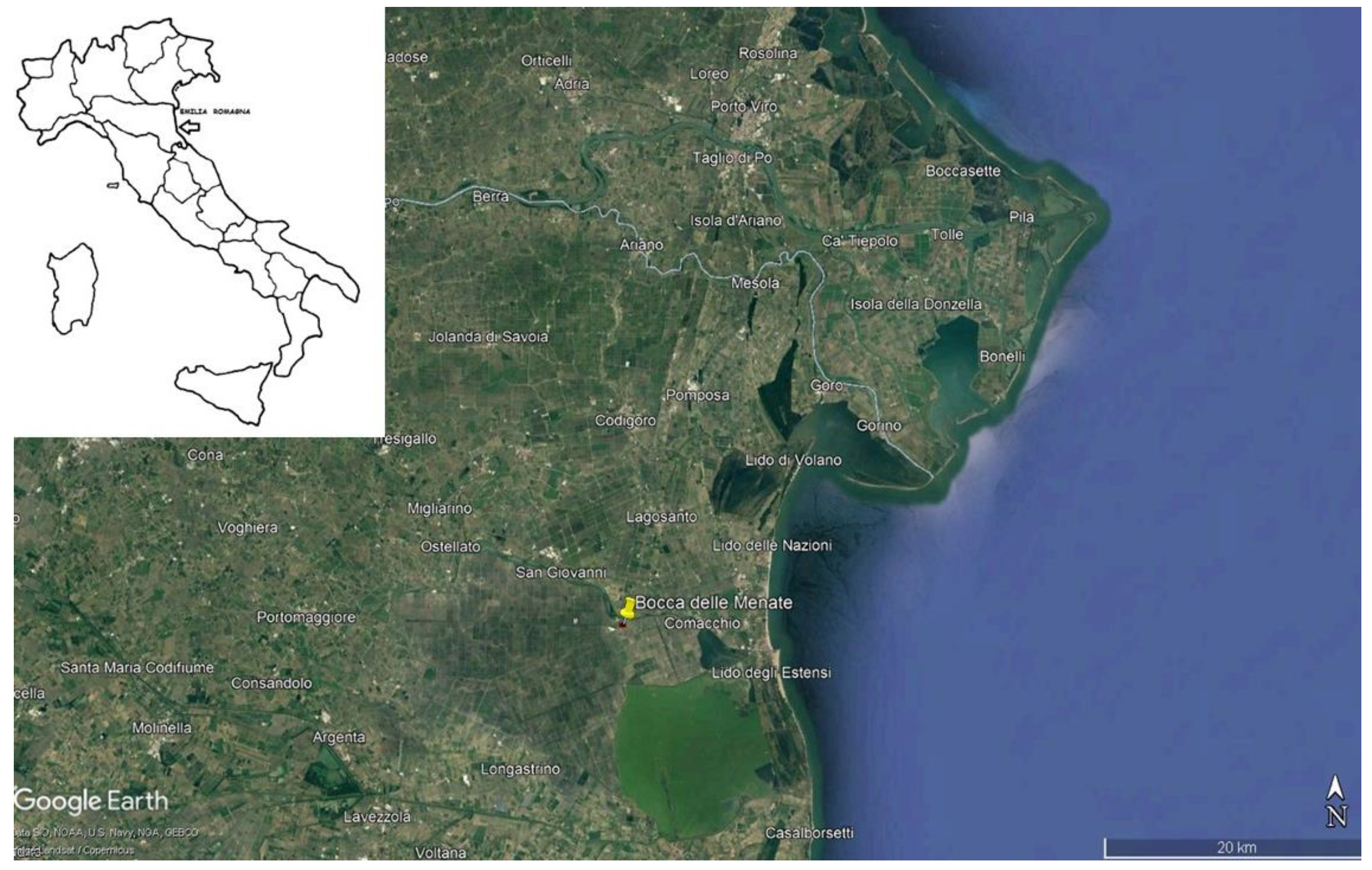
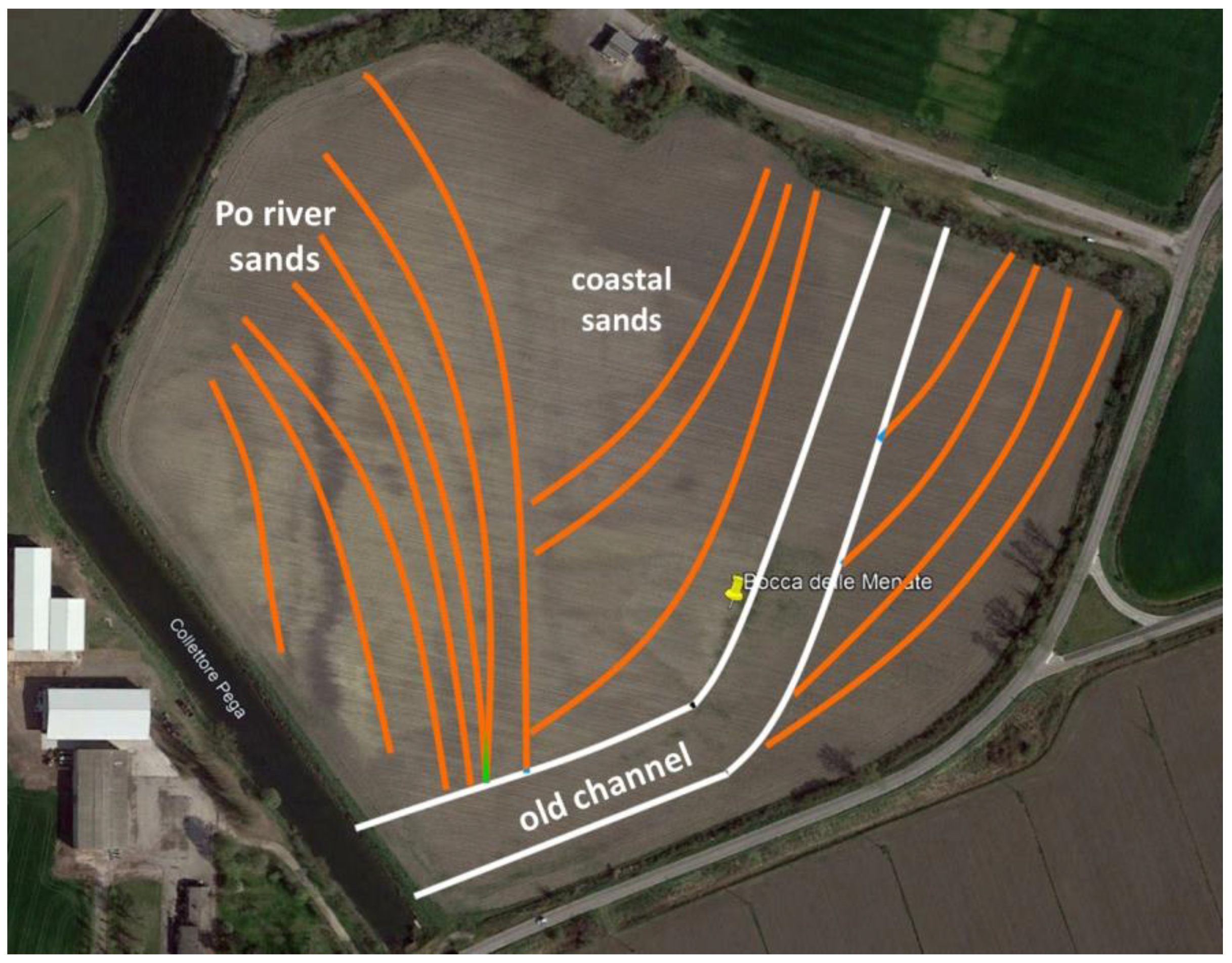
2.1. Geological and Geomorphological Setting

The anthropic settlement of the Bocca delle Menate area was strongly influenced by the geological, geomorphological, and hydraulic framework of the Po Delta region. The investigated area defines the Padana-Apennine Trench transition, which represents the continuity between the Apennine chain and the Alpine chain. The area is characterized by a large quaternary sedimentation of transition between continental and marine environment accumulated in the Early to Middle Pleistocene age and in the Middle Pleistocene–Holocene age [17]. The stratigraphic architecture of the Po Delta plain was controlled by eustatic and climatic fluctuations. The stratigraphic architecture of Late Quaternary deposits was strongly controlled by glacio–eustatic fluctuations and a regular alternation of alluvial plain deposits, related to major sea level falls, with coastal/shallow marine sediments, which accumulated during subsequent episodes of sea level rise [18]. The events after the glaciation period delineated the actual geological setting.
The Roman villa of Bocca delle Menate stood on littoral cord sands, near their contact, with more recent fluvial deposits of Po River (Figure 2). The Po (or Padus in Latin) valley has always been characterized as a lagoon landscape with numerous waterways and extensive area covered by rich and varied vegetation. The valley has undergone continuous evolutions and changes [19]. Clayey soils are the prevalent geology in the central area of Comacchio, where depressions and paleorivers are distributed.
The alternating phases of emersions and flooding of the territory defines the complex evolutionary history [19]. The lithology of the surface and in the subsoil of the investigated area shows the alternation and interdigitation of continental lithologies (paleorivers, dune cordons) with marine lithologies (sands, silts, clays). The lithology of the dune cordons is predominantly sandy, but, on the contrary, the paleorivers are affected by a clay lithology. However, the ancient perifluvial route, close the Roman villa site, was elevated, and it provided a useful connection with the important consular routes near Via Popillia, which linked the Po Valley and the sea. This important route crossed the Po river, three kilometers downstream from Bocca delle Menate, developing along the aeolian dunes [20].

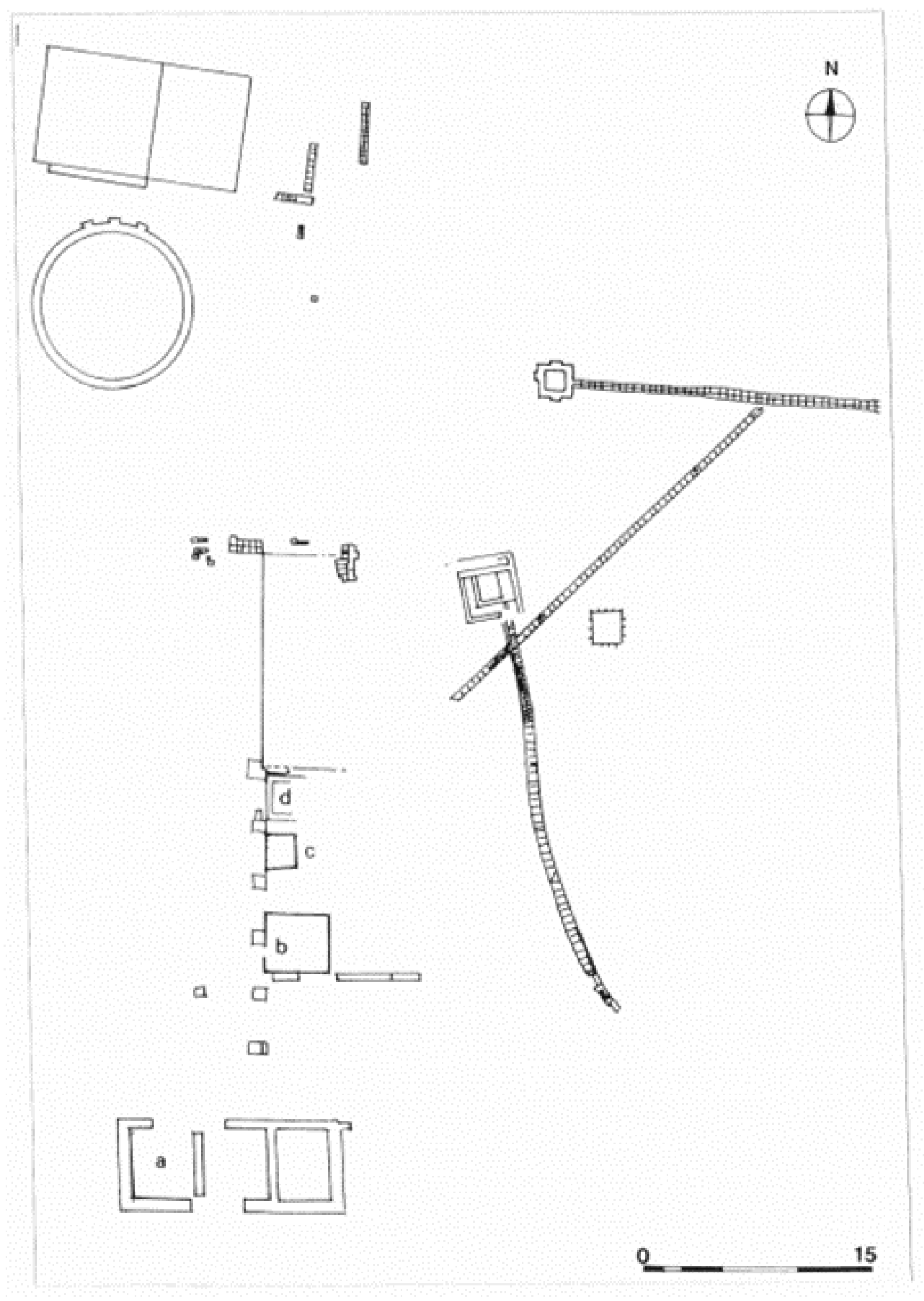
2.2. Archaeological Contexts

In the studied archaeological site, the Roman villa (Bocca delle Menate) has been intercepted in 1958 during the realization of a canal as a temporary water-scooping machine in Lepri Valley, which was built for the reclamation of the Mezzano Valley. In that period, the Roman villa was partially excavated in 1959 by Nereo Alfieri [21]. The Bocca delle Menate complex thus falls within the Po Delta area, whose ancient landscape, covered with rich and varied vegetation, was dominated by riverbeds and river mouths, littoral cords, and beaches alternating with valley areas distributed on the paralittoral fringe and was characterized by widespread phenomena of hydrographic instability related to the activation of new river branches in a sector that, from the paleoenvironmental point of view, was deeply involved by the evolution of the Po Delta between the Bronze Age (Po of Adria) and the Roman period (Po di Volano). In Roman times, and especially between the 1st century BC and the 3rd century AD, connections between cities and smaller towns and navigation in the delta area were guaranteed both by the presence of natural waterways (river and lagoon routes) and by the creation of artificial canals, the fossae, particularly the fossa Augusta, an engineering work commissioned by Augustus to connect Ravenna to the Po Delta [22]. An important role for the connections was also played by the overland routes, as is represented by the via Popillia, opened in 132 BC to connect Bologna to Rimini, regarding which a second section was then built from Rimini to Altino-Aquileia, passing through Ravenna and Adria (128 BC). Land and water routes were also fundamental trade routes that connected the Mediterranean to the Cisalpine area: in their vicinity, numerous settlements developed, devoted to the exploitation of local resources and the production of clay for the manufacture of building materials (roof tiles, roofing tiles, bricks, etc.). Taking into account settlement typology, the archaeological remains allow us to suppose that starting from the late Republican age, and the Po Delta area was occupied by a scattered type of settlement: small centers on the river bumps and the vici—such as vicus Habentia (Voghenza village) and vicus Varianus (Vigarano Mainarda village). Close to them, some villae, such as villa of Bocca delle Menate, are present, consisting of a residential part and a productive part formed by buildings functional to the works of exploitation of the territory [23]. These villas, located along the most important routes of communication, were linked to land of vast dimensions, the latifundia or saltus, initially belonging to members of the Roman ruling class, then merged, through confiscation or sale, in the imperial patrimony.
The great works of land reclamation that have affected the Valleys of Comacchio since the 1920s have highlighted not only the remains of the famous Graeco-Etruscan settlement of Spina, but also what remained of these villas. The Roman villa of Bocca delle Menate was located on the eastern bank of the Po River, on an area of about 1000 mq (Figure 3) and in a position of large economic interest and neuralgic importance in the sphere of the navigation routes, close to Spina town and in proximity to the junction of the fossa Augusta in the Po River and the via Popillia. Nereo Alfieri’s excavations in 1959 allowed to know the presence of a pars dominica, with refined living rooms and spaces devoted to productive activities. On the contrary, even if an approximate planimetric sketch of the villa was made (Figure 3), the excavated structures were not defined on a georeferenced map. Moreover, to identify the highlighted structure plan of the site, and to consequently give detailed information about their conservation, a geophysical work approach was required by geomagnetic and electromagnetic analyses in the site.

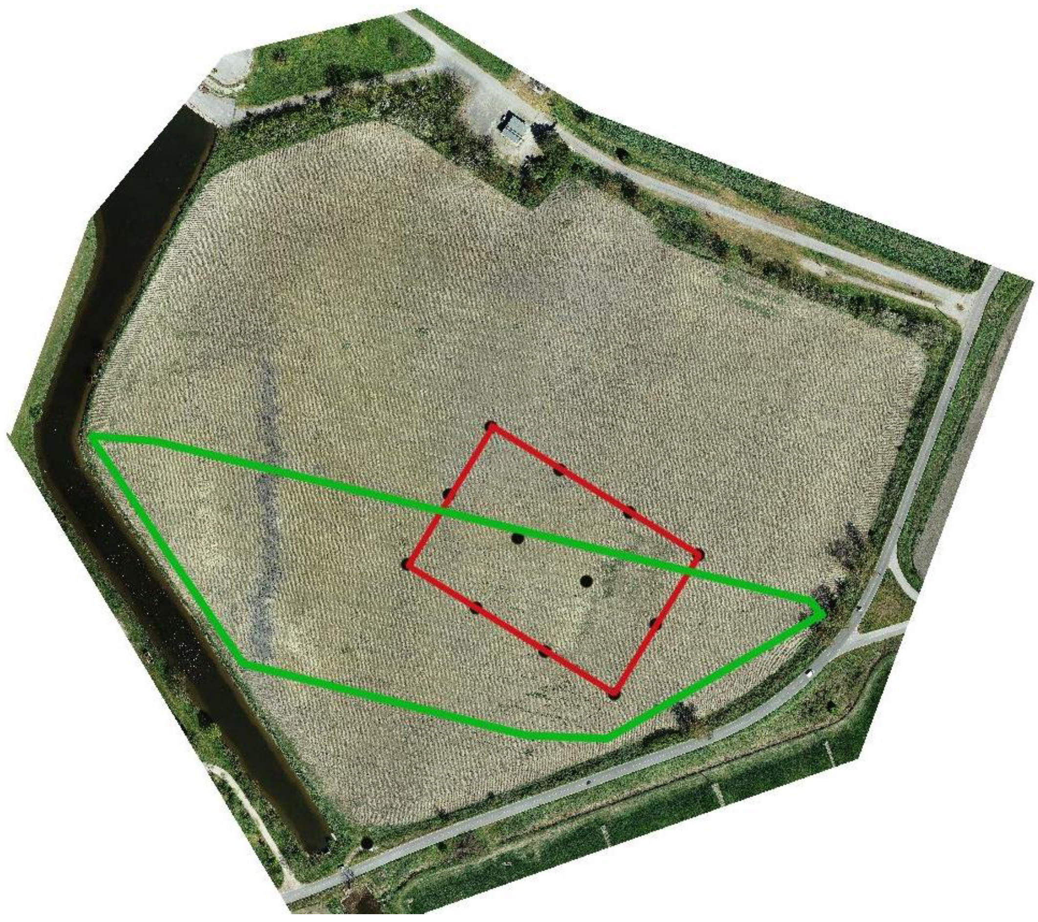
2.3. Preliminary Study

The methodologies adopted for carrying out the survey are those of ancient topography, with careful analysis and reading of cartography, both historical and modern, archival records and aerial photos [24]. In the preliminary study of the site, in fact, bibliographic research was supplemented with analysis of historical cartography, essential for understanding the evolution of the landscape in relation to the location of the villa. Archival research documented the site’s transformations across time: from excavation journals we learned about the systematic disassembly of some archaeological structures of the Roman villa (the three canals and a pit kiln in the eastern excavated area), compromised of the backhoe during the construction of the drainage pump canal in 1959. The archival documentation also informed us about some anthropic actions correlated with the farming activities, such as the regularization of the land surface with two farm tractors in June 1974 and various interventions of soil removal, leveling, and excavation in 1987/1989/1995, which damaged the archaeological layers, not taking into account the constraints to which the area was subjected [20].
QG is a geodatabase, collecting information from different research fields, which was created in order to obtain an overall view of the current articulation of the area, to better plan the surveys analysis, and, finally, to systematize new territorial information to be acquired [20].

2.4. The Field Work

In the frame of the on-field activity, an orthophoto of the area has been realized from photogrammetric elaboration of drone captures. This cartographic base was functional for the documentation and georeferencing of the archaeological and geophysical surveys aimed at both the analysis of the extent of the Roman villa within the investigated plot of land and a deeper understanding of the type of buried structures and their state of preservation. The intensive field survey revealed a series of interesting information and patterns, starting from the placement of the finds to the type of the numerous materials collected, brought back to the surface by recent ploughing activities and currently being studied [26]. The purpose of the geophysical investigations aims to answer some questions related to the knowledge of the state of preservation of the structures and their presence or absence and the location of the findings made in the 1950s, including the planimetric articulation of the area already investigated. Geophysical methodologies are indeed of great help in the archaeological field, making it possible to locate finds in even large areas, relatively quickly and with high accuracy, at least in the first few meters of subsurface. This allows archaeologists to limit excavation at identified anomalies.
The most commonly and reliably used method in archaeological geophysics is geomagnetic. By means of geomagnetic approach, it is possible to investigate large subsurface areas in a relatively short time and to identify the most significant archaeological anomalies [4]. At this stage, a detailed geomagnetic survey conducted by foot and a large electromagnetic investigation conducted by quad were carried out in the archaeological area (Figure 4).

2.5. Geomagnetic Investigation

The geomagnetic survey was carried out in the archaeological area using the Overhauser GSM-19 (GEM System) in walk gradiometric setting. The Overhauser instrument has two magnetic probes located on the operator’s backpack (Figure 5). The two magnetic sensors are locked at a mutual distance of about 1 m, and the distance between the bottom magnetic sensor and the topsoil was about 20 cm. The adopted gradiometric configuration allowed the automatic removal of the diurnal variations of the natural magnetic field. The geomagnetic diurnal variation is known as magnetic daily variation, and it is the oscillation of the earth’s magnetic field, which has a periodicity of about a day. If a single sensor is used, a second sensor must be kept in a stationary position to record diurnal variation in the Earth’s magnetic field. Daily variation is removed by subtracting it from the roving magnetometer measurements. When a gradiometric instrument is moved together across a site, the magnetic field gradient is directly obtained. This is important because if the magnetic field strength will change during the day, the gradient measure will be the same. The geomagnetic survey was carried along parallel profiles 1 m apart with a sampling rate of 5 Hz. This grid setting permitted us to obtain a mean spatial resolution of 1.0 m × 0.125 m. The data were collected with GPS coordinates.
The investigated area is about 15.000 mq, according to the acquisition grid shown in Figure 6. The disposition of the gradiometric survey was defined in according with the archaeologists after the identification of the potential area where the previous archaeological excavations were located. This process was defined on the analysis of old aerial photos, the historical Google Earth images, and a new UAV image (Figure 4). After the image work process, the geomagnetic survey was gridded on the selected area, which was divided into six parts. Each one is 2500 mq, with a dimension around 50 m × 50 m (Figure 6).
The geomagnetic survey was acquired in zig-zag mode, according to parallel profiles spaced one meter apart. The walking speed was assumed to be equal to 1 ms−1 in order to have a high data resolution along each line (sample frequency of 5 Hz). Further, all the acquisitions are supported by a topographical survey, allowing a centimetre accuracy for the geophysical acquisition. Indeed, all the geomagnetic acquisitions have been preceded by the tracking of regular polygons within which the measurements are carried out. The preliminary elaboration phase of the acquired data consisted of using GemLink software to remove the outliers imputable to the operator walking. Then, the 70.000 data were elaborated with the TerraSurveyor software [27]. In detail, the work flow of the geomagnetic elaboration consisted in filtering the raw data to increase the signal/noise ratio [28]. The first elaboration step provided a clip process to remove extreme datapoint value. The second step was defined by the despike filter, which consisted of removing spikes caused by small surface iron anomalies. Moreover, each data set was processed with a destagger filter in order to compensate for data collection errors caused by the operator, which started recording each line too soon or too late. Finally, a destripe process was applied in order to equalize underlying differences between grids and to reduce the linear features. All the filtered data in TerraSurveyor software were transferred into the Surfer software, which is a powerful contouring, gridding, and surface mapping package (Surfer 13.0 of Golden Software). The filtered dataset was previously interpolated with a regular grid mapped using the Kriging process with a linear variogram [29]. The last step of the processing workflow defines the image map tool. The image map process defined the final image using specific colormaps able to highlight the main magnetic anomalies.

2.6. Electromagnetic Investigation

The electromagnetic survey was carried out in the archaeological area using the Profiler AMP-400 (GSSI company) (Figure 7). The system acquires the soil electrical conductivity, which is affected by the water content in soil, as well as water-soluble salt content, soil texture, coarse elements, temperature, clay content, mineralogy, cation exchange capacity, organic matter content, and bulk density [30,31,32]. It is able to simultaneously measure up to three frequencies between 1 kHz and 15 kHz, with an inter-coil spacing of 1.2 m. To gain information regarding the subsoil layers, whose frequencies were at 2, 9, and 15 kHz, were used, and instruments were set in vertical dipole mode (VDP), and the sample rate was 0.5 s. The penetration depth of any EM method is dependent upon a variety of subsurface physical properties, as well as the frequency of the inducing magnetic field produced by the Tx. The effect of these properties can be quantified using a proxy value known as the skin depth, δ, which represents the depth in the subsurface at which the field strength has decayed to 1/e (37%) of the surface value [33]:
Δ = 1/√πμσf
where σ is the electrical conductivity, μ is the magnetic permeability, and f is the used frequency of the instrument. In most geological situations, the magnetic permeability μ can be assumed to be equal to the magnetic permeability of free space, μ0 = 4π × *10−7 H/m.
The frequency–domain EM method creates a primary electromagnetic field, which induces eddy currents in the subsurface material. These, in turn, induce a secondary electromagnetic field, which modifies the total field. The difference between these two fields is a function of the subsurface conductivity [34]. Through the assumption of a low induction number (LIN), the quadrature components (or out of phase) are used to obtain a qualitative subsurface conductivity mapping [35]:
σ = (360 × *PPM(Q))/f
σ is the electrical conductivity (S/m), PPM(Q) is the quadrature phase (or out of phase) reading, and f is the frequency in Hz. The measurements were acquired by quad bike along the parallel inter-row of about 5 m at a speed of about 10 km h−1 (Figure 7). The electrical conductivity data were elaborated, deleting the spikes and plotting them with a kriging interpolation tool of the Surfer software (Golden Software). The in-phase components, which can be related to the magnetic susceptibility of the subsurface, are not shown because no correlation with geomagnetic data has been identified.

3. Results

Figure 8 shows the results of the elaborated gradiometric MAG data with a kriging interpolation grid map. The obtained map highlights several anomalies with different shapes and dispositions. The gradiometric values are ranged between +40 nT/m and −45 nT/m, and several anomalies are well detected. The first group of anomalies is located on the western part, where three long parallel gradiometric anomalies are well delineated (L1, L2 and L3 on Figure 8). These linear anomalies have a direction, W-E, and a length, from 50 m to 80 m. One of the main peculiar characteristics is the constant inter-distance between each of them, with a value of about 20 m.
Moreover, the three linear anomalies L1, L2, and L3 are truncated to the east, where they are well delineated with regard to the limit of the previous excavation (dashed line on Figure 9). These anomalies are well compared with the new Google Maps image of the investigated area, where crop marks are well superimposed with gradiometric anomalies (white arrows on Figure 9). These phenomena are well detected only when there are specific conditions of several factors (water content, sediments, mineralogy, vegetation, sun position, etc.), and the small changes can be seen as marked differences in color in the context of the normally surrounding vegetation and soil on the image map.
A second group of gradiometric anomalies are located on the east and middle of the gradiometric map where some regular shapes of them are well detected (Figure 8). The gradiometric anomalies have irregular shapes, but the gradiometric intensity is comparable with the presence of archaeological buried remains.
Even if the gradiometric map highlights three main anomalies (A1, S1, and C1 in Figure 8) that could be associated with buried archaeological objects, the sketch drawn during the previous excavation and shown in Figure 3 is not clearly identified on the geomagnetic image. Only the circular anomaly (C1 in Figure 8) in the central part of the magnetic map with a diameter of about 8–10 m could have some similarity with the large circular structure located on the northwestern part of the archaeological plant (Figure 3). The reasons could be different, for example, the structures identified do not have the conditions to be identified by the method used for an absence of materials capable of producing changes in the local magnetic field, or the area investigated does not completely cover the area of previous excavation.
Subsequently, after geomagnetic prospection, Frequency Domain Electromagnetic (FDEM) measurements were also carried out through a purpose-built drag system. Such investigations allow us to obtain both in-phase and electrical conductivity component data. The Figure 10 shows the electrical conductivity calculated from the out of phase component (Quadrature, Q). This component is more sensitive to the electrical characteristics of the materials in the subsurface and, therefore, comparable with the different geological lithologies in the area.
Apparent conductivity maps were obtained by acquiring different frequencies, from the lowest (2000 Hz) to the highest (15,000 Hz), indicating the different depths of investigation, as identified by the skin depth formula, according to which at the same value of electrical resistivity of the subsurface the relationship between skin depth and frequency is inversely proportional (low frequencies -> high depth of investigation; high frequencies -> low depth of investigation). Therefore, according to the above relationship, the maximum investigation depth was about 2–3 m.
The apparent conductivity maps in Figure 10 generally show lateral variability following the EW direction through a series of elongated electrical conductivity shapes in the NS direction with a curvilinear pattern. In detail, in the eastern part, we have relatively lower values (<50 mS/m, green-yellow-orange color), which, with increasing depth (or decreasing frequency), become diffusely less conductive (<30 mS/m, orange-red color). In the part toward the west, on the other hand, a series of relatively more conductive areas are observed (>50 mS/m, greenish-blue color). Only in the area to the northwest is a wedge-shaped area observed with relatively low conductivity values (<20 mS/m, yellow-orange color). Comparing the results of the magnetic and the electromagnetic maps, it is clear that the two methods observe the subsoil with a different observation: no areas, where both magnetic and electromagnetic anomalies are present, were found in the common part. In fact, the quadrature component gives us more information about the background characterizing the area of investigation. In fact, it can be observed that the obtained results could be compared with the geological evolution of the area during the continuous changes in the morphology of this floodplain area of the Po River delta. On conductivity maps, several features are well detected compared with the geological/geomorphological map in Figure 2. Figure 11 delineates the previous interpretation where the conductive map, obtained from the quadrature component of the 15,000 Hz acquired data, is located on the Google Maps image. The sand deposit of the Po on the western part is well delineated with the high conductive zones, and the canal coming from the work of 1959 is well observed, where the low conductive values are well delineated. Even if the electromagnetic data were not able to delineate the archaeological buried remains, as the geomagnetic survey detected, the EM data highlighted geomorphological and anthropic features, which are very important in this area because the historical evolution of the archaeological site is connected with them.

4. Discussion and Conclusions

The archaeogeophysical work carried out at the archaeological site of Bocca delle Menate (Comacchio, Ferrara, Italy) shows the great potentialities of the geophysical methodology adopted for the reconstruction of buried structures and on their preservation.
The geomagnetic and electromagnetic measurements highlight several magnetic anomalies, but only a circular anomaly clearly visible on the geomagnetic map should be recognized with the monumental circular structure to the NW of the excavated area, which was associated with a cistern. The incompatibility of overlap between the identified anomalies and the archaeological sketch could define the possibility that the detected archaeological structures during the old excavation were removed or stollen during the last 50 years. A second interpretation of these results should be associated with the possibility that the structures were remodeled during the intense farming activities, as testified by archival documents. Unfortunately, even if the authorities lie in persuading farmers to join agricultural stewardship schemes with low impact methods for buried archaeological structures, after 50 years without control, the human memory forgets the imposed limitations. Moreover, the used methodologies should define a new ability for the detection of buried archaeological remains already excavated and which have passed decades beneath the earth. In fact, for a long time, the old archaeological buried findings, in term of preservation and conservation, could not be checked in the site. Therefore, from this perspective, the indirect geophysical methods could be excellent monitoring tools.
The importance of the archaeological site of Villa in Bocca delle Menate for the knowledge of the settlement dynamics during the Roman age in the Comacchio territory is well testified regarding several geophysical anomalies detected in the investigated area. These great number of geomagnetic anomalies are often distributed regularly in the site and, therefore, they could be associated to the presence of buried structures. The three linear anomalies (L1, L2, and L3 on Figure 8) are still in an archaeological debate between boat docking structures on a paleo-river close the Villa to water drainage canals. The interpretive doubt will be removed when excavations will be scheduled.
The Frequency Domain Electromagnetic (FDEM) results return the distribution of the electrical conductivity at different depths, allowing us to also define the variations of surface lithology of the site, with direct information both on the paleo environment of the area, but also on the anthropogenic interventions by which the site has been affected. In fact, from the obtained electrical conductivity variation map, we had the possibility of locating a part of the canal of the temporary water-scooping machine in Lepri valley, built for the reclamation of the Mezzano valley in 1958 and closed in later times. Future geophysical activities, based on the integration of ground penetrating radar and electrical resistivity measurements analyses, will give new impetus for the archaeological research, providing fundamental information about the shape and distribution of the buried structures placed in the urban plan and admirably detected by the first geomagnetic analyses.

Author Contributions

Conceptualization, E.R. and R.D.; methodology, E.R., R.D. and J.C.; software, E.R., F.R.F. and M.L.; validation, R.D.; investigation, L.C., G.D.M., G.F., J.C., F.R.F. and M.L.; writing—original draft preparation, E.R.; writing—review and editing, E.R., R.D. and J.C.; funding acquisition, R.D. All authors have read and agreed to the published version of the manuscript.

Funding

This research was funded by project VALUE (Environmental and Cultural Heritage Development). It was also funded by Programma di Cooperazione territoriale Europea “Interreg IPA CBC ITALIA-CROAZIA”.

Acknowledgments

E.R. would like to thank the two students that help us during the geophysical field trip: Lorenzo Farinatti and Enrico Ferrari.

Conflicts of Interest

The authors declare no conflict of interest.

References

  1. Piro, S.; Cammarano, F.; Mauriello, P. Quantitative integration of Geophysical methods in archaeological prospections. Archaeol. Prospect. 2000, 7, 203–213. [Google Scholar] [CrossRef]
  2. Piro, S.; Goodman, D.; Nishimura, Y. The study and characterization of Emperor Traiano’s Villa (Altopiani di Arcinazzo, Roma) using high-resolution integrated geophysical surveys. Archaeol. Prospect. 2003, 10, 1–25. [Google Scholar] [CrossRef]
  3. Diamanti, N.G.; Tsokas, G.N.; Tsourlos, P.I.; Vafidis, A. Integrated interpretation of geophysical data in the archaeological site of Europos (northern Greece). Archaeol. Prospect. 2005, 12, 79–91. [Google Scholar] [CrossRef]
  4. Aspinall, A.; Gaffney, C.; Schmidt, A. Magnetometry for Archaeologists; Geophysical Methods for Archaeology: Lanham, MD, USA, 2008; pp. 189–201. [Google Scholar]
  5. Daniels, D.J. Ground Penetrating Radar, 2nd ed.; Institution of Electrical Engineers: London, UK, 2004; ISBN 9780863413605. [Google Scholar] [CrossRef]
  6. Rizzo, E.; Chianese, D.; Lapenna, V. Magnetic, GPR and geoelectrical measurements for studying the archaeological site of ‘Masseria Nigro’ (Viggiano, southern Italy). Near Surf. Geophys. 2005, 3, 13–19. [Google Scholar] [CrossRef]
  7. Deiana, R.; Deidda, G.P.; Cusí, E.D.; Dommelen, P.; Stiglitz, A. FDEM and ERT measurements for archaeological prospections at Nuraghe S’Urachi (West-Central Sardinia). Archaeol. Prospect. 2022, 29, 69–86. [Google Scholar] [CrossRef]
  8. Mozzi, P.; Fontana, A.; Ferrarese, F.; Ninfo, A.; Campana, S.; Francese, R. The Roman City of Altinum, Venice Lagoon, from Remote Sensing and Geophysical Prospection. Archaeol. Prospect. 2016, 23, 27–44. [Google Scholar] [CrossRef]
  9. Leucci, G.; De Giorgi, L.; Ditaranto, I.; Giuri, F.; Ferrari, I.; Scardozzi, G. New Data on the Messapian Necropolis of Monte D’Elia in Alezio (Apulia, Italy) from Topographical and Geophysical Surveys. Sensors 2019, 19, 3494. [Google Scholar] [CrossRef] [PubMed]
  10. Rizzo, E.; Capozzoli, L. Integrated Geophysical Techniques for Archaeological Remains: Real Cases and Full Scale Laboratory Example. In Archaeogeophysics; Natural Science in Archaeology; El-Qady, G., Metwaly, M., Eds.; Springer: Cham, Switzerland, 2019; pp. 243–253. [Google Scholar] [CrossRef]
  11. Martorana, R.; Capizzi, P. Seismic and non-invasive geophysical surveys for the renovation project of Branciforte Palace in Palermo. Archaeol. Prospect. 2020, 1–14. [Google Scholar] [CrossRef]
  12. Capozzoli, L.; De Martino, G.; Capozzoli, V.; Duplouy, A.; Henning, A.; Rizzo, E. The pre-Roman hilltop settlement of Monte Torretta di Pietragalla: Preliminary results of the geophysical survey. Archaeol. Prospect. 2020, 1–14. [Google Scholar] [CrossRef]
  13. Schmidt, A. Electrical and Magnetic Methods in Archaeological Prospection. In Seeing the Unseen. Geophysics and Landscape Archaeology; Campana, S., Piro, S., Eds.; Taylor & Francis Group: London, UK, 2009. [Google Scholar]
  14. Walach, G.; Scholger, R.; Cech, B. Geomagnetic and Geoelectric Prospection on a Roman Iron Production Facility in Hüttenberg, Austria (Ferrum Noricum). Archaeol. Prospect. 2011, 18, 149–158. [Google Scholar] [CrossRef] [PubMed]
  15. Milo, P.; Vágner, M.; Tencer, T.; Murín, I. Application of Geophysical Methods in Archaeological Survey of Early Medieval Fortifications. Remote. Sens. 2022, 14, 2471. [Google Scholar] [CrossRef]
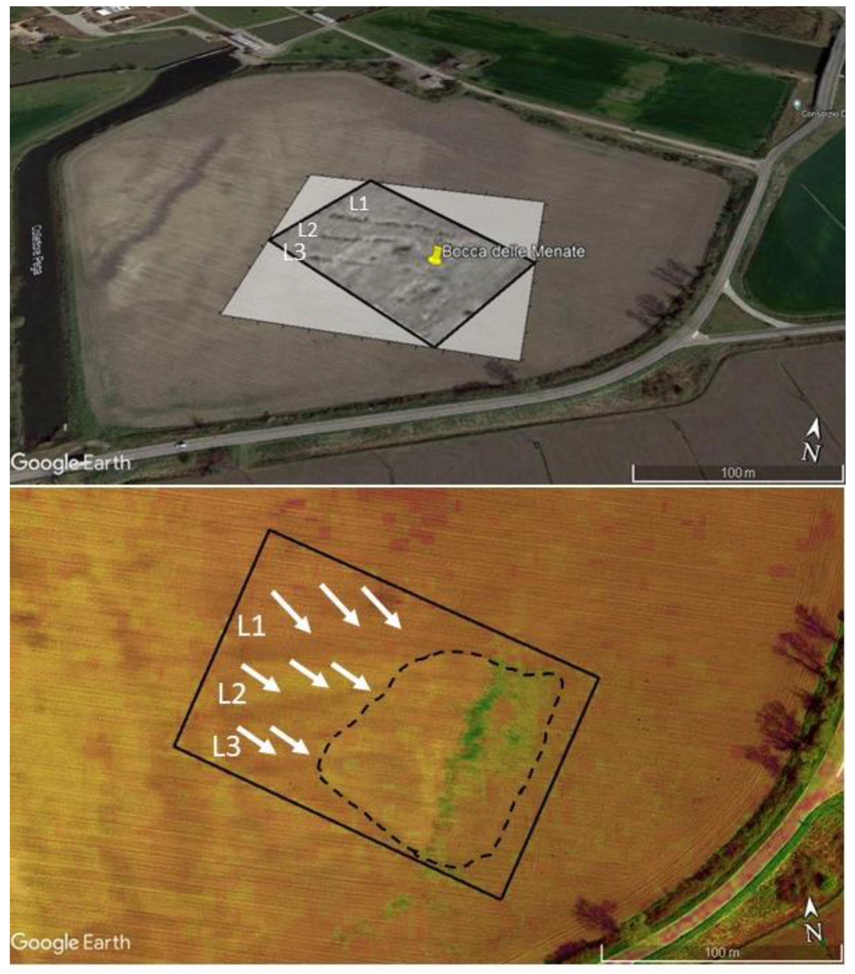
  16. Rizzo, E.; Dubbini, R.; Capozzoli, L.; De Martino, G.; Fornasari, G.; Farinatti, L.; Ferrari, E.; Clementi, J.; Fiano, F.R.; Lombardi, M. Preliminary geophysical investigation in the archaeological site of Bocca delle Menate (Comacchio, FE). J. Phys. Conf. Ser. 2022, 2204, 012107. [Google Scholar] [CrossRef]
  17. Ricci Lucchi, F.; Colalongo, M.M.; Cremonini, G.; Gasperi, G.; Iaccarino, S.; Papani, G.; Raffi, S.; Rio, D. Evoluzione sedimentaria e paleogeografica nel margine appenninico. In Guida alla Geologia del Margine Appenninico, Guide Geologiche Regionali; Cremonini, G., Ricci Lucchi, F., Eds.; Società Geologica Italiana: Bologna, Italy, 1982; pp. 17–46. [Google Scholar]
  18. Amorosi, A.; Centineo, M.C.; Colalongo, M.L.; Pasini, G.; Sarti, G.; Vaiani, S.C. Facies Architecture and Latest Pleistocene–Holocene Depositional History of the Po Delta (Comacchio Area), Italy. J. Geol. 2003, 111, 39–56. [Google Scholar] [CrossRef]
  19. Stefani, M. The Po Delta Region: Depositional Evolution, Climate Change and Human Intervention Through the Last 5000 Years. In Landscapes and Landforms of Italy; World Geomorphological Landscapes; Soldati, M., Marchetti, M., Eds.; Springer: Cham, Switzerland, 2017. [Google Scholar] [CrossRef]
  20. Dubbini, R.; Stefani, M.; Clementi, J.; Rizzo, E.; Lombardi, M.; Fiano, F.R. La villa romana di Bocca delle Menate, Comacchio. Un’esperienza di archeologia globale. Archeol. Class. 2022, 73, 481–571. [Google Scholar]
  21. Bergamini, L.; Contoli, P.; Mantovani, T.; Tieghi, L.; Zappaterra, B. Un approccio all’analisi delle tipologie insediative nel Delta. In Il complesso di Bocca delle Menate, Percorsi di Archeologia; Ferrara: Singapore, 1997; pp. 68–135. [Google Scholar]
  22. Uggeri, G. La romanizzazione nel Basso Ferrarese. Itinerari ed insediamento. In La Civiltà Comacchiese e Pomposiana Dalle Origini Preistoriche al Tardo Medioevo; Atti Convegno (Comacchio 1984): Bologna, Italy, 1986; pp. 147–181. [Google Scholar]
  23. Gelichi, S. Oltre gli empori e il ‘mare corrotto’: Comacchio e l’Adriatico tra VIII e XI secolo. In Un emporio e la Sua Cattedrale; Gli scavi di piazza XX Settembre e Villaggio San Francesco a Comacchio; Gelichi, S., Negrelli, C., Grandi, E., Eds.; All’insegna del Giglio: Florence, Italy, 2021; pp. 641–740. [Google Scholar]
  24. Clementi, J.; Fornasari, G. Metodi archeologici e geofisici a confronto: Il sito romano di Bocca delle Menate a Comacchio (FE). In Landscape3, Una Sintesi di Elementi Diacronici. Uomo e Ambiente nel Mondo Antico: Un Equilibrio Possible? Proceedings of the Conference, Bologna, Ravenna, 5–6 May 2022; 2022; Available online: http://www.topografiaantica.it/index.php/2022/04/21/landscape-3-una-sintesi-di-elementi-diacronici-uomo-e-ambiente-nel-mondo-antico-un-equilibrio-possibile-bologna-ravenna-5-6-maggio-2022/ (accessed on 1 January 2020).
  25. Uggeri, G. Carta archeologica del Territorio Ferrarese (F.° 77 III S.E.) Comacchio. In Rivista di Topografia Antica, Supplemento III, Galatina (LE); M. Congedo: Grenoble, France, 2006; pp. 54–76, 152–154. [Google Scholar]
  26. Fiano, F.R.; Ciccarella, F.; Venco, V. Studio dei reperti dalla ricognizione della villa romana Bocca delle Menate (Comacchio-FE): I contenitori da trasporto e i laterizi bollati, Annali Online Unife. Sez. Di Stor. Sci. Dell’antichità 2022, 1. [Google Scholar] [CrossRef]
  27. Terra Surveyor, Program Version 3.0.29 DW Consulting. Available online: https://arf.berkeley.edu/files/webfiles/all/arf/equipment/field/geophysical/magnetometer/terrasurveyor_manual_3029.pdf (accessed on 1 January 2020).
  28. Bartington, G.; Chapman, C.E. A high-stability fluxgate magnetic gradiometer for shallow geophysical survey applications. Archaeol. Prospect. 2004, 11, 19–34. [Google Scholar] [CrossRef]
  29. Ruiqing, D.; Jin, Y. Application of ordinary Kriging method in data processing of magnetic survey. In Proceedings of the 2012 7th International Conference on Computer Science & Education (ICCSE), Melbourne, Australia, 14–17 July 2012; pp. 771–774. [Google Scholar] [CrossRef]
  30. Friedman, S.P. Soil properties influencing apparent electrical conductivity: A review. Comput. Electron. Agric. 2005, 46, 45–70. [Google Scholar] [CrossRef]
  31. Boaga, J. The use of FDEM in hydrogeophysics: A review. J. Appl. Geophys. 2017, 139, 36–46. [Google Scholar] [CrossRef]
  32. Giannino, F.; Leucci, G. Electromagnetic Methods in Geophysics: Applications in GeoRadar, FDEM, TDEM, and AEM; John Wiley & Sons, Inc.: Hoboken, NJ, USA, 2021; p. 304. ISBN 978-1-119-77098-5. [Google Scholar]
  33. John, M. Reynolds. An Introduction to Applied and Environmental Geophysics, 2nd ed.; Wiley-Blackwell: New York, NY, USA, 2011; ISBN 978-0-471-48535-3. [Google Scholar]
  34. McNeil, J.D. Use of Electromagnetic Methods for Groundwater Studies. In Investigations in Geophysics No. 5 (Geotechnical and Environmental Geophysics, SEG Volume II: Environmental Geophysics and Groundwater); Ward, S.H., Ed.; Society of Exploration Geophysicists: Tulsa, Oklahoma, 1990; pp. 191–218. [Google Scholar]
  35. Won, I.J. A wideband electromagnetic exploration method—Some theoretical and experimental results. Geophysics 1980, 45, 928–940. [Google Scholar] [CrossRef]
Figure 1. Ubication of the Bocca delle Menate archaeological area in Comacchio village identified on a Google Maps image as part of the southern part of the Po Delta.
Heritage 06 00090 g001
Figure 2. The geological-depositional features of the Bocca delle Menate area, projected on a Google Earth image. The description is in the text.
Heritage 06 00090 g002
Figure 3. Plan of the archaeological remains in Bocca delle Menate archaeological site after the excavations in 1959 [25].
Heritage 06 00090 g003
Figure 4. Localization of the geomagnetic field area (red square) and the area investigated with electromagnetic method (green shape) on a UAV image.
Heritage 06 00090 g004
Figure 5. The GSM-19 Overhauser magnetometer used in the archaeological area.
Heritage 06 00090 g005
Figure 6. The area under study investigated with gradiometric survey using the GSM-19 Overhauser magnetometer. The yellow lines highlight the six square areas with 50 m × 50 m dimensions for each unit.
Heritage 06 00090 g006
Figure 7. The Profile AMP400 used in the archaeological area with the quad cart.
Heritage 06 00090 g007
Figure 8. Gradiometric maps acquired on the Bocca delle Menate archaeological site. The labels identified the main geomagnetic anomalies.
Heritage 06 00090 g008
Figure 9. Gradiometric maps disposed on the recent Google Maps image (top); saturation color filter applied on the Google Maps image (bottom) with limits of the previous excavations of the Bocca delle Menate archaeological site (black dashed line on the bottom). The labels L1, L2, and L3 and the across lines identified the long linear geomagnetic anomalies.
Heritage 06 00090 g009
Figure 10. Electrical conductivity maps at different frequencies (15 kHz, 9 kHz and 2 kHz) at the Bocca delle Menate archaeological site.
Heritage 06 00090 g010
Figure 11. Electrical conductivity maps coming from the quadrature components acquired at 15,000 Hz disposed on one of the available Google Earth images, where the geomorphological features are well identified.
Heritage 06 00090 g011
Disclaimer/Publisher’s Note: The statements, opinions and data contained in all publications are solely those of the individual author(s) and contributor(s) and not of MDPI and/or the editor(s). MDPI and/or the editor(s) disclaim responsibility for any injury to people or property resulting from any ideas, methods, instructions or products referred to in the content.

