Review

Landslides and Cultural Heritage—A Review

by
José Eduardo Bonini
1,*,
Bianca Carvalho Vieira
1,
Antonio Carlos de Barros Corrêa
2 and
Mauro Soldati
3,*
1
Geography Department, University of São Paulo, Avenida Professor Lineu Prestes, 338, Cidade Universitária, São Paulo 05508000, Brazil
2
Department of Geographical Sciences, Federal University of Pernambuco, Avenida Acadêmico Hélio Ramos, s/n, Cidade Universitária, Recife 50740530, Brazil
3
Department of Chemical and Geological Sciences, University of Modena and Reggio Emilia, Via Campi, 103, 41125 Modena, Italy
*
Authors to whom correspondence should be addressed.
Heritage 2023, 6(10), 6648-6668; https://doi.org/10.3390/heritage6100348
Submission received: 6 September 2023 / Revised: 28 September 2023 / Accepted: 3 October 2023 / Published: 7 October 2023
(This article belongs to the Special Issue Heritage under Threat. Endangered Monuments and Heritage Sites)

Abstract

:
Cultural heritage sites can be affected by landslides, often causing damage to their integrity, value, and accessibility. Several studies worldwide were focused on the assessment of the potential threats that landslides can pose to the preservation of cultural heritage sites. This article aims to review landslide studies at cultural heritage sites worldwide, analyzing the publications’ temporal distribution, selected methods, geographical and climate contexts, and investigated landslide types. We analyzed a database of 331 publications from 2000 to 2023 in study areas distributed across 47 countries, compiled through systematic queries of the Web of Science and Scopus catalogs. The results show an increase in the number of publications from 2012 onwards, with most studies performing landslide susceptibility analyses on cultural heritage sites. The majority of the studies deployed a geomorphological approach address slope instability mechanisms that threaten site integrity, with a significant number of publications presenting model-based, multidisciplinary and engineering geological approaches. Europe, North America, and Asia and the Pacific concentrate the majority of studies, with Italy and China having the highest number of case studies. The threats to cultural heritage sites located in Latin America and the Caribbean, and Africa are the least studied. Block slides, earth slides, and rock falls are the most studied processes, with fewer studies dealing with other landslide types.

1. Introduction

Landslides are a widespread natural process that plays an important role in the evolution of mountainous landscapes [1], being driven by gravity and triggered by climatic factors (rainfall, snowmelt, etc.) and tectonic factors (earthquakes, volcanic eruptions, etc.) [2,3,4,5,6]. As a function of landslide frequency and magnitude, built infrastructure and populations can be seriously threatened if they are exposed to landslides [3,5,7]. The occurrence of natural hazards, including landslides, has increased in the last few decades, and further increases are expected due to the effects of climate change on temperature patterns and rainfall intensity and frequency [8].
Cultural heritage can be defined as the oral and material registers inherited from past generations that document the development and way of life of the populations that created them [9,10]. According to UNESCO, cultural heritage comprises artifacts, monuments, groups of buildings, and sites that can have a multiplicity of values (scientific, ethnological, anthropological, symbolic, historic, artistic, aesthetic, etc.) [10]. Cultural heritage can be tangible or intangible, and tangible heritage can be further subdivided into immovable cultural heritage (archaeological sites, historical buildings, etc.) and movable cultural heritage (artworks, artifacts, documents, etc.) [11].
UNESCO maintains the World Heritage List (WHL) of natural, cultural, and mixed World Heritage Sites (WHS) whose value transcends national borders, thus being considered a heritage of the present and future generations of all humanity [10]. The Outstanding Universal Value (OUV) of those sites is derived from their unique scenic beauty, their importance as registers of Earth’s geological history and of the evolution of life, and their outstanding architectural features [10,12]. Currently, 1199 properties are inscribed in the UNESCO WHL in 168 countries, with 48 transnational heritage properties (https://whc.unesco.org/en/list/, accessed on 28 September 2023). Some UN countries also maintain their own list of heritage properties considered of national importance, with different regulations on the management and protection of those assets from country to country.
In the 1972 World Heritage Convention, UNESCO established the List of World Heritage in Danger (currently with 56 UNESCO WHS), aiming to raise international awareness and efforts to protect endangered sites [10,13]. As a consequence of their exposure to changing environmental conditions, cultural heritages can be subject to natural and human-induced processes that can threaten their integrity, accessibility, and value, and their protection plays a central role in the United Nations’ 2030 Agenda for Sustainable Development (Goal #11) [14,15,16,17,18,19]. Landslides are among the most significant natural threats to the integrity of the UNESCO WHS [20], and the increase in landslide frequency and magnitude can seriously threaten the integrity of archaeological sites, buildings, and architectonic complexes, and cultural landscapes [12,18].
In 2007, a UNESCO report outlined the alterations in precipitation and temperature regimes, sea-level variations, and the intensification of human-induced threats (e.g., pollution) due to climate change as threats to cultural heritage sites [12]. Shortly after the report’s publication, UNESCO issued a policy document with guiding principles for the management, monitoring, and reporting of threats to WHS aimed at raising the awareness of decision-makers, scientists, and stakeholders on the effects of climate change on WHS preservation [21]. Previous reviews summarized the state of knowledge, methodologies, and publication temporal distribution for the analysis of the effects of climate change and geohazards on cultural heritage sites, including topics on potential landslide threats. Daly [22] reviewed the impacts of climate change on archaeological sites, indicating that an increase in landslide frequency due to intense rainfall and increased ice and snow melt is a significant threat to the conservation of archaeological sites in temperate regions. Zhou et al. [23] reviewed the applications of space-borne and ground-based differential radar interferometry for deformation monitoring in cultural heritage sites and discussed the perspectives for those techniques. Nicu [9] presented a review of hydrological, geomorphological, climatic, and biotic processes that can negatively impact immovable cultural heritage. The review by Cigna et al. [24] explored the suitability of the existing datasets at global, continental, and national scales for the quantitative evaluation of geological and mining-related hazards at the UNESCO WHS of the United Kingdom.
Fatorić and Seekamp [25] performed a systematic review of the effects of climate change on cultural resources, concluding that little research was carried out in Asia, Africa, and South America and emphasizing the need for more multidisciplinary, interdisciplinary, and transdisciplinary methods in the field. Orr et al. [26] updated the review by Fatorić and Seekamp [25], showing a significant growth in interest in the topic and the inclusion of cultural heritage in climate change adaptation and mitigation strategies. However, the authors outlined that most research was performed in Europe and North America, with few instances of international cooperation between institutions located in different geopolitical regions. Sesana et al. [16] outlined that major impacts on cultural heritage can result from changes in the frequency and magnitude of natural hazards due to climate change, including landslides. The authors also highlighted a paucity of research in Asia, Africa, and Latin America.
Quesada-Ganuza et al. [27] presented a critical review of climate change risk evaluation methodologies for urban cultural heritage. The authors conclude that most research on the topic was focused on assessing the physical vulnerability of urban heritage sites to floods, indicating a gap in studies capable of integrating different dimensions of vulnerability. They also indicate the need for reviews focused on cultural heritage and individual hazards, such as wildfires, cold and heat waves, and landslides.
This article aims to review landslide studies in cultural heritage sites worldwide, analyzing the publications’ temporal distribution, selected methods, geographical and climate contexts, and landslide types. The review is focused both on the UNESCO WHS and on heritage properties not inscribed in the WHL but considered relevant at national levels. Therefore, the article is intended to provide the scientific community, policy-makers, and stakeholders with a review of landslide studies at cultural heritage sites, hence filling the gap brought forward by Quesada-Ganuza et al. [27].

2. Materials and Methods

The review process encompassed four main steps (Figure 1). First, databases were queried using a restricted set of terms to identify the most recurrent keywords used by studies focused on the analysis of landslide susceptibility, hazard, vulnerability, and risk performed at cultural heritage sites. This was carried out by trial and error using international bibliographical databases and analyzing the most frequent keywords displayed in the keywords filter. Afterward, we defined a set of synonyms for those terms based on our knowledge of the landslide science literature. Being aware of the search field constraints of each platform, the search query was focused on the publication Title, Keywords and Abstract. Database management comprised the removal of duplicated registers, the removal of non-eligible papers, and the manual inclusion of eligible publications cited in previous reviews. Next, publications were reviewed and categorized according to the study scope, approach-based categories regarding the applied methods, geographic distribution, climatic context, and analyzed landslide types.

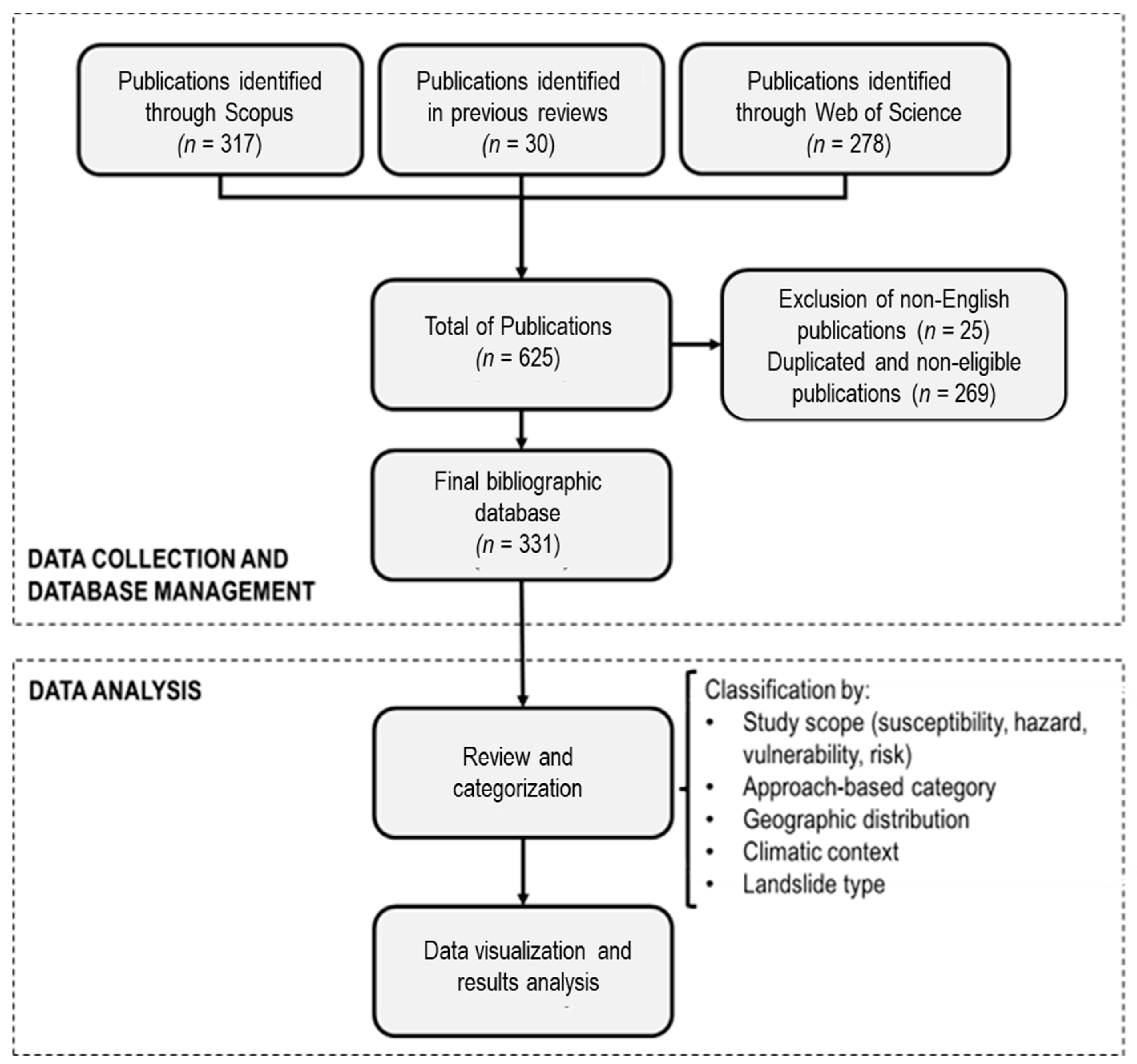
2.1. Definition of the Search Criteria, Catalog Querying, and Database Management

The Web of Science and Scopus catalogs were consulted to create the bibliographic database comprising articles, conference proceedings, and book chapters using the following search query: ({Landslid*} OR {slope deformati*} OR {slope movemen*} OR {slope instabilit*} OR {slope stabilit*} OR {mass movement*} OR {landslid* susceptibility} OR {landslid* hazard} OR {landslid* vulnerability} OR {landslid* risk} AND {Cultural heritag*} OR {Cultural-heritag*} OR {UNESCO World Heritag*} OR {archaeological heritag*}). We have considered only indexed publications in the English language. The variations of the term cultural heritage were included in the search query, aiming to identify studies in sites of cultural and historical significance that fit the scope of this review. All publications were checked for their eligibility to ensure database consistency, and Zotero performed the duplicate detection and database management.
A publication was considered eligible and included in this review if it was written in English and described a case study regarding one or more cultural heritage sites applying quantitative, qualitative, or integrated methods to analyze landslide susceptibility, hazard, vulnerability, and/or risk. To assess publication eligibility, we combined an initial screening of the title, keywords, and abstract, followed by a full-text screening for the publications that did not display enough information in their titles, abstracts, and keywords. Aiming to broaden the bibliographic database, references cited in previous reviews were thoroughly checked. Eligible references that were not detected by the search query were manually added to the database.

2.2. Publication Review and Classification

Publication review and classification was carried out by qualitative content analysis of the full text [28], aiming to outline the selected methods, scope of the case studies, geographical and climatic contexts, and the analyzed landslide type. To analyze the selected methods for landslide studies in cultural heritage sites, we defined six approach-based categories (Table 1), aiming to assemble publications that applied similar methods. This categorization mode follows the approach used by Seuring and Gold [28] for publication content analysis and that of Sarkar et al. [29] for the analysis of selected methods for the assessment of climate-related coastal risks.
Subsequently, publications were sorted by year and classified according to their scope in non-exclusive groups as susceptibility, hazard, vulnerability, or risk studies. For comparison purposes, we opted to interpret the results presented in each publication and categorize them using the following standard nomenclature for susceptibility, hazard, vulnerability, and risk:
  • Susceptibility is the spatial probability of occurrence of a given landslide type based on terrain conditions that are static over time and without considering landslide frequency and magnitude [3,30,31,32];
  • hazard is the spatiotemporal probability of the occurrence of a landslide of a given size and magnitude in a specified time frame and area, considering the probable trajectories of the landslide [3,32,33,34];
  • vulnerability is the expected degree of loss of an element or set of elements in the area affected by a specific landslide type with a given magnitude, usually obtained by analyzing the physical or socioeconomic characteristics of the exposed elements [7,32,35];
  • risk is the expected damage and loss derived from the adverse consequences of the occurrence of a landslide. For example, damages comprise casualties, damage to properties, infrastructures, cultural heritage, and the interruption of services [32]. Risk assessments result from the joint analysis of hazards and the value of the exposed elements, given by the element vulnerability [3].
Afterwards, the case studies presented in each publication were classified according to the geographical distribution, the climatic context based on the Köppen–Geiger classification, and the landslide types according to Cruden and Varnes [2]. The only addition to the latter landslide classification was the deep-seated gravitational slope deformation (DGSD) [36], which we opted to include since its occurrence was explicitly reported by some authors.
We opted to consider each case study since some publications presented one or more case studies, and the consideration of only one geographical location and climatic context per publication would be misleading. Therefore, for the geographical and climatic classifications, the reported percentages refer to the total number of case studies and not to the total number of publications. For the geographical distribution classification, we indicated the country and the UNESCO regional group of the study areas.

3. Results

In this section, the main results from the review process are presented. First, an overview of the publications by year, the study scope, and the approach-based category are provided, along with the presentation of a set of publications that are illustrative of each approach. Furthermore, the geographical distribution, the climatic context, and the landslide type of each case study are presented.

3.1. Publications by Year, Study Scope and Approach-Based Categories

The bibliographical database comprises a total of 331 papers published between 2000 and 2023. Considering the 111 papers reviewed by Nicu [9] (which also comprised hazards other than landslides), this represents an increase in the number of publications from 2017 to 2023 and indicates a substantial growth in the interest of the international scientific community on the natural threats to immovable cultural heritage.
The years with the highest number of publications are 2013 and 2015, with 33 publications each (Figure 2). This can be related to the publishing of a volume of Landslide Science and Practice in 2013 as outlined by Nicu [9] and a volume of Engineering Geology for Society and Territory in 2015. Both volumes presented a series of studies focused on the interface between natural hazards and cultural heritage sites. Up to the date we queried the publication catalogs (28 June 2023), there were 17 landslide studies in cultural heritage sites published in 2023.
The majority of publications fit the geomorphological approach (80) (Figure 2), comprising studies that applied geomorphological methods such as extensive field surveys, empirical instability mapping, and geomorphological mapping. This category displays a regular growth tendency from 2000 to 2023 (Figure 2), highlighting its importance to landslide studies in cultural heritage sites, both as final products and to subsidize future studies. This approach is the most recurrent for susceptibility analysis (31%) (Figure 3).
The first published papers in the database fit this category [37,38]. Those early works took advantage of GIS applications to integrate geological and geomorphological information, aiming to investigate the mechanisms and causative factors of landslides in the Tharos, Capo San Marco, and San Giovanni di Sinis areas (Sardinia, Italy) that could represent risks to the preservation of Roman and Phoenician heritage sites. This fundamental role of the geomorphological approach is also exemplified by the geomorphological investigations by Frodella et al. [39] in the High City of Antananarivo (Madagascar), a UNESCO WHL candidate site, which provided information for subsequent research deploying a multidisciplinary approach [40].
Model-based approaches (71) have shown consistent growth since 2013 (Figure 2), and studies in this category applied numerical simulations, semiquantitative analysis, and statistically and physically based models to assess the landslide susceptibility, hazard, and risk that cultural heritage can be faced with. Model-based approaches were extensively used in all study scopes, being deployed mainly for hazard (26%) assessments (Figure 3). Aiming to analyze the information contained in the Periodic Reports of the state of conservation of Europe’s UNESCO WHS, Valagussa et al. [41] performed a multi-hazard assessment with the analytical hierarchy process (AHP) using detailed information on different geo-hazards from Italy. The authors indicate that the Periodic Reports are a useful starting point for hazard assessments on a continental scale, with limitations such as the underestimation of threats to cultural heritage in the specific case of landslide hazards.
Nicu [42] used three different model-based approaches (AHP, frequency ratio, and statistical index) to map the landslide susceptibility in a basin of the Moldavian Plateau (NE Romania) that hosts several Neolithic archaeological sites. Expanding this study in terms of territorial coverage and understanding of landslide threats on a site-specific scale, Nicu and Asandulesei [43] employed the same methods and LiDAR, total stations, and TLS to monitor the landslide threats and validate the models’ results. They showed that nearly 70% of the sites are located in high- or very-high-susceptibility areas. Further knowledge of the landslide threats to the Neolithic sites of the Moldavian Plateau was provided by Lombardo et al. [44]. The authors employed a binomial generalized additive model to independently assess landslide and gully erosion susceptibility, applying a further procedure to create a multi-hazard map that revealed 12 sites with a high probability of the occurrence of both processes.
In Slovakia, a series of studies were performed at the Spis Castle UNESCO WHS and other cultural heritage properties [45,46]. Numerical simulations performed by Vlcko et al. [46] showed that block spreading is a significant cause of the deformations observed with instrumentation and field surveys at the Spis Castle, resulting in a modeling approach with minimal intervention on the property’s structure that can be used in stabilization plans. Among others, examples of model-based approaches are provided by studies at the Rupestrian Churches of Matera (Italy) [47,48], the Zelve Open-Air Museum (Türkiye) [49], the Chinese heritage sites of the Fortified Manors of Yongtai [50] and Mogao Caves [51], Alhambra [52], and 12 churches considered Assets of Cultural Interest of Spain [53].
Survey and monitoring using geomatic techniques (59) display a sharp increase in the number of landslide studies in cultural heritage sites after 2014 (Figure 2), being the most selected approach for hazard (29%) and vulnerability studies (25%) (Figure 3). The increase in publications that fit this approach can be related to the growing availability and affordability of geomatic survey technologies in the last decade, such as synthetic aperture radars (SAR) [54], uncrewed aerial vehicles (UAVs) [55], terrestrial laser scanners (TLS) [56], and other instruments that allow for accurate representation of slopes and buildings, aiming to identify the instability mechanisms and model the response of the endangered heritage.
We highlight the growing use of SAR technologies to monitor the interaction of landslides and cultural heritage. Under the framework of the PROTection of European Heritage from GeO-hazards (PROTEGHO) project, Themistocleous et al. [57,58] used UAV surveys and Interferometric SAR data (InSAR) to monitor landslides, presenting case studies on UNESCO WHS in different countries (United Kingdom, Spain, Italy, and Cyprus) and establishing a low-impact monitoring methodology whose application is feasible to the totality of the European UNESCO properties. Also employing InSAR techniques, Pastonchi et al. [59] presented a fast and simple regional-scale procedure with Sentinel-1 data to assess deformations caused by slow-moving landslides on the UNESCO WHS in the Tuscany region (Italy) that can be replicated on cultural heritage sites worldwide.
Combining InSAR and direct monitoring techniques in the Siq of Petra (Jordan), Delmonaco et al. [60] contributed to the establishment of a risk mitigation strategy and highlighted that the wireless network of automated crack gauges was the most reliable of the tested techniques. Other studies in this category were also performed in cultural heritage sites in Greater London (United Kingdom) [61], for the Choirokoitia UNESCO WHS (Cyprus) [62], and in Greece at the site of Delphi [63] and the Kipinas Monastery in Epirus [64], among others.
Multidisciplinary approaches (51) (Figure 2) encompass strategies to assess risk and potential damages to cultural heritage sites due to landslides, combining different scientific knowledge fields. This approach was most frequently applied to assess vulnerability (23%) and risk (24%) (Figure 3), which can be related to the necessity of assessing both the physical and social aspects to properly estimate landslide risk. The combination of different questionnaire survey techniques and geomorphological knowledge [65,66], geomorphological and geomatic information with crowdsourcing to engage the general public for cultural heritage preservation [67], and dendrogeomorphological and traditional monitoring techniques [68] are examples of the necessity to integrate several scientific disciplines to assess landslide threats on cultural heritage sites.
Combining survey techniques and crowdsourcing, Marra et al. [67] showed the potential of engaging the public and managers of cultural heritage sites at the Samnite complex of Pietrabbondante (Molise, Italy). The proposal of the SUNDAE 1.0 catalog integrates national document databases, geological and geomorphological information, and cloud-based photos and videos collected by the public that can be used to update virtual models of the sites to assess the heritage’s state of conservation while engaging the public on the preservation efforts.
Using questionnaires, Santoro et al. [66] investigated the landscape perception of two social groups (residents/workers, and farmers) about diverse threats (including hydrogeological risks) in the Islands, Cinque Terre, and Porto Venere UNESCO WHS (Italy). Land abandonment is reported by both groups as the most relevant landscape change, while landslides are frequently indicated by residents as one of the major problems. Both risk perceptions are intertwined since the lack of maintenance of terraced landscapes due to land abandonment can lead to the development of landslides [69].
Landslides are also a threat to the conservation of the Honghe Hani rice terraces (China), where crop losses are growing among local farmers [65]. In this area, farmers have a high perception of landslide risk but low levels of preparedness to deal with the effects of a landslide event such as the one triggered in 2018. The authors suggest that a stronger information dissemination strategy should be deployed to engage the local communities since they have high trust in the effectiveness of disaster risk prevention and mitigation strategies, as shown by the survey results. In a multidisciplinary study at the region of the Monte Olivetto Maggiore Abbey (Tuscany, Italy), Bollati et al. [68] combined meteorological information, monitoring data on erosion rates and landslides, and dendrochronology to understand the badlands relief morphology evolution, providing a survey that can be useful for the identification of critical areas for the installation of monitoring stations.
In the engineering geological (50 papers) category were included papers that used geophysical methods, traditional geotechnical monitoring instrumentation (piezometers, inclinometers, extensometers, etc.), geotechnical mapping, and other engineering geological methods. For example, Margottini [70] presented an in-depth geotechnical characterization of the siltstones and conglomerates of the Buddha niches in the Great Valley of Bamiyan (Afghanistan), whose giant statues were demolished by the Taliban in 2001, thus subsidizing the stabilization works described by Margottini [71].
Marinos and Tsiambaos [72] proposed a set of protective measures to mitigate rock fall hazards at the hills of Skyros Castle on the homonymous Greek island through geotechnical surveys and a model of the rock fragments probable trajectories. At the Selmun Promontory (Malta), where the Ghajn Hadid Tower ruins stand, Ianucci et al. [73] performed a detailed engineering geological field survey to characterize the joint network of the rock mass, combining this information with the results of a geophysical survey of seismic noise measurements. The results allowed to delimitate zones with different levels of instability due to the ongoing lateral spreading that threatens the stability of the tower ruins. Combining field investigations, geomechanical characterization of joint aperture and persistence, and kinematical analyses, Bozdag [74] was able to identify the zones most prone to rock falls and rock topples at the ancient site of Kilistra (Central Anatolia, Türkiye), suggesting a set of geotechnical remedial measures to improve the stability of the rock slopes.
Papers included in the index-based category (20) (Figure 2) combined data on landslide conditioning and triggering factors using different expert-based weighting strategies. This category is the least applied in all study scopes, with higher contributions to risk studies (21%) (Figure 3). In this category, some studies have analyzed the susceptibility and vulnerability of cultural heritage to multiple natural and man-made hazards. Valagussa et al. [75] applied the UNESCO Risk Index to the European UNESCO WHS properties, presenting a continental-scale multi-risk analysis. Their approach explores the available natural hazard data on the continent, providing guidelines to prioritize areas for more in-depth assessments.
Through a GIS-based approach, Brimblecombe et al. [76] presented cultural heritage susceptibility maps to different natural threats (heavy rainfall, typhoons, floods, landslides, fires, and earthquakes) under a changing climate in the Tokyo Region (Japan) and provide an evaluation of the impacts on the tourists’ experience at the cultural heritage sites. The authors indicate that 11 cultural heritage properties can be faced with negative effects from debris flows and slope failures, recommending slope maintenance and early warning systems to managers and decision-makers. Lollino and Audisio [77] provided an application example of a GIS-based empirical approach to assess cultural heritage site susceptibility to landslides and floods, presenting two case studies on the Val Germanasca Valley (Piedmont, Italy) and Crespi d’Adda (Lombardy, Italy). Their results showed the applicability of this approach for preliminary studies aiming to define priority areas for hazard assessment and monitoring.
An example of a vulnerability study using an index-based approach is brought forward by Bertolin and Sesana [78] for the 28 remaining Norwegian stave churches. Apart from traditional variables considered in vulnerability studies (building material, maintenance condition, number of floors, age, etc.), the authors also considered the susceptibility of the indoor cultural heritage (both movable and immovable) and assessed the exposure based on topographic and building variables. Their study provided an in-depth and innovative vulnerability assessment of the immovable and movable cultural heritage of the stave churches.

3.2. Case Studies Geographical Distribution, Climatic Context and Landslide Types

Some publications have presented more than one case study in areas occasionally located in different UNESCO regional groups, countries, and climatic contexts. Therefore, the percentages reported in this section are relative to the total number of case studies and not to the total number of publications. Overall, the majority of case studies were performed in the Europe and North America group and the Asia and the Pacific group, while the Africa group and the Latin America and the Caribbean group had a smaller fraction of case studies (Figure 4). One publication was performed on a global scale [20]. Pavlova et al. [20] presented a worldwide overview of geological hazards exposure in over 900 UNESCO WHS, concluding that approximately 60% of the properties are exposed to at least one type of geological hazard. Pavlova et al. [20] showed that the most vulnerable regions are Asia and the Pacific and Latin America and the Caribbean, indicating that the most frequent hazards are earthquakes and landslides.
Italy is the leading country in all approach-based categories with 112 case studies (Figure 5), being the main contributor to the high number of case studies in the Europe and North America regional group. Italy is also the country with the highest diversity of study sites, with several case studies aimed at assessing landslide threats both in UNESCO WHS sites and in Italian heritage sites that are not inscribed in the WHL [79,80,81,82,83,84]. This result suggests a higher awareness among the Italian scientific community of the potential threats to sites of cultural significance on a national level. Romania (16 papers), Greece (16), the United Kingdom (10 papers), Cyprus (9 papers), and Spain (8 papers) have a significant contribution to the higher number of publications in the Europe and North America regional group (Figure 5).
In the Asia and the Pacific regional group, the majority of case studies are from China (25) and Japan (12), with contributions from Afghanistan (8), India (4), and Iran (3) (Figure 5). China is the second country with the most properties inscribed in the UNESCO WHL (57) and also ranks second in the number of case studies in this review. China is one the countries with the highest numbers of papers and study areas where statistically based landslide susceptibility models have been deployed, as shown by Reichenbach et al. [85] in their review of landslide susceptibility using data-driven models. This can be also explicative of both the number of Chinese case studies and the diversity of studied cultural heritage sites. In Japan, the concern with the interaction between landslides and cultural heritage can be a consequence of the strong legal framework for landslide risk mitigation in general, for example, the 2001 Sediment Disaster Prevention Law, the Landslide Prevention Law, and the Law for Prevention of Steep Slope Failure Disaster [86].
The Arab States regional group ranks third with eight countries (Jordan, Algeria, Egypt, Tunisia, Syria, Iraq, Lebanon, and Saudi Arabia), with the majority of case studies from Jordan (15), Algeria (3), and Egypt (3). Only two countries from the Africa group (Ethiopia and Madagascar) and four from Latin America and the Caribbean group (Peru, Chile, Argentina, and Bolivia) have landslide case studies in cultural heritage sites (Figure 5).
Four of the top 10 countries with the most case studies (Figure 5) are not located in the Europe and North America Group (China, Peru, Jordan, and Japan). This result should be analyzed carefully, given that a high number of publications does not necessarily mean a diversity of study areas. Except for China and Japan, most of the studies on the abovementioned countries were conducted on the same heritage sites: Machu Picchu in Peru (15 out of 16 case studies), and the Siq of Petra in Jordan (all case studies in Jordan). This concentration of case studies on the same heritage property can be perceived in other areas, such as the Buddha niches of the Bamiyan Valley UNESCO WHS in Afghanistan (7 of the 8 case studies), Katskhi Pillar and Vardzia Monasteries in Georgia (11 out of 12 case studies), and the High City of Antananarivo in Madagascar (all case studies).
Regarding the climatic context, the category “Not Applicable” (Figure 6) refers to case studies carried out on global, continental, national, or regional scales that do not allow the definition of one single climatic type under the Köppen–Geiger classification. The majority of the reviewed case studies were performed in hot-summer Mediterranean and temperate oceanic climates (23.63% and 18.13%, respectively) (Figure 6). Humid subtropical (14.01%), warm-summer humid continental (9.62%), and warm-summer Mediterranean (7.14%) climates accounted for a relevant share of the amount of landslide case studies in cultural heritage sites. Tropical, arctic, and monsoon-influenced climates figure among the less studied climatic contexts (Figure 6). Only six case studies were performed in areas under a tropical climate and 14 in monsoon-influenced contexts.
For the landslide types, the “Not applicable” class encompasses studies performed at continental and global scales that do not allow for the differentiation of landslide type (Figure 7). A total of 6.8% of the case studies did not indicate the landslide type using common and accepted taxonomies (Figure 7). Case studies that did not indicate the landslide type most frequently deployed a model-based approach.
Translational slide and fall are the most studied types of mass movement in cultural heritage sites (28.9% and 21.8%, respectively) (Figure 7). More specifically, the majority of case studies analyzed the potential threats from block slides, earth slides, and rock falls. The selected methods for assessing translational slide and fall threats to heritage sites were similar, mainly the geomorphological approach and survey and monitoring using geomatic techniques (Figure 7). Examples of selected methods are detailed geomorphological mapping, extensive field campaigns, UAV digital photogrammetry, and TLS surveys to investigate the landslide mechanisms and potential damage to heritage sites [64,87,88,89,90,91,92,93]. A minority of case studies opted for index-based methods.
A total of 12.1% of the case studies were dedicated to debris flow and earth flow, usually assessed by a geomorphological approach and a multidisciplinary approach (Figure 7). Different from other landslide types, several papers aimed to reconstruct past flow events using the abovementioned approaches to understand the reactivation regime and the mobilized material source areas [52,94,95,96].
Soil and rock spreading and deep-seated gravitational slope deformation (DGSD) were analyzed in fewer case studies in comparison to other landslide types (Figure 7). Rock spreading and DGSD have a similar pattern of selected methods, which is associated with the slow to very slow velocity rates of those processes. This characteristic of lateral spreading and DGSD allows scientists to deploy a diversity of monitoring instrumentation, such as inclinometers and piezometers, GNSS networks, and different types of SAR data analysis [62,97,98,99,100].

4. Discussion

Based on the results of the review process, we highlight that important progress has been made in the last few decades, aiming to understand the hazard and vulnerability components of landslide risk in cultural heritage sites. The challenge seems to be the translation of scientific knowledge into public policies to safeguard cultural heritage sites. Engaging the populations that are economically and socially dependent on the conservation of cultural heritage value, tourists, and other stakeholders in the preservation efforts can be a viable option to raise society’s awareness and may reflect in political action.
Concerning the selected methods and approaches, we note an expansion of the use of geomatic survey and monitoring techniques in the last decade, mainly the use of UAV digital photogrammetry, laser survey techniques, and SAR-based methods. However, most of this kind of research is restricted to the more studied countries located in Europe and North America and the Asia and Pacific regional groups. Future studies could benefit from the use of those methods in the least studied regional groups, especially in less favored countries that usually lack an updated environmental database at adequate scales for the analysis of landslide exposure to cultural heritage sites. The method selection and study design should take into consideration the regional context of each cultural heritage site, which kind of landslide is under analysis, the scale and objectives of the landslide assessment, and the financial resources available for the project. Considering the heterogeneity of geomorphological and climatic contexts and the diversity of cultural heritage sites in the selected publications, it is not feasible to suggest a need for one specific approach. Instead, it is necessary to tailor the methods deployed according to the type of cultural heritage under threat and the expertise of each group of scientists.
The leading role of the Europe and North America group can be associated with transnational cooperation projects aimed at safeguarding cultural assets, of which PROTEGHO, HORIZONS, ARCHYTAS, PANOPTIS, HYPERION, and INFRASTRESS projects are examples. Those initiatives resulted in several publications and solid know-how on the geomatic survey, model-based approaches, vulnerability, and risk assessments, as well as strengthening public policies to safeguard the European cultural heritage. The strong transnational cooperation in the European Union to safeguard cultural heritage assets may be explicative of the fact that national- and continental-scale landslide studies were only identified for Europe [24,41,75,101,102].
We note a gap for landslide studies in cultural heritage sites in Africa, Latin America, and the Caribbean, the Arab States UNESCO group of countries, and in areas with tropical and monsoon-dominated climates. Despite the number of case studies in the Arab States regional group, most of the research was aimed at assessing rock-fall threats in the Siq of Petra (Jordan), implying a gap in knowledge of landslide threats to other heritage sites of the Arab States. This scarcity of research in Africa and Latin America and the Caribbean was also noted by Fatorić and Seekamp [25], Sesana et al. [16], and Orr et al. [26] in their reviews on the effects of climate change on cultural heritage sites.
The geological context of the investigated areas was not taken into consideration due to the diversity of study scales and scopes in the reviewed papers. During the study design process, we actually considered the inclusion of the geological and tectonic contexts in the list of determinants to be extracted from each publication. However, it proved very difficult to ascertain the geological context of the study areas due to the highly heterogeneous form in which this information was reported by the authors of the selected articles. Moreover, due to the disparity in the study scale between publications (from single cultural heritage properties up to global-scale studies), reporting a simplified geological context for each case study could have been potentially misleading. The same applies to the tectonic context. In fact, it could have been misleading to provide a differentiation between active tectonic regions and stable platform contexts, especially for areas where both rainfall events and earthquakes can trigger (and have triggered in the past) landslides, such as in the Mediterranean region (the area with the most landslide studies in cultural heritage sites in our review). Nevertheless, we believe that the classification of studies by landslide type presented in the review can provide readers with insights into the most and least studied geological contexts.
A restricted number of studies in our database analyzed the possible impact on cultural heritage sites due to multiple-occurrence regional landslide events (MORLE) [103], none of them in humid tropical environments where MORLE is relatively frequent. Furthermore, high-energy landslides with a long runout, such as debris flow and earth flow, were analyzed in a restricted number of case studies in comparison with rock falls and translational slides, which we associate with the scarcity of studies in cultural heritage sites under tropical and monsoon-dominated climatic contexts.
From the analysis of the results, we note that international cooperation has advanced the understanding of landslide threats to cultural heritage sites located in the less-studied UNESCO regional groups. Therefore, international cooperation between scientists from less favored countries with their pairs based on the more studied countries can be a promising route to overcome the knowledge gap about the threats posed by landslides to cultural heritage sites in less favored countries. Several case studies in the Africa and Arab States regional groups resulted from international cooperation projects with teams from more favored countries. The studies performed on the Lalibela Rock-Hewn Churches UNESCO WHS in Ethiopia [104,105,106,107] and in Tunisia (the Dougga/Thugga site) [108] benefited from the cooperation of local experts with Italian ones under the framework of interdisciplinary projects, mainly coordinated by UNESCO.
The same applies to the publications about the High City of Antananarivo, which benefited from the cooperation between experts from different countries in the framework of the “Project for Enrollment of the High City of Antananarivo in the UNESCO World Heritage Site” of the UNESCO chair on Prevention and Sustainable Management of Geo-Hydrological Hazards [39,40,109]. In Latin America and the Caribbean, international cooperation under the framework of the International Consortium on Landslides and the International Programme on Landslides C101-1 resulted in the already mentioned case studies in the Inca citadel of Machu Picchu [110,111,112,113], involving Peruvian, Japanese, Czechoslovakian, and Italian experts [114].

5. Conclusions

This research was focused on the review of publications dealing with cultural heritage sites affected by landslides worldwide. The analysis of the bibliographical database allowed us to outline the most studied regions and climatic contexts, the most frequently selected methods, and the most analyzed landslide types. The highest number of studies have been carried out in Europe, North America, Asia, and the Pacific—Italy and China being the topmost—while the least studied areas are located in Africa and Latin America and the Caribbean UNESCO regional groups of countries, a picture already depicted by previous reviews. Moreover, we highlight a gap in studies aimed at assessing the potential landslide threat to cultural heritage under tropical and monsoon-dominated climatic contexts. Most of the research conducted in Africa, the Arab States, and in Latin America and the Caribbean groups has the same cultural heritage property as the study area. Therefore, it is necessary to broaden the range of studied properties to properly identify the real landslide exposure of the cultural heritage in Africa, Latin America and the Caribbean, and the Arab States groups. The diversification of study sites may also contribute to understanding how different landslide dynamics can impact cultural heritage, a piece of information that could be useful for adaptation strategies in the more studied regions.
We highlight that the cooperation between scientists from countries with different socioeconomic and academic contexts has already resulted in papers that have provided important contributions to the understanding of landslide threats to heritage sites. As indicated in the United Nations SDG #17, a promising route to overcome the gaps presented in this review may be the strengthening of international cooperation between scientists from less-favored countries and excellence centers in the most studied countries, including the indigenous communities and knowledge in the prevention and adaptation strategies. It should be underlined that the use of virtual technologies (for example, https://www.geovt.eu/, accessed on 28 September 2023) would also be beneficial in enhancing the above-mentioned cooperation by providing the means for virtual field activities and for the training of a new generation of scientists dealing with the potential impact of geohazards on cultural heritage.

Author Contributions

Conceptualization, J.E.B., M.S., B.C.V. and A.C.d.B.C.; methodology, J.E.B. and M.S.; software, J.E.B.; validation, J.E.B.; formal analysis, J.E.B.; investigation, J.E.B.; data curation, J.E.B.; writing—original draft preparation, J.E.B., M.S., B.C.V. and A.C.d.B.C.; writing—review and editing, J.E.B., M.S., B.C.V. and A.C.d.B.C.; visualization, J.E.B., M.S. and B.C.V.; supervision, M.S., B.C.V. and A.C.d.B.C.; project administration, J.E.B., M.S., B.C.V. and A.C.d.B.C.; funding acquisition, J.E.B., M.S. and B.C.V. All authors have read and agreed to the published version of the manuscript.

Funding

This research was funded by the São Paulo Research Foundation (FAPESP) in the frame of the Ph.D. research currently being developed at the University of São Paulo and the Research Internship Abroad at the University of Modena and Reggio Emilia (grant #2021/04621–6 and grant #2022/13591-6). The research was also carried out in the frame of the project “Training new generations on geomorphology, geohazards and geoheritage through Virtual Reality Technologies” (GeoVT) under the Erasmus + Programme, Key Action 2: Partnerships for Cooperation (Agreement number: 2021-1-SE01-KA220HED-000032142)—Coordinator: Arjen Stroeven (University of Stockholm); Partner organization leader: Mauro Soldati (University of Modena and Reggio Emilia).

Data Availability Statement

No new data were created or analyzed in this study. Data sharing is not applicable to this article.

Acknowledgments

This research originates from a collaboration between the Graduate Program in Physical Geography of the University of São Paulo (Brazil) and the Department of Chemical and Geological Sciences of the University of Modena and Reggio Emilia (Unimore) (Italy) in the frame of the Research Internship Abroad funded by the FAPESP (grant #2022/13591-6, São Paulo Research Foundation). We also thank Vittoria Vandelli (Unimore) for her valuable insights on how to correctly query international bibliographical platforms and manage large bibliographical databases.

Conflicts of Interest

The authors declare no conflict of interest.

References

  1. Crozier, M.J. Landslide Geomorphology: An Argument for Recognition, with Examples from New Zealand. Geomorphology 2010, 120, 3–15. [Google Scholar] [CrossRef]
  2. Cruden, D.M.; Varnes, D.J. Landslide Types and Processes. In Landslides and Engineering Practice; Turner, A.K., Schuster, R.L., Eds.; Special Report, 247, 36–75; Transportation Research Board, US National Academy of Sciences: Washington, DC, USA, 1996; Volume 24, pp. 20–47. ISBN 0-309-06208-X. [Google Scholar]
  3. Crozier, M.J.; Glade, T. Landslide Hazard and Risk: Issues, Concepts and Approach. In Landslide Hazard and Risk; Glade, T., Anderson, M., Crozier, M.J., Eds.; Wiley: Hoboken, NJ, USA, 2005; pp. 1–40. ISBN 978-0-471-48663-3. [Google Scholar]
  4. Borgatti, L.; Soldati, M. Landslides and Climatic Change. In Geomorphological Hazards and Disaster Prevention; Alcántara-Ayala, I., Goudie, A.S., Eds.; Cambridge University Press: Cambridge, MA, USA, 2010; pp. 87–95. ISBN 978-0-521-76925-9. [Google Scholar]
  5. Froude, M.J.; Petley, D.N. Global Fatal Landslide Occurrence 2004 to 2016. Nat. Hazards Earth Syst. Sci. Discuss. 2018, 8, 1–44. [Google Scholar] [CrossRef]
  6. Micu, M.; Micu, D.; Soldati, M. Mass Movements in Changing Mountainous Environments. In Treatise on Geomorphology; Shroder, J.F., Ed.; Academic Press: Cambridge, MA, USA, 2022; pp. 371–388. ISBN 978-0-08-088522-3. [Google Scholar]
  7. Corominas, J.; van Westen, C.; Frattini, P.; Cascini, L.; Malet, J.-P.; Fotopoulou, S.; Catani, F.; Van Den Eeckhaut, M.; Mavrouli, O.; Agliardi, F.; et al. Recommendations for the Quantitative Analysis of Landslide Risk. Bull. Eng. Geol. Environ. 2014, 73, 209–263. [Google Scholar] [CrossRef]
  8. Masson-Delmonte, V.; Zhai, P.; Pirani, A.; Connors, S.L.; Péan, C.; Berger, S.; Caud, N.; Chen, Y.; Goldfarb, L.; Gomis, M.I.; et al. Climate Change 2021: The Physical Science Basis. Contribution of Working Group I to the Sixth Assessment Report of the Intergovernmental Panel on Climate Change, 1st ed.; Cambridge University Press: Cambridge, United Kingdom; New York, NY, USA, 2021. [Google Scholar]
  9. Nicu, I.C. Natural Hazards—A Threat for Immovable Cultural Heritage. A Review. Int. J. Conserv. Sci. 2017, 8, 375–388. [Google Scholar]
  10. UNESCO. Convention Concerning the Protection of the World Cultural and Natural Heritage; UNESCO World Heritage Centre: Paris, France, 1972. [Google Scholar]
  11. UNESCO; ICCROM; ICOMOS; IUCN. Managing Disaster Risks for World Heritage; UNESCO: Paris, France, 2010. [Google Scholar]
  12. UNESCO World Heritage Centre. Climate Change and World Heritage: Report on Predicting and Managing the Impacts of Climate Change on World Heritage and Strategy to Assist States Parties to Implement Appropriate Management Responses; World Heritage Reports: Paris, France, 2007. [Google Scholar]
  13. UNESCO Convention Concerning the Protection of the World Cultural and Natural Heritage. Thirty-Third Session of the World Heritage Committee; UNESCO World Heritage Centre: Paris, France, 2009. [Google Scholar]
  14. United Nations. Transforming Our World: The 2030 Agenda for Sustainable Development A/RES/70/1; United Nations: New York, NY, USA, 2015. [Google Scholar]
  15. Bertolin, C. Preservation of Cultural Heritage and Resources Threatened by Climate Change. Geosciences 2019, 9, 250. [Google Scholar] [CrossRef]
  16. Sesana, E.; Gagnon, A.S.; Ciantelli, C.; Cassar, J.; Hughes, J.J. Climate Change Impacts on Cultural Heritage: A Literature Review. Wiley Interdiscip. Rev.-Clim. Change 2021, 12, e710. [Google Scholar] [CrossRef]
  17. ICOMOS, International Council on Monuments and Sites. World Report 2000 on Monuments and Sites in Danger; ICOMOS: Berlin, Germany, 2000. [Google Scholar]
  18. ICOMOS, Climate Change and Cultural Heritage Working Group. The Future of Our Pasts: Engaging Cultural Heritage in Climate Action; ICOMOS: Paris, France, 2019. [Google Scholar]
  19. ICOMOS International Council on Monuments and Sites. Heritage at Risk: World Report 2016–2019 on Monuments and Sites in Danger; Hendrik Bäßler Verlag: Berlin, Germany, 2020; ISBN 978-3-945880-67-8. [Google Scholar]
  20. Pavlova, I.; Makarigakis, A.; Depret, T.; Jomelli, V. Global Overview of the Geological Hazard Exposure and Disaster Risk Awareness at World Heritage Sites. J. Cult. Herit. 2017, 28, 151–157. [Google Scholar] [CrossRef]
  21. UNESCO, World Heritage Centre Policy Document on the Impacts of Climate Change on World Heritage Properties. Document WHC-07/16.GA/10 Adopted by the 16th General Assembly of State Parties to the World Heritage Convention (October 2007); UNESCO World Heritage Centre: Paris, France, 2008. [Google Scholar]
  22. Daly, C. Climate Change and the Conservation of Archaeological Sites: A Review of Impacts Theory. Conserv. Manag. Archaeol. Sites 2011, 13, 293–310. [Google Scholar] [CrossRef]
  23. Zhou, W.; Chen, F.; Guo, H. Differential Radar Interferometry for Structural and Ground Deformation Monitoring: A New Tool for the Conservation and Sustainability of Cultural Heritage Sites. Sustainability 2015, 7, 1712–1729. [Google Scholar] [CrossRef]
  24. Cigna, F.; Tapete, D.; Lee, K. Geological Hazards in the UNESCO World Heritage Sites of the UK: From the Global to the Local Scale Perspective. Earth-Sci. Rev. 2018, 176, 166–194. [Google Scholar] [CrossRef]
  25. Fatorić, S.; Seekamp, E. Are Cultural Heritage and Resources Threatened by Climate Change? A Systematic Literature Review. Clim. Change 2017, 142, 227–254. [Google Scholar] [CrossRef]
  26. Orr, S.A.; Richards, J.; Fatorić, S. Climate Change and Cultural Heritage: A Systematic Literature Review (2016–2020). Hist. Environ. Policy Pract. 2021, 12, 434–477. [Google Scholar] [CrossRef]
  27. Quesada-Ganuza, L.; Garmendia, L.; Roji, E.; Gandini, A. Do We Know How Urban Heritage Is Being Endangered by Climate Change? A Systematic and Critical Review. Int. J. Disaster Risk Reduct. 2021, 65, 102551. [Google Scholar] [CrossRef]
  28. Seuring, S.; Gold, S. Conducting Content-analysis Based Literature Reviews in Supply Chain Management. Supply Chain Manag. Int. J. 2012, 17, 544–555. [Google Scholar] [CrossRef]
  29. Sarkar, N.; Rizzo, A.; Vandelli, V.; Soldati, M. A Literature Review of Climate-Related Coastal Risks in the Mediterranean, a Climate Change Hotspot. Sustainability 2022, 14, 15994. [Google Scholar] [CrossRef]
  30. Brabb, E.E. Innovative Approaches to Landslide Hazard Mapping. In Proceedings of the 4th International Symposium on Landslides, Toronto, ON, Canada, 16–21 September 1984; pp. 307–324. [Google Scholar]
  31. Guzzetti, F.; Carrara, A.; Cardinali, M.; Reichenbach, P. Landslide Hazard Evaluation: A Review of Current Techniques and Their Application in a Multi-Scale Study, Central Italy. Geomorphology 1999, 31, 181–216. [Google Scholar] [CrossRef]
  32. Hervás, J.; Bobrowsky, P. Mapping: Inventories, Susceptibility, Hazard and Risk. In Landslides—Disaster Risk Reduction; Sassa, K., Canuti, P., Eds.; Springer: Berlin/Heidelberg, Germany, 2005; pp. 321–349. ISBN 978-3-540-69966-8. [Google Scholar]
  33. Hartlen, J.; Viberg, L. General Report: Evaluation of Land- Slide Hazard. In Proceedings of the V International Symposium on Landslides, Lausanne, Switzerland, 10–15 July 1988; pp. 1037–1057. [Google Scholar]
  34. Soeters, R.; van Westen, C.J. Slope Instability Recognition, Analysis, and Zonation. Landslides Investig. Mitig. 1996, 129–177. [Google Scholar]
  35. Van Westen, C.J.; van Asch, T.W.J.; Soeters, R. Landslide Hazard and Risk Zonation—Why Is It Still so Difficult? Bull. Eng. Geol. Environ. 2006, 65, 167–184. [Google Scholar] [CrossRef]
  36. Soldati, M. Deep-Seated Gravitational Slope Deformation. In Encyclopedia of Natural Hazards; Bobrowsky, P.T., Ed.; Encyclopedia of Earth Sciences Series; Springer: Dordrecht, Germany; New York, NY, USA, 2013; pp. 151–155. ISBN 978-90-481-8699-0. [Google Scholar]
  37. Canuti, P.; Casagli, N.; Catani, F.; Fanti, R. Hydrogeological Hazard and Risk in Archaeological Sites: Some Case Studies in Italy. J. Cult. Herit. 2000, 1, 117–125. [Google Scholar] [CrossRef]
  38. Fanti, R. Geomorphological Hazard in the Tharros Archaeological Area (Western Sardinia, Italy). In Proceedings of the Geoarchaeology of the Landscapes of Classical Antiquity, Ghent, Belgium, 23–24 October 1998; Peeters Vermeulen, F., De Dapper, M., Eds.; Peeters Publishers: Leuven, Belgium, 2000; pp. 85–95. [Google Scholar]
  39. Frodella, W.; Spizzichino, D.; Andrea, C.; Claudio, M.; Nicola, C. Hydrography and Geomorphology of Antananarivo High City (Madagascar). J. Maps 2021, 17, 215–226. [Google Scholar] [CrossRef]
  40. Frodella, W.; Rosi, A.; Spizzichino, D.; Nocentini, M.; Lombardi, L.; Ciampalini, A.; Vannocci, P.; Ramboason, N.; Margottini, C.; Tofani, V.; et al. Integrated Approach for Landslide Hazard Assessment in the High City of Antananarivo, Madagascar (UNESCO Tentative Site). Landslides 2022, 19, 2685–2709. [Google Scholar] [CrossRef]
  41. Valagussa, A.; Frattini, P.; Crosta, G.B.; Spizzichino, D.; Leoni, G.; Margottini, C. Hazard Ranking of the UNESCO World Heritage Sites (WHSs) in Europe by Multicriteria Analysis. J. Cult. Herit. Manag. Sustain. Dev. 2020, 10, 359–374. [Google Scholar] [CrossRef]
  42. Nicu, I.C. Application of Analytic Hierarchy Process, Frequency Ratio, and Statistical Index to Landslide Susceptibility: An Approach to Endangered Cultural Heritage. Environ. Earth Sci. 2018, 77, 79. [Google Scholar] [CrossRef]
  43. Nicu, I.C.; Asandulesei, A. GIS-Based Evaluation of Diagnostic Areas in Landslide Susceptibility Analysis of Bahluiet River Basin (Moldavian Plateau, NE Romania). Are Neolithic Sites in Danger? Geomorphology 2018, 314, 27–41. [Google Scholar] [CrossRef]
  44. Lombardo, L.; Tanyas, H.; Nicu, I.C. Spatial Modeling of Multi-Hazard Threat to Cultural Heritage Sites. Eng. Geol. 2020, 277, 105776. [Google Scholar] [CrossRef]
  45. Greif, V.; Drotar, T. Static and Pseudo Static Stability Analysis of the Medieval Castle Rock Slopes in Slovakia. In Landslide Science and Practice; Margottini, C., Canuti, P., Sassa, K., Eds.; Springer: Berlin/Heidelberg, Germany, 2013; pp. 435–440. ISBN 978-3-642-31318-9. [Google Scholar]
  46. Vlcko, J.; Greif, V.; Grof, V.; Jezny, M.; Petro, L.; Brcek, M. Rock Displacement and Thermal Expansion Study at Historic Heritage Sites in Slovakia. Environ. Geol. 2009, 58, 1727–1740. [Google Scholar] [CrossRef]
  47. Pascale, S.; Pastore, V.; Sdao, F.; Sole, A. Landslide Susceptibility in Archaeological and Natural Historic Park of Rupestrian Churches. In Proceedings of the Landslide Science and Practice: Risk Assessment, Management and Mitigation 2013; Springer: Berlin/Heidelberg, Germany, 2013; Volume 6, pp. 715–722. [Google Scholar]
  48. Sdao, F.; Lioi, D.S.; Pascale, S.; Caniani, D.; Mancini, I.M. Landslide Susceptibility Assessment by Using a Neuro-Fuzzy Model: A Case Study in the Rupestrian Heritage Rich Area of Matera. Nat. Hazards Earth Syst. Sci. 2013, 13, 395–407. [Google Scholar] [CrossRef]
  49. Kasmer, O.; Ulusay, R.; Genis, M. Assessments on the Stability of Natural Slopes Prone to Toe Erosion, and Man-Made Historical Semi-Underground Openings Carved in Soft Tuffs at Zelve Open-Air Museum (Cappadocia, Turkey). Eng. Geol. 2013, 158, 135–158. [Google Scholar] [CrossRef]
  50. Yang, J.; You, Y.; Ye, X.; Lin, J. Cultural Heritage Sites Risk Assessment Based on RS and GIS—Takes the Fortified Manors of Yongtai as an Example. Int. J. Disaster Risk Reduct. 2023, 88, 103593. [Google Scholar] [CrossRef]
  51. Zhang, L.; Wang, Y.; Zhang, J.; Zhang, S.; Guo, Q. Rockfall Hazard Assessment of the Slope of Mogao Grottoes, China Based on AHP, F-AHP and AHP-TOPSIS. Environ. Earth Sci. 2022, 81, 377. [Google Scholar] [CrossRef]
  52. Fernandez-Merodo, J.A.; Mateos, R.M.; Azañon, J.M.; Ezquerro, P.; García-Davalillo, J.C.; Bejar, M.; Herrera, G.; Novo, C.; Bee, E.; Themistocleous, K.; et al. Multiscale Analysis of Geo-Hazards Affecting the Alhambra Cultural Heritage; Springer: Heidelberg, Germany, 2023; pp. 47–61. [Google Scholar] [CrossRef]
  53. Moreno, M.; Ortiz, R.; Cagigas-Muñiz, D.; Becerra, J.; Martin, J.M.; Prieto, A.J.; Garrido-Vizuete, M.A.; Macías-Bernal, J.M.; Chávez, M.J.; Ortiz, P. ART-RISK 3.0 a Fuzzy—Based Platform That Combine GIS and Expert Assessments for Conservation Strategies in Cultural Heritage. J. Cult. Herit. 2022, 55, 263–276. [Google Scholar] [CrossRef]
  54. Mondini, A.C.; Guzzetti, F.; Chang, K.-T.; Monserrat, O.; Martha, T.R.; Manconi, A. Landslide Failures Detection and Mapping Using Synthetic Aperture Radar: Past, Present and Future. Earth-Sci. Rev. 2021, 216, 103574. [Google Scholar] [CrossRef]
  55. Colomina, I.; Molina, P. Unmanned Aerial Systems for Photogrammetry and Remote Sensing: A Review. ISPRS J. Photogramm. Remote Sens. 2014, 92, 79–97. [Google Scholar] [CrossRef]
  56. Telling, J.; Lyda, A.; Hartzell, P.; Glennie, C. Review of Earth Science Research Using Terrestrial Laser Scanning. Earth-Sci. Rev. 2017, 169, 35–68. [Google Scholar] [CrossRef]
  57. Themistocleous, K.; Cuca, B.; Agapiou, A.; Lysandrou, V.; Tzouvaras, M.; Hadjimitsis, D.G.; Kyriakides, P.; Kouhartsiouk, D.; Margottini, C.; Spizzichino, D.; et al. The Protection of Cultural Heritage Sites from Geo-Hazards: The PROTHEGO Project. Lect. Notes Comput. Sci. 2016, 10059 LNCS, 91–98. [Google Scholar] [CrossRef]
  58. Themistocleous, K.; Danezis, C.; Mendonidis, E.; Lymperopoulou, E. Monitoring Ground Deformation of Cultural Heritage Sites Using UAVs and Geodetic Techniques: The Case Study of Choirokoitia, JPI PROTHEGO Project. In Proceedings of the Earth Resources and Environmental Remote Sensing/GIS Applications VIII, Warsaw, Poland, 12–14 September 2017; Michel, U., Schulz, K., Nikolakopoulos, K., Civco, D., Eds.; Curran Associates: Red Hook, NY, USA, 2017; Volume 10428. [Google Scholar]
  59. Pastonchi, L.; Barra, A.; Monserrat, O.; Luzi, G.; Solari, L.; Tofani, V. Satellite Data to Improve the Knowledge of Geohazards in World Heritage Sites. Remote Sens. 2018, 10, 992. [Google Scholar] [CrossRef]
  60. Delmonaco, G.; Brini, M.; Cesaro, G. Advanced monitoring systems for landslide risk reduction in the ‘Siq’ of Petra (Jordan). In Proceedings of the ICOMOS/ISPRS International Scientific Committee on Heritage Documentation (CIPA) 26TH International CIPA Symposium—Digital Workflows for Heritage Conservation, Ottawa, ON, Canada, 28 August–1 September 2017; Hayes, J., Ouimet, C., Quintero, M., Fai, S., Smith, L., Eds.; UNESCO: Paris, France, 2017; Volume 42-2, pp. 163–169. [Google Scholar]
  61. Cigna, F.; Jordan, H.; Bateson, L.; McCormack, H.; Roberts, C. Natural and Anthropogenic Geohazards in Greater London Observed from Geological and ERS-1/2 and ENVISAT Persistent Scatterers Ground Motion Data: Results from the EC FP7-SPACE PanGeo Project. Pure Appl. Geophys. 2015, 172, 2965–2995. [Google Scholar] [CrossRef]
  62. Themistocleous, K.; Danezis, C.; Gikas, V. Monitoring Ground Deformation of Cultural Heritage Sites Using SAR and Geodetic Techniques: The Case Study of Choirokoitia, Cyprus. Appl. Geomat. 2021, 13, 37–49. [Google Scholar] [CrossRef]
  63. Devlioti, K.; Christaras, B.; Marinos, V.; Vouvalidis, K.; Giannakopoulos, N. Kinematic Analysis of Rock Instability in the Archaeological Site of Delphi Using Innovative Techniques. In Transdisciplinary Multispectral Modeling and Cooperation for the Preservation of Cultural Heritage; Moropoulou, A., Korres, M., Georgopoulos, A., Spyrakos, C., Mouzakis, C., Eds.; Springer International Publishing: Cham, Switzerland, 2019; Volume 962, pp. 407–418. ISBN 978-3-030-12959-0. [Google Scholar]
  64. Konstantinidis, I.; Marinos, V.; Papathanassiou, G. UAV-Based Evaluation of Rockfall Hazard in the Cultural Heritage Area of Kipinas Monastery, Greece. Appl. Sci. 2021, 11, 8946. [Google Scholar] [CrossRef]
  65. Gao, X.; Roder, G.; Jiao, Y.; Ding, Y.; Liu, Z.; Tarolli, P. Farmers’ Landslide Risk Perceptions and Willingness for Restoration and Conservation of World Heritage Site of Honghe Hani Rice Terraces, China. Landslides 2020, 17, 1915–1924. [Google Scholar] [CrossRef]
  66. Santoro, A.; Venturi, M.; Agnoletti, M. Landscape Perception and Public Participation for the Conservation and Valorization of Cultural Landscapes: The Case of the Cinque Terre and Porto Venere UNESCO Site. Land 2021, 10, 93. [Google Scholar] [CrossRef]
  67. Marra, A.; Fabbrocino, G.; Fabbrocino, S. Conservation and Enhancement of the Pietrabbondante Archaeological Site between History, Geology and Emerging Crowd-Based Digital Technologies. Heritage 2022, 5, 1504–1528. [Google Scholar] [CrossRef]
  68. Bollati, I.; Della Seta, M.; Pelfini, M.; Del Monte, M.; Fredi, P.; Lupia Palmieri, E. Dendrochronological and Geomorphological Investigations to Assess Water Erosion and Mass Wasting Processes in the Apennines of Southern Tuscany (Italy). Catena 2012, 90, 1–17. [Google Scholar] [CrossRef]
  69. Tarolli, P.; Preti, F.; Romano, N. Terraced Landscapes: From an Old Best Practice to a Potential Hazard for Soil Degradation Due to Land Abandonment. Anthropocene 2014, 6, 10–25. [Google Scholar] [CrossRef]
  70. Margottini, C. Instability and Geotechnical Problems of the Buddha Niches and Surrounding Cliff in Bamiyan Valley, Central Afghanistan. Landslides 2004, 1, 41–51. [Google Scholar] [CrossRef]
  71. Margottini, C. Recovery of the Buddha’s Niches and Cliff in Bamiyan (Central Afghanistan) after the Taliban Destruction of 2001. In Proceedings of the Landslides—Disaster Risk Reduction; Springer: Berlin/Heidelberg, Germany, 2009; pp. 191–210. [Google Scholar]
  72. Marinos, P.; Tsiambaos, G. Earthquake Triggering Rockfalls Affecting Historic Monuments and a Traditional Settlement in Skyros Island, Greece. In Proceedings of the International Symposium on Landslide Risk Mitigation and Protection of Cultural and Natural Heritage; UNESCO, ICL: Kyoto, Japan, 2002. [Google Scholar]
  73. Iannucci, R.; Martino, S.; Paciello, A.; D’Amico, S. Rock Mass Characterization Coupled with Seismic Noise Measurements to Analyze the Unstable Cliff Slope of the Selmun Promontory (Malta). Proced. Eng. 2017, 191, 263–269. [Google Scholar] [CrossRef]
  74. Bozdag, A. Rockfall Hazard Assessment in a Natural and Historical Site: The Case of Ancient Kilistra Settlement (Konya), Turkey. J. Mt. Sci. 2022, 19, 151–166. [Google Scholar] [CrossRef]
  75. Valagussa, A.; Frattini, P.; Crosta, G.; Spizzichino, D.; Leoni, G.; Margottini, C. Multi-Risk Analysis on European Cultural and Natural UNESCO Heritage Sites. Nat. Hazards 2021, 105, 2659–2676. [Google Scholar] [CrossRef]
  76. Brimblecombe, P.; Hayashi, M.; Futagami, Y. Mapping Climate Change, Natural Hazards and Tokyo’s Built Heritage. Atmosphere 2020, 11, 680. [Google Scholar] [CrossRef]
  77. Lollino, G.; Audisio, C. UNESCO World Heritage Sites in Italy Affected by Geological Problems, Specifically Landslide and Flood Hazard. Landslides 2006, 3, 311–321. [Google Scholar] [CrossRef]
  78. Bertolin, C.; Sesana, E. Natural Hazards Affecting Cultural Heritage: Assessment of Flood and Landslide Risk for the 28 Existing Norwegian Stave Churches. Int. J. Build. Pathol. Adapt. 2023. [Google Scholar] [CrossRef]
  79. Berardi, R.; Cambiaggi, L. Prediction of Slope Movement Effects on Churches for the Development of a Fragility Curve Approach. Lect. Notes Civ. Eng. 2020, 40, 82–91. [Google Scholar] [CrossRef]
  80. Cambiaggi, L.; Ferrero, C.; Berardi, R.; Calderini, C.; Vecchiattini, R. Effect of slow-moving landslides on churches in the Liguria region: A geotechnical approach. In Proceedings of the 12th International Conference on Structural Analysis of Historical Constructions (SAHC 2021), Online, 29 September–1 October 2021; Roca, P., Pela, L., Molins, C., Eds.; pp. 1074–1085. [Google Scholar]
  81. Colucci, E. Mountain Hamlet Heritage Between Risk and Enhancement. Lect. Notes Netw. Syst. 2022, 482 LNNS, 2575–2586. [Google Scholar] [CrossRef]
  82. Lazzari, M.; Geraldi, E.; Lapenna, V.; Loperte, A. Natural Hazards vs Human Impact: An Integrated Methodological Approach in Geomorphological Risk Assessment on the Tursi Historical Site, Southern Italy. Landslides 2006, 3, 275–287. [Google Scholar] [CrossRef]
  83. Marchetti, D.; Amato Avanzi, G.D.; Sciarra, N.; Calista, M.; Mazzanti, G. Numerical Modeling Applied to a Cultural Heritage Site Threatened by Rock Falls in Tuscany (Italy). In Proceedings of the Rock Mechanics in Civil and Environmental Engineering—Proceedings of the European Rock Mechanics Symposium, EUROCK 2010, Lausanne, Switzerland, 19 May 2010; pp. 647–650. [Google Scholar] [CrossRef]
  84. Margottini, C. Low Environmental Impact Consolidation Works in the Rock Cliff of Civita Di Bagnoregio (Central Italy). In Proceedings of the Landslide Science and Practice: Risk Assessment, Management and Mitigation 2013; Springer: Berlin/Heidelberg, Germany; Volume 6, pp. 647–654.
  85. Reichenbach, P.; Rossi, M.; Malamud, B.D.; Mihir, M.; Guzzetti, F. A Review of Statistically-Based Landslide Susceptibility Models. Earth-Sci. Rev. 2018, 180, 60–91. [Google Scholar] [CrossRef]
  86. Yoshimatsu, H.; Abe, S. A Review of Landslide Hazards in Japan and Assessment of Their Susceptibility Using an Analytical Hierarchic Process (AHP) Method. Landslides 2006, 3, 149–158. [Google Scholar] [CrossRef]
  87. Frodella, W.; Elashvili, M.; Spizzichino, D.; Gigli, G.; Nadaraia, A.; Kirkitadze, G.; Adikashvili, L.; Margottini, C.; Antidze, N.; Casagli, N. Applying Close Range Non-Destructive Techniques for the Detection of Conservation Problems in Rock-Carved Cultural Heritage Sites. Remote Sens. 2021, 13, 1040. [Google Scholar] [CrossRef]
  88. Grunert, J.; Hess, S. The Upper Middle Rhine Valley as a Risk Area. Nat. Hazards 2010, 55, 577–597. [Google Scholar] [CrossRef]
  89. Melelli, L.; Cencetti, C.; Cecconi, M.; Faralli, L.; Vecchietti, A.; Pane, V. The Hermitage of Cerbaiolo (Tuscany, Italy): Stability Conditions and Geomorphological Characterization. Environ. Earth Sci. 2016, 75, 322. [Google Scholar] [CrossRef]
  90. Rohn, J.; Ehret, D.; Moser, M.; Czurda, K. Prehistoric and Recent Mass Movements of the World Cultural Heritage Site Hallstatt, Austria. Environ. Geol. 2005, 47, 702–714. [Google Scholar] [CrossRef]
  91. Fanti, R.; Gigli, G.; Lombardi, L.; Tapete, D.; Canuti, P. Terrestrial Laser Scanning for Rockfall Stability Analysis in the Cultural Heritage Site of Pitigliano (Italy). Landslides 2013, 10, 409–420. [Google Scholar] [CrossRef]
  92. Kyriou, A.; Nikolakopoulos, K.; Koukouvelas, I. Synergistic Use of UAV and TLS Data for Precise Rockfall Monitoring over a Hanging Monastery. In Proceedings of the Earth Resources and Environmental Remote Sensing/GIS Applications XIII, Berlin, Germany, 5–7 September 2022; Schulz, K., Michel, U., Nikolakopoulos, K., Eds.; Springer: Berlin/Heidelberg, Germany, 2022; Volume 12268. [Google Scholar]
  93. Lazzari, M.; Gioia, D. UAV Images and Historical Aerial-Photos for Geomorphological Analysis and Hillslope Evolution of the Uggiano Medieval Archaeological Site (Basilicata, Southern Italy). Geomat. Nat. Hazards Risk 2017, 8, 104–119. [Google Scholar] [CrossRef]
  94. Benedetti, G.; Bernardi, M.; Bonaga, G.; Borgatti, L.; Continelli, F.; Ghirotti, M.; Guerra, C.; Landuzzi, A.; Lucente, C.C.; Marchi, G. San Leo: Centuries of Coexistence with Landslides. In Proceedings of the Landslide Science and Practice: Risk Assessment, Management and Mitigation; Springer: Berlin/Heidelberg, Germany, 2013; Volume 6, pp. 529–537. [Google Scholar]
  95. Faccini, F.; Piccazzo, M.; Robbiano, A. Environmental Geological Maps of San Fruttuoso Bay (Portofino Park, Italy). J. Maps 2008, 4, 431–443. [Google Scholar] [CrossRef]
  96. Gizzi, F.T.; Bentivenga, M.; Lasaponara, R.; Danese, M.; Potenza, M.R.; Sileo, M.; Masini, N. Natural Hazards, Human Factors, and “Ghost Towns”: A Multi-Level Approach. Geoheritage 2019, 11, 1533–1565. [Google Scholar] [CrossRef]
  97. Fanti, R. Slope Instability of San Miniato Hill (Florence, Italy): Possible Deformation Patterns. Landslides 2006, 3, 323–330. [Google Scholar] [CrossRef]
  98. Gigli, G.; Frodella, W.; Mugnai, F.; Tapete, D.; Cigna, F.; Fanti, R.; Intrieri, E.; Lombardi, L. Instability Mechanisms Affecting Cultural Heritage Sites in the Maltese Archipelago. Nat. Hazards Earth Syst. Sci. 2012, 12, 1883–1903. [Google Scholar] [CrossRef]
  99. Mateos, R.M.; Ezquerro, P.; Azañón, J.M.; Gelabert, B.; Herrera, G.; Fernández-Merodo, J.A.; Spizzichino, D.; Sarro, R.; García-Moreno, I.; Béjar-Pizarro, M. Coastal Lateral Spreading in the World Heritage Site of the Tramuntana Range (Majorca, Spain). The Use of PSInSAR Monitoring to Identify Vulnerability. Landslides 2018, 15, 797–809. [Google Scholar] [CrossRef]
  100. Reale, D.; Noviello, C.; Verde, S.; Cascini, L.; Terracciano, G.; Arena, L. A Multi-Disciplinary Approach for the Damage Analysis of Cultural Heritage: The Case Study of the St. Gerlando Cathedral in Agrigento. Remote Sens. Environ. 2019, 235, 111464. [Google Scholar] [CrossRef]
  101. Mileto, C.; Vegas, F.; Cristini, V.; García-Soriano, L. The research project “Earthen architecture in the Iberian peninsula: Study of natural, social and anthropic risks and strategies to improve resilience (RISK-TERRA)”. Objectives and first methodology. Int. Arch. Photogramm. Remote Sens. Spat. Inf. Sci. 2020, XLIV-M-1–2020, 871–876. [Google Scholar] [CrossRef]
  102. Vamvatsikos, D.; Chatzidaki, A. The HAPI Sensor-Aware Framework for Infrastructure Risk and Resilience Assessment. In Proceedings of the International Conference on Natural Hazards and Infrastructure, Athens, Greece, 5–7 July 2022. [Google Scholar]
  103. Crozier, M.J. Multiple-Occurrence Regional Landslide Events in New Zealand: Hazard Management Issues. Landslides 2005, 2, 247–256. [Google Scholar] [CrossRef]
  104. Delmonaco, G.; Margottini, C.; Spizzichino, D. Weathering Processes, Structural Degradation and Slope-Structure Stability of Rock-Hewn Churches of Lalibela (Ethiopia). Geol. Soc. Eng. Geol. Spec. Publ. 2010, 23, 131–147. [Google Scholar] [CrossRef]
  105. Margottini, C.; Bobrowsky, P.; Gigli, G.; Ruther, H.; Spizzichino, D.; Vlcko, J. Rupestrian World Heritage Sites: Instability Investigation and Sustainable Mitigation. In Advancing Culture of Living with Landslides; Sassa, K., Mikoš, M., Yin, Y., Eds.; Springer International Publishing: Cham, Switzerland, 2017; pp. 23–50. ISBN 978-3-319-53500-5. [Google Scholar]
  106. Margottini, C.; Gigli, G.; Ruther, H.; Spizzichino, D. Advances in Geotechnical Investigations and Monitoring in Rupestrian Settlements Inscribed in the UNESCO’s World Heritage List. In Proceedings of the Fourth Italian Workshop on Landslides, Naples, Italy, 23–25 November 2015; Picarelli, L., Greco, R., Urciuoli, G., Eds.; Volume 16, pp. 35–51. [Google Scholar]
  107. Margottini, C.; Gigli, G.; Ruther, H.; Spizzichino, D. Advances in Sustainable Conservation Practices in Rupestrian Settlements Inscribed in the UNESCO’s World Heritage List. In Proceedings of the Fourth Italian Workshop on Landslides, Naples, Italy, 23–25 November 2015; Picarelli, L., Greco, R., Urciuoli, G., Eds.; Volume 16, pp. 52–60. [Google Scholar]
  108. Lazzari, M.; Lazzari, S. Geological and Geomorphological Hazard in Historical and Archaeological Sites of the Mediterranean Area: Knowledge, Forecasting and Mitigation. Disaster Adv. 2012, 5, 63–71. [Google Scholar]
  109. Ciampalini, A.; Frodella, W.; Margottini, C.; Casagli, N. Rapid Assessment of Geo-Hydrological Hazards in Antananarivo (Madagascar) Historical Centre for Damage Prevention. Geomat. Nat. Hazards Risk 2019, 10, 1102–1124. [Google Scholar] [CrossRef]
  110. Casagli, N.; Fanti, R.; Nocentini, M.; Righini, G. Assessing the Capabilities of VHR Satellite Data for Debris Flow Mapping in the Machu Picchu Area (C101-1). In Proceedings of the LandSlides: Risk Analysis and Sustainable Disaster Management; Sassa, K., Fukuoka, H., Wang, F., Wang, G., Eds.; Springer: Berlin/Heidelberg, Germany, 2005; pp. 61–70. [Google Scholar]
  111. Klimes, J. Landslide Temporal Analysis and Susceptibility Assessment as Bases for Landslide Mitigation, Machu Picchu, Peru. Environ. Earth Sci. 2013, 70, 913–925. [Google Scholar] [CrossRef]
  112. Rodriguez-Pascua, M.A.; Benavente Escobar, C.; Rosell Guevara, L.; Grutzner, C.; Audin, L.; Walker, R.; Garcia, B.; Aguirre, E. Did Earthquakes Strike Machu Picchu? J. Seismol. 2020, 24, 883–895. [Google Scholar] [CrossRef]
  113. Spizzichino, D.; Margottini, C.; Puzzilli, L.M. Landslide Risk Assessment and Management in the Archaeological Site of Machu Picchu (Peru). In Proceedings of the Geotechnical Engineering for the Preservation of Monuments and Historic Sites; Bilotta, E., Flora, A., Lirer, S., Viggiani, C., Eds.; Taylor & Francis Group: Abingdon, UK, 2013; pp. 697–707. [Google Scholar]
  114. Sassa, K.; Fukuoka, H.; Carreno, R. Landslide Investigation and Capacity Building in the Machu Picchu—Aguas Calientes Area (IPL C101-1). In Landslides—Disaster Risk Reduction; Sassa, K., Canuti, P., Eds.; Springer: Berlin/Heidelberg, Germany, 2009; p. 229. [Google Scholar]
Figure 1. Diagram of the reviewal process and information on retrieved publications.
Heritage 06 00348 g001
Figure 2. Publications by year and approach-based category, with total publications per year (bars, plotted to the main y-axis) and cumulative totals of publications (lines, plotted to the secondary y-axis).
Heritage 06 00348 g002
Figure 3. Distribution of the publications based on the study scope. Breakdown of each scope by approach-based category: (a) susceptibility studies; (b) hazard studies; (c) vulnerability studies; and (d) risk studies.
Heritage 06 00348 g003
Figure 4. Case studies sorted by approach-based category and UNESCO Region of the study areas. (a) Survey and monitoring using geomatic techniques; (b) model-based approach; (c) index-based approach; (d) geomorphological approach; (e) engineering geological approach; (f) multidisciplinary approach. Abbreviations: AFR—Africa; ARB—Arab States; ASA—Asia and the Pacific; EUR—Europe and North America; LAC—Latin America and the Caribbean.
Heritage 06 00348 g004
Figure 5. Case studies distribution by country.
Heritage 06 00348 g005
Figure 6. Case studies distribution by study area Köppen–Geiger climate zone.
Heritage 06 00348 g006
Figure 7. Distribution of landslide case studies in cultural heritage sites by landslide type and approach-based category. DGSD stands for “deep-seated gravitational slope deformation”.
Heritage 06 00348 g007
Table 1. Approach-based categories regarding the selected methods.
Approach-Based CategoryMethods and/or Tools Used
Survey and monitoring using
geomatic techniques
Detailed mapping and monitoring of exposed cultural heritage by means of UAV-DP, TLS surveys, SAR interferometry, and related techniques 1
Model-basedStatistical-, physically-based, and semiquantitative modeling for the assessment of landslide susceptibility, hazard, vulnerability, and risk
Index-basedIndexes elaborated by expert-weighting of variables related to landslide susceptibility, hazard and risk, and exposure of cultural heritage sites
GeomorphologicalEmpirical slope instability mapping, regional and detailed geomorphological mapping, extensive field campaigns
Engineering geologicalGeophysical methods, geotechnical monitoring and characterization, geotechnical mapping
MultidisciplinaryCombined use of two or more of the approach-based categories and/or other methods (questionnaires, dendrochronology, etc.)
1 Abbreviations: UAV-DP: uncrewed aerial vehicle—digital photogrammetry; TLS: terrestrial laser scanner; SAR: synthetic aperture radar.
Disclaimer/Publisher’s Note: The statements, opinions and data contained in all publications are solely those of the individual author(s) and contributor(s) and not of MDPI and/or the editor(s). MDPI and/or the editor(s) disclaim responsibility for any injury to people or property resulting from any ideas, methods, instructions or products referred to in the content.

