1. Introduction
Over the past decades coastal waters, seas and oceans have been subjected to stress from human pressures leading to increasing environmental degradation. Climatic change [
1], the sea level rise, variable types of marine pollution, the growing demand for resources exploitation (i.e., overfishing [
2], aquaculture, oil and natural gas exploitation [
3], etc.), intensive ship traffic and land use at the coasts have forced Global and European agencies and organizations towards the development of strategies for sustainable ocean management (e.g., [
4]). Such an example is Marine Spatial Planning (MSP), a planning process that defines the spatial distribution of human uses in the ocean and identifies and resolves conflicts among competing uses of ocean space as well as conflicts between human uses and the natural marine environment [
5]. Therefore, MSP can be used as a tool for assessment, protection and preservation of both marine ecosystems and underwater archaeological sites [
6,
7,
8].
This paper focuses on the southern Inner Ionian Sea which hosts a high diversified marine flora and fauna (e.g., [
9]) and archaeological findings over the Upper Paleolithic period (e.g., [
10]). However, the Ionian Sea is under natural (i.e., seismicity and tsunami, e.g., [
11]) and anthropogenic threats. The most important anthropogenic pressure in the regional marine environment include the intensive fisheries, the domestic and tourist industry growth in coastal area, industrial growth, intensive ship traffic and the potential of hydrocarbon exploitation. The Inner Ionian Sea has been studied in terms of MSP in the framework of the SUPREME (Supporting Maritime Spatial Planning in the Eastern Mediterranean) EU (European Union) project [
12,
13].
The Inner Ionian Sea hosts very important underwater cultural heritage (UCH) sites, over a wide span of time; from ancient times right through to the 20th century. In this paper, the definition of underwater cultural heritage (UCH) sites is in accordance to the UNESCO (United Nations Educational Scientific and Cultural Organization) Convention on the Protection of Underwater Cultural Heritage (2001) [
14] and includes “all traces of human existence having a cultural, historical or archaeological character which have been partially or totally under water, periodically or continuously, for at least 100 years”, such as sites, buildings, vessels or aircrafts. Although the UNESCO convention does not protect World War II (WWII) UCH, Greece protects UCH sites that are even less than 100 years old such as WWII UCH, thus in Greece they are protected.
The Mediterranean Sea is a crucial crossroad of three continents, an important transport route and a battleground from ancient times to WWII. The number of ancient shipwrecks that has been discovered up to date is approximately 1784 [
15]. In [
16] it was estimated that in the Roman period, the Mediterranean was better connected than at any point until the 19th century.
Recently there is an increasing interest on the importance of World War I (WWI) and especially WWII wrecks and UCH. WWI and WWII UCH sites are considered as a significant part of our cultural heritage and are part of our collective planetary history. These UCH bear cultural, environmental, scientific, technological, political, economic and social viewpoints [
17]. In the Mediterranean Sea, there are few but very important UCH sites related to the Gallipoli and Otranto Barrage of WWI, with some very well-known shipwrecks (e.g., the SS Burdigala [
18] and the HMHS Britannic [
19]). On the other hand, the “Battle of the Mediterranean” (June 1945–May 1945) resulted in a vast number of UCH sites and many shipwreck remnants are still resting on the Mediterranean seafloor.
A prerequisite for the protection and management of UCH and for marine spatial planning is the collection of all baseline information in the region of interest [
6,
20]. In this direction, the current work has studied ancient, WWI and WWII shipwrecks in the southern Inner Ionian Sea, a not well-known area in terms of UCH. A total of 11 out of 36 known shipwrecks in the area have been systematically studied using marine remote sensing and ground truthing techniques.
The marine geophysical data are exclusively from the archives of the Laboratory of Marine Geology and Physical Oceanography (LMGPO), Department of Geology, University of Patras, Greece, and have been collected during the implementation of national, commercial (underwater communications and power cables) and European projects conducted by the Laboratory during the last 25 years. Marine remote sensing techniques have been used extensively worldwide for the detection, mapping and management of UHC surveying because they are fast, precise and non-destructive techniques [
21,
22].
The objectives of this paper are: (i) to detect and/or locate/relocate the shipwrecks and to delineate the shipwreck “scenes”, (ii) to determine the horizontal extent of the wreck debris field, (iii) to identify positively each site and to briefly document its history, (iv) to determine each vessel’s condition based mainly on acoustic data, (v) to provide information regarding the environmental setting of the wreck site and to evaluate the surrounding seafloor texture and possible seafloor transformation after the wrecking (site formation processes), (v) to assess any environmental impacts of the wreck and (vi) to determine the potential for future research.
Section 2 provides information about the methodology and the equipment used to conduct the surveys.
Section 3 gives basic details about all the known shipwrecks present in the Inner Ionian Sea. The results of the shipwreck sites surveyed by LMGPO are presented in detail in
Section 4. In
Section 5 the main findings of the research are discussed. Finally, the conclusions of the current study are summarized in
Section 6.
2. Methodology and Instrumentation
Section 2.1 describes the methodology as well as the instrumentation used for gathering the marine remote sensing data.
Section 2.2 focuses on the details that were taken into account in the current work for studying the environmental factors controlling shipwreck sites.
2.1. Survey Design and Instrumentation
The marine remote sensing data was gathered in the framework of route surveys for subsea telecommunication and power cables linking the mainland of Western Greece to the islands of the Ionian Sea. Data was also gathered through National and European funded environmental projects. The study of the seabed and the detection of natural and manufactured obstacles, directly related to the cable routing selection and safe cable deployment, is a crucial part of the cable route survey. Therefore, these offshore engineering-oriented surveys and the fostered development of various marine remote sensing systems have greatly improved the ability of maritime archaeologists to detect, document and protect ancient and historic shipwrecks and the submerged cultural resources. In this context, although the marine remote sensing surveys have been tailored for cable route selection, the shipwrecks surveys have been organized in three phases as follows: (1) systematic survey, (2) small-scale survey and (3) ground truthing.
A systematic survey of the proposed areas was carried out using multi-beam echo-sounders, side scan sonars and sub-bottom profilers, while all obstacles and acoustic anomalies were detected and accurately located (detection phase). The obstacles/acoustic anomalies were classified into two main groups: (a) probable shipwrecks and (b) obstacles/anomalies due to possible shipwrecks and/or geological/morphological features. The classification was based on the shape characteristics, height and reflectivity compared to the surrounding seabed. During this survey phase the research vessel speed was usually 3.5–4 knots.
Small-scale surveys over the probable shipwreck sites were carried out. The track lines were running parallel to the longitude axis of the shipwrecks for better insonification and resolution (recognition phase). Track lines across the shipwrecks’ axis were also collected in order to acquire seismic sections of the wrecks and to define the seismic stratigraphy of the surrounding sediments. During this survey phase the research vessel speed was slow (2–3 knots). The slower speed allowed more insonifications of the obstacles/anomalies and more recognizable display.
Ground truthing surveys, using a remotely operated vehicle (ROV), were carried out at the shipwreck sites. The main objective of the visual inspection was not the identification of the shipwrecks but: (a) to estimate the preservation-state of the shipwrecks and the impact from anthropogenic activities (fishing, salvaging) and (b) to assess the environmental conditions in the vicinity of the shipwrecks (water column visibility, currents, sediment texture). No artifacts or hull samples were recovered during the ground truthing surveys.
For the shipwreck surveys a variety of marine remote systems were used in order to detect and locate the shipwrecks and to study the bathymetry, the morphology and the seismic stratigraphy of the seafloor in the vicinity of the shipwrecks.
For the bathymetric surveys the following acoustic systems were used:
An ITER Systems BathySwath1 interferometric multi-beam echo-sounder (MBES) consisting of two transducers, which were attached to the mounting pole that was tied up to the bow of the ship, and a digital recording unit. BathySwath1 uses wide swath widths, which covers an area of 150 m of slant range, with operational depth ranging from 0.2 m to 100 m and accuracy of 2 cm.
An ELAC Seabeam SB1185 multi-beam echo-sounder (MBES) with maximum depth range of 300 m. Maximum swath coverage is 153° and the maximum number of sounding is 126 per swath.
Three side scan sonar (SSS) systems were used covering a wide range of frequencies (100, 400, 445, 500, 900 kHz) and consequently wide range of resolution.
a dual frequency (100 and 500 kHz) towfish EG&G 272TD with a digital recording unit Edgetech 4100P topside and Kevlar cables of 50, 150 and 200 m length.
an Edgetech 4200 SP Side Scan Sonar (SSS) system transmitting and storing at 100 kHz and 400 kHz chirp acoustic signal frequencies simultaneously.
a Klein 3900 with selectable dual-frequency operation (445 kHz and 900 kHz).
- 4
Two sub-bottom profiling systems (SBP) were also used for the shipwreck surveys:
a Kongsberg Geopulse sub-bottom profiling system, a waterproof digital profiler electronics bottle and a Geopulse model 5430P digital recording station for the collection and processing of the seismic profiles.
a 3.5 kHz sub-bottom profiling system with Geopulse transmitter and a 4-array transducer.
Positional data was provided by a Hemishere VS101 compass GNSS, with accuracy of 1–2 m, during SSS and SBP surveys. For the positioning of MBES data, a Leica GS08 RTK GNSS was used with accuracy of 10 mm. The positioning of the older collected data (shipwrecks SS Svein Jarl and HMS Chamois, see
Section 4.6 and
Section 4.11 respectively) was provided by a simple GPS with accuracy of 10–20 m.
For the ground truthing surveys a small light work-class ROV (Benthos Minirover MKII) with a multi-color CCD (Charged Coupled Device) camera and a 35 mm camera with flash was used.
2.2. Studying Environmental Factors Controlling Shipwreck Sites
Side scan sonar, multi-beam echo-sounder and sub-bottom profiler data can be used for shipwreck detection and study, as well as for the investigation of bedforms, which are indicative of the hydrodynamic conditions around shipwreck sites [
23,
24]. Sediment texture, bedforms (sand waves, sand dunes, furrows) and scour/depositional patterns around objects on the seabed can provide important information for the site formation processes and the preservation state of the shipwreck. It is well known that a shipwreck lying on the seafloor leads to an increase in flow velocity and turbulent intensity, often culminating in scouring of seafloor sediments and contributing to the deterioration of the shipwreck [
23]. The morphologies of scour patterns are controlled by the orientation of the wreck structure in relation to the prevailing hydrodynamic regime, the morphology and size of the wreck, the hydrodynamic regime (currents, waves or combined waves and currents), bathymetry and the sediment texture (fine- and coarse-grained sediments) and thickness [
23,
24].
In the present study, scours and related features as well as others wave and current induced morphological features were detectable and recognizable on side scan sonar sonographs and multi-beam records, providing valuable information for the environmental characteristics of the shipwreck sites. In this context, high resolution seismic profiles also constitute an effective means for the detection of small scale erosional and depositional patterns around shipwrecks.
Gas charged sediments and related morphological features such as pockmarks are common in the marine environment of Ionian Sea and Gulf of Patras [
25,
26]. Although the causative relationship between the landing of a shipwreck on the seafloor and the formation of a pockmark due to loading of the sediments and consequently the gas emission from the sediment interstitials is not well documented, this promising hypothesis cannot be rejected. In [
27], a shipwreck standing in the middle of a pockmark suggested that the pockmark has been formed by the loading of the shipwreck on the sediments and by the gas emission. In this study, considerable attention has been paid to the detection and the identification of pockmarks and other crater-like features in the vicinity of shipwrecks.
3. List of Wrecks in the Region of Interest (ROI)
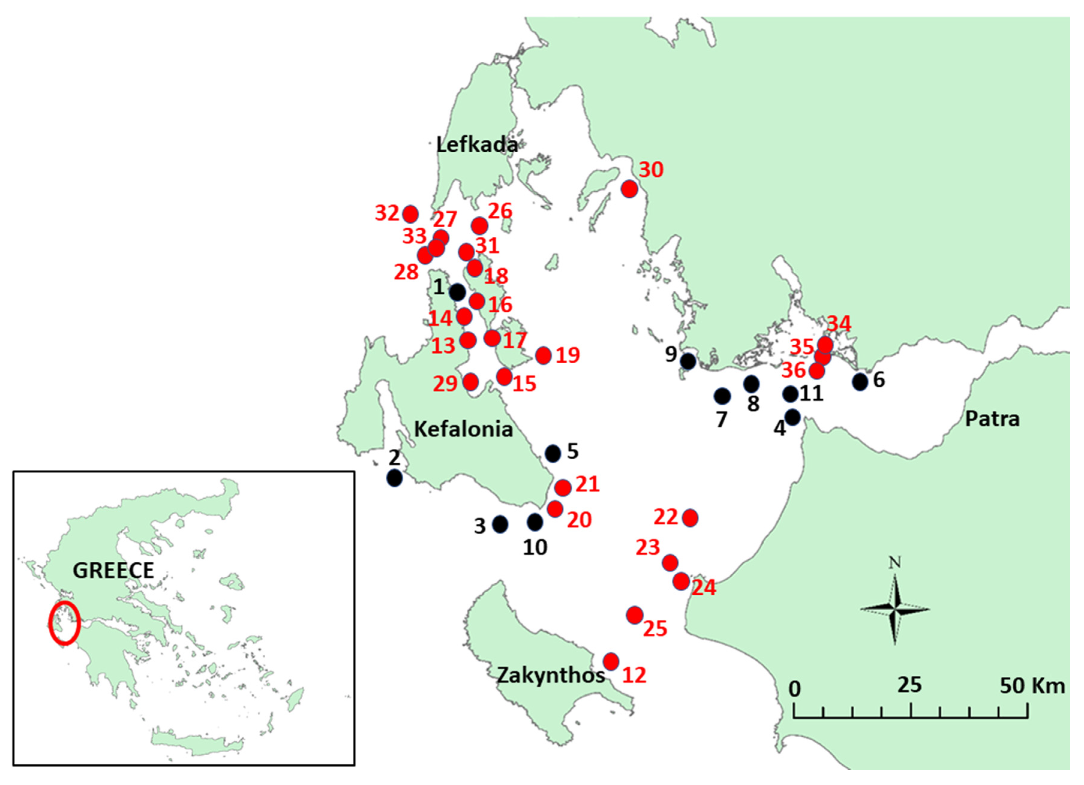
The region of interest (ROI) is presented in
Figure 1. It is the Inner Ionian Sea, which is located in the west part of Greece (see inset picture in
Figure 1). The Inner Ionian Sea is the marine area surrounded by the islands of Lefkada, Kefalonia and Zakynthos, mainland Western Greece and Western Peloponnese. The Inner Ionian Sea is an area that was used by mariners since ancient times and also is the area where two famous battles took place; the battle of Actium and the battle of Lepanto. Therefore, as expected, there are numerous wrecks ranging from antiquity to modern times. The red circles in
Figure 1 indicate the locations of the wrecks. For confidentiality reasons, the wrecks’ locations are approximate and not exact. The black circles indicate the wrecks surveyed by LMGPO.
The wreck numbers in
Figure 1 (associated with the red circles) correspond to the serial numbers in
Table 1.
Table 1 provides a list of the wrecks present in the ROI, and gives basic details for each wreck such as: nationality, type, date lost, dimensions, depth and survey systems.
The list of the wrecks has been constructed based on information gathered from [
28,
29]. The wrecks’ names that have been surveyed by the Laboratory of Marine Geology and Physical Oceanography (LMGPO), Department of Geology, University of Patras, Greece appear in bold letters. The depth of some wrecks in
Table 1 is not known because although the wrecks have been historically recorded their exact location is not known and they have never been identified via marine remote sensing methods.
4. Results—Wrecks Surveyed by the Laboratory of Marine Geology and Physical Oceanography (LMGPO)
This section presents the wrecks surveyed by LMGPO. A total of 11 out of the 36 wrecks in total were surveyed by LMGPO using various acoustic systems (e.g., side scan sonars, multi-beam echo-sounders, sub-bottom profilers). The wrecks are: #1 “Fiskardo”, #2 SS Ardena, #3 HMS Perseus, #4 SS Mars, #5 “Kapros”, #6 SS Svein Jarl, #7 “Pump house”, #8 “Old Iron”, #9 MV Ag. Nektarios, #10 MV Carinthia and #11 HMS Chamois.
4.1. “Fiskardo”
A detailed analysis of the “Fiskardo” shipwreck has been presented in [
30,
31]. In this section only the most important points—relevant to the present work—as analyzed in [
30] are mentioned.
The “Fiskardo” shipwreck was initially detected by a Greek-Norwegian research team [
32] even though they estimated the length of the wreck to be 25 m instead of 30 m. It is located approximately 2 km from the entrance of the Fiskardo embayment at Kefalonia Island at a depth of 61 m. The shipwreck is a Roman period wreck, dated between 1st century BC and 1st century AD. The dating was based on the type of the amphorae found [
31].
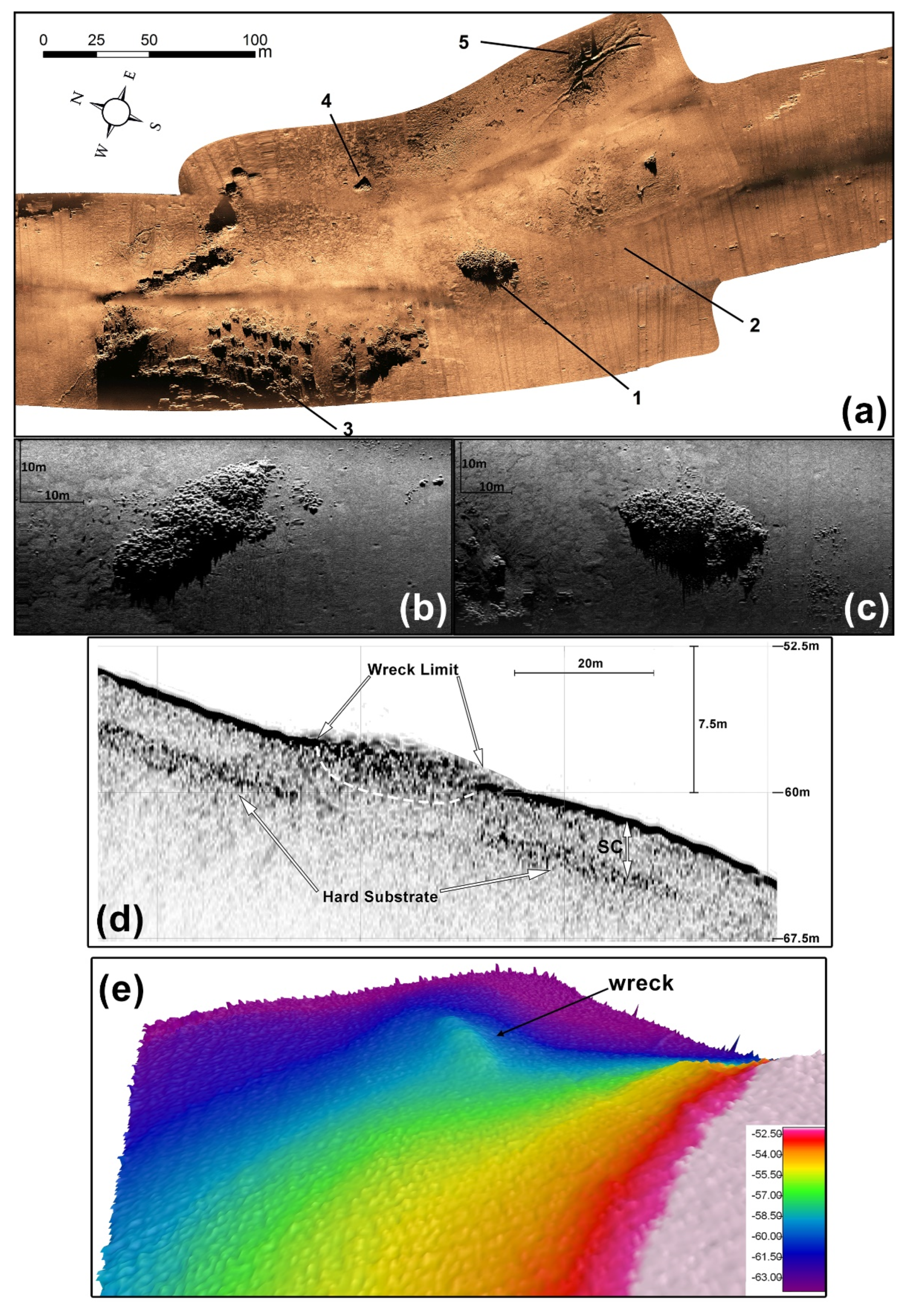
Figure 2a–c presents high-resolution images of the general shipwreck site (
Figure 2a) and the shipwreck (
Figure 2b,c) as depicted from a Klein 3900 side scan sonar operating at 900 kHz. The general shipwreck site (see
Figure 2a) includes: the ancient shipwreck, a target of unknown origin and anchoring marks. The oval shaped pile of the ship’s amphorae is clearly visible in
Figure 2b,c (different views). The shipwreck is lying on a muddy seafloor and her debris field is small and scattered at a distance approximately 8 m around the wreck.
Figure 2d displays the outline of the shipwreck in the vertical plane along the longitudinal axis of the mound, and exhibits the seabed stratigraphy around the shipwreck as acquired with the chirp SBP system. The general stratigraphic sequence around the wreck is interpreted as a 3.5 m thick, homogeneous, muddy sand layer, as indicated by the surficial prolonged (high amplitude) continuous reflector and the absence of internal reflectors, overlying the hard substrate. Over the area that is spatially covered by the cargo, the above described acoustic character in the upper part of the sedimentary layer is interrupted by highly irregular reflectors with an overall elliptical shape. The reflectors inside the ellipsis are highly jagged (denticulate) and are in shades of light and dark grey. This acoustic pattern apparently arises from the reflection of the sound on the amphorae (clayey) surfaces. Therefore, the upper and lower edges of the ellipsis are considered to be the outlines of the wreck. The above presented SSS and chirp SBP data show that the ship’s dimensions would have been about 34 m long and 13 m wide, as the cargo’s measured length and width is 30 and 12 m, respectively, whilst the hull height is about 3.3 m. The dimensions of the shipwreck constitute it as one of the four largest merchant shipwrecks from the abovementioned period that have been found in the Mediterranean to date.
Figure 2e shows the bathymetry of the wreck site as acquired by multi-beam echo-sounder system. The pile of amphorae is presented as an oval shaped protrusion in the bathymetry.
The presence of anchor dragging traces on the seafloor (see
Figure 2a) are probably related to anchoring of yachts and cruise ships at the entrance of the Fiskardo embayment.
4.2. SS Ardena
SS Ardena was built in 1915 at the British shipyard A. McMillan & Son Ltd. in Dumbarton, Scotland under the name HMS Peony. She served as a British navy frigate during World War I. In 1919 she was sold to the London & South Western Railway Company. At Caledon shipyard in Dundee, Scotland she was rebuilt into a passenger ship and she was given the new name SS Ardena. Her last owner was Evangelos Togias, who placed her in service between Piraeus, Chios and Mytilene, Greece from 1932 until 1940. During the Greek-Italian war in 1940, SS Ardena was requisitioned by the Greek Government in order to assist military transportation. In April 1941 she was bombed by the German air force and sustained severe damage. She was then captured and repaired by the German forces and consequently operated under the German Command. More historical information about SS Ardena can be found in [
33].
In 1943, following the decision of the Italian government to negotiate a surrender to the Allies, the German Army tried to disarm the Italians during Operation Achse. In the Greek island of Kefalonia the men of the 33rd Acqui Infantry Division resisted and fought the Germans which resulted in the massacre of the Division. The Italian soldiers who survived the massacre were taken prisoners with the intention to be dispatched in concentration camps in Germany and Poland.
SS Ardena was one of the ships chosen to help with the transportation of the Italian prisoners. She sailed on 28 September 1940 from Argostoli to Patras. However, soon after her departure, she sunk, probably by hitting a mine of an Italian minefield placed in June 1943 by the Italian motor ship BARLETTA. Out of the 840 Italian prisoners held on board SS Ardena, only 120 were saved.
Figure 3a presents a high-resolution side scan image of the shipwreck. The shipwreck is located at 26 to 29 m depth. Her dimensions are: 76.2 × 10.1 × 5.2 m. In
Figure 3a, debris from the wreck is visible. It is mainly located by the sides of the wreck reaching a distance up to 10 m per side. The side scan image in
Figure 3b shows that the debris field is indeed denser closer to the wreck (approximately 10 m distance), but some debris also exist in longer distances resulting at an average debris distance of 40 m. The low reflectivity of the seafloor surrounding the wreck together with the acoustic character on seismic profiles suggest that the seabed consists of soft sediments such as sandy to silty clay.
Figure 3c (main panel) shows the wreck as depicted in a sub-bottom seismic profile. The wreck is lying on the seafloor which consists of 15 m thick (at least) sequence of loose stratified fine-grained sediments. The lowest part of the keel has sunk in the soft sediments of the seafloor and her height compared to the surrounding seafloor is small. This signifies (in combination with
Figure 3a) that only the keel of the ship remains on the seabed. This is in accordance with historical information that part of the shipwreck was salvaged in order to be sold as scrap iron [
33]. Furthermore, the inset images of
Figure 3c show a slight depression formed on the seabed area around the shipwreck due to the deformation of the sediments from the shipwreck loading and/or the erosion of the sediments.
4.3. HMS Perseus
HMS Perseus was a British Parthian class submarine. It was launched on 22 May 1929. The shipyard was the Vickers-Armstrong shipyards in Burrow-in Furness, in the United Kingdom. The dimensions of the submarine were: 88.4 × 9.12 × 4.9 m. It had a range of 8400 nm at 10 knots speed and her maximum operating diving depth was 152 m.
The submarine’s first mission was to participate in patrols in the Chinese sea area. After the beginning of the Second World War, the submarine was integrated in the 1st submarine fleet based in Alexandria, Egypt. The submarine patrolled and participated in military operations in the Eastern Mediterranean.
On 26 November 1941 the submarine received instructions to patrol the sea area from Taranto in Italy up to the Ionian Sea in Greece. The submarine in this mission had a total of 61 passengers. Her crew (59) plus two guests. On 6 December 1941, while the submarine was patrolling in the sea area south of Kefalonia, she hit a mine and sank. John Capes, one of the two non-crew members was the only survivor. He was in a sealed compartment of the submarine. Three more men were alive with him in the same compartment although heavily wounded. All four escaped the submarine using the Davis Submerged Escape Apparatus. Capes was the only one who successfully managed to reach the sea surface and then to swim for six hours to Kefalonia island. The submarine was discovered in 1997, and divers had located the anchor of an Italian “ELIA 145/1925” mine close to the wreck. More historical information about HMS Perseus can be found in [
33,
34].
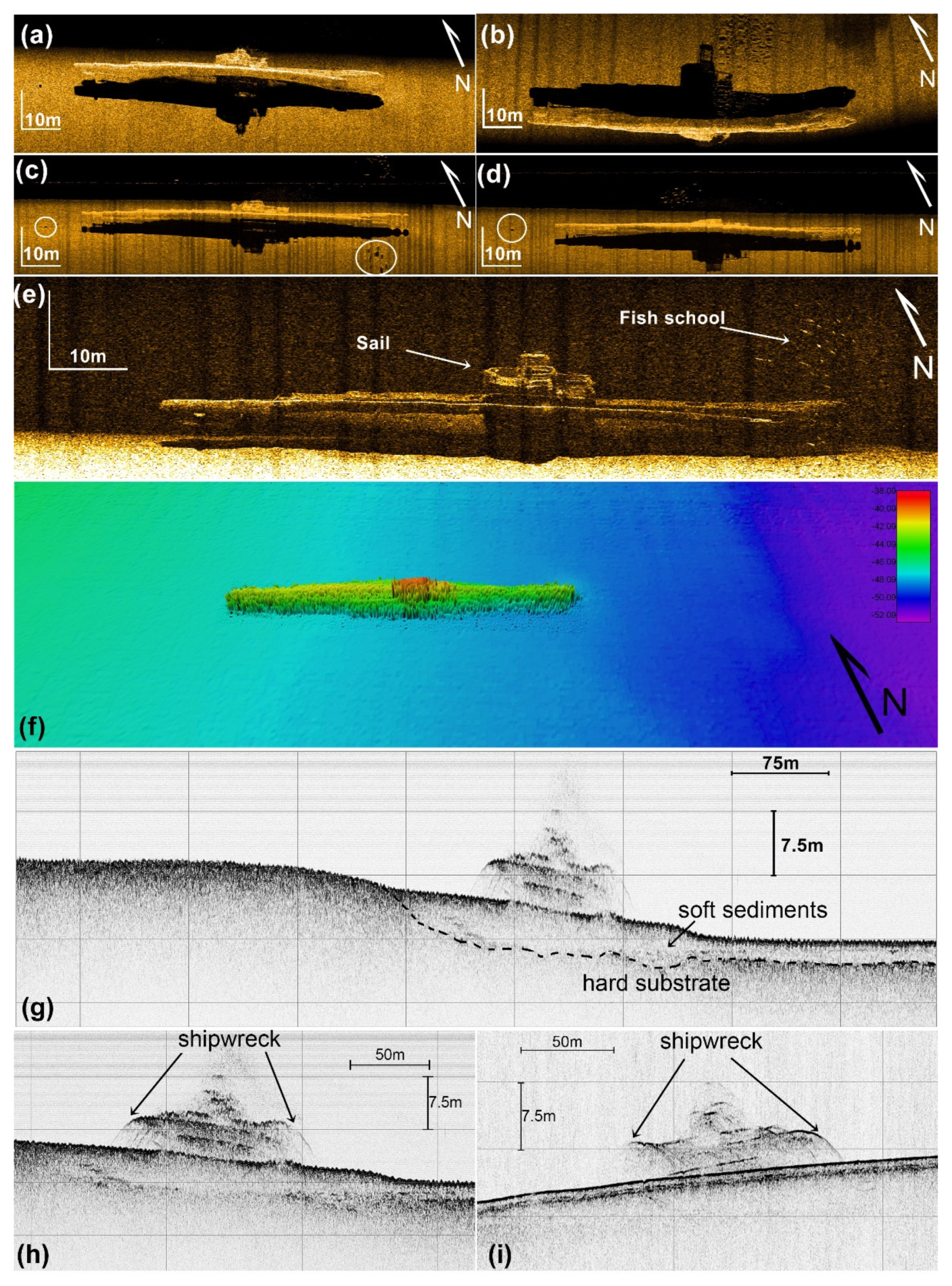
HMS Perseus lies at 52 m water depth.
Figure 4a–e shows side scan sonar images of the submarine taken from different orientations. HMS Perseus lies on the seabed with an 18-degree inclination to starboard. Some unknown targets appear close to the wreck (
Figure 4c,d) at a distance of 10 m. The wreck appears also clearly both in the point cloud representation of the bathymetry logged with multi-beam echo-sounder (
Figure 4f) and the seismic profile from the sub-bottom profiler (
Figure 4g–i).
The high-resolution seismic profile in
Figure 4g shows that the wreck is resting on a thin layer of loose sandy sediments overlying hard substrate. Hard substrate sub cropping the seabed about 75 m away from wreck.
Ground truthing survey using ROV showed that large swathes of fishing nets were covering the wreck.
4.4. SS Mars
SS Mars was a Dutch cargo ship, with dimensions: 84.63 × 11.91 × 5.13 m. She was launched in the Netherlands on 20 October 1925, and her original name was Delamere. Her first owner was an English company (Watson Herbert & Co., Manchester, UK) but in 1926 she was sold to a Dutch company (Koninklijke Nederlandsche Stoomboot Maatschappij (KNSM), Amsterdam, The Netherlands), and then she was renamed Mars.
The last voyage of the ship was on 29 May 1945 when en route from Preveza to Patras she sank after hitting a mine. The mine was part of the Greek military minefield in Araxos. The ship sank near the Pappas cape and she was transporting oil in barrels. Following the collision with the mine, her cargo ignited and the ship was burning all night. She finally sank in the early hours of 30 May. The wreck is located at 50 m depth.
Figure 5a shows a side scan sonar image of the SS Mars wreck site. The ship struck the mine on the starboard side of her bow. The debris field is small and its average distance is 35 m.
Figure 5b is a close up of the SS Mars wreck as depicted by the side scan sonar. The white line, drawn based on the shadow of the image, shows the silhouette of the shipwreck. This silhouette is very similar to a silhouette (blue line) of SS Mars as drawn from a real photo of the ship (
Figure 5c).
Interpretation of the acoustic shadow of the wreck on the side scan sonar record has shown that the fore and aft masts of the ship are missing. Ground truthing survey showed that part of the wreck has been wrapped by a large trawl net.
4.5. “Kapros”
“Kapros” wreck was probably a small wooden boat. The ship carried several dozen artillery missiles 0.70 m long and 150 mm in diameter. These missiles were used in German tactical sliding guns for the coastal defense of sea straits. Most probably she was a small ship carrying German-made ammunition and medical supplies based on the visual inspection by the ROV [
35].
Figure 6a,b show two side scan sonar images acquired at different frequencies (100 and 500 kHz) of the Kapros wreck. The piles of artillery missiles are scattered in an area of approximately 15 × 4 m. The debris field is small and very few artifacts are scattered within 6 m around the wreck. The bathymetry of the wreck site appears in
Figure 6c. The wreck is also barely detectable on the seismic profile as indicated by the overlapping hyperbolic echoes almost tangent to the seafloor (
Figure 6d). The wreck lies on the seafloor which consists of a thick (at least 15 m) sequence of soft stratified sediments (
Figure 6d).
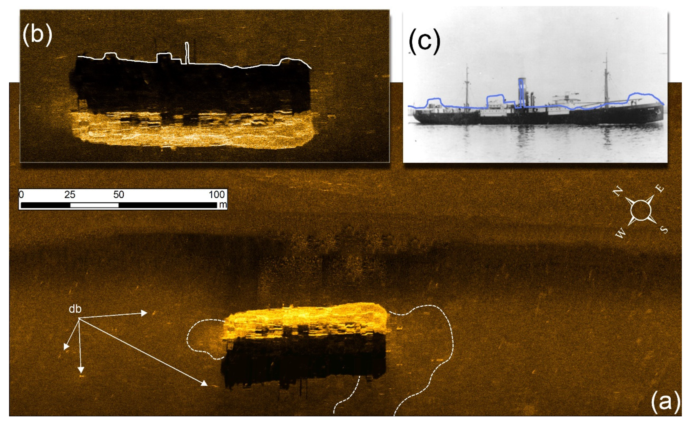
4.6. SS Svein Jarl
SS Svein Jarl was a Norwegian cargo ship, built in 1919 in Trondheim. Her dimensions were: 91.4 × 13.4 × 5.6 m. Her last voyage was from Istanbul to Antwerp. She sunk when she hit in a mine on 16 January 1948, at the mouth of the river Evinos in Aetoloakarnania resulting in the loss of eight of her crew members.
The survey of Svein Jarl from LMGPO was performed about 25 years ago when only analogue side scan sonar records could be produced. Thus, the side scan images in
Figure 7a,b are not of good quality. Nevertheless, when comparing the side scan images to actual photos of the ship (
Figure 7c,d) it is obvious that the side scan images adequately capture the main SS Svein Jarl’s features such as: (1) the bow and (2) the funnel in
Figure 7a; (1) the keel, (2) the propellers, (3) the massive damage on the bow in
Figure 7b. In
Figure 7b, (4) the acoustic shadow and (5) the towfish trackline also appear.
The estimated average debris distance from the wreck is 30 m. Based on ground truthing survey, nets and fishing lines are not present in the shipwreck but her general preservation state is bad. Rich biota has been grown on the shipwreck with most characteristic the yellow sponges at the stern.
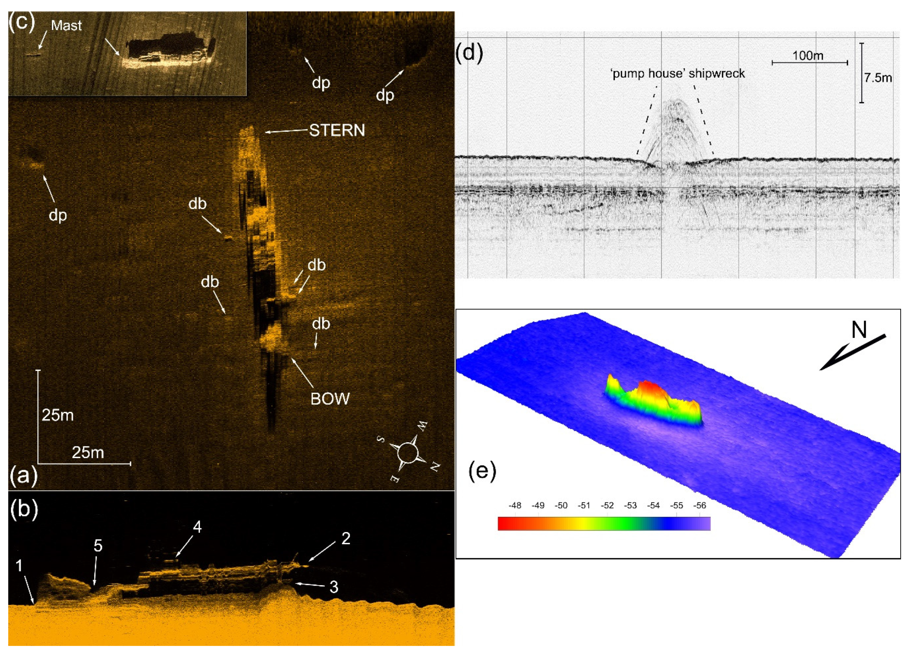
4.7. “Pump House” or SS Christoforos
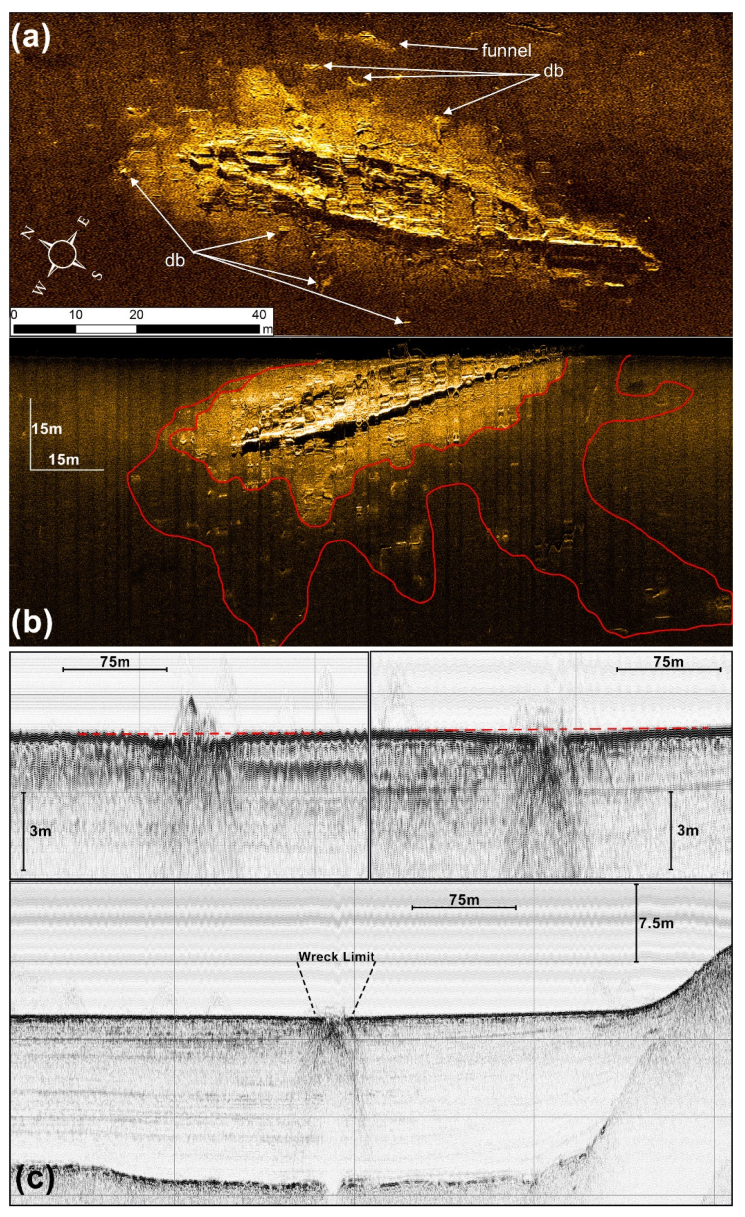
The “Pump house” wreck was initially documented by [
36]. She lies at an average water depth of 54 m. The length of the wreck as measured from the MBES bathymetry is 60 m and her width is 17 m. The “Pump house” wreck is clearly visible on the sonograph of
Figure 8a as a strong reflector. The seafloor sediments in the wreck site are characterized by uniform low backscatter pattern (
Figure 8a) indicating that the wreck has settled on a substrate of uniform, planar homogeneous fine-grained sediments. The wreck stands proud on the seafloor and has a total length of approximately 60 m (as determined from
Figure 8a). The high resolution (500 kHz) sonograph has clearly imaged the main structural components of the wreck including the “blumb” or vertical bow, the bridge, the stern and the propellers (
Figure 8b). This indicates that the shipwreck debris is densely distributed near the core wreckage. This debris field probable results from debris separating from the wreck that sinks almost vertically to the seafloor or by post-sinking man-made activities mainly trawling. Between 50 to 80 m away from the wreck, the side scan sonar survey also clearly imaged a number of small seafloor depressions (
Figure 8a). These crater-like features were interpreted as bomb craters by [
36]. In
Figure 8c the mast of the stern is also visible. The mast is at a distance of approximately 70 m away from its original position (the stern) probably dragged by fishing nets. A small number of artefacts are present at an average distance of 8 m around the wreck.
The “Pump house” wreck is also clearly visible in the sub-bottom profile image in
Figure 8d. A 3.5 kHz sub-bottom profiler was used to acquire sub-bottom profiling data over and around the shipwreck. The wreck appears as elevated multiple hyperbolic echoes and the seafloor sediments around the wreck seem to be slightly deformed. The wreck lies on thick stratified sediments with an existence of enhanced (intense) reflectors, 4 m below the seafloor, indicating coarse grained and/or gas charged sediments.
The wreck is also clearly visible in the bathymetry of the area (
Figure 8e) logged by a multi-beam echo-sounder.
An ROV inspection of the wreck revealed that nets have been tangled around the bridge, suggesting that the wreck has been threatened by destructive bottom fishing activities. The most extensive damage to the ship is on the bow. The sea life growth on the wreck obscure structural details and thus no evidence of an official number or name was found anywhere on the hull.
The interpretation of the acoustic data collected from the “pump house” wreck and the visual inspection in combination with the available shipwreck data of Patras Gulf do not permit clear identification of the wreck. The “Pump house” wreck could be the steamboat merchant “Christoforos”. “Christoforos” was a cargo ship built on 1889 at Lübeck shipyards (Germany) as Kollund and then was renamed to Alide. She sunk on the 1st of February 1921 in heavy weather.
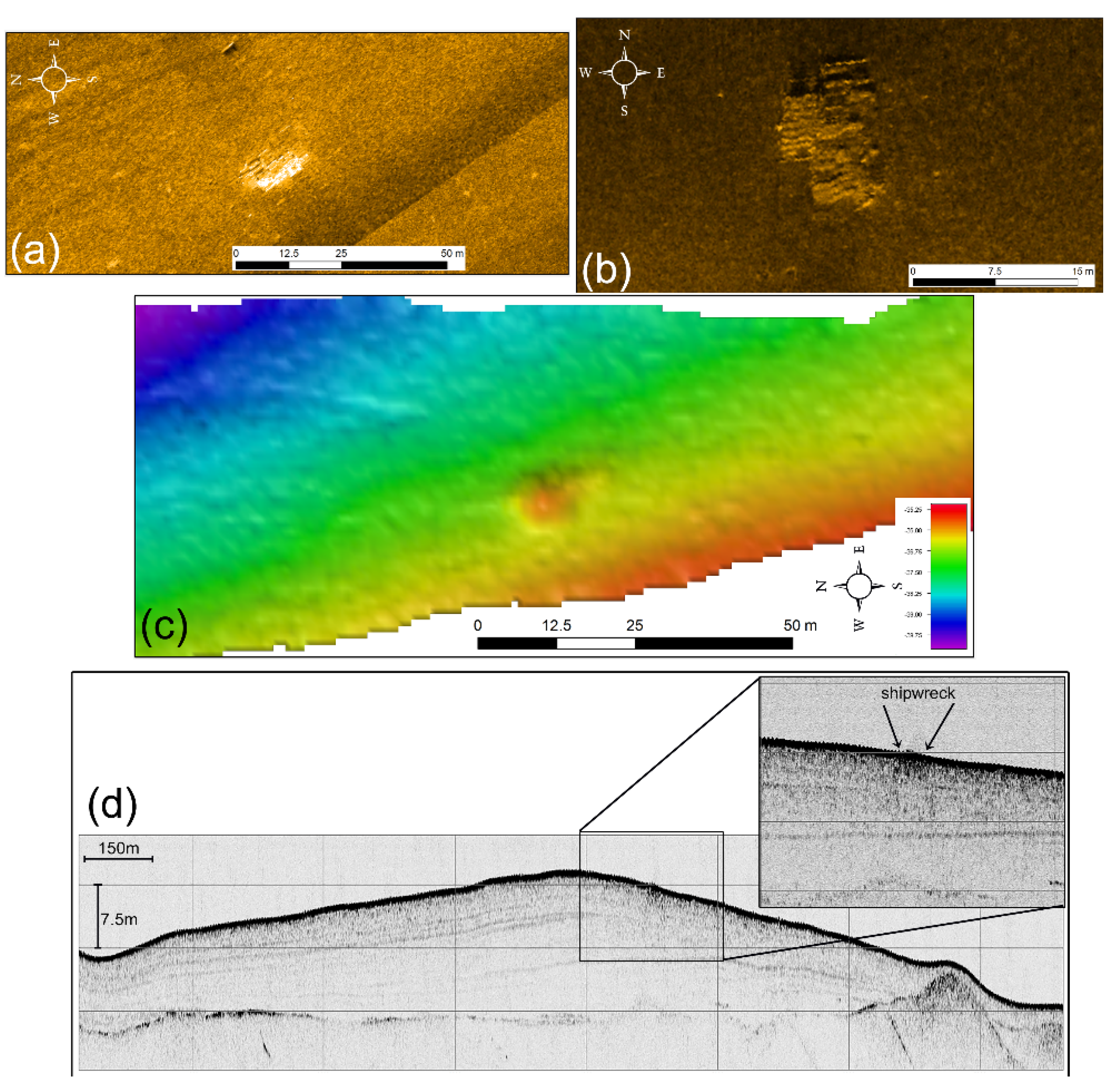
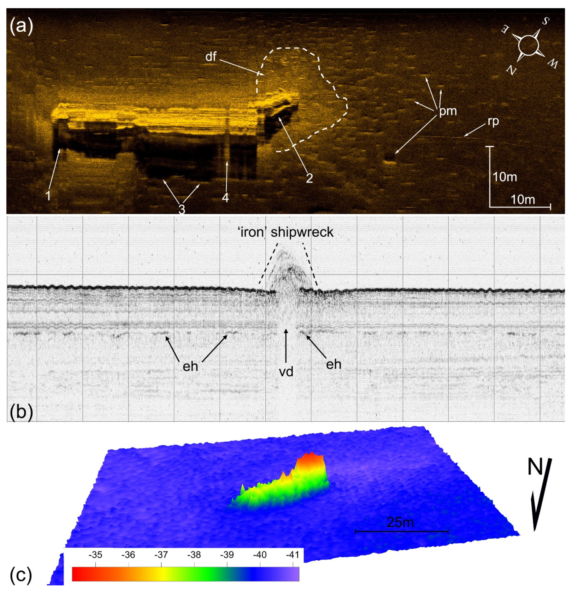
4.8. “Old Iron” or Tanag33
In the same marine survey that the “Pump house” wreck (
Section 4.7) was investigated the presence of one more wreck was revealed: the “Old Iron” wreck. The wreck lies at an average water depth of 41 m and is oriented in a northeast-southwest direction. The length of the wreck as measured from the MBES bathymetry is 31 m and her width is 11 m. A rope tied to the damaged stern is clearly visible on the sonograph (
Figure 9a). The relative position of the acoustic shadow of the rope cast by the sonar indicates that the rope is slightly floating above the seabed. A debris field densely distributed around the damaged stern has been recorded on the sonograph; it is indicated by the large number of small-size high reflectivity objects (
Figure 9a).
Figure 9b illustrates 3.5 kHz profiles acquired over the wreck. Elevated multiple hyperbolic echoes indicate the existence of the wreck. The vertex elevation of the hyperbolic echoes above the seafloor indicates the height of the wreck at this section. The 3.5 kHz profiles show that the wreck is laying on a more or less homogeneous, fine-grained sequence previously described as upper sequence of stratified sediments. A well-developed acoustic void area, seen below the hyperbolic echoes on the 3.5 kHz profiles, has been produced due to the reflection of the sound waves by the very dense and solid body of the wreck (
Figure 9b). As a result, there is no acoustic return below the wreck and thus to acoustic masking of the sub-bottom stratigraphy of the seafloor.
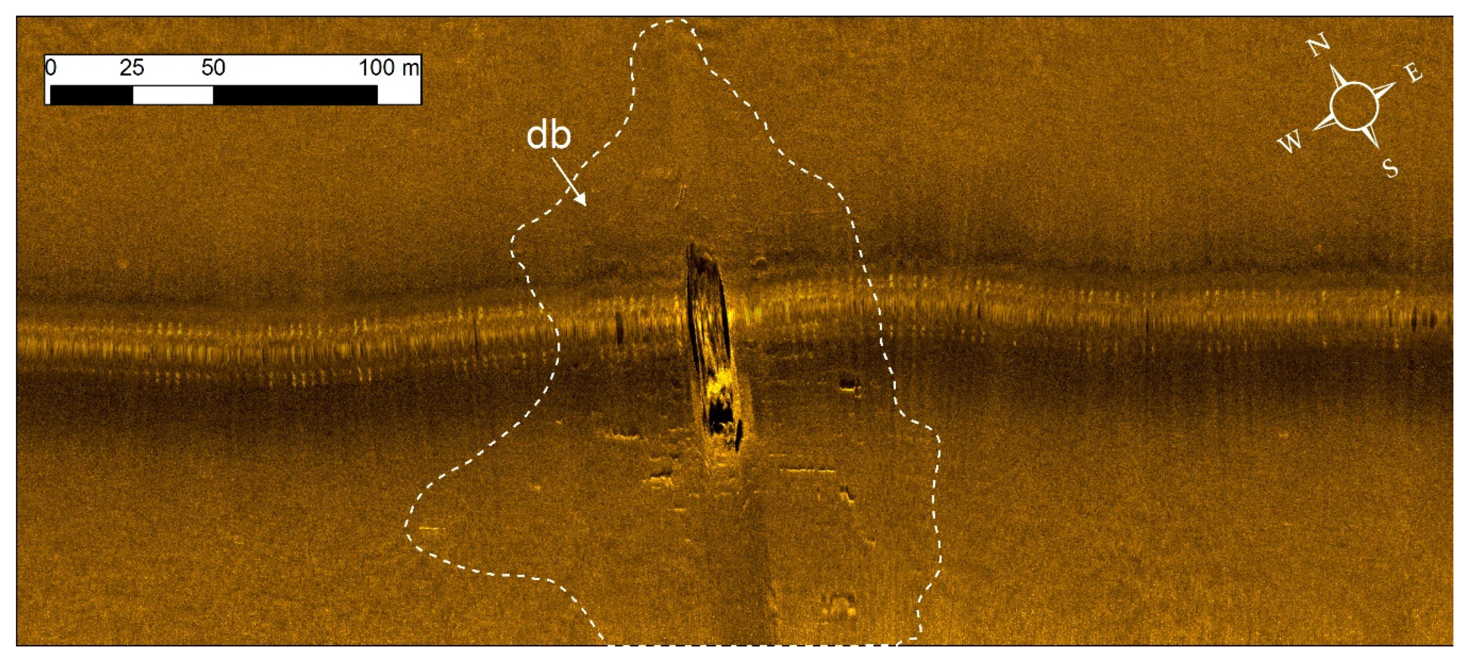
The interpretation of remote sensing data collected at the unidentified wreck, the visual inspection of the wreck and the available shipwreck data base for Patras Gulf suggest that the “old-iron” wreck corresponds to the tugboat Tanag33. On 16th July of 1945, Tanag33 attempted to tow the sailing ship No123 of type Min Caique but entered by mistaken navigation in a minefield and finally sunk.
The most striking finding in the “Old-Iron wreck” site is the small-sized crater-like features which surround the wreckage core (
Figure 9b) at an average distance of 20 m. Since the wreck is located almost right at the center of a cluster of craters it is most likely that the crater-like features are related to the shipwreck. This is not the first-time pockmarks have been formed by the impact of a shipwreck. Reference [
27] mentioned the discovery of an almost intact shipwreck inside a large and shallow pockmark (Witch’s Hole) in North Sea. The findings in the “Old Iron” wreck site probably indicate the explanation given in [
23] that the formation of the pockmark is due to the loading of the landing ship on the soft seafloor and the consequent fluid escape.
Figure 9c shows the bathymetry map of the wreck site as constructed by MBES data. The wreck is clearly visible with her characteristic “tugboat” shape.
4.9. MV Ag. Nektarios
The ship MV Ag. Nektarios sailed from Piraeus on 16 March 1963 to Trieste carrying 646 packages of cotton seeds. The dimensions of the ship were: 45.2 × 8.2 × 2.6 m. When sailing in Patras Gulf, near the island of Oxia, a fire broke out. The steamer Lastovo tried to help “Ag. Nektarios” by towing her to Patras Harbour but she eventually sunk at 41.5 m depth.
Figure 10 shows a side scan image of the wreck. The debris field size is extended and its average length value is 50 m.
The wreck is sitting on the sea bottom with a slight slope to the left. At the front, the large hold of the ship stands out. The bridge is at the back and further down the funnel of the ship.
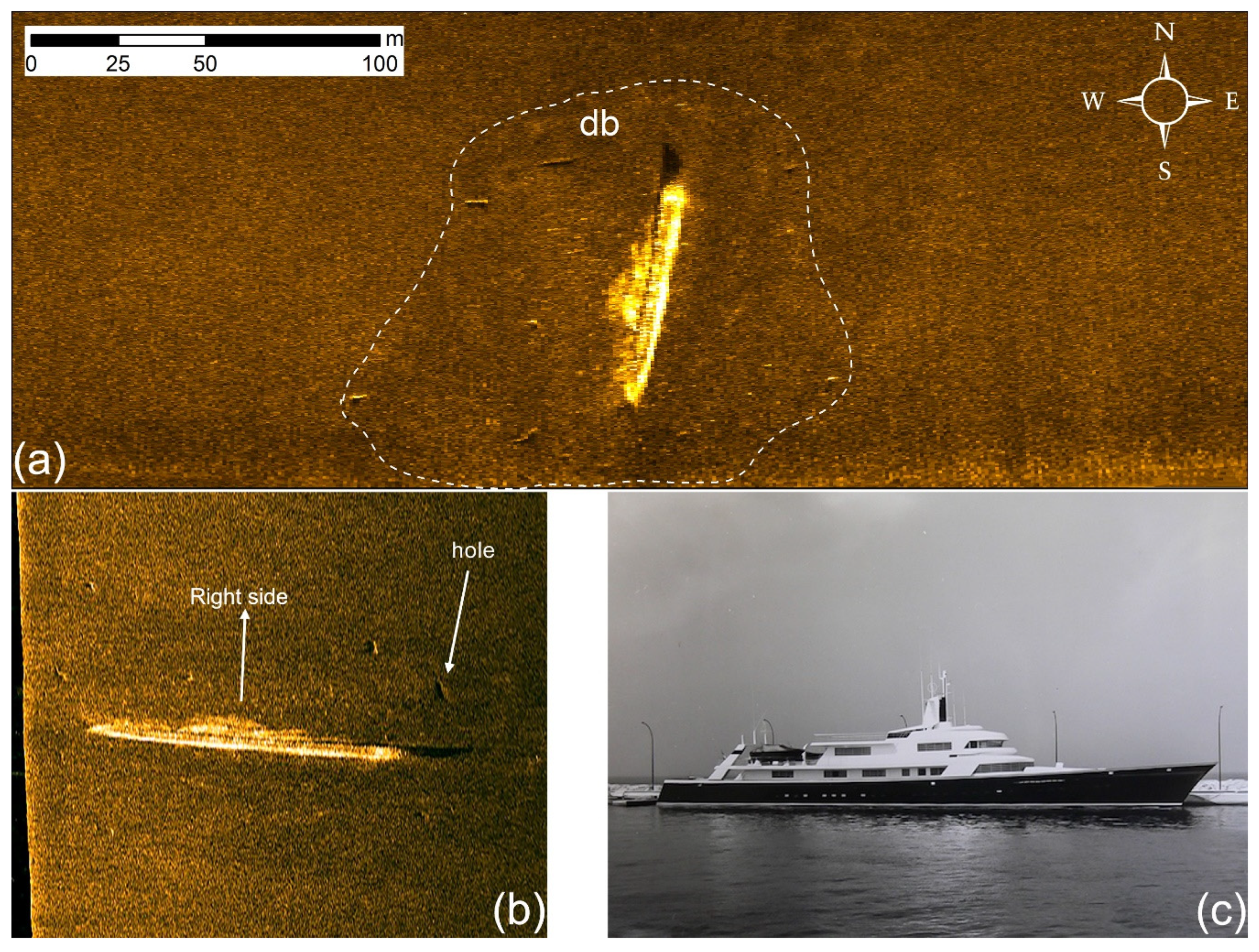
4.10. MV Carinthia
MV Carinthia was a German yacht built by Lurssen shipyards, designed by charismatic designer Jon Bannenberg and owned by industrialist Hemut Horten during 1970′s. The Lurrsen shipyards were usually building warships. Therefore, MV Carinthia looked like a fast warship as it was long and thin (
Figure 11c). Her dimensions were: 68.9 × 9.1 × 2.7 m. She was impressive and very modern yacht for its era. She was referred as the “Titanic of yachts” not only because of its elegancy but also of its fate. She sunk in her first voyage. Carinthia V hit an uncharted reef at Kakava shoals near Kefalonia Island, on 1 November 1971, during heavy weather and sank.
Figure 11 presents a side scan sonar image of the wreck. She lies upside down. The elegant superstructure has been crushed under the weight of the hull but much of it can be seen on the right side. In the inset side scan image one hole, of unknown origin, is present. The debris field is extensive covering a distance of 40 m around MV Carinthia.
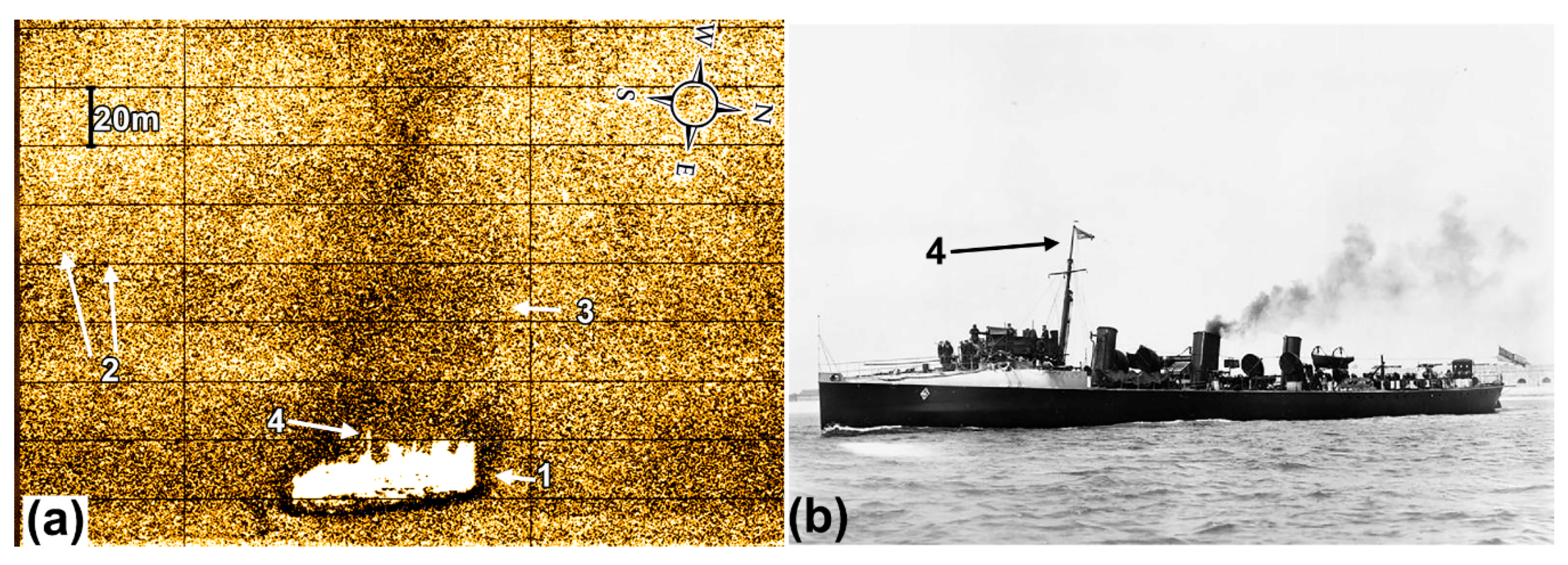
4.11. HMS Chamois
HMS Chamois was a British star class destroyer. She was built in 1896 in the shipyard Palmer’s Shipbuilding & Iron Co Ltd. in Newcastle upon Tyne. Her dimensions were: 65.5 × 6.3 m. The HMS CHAMOIS, which belonged to the Mediterranean fleet, based on the island of Malta, had come to Patras at the time of its sinking, as an accompanying destroyer of the mighty British fleet. One of the innovations that was introduced in this period in the British fleet, was the painting of ships in gray.
She sunk on 26 September 1904, when due to a mechanical failure her propeller blade penetrated the hull plating. According to the ship’s calendar, the HMS CHAMOIS sailed on 26 September 1904 in the Gulf of Patras. North of Cape Papas they tested her machines in full force. At 12:40 water started to enter the rear compartments of the ship. At the same time the engines stopped abruptly, while the ship was shaking violently from vibrations. There was a constant influx of water at the rear of the ship, and an order was given to close the barriers of the boat. Although the order was carried out five minutes later, the sealed door receded, causing water to seep in and flood the ship from the engine to the stern. At that moment, the accompanying destroyers HMS Kangaroo and HMS Exe rushed to the rescue and tied up with the HMS Chamois. At 13:15 the barrels of the engine compartment completely receded and the ship began to sink with the stern until it disappeared below the surface of the sea.
Figure 12a is a side scan sonar image of the shipwreck. The side scan sonar survey took place approximately 15 years ago so the image is of poor quality but two points are worth mentioning: (a) the silhouette of the wreck in the side scan image corresponds nicely to the actual ship (
Figure 12b) and (b) there is an interesting geomorphological feature related to the wreck. In side scan sonar record, the wreck structure is characterized by high-backscatter returns followed by a well-developed acoustic shadow representing the silhouette of the shipwreck. A scour extending from the starboard side of the wreck in an almost E-W (80/260°) orientation, tapering out approximately 150 m from the wreck. The scour is characterized by higher reflectivity (dark tone) compared to the surrounding seafloor sediments. High reflectivity elongated features were also detected running almost parallel to the scour and highlighting the dynamic characteristics of the shipwreck site. The current induced scour, which has been formed almost perpendicular to the long-axis of the wreck, is in accordance with the prevailing currents in the area [
38].
5. Discussion
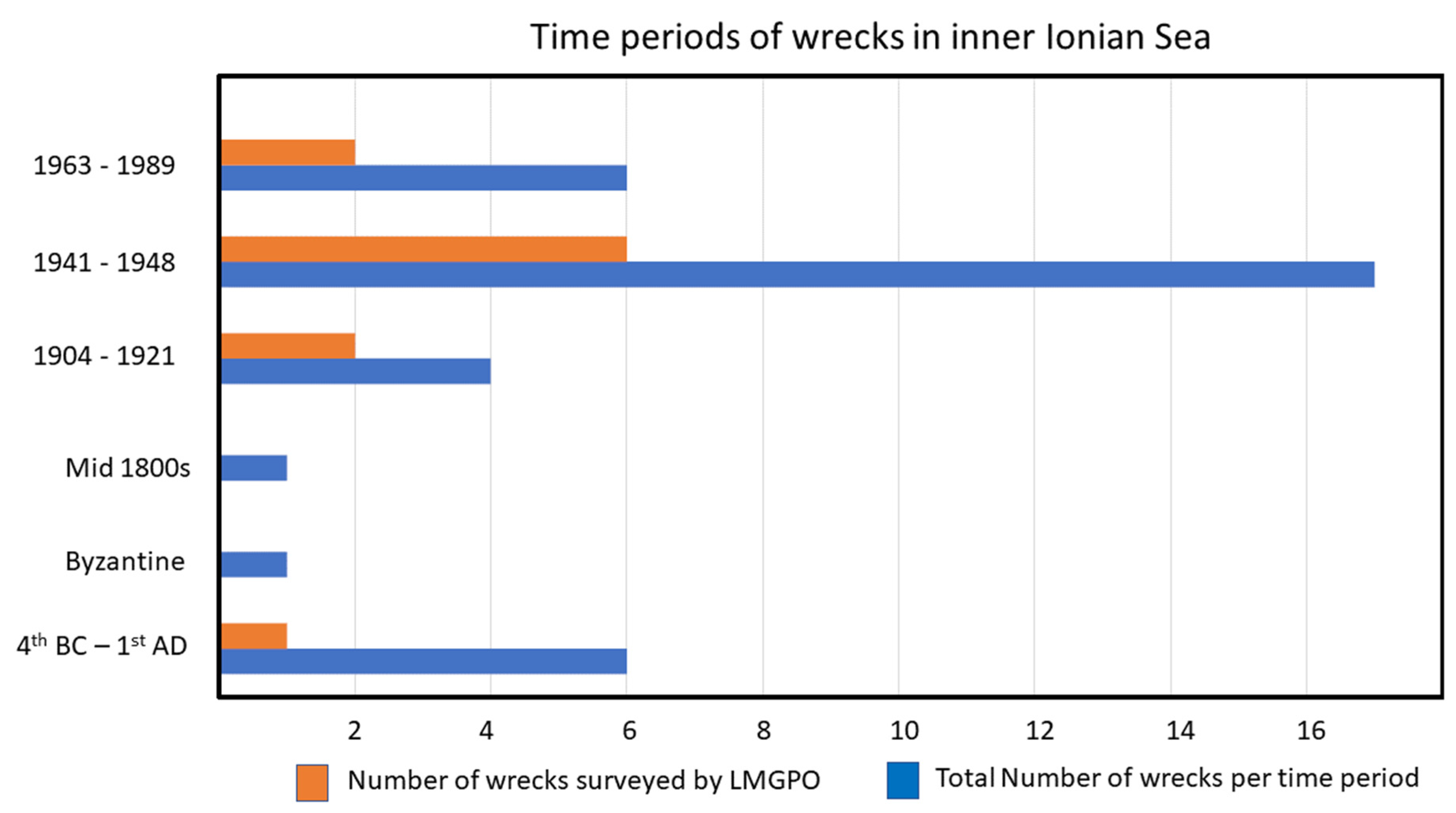
The 36 wrecks present in the inner Ionian Sea cover a time span from the 4th century BC until 1989. In
Figure 13, 35 wrecks have been clustered into six time periods. Anuk (#25 in
Table 1) has been excluded from the analysis as no information about this wreck is available. Almost half of the wrecks (~47%) belong to the period 1941–1948, which is a period related to WWII. The percentage (16%) of ancient wrecks in the area is significant. Also significant is the presence of wrecks from the periods 1904–1921 (11%) and 1963–1989 (16%). This work presents a representative number of wrecks from each one of the above-mentioned time periods; in detail LMGPO has surveyed 16% of the wrecks from 4th BC to 1st AC, 50% of the wrecks from 1904–1921, 35% of the wrecks from 1941–1948 and 16% of the wrecks from 1963–1989.
The wrecks surveyed by LMGPO include one submarine and 10 ships. The ships are of various types: one cargo ship, one small boat, one tugboat, one leisure yacht and one destroyer. Each of these shipwrecks has some significance. “Fiskardo” is one of the four largest merchant shipwrecks from the 1st century AC–1st century AD period that have been found in the Mediterranean to date. SS Ardena has historical value as it serves as a reminder of the horrible fate of the Italian Acqui division. HMS Perseus’ story is related to one of the rare cases when a passenger managed to successfully escape a sunken submarine using the Davis apparatus. SS Mars and SS Svein Jarl were postwar victims of the minefields constructed during WWII. Kapros wreck adds useful historical information on the type of ammunitions and medical supplies used during WWII. “Pump house” wreck and “Old Iron” sites have interesting crater-like features. The “Old Iron” wreck site is extremely important from an environmental point of view, as the pockmarks formation surrounding it is probably due to the loading of the wreck on the seafloor soft sediments that led to fluid discharge. MVAgios Nektarios has the most extensive debris field and MV Carinthia was one of the most pioneering leisure yachts built in her era. Finally, HMS Chamois wreck site has interesting scour formations that have been formed due to the wreck.
The preservation state of each shipwreck is controlled by three dominant environmental factors, (i) physical controls, (ii) biological controls and (iii) chemical/pollution controls [
24]. This paper focuses only on the physical controls on the shipwrecks as they emerged by the interpretation of a variety of marine sensing data; side scan sonar, multi-beam echo-sounding and sub-bottom profiling data. With the use of side scan sonar and multi-beam echo-sounder, large areas of seafloor can be surveyed rapidly, and water turbidity, currents, adverse environmental conditions and shipping traffic can little affect these acoustic remote sensing methods. SSS mainly and MBES secondarily are very effective tools for detecting objects/anomalies on the seafloor which can be considered as potential shipwrecks. Historic, WWI, WWII and modern shipwrecks can be easily detected and recognized even by a large scale marine remote sensing survey based on certain criteria like the size, the shape and geometric characteristics, the reflectivity and the well-developed acoustic shadow [
19,
39]. The detection of an ancient shipwreck, commonly a mound of amphorae cargo, is, without any doubt, a challenging task. In such a case, a small-scale and site-specific survey is needed in order to provide detailed sonar images of the highlighted objects/anomalies in the large-scale survey. The main aim of those detailed surveys is to maximize the separation between potential ancient shipwreck and other seafloor features such as scattered outcropping rocks and coralligenous communities,
Posidonia oceanica and sea-grass prairies, which may have similar acoustic signature in the side scan sonar records [
30,
31].
This work showed that side scan sonar in conjunction with multi-beam echo-sounder do not lead only in the detection of historic and modern shipwrecks, but also provide very important information for the preservation state of the shipwrecks and the shipwreck sites. The small-scale marine remote sensing surveys allowed us to define: (i) huge damages on the hull of the wrecks, (ii) damages and missing parts of the accommodation and deck of the ships (funnels, masts, cranes, etc.) and (iii) the extent of the debris field around the shipwrecks and scattered parts of the ships. Moreover, those acoustic systems showed the existence of scours, and wave and current induced features due to the modifications of water flow regime around the shipwrecks.
Sub-bottom profiling systems have been used successfully in the study of ancient and historical shipwrecks [
31,
40,
41] but have proved to be of limited use when surveying WWI, WWII and modern shipwrecks. On the other hand, those acoustic systems offer important information regarding the modifications of the sediment regimes due to the existence of the shipwreck. In this paper, sub-bottom profilers present valuable data concerning the erosion and the slight deformation of the sediments at the close vicinity of the shipwrecks. Furthermore, those systems together with side scan sonar systems suggest the formation of small crater-like features around the shipwrecks due to their loading on gas charged sediments and consequently the gas seepage.
The extent of the debris field around the shipwrecks can provide information regarding the conditions during the sinking of the ship but also the degree of its disintegration after sinking.
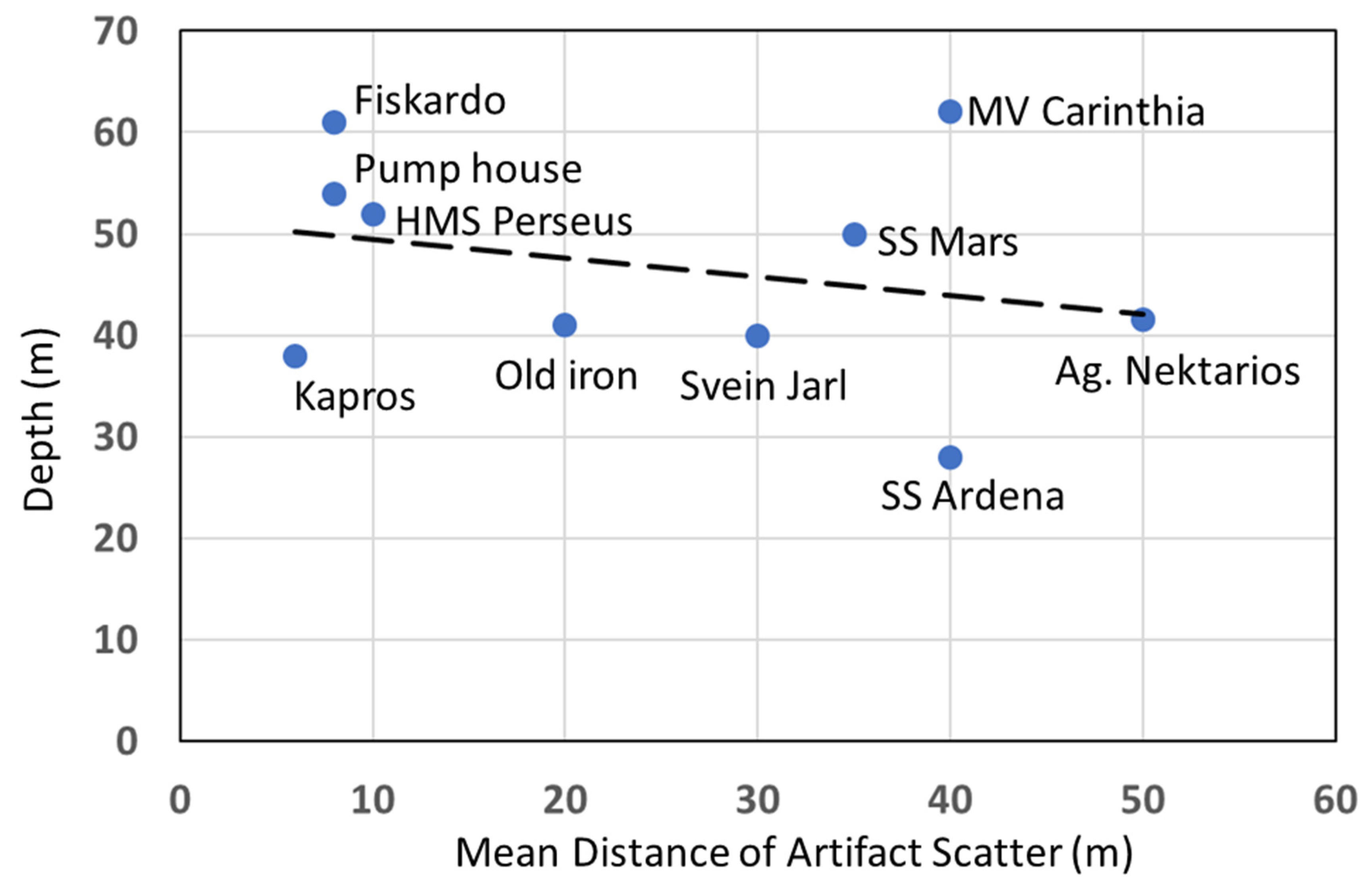
Figure 14 shows the mean site debris distribution for the wreck sites with respect to water depth. HMS Chamois has been excluded because her debris field could not be estimated based on
Figure 12.
The dashed line shows the trend of the data; the mean distance of artifact scatter slightly increases as depth decreases. This, at first sight, contradicts the conclusion from [
42] that the debris area increases proportionately as water depth increases. The opposite trend is due to the fact that the work in this paper and the work in [
37] dealt with different water depth ranges. In [
42], the depth range was from 87 to 1963 m while the depth range of the wrecks in the present work is from 27 to 62 m. Shallow water wrecks are more vulnerable to manmade or environmental activities. Indeed, based on ground truthing surveys and the side scan images of
Section 4, most of the wrecks have suffered damages or are in danger of being damaged by anchors (e.g., “Fiskardo”,
Section 4.1), salvaging (e.g., SS Ardena,
Section 4.2), fishing nets (e.g., HMS Perseus,
Section 4.3) and trawl nets (e.g., SS Mars,
Section 4.4 and “Pump house”,
Section 4.7).
Despite the anthropogenic threats, wave-currents, especially during storm events and in the nearshore zone, also impact the shipwrecks in the studied area. The average annual wave-heights and the mean period of waves in Inner Ionian Sea are 1.1 m and 5.6 s [
43], respectively. Under average wave regime, the waves start to interact with the seafloor when the water-depth is shallower than 28 m. Based on the above, 26 out of 36 shipwrecks are found in water deeper than 28 m and therefore beyond the zone of wave-seafloor interaction.
The remote sensing surveys presented in this paper cannot assess the influence of the biological and chemical/pollution controls on the shipwrecks of Inner Ionian Sea and a well-designed sampling campaign on the shipwrecks and the surrounding seafloor must be carried out. Moreover, 25 out of 36 shipwrecks of Inner Ionian Sea have been fragmentarily explored mainly by divers, largely ignoring their preservation state and the characteristics of the surrounding seafloor. A systematic marine remote sensing survey accompanied with samplings is absolutely necessary for filling the lack of adequate knowledge with regard to the shipwrecks in Inner Ionian Sea.
Each identified shipwreck-site will be systematically surveyed, allowing analysis of the extent of the disintegration of wrecks, the size and distribution of wreck material (debris field) and the morphology of potential associated scour and/or depositional features around wrecks. This data will then be used to define the current preservation state of the wrecks.
Based on the multidisciplinary data that will be acquired from the total number of shipwrecks, an Integrated Shipwreck Preservation and Sustainable Management Plan of the Inner Ionian Sea should be established.
6. Conclusions
The current work created an atlas of the shipwrecks present in the inner Ionian Sea in Greece. Shipwrecks function as time capsule, providing testimonies of the way that people used to trade and perform cultural dialogue during different time periods. Therefore, they provide important historical information. The basic details of 36 wrecks are given, including the name, nationality, dimensions and depth of each wreck. An approximate location is also given (see
Figure 1). A total of 11 out of the 36 wrecks have been surveyed by the Laboratory of Marine Geology and Physical Oceanography (LMGPO), Department of Geology, University of Patras over the last 25 years. The 11 wrecks have been clustered into six different periods. The vast majority of wrecks belongs to the following periods: from 4th Century BC to 1st Century AC, from 1904–1921, from 1941–1948 and from 1963–1989. LMGPO has surveyed a representative number of wrecks from each period. The main findings of the current work are:
All wrecks are significant. Their significance can be based on historical, wreck site formation and design reasons.
Manmade activities (e.g., fishing) take place close to the wreck sites.
Since the wrecks are located in shallow waters, they are extremely vulnerable to manmade activities.
A systematic marine remote sensing and sampling survey is absolutely necessary for the rest unexplored shipwrecks of Inner Ionian Sea.
Therefore, there is an immediate need for an Integrated Shipwreck Preservation and Sustainable Management Plan of the Inner Ionian Sea.
Future work may include the utilization of work similar to the work done in this paper for constructing a virtual museum, that is, an online platform to make accessible some important Greek shipwrecks to the homes of the general public around the world.
Automated remote sensing analysis can also play an important role on optimizing the detection phase of shipwrecks [
44,
45].

 ,
, 


