Review

Facing the Wildfire Spread Risk Challenge: Where Are We Now and Where Are We Going?

1
National Institute of Natural Hazards, Ministry of Emergency Management of China, Beijing 100085, China
2
School of Soil and Water Conservation, Beijing Forestry University, Beijing 100083, China
3
Key Laboratory of Compound and Chained Natural Hazards Dynamics, Ministry of Emergency Management of China, Beijing 100085, China
*
Author to whom correspondence should be addressed.
Fire 2023, 6(6), 228; https://doi.org/10.3390/fire6060228
Submission received: 8 May 2023 / Revised: 2 June 2023 / Accepted: 5 June 2023 / Published: 7 June 2023

Abstract

:
Wildfire is a sudden and highly destructive natural disaster that poses significant challenges in terms of response and rescue efforts. Influenced by factors such as climate, combustible materials, and ignition sources, wildfires have been increasingly occurring worldwide on an annual basis. In recent years, researchers have shown growing interest in studying wildfires, leading to a substantial body of related research. These studies encompass various topics, including wildfire prediction and forecasting, the analysis of spatial and temporal patterns, the assessment of ecological impacts, the simulation of wildfire behavior, the identification of influencing factors, the development of risk assessment models, techniques for managing combustible materials, decision-making technologies for firefighting, and fire-retardant methods. Understanding the factors that affect wildfire spread behavior, employing simulation methods, and conducting risk assessments are vital for effective wildfire prevention, disaster mitigation, and emergency response. Consequently, it is imperative to comprehensively review and explore further research in this field. This article primarily focuses on elucidating and discussing wildfire spread behavior as a key aspect. It summarizes the driving factors of wildfire spread behavior and introduces a wildfire spread behavior simulation software and its main applications based on these factors. Furthermore, it presents the research progress in wildfire risk assessment based on wildfire spread behavior factors and simulation, and provides an overview of various methods used for wildfire risk assessment. Finally, the article proposes several prospects for future research on wildfire spread: strengthening the dynamic monitoring of wildfires and utilizing comprehensive data from multiple sources, further exploring the differential effects of key factors on wildfire spread, investigating differences in driving factors, improving wildfire models in China, developing applicable software, and conducting accurate and scientific assessments of wildfire risks to protect ecological resources.

1. Introduction

Wildfire is a common natural disaster, characterized by the uncontrolled spread and propagation of fire. These wildfires exhibit suddenness, high uncertainty, and significant hazards, resulting in the severe loss of forest resources and damage to natural ecosystems [1]. Notably, in 2020, Australia witnessed the largest recorded forest fire in history, lasting several months and scorching approximately 11.46 million hectares of forest, causing irreparable ecological damage [2,3]. Similarly, in 2019, Muli County, Liangshan Prefecture, Sichuan Province, experienced a forest fire that rapidly spread due to sudden changes in wind direction and intensity, resulting in the tragic loss of 31 lives [4]. In another incident in 2020, a forest fire occurred at the junction of Jingjiu Township and Anha Town, Pijia Mountain Ridge, Xichang City, Liangshan Prefecture. During the rescue operation, 19 people lost their lives as the fire engulfed an area of 3047.78 hectares [5]. These frequent forest fire incidents not only cause substantial economic losses and ecological damage, but also result in severe human casualties. Analysis reveals that the fundamental reason behind these incidents is a lack of an understanding of forest fire spread behavior, leading to inadequate predictions of spread speed, intensity, and extent. Consequently, this has hindered the collection, feedback, and simulation of wildfire spread behavior information, allowing the fires to reach uncontrollable states. Therefore, it is crucial to comprehensively understand the various aspects of wildfire spread behavior, conduct in-depth research on the propagation process, collect and simulate fire behavior information, and assess the impact of environmental factors on fire spread behavior.
In recent years, research on wildfires has primarily focused on wildfire spread behavior, wildfire models [6], wildfire simulation and spatiotemporal distribution [7], wildfire monitoring [8], wildfire hazard risk assessment [9], wildfire impacts on the ecological environment [10], and post-fire ecological restoration [11]. This indicates that understanding and studying the spread of wildfires has been a persistent research focus. The spread behavior of wildfires encompasses the entire dynamic process from ignition to extinguishment [12,13]. The research on wildfire spread began in the 1920s and further development occurred in the 1930s and 1940s. During this period, investigation on the driving factors expanded, delving into the chemical and physical processes of wildfire combustion [14,15]. Wildfire spread models also emerged, with Fons establishing the first mathematical model for fire spread in 1946 [16]. By the 1970s, research on wildfire spread simulation had become increasingly mature, particularly in countries such as Canada, the United States, and Australia [17,18,19]. In the early 1980s, Chinese researcher Wang Zhengfei developed the Wang Zhengfei fire spread model based on the characteristics of forests in China, suitable for most terrains in China with slopes less than 60 degrees [20]. In the 1990s, advancements in computer technology and geographic information technology led to two-dimensional and multi-dimensional wildfire spread simulation [13]. With the development of artificial intelligence in the 21st century, deep learning has emerged as a new research direction. Due to deep learning, the establishment of wildfire spread identification and monitoring is also gradually progressing [21].
Wildfires can cause significant loss of life and property. Wildfire risk assessment enables a scientific and comprehensive evaluation of the potential occurrence and spread risks of wildfires, minimizing the loss of life and property to the greatest extent possible [22]. Wildfire risk assessment can be conducted by simulating the wildfire spread behavior and investigating the factors that influence its spread. This method serves as a scientific and rigorous basis for fire prevention and firefighting efforts by relevant authorities. Conducting risk assessment for wildfires is an important approach to prevent greater loss of life and property during wildfire spread. This article will summarize the domestic methods of fire risk assessment and provide an overview of the current status and development trends.

2. Wildfire Spread Behavior and Risk Assessment System

In order to understand the research system on wildfire spread behavior and risk assessment, we conducted a literature search in the Web of Science (WOS) core database using the keywords “wild fire” and “forest fire”, which resulted in over 20,000 papers. Based on this dataset, we performed a co-occurrence analysis of keywords using VOSviewer, VOSviewer is a software tool for constructing and visualizing bibliometric networks. VOSviewer has been developed by Nees Jan van Eck and Ludo Waltman at Leiden University’s Centre for Science and Technology Studies, The Netherlands. The software version used in this study is VOSviewer_1.6.19 (https://www.vosviewer.com/ (accessed on 7 May 2023)). The resulting analysis network is shown in Figure 1.
In the network graph, the strength of connections in the network graph is determined by the co-occurrence frequency between keywords, visually reflecting the representative keywords and the strength of their connections within the research system. Nodes that belong to the same research cluster are grouped together based on their connection strength. Typically, a cluster of keywords represents a high-frequency research direction.
From Figure 1, it can be observed that the overall keywords related to forest fires/wildfires (referred to as “wildfires” collectively) are divided into four clusters. “Wildfires” are the most central and core term, located in the center of the network graph. In the red cluster on the left side, “severity”, “vegetation”, “fire regime”, and “diversity” are some of the typical keywords. In the literature, this cluster mainly represents research in the field of regional ecology, such as studies related to vegetation after wildfires [23,24]. In the yellow cluster below, “soil”, “rainfall”, “erosion”, and “organic-matter” are some representative keywords. The research direction of this cluster primarily focuses on the chemical changes in the environment (especially soil) after wildfires [25,26,27]. It also includes some concurrent disasters, such as rainfall and debris flows [28,29]. The blue cluster on the right side of the map includes representative keywords such as “impact”, “emission”, “smoke”, and “air pollution.” The research related to these keywords is mostly focused on the atmospheric environment field, such as studies on gas emissions and air pollution caused by fires [30,31,32,33].
The green cluster in the upper-right part of the map includes representative keywords such as “spread”, “risk”, “model”, “behavior”, “climate change”, and “prediction.” The research content associated with these keywords focuses on the study of wildfire spread behavior and risk assessment [34,35,36]. Based on the above content, it is sufficient to demonstrate that the research on wildfire spread behavior and risk assessment is closely related and constitutes important aspects of wildfire research.
Based on this foundation, we extracted the studies related to spread behavior and risk assessment and performed language processing and analysis on their abstract fields. Finally, we visualized the results in a graph using the software. The results are shown in Figure 2. Compared to keyword analysis, the terminology in the abstract fields is slightly less intuitive and requires a more detailed understanding of the related research. The red cluster on the right side consists of core keywords such as “population”, “disturbance”, “species”, and “habitat”. These studies still have an ecological focus and appear in research on spread behavior and risk assessment. Additional terms such as “resistance”, “resilience”, and “survival” are also present [37,38]. We can consider these terms as the manifestation of the impacts caused by wildfire disasters and the significance of disaster prevention and control.
In the left green cluster, it can be divided into two parts for analysis. The lower part includes terms such as “map”, “GIS”, “index”, and “evaluation”, which are commonly used in wildfire risk assessment research. The upper part includes terms such as “prediction” and “simulation”, which are core terms in wildfire spread behavior simulation. With these as the center, the connected green and blue clusters contain terms that can be considered as relevant conditions for simulation, such as “terrain” representing topographical factors, “wind” representing wind force factors, and “fuel condition” representing combustible material conditions.
Furthermore, in the blue cluster of Figure 2, terms such as “height”, “fire intensity”, “experiment”, and “fuel characteristic” provide detailed reflections on fuel conditions, which have a significant impact on wildfire spread behavior [39,40], this indicates that in wildfire spread simulation, the influence of fuel characteristics plays a significant role.
Through a comprehensive analysis of the research system on wildfire spread behavior and risk assessment, this paper will investigate and summarize the following aspects: factors influencing wildfire spread behavior, the applications of wildfire spread behavior simulation, and wildfire risk assessment. The structure of this paper is summarized in Figure 3.

3. Factors Affecting Wildfire Spread Behavior

Wildfire spread is a highly complex combustion process that occurs as a result of multiple factors acting together [41]. Although wildfires exhibit certain patterns, they also display nonlinear and complex characteristics [42]. The driving factors of wildfire spread are generally classified into four categories: meteorological, fuel, topographical, and human factors. These factors collectively influence the behavior of wildfire spread [43]. In this study, we provide detailed explanations based on the four factors that influence wildfire spread.

3.1. Meteorological Factors

In recent years, many forest ecosystems have undergone changes due to the influence of global climate warming [44]. As a result, the occurrence of wildfires has been influenced, with climate change contributing to an increase in both the frequency and intensity of wildfires [45]. Among the meteorological factors, wind speed and wind direction play crucial roles in influencing the spread of wildfires. Wind speed significantly affects the duration of a fire, influencing its spread rate and coverage. Under the combined influence of wind speed and wind direction, the efficiency of heat transfer and the real-time rate of fire spread are directly impacted [46]. Wind accelerates the spread of wildfires through several pathways: (1) Wind can accelerate the drying of fuel, providing sufficient oxygen and dry fuel within the burning area, which serves as the medium for the occurrence of wildfires and accelerates their spread. (2) Unburned fuel within the forest can be ignited more rapidly under the influence of wind, leading to an accelerated spread of wildfires to surrounding areas. Due to it carrying capacity, wind can transport embers generated during the forest burning process to other unburned areas, resulting in new ignition points at the periphery of the fire, this phenomenon is known as spotting. Spotting makes it easier for the wildfire to rapidly expand its range of spread [47]. (3) Altering the spatial distribution pattern of fuel can greatly affect the rate of wildfire spread. For example, increasing fuel density or changing the orientation of flammable materials can have a significant impact on the spread rate of wildfires [48]. Another significant factor that affects wildfires is precipitation [49]. The amount of precipitation on the day of wildfire occurrence and the precipitation over the week are important factors to consider when analyzing the rate of wildfire spread. Increased precipitation leads to higher humidity in the environment and an increase in the moisture content of combustible materials, thus slowing down the rate of wildfire spread [50]. Temperature, another crucial meteorological factor, should also be assessed by considering factors such as daily average temperature and weekly average temperature to understand its influence on wildfire spread [49]. As temperature increases, it decreases the humidity in the environment and rapidly reduces the moisture content of combustible materials, thereby accelerating the rate of wildfire spread. However, some studies have also indicated that extremely high temperatures may hinder the spread of wildfires. This could be due to a threshold relationship between temperature and combustible materials, where the effect of temperature on combustible materials becomes limited once it reaches a critical point [50,51].

3.2. Combustible Factors

Fuel is the material basis for the occurrence and combustion of wildfires [52]. Macroscopically, fuels can be classified into live fuels and dead fuels based on their vitality [53]. Here, live fuels refer to vegetation. As of September 2022, according to the resource inventory data released by the National Forestry and Grassland Administration, China’s forest coverage rate has reached 24.02%, with a forest area of 331 million hectares. China’s grassland area is 392.8 million hectares, accounting for 40.90% of the total land area. Due to variations in geographical locations, vegetation exhibits variations in coverage, area, density, structure, and chemical composition. Consequently, different vegetation types have varying ignition points and burning rates to some extent [54,55]. Research has shown that the occurrence of wildfires follows certain patterns, adhering to typical time patterns determined by environmental conditions and vegetation phenology cycles. The time span can vary from one day to one year [56]. Dead fuel primarily refers to litter or dead vegetation material [57]. Surface litter, with its low density, is the most effective fuel during wildfire combustion. Its impact on fire occurrence is primarily due to the larger gaps between materials, which provide ample oxygen storage as a crucial combustion medium. This accelerates the rate of wildfire spread and expands the range of fire propagation. If the density of surface litter is high, the gaps between materials are smaller, resulting in lower oxygen storage within the litter. This prevents the fire from spreading extensively [58]. As described above, the influence of combustible materials on the spread of wildfires is evident.

3.3. Topography Factors

Basic topographic factors that affect wildfire spread include elevation, slope, and aspect. All three factors are considered static variables [59]. The impact of topography on wildfire spread rate can be observed in the following aspects: (1) Elevation is an important factor influencing wildfire spread. Different ecological conditions exist at different elevations. Higher elevations are associated with lower temperatures, lower humidity, higher relative humidity, and higher plant moisture content, which reduces the likelihood of ignition. In contrast, lower elevations have lower plant moisture content and are more susceptible to burning [60,61]. (2) The impact of slope on wildfires is manifested in its effect on the moisture content of combustible materials. Different slopes have varying durations of rainfall retention, which in turn affects the moisture content of combustible materials. Steeper slopes allow less time for rainfall to stay on the slope, resulting in a quicker drying of combustible materials under the combined influence of temperature and wind after rainfall. This increases the likelihood of fire occurrence. On the other hand, gentle slopes retain a higher percentage of rainfall, which increases the moisture content in combustible materials and reduces the probability and potential for wildfires. Additionally, changes in slope alter the spatial relationship between the burning surface of the wildfire and unburned combustible materials, thereby influencing the spread rate of the wildfire. Generally, uphill and steep slopes exhibit faster spread rates, while downhill and gentle slopes exhibit slower spread rates, although the impact is relatively weaker [62,63]. (3) The impact of aspect on the spread rate of wildfires refers to the influence of solar exposure. Sun-facing slopes (southern or western aspects in the Northern Hemisphere) receive stronger solar radiation, resulting in lower humidity and relatively dry microclimatic conditions. This leads to faster wildfire spread rates on sun-facing slopes. Conversely, shaded slopes (northern or eastern aspects in the Northern Hemisphere) receive weaker and shorter solar radiation, resulting in higher humidity and slower wildfire spread rates compared to sun-facing slopes [64].

3.4. Human Factors

The majority of wildfires currently occurring are caused by human factors [65]. Human factors have both positive and negative impacts on wildfires. On one hand, population density directly influences the occurrence of wildfires. Human activities frequently occur in wildland areas, increasing the likelihood of intentional or accidental ignition sources and, consequently, elevating the risk of wildfire spread. High population density in wildland areas increases the likelihood of such ignition sources [66]. According to data from the National Bureau of Statistics of China, there was a decrease in the number of wildfires from 8859 in 2009 to 2034 in 2016. One of the reasons for this decline is the implementation of the “Forest Fire Prevention Regulations” in 2009, which essentially prohibited outdoor fires [67]. Some studies have shown that the probability of wildfires occurring in economically prosperous areas with high population density but low vegetation coverage and minimal human activities related to vegetation is relatively low [68]. In recent years, with the continuous development of society, there has been an increasing number of human-made facilities in forest areas, such as roads, farmland, water channels, and so on. These facilities directly affect the spread of wildfires. Research has shown that human-made facilities, due to their inherent non-combustible characteristics, significantly reduce the probability of fire occurrence, thereby slowing down the rate and direction of fire spread [69,70].

4. Wildfire Spread Behavior Simulation Application

Computer applications can provide a visually appealing representation of the wildfire spread process. Wildfire spread behavior can be simulated using methods based on the Huygens’ principle or cellular automata simulation. In recent years, with the rapid development of geographic information technology globally, the visualization of wildfire spread has also made significant progress. During this process, numerous simulation software programs have been developed, such as Prometheus in Canada [71], BehavePlus, developed by the United States Forest Service [72], FARSITE [73] and FlmaMap [74], HPC forest fire simulator developed by Argentine scholars [75], Open Source Software Cell2Fire [76] and ForeFire [77]. Therefore, it is inevitable to use appropriate computer system applications for wildfire spread simulation. The following are the main introductions of several widely used applications.

4.1. Simulation Application Based on Huygens’ Principle

Huygens’ principle [78] on the process of wildfire spread is illustrated in Figure 4. Wildfire spread behavior is a complex process involving the interaction of multiple factors. Around the fire scene, each control point is considered as an independent ignition point influenced by external factors such as wind direction, wind speed, and terrain. These factors affect the rate and direction of fire propagation, thereby determining the spread boundary of the fire scene. Typically, the spread boundary of a fire scene presents an elliptical shape, forming an elliptical fire perimeter. Here, we mainly introduce Prometheus, FARSITE, and FlamMap [79]. The input parameters and capabilities of the three software programs are presented in Table 1. In the process of simulating wildfire spread, according to different needs, users can choose by themselves, which is more friendly.

4.1.1. Prometheus

Prometheus was developed in 1999 as a deterministic wildfire growth simulation application. This application integrates the science of wildfires, computer technology, and mathematics. Based on daily meteorological data, it employs computer simulation to model the behavior of wildfire spread. The development of this software is built upon the foundation of the Canadian Wildland Fire Growth System (FBP) [86], which is a simulation software developed based on a typical empirical modeling approach. Prometheus’s spatial input data include slope, aspect, fuel type, weather conditions, etc. Based on the Huygens principle, it uses the Richards wave propagation model to treat the fire perimeter as a collection of independent elliptical fires [71]. Many researchers conduct wildfire spread simulations based on Prometheus. Hagelin [87] et al. applied Prometheus in a wildfire spread simulation in a forest in Sweden, and the simulation results of the forest fire are shown in Figure 5. Figure 5a represents the first simulation conducted by Prometheus based on data from SMHI (2014), while Figure 5b shows the simulation results of Prometheus based on data from both SMHI (2014) and MSB (2015). Due to its user-friendly interface and flexible data input feature, Prometheus provides simulation results that are more in line with the actual wildfire spread, resulting in a better representation of the fire perimeter compared to other software. Zhao [88] et al. applied Prometheus to simulate the Anning “3·29” forest fire in the southwestern forest region, and the simulation results showed some differences compared to FARSITE in terms of fire perimeter, spread rate, and fire line intensity. The reason for these differences may be attributed to the lower latitude of the southwestern region, indicating that Prometheus is more suitable for the northeastern forest region. Braun [89] et al. conducted a simulation assessment of forest fires in a Canadian province and the results were more accurate under peak burning conditions. Based on the above cases, Prometheus has two major advantages. Firstly, its flexibility, user-friendly interface, and the ability to manually modify fire environment inputs. Secondly, its visual results. Prometheus can generate detailed graphical files containing the daily fire spread extent during the simulation period. Therefore, Prometheus is widely used in many countries.

4.1.2. FARSITE

The FARSITE application was developed at the Missoula Fire Sciences Laboratory of the United States Forest Service (US-FS). It is a two-dimensional vector simulation system that integrates thermal physics, combustion science, and experimental theory [73]. FARSITE can simulate the spread of various types of fires, such as surface fires, crown fires, and spotting fires, under different environmental conditions. The simulation results closely resemble the actual fire behavior in the field, making it widely used worldwide [81]. FARSITE requires support from GIS (geographic information system) and RS (remote sensing) for spatial input data. The basic data needed for wildfire spread simulation using FARSITE include landscape element data, weather data, wind field data, and fuel moisture data. Numerous studies have been conducted both domestically and internationally using FARSITE for wildfire spread research. For instance, Xu [90] et al. conducted a simulation of a forest fire in the Inner Mongolia Autonomous Region using FARSITE based on VIIRS fire point data. In each individual simulation process, the consistency between the simulated wildfire spread results and the actual wildfire spread range varies with the duration of the fire spread. Wu [91] explored the spatial distribution characteristics of fire lines in Fenglin Nature Reserve using FARSITE. They applied FARSITE to landscape-scale wildfire risk zoning and classified the severity of forest fire occurrences, providing a reference basis for fire management in Fenglin China. Brakeall [92] conducted simulations of wildfires in Mexico using FARSITE. The simulation results showcased the varying rates of wildfire spread during different months, providing a tool for wildfire management in Mexico. Based on the above cases, the advantages of FARSITE lie in its precise spatial input data and its ability to simulate the process of wildfire occurrence and spread. It is currently considered a more accurate wildfire spread system and has been widely used by many researchers and government agencies.
According to research conducted in a specific area of the Tongass National Forest in Alaska, using data from the US LANDFIRE (LF) Ground Fire dataset and the FARSITE software, we obtained the following results for wildfire spread simulation. In Figure 6, various visual elements of wildfire spread behavior simulation using FARSITE under specific weather fluctuations and random ignition points are depicted. Figure 6a represents the fire perimeter during the spread, Figure 6b shows the fire spread rate, Figure 6c displays the fire intensity during the spread and Figure 6d indicates the time taken for the fire front to reach each node during the spread. By analyzing the simulation results, we can gain a better understanding of wildfire spread patterns and provide valuable guidance for wildfire prevention and control efforts.

4.1.3. FlamMap

FlamMap is a landscape-level application simulation program that integrates fire behavior modeling, fuel management, and map visualization. It is capable of simulating potential fire behavior characteristics, such as spread rate, flame length, and fire intensity. Additionally, it can simulate fire growth and spread as well as conditional burning probability under constant environmental conditions such as weather and fuel moisture. FlamMap combines various aspects of fire analysis, allowing for a comprehensive assessment and prediction of fire behavior in a given landscape [93]. Burning probabilities and fire sizes in FlamMap are calculated using the minimum travel time fire growth algorithm (MTT), which was developed by Finney [94] and has been widely used in spatial fire behavior modeling studies worldwide [95,96]. For example, Yavuz [74] et al. utilized the FlamMap software to simulate wildfire behavior in the western Black Sea region of Turkey. Their study evaluated fire behavior parameters, including fire line intensity and rate of spread, to assess the susceptibility of different tree species within the forest to wildfires. The findings provided valuable insights into the vulnerability of various tree species in the area to fire occurrences. One of the advantages of FlamMap is its suitability for the landscape-level comparison of fuel types. The program’s output combines fuel types with terrain, enabling a visual and accurate determination of the priority of fuel treatments.
Based on the nature of FlamMap software, FlamMap is a fire analysis desktop application, FlamMap was developed by U.S. Forest Service, Rocky Mountain Research Station, Fire, Fuel, and Smoke Science Program.The software version used in this study is FlamMap 6 Version 6.1 (https://www.firelab.org/project/flammap (accessed on 7 May 2023)).which is suitable for fuel horizontal comparisons, we used the MTT algorithm to simulate the spread and behavior of wildfires. We selected a specific area in Tongass National Forest, Alaska, and provided specific baseline parameter settings, such as fuel moisture, ignition point, wind speed and wind direction. We then simulated the visualized maps of wildfire spread behavior after changing a specific fuel type. As shown in Figure 7, the fuel types were referenced according to Scott’s classification [97]. Figure 7a shows the visualized map of fire line intensity during wildfire spread under the original fuel type. Figure 7b shows the fire line intensity map during wildfire spread after changing the Timber Litter (TL2) type to Grass (GR2). By comparing the two, significant changes in wildfire spread can be observed. These results visually demonstrate the impact of fuel modification on wildfire spread, providing scientific support for practical applications.

4.2. Cellular Automata-Based Simulation Modeling

Cellular automaton (CA) is a dynamic system that can simulate spatial and temporal characteristics. In the process of fire spread, fuel and terrain conditions are assumed to be uniform within each cell, and fire propagates on a grid-based on each cell. CA is a grid-based dynamic model that follows certain causal relationships [98]. CA is easily integrated with digital data from geographic information systems (GIS) or other sources to generate applications for specific environments. Table 2 provides specific information on applications based on the CA framework. Sullivan and Knight [99] et al. developed a hybrid two-dimensional meta-automata model system with convective wind interactions, whose spread application is based on a meta-automata spread approach and a semi-physical model of thermal convection to simulate wildfire spread boundaries during wildfire occurrence. The application used in Mutthulakshmi’s [100] study was based on the CA framework, which was improved and optimized to simulate wildfire spread, analyzing the factors that influence fire spread and determining which factors play a key role in the spread of wildfires. Rui [101] constructed an improved model system that couples a meta-cellular automaton with an existing wildfire model. The system considered the effect of time step on simulation accuracy to provide optimal time step values with high temporal and spatial consistency. Xu [102] proposed a new fire spread modeling approach, LSSVM-CA, which combines the least squares support vector machine (LSSVM) with a three-dimensional wildfire CA framework and considers the effect of adjacent winds on fire spread patterns for analysis. To summarize the cases, the combination of wildfire spread visualization and the application system developed by meta-automata has become a popular and viable choice in simulating wildfire spread behavior.

5. Wildfire Behavior Risk Assessment

Wildfire risk assessment involves the scientific and comprehensive evaluation of the potential occurrence and spread risks of wildfires [22]. To conduct wildfire risk assessment, it is necessary to establish a wildfire propagation model and simulate fire behavior to gain a deeper understanding of the characteristics of fire spread at various stages. Wildfire risk assessment can be conducted by evaluating factors such as fire occurrence probability, spread velocity, and extent. This allows for early identification of high-risk areas and implementation of warning and prevention measures. Only through a scientific evaluation of fire risk can relevant authorities make informed decisions regarding fire prevention, suppression, and assessment of disaster situations and damages.

5.1. Overview of Wildfire Risk Assessment

Through literature research and summarization, various methods of wildfire behavior risk assessment have been identified, including wildfire risk assessment based on wildfire forecasting [103], fire risk assessment based on the establishment of a risk index [104,105], fire risk assessment based on information diffusion theory [106,107], integrated fire risk assessment based on “3S” technology [108,109], deep learning-based fire risk assessment [110,111], fire risk assessment based on factors influencing wildfire spread behavior, and fire risk assessment based on wildfire spread behavior simulation, as presented in Table 3.
Wildfire risk assessment methods based on wildfire prediction have a higher accuracy and are greatly influenced by weather forecast factors. They are suitable for a medium-scale range. On the other hand, the method of establishing risk indices for wildfire risk assessment considers multiple factors and is more suitable for macro-level applications. The information diffusion theory-based method is better suited for analyzing small samples due to its inherent characteristics. Integrated wildfire risk assessment using “3S” technology and deep learning-based wildfire risk assessment have been widely applied in recent years due to rapid advancements in scientific and technological capabilities. However, they require strict data accuracy. The accuracy of wildfire risk assessment methods based on factors influencing wildfire behavior and the behavior simulation of wildfire spread is higher. In the preceding sections of this article, we have extensively discussed the driving factors influencing wildfire spread behavior and conducted in-depth simulations. Therefore, in the following sections, we will provide detailed discussions on wildfire risk assessment based on these influencing factors and behavior-based wildfire risk assessment.
Each of the mentioned assessment methods has its own advantages and limitations. However, the ultimate goal of wildfire risk assessment is to provide a scientific and systematic evaluation of wildfire spread risks. This includes early warning, resource allocation, monitoring, emergency response, and decision support, all aimed at minimizing the potential harm of wildfires to people and property.

5.2. Wildfire Risk Assessment Based on Wildfire Spread Behavior

5.2.1. Wildfire Risk Assessment Based on Influencing Factors

From the previous discussion, it is evident that wildfire risk assessment aims to comprehensively consider various factors such as weather, topography, fuel, and human factors. Predicting and evaluating the primary driving factors during wildfire spread provides a scientific basis for dynamic fire management and prevention. Through an in-depth study of fire-driving factors, it is possible to understand the potential paths, speed, and intensity of fire propagation. This understanding enables resource allocation, firefighting strategies, early warning systems, and emergency evacuation measures to minimize potential harm to individuals, property, and the environment, safeguarding both the ecological environment and human safety. Xu [112] et al. created a wildfire risk map for the Baihe Forestry Bureau by selecting driving factors that influence fire occurrence, such as topography, human settlements, land use, and vegetation. They conducted a value analysis using GIS technology, and the resulting output, as shown in Figure 8, closely matches the actual locations affected by fires. However, it is important to note that the assessment results may possess a subjective element. Zheng et al. [113] provided recommendations for wildfire risk assessment in Heilongjiang. They conducted on-site investigations and completed a “Forest Fire Risk Assessment Form”. Objective factors influencing wildfire spread (such as fuel load, topography, lightning fires, etc.) and human factors (such as planned burning, ceremonial fires, firefighting team equipment, etc.) were selected based on counting and benchmarking rules. Risk assessment work was carried out accordingly, and appropriate recommendations were provided based on the assessment results. One disadvantage of this assessment method is that human subjective interpretation can have a significant impact on the evaluation results, introducing certain biases. However, understanding the driving factors of wildfires during the wildfire spread process and monitoring the dynamic behavior of wildfires are crucial aspects of wildfire management.

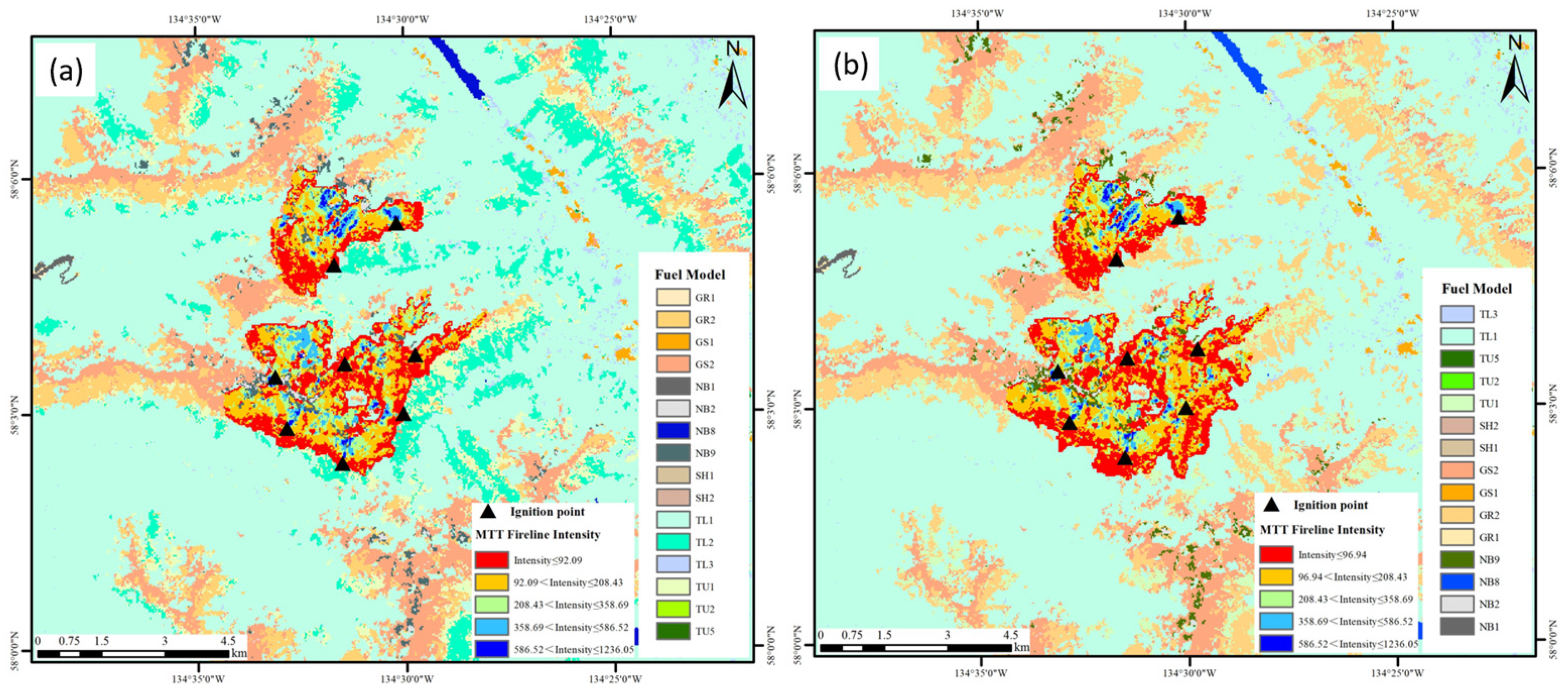
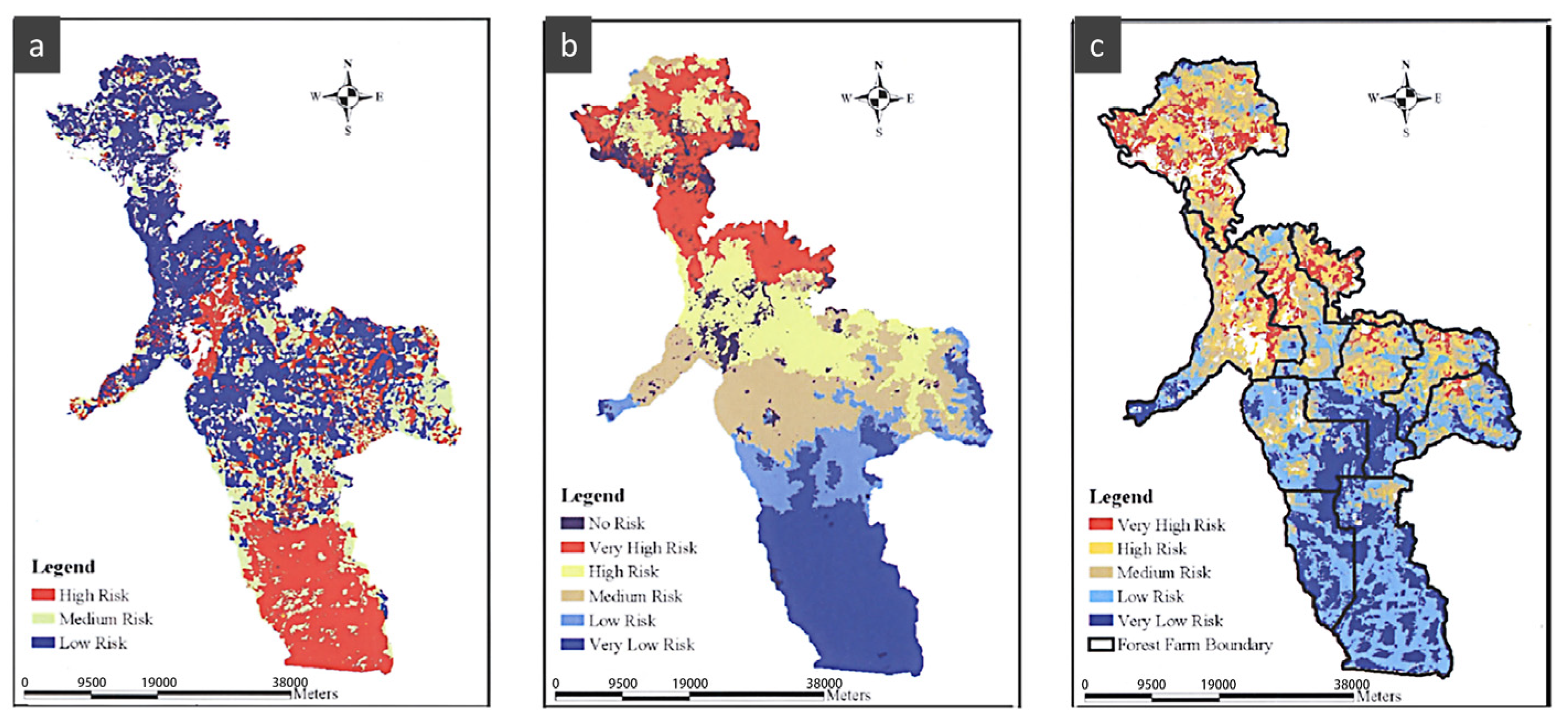
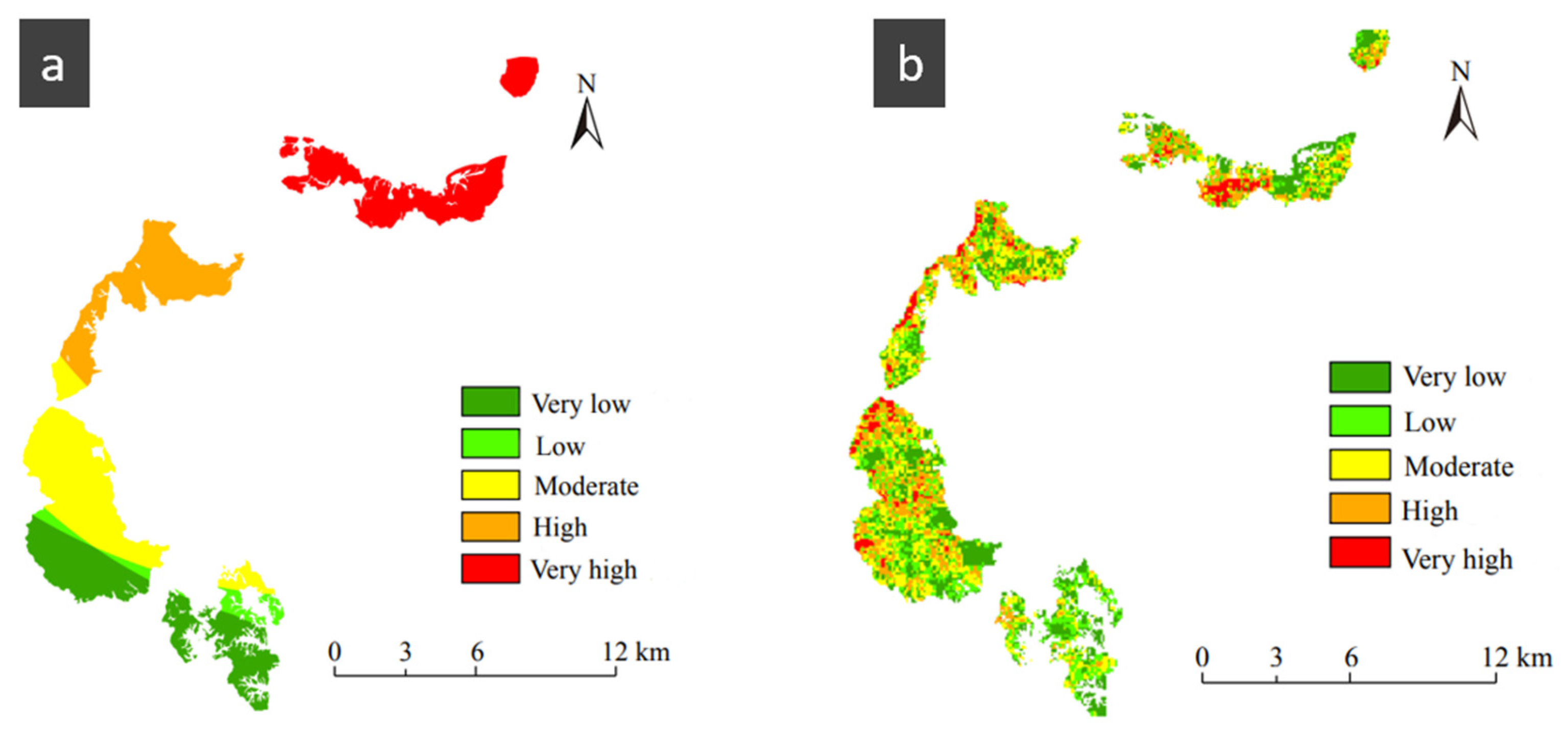
5.2.2. Behavioral Simulation-Based Wildfire Risk Assessment

Wildfire risk assessment based on historical fire ignition data combined with fire spread influencing factors or fire spread models is a highly accurate and precise method. By simulating wildfire spread behavior, it is possible to predict the speed, direction, and extent of fire propagation, thus quantitatively assessing the level of wildfire risk. Carmel et al. [114] created a distribution map of wildfires in Mount Carmel, Israel, covering 20 years of historical fire data. They generated Monte Carlo simulations for fire spread based on these data and used FARSITE software (FlamMap includes FARSITE, currently does not support separate download) to simulate fire spread for 500 fire points. This approach provided a long-term strategic plan for fire prevention activities in the area. Zong [115] et al. conducted an analysis of fire spread behavior elements in the forest area belonging to the Subtropical Forestry Experimental Center using the fire simulation software Burn-P3. The analysis included factors such as burning probability and spread rate to assess the risk of wildfire spread. Figure 9 shows the results, where Figure 9a represents the area’s exposure level and Figure 9b depicts the forest fire risk map for the area. The research findings provide scientific management recommendations for various forest types. Massada et al. [116] conducted an analysis and study on wildfires in the northwestern region of Wisconsin. They used FARSITE and MTT to simulate the spread of wildfires in experimental simulations. By evaluating the fire risk in different stages based on the simulation results, the study helped reduce the risk of wildfire occurrence and provided comprehensive and scientific guidance for improving the wildfire prevention and control system in the northwestern region of Wisconsin. The advantages of risk assessment based on wildfire spread behavior simulation are that it takes into account the combined effects of multiple driving factors on fire spread and the input data are more accurate. However, this type of assessment requires many parameters and complex data, and some commonly used wildfire spread simulation software have strict requirements for combustibles.

6. Conclusions and Prospects

In recent years, there has been significant progress in the research of wildfire spread behavior. This paper aims to systematically construct a wildfire spread behavior and risk assessment system based on a dataset of 20,000 papers from the Web of Science (WOS) core database. Through an analysis using VOSviewer (V_1.6.19), it is evident that the research on wildfire spread behavior and risk assessment is closely related and represents important components of the wildfire research field. Based on this foundation, the paper summarizes the impacts of meteorological, topographical, combustible, and human factors on wildfire spread behavior. Additionally, it provides a brief description of several commonly used software applications for simulating fire spread processes and discusses the selection of data for simulation using this software. Moreover, the paper provides a comprehensive overview of various methods for wildfire spread behavior risk assessment, with a particular focus on two risk assessment methods based on wildfire spread behavior influencing factors and simulation.
This study serves as a valuable reference for wildfire prevention and emergency decision-making. However, it acknowledges the need for further in-depth research in certain areas. The paper suggests that future research should concentrate on the dynamic monitoring of wildfire spread behavior, a quantitative analysis of wildfire spread behavior and driving factors, the development of wildfire spread behavior simulation algorithms and software, as well as wildfire spread behavior risk assessment. The following are our key conclusions:
(1)
Enhancing research on the dynamic monitoring of wildfire spread behavior is crucial. The key to firefighting is early detection and early resolution. Dynamic monitoring serves as an important foundation for emergency management when wildfires are approaching or beginning to start, as it can minimize disaster losses and enhance disaster prevention and mitigation capabilities. The data required for wildfire monitoring encompass various aspects, such as fire front position, fire extent, fire tracking, and other monitoring measures. The accuracy of these data directly impacts the effectiveness of monitoring efforts and the ability to reduce losses. In recent years, China has launched multiple domestically developed high-resolution remote sensing satellites and Beidou Navigation Satellites. However, each satellite has its own strengths and limitations. Therefore, it is imperative to explore methods for integrating and utilizing multi-source satellite data in a complementary and coordinated manner to maximize practical applications. Furthermore, it is essential to address the timely, efficient, and accurate communication of monitoring information, particularly during abnormal weather conditions. Developing effective communication channels and systems to disseminate monitoring information to relevant stakeholders is crucial for facilitating prompt decision-making and response actions.
(2)
The study of driving factors of wildfires has gained significant attention, and it is crucial to identify and quantify the relationship between wildfires and these driving factors for global wildfire research. Wildfire spread behavior exhibits various characteristics, such as the extent and intensity of fire spread. It is also worth researching and discussing which specific driving factors have a greater impact on these characteristics. Additionally, it is worth exploring whether the driving factors at regional and local scales during wildfire spread exhibit uniformity or significant differences, which is another topic worthy of discussion.
(3)
In the current context, due to spatial heterogeneity, most wildfire spread modeling software focuses on specific scenarios and environments, making them less applicable to a wide range of environments and unsuitable for broad-scale implementation. Therefore, in future research, it is important to prioritize the comprehensiveness of the models. For example, incorporating wildfire visualization into wildfire spread models can be explored. On the other hand, since wildfire spread models originated from overseas, many of the parameters in these models are not applicable to the forest conditions in China. In recent years, thanks to the continuous efforts of domestic experts and scholars, wildfire spread models in China have been improving and maturing. In future research, it is necessary to gradually establish accurate and mature wildfire spread models specific to China and develop application software that simulates wildfire spread behavior suitable for China’s context.
(4)
For wildfire risk assessment, each assessment method has its own applicable environment. The introduction of scientific remote sensing technology and the concepts and techniques of geographic information systems (GIS) has led to significant progress in wildfire spatial data processing and analysis of wildfire spread. These advancements have further facilitated the assessment of wildfire risk at the landscape scale. In future research, the primary focus should be on utilizing 3S technology (remote sensing, GIS, and GPS) and deep learning techniques, supplemented by other methods, to achieve a comprehensive and accurate assessment of wildfire spread. This approach will result in more intuitive and scientifically sound outcomes. In summary, conducting precise and scientific wildfire risk assessments can effectively guide relevant departments in implementing sound fire prevention measures, thereby reducing the occurrence of large-scale wildfires and protecting various resources and ecosystems more effectively.

Author Contributions

Methodology, J.S.; software, J.S. and Y.H.; validation, W.Q. and C.X.; writing—original draft preparation, J.S.; writing—review and editing, W.Q., C.X. and W.Y. All authors have read and agreed to the published version of the manuscript.

Funding

This study was supported by the State Administration of Science, Technology and Industry for National Defence, PRC (No. KJSP2020020303), the National Natural Science Foundation of China (42077259) and the National Key Research and Development Program of China (2021YFB3901205).

Institutional Review Board Statement

Not applicable.

Informed Consent Statement

Not applicable.

Data Availability Statement

Forest fire simulation based on FlamMap and FARSITE. The data from https://landfire.gov/ (accessed on 26 January 2022).

Conflicts of Interest

The authors declare no conflict of interest.

References

  1. Arif, M.; Alghamdi, K.; Sahel, S.; Alosaimi, S.; Alsahaft, M.; Alharthi, M.; Arif, M. Role of machine learning algorithms in forest fire management: A literature review. J. Rob. Autom. 2021, 5, 212–226. [Google Scholar]
  2. Boer, M.M.; Resco de Dios, V.; Bradstock, R.A. Unprecedented burn area of Australian mega forest fires. Nat. Clim. Chang. 2020, 10, 171–172. [Google Scholar] [CrossRef]
  3. Finney, M.A. The challenge of quantitative risk analysis for wildland fire. For. Ecol. Manag. 2005, 211, 97–108. [Google Scholar] [CrossRef]
  4. Du, J.; Wang, K.; Cui, B. Attribution of the extreme drought-related risk of wildfires in spring 2019 over southwest China. Bull. Am. Meteorol. Soc. 2021, 102, S83–S90. [Google Scholar] [CrossRef]
  5. Feng, H. Exploration and thinking on related mechanisms of forest fire prevention. In Proceedings of the 2021 International Conference on Social Science: Public Administration, Law and International Relations (SSPALIR 2021), Moscow, Russia, 16–17 June 2021; pp. 13–18. [Google Scholar]
  6. Huang, Q.; Razi, A.; Afghah, F.; Fule, P. Wildfire spread modeling with aerial image processing. In Proceedings of the 2020 IEEE 21st International Symposium on “A World of Wireless, Mobile and Multimedia Networks”, Cork, Ireland, 31 August–3 September 2020; pp. 335–340. [Google Scholar]
  7. Li, S.; Banerjee, T. Spatial and temporal pattern of wildfires in California from 2000 to 2019. Sci. Rep. 2021, 11, 8779. [Google Scholar] [CrossRef] [PubMed]
  8. Ban, Y.; Zhang, P.; Nascetti, A.; Bevington, A.R.; Wulder, M.A. Near real-time wildfire progression monitoring with Sentinel-1 SAR time series and deep learning. Sci. Rep. 2020, 10, 1322. [Google Scholar] [CrossRef] [Green Version]
  9. Thompson, M.P.; Calkin, D.E.; Gilbertson-Day, J.W.; Ager, A.A. Advancing effects analysis for integrated, large-scale wildfire risk assessment. Environ. Monit. Assess. 2011, 179, 217–239. [Google Scholar] [CrossRef]
  10. Pereira, M.G.; Fernandes, L.S.; Carvalho, S.; Santos, R.B.; Caramelo, L.; Alencoao, A. Modelling the impacts of wildfires on runoff at the river basin ecological scale in a changing Mediterranean environment. Environ. Earth Sci. 2016, 75, 392. [Google Scholar] [CrossRef]
  11. Liu, N.; Zhong, S.; Zhu, W. Knowledge map analysis of forest fire research at home and abroad. For. Sci. Technol. 2022, 1–13. [Google Scholar] [CrossRef]
  12. Dhall, A.; Dhasade, A.; Nalwade, A.; VK, M.R.; Kulkarni, V. A survey on systematic approaches in managing forest fires. Appl. Geogr. 2020, 121, 102266. [Google Scholar] [CrossRef]
  13. Zhao, F.; Shu, L.; Zhou, R.; Zhao, F.; Wang, M. A review of wildland fire spread modelling. World For. Res. 2017, 30, 46–50. [Google Scholar]
  14. Richards, G.D. The properties of elliptical wildfire growth for time dependent fuel and meteorological conditions. Combust. Sci. Technol. 1993, 95, 357–383. [Google Scholar] [CrossRef]
  15. Du, J.; Tian, X. Forest fire spread model and its application overview. For. Fire. Prev. 2012, 31–34. [Google Scholar] [CrossRef]
  16. Fons, W.L. Analysis of fire spread in light forest fuels. J. Agric. Res. 1946, 72, 93–121. [Google Scholar]
  17. Noble, I.; Gill, A.; Bary, G. McArthur’s fire-danger meters expressed as equations. Aust. J. Ecol. 1980, 5, 201–203. [Google Scholar] [CrossRef]
  18. Rothermel, R.C. A mathematical model for predicting fire spread in wildland fuels. In Intermountain Forest & Range Experiment Station; Forest Service: Washington, DC, USA, 1972; Volume 115. [Google Scholar]
  19. Stocks, B.J.; Lawson, B.; Alexander, M.; Wagner, C.V.; McAlpine, R.; Lynham, T.; Dube, D. The Canadian Forest fire danger rating system: An overview. For. Chron. 1989, 65, 450–457. [Google Scholar] [CrossRef]
  20. Wang, Z. The mesurement method of the wildfire initial spread rate. Mt. Res. 1983, 1, 42–51. [Google Scholar]
  21. Wang, W.; Zhao, F.; Wang, Y.; Huang, X.; Ye, J. Seasonal differences in the spatial patterns of wildfire drivers and susceptibility in the southwest mountains of China. Sci. Total Environ. 2023, 869, 161782. [Google Scholar] [CrossRef]
  22. Tian, X.; Dai, X.; Wang, M.; Zhao, F.; Shu, L. Forest fire risk assessment for China under different climate scenarios. Chin. J. Appl. Ecol. 2016, 27, 769–776. [Google Scholar]
  23. Halofsky, J.E.; Peterson, D.L.; Harvey, B.J. Changing wildfire, changing forests: The effects of climate change on fire regimes and vegetation in the Pacific northwest, USA. Fire Ecol. 2020, 16, 4. [Google Scholar] [CrossRef] [Green Version]
  24. Van Leeuwen, W.J.; Casady, G.M.; Neary, D.G.; Bautista, S.; Alloza, J.A.; Carmel, Y.; Wittenberg, L.; Malkinson, D.; Orr, B.J. Monitoring post-wildfire vegetation response with remotely sensed time-series data in Spain, USA and Israel. Int. J. Wildland Fire 2010, 19, 75–93. [Google Scholar] [CrossRef]
  25. De la Rosa, J.M.; Faria, S.R.; Varela, M.E.; Knicker, H.; González-Vila, F.J.; González-Pérez, J.A.; Keizer, J. Characterization of wildfire effects on soil organic matter using analytical pyrolysis. Geoderma 2012, 191, 24–30. [Google Scholar] [CrossRef]
  26. Moody, J.A.; Martin, D.A.; Cannon, S.H. Post-wildfire erosion response in two geologic terrains in the western USA. Geomorphology 2008, 95, 103–118. [Google Scholar] [CrossRef]
  27. Shakesby, R. Post-wildfire soil erosion in the Mediterranean: Review and future research directions. Earth-Sci. Rev. 2011, 105, 71–100. [Google Scholar] [CrossRef]
  28. Hoch, O.J.; McGuire, L.A.; Youberg, A.M.; Rengers, F.K. Hydrogeomorphic recovery and temporal changes in rainfall thresholds for debris flows following wildfire. J. Geophys. Res. Earth Surf. 2021, 126, e2021JF006374. [Google Scholar] [CrossRef]
  29. Touma, D.; Stevenson, S.; Swain, D.L.; Singh, D.; Kalashnikov, D.A.; Huang, X. Climate change increases risk of extreme rainfall following wildfire in the western United States. Sci. Adv. 2022, 8, eabm0320. [Google Scholar] [CrossRef]
  30. Hu, Y.; Zhan, J.; Zhou, G.; Chen, A.; Cai, W.; Guo, K.; Hu, Y.; Li, L. Fast forest fire smoke detection using MVMNet. Knowl.-Based Syst. 2022, 241, 108219. [Google Scholar] [CrossRef]
  31. Knorr, W.; Dentener, F.; Lamarque, J.-F.; Jiang, L.; Arneth, A. Wildfire air pollution hazard during the 21st century. Atmos. Chem. Phys. 2017, 17, 9223–9236. [Google Scholar] [CrossRef] [Green Version]
  32. Urbanski, S. Wildland fire emissions, carbon, and climate: Emission factors. For. Ecol. Manag. 2014, 317, 51–60. [Google Scholar] [CrossRef]
  33. Zhan, J.; Hu, Y.; Zhou, G.; Wang, Y.; Cai, W.; Li, L. A high-precision forest fire smoke detection approach based on ARGNet. Comput. Electron. Agric. 2022, 196, 106874. [Google Scholar] [CrossRef]
  34. Banerjee, T.; Heilman, W.; Goodrick, S.; Hiers, J.K.; Linn, R. Effects of canopy midstory management and fuel moisture on wildfire behavior. Sci. Rep. 2020, 10, 17312. [Google Scholar] [CrossRef] [PubMed]
  35. Radeloff, V.C.; Helmers, D.P.; Kramer, H.A.; Mockrin, M.H.; Alexandre, P.M.; Bar-Massada, A.; Butsic, V.; Hawbaker, T.J.; Martinuzzi, S.; Syphard, A.D. Rapid growth of the US wildland-urban interface raises wildfire risk. Proc. Natl. Acad. Sci. USA 2018, 115, 3314–3319. [Google Scholar] [CrossRef] [Green Version]
  36. Radke, D.; Hessler, A.; Ellsworth, D. FireCast: Leveraging deep learning to predict wildfire spread. In Proceedings of the Twenty-Eighth International Joint Conference on Artificial Intelligence, Macao, China, 10–16 August 2019; pp. 4575–4581. [Google Scholar]
  37. Cuevas-González, M.; Gerard, F.; Balzter, H.; Riano, D. Analysing Forest recovery after wildfire disturbance in boreal Siberia using remotely sensed vegetation indices. Glob. Chang. Biol. 2009, 15, 561–577. [Google Scholar] [CrossRef]
  38. Davim, D.A.; Rossa, C.G.; Fernandes, P.M. Survival of prescribed burning treatments to wildfire in Portugal. For. Ecol. Manag. 2021, 493, 119250. [Google Scholar] [CrossRef]
  39. Atchley, A.L.; Linn, R.; Jonko, A.; Hoffman, C.; Hyman, J.D.; Pimont, F.; Sieg, C.; Middleton, R.S. Effects of fuel spatial distribution on wildland fire behaviour. Int. J. Wildland Fire 2021, 30, 179–189. [Google Scholar] [CrossRef]
  40. Wotton, B.M.; Flannigan, M.D.; Marshall, G.A. Potential climate change impacts on fire intensity and key wildfire suppression thresholds in Canada. Environ. Res. Lett. 2017, 12, 095003. [Google Scholar] [CrossRef]
  41. Pausas, J.G.; Keeley, J.E. Wildfires and global change. Front. Ecol. Environ. 2021, 19, 387–395. [Google Scholar] [CrossRef]
  42. Zhang, G.; Wang, M.; Liu, K. Forest fire susceptibility modeling using a convolutional neural network for Yunnan province of China. Int. J. Disaster Risk Sci. 2019, 10, 386–403. [Google Scholar] [CrossRef] [Green Version]
  43. Guo, F.; Wang, G.; Su, Z.; Liang, H.; Wang, W.; Lin, F.; Liu, A. What drives forest fire in Fujian, China? Evidence from logistic regression and Random Forests. Int. J. Wildland Fire 2016, 25, 505–519. [Google Scholar] [CrossRef]
  44. Hurteau, M.D.; Bradford, J.B.; Fulé, P.Z.; Taylor, A.H.; Martin, K.L. Climate change, fire management, and ecological services in the southwestern US. For. Ecol. Manag. 2014, 327, 280–289. [Google Scholar] [CrossRef]
  45. Westerling, A.L.; Hidalgo, H.G.; Cayan, D.R.; Swetnam, T.W. Warming and earlier spring increase western US forest wildfire activity. Science 2006, 313, 940–943. [Google Scholar] [CrossRef] [Green Version]
  46. Tariq, A.; Shu, H.; Siddiqui, S.; Mousa, B.; Munir, I.; Nasri, A.; Waqas, H.; Lu, L.; Baqa, M.F. Forest fire monitoring using spatial-statistical and Geo-spatial analysis of factors determining forest fire in Margalla Hills, Islamabad, Pakistan. Geomat. Nat. Hazards Risk 2021, 12, 1212–1233. [Google Scholar] [CrossRef]
  47. Ruan, J.; Li, J. Research progress on two-way fire-wind coupling simulation in forest fire spread. Mod. C. 2021, 37–42. [Google Scholar] [CrossRef]
  48. Keeley, J.E. Fire intensity, fire severity and burn severity: A brief review and suggested usage. Int. J. Wildland Fire 2009, 18, 116–126. [Google Scholar] [CrossRef]
  49. Wu, Z.; Li, M.; Wang, B.; Tian, Y.; Quan, Y.; Liu, J. Analysis of factors related to forest fires in different forest ecosystems in China. Forests 2022, 13, 1021. [Google Scholar] [CrossRef]
  50. Zhdanova, A.O.; Kuznetsov, G.V.; Legros, J.C.; Strizhak, P.A. Thermal conditions for stopping pyrolysis of forest combustible material and applications to firefighting. Therm. Sci. 2017, 21, 2565–2577. [Google Scholar] [CrossRef]
  51. Wu, Z.; He, H.S.; Yang, J.; Liang, Y. Defining fire environment zones in the boreal forests of northeastern China. Sci. Total Environ. 2015, 518, 106–116. [Google Scholar] [CrossRef]
  52. Chen, M.; Du, J.; Wang, W.; Yu, H.; Wang, B.; Gu, Z.; Liu, X. Characteristics and potential fire behavior of combustibles in the canopy of Pinus tabuliformis forest in Badaling Forest Farm of Beijing. J. Beijing For. Univ. 2022, 44, 55–64. [Google Scholar]
  53. Deeming, J.E.; Brown, J.K. Fuel models in the national fire-danger rating system. J. For. 1975, 73, 347–350. [Google Scholar]
  54. Hoffman, C.; Canfield, J.; Linn, R.; Mell, W.; Sieg, C.; Pimont, F.; Ziegler, J. Evaluating crown fire rate of spread predictions from physics-based models. Fire Technol. 2016, 52, 221–237. [Google Scholar] [CrossRef] [Green Version]
  55. Wu, Z.; Wang, B.; Li, M.; Tian, Y.; Quan, Y.; Liu, J. Simulation of forest fire spread based on artificial intelligence. Ecol. Indic. 2022, 136, 108653. [Google Scholar] [CrossRef]
  56. Ganteaume, A.; Camia, A.; Jappiot, M.; San-Miguel-Ayanz, J.; Long-Fournel, M.; Lampin, C. A review of the main driving factors of forest fire ignition over Europe. Environ. Manag. 2013, 51, 651–662. [Google Scholar] [CrossRef] [PubMed] [Green Version]
  57. Xu, W.; Wu, C.; Yang, L.; Xu, S.; Qing, M.; Wang, Q. Comparative study on surface litter load and fireintensity of Pinus armandii and Pinus yunnanensis in northeastern Yunnan Province. J. Southwest For. Coll. 2019, 39, 151–156. [Google Scholar]
  58. Ding, Y.; Shu, L.; Wu, S.; Li, H.; Sun, W.; Wang, M.; Zhao, F. Characteristics of litter and corresponding fire risk of different forest types in Saihanba Forestry Center. J. Southwest For. Coll. 2021, 41, 111–118. [Google Scholar]
  59. Zhou, F.; Pan, H.; Gao, Z.; Huang, X.; Qian, G.; Zhu, Y.; Xiao, F. Fire prediction based on catboost algorithm. Math. Probl. Eng. 2021, 2021, 1929137. [Google Scholar] [CrossRef]
  60. Kannan, M.; Saranathan, E.; Anbalagan, R. Comparative analysis in GIS-based landslide hazard zonation—A case study in Bodi-Bodimettu Ghat section, Theni District, Tamil Nadu, India. Arab. J. Geosci. 2015, 8, 691–699. [Google Scholar] [CrossRef]
  61. Li, W.; Xu, Q.; Yi, J.; Liu, J. Predictive model of spatial scale of forest fire driving factors: A case study of Yunnan Province, China. Sci. Rep. 2022, 12, 19029. [Google Scholar] [CrossRef]
  62. Dupuy, J.-L.; Maréchal, J.; Portier, D.; Valette, J.-C. The effects of slope and fuel bed width on laboratory fire behaviour. Int. J. Wildland Fire 2011, 20, 272–288. [Google Scholar] [CrossRef]
  63. Gralewicz, N.J.; Nelson, T.A.; Wulder, M.A. Factors influencing national scale wildfire susceptibility in Canada. For. Ecol. Manag. 2012, 265, 20–29. [Google Scholar] [CrossRef]
  64. Tehrany, M.S.; Jones, S.; Shabani, F.; Martínez-Álvarez, F.; Tien Bui, D. A novel ensemble modeling approach for the spatial prediction of tropical forest fire susceptibility using LogitBoost machine learning classifier and multi-source geospatial data. Theor. Appl. Climatol. 2019, 137, 637–653. [Google Scholar] [CrossRef]
  65. Rodrigues, M.; Jiménez, A.; de la Riva, J. Analysis of recent spatial–temporal evolution of human driving factors of wildfires in Spain. Nat. Hazards 2016, 84, 2049–2070. [Google Scholar] [CrossRef] [Green Version]
  66. Pereira, M.; Malamud, B.; Trigo, R.; Alves, P. The history and characteristics of the 1980–2005 Portuguese rural fire database. Nat. Hazards Earth Syst. Sci. 2011, 11, 3343–3358. [Google Scholar] [CrossRef] [Green Version]
  67. Wang, M.; Xu, Y.; Zhao, M. Spatio-temporal distribution pattern and cause analysis of forest fires in my country in recent 10 years. Bull. Agric. Sci. Technol. 2021, 201–204. [Google Scholar] [CrossRef]
  68. Guo, F.; Su, Z.; Wang, G.; Sun, L.; Tigabu, M.; Yang, X.; Hu, H. Understanding fire drivers and relative impacts in different Chinese forest ecosystems. Sci. Total Environ. 2017, 605, 411–425. [Google Scholar] [CrossRef]
  69. Grala, K.; Grala, R.K.; Hussain, A.; Cooke, W.H., III; Varner, J.M., III. Impact of human factors on wildfire occurrence in Mississippi, United States. For. Policy Econ. 2017, 81, 38–47. [Google Scholar] [CrossRef]
  70. Tian, Y.; Wu, Z.; Li, M.; Wang, B.; Zhang, X. Forest fire spread monitoring and vegetation dynamics detection based on multi-source remote sensing images. Remote Sens. 2022, 14, 4431. [Google Scholar] [CrossRef]
  71. Tymstra, C.; Bryce, R.; Wotton, B.; Taylor, S.; Armitage, O. Development and structure of Prometheus: The Canadian Wildland fire Growth Simulation Model. In Natural Resources Canada, Canadian Forest Service, Northern Forestry Centre, Information Report NOR-X-417; Canadian Forest Service Publications: Edmonton, AB, Canada, 2010. [Google Scholar]
  72. Andrews, P.L. Current status and future needs of the BehavePlus fire modeling system. Int. J. Wildland Fire 2013, 23, 21–33. [Google Scholar] [CrossRef] [Green Version]
  73. Finney, M.A. FARSITE, Fire Area Simulator—Model Development and Evaluation; US Department of Agriculture, Forest Service, Rocky Mountain Research Station: Fort Collins, CO, USA, 1998.
  74. Yavuz, M.; Sağlam, B.; Küçük, Ö.; Tüfekçioğlu, A. Assessing Forest fire behavior simulation using FlamMap software and remote sensing techniques in Western Black Sea Region, Turkey. Kast. Univ. J. For. Fac. 2018, 18, 171–188. [Google Scholar] [CrossRef] [Green Version]
  75. Denham, M.M.; Waidelich, S.; Laneri, K. Visualization and modeling of forest fire propagation in Patagonia. Environ. Modell. Softw. 2022, 158, 105526. [Google Scholar] [CrossRef]
  76. Pais, C.; Carrasco, J.; Martell, D.L.; Weintraub, A.; Woodruff, D.L. Cell2fire: A cell-based forest fire growth model. arXiv 2019, arXiv:1905.09317. [Google Scholar]
  77. Filippi, J.-B.; Bosseur, F.; Grandi, D. ForeFire: Open-Source Code for Wildland Fire Spread Models; Imprensa da Universidade de Coimbra: Coimbra, Portugal, 2014. [Google Scholar]
  78. Anderson, D.; Catchpole, E.; De Mestre, N.; Parkes, T. Modelling the spread of grass fires. Anziam J. 1982, 23, 451–466. [Google Scholar] [CrossRef] [Green Version]
  79. Mitsopoulos, I.; Mallinis, G.; Karali, A.; Giannakopoulos, C.; Arianoutsou, M. Mapping fire behaviour in a Mediterranean landscape under different future climate change scenarios. In Proceedings of the International Conference AdaptToClimate, Nicosia, Cyprus, 27–28 March 2014; pp. 27–28. [Google Scholar]
  80. Barber, J.; Bose, C.; Bourlioux, A.; Braun, J.; Brunelle, E.; Garcia, T.; Hillen, T.; Ong, B. Burning issues with Prometheus, the Canada’s wildfire growth simulator. Can. Appl. Math Q. 2009, 16, 337–378. [Google Scholar]
  81. Finney, M.A.; Andrews, P.L. FARSITE—A program for fire growth simulation. Fire Manage. Fire Manag. Notes 1999, 59, 13–15. [Google Scholar]
  82. Zhou, T.; Ding, L.; Ji, J.; Yu, L.; Wang, Z. Combined estimation of fire perimeters and fuel adjustment factors in FARSITE for forecasting wildland fire propagation. Fire Saf. J. 2020, 116, 103167. [Google Scholar] [CrossRef]
  83. Srivas, T.; Artés, T.; De Callafon, R.A.; Altintas, I. Wildfire spread prediction and assimilation for FARSITE using ensemble Kalman filtering. Procedia Comput. Sci. 2016, 80, 897–908. [Google Scholar] [CrossRef] [Green Version]
  84. Ghodrat, M.; Shakeriaski, F.; Fanaee, S.A.; Simeoni, A. Software-based simulations of wildfire spread and wind-fire interaction. Fire 2023, 6, 12. [Google Scholar] [CrossRef]
  85. Mallinis, G.; Mitsopoulos, I.; Beltran, E.; Goldammer, J.G. Assessing wildfire risk in cultural heritage properties using high spatial and temporal resolution satellite imagery and spatially explicit fire simulations: The case of Holy Mount Athos, Greece. Forests 2016, 7, 46. [Google Scholar] [CrossRef] [Green Version]
  86. Lee, B.; Alexander, M.; Hawkes, B.; Lynham, T.; Stocks, B.; Englefield, P. Information systems in support of wildland fire management decision making in Canada. Comput. Electron. Agric. 2002, 37, 185–198. [Google Scholar] [CrossRef]
  87. Hagelin, H.; Cluzel, M. Applying FARSITE and Prometheus on the Västmanland Fire, Sweden (2014): Fire growth simulation as a measure against forest fire spread: A model suitability study. In Student Thesis Series INES; Department of Physical Geography and Ecosystem Science, Lund University: Lund, Sweden, 2016. [Google Scholar]
  88. Zhao, F.; Shu, L.; Zhou, R.; Xiao, X.; Wang, M.; Zhao, F.; Wang, Q. Evaluating fire behavior simulators in southwestern China forest area. Chin. J. Appl. Ecol. 2017, 28, 3144–3154. [Google Scholar]
  89. Braun, W.J.; Jones, B.L.; Lee, J.S.; Woolford, D.G.; Wotton, B.M. Forest fire risk assessment: An illustrative example from Ontario, Canada. J. Probab. Stat. 2010, 2010, 26. [Google Scholar] [CrossRef] [Green Version]
  90. Xu, B.; Wang, W.; Chen, L.; Tao, J.; Ji, X.; Zhang, C.; Fan, M. Forest fire spread simulation based on VIIRS active fire data and FARSITE model. Natl. Remote Sens. Bull. 2022, 26, 1575–1588. [Google Scholar]
  91. Wu, Z.; He, H.; Liang, Y.; Luo, X.; Cai, L. Spatial distribution characteristics of potential fire behavior in Fenglin Nature Reserve based on FARSITE model. Acta Phytoecol. Sin. 2012, 32, 6176–6186. [Google Scholar]
  92. Brakeall, J. Wildfire assessment using FARSITE fire modeling: A case study in the chihuahua desert of mexico. Procedia Comput. Sci. 2013, 80, 897–908. [Google Scholar]
  93. Finney, M.A. An overview of FlamMap fire modeling capabilities. In Fuels Management—How to Measure Success: Conference Proceedings; USDA Forest Service, Rocky Mountain Research Station: Fort Collins, CO, USA, 2006; p. 30. [Google Scholar]
  94. Finney, M.A. Fire growth using minimum travel time methods. Can. J. For. Res. 2002, 32, 1420–1424. [Google Scholar] [CrossRef] [Green Version]
  95. Vilà-Vilardell, L.; Keeton, W.S.; Thom, D.; Gyeltshen, C.; Tshering, K.; Gratzer, G. Climate change effects on wildfire hazards in the wildland-urban-interface–Blue pine forests of Bhutan. For. Ecol. Manag. 2020, 461, 117927. [Google Scholar] [CrossRef]
  96. Mitsopoulos, I.; Mallinis, G.; Zibtsev, S.; Yavuz, M.; Saglam, B.; Kucuk, O.; Bogomolov, V.; Borsuk, A.; Zaimes, G. An integrated approach for mapping fire suppression difficulty in three different ecosystems of eastern Europe. J. Spat. Sci. 2017, 62, 139–155. [Google Scholar] [CrossRef]
  97. Scott, J.H. Standard Fire Behavior Fuel Models: A Comprehensive Set for Use with Rothermel’s Surface Fire Spread Model; US Department of Agriculture, Forest Service, Rocky Mountain Research Station: Fort Collins, CO, USA, 2005.
  98. Almeida, R.M.; Macau, E.E. Stochastic cellular automata model for wildland fire spread dynamics. In Journal of Physics: Conference Series; IOP Publishing: Bristol, UK, 2011; p. 012038. [Google Scholar]
  99. Sullivan, A.; Knight, I. A hybrid cellular automata/semi-physical model of fire growth. In Proceedings of the Engineering of Complex Computer Systems, Florence, Italy, 14–16 April 2004; pp. 64–73. [Google Scholar]
  100. Mutthulakshmi, K.; Wee, M.R.E.; Wong, Y.C.K.; Lai, J.W.; Koh, J.M.; Acharya, U.R.; Cheong, K.H. Simulating forest fire spread and fire-fighting using cellular automata. Chin. J. Phys. 2020, 65, 642–650. [Google Scholar] [CrossRef]
  101. Rui, X.; Hui, S.; Yu, X.; Zhang, G.; Wu, B. Forest fire spread simulation algorithm based on cellular automata. Nat. Hazards 2018, 91, 309–319. [Google Scholar] [CrossRef]
  102. Xu, Y.; Li, D.; Ma, H.; Lin, R.; Zhang, F. Modeling forest fire spread using machine learning-based cellular automata in a GIS environment. Forest 2022, 13, 1974. [Google Scholar] [CrossRef]
  103. Gao, X.; Fei, X.; Xie, H. Forest fire risk zone evaluation based on high spatial resolution RS image in Liangyungang Huaguo Mountain Scenic Spot. In Proceedings of the 2011 IEEE International Conference on Spatial Data Mining and Geographical Knowledge Services, Fuzhou, China, 29 June–1 July 2011; pp. 593–596. [Google Scholar]
  104. Hernandez-Leal, P.; Arbelo, M.; Gonzalez-Calvo, A. Fire risk assessment using satellite data. Adv. Space Res. 2006, 37, 741–746. [Google Scholar] [CrossRef]
  105. Zhijun, T.; Jiquan, Z.; Xingpeng, L. GIS-based risk assessment of grassland fire disaster in western Jilin Province, China. Stochastic Environ. Res. Risk Assess 2009, 23, 463–471. [Google Scholar] [CrossRef]
  106. Liu, X.; Zhang, J.; Cai, W.; Tong, Z. Information diffusion-based spatio-temporal risk analysis of grassland fire disaster in northern China. Knowl.-Based Syst. 2010, 23, 53–60. [Google Scholar] [CrossRef]
  107. Zhang, Y.; Wang, M.; Wang, J. Risk analysis of forest firesand protection of forest resources in China based on information diffusion theory. Environ. Prot. 2018, 46, 38–43. [Google Scholar]
  108. Jaiswal, R.K.; Mukherjee, S.; Raju, K.D.; Saxena, R. Forest fire risk zone mapping from satellite imagery and GIS. Int. J. Appl. Earth Obs. Geoinf. 2002, 4, 1–10. [Google Scholar] [CrossRef]
  109. Chuvieco, E.; Aguado, I.; Jurdao, S.; Pettinari, M.L.; Yebra, M.; Salas, J.; Hantson, S.; de la Riva, J.; Ibarra, P.; Rodrigues, M. Integrating geospatial information into fire risk assessment. Int. J. Wildland Fire 2012, 23, 606–619. [Google Scholar] [CrossRef]
  110. Santopaolo, A.; Saif, S.S.; Pietrabissa, A.; Giuseppi, A. Forest fire risk prediction from satellite data with convolutional neural networks. In Proceedings of the 2021 29th Mediterranean Conference on Control and Automation (MED), Puglia, Italy, 22–25 June 2021; pp. 360–367. [Google Scholar]
  111. Naderpour, M.; Rizeei, H.M.; Ramezani, F. Forest fire risk prediction: A spatial deep neural network-based framework. Remote Sens. 2021, 13, 2513. [Google Scholar] [CrossRef]
  112. Dong, X.; Li-min, D.; Guo-fan, S.; Lei, T.; Hui, W. Forest fire risk zone mapping from satellite images and GIS for Baihe Forestry Bureau, Jilin, China. J. For. Res. 2005, 16, 169–174. [Google Scholar] [CrossRef]
  113. Zheng, H.; Wu, Z.; Wang, W. Forest fire risk assessment and prevention and control suggestions in Heilongjiang Province. For. Sci. Technol. 2022, 47, 43–46. [Google Scholar]
  114. Carmel, Y.; Paz, S.; Jahashan, F.; Shoshany, M. Assessing fire risk using Monte Carlo simulations of fire spread. For. Ecol. Manag. 2009, 257, 370–377. [Google Scholar] [CrossRef]
  115. Zong, X.; Tian, X.; Ma, S.; Liu, C. Quantitative assessment for forest fire risk based on fire simulation: Taking the Subtropical Forest Experimental Center of Chinese Academy of Forestry as an example. J. Beijing For. Univ. 2022, 44, 83–90. [Google Scholar]
  116. Massada, A.B.; Radeloff, V.C.; Stewart, S.I.; Hawbaker, T.J. Wildfire risk in the wildland–urban interface: A simulation study in northwestern Wisconsin. For. Ecol. Manag. 2009, 258, 1990–1999. [Google Scholar] [CrossRef]
Figure 1. The co-occurrence graph of keywords.
Fire 06 00228 g001
Figure 2. The co-occurrence network graph of terms in the abstract field.
Fire 06 00228 g002
Figure 3. Overall structure.
Fire 06 00228 g003
Figure 4. Huygens’ principle.
Fire 06 00228 g004
Figure 5. Based on Prometheus’s fire spread simulation. (a) Simulation based on SMHI data (2014), (b) simulation based on SMHI data (2014), and MSB data (2015) (from Hagelin et al., 2014 [87]).
Fire 06 00228 g005
Figure 6. Visualization of FARSITE simulation results.
Fire 06 00228 g006
Figure 7. Visualization of fuel treatment simulation results in FlamMap.
Fire 06 00228 g007
Figure 8. (a) Stand-based fire risk zone map, (b) elevation-based fire risk zone map, (c) synthesized forest fire risk zone (from Xu et al., 2005 [112]).
Fire 06 00228 g008
Figure 9. (a) Exposure in study area, (b) map of forest fire risk. (from Zong et al., 2022 [113]).
Fire 06 00228 g009
Table 1. Software parameters and capabilities.
SoftwareImport ParametersSoftware Capability
PrometheusDuration and type of estimation, content, fuel humidity, topography, weather, and fuels [71]Prometheus is a deterministic fire growth simulation application. It is easy to operate and flexible to input data. It is used for fire event monitoring and early warning [71,80]
FARSITEWind speed and wind direction, temperature, slope, fire ignition, relative moisture,
different standard/custom fuels [81]
FARSITE is a two-dimensional deterministic fire growth simulation platform, which can simulate the spread process of various types of fires such as surface fire, crown fire, and flying fire under different environmental conditions [82,83]
FlamMapFuel moisture, wind speed, wind degrees, crown fire calculation, fire ignition, maximum simulation time [84]The FlamMap software can generate the potential fire behavior characteristics (e.g., spread rate, flame length, crown fire activity) for the entire study area [85]
Table 2. Application based on CA framework.
ApplicationFunctionAdvantageDeficiency
A hybrid 2D CA [99]The spread boundary of fire propagation is simulated based on cellular rules for local fire spread and a semi-physical model of thermal convectionThe formation and maintenance of parabolic fire head shape are effectively simulatedThe understanding of the plume behavior above a forest wildfire is relatively basic
Fire propagation model based on CA [100]Predicting the evolution of forest wildfiresThe proposed cellular approach considers environmental factors such as wind, vegetation type, and vegetation density parameters and can serve as a foundation for developing future wildfire spread modelsThe fire can only spread to its eight adjacent cells from a given cell, and this assumption may not hold true in cases of strong wind conditions
Forest fire model coupled with CA [101]Forest fire spread prediction is achieved through a variable-step cellular automaton algorithmThe model takes into consideration the impact of time step on simulation accuracy and provides an optimal time step valueThe time-consistency accuracy of simulating large-scale forest fire spread is not high
LSSVM-CA [102]The LSSVM-CA model can simulate wildfire spread and determine wildfire probabilityModel takes into consideration and analyzes the impact of neighboring wind on wildfire spread patterns. It simplifies the process of deriving nonlinear transformation rules for wildfire probability using least squares support vector machines (LSSVM) in a cellular automaton frameworkDue to the complexity of forest environments, models designed for specific local areas may not be universally applicable
Table 3. Wildfire risk assessment method.
Evaluation MethodsAdvantagesDisadvantagesScope of Application
Wildfire risk assessment based on wildfire forecasting [103]High accuracy and precisionIt is significantly influenced by weather forecast factorsIn the mesoscale range, it is possible to investigate and organize the forecast factors
Risk assessment based on establishing risk index [104,105]Suitable for assessing wildfire risk at a macro-scale regional levelThe establishment of the index requires high accuracy and consideration of multiple factorsSufficient and detailed understanding of regional weather and NDVI (normalized difference vegetation index) is available
Fire risk assessment based on information diffusion theory [106,107]When the number of wildfire sample data are small, it is possible to systematically evaluate the wildfire without the need for additional data parametersThe evaluation method may have some errors due to the small sample size, and it may not be suitable for analyzing large samplesThe event is small and there is limited data available
Fire risk assessment based on the integration of “3S” technologies [108,109]With complete data and small errors, the analysis results are accurate, and it can analyze the spread process of wildfires in large-scale areasThe evaluation method requires a high level of technical expertise due to the complex and voluminous dataThe assessment can be carried out using “3S” technology for the evaluation area
Fire risk assessment based on deep learning [110,111]It has strong feature extraction ability and the ability to accurately predict risk levelsThe evaluation method has a complex process, requires a large amount of data, and has strict technical requirementsThe method has a wide range of applications and requires adequate technical preparation
Wildfire risk assessment based on factors affecting wildfire spread behavior [112,113]It takes into account the influence of driving factors and the data are relatively accurateThe evaluation method is subjective, and the accuracy of the results is relatively lowThe factor data are relatively abundant
Wildfire risk assessment based on wildfire spread behavior simulation [114,115]It considers the combined effects of multiple driving factors on fire spread and the input data are relatively accurateThe method requires multiple parameters and the data can be complex. In addition, some general wildfire spread simulation software may have strict requirements for combustible materialsThe general fuel model is suitable for this region
Disclaimer/Publisher’s Note: The statements, opinions and data contained in all publications are solely those of the individual author(s) and contributor(s) and not of MDPI and/or the editor(s). MDPI and/or the editor(s) disclaim responsibility for any injury to people or property resulting from any ideas, methods, instructions or products referred to in the content.

