1. Introduction
In a context where their frequency and intensity are expected to increase, wildfires pose major challenges to the existence of people and buildings in hazardous wildlands. The implantation of such buildings in highly flammable areas is tendentially allowed by the spatial planning decision-making process and is seen as a factor in increasing wildfire exposure.
As such, an urgent need to understand why and how structures are being destroyed during wildfires is becoming paramount. Therefore, in terms of understanding why buildings are destroyed, there is an emerging literature regarding the various factors that can determine structure destruction during a wildfire [
1,
2,
3,
4,
5,
6,
7,
8,
9,
10], namely those related to ornamental vegetation in the building’s surroundings, defensible space, landscape scale, building construction materials, and building use, among others.
1.1. Ornamental Vegetation in Building Surroundings
Ornamental vegetation and edges around the properties and along roads can provide fuel continuity to fire propagation [
2]. The lack of clear-cutting around the house and the existence of tall trees overhanging the roof area are major causes of wildfire building destruction [
2,
5].
Structures are more likely to be destroyed if they are surrounded by wildland vegetation than by urban or impervious space [
7]. Nonetheless, in some cases, property loss is more or as likely within herbaceous areas when compared to wooded areas with higher fuel volume [
7]. This is because low-fuel-volume grasslands can facilitate high wind speed and fire spread, and can promote longer fire seasons and high fire frequency given its low fuel moisture and low heat requirements to ignition [
7].
Therefore, Syphard et al. [
8] concluded for the case of San Diego County, California that the most effective actions were the reduction of wooden cover by up to 40% immediately adjacent to the building and the assurance that vegetation does not overhang or touch the house.
1.2. Defensible Space Dimension
When researching the role of defensible space in building destruction, the number of empirical case studies is growing. Several studies have empirically tested the relative benefits of defensible space and concluded that vegetation reduction up to 30 m around the houses increases the probability of building survival [
8,
11,
12,
13]. Regarding the 2013–2018 California wildfires, Syphard and Keeley [
10] found that most of the buildings that had more than 30 m of defensible space were destroyed, meaning that the optimum defensible space is considered to be much shorter since there is no protection gained beyond the 30 m of defensible space [
8,
10,
14].
In this context, the state of California requires a minimum of 30 m of defensible space around structures. However, some Californian localities are requiring a lot more: namely a minimum of 60 m in certain circumstances [
10].
Regarding this factor, the Portuguese wildfire management framework regulates a defensible space of 50 m around structures [
6], while the effectiveness of a 30 m defensible space has never been tested.
1.3. Landscape-Scale Factors
In this line of thought, other factors stand out, namely those at the landscape-scale, such as: housing location, building density, slope, and firefighter access given by road proximity. These determine the spatial arrangement of buildings and its significant influence on the likelihood of building damage and destruction [
7,
14]. Since many of the relationships between these landscape-scale variables are nonlinear [
7], it is recommended to test their performance in each case study.
As for building density, various studies have empirically found that the probability of building loss due to wildfires is highest in small and isolated building clusters, considering their low-medium house density and the existence of sparse roads [
1,
14].
The strong correlation between low–medium structure density and fire destruction can derive from interspersed houses, which have a larger perimeter of contact with wildland vegetation and, because of that, are more exposed to wildfire [
1].
Another justification can be grounded on the more difficult and expensive access of these low-density rural buildings that may not be prioritized in comparison to high-density and high-value developments. This is the reason why distance to major roads is of prime importance for low-density building survival [
9,
15]. Isolated structures can therefore be more difficult for firefighters to access and defend [
7,
16,
17,
18,
19]. Another explanation could be that scattered buildings are, in some cases, located in high-slope areas with high fire risk and low accessibility.
Apart from low- to medium-density structure destruction, high-density communities are also not completely resistant during a wildfire. Small clusters with a large number of buildings can have a high probability of structure destruction due to the closeness of houses and the inherent susceptibility of home-to-home fire spread [
20].
In the Santa Monica Mountains, structures located on the edge of housing developments and housing clusters on steep slopes were found to be highly susceptible [
7].
Since the main construction type in Portugal is masonry, ‘structure to structure’ ignition is not common when compared to other countries with predominantly wooden or metal construction materials [
6,
21,
22].
Given this, Ribeiro et al. [
6] conclude that structures in compact urban areas are protected, especially those situated at the cluster’s core.
1.4. Construction Materials
In terms of exterior construction materials, stucco was associated with the highest proportion of building survival over masonry, wood, or metal. Regarding roofing material, tile offers more building resistance, being responsible for the highest house survival proportion when compared to composite, shake, metal, or shingle [
9].
As a factor in wildfire house survival, roofing is considered more important than a home’s siding [
20]. However, beyond the roof covering, various sub-factors should be taken into account when studying roofing and its wildfire resistance capacity, namely: the edge, the roof complexity, whether or not the roof was treated with fire retardant [
20], the accumulation of combustible leaf litter or debris on the roof, and— since if the roofs are not sealed embers could have a point of entry through the roof breaches [
9]—the degree of roof maintenance [
20].
Regarding building loss by ember flow, Syphard and Keeley [
10] stated that factors such as exterior siding or roofing material were much less important than exposed eaves, vents, or windows. Bowditch et al. [
22] assessed that windows, especially framing materials and panes, were more important than roofs or siding concerning structure survival since they can be an easy point of entry for firebrands.
During Portugal’s Pedrógão Grande extreme fire [
6], the majority of ignition points were on the structure’s roofs (61.8%), and the windows were the second most representative point of ignition (16%), where vents without particle retention systems, mainly in older houses, were the point of entry for firebrands.
In this context, multi-pane windows are more resistant to thermal exposure than single-pane windows [
23]. Also important is the type of glass in the window, as different types offer different levels of resistance to radiant heat [
22,
23].
Vinyl is characterized by a lower melting point and lower ignition temperature than aluminum [
9]. The highest proportion of building survival was reported in structures using vinyl as a window framing material when compared to metal and wood, and especially when comparing dual-pane with single-pane [
9]. It should be acknowledged that vinyl and dual-paned windows are more often present in newer constructions; this is one reason why structure age can be related to building survival during a wildfire [
9], as sometimes these construction innovations are a consequence of implementing newer building codes.
1.5. Building Use
For Ribeiro et al. [
6], in the Pedrógão Grande wildfire, the low to medium degree of building preservation was related to the high level of structure damage. Building use was also a factor that determined building resistance. The main groups of the destroyed and damaged structures were shed/storage (38.6%), which cannot be prioritized by firefighters dealing with an extreme wildfire. Uninhabited houses (12.7% of the total damaged buildings), and secondary housing (11.9%) can be less well defended when compared to primary and permanent housing, which only represented 13.3% of the damaged buildings.
Active defense driven by residents can also decrease the likelihood of structure destruction [
5,
24]. For example, the Australian government’s wildfire safety policy advocated for a ‘Prepare, stay and defend, or leave early’ strategy in the period 2005–2009 [
24,
25]. However, after the February 2009 Victorian bushfires this policy was repudiated and replaced with the ‘Prepare, Act, Survive’ policy, which emphasizes the evacuation to the detriment of householder response to bushfire threat [
26] (pp. 491–492).
1.6. Combining Factors
Focusing on the study area of San Diego County, CA, USA, Syphard et al. [
9] found that the most important factors for explaining structure loss to wildfires were mainly: structure density, building age, slope, presence of vegetation overhanging the roof, distance to major roads, window framing and windowpanes, roofing and siding material, and defensible space dimension.
Price et al. [
5] examined the wildfire determinants of damage for Eastern Australia, listing, in this context, six main themes: preparedness actions (management of fuels up to 30 m around the house, namely the defensible space); responsive actions (undertaken to defend from wildfires); house construction (materials, shape, gaps); landscape fuels (i.e., beyond the defensible space of 30 m from houses); and topography and weather. They concluded that the major factors of building survival were preparedness by the provision of defensible space and defensive actions, since the houses that were not defended had almost three times the probability of being damaged or destroyed [
5].
1.7. Research Questions
This paper aims to assess which factors were determinants in house resistance in the specific context of Portugal’s Central Region through the case study of the extreme wildfire of 15 October 2017 in Santa Comba Dão municipality, reflecting about which factors should be taken into account in a mitigation strategy for house losses. We defined three research questions (RQs), namely:
RQ1: What factors most determine the destruction of buildings by wildfire in the example of the municipality of Santa Comba Dão?
RQ2: Knowing from the scientific literature that there is no gain of protection beyond the 30 m of defensible space, what is the importance of the 30 m defensible space for building destruction in Santa Comba Dão municipality?
RQ3: Is the 50 m dimension of defensible space regulated for Portuguese territory justified?
2. Materials and Methods
2.1. Study Area
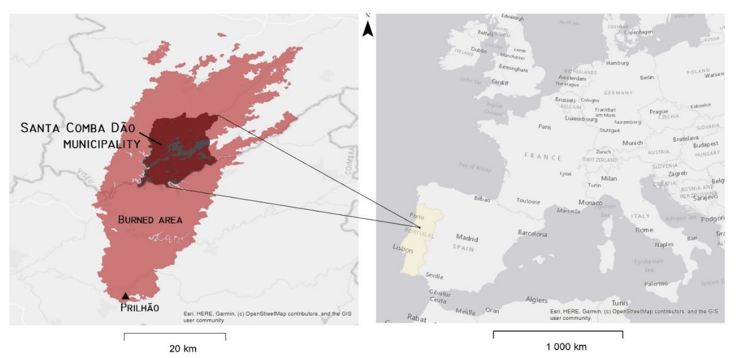
Fifteen people died and a total of 54,407 hectares (ha) were burned as a result of the Lousã extreme wildfire in the Central Region of Portugal [
27] that started at 08:41 (a.m.) on 15 October 2017 in the village of Prilhão, before quickly spreading to Santa Comba Dão municipality (
Figure 1).
This municipality was chosen as a case study because of its variety of land uses, its large burned area, and the high number of buildings impacted by the 2017 wildfire. Santa Comba Dão is an 11,195 ha town and municipality partially bordered by the Mondego River in the Viseu District, Central Region. It had a population of 11,597 inhabitants in 2011 [
28] and 10,641 inhabitants in 2021 [
29], corresponding to a population decrease of 8.4% in ten years.
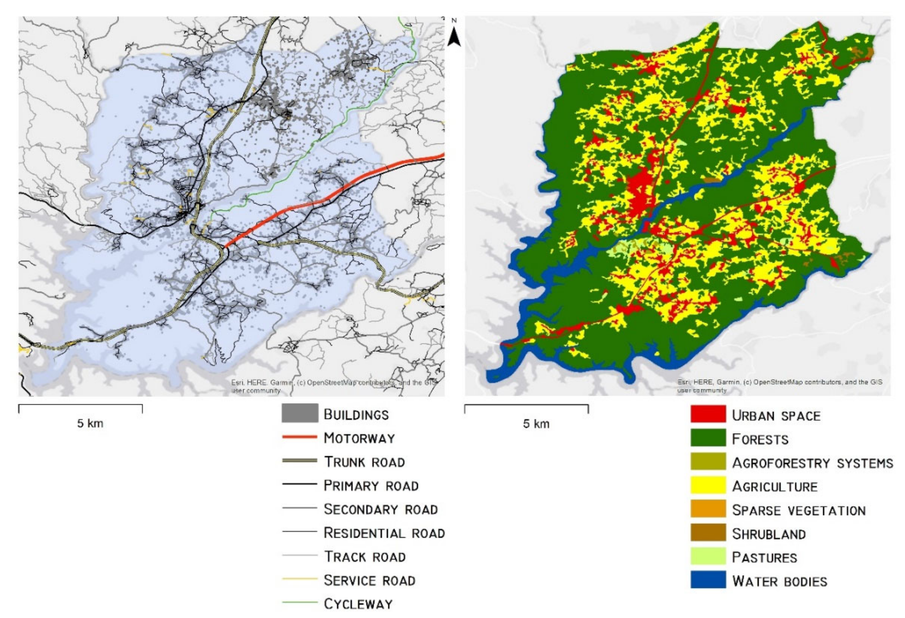
The municipality is divided into six civil parishes (Ovoa and Vimieiro; Pinheiro de Ázere; Santa Comba Dão and Couto do Mosteiro; São Joaninho; São João de Areias;and Treixedo and Nagozela). The main settlements are interconnected by a web of roads of different importance (
Figure 2).
Forests represent 60.03% of the municipal territory, with about 43% % of the forest area occupied by
Eucalyptus globulus [
30]. According to the Land Use/Cover Map (COS 2015), the remaining landscape structure is constituted by agriculture (23.03%), urban space (8.08%), water bodies (7.37%), pastures (0.41%), agroforestry systems (0.18%), and sparse vegetation (0.02%) [
31] (
Figure 2).
Eucalyptus globulus is present in recent plantations for pulp and paper; frequently on terraces in fragmented areas of poor management and land abandonment. In such forests, Eucalyptus is mixed with other tree species; mostly pines (Pinus pinaster), oaks (Quercus spp.), and the exotic Acacia dealbata.
The proliferation of eucalyptus in Portugal is in part explained by the occurrence of wildfires, which encourages forest owners to replace pine with species with shorter life cycles which are therefore compatible with recurrent fires [
32].
The areas burned on 15 October 2017 now exhibit massive
Eucalyptus wildlings, reaching hundreds of plants per square meter in some areas with limited presence of native shrubs (
Cistus psilosepalus,
Rubus sp.,
Ulex sp.) and herbaceous species (mostly
Pteridium aquilinum and
Rubia peregrina) [
30]. The presence of wildlings adds to the current dangerous naturalization of
Eucalyptus that is gradually increasing the likelihood of fire in many areas of Portugal [
30].
2.2. Data Assembly and Analysis
To study which factors determined building resistance in Santa Comba Dão, we ran exploratory regression models in which various data were assembled to assign a numerical value to each variable influencing structure survival.
Firstly, the building damage and loss during the 2017 wildfire was assessed using digital image interpretation in Google Earth [
33]. Vectorial data on primary housing reconstructed by the Portuguese Centre’s Coordination and Development Commission (CCDR-Centro) was given by the Santa Comba Dão City Council [
34]. To finalize the burned buildings database, some field visits were made to clarify doubtful identifications made during digital image interpretation.
Afterward, we defined three categories of house damage and loss from the resulting building damage and loss vectorial database: 0—Unaffected buildings; 1—Buildings little affected; 2—Buildings partially destroyed; and 3—Buildings completely destroyed) using a Geographic Information System (GIS).
Secondly, data referring to the definition of explanatory variables were assembled, before being extracted as multi-values to building damage and loss shapefile polygons in GIS. The variables were organized according to the following themes:
The variable regarding defensible space was:
Presence of trees and shrubs in a 30 m radius around the buildings affected: using digital image interpretation, we identified the affected buildings that had surrounding trees and shrubs before the 2017 wildfire. This variable was measured using digital image interpretation with the aim of studying the importance of non-compliance with the 30-meter defensible space in explaining the destruction of buildings in the municipality studied.
The landscape-scale variables were:
Distance to the forest: We used the Portuguese Land Use/Cover Map for 2015 (before the 2017 wildfire: COS 2015), provided by the Portuguese General Directory of Territory (DGT), to identify forested areas. The distance to forest areas was calculated in GIS, being the distance values integrated into each vectorial building polygon. This variable was chosen since it was assumed that buildings farther from forest areas would be more resilient to a rural fire.
Distance to major roads: the distance to major roads was calculated in GIS using a road shapefile, and values were extracted to each polygon of the building shapefile. The source of the road shapefile was Open Street Map [
35]. This variable was chosen because a greater distance of buildings from roads can result in less accessibility for firefighters, leading to more destruction of buildings.
Distance to minor roads: calculated in GIS as with major roads.
Building density: I was possible to calculate building density using the GIS Kernel density module and the building damage and loss shapefile. This variable was chosen because the scientific literature indicated that denser urban areas are more resistant to fires.
Euclidean nearest neighbor building: this landscape metric of building isolation was calculated from the housing database using the
Fragstats 4.2. software [
36], with results automatically aggregated to building polygons. This is an indicator of dispersion of buildings in the territory. As such, this variable was chosen in order to study whether more dispersed buildings were more damaged by the fire.
Slope: the slope map was determined in GIS from a digital elevation model (DEM) derived from satellite data (STRM) with a spatial resolution of 25 m [
37]. The slope values were then extracted through GIS for each building polygon. This variable was chosen in order to reveal its influence on the destruction of buildings by fire.
The type of construction materials used and the presence of concrete slabs can determine the destruction of a building. As such, related independent variables were included in the multiple linear regression. The variables related to building construction materials were:
Concrete structure: the number of buildings with reinforced a concrete structure was obtained from the shapefile of the Geographical Base for Referencing Information (BGRI) subsections of the 2011 Portuguese Census [
28]. The values were integrated into the study area building database using GIS.
Structures with slabs: the number of buildings constructed from masonry walls with slabs was calculated as with concrete structure.
Adobe structure: the number of buildings with constructed from adobe walls or loose stone masonry was calculated as above.
Other structure: the number of buildings with other types of structure was calculated as above;
Structures without slabs: the number of buildings with masonry walls without slabs was calculated as above.
The implantation area and the number of rooms in a building can affect the likelihood of destruction of the building. To test this influence in a multiple linear regression, we included the following variables based on building area:
Up to 50 m2: the number of buildings with an area up to 50 m2 within each BGRI subsection shapefile was calculated using the previous method.
50–100 m2: the number of buildings with an area between 50 and100 m2 within each BGRI subsection shapefile was calculated using the previous method.
100–200 m2: the number of buildings with an area between 100 and200 m2 within each BGRI subsection shapefile was calculated using the previous method.
More than 200 m2: the number of buildings with an area above 200 m2 within each BGRI subsection shapefile was calculated using the previous method.
1–2 rooms: the number of buildings with 1 or 2 rooms within each BGRI subsection shapefile was calculated using the previous method.
3–4 rooms: the number of buildings with 3 or 4 rooms within each BGRI subsection shapefile was calculated using the previous method.
In order to test the influence of the predominant land-use type in the place where each building is located on its destruction by fire, the following variables were selected for inclusion in the multiple linear regression:
Urban space: we distinguished between spaces listed as urban areas in COS 2015 and those that were not using binary differentiation in GIS (0–No urban space; 1–Urban space). These binary attribute values were then indexed to each building polygon in the study area.
Agriculture: the previous method was repeated for buildings located in areas described by COS 2015 as agriculture areas.
Forests: the previous method was repeated about the buildings located in areas described by COS 2015 as forest areas.
Agroforestry systems: the previous method was repeated for the buildings located in areas described by COS 2015 as agroforestry systems.
Pastures: the previous method was repeated for the buildings located in areas described by COS 2015 as pasture areas.
Shrubland: the previous method was repeated for the buildings located in areas described by COS 2015 as shrubland areas.
Sparse vegetation: the previous method was repeated about the buildings located in areas described by COS 2015 as containing sparse vegetation.
2.3. Multiple Regression Analysis
The entire previous data assembly was intended to identify the influence of each factor on the destruction of buildings by wildfire. In this context, the most robust and adequate method for studying this is multiple linear regression [
38]. For that reason, it was chosen as a main method.
The previous definition of three categories of house damage and loss expresses the degree of building damage. This served as the dependent variable in the multiple regression.
Five thematic multiple linear regression models were conducted using GIS and Statistical Package for the Social Sciences (SPSS) for Windows (Version 26) [
39] to identify the explanatory factors of Santa Comba Dão’s structural resistance to wildfire, based on explanatory variables on the following themes:
The multiple regression results for the five theme factors are presented and discussed in the next sections.
3. Results
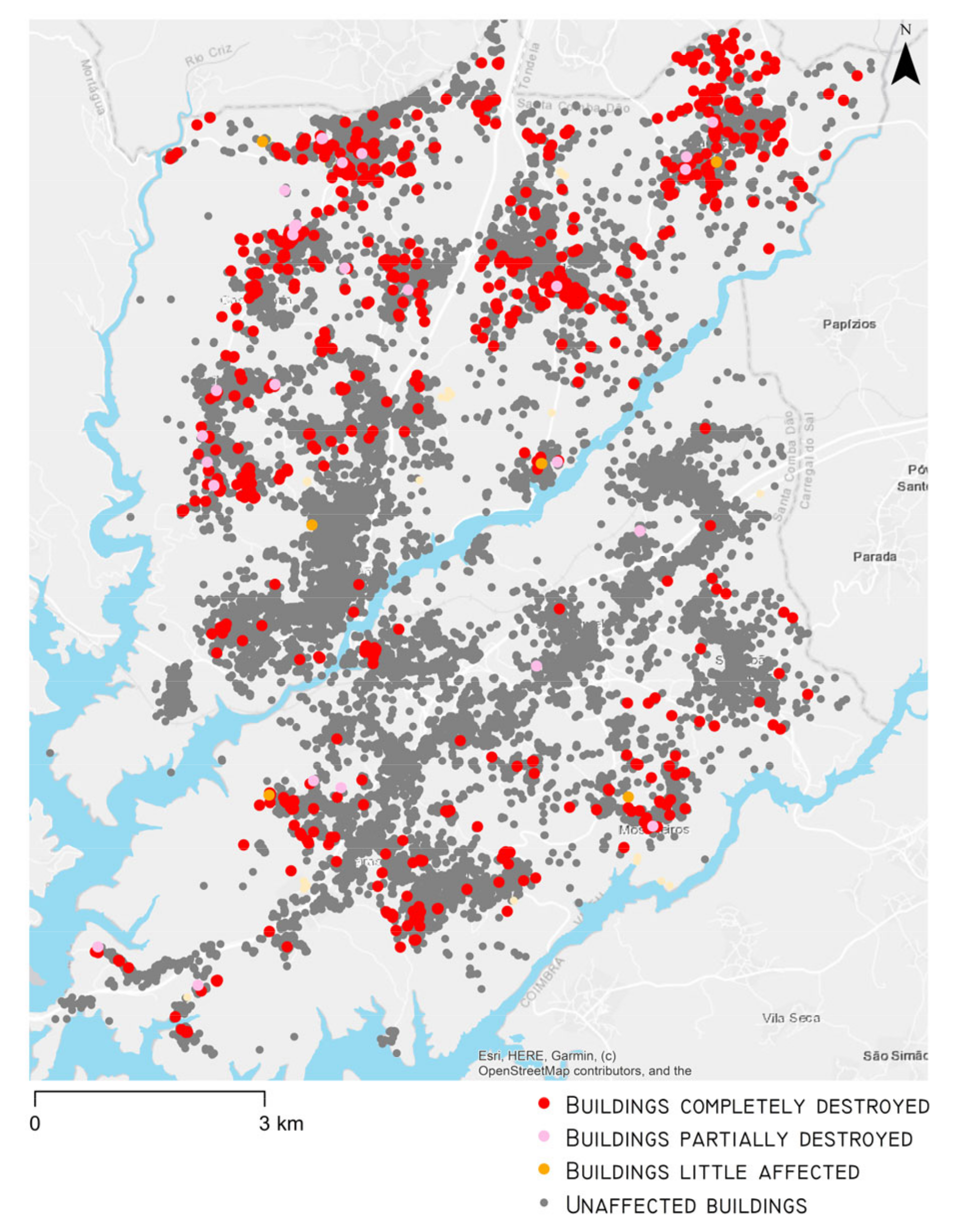
3.1. Number of Destroyed and Affected Buildings
From a total of 26854 buildings in Santa Comba Dão municipality, 2.9% (782) were completely destroyed, 0.12% (32) were partially destroyed (up to 50% of the implantation area affected), 0.03% (8) were slightly affected, and 96.90% (25,762) were not affected (
Figure 3).
3.2. Multiple Regression Regarding the Defensible Space
The presence of trees and bushes within a radius of 30 m from the buildings was the most important determining factor in the degree of damage/destruction of the buildings (β = 0.881;
p-value = 0). This variable accounted for 77.60% of the damage/destruction-degree variance (
Table 1).
3.3. Multiple Regression Regarding Landscape-Scale Factors
The influence of distance to forest areas (variable: distance to forest) had a negative influence (β = −0.042; p-value = 0). Therefore, it is possible to infer that the further away the buildings are from the forest areas, the less serious their destruction and thus the greater their resistance. The increasing distance to major (variable: distance to major roads) (β = 0.122; p-value = 0) and minor (variable: distance to minor roads) (β = 0.045; p-value = 0) roads had a statistically significant positive influence on damage and destruction. The greater the density of buildings in Santa Comba Dão (variable: building density), the less serious their destruction; the variable of building density displayed a negative influence (β = −0.023; p-value = 0.003). Neither the Euclidean nearest neighbor building, as a measure of isolation/proximity between buildings (variable: ENN building) nor the slope (variable: slope) presented any statistical significance for analysis purposes.
These independent variables only represented 2.4% (Adjusted R
2 = 0.024) of the variance of the dependent variable (degree of damage/destruction of buildings) (
Table 2).
3.4. Multiple Regression Regarding Building Construction Materials
A regression model was carried out to research the relationship between the degree of damage and the type of construction material of the buildings in the municipality under study at the scale of the BGRI subsection. It can be seen that the number of buildings with a reinforced concrete structure (variable: concrete structure) (β = −0.041; p-value = 0), buildings with a structure of masonry walls with slabs (variable: structure with slab) (β = −0.064; p-value = 0), buildings with a structure of adobe walls or loose stone masonry (variable: adobe structure) (β = −0.016; p-value = 0.011), and buildings with other types of structure (variable: other structure) (β = −0.020; p-value = 0.001), all have a clearly significant inverse relationship with the degree of damage. On the other hand, the number of buildings with masonry walls without slabs (variable: structure without slab) varied positively with the degree of damage to buildings affected by the 2017 wildfire (β = 0.020; p-value = 0.003).
These independent variables only represented 0.5% (Adjusted R
2 = 0.005) of the variance of the dependent variable (degree of damage/destruction of buildings) (
Table 3).
3.5. Multiple Regression Regarding Building Area
The BGRI number of houses with an area of 50 to 100 m
2 (variable: 50–100 m
2) (β = −0.080;
p-value = 0), with an area of 100 to 200 m
2 (variable: 100–200 m
2) (β = −0.036;
p-value = 0), with an area greater than 200 m
2 (variable: more than 200 m
2) (β = −0.024;
p-value = 0.001), and those that were a primary residence with one or two rooms (variable: 1–2 rooms) (β = −0.016;
p-value = 0.012), had an inverse influence concerning the degree of damage to the building (
Table 4). Smaller dwellings (with an area up to 50 m
2; variable: up to 50 m
2) (β = 0.019;
p-value = 0.026) and those with more rooms (variable: 3–4 rooms) (β = 0.051;
p-value = 0) seem to have less resistance due to their positive impact on the degree of damage.
These independent variables only represented 0.6% (Adjusted R
2 = 0.006) of the variance of the dependent variable (degree of damage/destruction of buildings) (
Table 4).
3.6. Multiple Regression Regarding Land Use Type at Building Location
According to the results of the multiple regression, the buildings located in impervious areas of urban space as defined in the COS 2015 map, show resistance in the event of a wildfire due to the negative influence of this variable on the degree of damage (variable: urban space) (β = −0.050;
p-value = 0) (
Table 5). Dispersed buildings, located in patches of forest (variable: forests) are more susceptible to damage; this is confirmed by the positive variation between this variable and the degree of damage/destruction (β = 0.079;
p-value = 0).
The other variables did not present statistical significance in this regression.
These independent variables only represented 1.2% (Adjusted R
2 = 0.012) of the variance of the dependent variable (degree of damage/destruction of buildings) (
Table 5).
4. Discussion
From the results of the Santa Comba Dão case study, it is possible to state that various factors present a predominant influence in building destruction, with some corroborating the influence of factors identified in the scientific literature.
Compared with the Australian and Californian studies [
5,
7,
8,
9,
10,
24,
25], it appears that non-compliance with a defensible space of 30 m is the most important factor determining building destruction. This factor was responsible for 77.60% of the variance in the degree of damage/destruction of buildings due to the 2017 wildfire. As such, the defensible space of 50 m regulated for Portuguese territory is excessive, leading to a herculean effort in human and financial resources that often do not exist.
An increasing distance to major and minor roads is also an influential variable for the degree of damage/destruction, reducing building resistance. It is noted that buildings located further away from main and secondary roads are less resistant due to the clear isolation from access to rescue means during the wildfire, as stated in other case studies [
7,
9,
15,
16,
17,
18,
19].
The distance from forest areas variable was elucidative, allowing us to say that the further away buildings are from forests, the more protected they will be.
An increase in building density was related to a decrease in the degree of building damage/destruction, reiterating the observation made in other case studies that high density of buildings is a factor in building resistance to wildfires [
1,
6,
14].
However, the distance to the forest, distance to major and minor roads, and building density only represented 2.4% of the factors responsible for the destruction of the buildings.
Innovative in this study is the proof that building dispersion is not a factor in resistance to wildfires; this was proven by the fact that the Euclidean nearest neighbor building explanatory variable did not show statistical significance. As such, this study does not corroborate the building’s vulnerability due to its isolation, as was observed in other case studies [
7,
16,
17,
18,
19].
Similarly, the slope was not a variable that showed statistical significance in explaining the buildings’ destruction, contrary to what has been verified in other empirical studies [
7,
9].
Regarding the building materials and building area variables, it appears that their contribution is not relevant to determine the destruction of the building.
Nonetheless, despite the independent variables relating to building materials only representing 0.5% of building-destruction variance, it should be noted that buildings with a concrete structure, with slabs, adobe structures, and other structures, all have more resistance; this conforms with the influence of some of these factors calculated by Syphard, Brennan and Keeley [
8]. On the other hand, buildings without slabs, which commonly have wood in their structure, have less resistance.
The building area variables also represented a tiny part (0.6%) of the variance of the building damage/destruction variable. In this context, buildings with a footprint of up to 50 m2 (sheds and garages) were less resilient to fire when compared to buildings with a larger footprint.
In turn, the land-use type where each building is located explained 1.2% of the variance of the degree of building damage/destruction. Thus, buildings located in consolidated urban spaces seem to be more protected from a wildfire impact. Considering that the minimum mappable unit of the COS is 1 hectare (ha), it is also possible to affirm that the buildings that form clusters of urban space with an area greater than 1 ha are characterized by greater resistance to damage or destruction to rural wildfire. In contrast, the existing buildings in forest areas reveal themselves to be deeply vulnerable.
Given what has been exposed so far, it appears that the explanatory variables together are responsible for 82.30% of the variance of the building damage/destruction degree by wildfires.
The non-compliance with the defensible space of a dimension of 30 m was responsible in this case study for 77.60% of the building destruction. From the point of view of public policies, these results show that the defensible space for existing buildings in Portuguese territory could perhaps be rethought to 30 m following a pilot project in the municipality studied or in other municipalities exposed to wildfires.
Given the results, spatial planning policies and integrated management of rural fires are correct to restrict new building permits in forest areas, but the building dispersion and the slope were not verified as factors involved in increasing the vulnerability of buildings to wildfires. Despite this, buildings located in consolidated urban areas are more resistant to wildfires. That said, the criterion to be taken into account for the granting of new building permits should be that they are not located in a forest area or near to a forest edge, regardless of whether it is in a consolidated or dispersed urban area.
Finally, although its results were not very significant, it appears that the Portuguese building codes regarding construction materials are supporting factors in building resistance.
5. Limitations
Since the multiple linear regressions only explained 82.30% of building destruction, it still remains to find the factors responsible for the other 17.70%.
Regarding construction materials and building area, there are no differences regarding the strength of the buildings. The same was found with the construction ages of the buildings, regression data relating to which are not presented since they did not show statistical significance. This may derive from the fact that the analysis of these variables was carried out at the scale of the statistical BGRI subsection and not at the building scale.
Over the years, masonry and tile roofs have been the main construction materials in Portuguese housing, including in Santa Comba Dão. These materials have a medium to high resistance to wildfires [
6], which was not studied in this case study. It was also not possible to confirm the influence of single- and multi-pane windows on Santa Comba Dão’s housing resistance to the 2017 wildfire.
Likewise, it was not possible to assess which buildings were occupied in order to define variables related to building use that could contribute to explaining the remaining variance in the degree of building damage/destruction.
Therefore, a research opportunity for the future will be to collect more detailed data about the construction materials, age, state of conservation, and use of each building before the wildfire, which will perhaps explain the missing factors that represent 17.70% of the variance of the building damage/destruction variable.
6. Conclusions
This research identified the main factors that should be taken into account in the definition of a municipal mitigation strategy to defend buildings against wildfires that can be extrapolated to municipalities with similar susceptibility and vulnerability to wildfires.
The main factors involved in the destruction of buildings by fire were identified, emphasizing that the non-compliance with a defensible space of 30 m around buildings is the factor that most determines the destruction of buildings. This finding corroborates what has been proven by the scientific literature regarding this subject, and such knowledge should have implications for public policies on fuel management around buildings.
Given that the human and financial resources of communities and institutions to comply with all fuel management strips are scarce and their use must therefore be well allocated, the Portuguese legal requirement of complying with 50 m of defensible space around buildings should be reduced to 30 m in favor of greater effectiveness and efficiency.
Therefore, the strategy should also include the prohibition of roof overhanging vegetation and the restriction of building permits in forest areas, and/or areas very far from major roads. Although there is no data regarding the differentiated presence of single- or multi-pane windows (with or without vinyl framing) on the study area buildings, it will always be recommendable, given the literature, to create incentives for their introduction into structures. All this should be combined with an efficient program to oversee and monitor its implementation.
Author Contributions
Conceptualization, A.S.-A. and F.T.; methodology, A.S.-A. and F.T.; formal analysis, A.S.-A. and F.T.; investigation, A.S.-A., J.A. and F.T.; resources, A.S.-A. and F.T.; data curation, A.S.-A. and F.T., writing—original draft preparation, A.S.-A. and F.T.; writing—review and editing, A.S.-A., F.T., J.A., F.C., D.M.P. and C.M.; supervision, F.T.; project coordination, F.T. All authors have read and agreed to the published version of the manuscript.
Funding
This research was supported by the project ‘AVODIS—Understanding and building on the social context of rural Portugal to prevent wildfire disasters’ (FCT Ref: PCIF/AGT/0054/2017), financed by national funds through Foundation for Science and Technology (FCT), Portugal. This research received dissemination support from the Centre of Studies in Geography and Spatial Planning (CEGOT), funded by national funds through the Foundation for Science and Technology (FCT) under the reference UIDB/04084/2020.
Data Availability Statement
Data sharing is not applicable to this article. The data are not publicly available due to the privacy of affected people and respective houses.
Conflicts of Interest
The authors declare no conflict of interest.
References
- Alexandre, P.M.; Stewart, S.I.; Mockrin, M.H.; Keuler, N.S.; Syphard, A.D.; Bar-Massada, A.; Clayton, M.K.; Radeloff, V.C. The relative impacts of vegetation, topography and spatial arrangement on building loss to wildfires in case studies of California and Colorado. Landsc. Ecol. 2016, 31, 415–430. [Google Scholar] [CrossRef]
- Ganteaume, A.; Barbero, R.; Jappiot, M.; Maillé, E. Understanding future changes to fires in southern Europe and their impacts on the wildland-urban interface. J. Saf. Sci. Resil. 2021, 2, 20–29. [Google Scholar] [CrossRef]
- Mockrin, M.H.; Stewart, S.I.; Radeloff, V.C.; Hammer, R.B.; Alexandre, P.M. Adapting to Wildfire: Rebuilding After Home Loss. Soc. Nat. Resour. 2015, 28, 839–856. [Google Scholar] [CrossRef]
- Penman, T.D.; Collins, L.; Syphard, A.D.; Keeley, J.E.; Bradstock, R.A. Influence of fuels, weather and the built environment on the exposure of property to wildfire. PLoS ONE 2014, 9, e111414. [Google Scholar] [CrossRef]
- Price, O.F.; Whittaker, J.; Gibbons, P.; Bradstock, R. Comprehensive examination of the determinants of damage to houses in two wildfires in eastern australia in 2013. Fire 2021, 4, 44. [Google Scholar] [CrossRef]
- Ribeiro, L.M.; Rodrigues, A.; Lucas, D.; Viegas, D.X. The impact on structures of the Pedrógão Grande fire complex in June 2017 (Portugal). Fire 2020, 3, 57. [Google Scholar] [CrossRef]
- Syphard, A.D.; Keeley, J.E.; Massada, A.B.; Brennan, T.J.; Radeloff, V.C. Housing arrangement and location determine the likelihood of housing loss due to wildfire. PLoS ONE 2012, 7, e33954. [Google Scholar] [CrossRef] [PubMed] [Green Version]
- Syphard, A.D.; Brennan, T.J.; Keeley, J.E. The role of defensible space for residential structure protection during wildfires. Int. J. Wildland Fire 2014, 23, 1165. [Google Scholar] [CrossRef]
- Syphard, A.D.; Brennan, T.J.; Keeley, J.E. The importance of building construction materials relative to other factors affecting structure survival during wildfire. Int. J. Disaster Risk Reduct. 2017, 21, 140–147. [Google Scholar] [CrossRef]
- Syphard, A.D.; Keeley, J.E. Factors associated with structure loss in the 2013–2018 California wildfires. Fire 2019, 2, 49. [Google Scholar] [CrossRef]
- Cohen, J.D. Preventing Disaster: Home Ignitability in the Wildland-Urban Interface. J. For. 2000, 98, 3–15. [Google Scholar]
- Cohen, J.D. Relating flame radiation to home ignition using modeling and experimental crown fires. Can. J. For. Res. 2004, 34, 1616–1626. [Google Scholar] [CrossRef]
- Penman, S.H.; Price, O.F.; Penman, T.D.; Bradstock, R.A. The role of defensible space on the likelihood of house impact from wildfires in forested landscapes of southeastern Australia. Int. J. Wildland Fire 2019, 28, 4. [Google Scholar] [CrossRef]
- Miner, A. Defensible Space Optimization for Preventing Wildfire Structure Loss in the Santa Monica Mountains; Johns Hopkins University: Baltimore, MD, USA, 2014. [Google Scholar]
- Keeley, J.E.; Safford, H.; Fotheringham, C.J.; Franklin, J.; Moritz, M. The 2007 Southern California Wildfires: Lessons in Complexity. J. For. 2009, 107, 287–296. [Google Scholar]
- Keeley, J.E.; Fotheringham, C.J.; Morais, M. Reexamining Fire Suppression Impacts on Brushland Fire Regimes. Science 1999, 284, 1829–1832. [Google Scholar] [CrossRef] [Green Version]
- Lampin-Maillet, C.; Jappiot, M.; Long, M.; Bouillon, C.; Morge, D.; Ferrier, J.P. Mapping wildland-urban interfaces at large scales integrating housing density and vegetation aggregation for fire prevention in the South of France. J. Environ. Manag. 2010, 91, 732–741. [Google Scholar] [CrossRef] [Green Version]
- Syphard, A.D.; Radeloff, V.C.; Hawbaker, T.J.; Stewart, S.I. Conservation Threats Due to Human-Caused Increases in Fire Frequency in Mediterranean-Climate Ecosystems. Conserv. Biol. 2009, 23, 758–769. [Google Scholar] [CrossRef]
- Syphard, A.D.; Radeloff, V.C.; Keeley, J.E.; Hawbaker, T.J.; Clayton, M.K.; Stewart, S.I.; Hammer, R.B. Human influence on california fire regimes. Ecol. Appl. 2007, 17, 1388–1402. [Google Scholar] [CrossRef] [PubMed]
- Quarles, S.L.; Valachovic, Y.; Nakamura, G.M.; Nader, G.A.; de Lasaux, M.J. Home Survival in Wildfire-Prone Areas: Building Materials and Design Considerations; University of California, Agriculture and Natural Resources: Richmond, CA, USA, 2010. [Google Scholar] [CrossRef] [Green Version]
- Caton, S.E.; Hakes, R.S.P.; Gorham, D.J.; Zhou, A.; Gollner, M.J. Review of Pathways for Building Fire Spread in the Wildland Urban Interface Part I: Exposure Conditions. Fire Technol. 2017, 53, 429–473. [Google Scholar] [CrossRef]
- Bowditch, P.A.; Sargeant, A.J.; Leonard, J.E.; Macindoe, L. Window and Glazing Exposure to Laboratory-Simulated Bushfires; Report to the Bushfire CRC, A Bushfire CRC initiative; Bushfire CRC: Melbourne, Victoria, Australia, 2006. [Google Scholar]
- Cuzzillo, B.R.; Pagni, P.J. Thermal Breakage of Double-Pane Glazing By Fire. J. Fire Prot. Eng. 1998, 9, 1–11. [Google Scholar] [CrossRef]
- Whittaker, J.; Haynes, K.; Handmer, J.; McLennan, J. Community safety during the 2009 Australian “Black Saturday” bushfires: An analysis of household preparedness and response. Int. J. Wildland Fire 2013, 22, 841. [Google Scholar] [CrossRef]
- McLennan, J.; Ryan, B.; Bearman, C.; Toh, K. “Should we leave now? ”: Behavioral factors in wildfire evacuation. Fire Technology 2018, 55, 487–516. [Google Scholar] [CrossRef]
- Mccaffrey, S.M.; Rhodes, A. Public Response to Wildfire: Is the Australian “Stay and Defend or Leave Early” Approach an Option for Wildfire Management in the United States? J. For. 2009, 107, 9–15. [Google Scholar]
- Viegas, D.X. Análise dos Incêndios Florestais ocorridos a 15 de Outubro de 2017; Centro de Estudos sobre Incêndios Florestais, Departamento de Engenharia Mecânica, Faculdade de Ciências e Tecnologia, Universidade de Coimbra: Coimbra, Portugal, 2019. [Google Scholar]
- INE (2013). Population by Parish. Census 2011 (Definitive Results). Portuguese National Institute of Statistics (INE): Portugal, Lisbon. Available online: https://www.ine.pt/xportal/xmain?xpid=INE&xpgid=ine_publicacoes&PUBLICACOESpub_boui=122103956&PUBLICACOESmodo=2 (accessed on 7 November 2021).
- INE (2021). Population by Parish. Census 2021 (Preliminary Results). Portuguese National Institute of Statistics (INE): Portugal, Lisbon. Available online: https://www.ine.pt/scripts/db_censos_2021.html (accessed on 9 November 2021).
- Silva, J.S.; Nereu, M.; Pinho, S.; Queirós, L.; Jesús, C.; Deus, E. Post-Fire Demography, Growth, and Control of Eucalyptus globulus Wildlings. Forests 2021, 12, 156. [Google Scholar] [CrossRef]
- DGT. Direção Geral do Território. DGT: Portugal, Lisboa. Available online: https://www.dgterritorio.gov.pt/dados-abertos (accessed on 24 October 2021).
- Turco, M.; Jerez, S.; Augusto, S.; Tarín-Carrasco, P.; Ratola, N.; Jiménez-Guerrero, P.; Trigo, R.M. Climate drivers of the 2017 devastating fires in Portugal. Sci. Rep. 2019, 9, 13886. [Google Scholar] [CrossRef] [Green Version]
- Google Earth Pro. Available online: http://www.google.com/earth/ (accessed on 25 October 2021).
- CMSCD. Câmara Municipal de Santa Comba Dão. CMSCD: Santa Comba Dão, Portugal. Available online: https://cm-santacombadao.pt/ (accessed on 25 October 2021).
- OpenStreetMap. Available online: https://www.openstreetmap.org/#map=13/40.4581/-8.0662 (accessed on 25 October 2021).
- McGarigal, K.; Marks, B.J. FRAGSTATS: Spatial Pattern Analysis Program for Quantifying Landscape Structure; General Technical Report; Department of Agriculture, Forest Service, Pacific Northwest Research Station: Portland, OR, USA, 1995. [Google Scholar] [CrossRef]
- CIIMAR. STRM Digital Elevation Model with Spatial Resolution of 25 m. Coastal Monitoring and Management Group. Available online: https://www.fc.up.pt/pessoas/jagoncal/dems/ (accessed on 9 November 2021).
- Tabachnick, B.G.; Fidell, L.S.; Ullman, J.B. Using Multivariate Statistics; Pearson: Boston, MA, USA, 2007. [Google Scholar]
- Statistical Package for the Social Sciences (SPSS) for Windows, Version 26; IBM: Armonk, NY, USA, 2019.
| Disclaimer/Publisher’s Note: The statements, opinions and data contained in all publications are solely those of the individual author(s) and contributor(s) and not of MDPI and/or the editor(s). MDPI and/or the editor(s) disclaim responsibility for any injury to people or property resulting from any ideas, methods, instructions or products referred to in the content. |
© 2023 by the authors. Licensee MDPI, Basel, Switzerland. This article is an open access article distributed under the terms and conditions of the Creative Commons Attribution (CC BY) license (https://creativecommons.org/licenses/by/4.0/).


 ,
, 


