1. Introduction
The severity of forest fires in Portugal between 2017 and 2018 triggered the beginning of a transformative change in the public policy of forest fire management in the country. A transition from a reactive policy (focused on emergency response and firefighting) toward a more anticipatory approach that emphasizes risk reduction is now being followed [
1]. The Portuguese National Plan for Integrated Rural Fire Management—PNGIFR [
2] was supported by a critical assessment of systemic failures in forest fire reduction and highlighted the importance of integrating local communities (particularly land and forest owners) in the risk assessment process with an integrated management perspective. An Independent Technical Commission, responsible for evaluating the 2017 forest fires in Portugal, also stressed that local communities are an important source of accumulated knowledge about both the fragilities of the territory and the most suitable protective behaviors, being therefore imperative to mobilize them [
3]. Indeed, it appears that there is accumulated knowledge on the risk factors and local vulnerabilities of forest territories at the community level, as well as on intuitive ways of adapting to risks. This knowledge should be captured and used in forest fire risk reduction.
The literature is rich in arguments and examples concerning the importance of recognizing the diversity of actors, namely communities involved in forest fire risk management, highlighting their plurality of views, values, and perspectives, as well as different knowledge systems and practices [
4,
5]. The experiences and knowledge of communities living in disaster risk areas allow identifying the historical hazards events [
6], and the fire risk management measures adopted by communities [
7], providing a better understanding of local risks and vulnerabilities. It also reveals the importance of considering a more holistic view of the local context in the design of tailor-made strategies that combine different strategic pathways [
8]. Local experiences, knowledge, and practices are thus recognized in the field of fire science research literature as key in the promotion of forest fire risk reduction [
9,
10] and building fire-adapted communities (FACs) [
11,
12]. Varela et al. (2022) [
13] reinforce that the resilience of forest territories is more easily created and maintained by utilizing the knowledge, resources, and skills of communities in fuel treatment and adaptive management of disaster risks.
However, local communities’ perceptions and practices related to forest fire management are influenced by a complex set of factors linked to a specific local context [
8], as well as by communities’ structural conditions, such as development patterns, biophysical conditions, and demographic/socio-economic influence [
14]. Paveglio and Edgeley (2017) [
15] emphasize the need to consider the diversity of communities, their different social dynamics, history, and interactions, which are reflected in distinct forms of experience around a fire event [
16] and also in different forest fire management strategies [
17]. It is therefore important to consider the diversity of local knowledge associated with the characteristic patterns of the local social context and the varying structural conditions of communities to guide and combine different strategic pathways in adapting to forest fires [
8,
11,
17]. Thus, identifying and understanding social complexity in a fire-prone area is needed to target and recognize the diverse local knowledge and its specificities, to guide tailored programs, incentives, and policies likely to be better supported and/or developed by these communities in the long-term [
9,
18].
In addition to recognizing and valuing the diversity of local knowledge and experience related to specific contexts of communities living in risk areas, it is necessary to promote the active role of those local communities in disaster risk reduction (DRR). Integrating communities and encouraging their active role contributes to building policies and programs appropriate to the local context [
19]. Expected results include better-integrated forest fire planning and management [
20,
21], as well as promoting forest fire adaptation as part of the local culture [
22]. The Sendai Framework for Disaster Risk Reduction 2015–2030, adopted at the 3rd UN World Conference on DRR in Sendai, Japan (access
https://bit.ly/3Nn9ukz, accessed on 21 June 2022), presents targets and priorities for action to prevent and reduce disaster risks and has incorporated the community-based disaster risk reduction (CBDRR) approach [
23]. CBDRR is a participatory process-based approach that places communities at the center of a disaster risk investigation process, in order to address issues, challenges, and problems from the perspective of those who experience them every day [
24]. It, therefore, aims to foster the participation of threatened communities in both the assessment of risks (including hazards, vulnerability, and capacities) and ways to reduce them. Thus, the purpose of the CBDRR is to recognize and value local knowledge, by collectively engaging communities, including individuals, living in risk areas, encouraging them to take an active role in the identification, analysis, and management of disaster risks [
25].
The literature also suggests that in such community-based processes the adoption of participatory approaches is essential to engage communities living in risk areas, capture local knowledge and resources available in the territories and strengthen adaptive capacities [
26]. In particular, community participation through participatory mapping (PM), also known as volunteered geographic mapping [
27], is considered an interactive approach that uses visual methods to access individual and community knowledge, which enables blending mapping activities with other participatory approaches for reducing disaster risks (e.g., community risk assessment methods), and which has been widely adopted in CBDRR processes [
28].
As illustrated by some authors, for example, Cadag and Gaillard (2012) [
6], the PM method allows a visual expression of the realities perceived by communities (individual and collectively), building on key territorial characteristics that are inevitably “filtered” by people experiences and perceptions [
29]. This method seems therefore to contribute to the identification of critical issues as well as to the illustration and interpretation of risk areas and local vulnerabilities, allowing desired and useful community risk reduction measures to be addressed [
6]. Thus, it can be argued that PM represents an opportunity to (i) promote social learning, (ii) broaden the understanding and preparedness for forest fire risk, and (iii) strengthen the community’s connectedness and involvement in DRR, representing an important social practice to enhance adaptive capacities [
27]. Promoting social practices with communities living in at-risk areas helps to build personal and collective identities, and knowledge for fire risk management [
7], support social learning and new practices [
30], and enact ways of sharing tasks and responsibility to achieve local resilience [
31].
As to the potential contributions of the PM integrated into CBDRR processes, Gaillard and Mercer (2012) [
32] highlight: (i) the recognition of communities’ local knowledge and their active role in risk identification and assessment, (ii) guiding disaster risk reduction strategies while using participatory planning and decision-making processes logic as well as bottom-up perspectives and, (iii) contributing to the (re)orientation of territorial development models in plans, programs and policies that incorporate a disaster risk perspective. PM is also considered to give voice and power to communities, contributing to making local knowledge credible to scientists and local governments [
6] and facilitating a fair and balanced dialogue between local communities and government agencies, NGOs, and scientists [
33].
Haworth et al. (2018) [
34] highlights that volunteered geographic information (VGI) methods, including PM, facilitate the collection of local knowledge by providing contextual data at appropriate spatial-temporal scales of relevance to communities. However, the quality and reliability of the data collected, including elements such as positional accuracy and content inaccuracies, are among the limitations of using methods based on participatory cartography. This limitation is also associated with the issues of scale and georeferencing of the drawn maps, pointed out by Cadag and Gaillard (2012) [
6]. Another main issue is to make the local knowledge obtained in participatory mapping credible, both to the members of the local communities involved in the mapping and to local governments and the scientific community [
32]. These issues, therefore, are important to consider and address when planning and implementing VGI methods with communities living in disaster risk areas.
Currently, although the scientific literature recognizes the importance of incorporating local knowledge and the active role of local communities to enhance and strengthen adaptive capacities to fire risk, in fire risk research participatory action appears to still be neglected. We see this as a gap that needs to be addressed through actions that value the knowledge and voices of local communities [
13]. Vigna et al. (2021) [
10] point out that participatory approaches need to be further developed to make community involvement in fire risk areas a central (nonnegligible) aspect of the forest fire issue. Regarding the central approach of this research, the literature searched in official scientific databases (e.g., Scopus and Web of Science), showed a lack of studies focusing on the recognition of local knowledge and engagement in forest fire-prone areas through participatory approaches integrated into the CBDRR process, namely the participatory mapping method. Thus, this paper aims to contribute to this gap by sharing the process and results with the application of participatory mapping involving landowners, mostly forest owners, located in a forest fire risk area in Portugal, the municipality of Monchique. In addition to collecting information from the perspective of land and forest owners on current risks and vulnerabilities to forest fires, and proposing measures aligned with the expectations of these local actors, this analysis aims to highlight the contribution of participatory mapping in recognizing local knowledge and the active role of communities driving a CBDRR process.
BRIDGE Project
BRIDGE (bridging science and local communities for forest fire risk reduction) is a Portuguese participatory action research project designed to develop an approach to integrate different forms of knowledge and action with a focus on forest fire risk reduction (more information about the project at:
https://bridgecomunidade.pt/en/home-2/, accessed on 21 June 2022). The BRIDGE project is funded by the Portuguese Foundation for Science and Technology (PCIF/AGT/0072/2019) and is carried out by a consortium coordinated by the
Instituto Superior Técnico (IST), from the University of Lisbon, and includes as partners the
Laboratório Nacional de Engenharia Civil (LNEC) and the University of
Algarve (UALg). It aims to interconnect and integrate local and scientific knowledge, encourage local, collective, and preventive agencies, and strengthen adaptive capacity with a focus on forest fire risk reduction strategies using a CBDRR perspective. The BRIDGE project is being developed in the municipality of
Monchique, which acts as a pilot case for forest fire-prone areas located in the
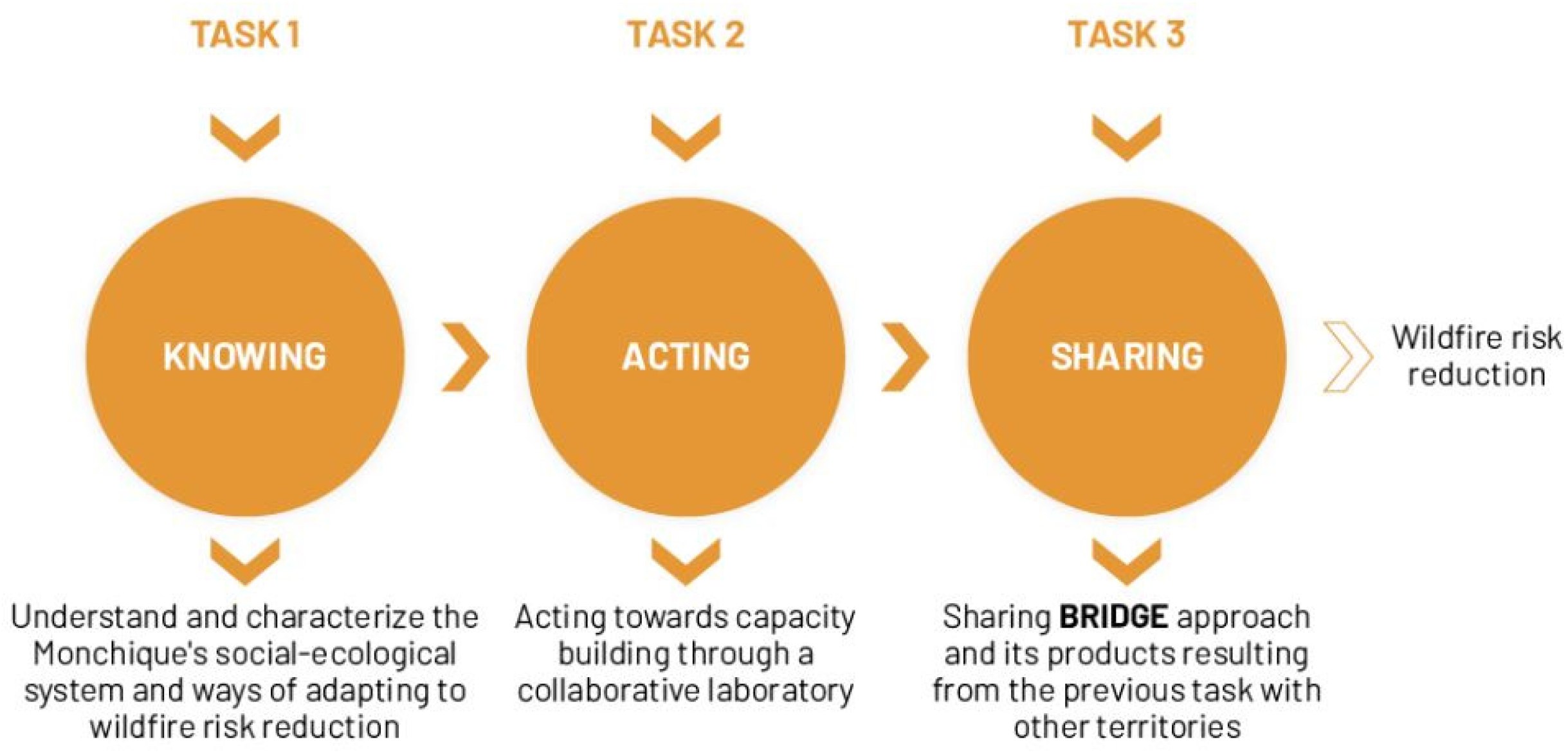
Algarve region, Southern Portugal. The project is structured into three main tasks (
Figure 1).
The BRIDGE project’s first task aimed to understand the territory of Monchique, identifying, and assessing the socio-ecological vulnerabilities and the local strategies of adaptation to forest fire risk. Task 2 is supported by the development of a collaborative innovation laboratory (InnoLab) that acts as the essence of participatory action research. It brings together relevant scientific, public, and private agents that act, directly or indirectly, in the management of the forest territory. The InnoLab aims to provide a collective space to promote dialogue, knowledge sharing and collective debate in the Monchique territory to (i) promote social learning on key aspects of local vulnerabilities and forest fire risks, (ii) strengthen collaborative networks, (iii) build and enhance both social and institutional adaptive capacities for forest fire risk reduction, and (iv) encourage a CBDRR participatory process approach in Monchique. Task 3 of the project aims at sharing the knowledge, tools, and experiences of social learning and local capacity for forest fire risk reduction developed within the BRIDGE project to encourage its replication in other territories vulnerable to forest fires, in Portugal and other countries.
The following sections will (i) address the methods used in the participatory mapping with the Monchique rural landowners in a CBDRR context, (ii) share the results obtained with such process, and (iii) discuss and present the key outcomes of this paper.
2. Methods
2.1. Literature Review
The literature review aimed to deepen the analysis and understanding of the core concepts of this research, using the following keywords: local knowledge, community-based disaster risk reduction (CBDRR), and participatory mapping. These concepts were investigated and analyzed within the context of disaster risk reduction (DRR) in general and forest fire in particular. A non-exhaustive search was conducted in scientific literature sources, namely Scopus and Web of Science, applying the filters “Cited by (highest)” and “Date (newest)”. The literature review included a broad search to identify publications in the field of the social sciences of fire, namely case studies, where participatory approaches were adopted to recognize local knowledge and promote the active role of communities in the reduction of forest fire risks. The results obtained are presented in
Table 1.
The search for “Community-based disaster risk reduction” (also searched as CBDRR), identified 5 publications that showed the adoption of CBDRR processes with the use of traditional methods of data collection and analysis, namely questionnaires, interviews, and focus group, with no participatory mapping techniques being integrated into the process. Under the keyword “Community approach” a single result was identified associated with the word wildfire; however, this research is based on a policy tool approach focused on capacity-building, and direct relation with the approach of this research cannot be verified.
The search for the keyword “Participatory method” (and “Participatory methodology”) associated with the words forest fire, wildfire, and/or bushfire resulted in a higher number of publications (07); however, such participatory approaches focus on the development of interviews and focus groups, as verified in the search for the word CBDRR. Finally, the search for the keyword “Participatory Mapping” resulted in a higher number of 10 publications; however, it was shown to represent an application of volunteered geographic information (VGI) techniques, i.e., the use of the participatory mapping method (or other participatory cartography techniques) was adopted without being embedded in a broader community process focused on the engagement and active role of communities in fire risk reduction, such as the Community Risk Assessment (CRA), the Participatory Rural Appraisal, or even the CBDRR.
2.2. Pilot Case
The municipality of Monchique is located in the southern region of Portugal, in the region of Algarve, and is divided into three parishes: Parish of Monchique (center), Parish of Marmelete (west), and Parish of Alferce (east). In this region, 711 forest fires were recorded in 2018 resulting in a burnt area of 271.54 km
2, most of it in Monchique municipality (representing 7.3% of the total number of events and 71% of the area burnt in the country in 2018). The severe forest fire that occurred in Monchique in 2018, although it did not report any fatalities, resulted in incalculable damage to environmental heritage, infrastructure, and personnel in the region, according to the Monchique Fire Assessment Report prepared by the Independent Technological Observatory [
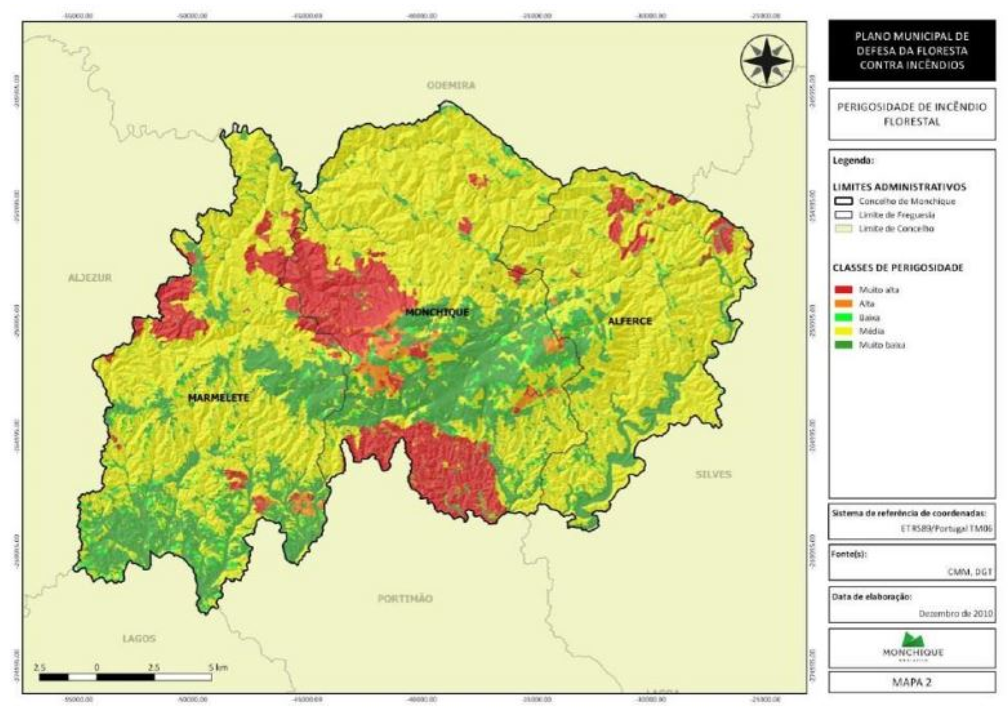
35]. Monchique has extensive areas of its territory classified as “high” and “very high” forest fire risk areas, as shown in
Figure 2 [
36], and was classified by the Institute for Nature Conservation and Forests (ICNF) as a priority intervention area for forest fire risk reduction in Portugal.
Monchique’s total area is 395.30 km2 with 65.7% of its territory (259.83 km2) occupied by forests. According to 2021 data from the National Statistics Institute (INE), 69.7% of the total forest area (181.08 km2) is eucalyptus plantations, which increases the risk of forest fires. The eucalyptus is a tree with inflammable oils and its bark bursts into flames at great distances, causing new outbreaks of fire. Despite this significant area with eucalyptus occupation, data reveals a considerable reduction in the number of profitability forestry production units (75%), with profitable units decreasing from 98 in 2009 to 56 in 2019. These data reveal a decline in profitability associated with the market and external economic drivers with effects on the production costs and reduction of local productive capacity, increasing abandonment of forested areas.
Similarly, the 2021 Census reveals a decrease of 9.6% of Monchique population in comparison with 2011, now accounting for 5462 inhabitants, with a gradual tendency towards an aging population and depopulation of rural areas. In addition, in relation to population data, the 2021 Census indicates that the foreign population, i.e., immigrants with permanent residence in Monchique, represented 13.0% of the total resident population (710 inhabitants), an increase when compared to 2011 when resident foreigners represented 8.6%.
This brief note on the Monchique municipality reinforces a problematic context, common to other territories of Portugal susceptible to forest fires, and which results in higher vulnerability and increased risks to forest fires, namely: the depopulation of rural areas, loss of local productive capacity, devaluation of rural land, abandonment or lack of management of forest areas with an accumulation of flammable materials, conflicts of visions and interests between actors among others [
37,
38]. In addition, and as mentioned, the ICNF classifies Monchique as a priority intervention area given its high vulnerability to forest fires in a socio-economic and socio-ecological context of fire risk.
Therefore, the BRIDGE project selected this municipality as a pilot case. While the InnoLab will run throughout the whole of Task 2, between March 2022 and February 2023, this paper is concerned with the experience so far developed with the participatory mapping engaging landowners in an early stage of the project Task 2.
2.3. Data Collection for Participatory Mapping
The data were collected through the development of three workshops between March and April of 2022. The workshops consisted of the participatory mapping of risk areas and vulnerabilities to forest fires in Monchique and involved local landowners, most of whom have forest fragments on their property. The selection of Monchique’s landowner community as the target group for these workshops was due to the fact that: (i) they represent most of the population directly affected by fires, (ii) they have valuable knowledge about that forest territory, and (iii) they are responsible for managing local private forest areas, which includes having the responsibility to adopt good practices to reduce forest fire risks and to implement self-protection measures.
Most of the landowners involved in the participatory mapping activity are members of one of the following local organizations: Barlavento Algarvio Forestry Producers Association (Aspaflobal) and/or Monchique Agricultural Cooperative (Coopachique), A Nossa Terra Environmental Association, and Monchique Alerta Association, formed by local landowners affected by the forest fire of 2018. The identification of these organizations was developed in the BRIDGE project diagnostic phase (Task 1).
The mobilization of the target public for the participatory mapping (i.e., the landowner community of Monchique) was made by the BRIDGE project team and the representatives of the identified local organizations. First, we jointly defined the agenda (day/time) and the most suitable sites for the workshops. Then, the announcement of the workshops was disseminated by phone and e-mail, inviting all landowners who are members of these local organizations. The information about the workshops was also sent to the Monchique Municipal Council (CMM) to call for the engagement of other local landowners.
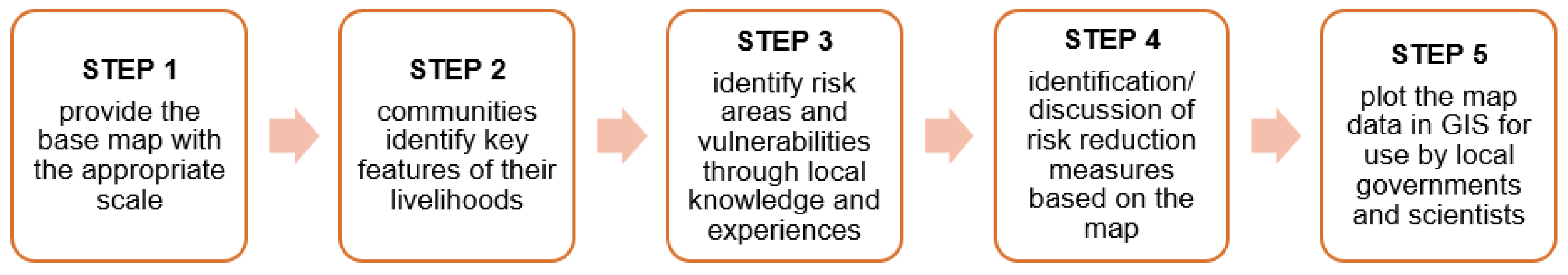
In this case, we adapted the procedure proposed by Gaillard and Maceda (2009) [
28], reproduced in
Figure 3. The procedure is structured in five steps and began with the preparation of the working base map containing only reference information (boundaries, roads, and main localities), using Google Earth digital terrain image of Monchique on a 1:25,000 scale.
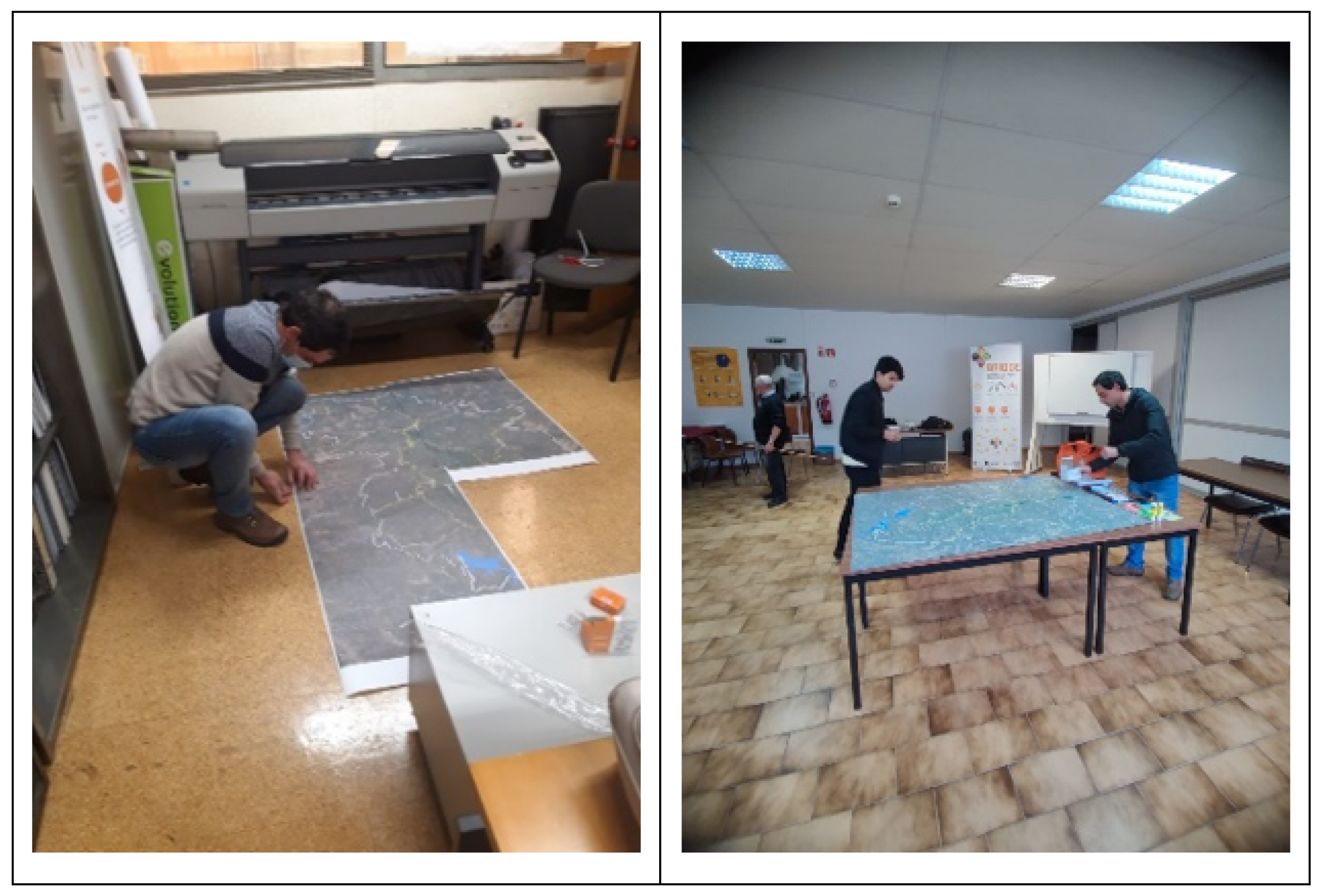
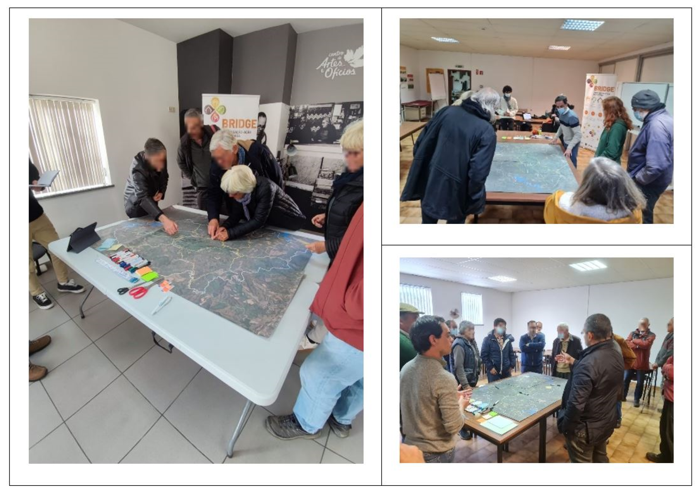
Figure 4 illustrates the preparation of the base map and of the support materials and spaces for the workshops.
The second step was simplified to focus on specific aspects of daily community life and to ensure more time was allocated to mapping key forest fire issues (following steps). It consisted in gathering the workshop participants around the map and asking them to identify on the map the location of their residence and/or property, local access roads mostly used for daily travel, and forest areas of interest and/or relevance.
Then, step three focused on local areas of risk and vulnerability to forest fires, and participants were asked to identify if there are residents who are more vulnerable to forest fires (children, the elderly, people with special needs, etc.), the current areas susceptible to forest fires, and the risk factors and vulnerabilities to forest fires in the territory.
The participants’ interaction with the map led to a collective reflection and debate on possible measures for forest fire risk reduction (Step 4), allowing also to pinpoint some information on strategies tailored to the local context and to the landowners’ expectations. Not being a rigid procedure, Steps 3 and 4 were developed interconnectedly, with some back and forward between the identification of risks and vulnerabilities and the respective possible measures.
After the workshops, the collected information was organized, analyzed, and integrated into the Project Technical Report and the Georeferenced Database (GIS), containing information on the location of residences and/or properties of the participants, identification of the most vulnerable residents in a forest fire context, identification of the most used local access routes, localization of forest fragments of interest or relevance, location of forest fire-prone areas, the main risk factors and local vulnerabilities, and possible measures for reducing forest fire risks from a bottom-up perspective and aligned with the expectations of the local community (step 5).
Noteworthy that the participatory mapping with rural landowners aimed to collect knowledge and perceptions of these actors and build a local database to be used as a source of information by local governments and scientists in an integrated manner with other “official” databases (technical and scientific). Thus, the information presented below has been reproduced as manifested by the participants (and recorded in the workshops) without any “filter” through the scientific lens, such as validating the veracity of the risk factors indicated by the landowners or if the measures for risk reduction proposed by them are feasible. This approach aimed to guarantee that this local database obtained from participatory mapping represents, as faithfully as possible, the participants’ vision and that it is recognized and validated by the rural landowners of Monchique themselves.
3. Results
In total, 30 local landowners were involved in the participatory mapping of local risk areas and vulnerabilities to forest fires in Monchique through three workshops, one for each local organization (
Figure 5). The landowners were, in general, members of the local organizations identified in the previous section, and represent different points of view, experiences, and interests about the forest territory in Monchique. Only five landowners, who participated in the workshop with members of Aspaflobal and/or Coopachique as forest producers, mentioned not belonging to any of the organizations (
Table 2).
It is possible to distinguish the participants in two groups in relation to their different interactions with forest territories in Monchique: (i) a first group that views the forest and its resources as a source of family income based on forest production and, (ii) a second one that views the forest territories as a landscape and local biodiversity valorization. The first group is mostly represented by individual national landowners who explore forest resources as their basic livelihood and by corporate producers who explore the eucalyptus forest for pulp and paper production. The second group includes mainly foreign local landowners living in Monchique who use their property for farming for self-consumption and/or leisure and recreational practices. With different perspectives about the forest, the second group verbalizes their concerns around the eucalyptus monoculture in Monchique, emphasizing the importance of promoting native vegetation and preserving the local forest resources.
Despite the different backgrounds, visions, and interests between the two groups, an interesting result that emerged from the workshops was the identification of common perceptions and of convergent local knowledge among the landowners about the current fire-prone areas, the main forest fire risk factors, and the vulnerabilities of Monchique’s forest territory. This finding contributes to reinforcing the notion that the data and information obtained with participatory mapping can be useful to reflect the context of forest fires in Monchique (in this case based on the landowners’ community perspective who participated in the workshops).
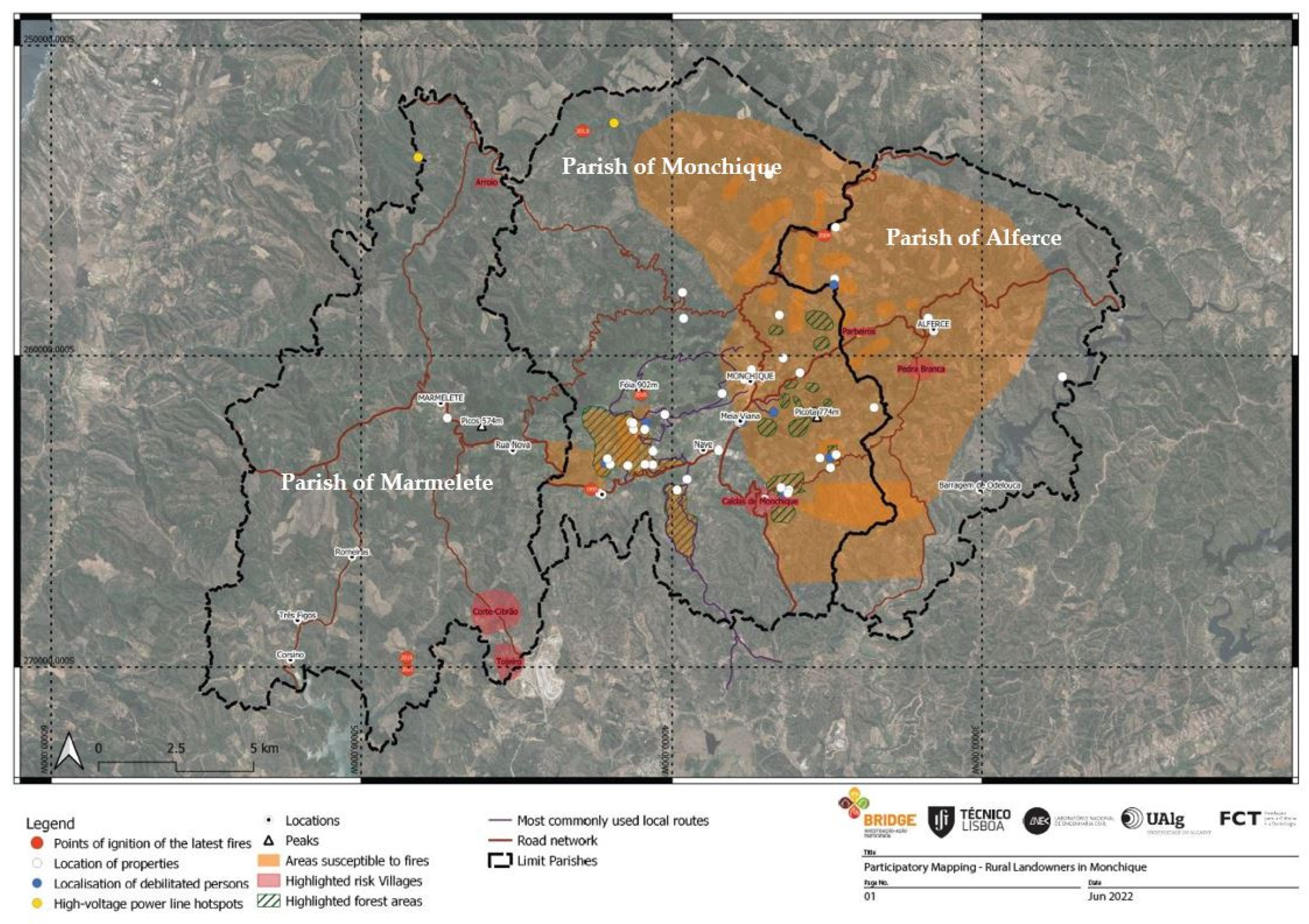
In relation to aspects of community life (step 2), the map presented in
Figure 6 illustrates the results obtained. In general, it is possible to observe that most participants live and/or own properties in the parishes of Alferce and Monchique, either around the urban center of the municipality of Monchique or dispersed in the rural areas to the east side of Monchique municipality (marked with white circles on the map). There are people more vulnerable to forest fires (e.g., children, elderly, people with reduced mobility, etc.), living in the seven houses marked with a blue circle, which represents 23.3% of the total houses identified by the participants.
Regarding the mapping of forest territories with interest and/or relevance (highlighted forest areas in green stripes), the participants marked two significant forest areas to the southwest of the urban center, and forest fragments around Monchique urban center, dispersed in the east and south of Monchique parish. It is noteworthy that, although the most relevant forest areas identified were within or around the landowners’ properties, participants agreed that forests occupy much of the territory of Monchique and that all have economic, environmental, and landscape importance for the municipality.
When asked to identify the local access roads mostly used by the landowners (identified by purple lines), the landowners identified a specific rural road at the west of the municipality’s urban center (due to its larger width the highest traffic circulation. Two other relevant local roads were marked on the map as being relevant: (i) one linking the urban center and the rural area to the west of the municipality and (ii) another that ensures access between the national road EN267 and the municipality of Portimão, (linking Monchique to the south). This information is considered relevant as it can contribute to prioritizing intervention activities that aim to improve Monchique’s most used rural accesses and safety. It is also important to highlight that improving such accessibility would also contribute to increasing the rural resident’s capacity to reach the safety points and ensure better and secure circulation of residents to shelters during the occurrence of a fire event.
During the identification of prone areas to forest fires, local risk factors, and vulnerabilities (step 3), an extensive risk area was marked in orange in Monchique’s eastern region (including around Monchique urban center). This area corresponds to the territory that burned in previous fires (2003 and 2018) and that, in the perception of the landowners, still represents a high risk of forest fires today. Two other expressive risk areas were identified to the southwest of the urban center, also in orange color, and two rural localities (Corte-Cibrão and Tojeiro) were highlighted with red as areas of high fire risk where three fire occurrences have been registered in the last five years.
The main risk factors and vulnerabilities of Monchique territory to forest fires highlighted by workshop participants, as a result of step 3, include:
Aging population and depopulation of rural areas with reduced social capital available for forest management.
A significant number of isolated and dispersed housing in rural areas (where according to the landowners, the 2018 fire burned a total of 1.800 isolated buildings).
Abandoned properties with old eucalyptus plantations (e.g., planted in the 1980s) with high volumes of flammable material without proper fuel management by the landowner (indicated as the main fire risk area).
Poor rural roads, make it difficult to access land for cleaning up forest remnants (organic materials), with contributions to the abandonment of isolated properties and heightens risks in the context of forest fires (participants specifically mentioned that eucalyptus trees along rural roads can “close” access, block escape routes and isolate homes).
Difficulty in managing private forest areas given the high cost of removing fuels due to lack of access, steep slopes and/or to the loss of productive capacity associated with low profitability in forest production.
Power lines crossing eucalyptus forests with risk of ignitions, combined with low maintenance levels and a lack of clearing by the responsible agencies. Notably, in some cases, low voltage electricity lines were made without prior consultation with the landowners, who in turn are responsible for maintaining the service tracks; some landowners do not have the resources to do this maintenance.
Absence of a biomass power plant in Monchique for wood and waste disposal. The closest biomass power plant is 150 km away making it too costly and unviable for landowners in Monchique.
The inaccessibility of water points and reservoirs in Monchique. Most of them are located in places with difficult access and/or in low-altitude areas (with little water pressure). In addition, pipes are not buried and melt with the heat of the fire, making it unfeasible to use de water from the reservoir in the context of forest fires.
The current plans, policies, and programs for the planning and management of Monchique forest territory “do not work”, because they are unsuitable to the specificities of the local reality, disconnected from the expectations of the landowners while imposing several constraints that seem to contribute to the abandonment and depopulation of rural areas.
Finally, it is interesting to note that the participants took the initiative to identify the ignition points of the latest forest fires in Monchique. This was followed by a collective debate on the causes of the spread of the 2018 fire, with two important aspects mentioned: (i) the topography of Monchique, namely the concave shape formed by the two highest geographical points in the Algarve (Foia and Picota) which funnels strong winds and the spread of fire and (ii) a set of mistakes, that in the landowner’s perspective occurred during suppression and firefighting, resulting in the spread of the fire and greater local impacts.
The result of the collective debate on forest fire risk reduction promoted during the participatory mapping with the Monchique landowners (step 4), includes seven strategic measures to minimize the risk of new fires and enhance the local adaptive capacity:
Carry out an in-depth study to evaluate if the landowners have the needed conditions and capacities to manage their forest areas, favoring other uses and occupations in those properties that lack conditions, or are abandoned, thus heightening the risk of fire.
Assess the current conditions of water points and reservoirs and promote actions to ensure access by landowners in the occurrence of forest fires (e.g., improving access roads, burying pipes so they do not melt during a fire, etc.).
Install forest fire monitoring posts at strategic locations in the Serra de Monchique.
Re-evaluate the policies, plans, and programs regarding the planning and management of Monchique forest territory, proposing revisions to fit them to the specificities of each territory and the expectations of rural landowners.
Require companies that rent private land for forest production to present a detailed plan with a resource allocation (deposit) for land recovery after forest production is concluded.
Build a biomass plant in Monchique to enable wood processing and removals from land clearing and resolve administrative issues that currently impede the availability of the wood chipping machine purchased by CMM after the 2018 fire.
Create a firefighting certificate addressed to landowners, ensuring their right to remain in the property to help fight the fire. This certification would be obtained after inspection of the property by the authorities attesting the conditions and resources needed to defend the housing/property in a fire context.
In addition to the data spatialized in the participatory map (
Figure 6), the workshop sessions collected local and valuable information that resulted from the reflection and debate between the Monchique landowners. Such information and data were analyzed, systematized, and integrated into the BRIDGE Project Internal Technical Report and the GIS Database to be used, in the future, by the local government and scientific community, contributing to (re)direct local strategies for forest fire risk reduction by incorporating local knowledge and landowners’ expectations from a bottom-up perspective.
4. Discussion and Conclusions
The experience of participatory mapping with Monchique landowners provides important lessons on the potential contribution of participatory mapping in CBDRR processes when managing forest fires. The results achieved support the relevance of valuing local landowners’ experiences, practices, and knowledge in forest fire management [
4,
5,
9,
10] related to its specific context [
8,
14]. This (i) increases the understanding of local risks and vulnerability [
8] and, (ii) (re)direct strategies focused on forest fire risk reduction tailored to local contexts, combining different local strategic paths [
8,
11,
17] that are aligned with communities’ expectations, facilitating their engagement and active role in these strategies [
9,
18]. The involvement of landowners with different characteristics and distinct interactions with the forest territories of Monchique also contributed to identifying and recognizing the diversity of knowledge, perceptions, and local actions on forest fire risk [
16,
17] inherent to the complexity of local context and dynamics, structural conditions and, social characteristics [
8,
14,
17]. It is important to point out that the collected body of information portrays the perspective of the landowners participating in the participatory mapping (bias) and, thus, does not represent the view of the entire local landowners’ community.
The results demonstrate the importance of involving land and forest owners, perhaps the most directly affected stakeholders by fires (losses, damage, etc.), and who have valuable know-how about local forests, in contributing to guiding policies and programs that are appropriate to the local context [
19]. Landowners are responsible for managing private forest areas in Portugal [
2] and should be the first in line to promote and adopt good practices in reducing the vulnerability and risks of forest fires by developing individual, but also, collective protective measures [
7], namely fuel management interventions [
16]. Noteworthy that Portugal has 84% of its forest area owned by private landowners [
1] and, thus, this investigation reinforces the need to recognize the vision, expectations, and interests of forest owners, and especially to promote their active role in risk reduction and integrated forest fire management [
20,
21].
The database that resulted from the participatory mapping with Monchique landowners will be available for consultation and use by local governments, forestry technicians, and scientists [
28]. With this, we hope to contribute ideas and inputs that can be used in the review of Monchique’s current plans, programs, and policies, to re-address and re-orient key policies related to land management and co-responsibility concerning forest fire risk reduction [
30,
31], for example, the Municipal Forest Defense and Fire Fighting Plan—PMDFCI [
36] or other relevant territorial development plans (e.g., Municipal Master Plan, Landscape Management and Recovery Plan). This is particularly important as it incorporates local knowledge and expectations of local communities which increases the potential for their collaboration in policy implementation [
9,
18].
In order to address the limitations of participatory mapping previously identified, namely the reliability of the collected data and its credibility [
32], we have chosen to (i) broaden the presentation of the obtained results beyond a representation on the map, also highlighting the results of the debates and collective reflections promoted in the workshops and (ii) present the information provided by the participants without any scientific lens “filter” (e.g., scientific validation of the risk factors or risk reduction measures proposed by the participants). Such strategies aimed to ensure that this database resulting from the participatory mapping represents, as faithfully as possible, the vision of the landowners involved and is therefore recognized and validated by themselves as their expression about the territory and recognized by the local governments and scientific community as such.
In addition to its importance as a source of locally based data, participatory mapping is a valuable social practice [
27] involving the landowner community of Monchique. Based on the interpretation of the map the collective debate was encouraged as well as the sharing of knowledge and experiences among the participants, about the main local risk and vulnerability factors. This has led to a reflection on possible local strategies on how to strengthen the territory and adaptive capacities in terms of forest fire risk reduction. It acted as an opportunity to encourage social learning and new practices [
30] about forest fires in Monchique, broadening local understandings of forest territories since different perspectives were cross-related and debated. The common ground shared by landowners on issues related to local risks and vulnerabilities, and the debate on local adaptive capacities to forest fires, contribute to increasing local awareness of fire risk and the appropriate measures to reduce this risk, strengthening fire-adapted communities (FACs) [
11,
12].
We believe this experience, and the set of workshop discussions may contribute to boosting a CBDRR process on forest fires in Monchique. To extend the positive results and benefits of participatory mapping in CBDRR processes, we highlight the following learning points and future actions: (i) broaden the involvement of local stakeholders, including different social groups and other forest users (e.g., hunting clubs, caravan owners, etc.), to ensure the coverage of different views about the forest territories in Monchique; (ii) enable the engagement of various local publics and key actors in the process of social learning about forest fire risks, vulnerabilities, and risk reduction measures; (iii) broaden the knowledge and experiences collected with the involvement of other social groups and integrate it into the GIS database; (iv) strengthen the CBDRR process stimulating and facilitating other participatory moments in Monchique. Such learning points aim to encourage the adoption of participatory mapping in CBDRR processes in other contexts of forest fire risk areas in Portugal and elsewhere and, most importantly, to contribute to addressing current gaps through approaches and actions that incorporate and value the knowledge and voices of local communities [
10,
13].
As a last point of reflection, it is important to highlight that the practice of participatory mapping represented a strategy to stimulate the mobilization and engagement of the landowner community, placing them in an active role in the debate on forest fire risk reduction in Monchique. However, there is a need to integrate the practice of participatory mapping with other community-based methodologies (e.g., community risk assessment methods) in order to broaden the results in terms of local agencies and collaborative networks for the integrated management of forest territories with a focus on fire risk reduction. In the context of the BRIDGE project, participative mapping was developed under the Innolab framework and represented the first of a series of participative initiatives and events planned to be developed over the next year with local communities and organizations in Monchique.

 ,
, 


