
Fluvial Morphology in Different Permafrost Environments—A Review

Department of Earth Sciences, Vrije Universiteit Amsterdam, De Boelelaan 1085, 1081 HV Amsterdam, The Netherlands
Quaternary 2024, 7(1), 15; https://doi.org/10.3390/quat7010015
Submission received: 20 December 2023
/
Revised: 13 February 2024
/
Accepted: 1 March 2024
/
Published: 15 March 2024
Abstract
:This review presents a synthesis of the interaction between the hydro-morphological processes on interfluves and channels within fluvial catchments in permafrost regions. Both in modern and ancient permafrost catchments, this integrated landscape is quite diverse because of a variegated extent of frozen ground, density of vegetation cover, snow thickness, and other local factors. Moreover, temporal changes in environmental conditions are expressed in the morphological evolution of catchments. Channel patterns vary between single- and different multi-channel forms while the interfluves show a high diversity ranging from complete stability to intense denudation by surface runoff. It appears that braided channels, despite their high energy, were only significant during short intervals of peak discharge and transported only limited amounts of eroded sediment, while other channel patterns required more subdued annual discharge variability. Further, denudational processes on interfluves were a specific characteristic of landscape evolution during subsequent ice ages, especially in conditions of snow-rich and poorly vegetated, seasonal frost, or discontinuous permafrost resulting in the formation of extended planforms (cryopediments). In contrast, interfluves appeared to be rather stable on continuously frozen soils.
1. Introduction
In general, fluvial morphology is manifestly the result of processes in different catchment components: (1) a linear stream pattern and (2) surface processes on the inter-channel slopes. Originally, these two landforms were studied and interpreted separately although both were occurring under the same environmental conditions and hydrological processes. However, a more holistic approach to the fluvial system is required, connecting the processes on interfluves and valleys. Since individual case histories have been reported frequently in the past, it is useful and timely now to assemble in a review the available hydro-morphological information from all parts of catchments. We limit this review to lowlands and rolling landscapes in permafrost environments and base our ideas on field palaeo-data from the last ice age and on analogies with present-day morphological and hydrodynamic conditions (e.g., [1,2]). We focus on permafrost regions where snow melt and frozen soils have traditionally been held responsible for high peak discharges with considerable sediment transport. In those regions, the role of running water has mainly been concentrated on channel processes; however, restricting fluvial morphology to the stream channel domain is a much too narrow perspective. River channels are only operational over their alluvial zone of several tens of meters or a few kilometers at the most, while interchannel overland flow widely plays an often overlooked role in shaping the landscape by surface transport and subsequent denudation.
Channel morphology in periglacial environments has generally been considered of the braided-river type, while correlative deposits have been assumed to be heterogeneous and coarse-grained [3] for a literature overview see [4]. However, it was demonstrated from present-day and past environments that this is an oversimplified picture since the periglacial river patterns range broadly from single- to multi-channel or from braided to meandering and anastomosing [1,5,6]. The interfluves were often shaped by—apart from mass movements and eolian activity—the intense activity of basin-wide overland flow resulting in the formation of planform denudational surfaces called cryopediments [7].
Thus, a more holistic approach to the fluvial system in permafrost environments is required to connect the processes on interfluves and valleys. In that respect, it should be kept in mind that permafrost regions are far from homogeneous [8]. Not only does their spatial continuity vary from continuous to discontinuous or sporadic but they are also characterized by a variety of climatic conditions (e.g., snowfall, seasonality) and by vegetation covers from dense taiga to tundra and bare deserts. Thus, one should address the specific environmental and hydrological conditions that instigated the development of observed periglacial morphology of both valleys and interfluves that prevailed in different kinds of frozen soil.
In the present review, we suggest a conceptual model for an integral fluvial morphological development under different permafrost distributions. More particularly, we differentiate climatic conditions and subsequent frozen-soil state between very cold (initiating continuous permafrost) and relatively less severe conditions (with discontinuous permafrost), referring to the modern High Arctic and Subarctic environments, respectively. In addition, we consider the varying vegetation cover, soil frost, and snow thickness. Generalizing, highly variable energy conditions determined the specific river pattern and sedimentary architecture [2,5]. On the interfluves, the present results illustrate the evolution from the Late Pleistocene initially non-permafrost to fully developed (continuous) permafrost and from full permafrost until degradation (with discontinuous or absent) permafrost generating different responses of hydrodynamic and morphological activity.
2. Overview of Hydrodynamic Drainage and Environmental Conditions in Modern Permafrost Catchments
On the whole, precipitation is low for most sites with continuous permafrost in the Arctic, while the Subarctic with discontinuous permafrost has higher precipitation. Snow is the principal form of precipitation in both areas but the percentage of rain increases towards the discontinuous permafrost zone [9]. Summer storms can bring strong wind and intense rainfall both to the Arctic and the Subarctic.
2.1. The Zone of Continuous Permafrost
Vegetation is sparsely distributed on many interfluves, which show a characteristic outlook, especially by the general, relatively thin snow cover as the exposed land favors snow drifting [10]. The few amounts of snow are swept away by the wind, often resulting in a barren desert environment [11]. With very low hydraulic conductivity, permafrost is regarded as practically impermeable. The active layer is thin, usually between 0.2 and 0.5 m depending on location and soil factors. As a result, overland flow is a general and immediate process as the impermeable permafrost table is near the surface but the discharge quantities remain low. Consequently, sediment removal is also relatively reduced. Morphological processes are not very different when the taiga forest is dominant (e.g., Siberia) and also limits surface runoff.
Snow is mainly accumulated and redistributed in sheltered locations such as depressions and valleys, for instance in the valleys or at the valley margins (Figure 1). This has a preponderant impact on the hydrology and morphological processes [12]. Snow-breakup, lasting for only a few weeks, represents the main constituent of the annual river discharge [13], while the contribution of groundwater to channel flow is practically zero [14]. Snow-breakup occurs quickly after temperatures rise above zero in spring, thus when the active layer is still thin and the channel banks are still protected by ice and snow. This means infiltration in the still-frozen subsoil is low and the intensity of the peak river discharge is high [9,15]. Rainfall is low to absent in summer so the annual hydrograph shows typically one general maximum in spring [9,16]. River discharge may be shortly interrupted by temporarily damming the valley by snow dams.
A specific relief develops on interfluves with large amounts of ice in the topsoil at the time of ice melting. Meltwater forms preferentially on top of ice wedges from where it may flow downslope, entraining some sediment from the sides of the troughs above the ice wedges [17]. This process may lead to the formation of local gullies that follow the pattern of the ice-wedge polygons. In addition, some regions contain exceptionally high amounts of ice in the topsoil, leading to general thaw subsidence and ultimately the development of vast thermokarst depressions, termed ‘alas’, for instance, in Siberia [18].
2.2. The Zone of Discontinuous Permafrost
As precipitation is higher than in the continuous permafrost zone, vegetation can more easily invade the interfluves leading to the development of a tundra or taiga vegetation covered with trees and shrubs in summer. The active layer in the Subarctic zone is overall thicker than in the High Arctic and absorbs higher amounts of melt- and rainwater. Large amounts of meltwater, derived from snow melting and thawing of the ice-rich upper zone of permafrost, flow from the interfluves towards the valleys as surface runoff at snow-breakup in spring, and afterward in summer on top of residual permafrost or winter-frozen subsoil. Thus, variable but extensive surface runoff on the interfluves can transport the sediments from the thawed surface, especially from poorly vegetated surfaces, in a dense network of tiny rills or a kind of sheetflow towards the main rivers before subsoil thawing [16].
Due to the absence of a continuously distributed permafrost, hydrology is different from the High Arctic zone. For instance, it is characterized by the frequent occurrence of icings [19]. Icings may dam the river flow and in such a case give rise to invasion of the floodplains at ice breakup, leaving behind planar sediment sheets [20]. Apart from their main peak at snow breakup, hydrographs of Subarctic rivers may show secondary summer peaks due to ice-jam breakup and summer rainstorms [21].
The role of groundwater in support of the baseflow in rivers increases as the amount of permafrost diminishes. Mackay and Loken [14] gave a rough estimate that groundwater contributes to less than 10% of streamflow in continuous permafrost areas but increases to 20–40% where permafrost is discontinuous. Supra-permafrost groundwater may drain along soil pipes that are hollow tubes measuring centimeters to over a meter in diameter [22,23]. The collapse of pipe roofs gives rise to rills. Together, the interchanging pipes and rills constitute a miniature flow network that delivers water and sediments more efficiently than by matrix flow. In permafrost terrain, frost cracks facilitate the formation of gullies when rain, snow, and wedge-ice meltwater exploit and enlarge the cracks [24]. Gullies may become rivulets as downcutting and slumping of the walls enlarge the channels.
Surface runoff, sustained by the melting of snow and ice, is an effective agent that transports thawed materials during the snowmelt season. Summer rain may saturate and wash large quantities of thawed materials and thus raise or revive the surface flow. Overland flow is prominent on frozen ground on interfluves devoid of vegetation [2]. The flow occurs preferentially in sheets of water, carrying the eroded sediments in suspension. A mixture of water and snow can also move as slush [25,26]. Surface runoff also concentrates in channels that vary in size from rills to trench-like gullies [4,12]. Conditions and processes in poorly vegetated interfluves result in widely distributed sediment entrainment and planar denudation (Figure 2). The topographic gradient of such planar surfaces towards the main river thalwegs is gently sloping. Their spatial extents vary between a few hundred meters and some kilometers and were originally well-documented from Siberia [7,18], and recently reviewed [27]. Similar forms were originally defined in hot deserts and termed pediments but were later also recognized in cold regions where they are called ‘cryopediments’. They are the result of planar erosion, which leaves only shallow, sheet-like channels and rill deposits unconformably overlying the substratum.
Although all processes described in this section may also occur occasionally in conditions of continuous permafrost, it follows from the hydro-morphological analysis that they developed preferentially under discontinuous permafrost. Finally, it should be stressed that the presented analysis focuses on lowlands with gentle slopes where mass-transport processes were of minor importance.
3. Morphology and Sedimentology of Channel Systems in Modern and Ancient Permafrost Areas
Vandenberghe [5] and Vandenberghe and Woo [1] identified different kinds of channel morphology and correlative sedimentary facies as a function of vegetation and frozen subsoil conditions and compared modern and ancient systems. For the more recent literature, one is referred to [6]. A short summary is given below (see also Table 1).
3.1. High-Energetic Systems
Although precipitation is low in most continuous permafrost areas, there are eight or more months of sub-freezing temperatures during which the fallen snow does not melt but accumulates in the interfluve and valley zones. The bulk of snow stored in the winter months undergoes rapid melt in the spring when temperatures rise above freezing and incoming radiation reaches the snow up to 24 h each day. A thin active layer, usually 0.2–0.5 m, gets easily saturated. Surface flow is favored by a frozen substrate that restricts infiltration; however, with low precipitation in most of the Arctic, the amount of runoff is low. As a result, sediment removal is also relatively reduced. With limited infiltration, most of the meltwater quickly reaches the valley, inducing peak flows [2]. As the snow continues to be depleted, river flow recedes to a summer low, unless boosted by occasional rain. Eventual arrival of winter terminates streamflow, leaving a dry riverbed and a river valley that collects drifting snow [29]. This seasonal flow rhythm, named by Church [13] as the Arctic nival regime, has a large, high flow in spring to flush the stored deposits in the channel and the new sediments brought in by surface flow from the interfluves.
Traditionally, braided-river patterns have been considered most typical for a wide range of frozen-soil environments after snow-breakup and in poorly vegetated areas (Figure 1). They are reported from numerous Pleistocene glacial periods (references for instance in [6,30]). Characteristics of this channel type are the high-energetic conditions, especially during snow-breakup [5]. They are most typical for but not exclusively in regions of continuous permafrost. The sedimentary architecture of braided systems is characterized by cut and fill channel deposits with trough-cross-bedded, relatively coarse-grained, and heterogeneous clasts, which were deposited as bedload (Figure 3). They alternate with planar-(sub)horizontal sheets that often occur on top or on the flanks of banks between the channels and in the marginal zones of the braidplain [12,31,32].
The sediment transport capacity is high and large blocks may be transported during the short event of snow-breakup. Clasts up to a half m3 were reported [29]; however, only limited amounts of sediment are transported and deposited in thin and heterogeneous beds. This is explained by the thin or even non-existent active layer at the time of snow-breakup. In general, permafrost with ice-wedge polygons often develops atop inactive channels and bars of the floodplain [33]. Thus, fluvial transport is sediment-limited although the erosive capacity is temporarily high.
Occasionally, river water tends to undercut banks, followed by soil collapse or slides, by creating thermo-erosional niches, especially in ice-rich soils and warming conditions (e.g., [34,35,36]). But, in general, such thermal erosion is of local impact and not able to entrain large amounts of sediment. In contrast to the frequent occurrence of snow dams in the valleys, almost no ice dams and icings occur in the High Arctic. This is because the rivers are largely frozen during winter and only a limited amount of unfrozen water is flowing below the river ice. In addition, there is only weak water feeding from the neighboring slopes due to the shallow active layer.
3.2. Channels of Moderate-to-Low Energy
In some regions, braiding could be hindered by limited availability of sediment load or by locally reduced runoff due to low amounts of winter snowfall or densely vegetated land surface [37]. Under such conditions, a braided pattern is only present at the beginning of breakup when discharges are highest, and vegetation is not well-developed. The braided pattern may be substituted by a multi-channel anabranching system with stable islands and individual channels where tundra or taiga vegetation restricts sediment supply [1]. Typical examples may be mentioned from the Holocene Usa River in north Siberia [38] and the modern lower/middle Lena River in east Siberia [39] (Figure 4).
The Subarctic of North America and the Siberian taiga have broad extensions of wetlands, mostly underlain by peat with high water storage capacity and characterized by ponds and depressions that detain or store surface water. After a cold winter, wetlands stay frozen at the time when snowmelt commences. The abundance of ice in the frozen soil and on the surface limits infiltration of the ample meltwater, thus, the surface water produces spring high flows in the river. As summer progresses, however, the peat becomes desiccated and many ponds dry out, raising the capacity of the wetland to absorb rainwater and withhold it from outflow. Discharge from the wetland then has subdued peaks, and gradual drainage of the wetland extends the recession flow in this wetland regime [40]. The anabranching channel pattern is typical for this wetland regime, with a relatively steady meltwater supply from the active layer or groundwater and a limited supply of coarse sediment [1]. It resembles the stable ‘wandering gravel-bed rivers’ described by [3,41]. It contrasts with the more classical anastomosing type characterized by lateral migrating (meandering) channels with frequent avulsions, occasional point-bars and erosive concave banks [42], and many transitional systems occur. In most of the multi-channel systems, there are a few large active channels next to many channels that are only periodically active [43].
Favorable conditions for the development of well-developed marshy flood basins with anabranching or anastomosing systems occurred in the past, for instance, during snow-rich periods in the Pleistocene tundra of north and central Europe, with long seasonal frost [44,45]. They look similar to the modern Subarctic wetland systems by their avulsions and adjacent shallow lakes for much of the year. Sandy bars and channel fills alternate with crevasse splays, while gyttja and organic and sandy-silty beds of reworked loess fill the marshy backswamps (e.g., [33,46,47]). Inactive subaerial beds were frozen and disturbed by a range of cryogenic structures, including ice-wedge and frost fissure polygons, while in phases of re-activation, the thawed subsoil was prone to cryoturbation (e.g., [31,33,45,47,48]).
Meandering rivers, often with large wavelengths and amplitudes, are not uncommon in the modern permafrost regions of North America and Siberia (Figure 5). They are typical in taiga or densely vegetated landscapes with small sediment loads and/or reduced transport capacity due to a low longitudinal gradient [49,50,51]. The required cohesion of the marginal channel sediments for a meandering pattern is acquired by their fine grain size but may also be enhanced by the frozen state of the soil. In summary, surface flow is effective as an agent of erosion and the transport of sediments. The re-initiation of a vegetation cover (from continuous steppe to taiga) after the poor vegetation during the last glacial in Eurasia resulted in increased slope stability and a reduction in sediment supply to the rivers [52]. Paleo-meanders with remarkably large amplitude are a characteristic element of many of those former Pleistocene periglacial landscapes (e.g., [53,54]). They are similar to the large meanders in the present-day taiga region of north Siberia. The large meander amplitude is ascribed to very high maximum flood discharges caused by the rapid thawing of a thick snow cover in spring on top of the long seasonally frozen ground with limited soil infiltration [53]. The exact timing of large-meander initiation was regionally different depending on the speed of re-establishment of the vegetation after the last glacial maximum [50,51,53,55,56].
4. Overland Processes on the Interfluves during Pleistocene Times
Pleistocene cryopediments characterize, for instance, large parts of the modern Belgian–Dutch lowlands and the rolling landscape of Moravia (Czech Republic) (Figure 6A [57]. In the relatively flat topography of lowlands, only low energy was required to remove the relatively small amounts of fine-grained sediment. Thus, the gradients of the cryopediment, as the driving force for sediment removal, could be relatively small, from some tenths of a degree on top of erodible soft substratum (as in NW Europe) until a maximum of a few degrees on top of hardrock substratum (as in central Europe) [57]. At their distal ends, the cryopediments grade into river terraces or directly into valley floors. In contrast with the present-day drainage by meandering channels, sediment transport was by rillwash and a dense network of shallow gullying in the NW European lowlands, supplemented with mass movement in the hilly topography of Moravia [7,18,58]. Vertical erosion may progressively have extended towards the upslope ends of the drainage network by regressive erosion [18,59]. It was shown that progressive cryopedimentation during the Pleistocene resulted in a river terrace-like staircase, although younger cryopedimentation may have re-shaped ultimately former cryopediments [58].
All these processes required periodically high runoff that would have been impossible in permeable subsoils as, for instance in the Belgian–Dutch lowlands at present. The required high peak runoff discharges could only be generated by the meltwater of a fairly thick snow cover at springtime on an, at least seasonally, frozen substratum [62,63]. Conditions of deep seasonal frost were sufficient for their development. The High Arctic conditions of continuous permafrost were even less favorable as the intensity of denudational processes on the interfluves is relatively low due to the minor amounts of snow and the shallow active layer (see Section 2). On top of discontinuous permafrost or deep winter frost, a (short) high peak runoff was generated due to the rapid thaw of a thick snow cover on top of the still-frozen and sparsely vegetated substrate in spring. In addition, denudation by overland flow was more prominent than in the more severe conditions of continuous permafrost as relatively large amounts of thawed subsoil in spring were available. Cryopedimentation was, thus, a most important geomorphological process on the interfluves in discontinuous permafrost areas [58]. The evolution of the last permafrost period (c. 25–17 ka) in NW Europe is documented in the detailed and well-dated sedimentary records from that time (e.g., [27,33,60,64]). Just before the maximum of the last permafrost period (pre-LPM), conditions started with a discontinuous permafrost and distinct overland flow as manifested in the infill of a dense pattern of (braided) gullies (Table 2). This phase was followed (during the last permafrost maximum, LPM) by fully developed continuous permafrost as evidenced by the formation of numerous patterns of ice- and sand-wedge polygons, while fluvial activity decreased. After this maximum of cold (post-LPM), permafrost degraded resulting in the thaw of the ice in the wedges and the top of the permafrost resulting in the collapse and sedimentary fill of the wedges and the formation of cryoturbations (Figure 6B; Table 2). Finally, ice-wedge pseudomorphs and cryoturbations were truncated by renewed rill and gully erosion as at permafrost initiation. Both phases of gully erosion occurred during phases of fragmentary permafrost and were obviously also the phases of cryopedimentation. In contrast, the phase of maximum permafrost development was morphologically a period of relative stability.
5. Discussion and Synthesis: The Fluvial System in Conditions from Continuous to Degraded or Disappearing Permafrost
Understanding the catchment morphology in permafrost terrain requires considering both channel patterns and interfluves. As shown before (e.g., [1,5,6]), a full range of channel-pattern variability from braided to anastomosing or anabranching and (large) meanders was present as a function of intensity and distribution of frozen soil, regional patterns of vegetation cover, sediment availability, and snow thickness. High-energy conditions were proportionally more favorable for braiding on poorly vegetated and perennially frozen ground. A dense vegetation cover and thick snow mantles on discontinuous permafrost or seasonally frozen ground resulted also in anastomosed or single-channel patterns. In conditions of continuous permafrost, as in the High Arctic, fluvial activity was largely restricted to the valleys while interfluves with tundra vegetation or bare soils were dry and swept nearly free of snow by the wind. Such conditions with shallow active layers were unfavorable for surface runoff or any denudation, also when covered by taiga vegetation. In other words, interfluves were morphologically relatively stable in the zone with continuous permafrost.
Detailed reconstruction of sedimentary sequences and sediment dating on the interfluves with fragmented or absent permafrost and wide-mesh vegetation cover show that increased surface runoff and denudation resulted in cryopediment formation (Nyland et al. 2023). Typically, this hydro-morphological process occurred in the initial stage of permafrost development and during its degradation phase, as exemplified by the Belgian–Dutch border zone before and after the last Permafrost Maximum. It would be a misconception to attribute the formation of cryopediments to conditions of the coldest phases of a glacial period with the most severe (continuous) permafrost. In contrast, in conditions of discontinuous permafrost or deep winter frost, cryopedimentation was a most important geomorphological process on the interfluves. Frozen soil was not necessary for this morphological process [65], which means conditions of deep seasonal frost were sufficient for their development. The main requirement for their formation is a (short) high peak runoff after the rapid thaw of a thick snow cover on top of the still-frozen and sparsely vegetated substrate in spring, maybe in addition to some groundwater contribution. In areas with degrading ice-rich permafrost, thawing of the top of the frozen soil at that moment may also have enhanced the volume of surface runoff. Finally, the described diversity of processes and forms should be considered when evaluating the morphological changes that may be expected in the degradation of present-day permafrost [21,66].
Funding
This research received no external funding.
Acknowledgments
The paper benefitted substantially from extensive discussions and suggestions by Ming-ko Woo, Canada.
Conflicts of Interest
The author declares no conflict of interest.
References
- Vandenberghe, J.; Woo, M.K. Modern and ancient periglacial river types. Progr. Phys. Geogr. 2002, 26, 479–506. [Google Scholar] [CrossRef]
- Woo, M.K. Permafrost Hydrology; Springer: Berlin/Heidelberg, Germany, 2012; 564p. [Google Scholar]
- Church, M. Pattern of instability in a wandering gravel bed channel. In Modern and Ancient Alluvial Systems; Collinson, J.D., Lewin, J., Eds.; International Association of Sedimentologists, Special Publication: Brussels, Belgium, 1983; Volume 6, pp. 169–180. [Google Scholar]
- Clark, M.J. Periglacial hydrology. In Advances in Periglacial Geomorphology; Clark, M.J., Ed.; John Wiley and Sons Ltd.: Chichester, UK, 1988; pp. 415–462. [Google Scholar]
- Vandenberghe, J. A typology of Pleistocene cold-based rivers. Quat. Int. 2001, 79, 111–121. [Google Scholar] [CrossRef]
- Van Huissteden, J.; Vandenberghe, J.; Gibbard, P.L.; Lewin, J. Periglacial rivers. In The Encyclopedia of Quaternary Science, 3rd ed.; Elias, S.A., Ed.; Elsevier: Amsterdam, The Netherlands, 2023. [Google Scholar]
- Czudek, T. Kryopedimente–wichtige Reliefformen der rezenten und pleistozänen permafrostgebiete. Peterm. Geogr. Mitt. 1988, 132, 161–173. [Google Scholar]
- French, H.M. The Periglacial Environment, 4th ed.; Wiley: Chichester, UK, 2014. [Google Scholar]
- Woo, M.K. Permafrost hydrology in North America. Atmosphere-Ocean 1986, 24, 201–234. [Google Scholar] [CrossRef]
- Woo, M.K.; Marsh, P.; Steer, P. Basin water balance in a continuous permafrost environment. In Proceedings of the 4th International Conference Permafrost, Fairbanks, AL, USA, 18–22 July 1983; National Academy Press: Washington, DC, USA, 1983; pp. 1407–1411. [Google Scholar]
- Bird, J.B. The Physiography of Arctic Canada; Johns Hopkins Press: Baltimore, MD, USA, 1967. [Google Scholar]
- McCann, S.B.; Howarth, P.J.; Cogley, J.G. Fluvial processes in a periglacial environment. Trans. Inst. Br. Geogr. 1971, 55, 69–82. [Google Scholar]
- Church, M. Hydrology and permafrost with reference to northern North America. In Proceedings of the Workshop Seminar on Permafrost, CNC/IHD, Calgary, Alberta, 26–28 February 1974; Canadian National Committee for the International Hydrological Decade: Ottawa, ON, Canada, 1974; pp. 7–20. [Google Scholar]
- Mackay, D.K.; Løken, O.H. Arctic hydrology. In Arctic and Alpine Environments; Ives, J.D., Barry, R.G., Eds.; Methuen & Co., Ltd.: London, UK, 1974; pp. 111–132. [Google Scholar]
- Woo, M.K.; Pomeroy, J. Snow and runoff: Processes, sensitivity and vulnerability. In Changing Cold Environments, a Canadian Perspective; French, H.M., Slaymaker, O., Eds.; John Wiley and Sons: Chichester, UK, 2012; pp. 105–125. [Google Scholar]
- Woo, M.K.; Winter, T.C. The role of permafrost and seasonal frost in the hydrology of northern wetlands in North America. J Hydrol. 1993, 141, 5–31. [Google Scholar] [CrossRef]
- French, H.M.; Egginton, P. Thermokarst development, Banks Island, Western Canadian Arctic. In Permafrost, Proceedings of North American Contribution to the 2nd International Conference on Permafrost, Yakutsk, Russia, 12–20 July 1973; USSR, Publication 2115; National Academy of Sciences: Washington, DC, USA, 1973; pp. 203–212. [Google Scholar]
- Czudek, T.; Demek, J. Pleistocene cryopedimentation in Czechoslovakia. Acta Geogr. Lodz. 1970, 24, 101–108. [Google Scholar] [CrossRef]
- Goulding, H.L.; Prowse, T.D.; Beltaos, S. Spatial and temporal patterns of break-up and ice-jam flooding in the Mackenzie Delta, NWT. Hydrol. Process. 2009, 23, 2654–2670. [Google Scholar] [CrossRef]
- Reedyk, S.; Woo, M.K.; Prowse, T.D. Contribution of icing ablation to streamflow in a discontinuous permafrost area. Can. J. Earth Sci. 1995, 32, 13–20. [Google Scholar] [CrossRef]
- Woo, M.K. Consequences of climatic change for hydrology in permafrost zones. J. Cold Reg. Eng. 1990, 4-1, 15–20. [Google Scholar] [CrossRef]
- Carey, S.K.; Woo, M.K. The role of soil pipes as a slope runoff mechanism, subarctic Yukon, Canada. J. Hydrol. 2000, 233, 206–222. [Google Scholar] [CrossRef]
- Mitchell, R.J.; Nelson, F.E.; Nyland, K.E. Little tools, big job: The periglacial conveyor system in cryoplanated uplands. Permafr. Periglac. Process. 2013, 34, 384–398. [Google Scholar] [CrossRef]
- Fortier, D.; Allard, M.; Shur, Y. Observation of rapid drainage system development by thermal erosion of ice wedges on Bylot Island, Canadian Arctic Archipelago. Permafr. Periglac. Process. 2007, 18, 229–244. [Google Scholar] [CrossRef]
- Barsch, D.; Gude, M.; Mausbacher, R.; Schukraft, G.; Schulte, A.; Strauch, D. Slush stream phenomena-Process and impact. Zeitschr. Geomorph. 1993, 92, 39–53. [Google Scholar]
- Gude, M.; Scherer, D. Snowmelt and slush torrents-preliminary report from a field campaign in Kärkevagge, Swedish Lappland. Geogr. Ann. 1995, 77A, 199–206. [Google Scholar]
- Nyland, K.; Vandenberghe, J.; Nelson, F. Cryoplanation terraces and cryopediments. In The Encyclopedia of Quaternary Science, 3rd ed.; Elias, S.A., Ed.; Elsevier: Amsterdam, The Netherlands, 2023. [Google Scholar] [CrossRef]
- Vandenberghe, J.; French, H.M.; Jin, H.; Wang, X.; Yi, S.; He, R. The extent of permafrost during the Last Permafrost Maximum (LPM) on the Ordos Plateau, north China. Quat. Sci. Rev. 2019, 214, 87–97. [Google Scholar] [CrossRef]
- Woo, M.K.; Sauriol, J. Effects of snow jams on fluvial activities in the High Arctic. Phys. Geogr. 1981, 13, 83–98. [Google Scholar] [CrossRef]
- Bridgland, D.R.; Westaway, R. Quaternary fluvial archives and landscape evolution: A global synthesis. Proc. Geol. Assoc. 2014, 125, 600–629. [Google Scholar] [CrossRef]
- Bryant, I.D. The utilization of arctic river analogue studies in the interpretation of periglacial river sediments from southern Britain. In Background to Paleohydrology; Gregory, K.J., Ed.; Wiley and Sons: Chichester, UK, 1983; pp. 413–431. [Google Scholar]
- Miall, A.D. The Geology of Fluvial Deposits: Sedimentary Facies, Basin Analysis and Petroleum Geology; Springer: Berlin/Heidelberg, Germany, 1996; 582p. [Google Scholar]
- Kasse, C.; Vandenberghe, J.; Van Huissteden, J.; Bohncke, S.J.P.; Bos, J.A.A. Sensitivity of Weichselian fluvial systems to climate change (Nochten mine, eastern Germany). Quat. Sci. Rev. 2003, 22, 2141–2156. [Google Scholar] [CrossRef]
- Walker, J.; Arnborg, L.; Peippo, J. Riverbank erosion in the Colville delta, Alaska. Geogr. Ann. 1987, 69A, 61–70. [Google Scholar] [CrossRef]
- Costard, F.; Gautier, E.; Brunstein, D.; Hammadi, J.; Fedorov, A.; Yang, D.; Dupeyrat, L. Impact of the global warming on the fluvial thermal erosion over the Lena River in Central Siberia, Geophys. Res. Lett. 2007, 34, L14501. [Google Scholar] [CrossRef]
- Costard, F.; Gautier, E.; Fedorov, A.; Konstantinov, P.; Dupeyrat, L. An assessment of the erosion potential of the fluvial thermal process during ice breakups of the Lena River (Siberia). Permafr. Periglac. Process. 2014, 25, 162–171. [Google Scholar] [CrossRef]
- Woo, M.K.; Young, K. Hydrology of a small drainage basin with polar oasis environment, Fosheim Peninsula, Ellesmere Island, Canada. Permafr. Periglac. Process. 1997, 8, 257–277. [Google Scholar] [CrossRef]
- Huisink, M.; De Moor, J.J.W.; Kasse, C.; Virtanen, T. Factors influencing periglacial fluvial morphology in the northern European Russian tundra and taiga. Earth Surf. Process. Landf. 2002, 27, 1223–1235. [Google Scholar] [CrossRef]
- Gautier, E.; Dépret Th Cavero, J.; Costard, F.; Firmoux, C.; Fedorov, A.; Kostantinov, P.; Jammet, M.; Brunstein, D. Five-year dynamics of the Lena River islands (Russia): Spatio-temporal pattern of large periglacial anabranching river and influence of climate change. Sci. Total Environ. 2021, 783, 148020. [Google Scholar] [CrossRef]
- Woo, M.K. Wetland runoff regime in northern Canada. In Proceedings of the Fifth International Conference, Trondheim, Norway, 2–5 August 1988; Tapir Publishers: Trondheim, Norway, 1988; Volume 1, pp. 644–648. [Google Scholar]
- Nanson, G.C.; Knighton, A.D. Anabranching rivers: Their cause, character, and classification. Earth Surf. Process. Landf. 1996, 21, 217–239. [Google Scholar] [CrossRef]
- Smith, D.G. Anastomosed Fluvial Deposits: Modern Examples from Western Canada; Spec Publ Ass Sedimentol: Ghent, Belgium, 1983; Volume 6, pp. 155–168. [Google Scholar]
- Kasse, C.; Vandenberghe, J.; Bohncke, S. Climatic change and fluvial dynamics of the Maas during the Late Weichselian and Early Holocene. In European River Activity and Climatic Change during the Lateglacial and Early Holocene; Frenzel, B., Vandenberghe, J., Kasse, C., Bohncke, S., Gläser, B., Eds.; Paläoklimaforschung: New York, NY, USA, 1995; Volume 14, pp. 123–150. [Google Scholar]
- Van Huissteden, J. Tundra rivers of the Last Glacial: Sedimentation and geomorphological processes during the Middle Pleniglacial (Eastern Netherlands). Meded. Rijks Geol. Dienst 1990, 44, 1–138. [Google Scholar]
- Kasse, K.; Bohncke, S.; Vandenberghe, J. Fluvial periglacial environments, climate and vegetation during the Middle Weichselian in the northern Netherlands with special reference to the Hengelo Interstadial. Meded. Rijks Geol. Dienst 1995, 52, 387–414. [Google Scholar]
- Van Huissteden, J.; Vandenberghe, J. Changing fluvial style of periglacial lowland rivers during the Weichselian Pleniglacial in the eastern Netherlands. Zeitschr. Geomorphol. 1988, 71, 131–146. [Google Scholar]
- Mol, J. Fluvial response to Weichselian climate changes in the Niederlausitz (Germany). J. Quat. Sci. 1997, 12, 43–60. [Google Scholar] [CrossRef]
- Huisink, M. Changing river styles in response to Weichselian climate changes in the Vecht valley, eastern Netherlands. Sediment. Geol. 2000, 133, 115–134. [Google Scholar] [CrossRef]
- Sidorchuk, A.Y.; Panin, A.V.; Borisova, O.K. Climate-induced changes in surface run-off on the north-Eurasian plains during the Late Glacial and Holocene. Water Resour. 2008, 35, 386–396. [Google Scholar] [CrossRef]
- Sidorchuk, A.; Panin, A.; Borisova, O. Morphology of river channels and surface runoff in the Volga River basin (East European Plain) during the Late Glacial period. Geomorphology 2009, 113, 137–157. [Google Scholar] [CrossRef]
- Panin, A.V.; Matlakhova, E. Fluvial chronology in the East European Plain over the last 20 ka and its palaeohydrological implications. Catena 2015, 130, 46–61. [Google Scholar] [CrossRef]
- Vandenberghe, J.; Beyens, L.; Paris, P.; Kasse, C.; Gouman, M. Paleomorphological and -botanical evolution of small lowland valleys (Mark valley). Catena 1984, 11, 229–238. [Google Scholar] [CrossRef]
- Vandenberghe, J.; Sidorchuk, A. Large palaeomeanders in Europe: Distribution, formation process, age, environments and significance. In Palaeohydrology-Traces, Tracks and Trails of Extreme Events, Geography of the Physical Environment; Herget, J., Fontana, A., Eds.; Springer Nature: Basel, Switzerland, 2020; pp. 169–186. [Google Scholar]
- Panin, A.; Borisova, O.; Belyaev, V.; Belyaev, Y.; Eremenko, E.; Fuzeina, Y.; Sheremetskaya, E.; Sidorchuk, A. Evolution of the Upper Reaches of Fluvial Systems within the Area of the East European Plain Glaciated during MIS 6. Quaternary 2022, 5, 13. [Google Scholar] [CrossRef]
- Bertran, P.; Frouin, M.; Mercier, N.; Naessens, F.; Prodeo, F.; Queffelec, A.; Sirieix, C.; Sitzia, L. Architecture of the lower terraces and evolution of the Dordogne River at Bergerac (south-west France) during the last glacial–interglacial cycle. J. Quat. Sci. 2013, 28, 605–616. [Google Scholar] [CrossRef]
- Turner, F.; Tolksdorf, J.F.; Viehberg, F.; Schwalb, A.; Kaiser, K.; Bittmann, F.; von Bramann, U.; Pott, R.; Staesche, U.; Breest, K.; et al. Lateglacial/early Holocene fluvial reactions of the Jeetzel river (Elbe valley, northern Germany) to abrupt climatic and environmental changes. Quat. Sci. Rev. 2013, 60, 91–109. [Google Scholar] [CrossRef]
- Vandenberghe, J.; Czudek, T. Pleistocene cryopediments on variable terrain. Permafr. Periglac. Process. 2008, 19, 71–83. [Google Scholar] [CrossRef]
- Vandenberghe, J.; Kasse, K. Cryopedimentation on soft-sediment subsoils. Würzburger Geogr. Arb. 1993, 87, 283–297. [Google Scholar]
- Demek, J. Kryopedimenty: Jejich vznik a vývoj (Cryopediments, its origin and development). Scr. Fac. Sci Nat. Univ.—Purkynianae Brun. 1980, 10, 221–231. [Google Scholar]
- Van Huissteden, J.; Vandenberghe, J.; Van der Hammen, T.; Laan, W. Fluvial and aeolian interaction under permafrost conditions: Weichselian Late Pleniglacial, Twente, eastern Netherlands. Catena 2000, 40, 307–321. [Google Scholar] [CrossRef]
- Vandenberghe, D.; Derese, C.; Kasse, C.; Van den haute, P. Late Weichselian (fluvio-)aeolian sediments and Holocene drift-sands of the classic type locality in Twente (E Netherlands): A high-resolution dating study using optically stimulated luminescence. Quat. Sci. Rev. 2013, 68, 96–113. [Google Scholar] [CrossRef]
- Thorn, C.E. The geomorphic role of snow. Ann. Assoc. Am. Geogr. 1978, 68, 414–425. [Google Scholar] [CrossRef]
- Ballantyne, C.K. The hydrologic significance of nivation features in permafrost areas. Geogr. Ann. 1978, 60, 51–54. [Google Scholar] [CrossRef]
- Vandenberghe, J.; Van Huissteden, J. Fluvio-aeolian interaction in a region of continuous permafrost. In Proceedings of the 5th International Conference on Permafrost, Trondheim, Norway, 2–5 August 1998; Tapir Publishers: Trondheim, Norway, 1998; pp. 876–881. [Google Scholar]
- French, H.M.; Harry, D.G. Pediments and cold climate conditions, Barn Mountains, unglaciated northern Yukon, Canada. Geogr. Ann. 1992, 74A, 145–157. [Google Scholar] [CrossRef]
- Lininger, K.B.; Wohl, E. Floodplain dynamics in North American permafrost regions under a warming climate and implications for organic carbon stocks: A review and synthesis. Earth Sci. Rev. 2019, 193, 34–44. [Google Scholar] [CrossRef]
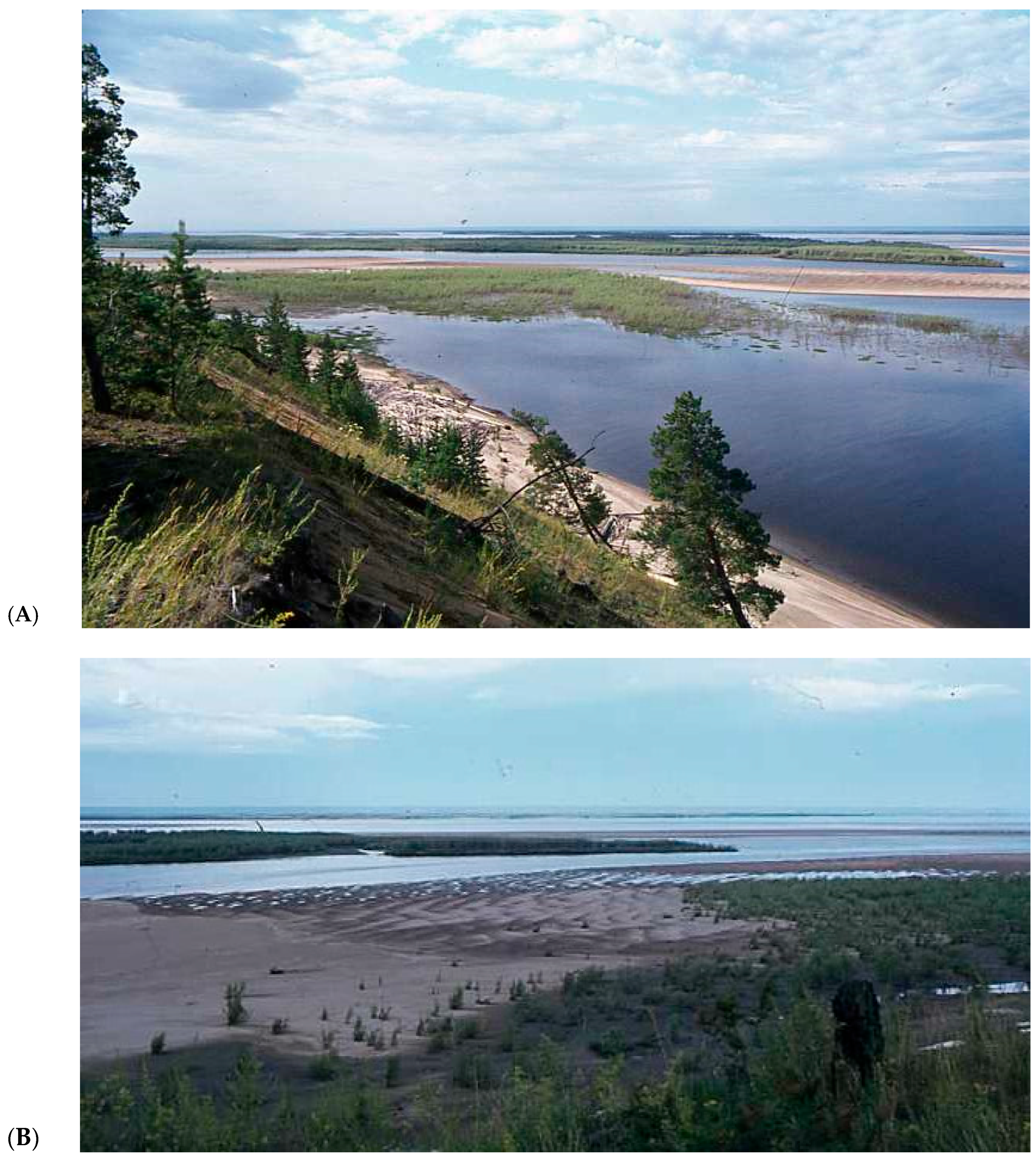
Figure 1.
Braided river at Eureka (north Canada) with distinct snow accumulation at the valley margins and within tributary valleys.
Figure 1.
Braided river at Eureka (north Canada) with distinct snow accumulation at the valley margins and within tributary valleys.

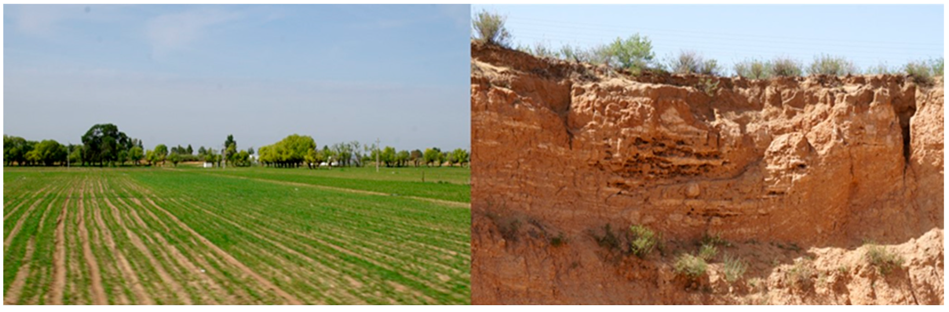
Figure 2.
(Left) Cryopediment on the central Ordos Plateau (15 km south of Wusheng, north China); (Right) associated planar sheetwash deposits superposed by up to 1,5-m deep sand wedges that are indicative for post-sedimentary permafrost [28].
Figure 2.
(Left) Cryopediment on the central Ordos Plateau (15 km south of Wusheng, north China); (Right) associated planar sheetwash deposits superposed by up to 1,5-m deep sand wedges that are indicative for post-sedimentary permafrost [28].

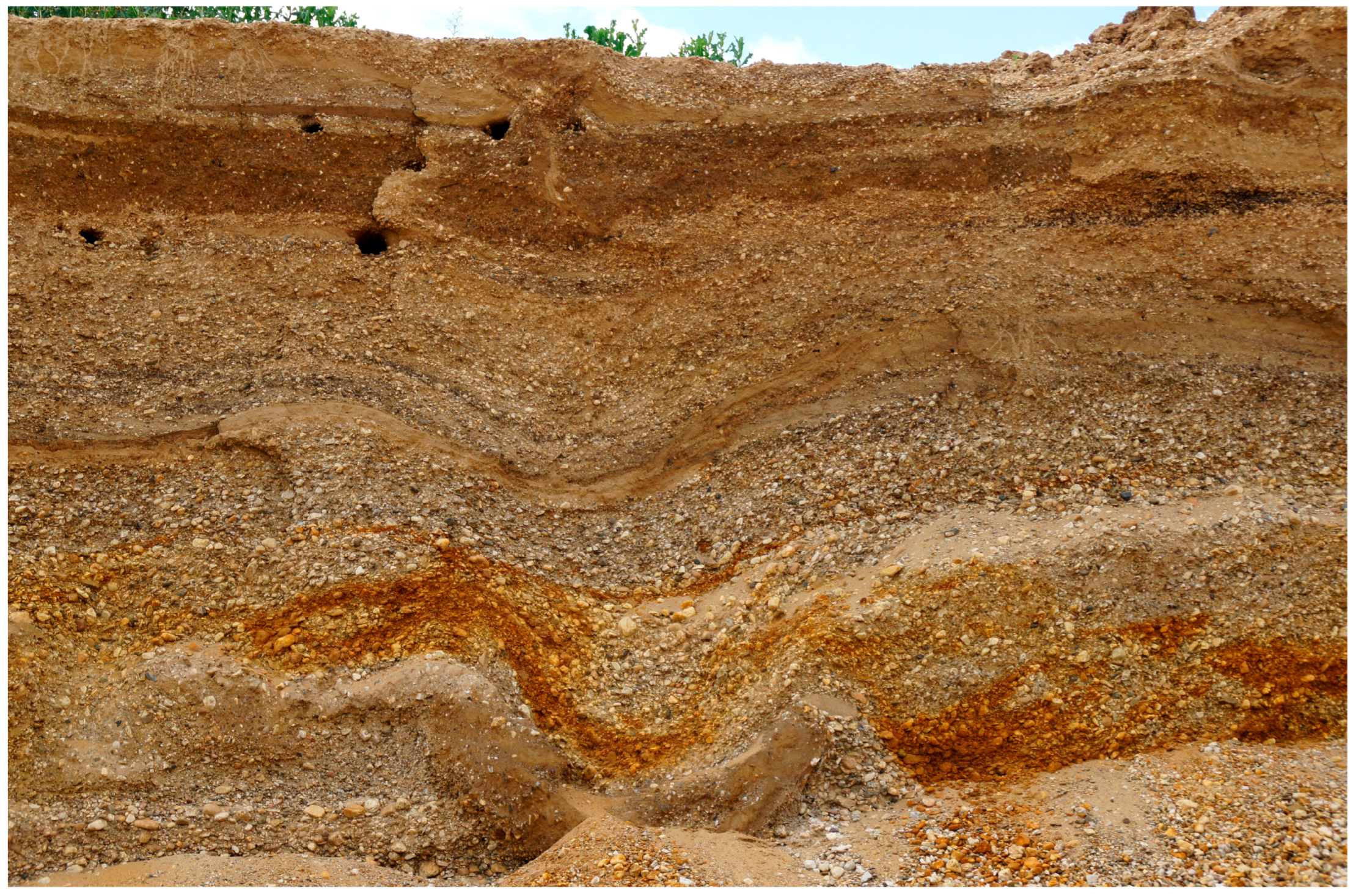
Figure 3.
Typical braided-river gravel deposits with high-amplitude cryoturbation (>1 m), penultimate glacial stage, Rehbach, east Germany.
Figure 3.
Typical braided-river gravel deposits with high-amplitude cryoturbation (>1 m), penultimate glacial stage, Rehbach, east Germany.

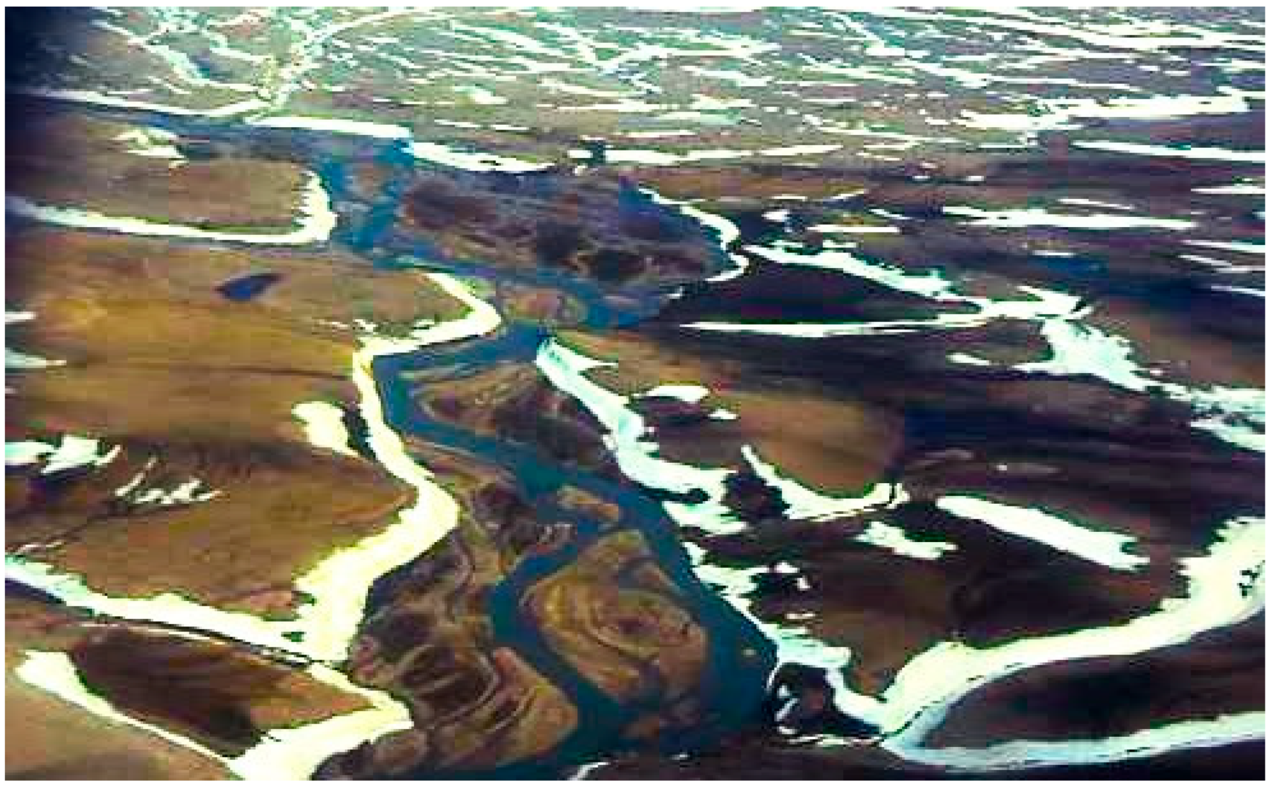
Figure 4.
Branch of the Lena anastomosing system (Siberia) with scrollbar formation (A,B) and mega ripples (B) at the bar surface (north of Yakutsk), finely laminated sands within scroll bar (C) with occasional initial soil formation and cryoturbation during phases of non-deposition (D).
Figure 4.
Branch of the Lena anastomosing system (Siberia) with scrollbar formation (A,B) and mega ripples (B) at the bar surface (north of Yakutsk), finely laminated sands within scroll bar (C) with occasional initial soil formation and cryoturbation during phases of non-deposition (D).


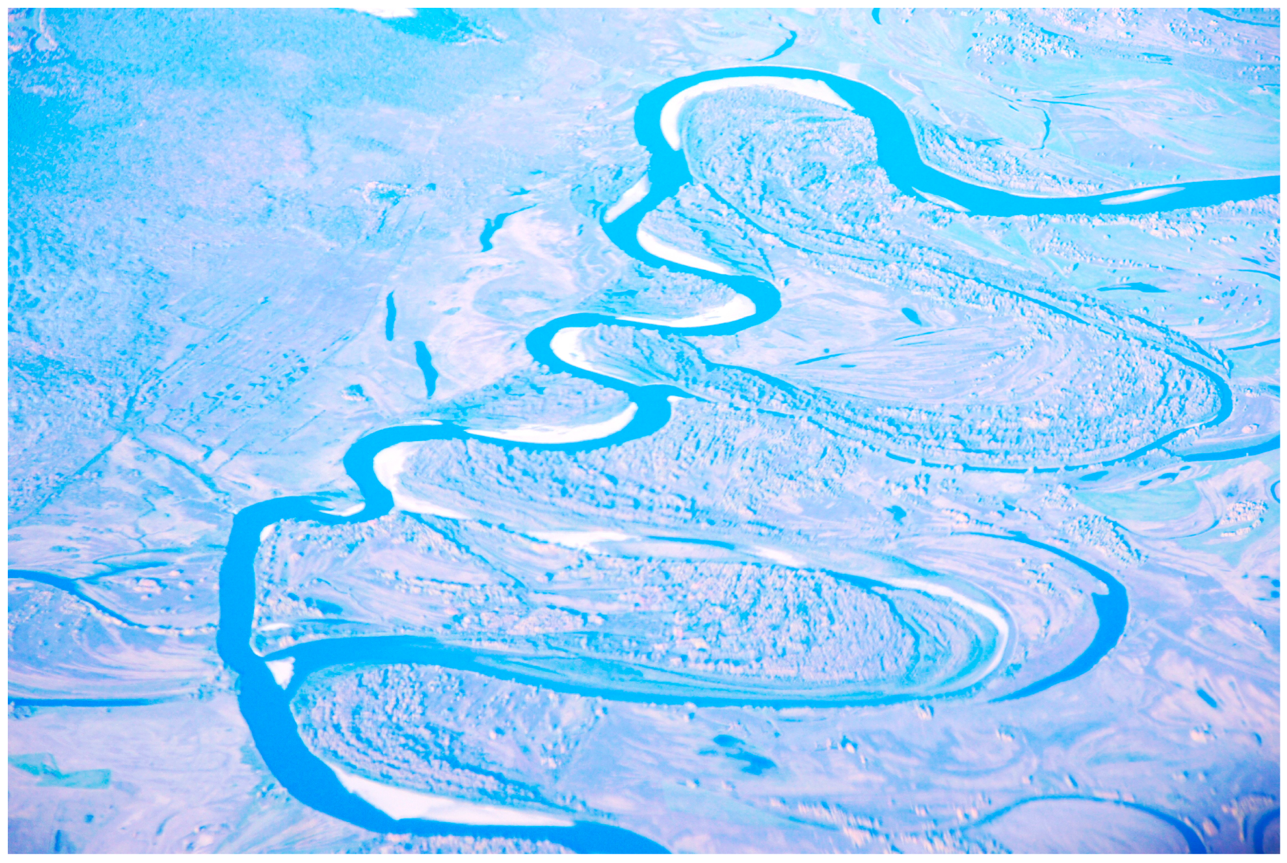
Figure 5.
Very large palaeomeanders (last glacial) of the Ob River, Russia (photo taken from 10 km high) compared with the small-sized Holocene meanders. See also [53].
Figure 5.
Very large palaeomeanders (last glacial) of the Ob River, Russia (photo taken from 10 km high) compared with the small-sized Holocene meanders. See also [53].

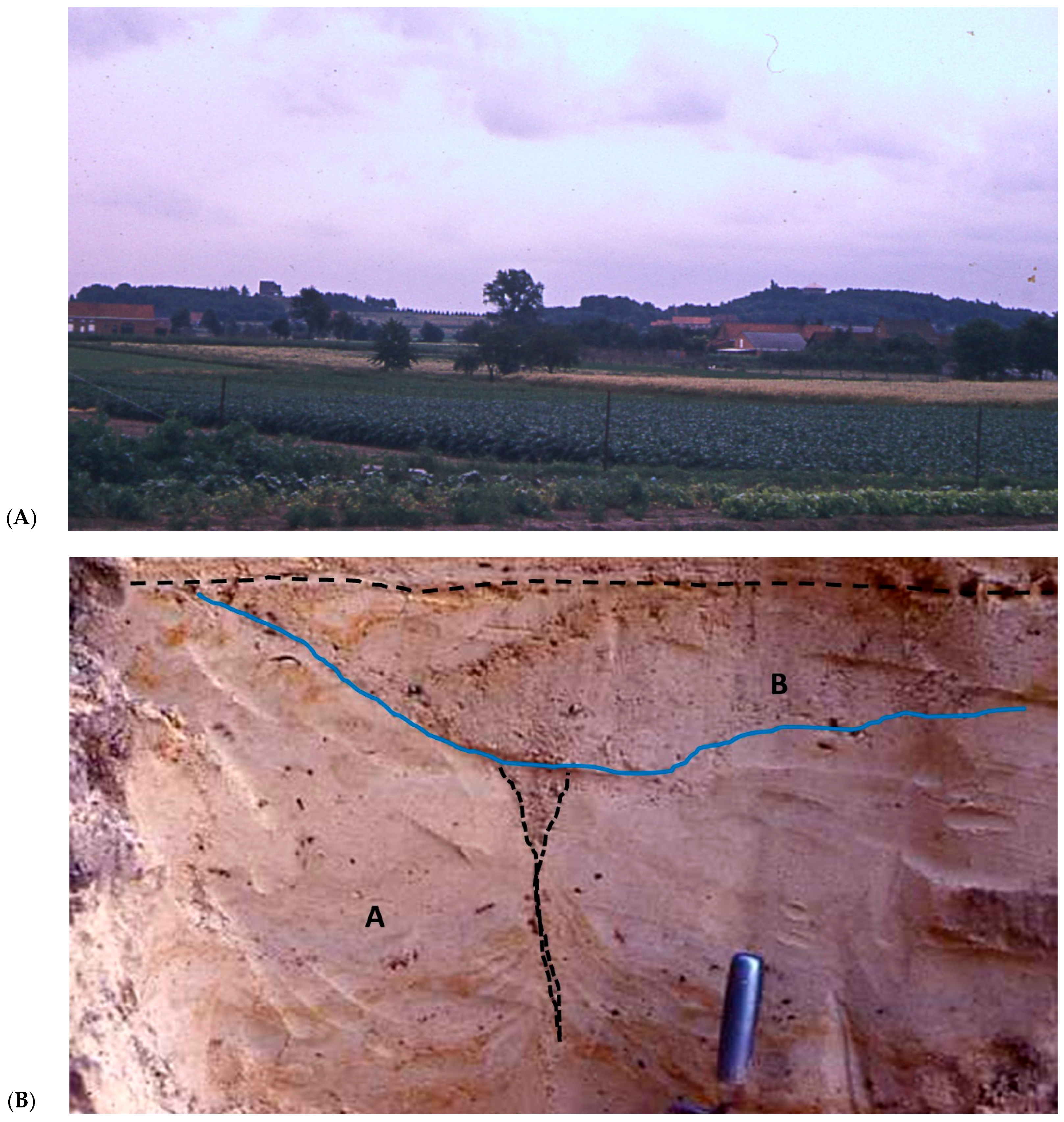
Figure 6.
(A) Cryopediment (at the foreground of the photo) of last-glacial age at Baal (central Belgium) in front of residual hill consisting of resistant clay at the top (in the background); (B) Lutterzand (east Netherlands): lower part consisting of fluvio–eolian sands deposited by shallow runoff (A; OSL-ages 22–27 ka), thus, just before or at the beginning of the last cold maximum, in which a lower remnant of (ice?)-wedge cast is preserved (black stippled line) from the maximum cold around 25–18 ka (Table 2). The wedge cast is truncated (full blue line) by a shallow gully filled with coarse sand (B), and, finally, cut off by a desert pavement (dashed black line; OSL-age c 17 ka). The two fluvial phases (A and B) were formed during cryopediment formation, just before and after the maximum permafrost phase at c. 22–18 ka. More detailed information about dating and stratigraphy in [60,61].


Table 1.
Comparative summary diagram of hydro-morphological development in continuous and discontinuous permafrost conditions.
Table 1.
Comparative summary diagram of hydro-morphological development in continuous and discontinuous permafrost conditions.
| Permafrost Condition | Hydro-Morphological Processes/Forms, Soil, and Vegetation Conditions | ||||
|---|---|---|---|---|---|
| Valleys | Interfluves | ||||
| Precipitation, Drainage | Morphology | Soil, Vegetation Cover | Precipitation/ Drainage | Morphology | |
| discontinuous permafrost | -snow accumulation, occas. summer rain -high discharge after snow thaw -icings, snow dams -base flow | variable drainage pattern: from large meandering to anabranching and braided (according to local conditions) | -rather thick active layer -high soil permeability -vegetation: tundra, taiga | -local snow accummulation -intense surface runoff after snow melt → | Removal of thawed sediment in dense network of rills and gullies -> cryopediment formation |
| continuous permafrost | high-energetic channel flow at snow-breakup, otherwise weak activity | braided at snow-breakup, otherwise trend to more confined channel pattern | -thin active layer -low soil permeability -vegetation: from bare to tundra/taiga dep. local conditions | -thin snow cover -snow drift -weak runoff → | -aeolian deflation -minor sediment removal |
Table 2.
Synthetic scheme of morpho-sedimentary evolution in relation to permafrost conditions during the Weichselian late Pleniglacial in the Belgian–Dutch lowland.
Table 2.
Synthetic scheme of morpho-sedimentary evolution in relation to permafrost conditions during the Weichselian late Pleniglacial in the Belgian–Dutch lowland.
| Chronology | Permafrost Condition | Morpho-Sedimentary Activity | Landforms/Sediments |
|---|---|---|---|
| <16 ka | No/sporadic permafrost  | Aeolian deposition; dry conditions Aeolian deflation | Coversands Desert pavement |
| c. 16-(17)18 ka | Discontinuous permafrost | Intense surface runoff | Shallow rills and gullies → cryopedimentation |
| c. 25-(17)18 ka | Continuous permafrost (LPM) | Channel peak flow at snow breakup; Stable interfluves | Channel deposits (incl. reworked aeolian deposits) |
| Discontinuous permafrost | Intense surface runoff | Shallow rills and gullies → cryopedimentation |
Disclaimer/Publisher’s Note: The statements, opinions and data contained in all publications are solely those of the individual author(s) and contributor(s) and not of MDPI and/or the editor(s). MDPI and/or the editor(s) disclaim responsibility for any injury to people or property resulting from any ideas, methods, instructions or products referred to in the content. |
© 2024 by the author. Licensee MDPI, Basel, Switzerland. This article is an open access article distributed under the terms and conditions of the Creative Commons Attribution (CC BY) license (https://creativecommons.org/licenses/by/4.0/).
Share and Cite
MDPI and ACS Style
Vandenberghe, J. Fluvial Morphology in Different Permafrost Environments—A Review. Quaternary 2024, 7, 15. https://doi.org/10.3390/quat7010015
AMA Style
Vandenberghe J. Fluvial Morphology in Different Permafrost Environments—A Review. Quaternary. 2024; 7(1):15. https://doi.org/10.3390/quat7010015
Chicago/Turabian StyleVandenberghe, Jef. 2024. "Fluvial Morphology in Different Permafrost Environments—A Review" Quaternary 7, no. 1: 15. https://doi.org/10.3390/quat7010015