1. Introduction
Climate change involves distinct biochemical and mechanical processes that occur within and above the oceanic and continental crust [
1,
2,
3,
4,
5,
6]. One of the most noticeable effects of climatic variations and coastal margin modeling in this study is the rise and fall of sea levels during the Quaternary period [
7,
8,
9,
10]. All these effects of changes, which occurred in the past, are recorded in the sediments and in the shaping of the terrain, depending on sedimentary inputs or erosional processes, as well as glacial and interglacial stages, which are defined as Marine Isotope Stage (MIS), as well as intense precipitation or erosion by the sea, river, and wind [
2,
11,
12,
13,
14,
15,
16]. The changes in the terrain are mostly due to the contribution of sediments transported from the continent, such as debris flows and colluvium-alluvium deposits due to heavy rains and chaotic landslides [
17]. The contributions of marine sediments to the continent are by sea level advancement, known as Holocene transgression [
18,
19].
The periods of recurrence of natural hazards associated with climate change have generated multiple geological hazards over time [
20], which have abruptly modified the landscape, including the central coast of Ecuador [
17,
21]. It is thus that the historical and prehistoric episodes that have displaced pre-Columbian coastal cultures, such as the Manteña, Jama-Coaque, Guangala, Chorrera, Machalilla, and Valdivia, have been evidenced on that ground [
22,
23,
24,
25,
26].
2. Study Area and Geology
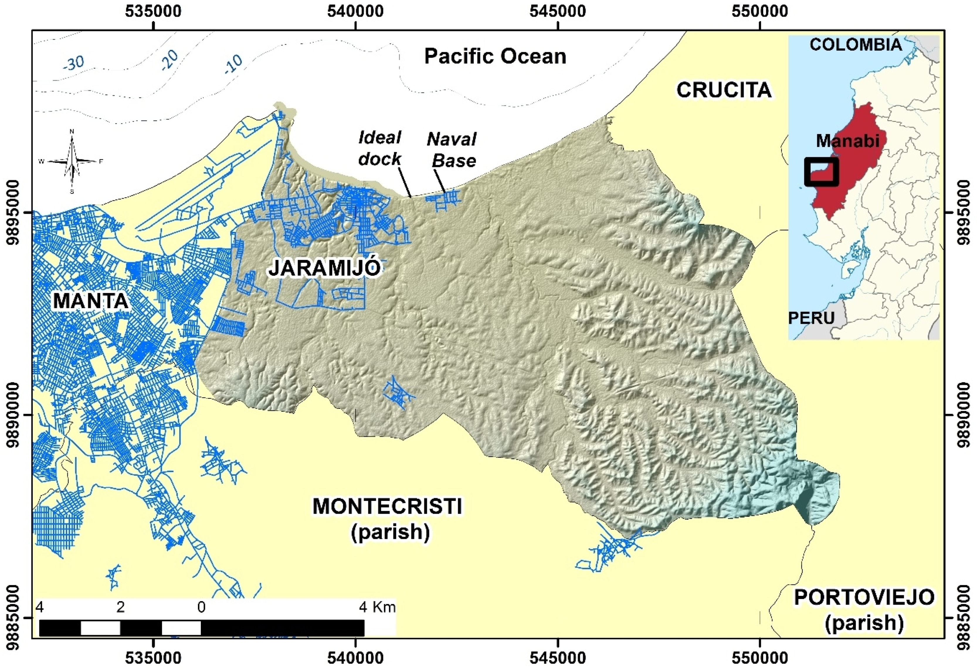
For paleoclimatic and paleogeographic reconstruction, a site that fulfills all the previously described sedimentary characteristics is the coastal strip of the Jaramijó area in the province of Manabí, along the Pacific coast of mainland Ecuador (
Figure 1). Well-preserved quaternary stratigraphic sequences have been analyzed in slope cuts on coastal and hill cliffs, and these reveal new evidence of a coastal depositional environment of the Late Pleistocene to Holocene, as well as of volcanic ash deposited in two directions by secondary triggered lahars and of ashes by fall-out.
The Jaramijó area presents coasts with relatively low hills, having heights between 4 and 20 m above sea level (m.a.s.l.), while, further inland, they display hills with heights between 20 and 45 m.a.s.l. Additionally, this area also has high hills in the boundaries of the Montecristi canton, reaching heights of up to 175 m. In Jaramijó, sedimentary deposition levels associated with a sedimentation of transgression have been found from the foot of the cliff to the high hills that have been later raised by the active tectonics of the region [
27,
28]. The marine terraces on the site have been eroded by climatic factors, such as the excess of high precipitation that occurred at some point on the area of Jaramijó. These are nowadays evident on the land surface and in the river sections (
Figure 2).
In this context, the Jaramijó coast presents rapid change scenarios, which correspond to marine processes (wave dynamics and currents), stratigraphic (highly erodible rocks such as sandstone and siltstone), tectonics (fracture in rocky massifs and structural alignment that are responsible for the uprising or subsidence), and morphological (sea terraces in the process of erosion by river processes), which, when combined with other factors, such as meteorological factors (rainfall, air temperature, wind, and humidity) cause very sudden relief changes.
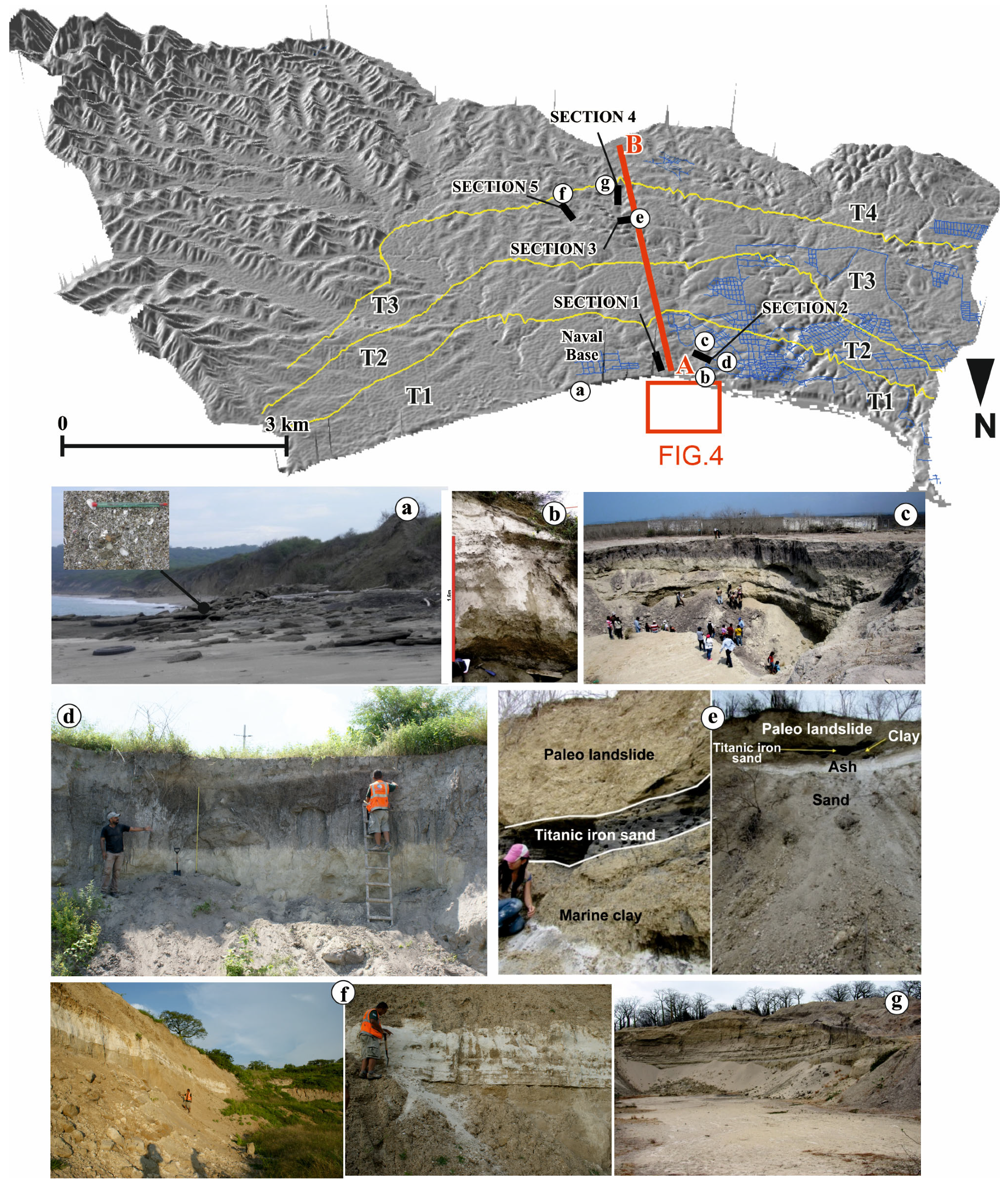
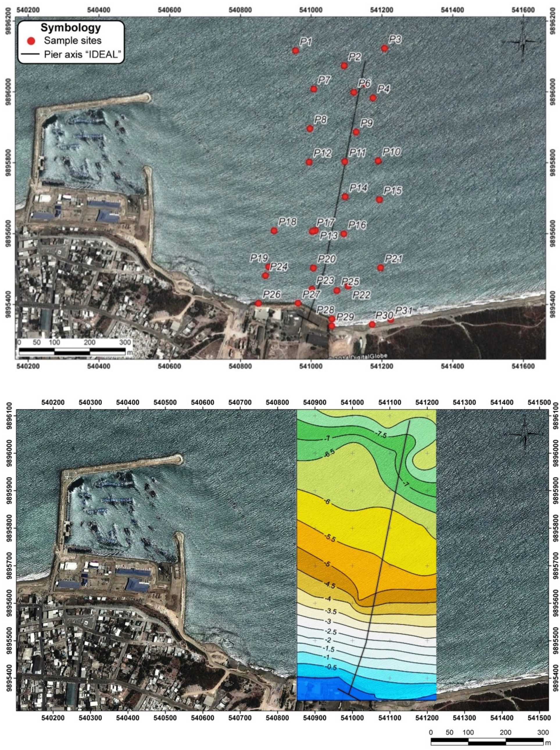
In the current study, we analyzed five sampling sites (
Figure 3), obtaining biological information (microorganisms of foraminifera and molluscs), geological data (type of relief, sediments and Quaternary strata), and geochemistry (
14C dates, stable oxygen isotopes and paleo-temperature measurements of the oceans with analysis of carbons and shell remains), which may allow us to provide details of geomorphological and stratigraphic indicators of the climatic changes developed in the Quaternary, within the central zone of the coast of Ecuador.
Geologically, the Jaramijo coastal area is characterized by the rocky basement of claystones rocks from the Dos Bocas Unit of the Tosagua Formation, above which, in some sectors of the abrasion platforms, crop out very compact discontinuous layers of well cemented coquina, which belong to the Tablazo Formation, with sedimentary deposition on the internal continental platform, and whose outcrops in the territory reach thickness of up to 10 m [
29,
30,
31,
32]. Coquina is an organogenic sedimentary rock of Plio-Quaternary age composed mainly of the remains of molluscs that are well cemented in a calcite matrix. They outcrop as marine terraces raised by active tectonics on the continental coast of Ecuador, especially the provinces of Santa Elena and Manabí. Pleistocene marine clays with thicknesses up to 5 m cover the coquinas and claystones. Subsequently, they lie above recent sediments that have well conserved sedimentary and volcanic Late Pleistocene to Holocene sequences along the coastal cliffs and in some open quarries within the canton. These sediments are formed by beach sands with ferrous oxidation and abundant molluscs (
Figure 3), covered by volcanic ashes of secondary lahars and by fall-out deposition that reach thicknesses of up to 0.6 m in some lithologic units [
17], which themselves lie above uncemented grayish sands, which form the lithology of many beach ridges in the area of Jaramijó.
The entire stratigraphic sequence and, in particular, the Holocene, indicate a type of emergent coast with progradational sedimentation, which means that this coastal strip is rising a few fractions of a millimeter every year [i.e., 0.5 mm/year] [
27] or by sudden tectonic lifting (~0.2–0.3 m), such as that which has recently been documented in the Pedernales 2016 earthquake, [
32,
33]. The terminologies of transgression and progradation depend on the advance or withdrawal of the sea level. When the level of sea is withdrawn, this is called “regression”, and, from the continent, the rate of progradational sedimentation increases. However, when the sea level advances towards the continent, there are contributions of marine sediments by transgression [
34].
The geomorphological landscape tends to be combined with active tectonics due to the high recurrence of tectonic uplift where strong earthquakes with 7.5 ≤ Mw ≤ 7.9 occur every 70 to 80 years, since it is usual to observe the Quaternary marine terraces and their strata, formed of marine molluscs, raised with slopes of altitudes in the form of a ladder [
27]. During the Holocene time during a postglacial period, the climatic conditions varied little compared to the other interglacial stages recorded in the past [
35]. Therefore, these climatic cycles may have left strong traces in the landscape, as evidenced in the Jaramijó area, when there are very marked river incisions and rapid erosion in the relief.
During data compilation in the field, we also evidenced multiple landslides along the coastal strip. The dynamics of the sea waves eroded the coastal cliff that indicated a height between 10 and 18 m, which gradually collapsed the base of the slope, and, in this way, the ocean–continent contact line receded from its position. At the Jaramijó Naval Base (BASJAR;
Figure 2), there has been evidence of a quay being destroyed, and its concrete walls were torn from its foundations due to up-to-date marine dynamic erosion. The cliffs that are evident on the coast are in the process of rapid marine erosion, forming the rocky platforms of abrasion that have been left by the retreat of the same. Therefore, the hills were eroded and transformed into rocky plains [
36]. These cliffs are of low-to-medium height, and they are associated with sandy beaches with slopes of 5° to 15°. In addition, in this coastal strip (except for the craft pier), there are no engineering works and constructions of breakwaters to counteract the effects of erosion dynamics by sea waves.
3. Data and Methods
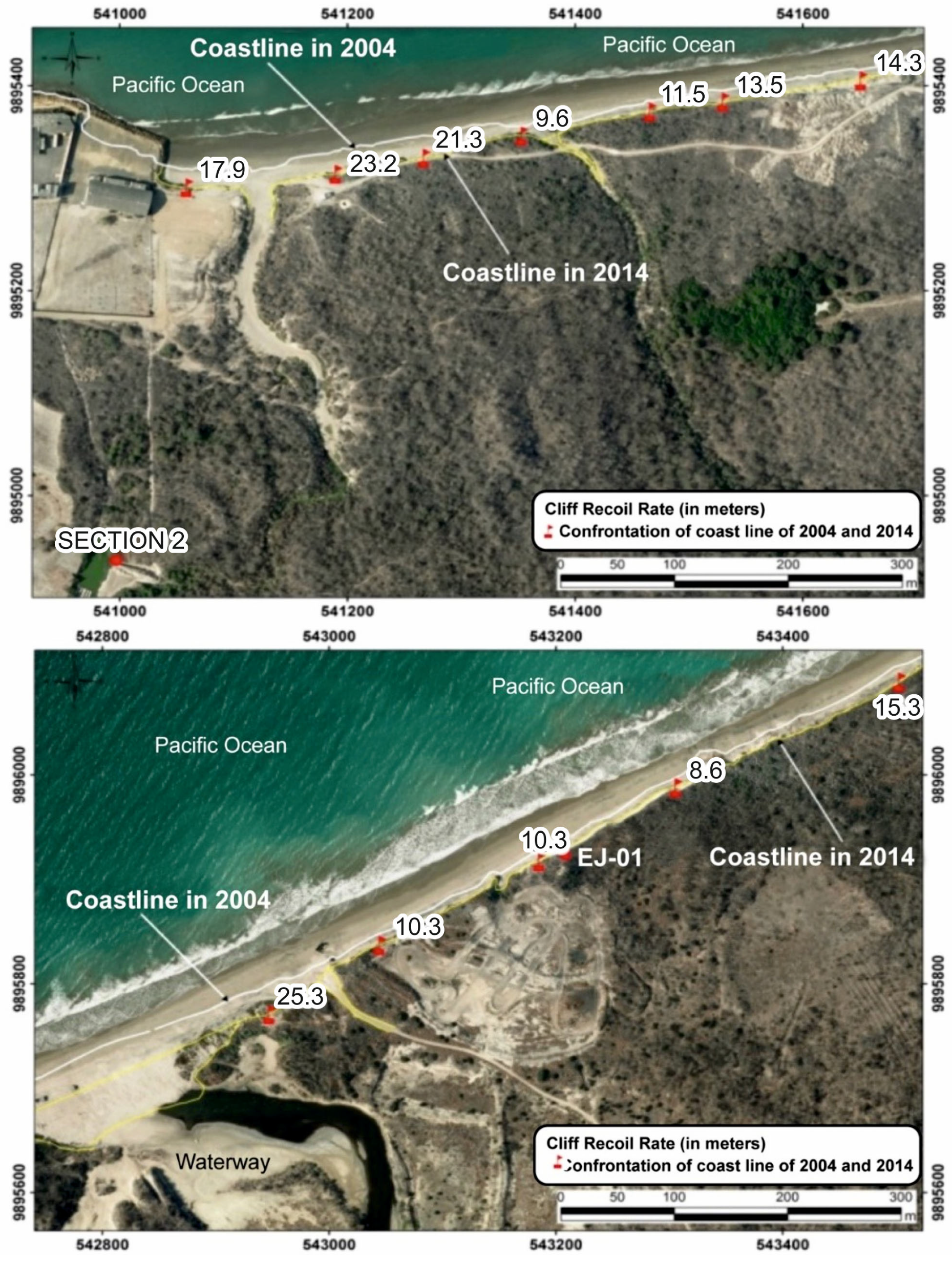
The research methodology of this study comprises two phases, the first being the geological analysis and coastal vulnerability, and the second being the paleogeographic, as well as the climatic interpretation, of the Quaternary period. In the first phase, aerial photos from 1965 were analyzed with images provided by Google Earth of the year 2016, as well as topographic data generated by the Ecuadorian National Oceanographic Institute of the Navy from 2004 and 2014 (
Figure 4), allowed to obtain data with an accurate altimetry in the field [
21,
37].
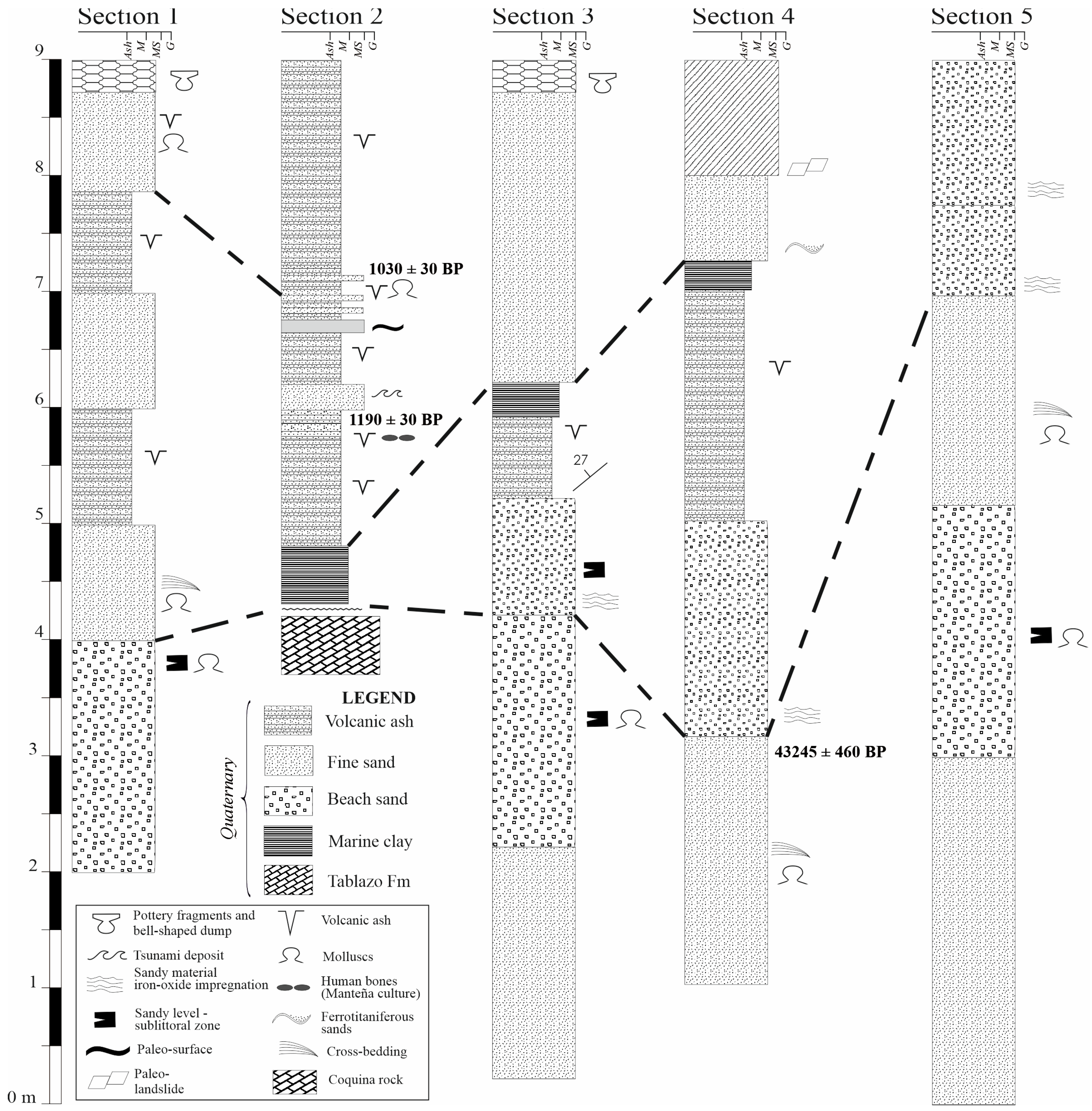
In this first stage, the geomorphological and stratigraphic information of sedimentary sequences is compiled from five sampling stations in outcrops of geological cuts and thirty-one (31) samples of beach sediments. In addition, the types of lithological units are detailed, and they are realized within five stratigraphic columns (see
Figure 2). Mollusc remains were selected from the lithological units to determine the relative age by
14C analysis and paleo-temperature through stable oxygen isotopes, using “Beta Analytic”. The collection of lithological and geomorphological data allowed us to corroborate, in the second phase, the analysis of types of terraces raised by the active tectonics of the site, which have been modifying the landscape of the study site for 43,245 years. This age is determined for a paleo-cliff identified in this study at a distance of 4 km from the current coastline [
17,
21,
28].
In the field, we applied a vessel of a sediment sampling instrument, “van veen”, for the extraction in the marine floor, reaching the counter of −10 m below sea level [
38]. The depth of the water column has been determined with the weight and rope technique. Hereby, in order to obtain 31 samples of sediments on the Jaramijó shoreface and foreshore zones, we used a GPS Magellan brand with high precision (
Figure 5). The GPS allowed us to locate the coordinates UTM WGS 1984, datum 17 S, along the internal coastal platform. The position of coordinates and sampling have an approximate meshing between 50 and 100 m. With the depth isobath data of the water column obtained in the field phase, and applying the kriging technique of the Surfer 16 and GIS ArcGIS TM 10.5 software, we have interpolated depth values for the generation of a bathymetric map (
Figure 6). This analysis allowed us to estimate the high rate of erosion of coastal cliffs associated with the transgression of the Holocene.
Afterwards, stratigraphic columns were performed in sections of slopes of hills and sea cliffs, selecting five sites with well-preserved volcanic and sedimentary structures and levels. Then, sandy sediment analyzed in the stratigraphic units have been conducted in order to find micro (i.e., foraminifera, radiolarians) or calcareous macro-organisms (bivalves and gastropods), which allow for the indication of the sedimentary deposition environment and other associated characteristics to sedimentary structures of high energy (influence of waves), moderate energy (subtidal estuary environment), or low energy.
For the selection of microorganisms, we applied the finest mesh sieve, being a technique applied to collect planktonic and benthic foraminifera from the marine to transitional environment [
21,
28]. These techniques allowed us to understand the type of sedimentary environment of the lithological unit and its position on the continental margin of the internal platform, external platform (neritic environment, sub-coastal zone), and continental slope (oceanic environment, bathyal and abyssal zone).
In the second phase, ground reconnaissance, stratigraphic analysis, and radiometric dating techniques applied to Quaternary sedimentary sequences located on the Jaramijo area allowed us to recognize the upper Pleistocene- to Holocene-uplifted terraces. For a better understanding of the paleo-geographic evolution, a topographic profile has been elaborated, indicating three marine terraces and their relation with tectonic uplift, including additional information provided by Pedoja [
27]. The terraces differ much in their stratigraphic correlations and geomorphological features. In order to delineate the paleo-coast with an estimated age of about 43,245 ± 460 years B.P., the use of orthophotos and digital model of the terrain in GIS platform has been used. This methodology and research phase provided fundamental information on the sedimentary contributions in the Jaramijo area, as well as its glacial, interglacial stages, and interstadial phase episodes during sedimentary deposition on terrace T3, as well as its relationship with the tectonic survey of the central coast of Manabi.
4. Results and Discussion
4.1. Lithology of Recent Wave-Cut Terrace
The topographic analysis, including altimetric data and study of aerial photos, allowed us to establish the fast rate of the retreat of this coastal cliff margin, being 11 to 24 m every ten years or 1.1 to 2.4 m per year, which indicates the fast rate of erosion of the cliff formed lithologically by claystone rocks, as well as of soft sediments and of easy rippability (
Figure 6).
Lithologically, this sequence is composed of a layer of gray, massive uncemented ash that may reach two meters thickness at the top of the cliff. Its origin is associated with chaotic deposition by lahars, which contain remains of pre-Columbian pottery belonging to the Manteña culture (
Figure 3). Below this layer occurs sand with a medium grain size with the presence of marine molluscs, with grayish ash levels. Some sands contain mixed ash inside, indicating a high energy deposition. At this level, the paleo-soil layer is of age
14C of 1030 ± 30 B.P. Subsequently, it is followed by a layer of massive gray ash, where its base contains reworked material, and a layer of fine to medium-grained sand, which covers the sandy coseismic layer.
Then, the layer presents an upper and lower erosive contacts and chaotic deposition of medium to fine-grained sand, characterized by marine microorganisms and echinoderm spicules that identify the marine sedimentary contribution, besides the addition of benthic and planktonic foraminifera. The identified foraminifera were Globigerina sp., Girodinides sp. (sedimentary environment of internal platform), Melonis sphaeroides, and Melonis barleeanum (lower bathyal sedimentary environment), that is, a mixture of foraminifera with dominances of different habitats. Subsequent stratigraphic analysis allowed us to identify that this layer corresponded to an anomalous sedimentary deposit, which is probably associated with a bottom sediment drag by refraction of a tsunami wave with potential 6.3 m.a.s.l. run-up height with an estimated age of around 1200 ± 30 B.P.
Further below, this sedimentary sequence is one of the most important in the site that provides natural hazard information and affectation of pre-Columbian cultures. Some of the most remarkable geoarchaeological findings in this outcrop were human bones related to the Manteña culture integration period, within a 8 to 25 cm-thick volcanic ash layer [
39] (radiocarbon dating of 1.190 ± 30 B.P.). In the lower part, a layer of massive, uncemented gray ash is followed by a unit of slightly hard marine clay. At the top appear traces of whitish roots, possibly of calcium sulfate, which are associated with paleosol. This entire Late Pleistocene—Holocene soil sequence is deposited on a rocky massif, which consists of hard coquina from the Tablazo geological formation. Further below, there are brown shales of the Dos Bocas Member of the Tosagua formation.
All of these stratigraphic and paleoseismologic features will allow us to understand the catastrophic series of geological events that abruptly shaped the landscape, such as subduction earthquakes, local tsunamis, and volcanic lahar–ash landslides. Above this sequence appear extensive alluvium-colluvium deposits, secondary debris flows, and distal rain triggered lahars from the mid and upper hills of the southern and southeastern part of the Jaramijó area (
Figure 2).
It is fundamental to indicate that, in the analysis of the sediments, fossils of Eocene and Miocene radiolarians were found, which were separated from the sediment units attributed to the Quaternary [
31]. One of the characteristics to differentiate them has been the tonality and the wear of the chambers of their shells.
4.2. Shorezone Sediment Distribution Map
In the shore zone, the work at sea compiles 25 samples of silt, sandy silt, silty sand, and moderately sorted medium sand bottom sediments with abundant molluscs, as well as six samples of beach sand on the mainland. These data allow the generation of a bottom sediment distribution map (
Figure 6) and a detailed bathymetry map (
Figure 5). During the sediment extraction phase, using the “van veen” instrument, no samples have been obtained in rocky areas, while little coarse-grained sandy material indicates that it is coquina-type rock (belonging to the geological formation Tablazo) found in high sea floor bathymetry (see
Figure 6, bottom sediment distribution map). It follows that these rocky strata are covered by a thin layer of sandy sediments.
According to the macroscopic analyses of the granulometry performed on the obtained samples in the sea floor and to the corresponding position of the UTM geographical coordinates, a sediment distribution map has been generated. There, a sedimentological change has been evidenced while entering the sea floor, and, as in the coastline, there was a predominance of fine- to medium-sized sand, which is representative along the beach strip (
Figure 6). In the depth isobaths (
Figure 5) between −1.5 m to −3.5 m, the sediment is of silty sand, and it reduces its granulometry to sandy silt in the bathymetric contour of −3.5 m to −5.5 m. At a distance of −5.5 m to −5.8 m, a narrow strip of silty sand indicates an increase in sediment grain, while, from−5.8 m to −6.2 m, there is a predominance of fine sand. Between the contours of −6.2 m to −7 m, there are variations of fine sediments between silty sand and sandy silt. From −7 m to −8.2 m, there is a predominance of sediment silty sand. The medium- to heavy-grain sediments are to the northwest of the site, and an isolated sector is located to the northeast, between the contours −7.5 m to −8 m. High rocky parts in the shallow water column (contours −1 m to 1.5 m) have been encountered to the southwest near the coastline and to the craft pier of Jaramijó (marked as rock in the map;
Figure 6).
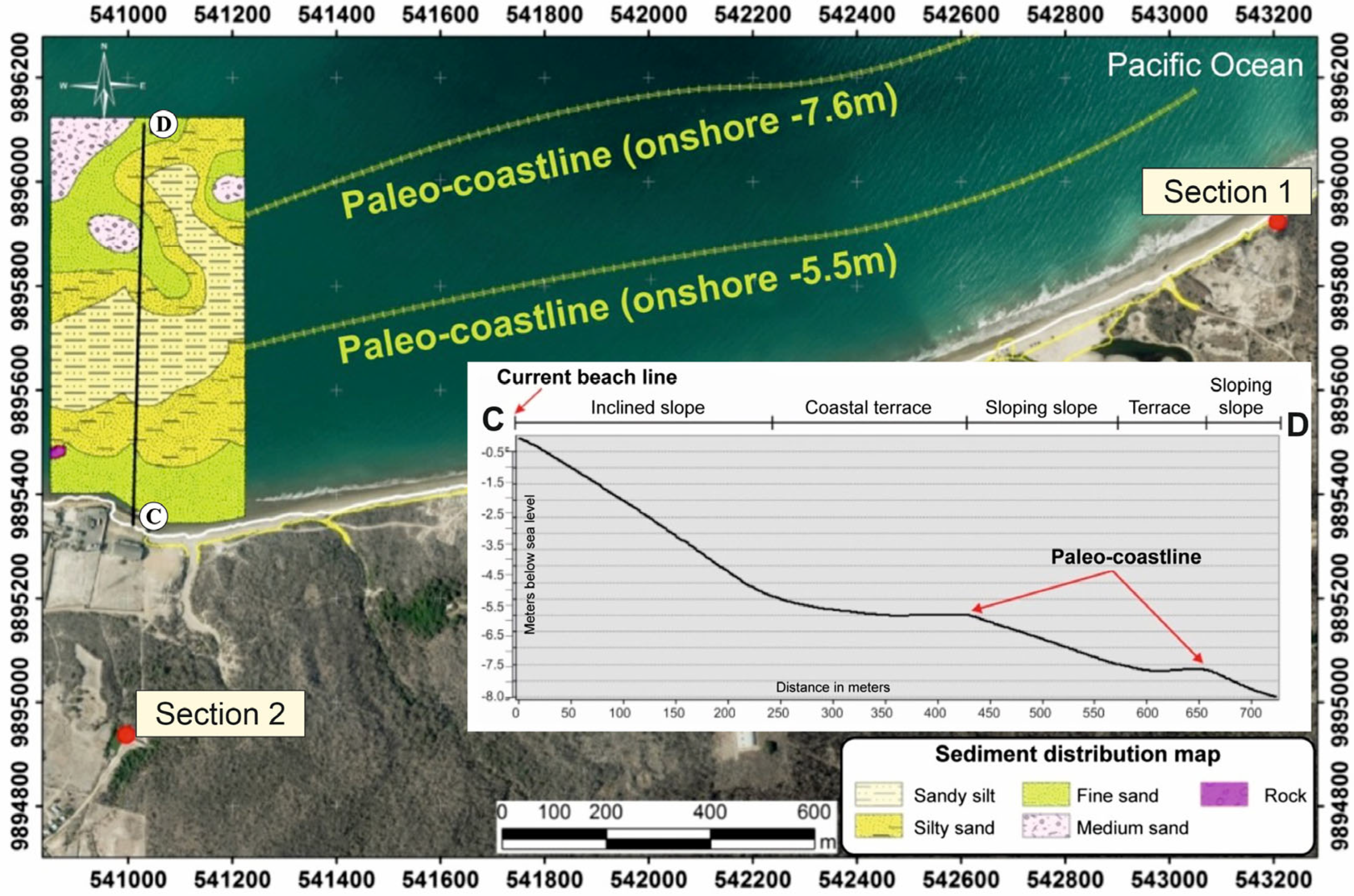
The bathymetric profile A–B (
Figure 6) indicates, from the present beach line to the contours of −5 m, that there is a narrow strip, which has been geomorphologically attributed to a zone of a steep slope with an inclination of 16° to 35°. From –5 m to the −6.5 m, there is a coastal slope with a gentle inclination between 2° to 4°, which is possibly attributed to an old coastline or paleo-coast (
Figure 6). From −6.5 m to −7 m, the steep inclined slope to a moderately steep slope reaches inclinations between 8° to 16°. In the contour of −7 m, a new narrow coastal terrace sloping slope between 4° to 8° develops, which also forms and represents a paleo-coast. From −7 m to −8.2 m, a moderately steep slope between 8° and 16° is again evident (
Figure 6).
Interpreting this bathymetric profile, we are able to indicate that: (a) the three coastal terraces are associated with paleo-coastlines, and the inclined slope represents an accelerated increase in sea level rise, and the distance between one and the other is a consequence of the variations recorded by the Holocene transgression in the MIS-1 (
Figure 7). However, something significant has been evidenced in the upper slope due to the rapid increase in sea level near the present coastline being the last advance of Holocene transgression (
Figure 7). In this context, the coastal strip has sedimentary contributions by the marine transgressions of the interglacial period and significant progradational contributions during the proglacial periods.
4.3. Paleogeographic Reconstruction of Jaramijo Area
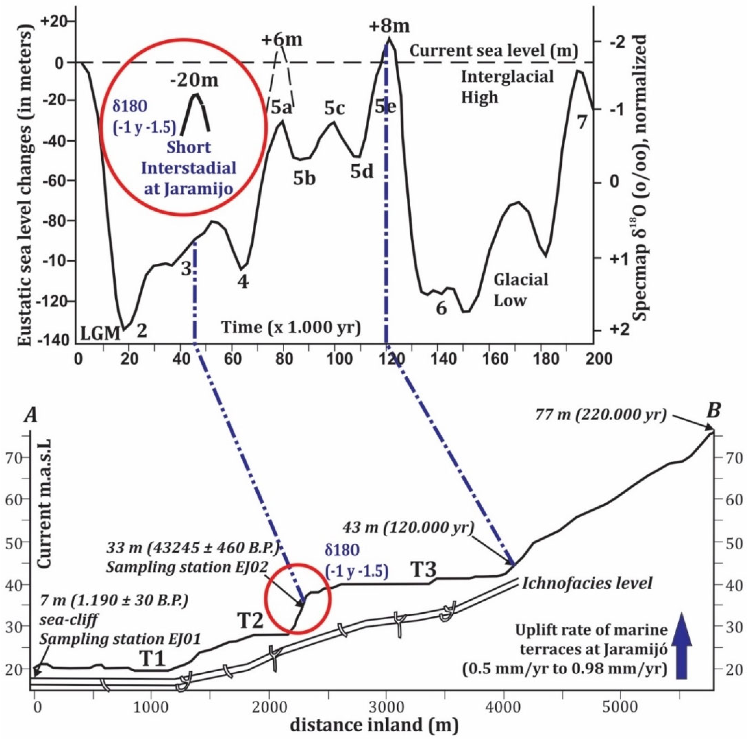
For the interpretation phase, and for a better understanding of the paleo-geographic evolution, a topographic profile has been elaborated, indicating three marine terraces and their relation with tectonic uplift, including additional information provided by Pedoja [
27]. The terraces differ much in their stratigraphic correlations and geomorphological features. In order to delineate the paleo-coast with an estimated age of about 43,245 ± 460 years B.P., the use of orthophotos and digital model of the terrain in GIS platform has been used.
The marine terraces, from the bottom to the top, are: T1, next to the coastline at an altitude of 20 m a.s.l. (above sea level) (dated 1190 ± 30 BP to 1030 ± 30 years BP), the T2 terrace at 30 m a.s.l. (43,245 ± 460 years B.P.), and T3 at an altitude between 40 m a.s.l. The T4 terrace was previously recognized by Pedoja [
27], but our research outlined three new terraces (here named T1 to T3), which are mostly covered by distal rain-triggered lahar deposits.
Therefore, the paleogeographic reconstruction of T1, T2, and T3 are linked with the continental margin active tectonic object, which is referred to from MIS 3 (range of ages: 59,000 to 24,000 BP) to MIS 1 (range: 18,000 years ago to the present) [
14]. We identified and delineated, in the T3 terrace, a paleo sea-cliff where the coastline of that time was 4 km away from the current coast, raised up to an altitude 20 to 25 m above sea level. We refer to the age of the paleo-cliff with
14C of Cal. BC 41,295 to 40,140 years (Cal. BP 43,245 to 42,090 years), belonging to the third Marine Isotope Stage (MIS-3). Although MIS-3 is associated with a less intense glacial period, our currently obtained data are interpreted to indicate that the central coast of Ecuador had a short interstadial phase, demonstrating warm years in a glacial stage. In this study, δ18O referred to the lithological unit of this paleo sea-cliff, and it indicates values of −1 and −1.5. Both values correspond to two types of sediment samples located at different distances but belonging to the same sedimentary level. MIS-3 was less warm than the present MIS-1 and the last normal recorded terrace, MIS-5.
Terrace T3 is defined by six well differentiated layers from the base to the top of the Quaternary sequences. At various quarry sites and slope cuts, an erosional and discordant contact delimits an older layer. There, a sandy level with abundant remains of molluscs has been evidenced on the three raised sea terraces, and this may represent the sublittoral zone likely to occur during the MIS 5a interglaciation period, when the sea level reached +6 m above the current sea level some ~70,000 years ago [
14] (
Figure 7).
Above, it appears that an uncemented middle sand layer with abundant mollusc fragments was identified, and these fragments were identified as trachycardium (Mexicardia) pro, Divalinga perparvula, Diplodonta obliqua, Lucinisca centrigufa, Diplodonta sericata, Lirophora mariae, Donax dentifer, and Donaxobesulus. Hereby, these species provide information on the sedimentary deposition of this unit, being from marine and intertidal zones of the continental shelf, indicating that the sedimentary level during its sedimentation phase was in a water column between 0 to −30 m. In the Divalinga perparvula species, the most predominant in the sedimentary layer, a dating was performed, obtaining a dated age of this unit, which is 43,245 ± 460 years B.P., and paleo-temperature data from −1 to −1.5 δ18O were proposed. Above, it follows a fine-grained sand unit, with angular to subangular quartz particles, as well as the presence of lignites, resins, few mollusc fragments, and echinoderm spicules. The coloration of this level may indicate possible oxidation, as it is found during its deposition in an aerobic environment.
It follows that a homogeneous whitish ash layer has been deposited by “fall-out” or lahar, probably from the Cuicocha, Quilotoa or Pululahua volcano, having lapilli ash rich in pumices, crystals, and lithic deposits [
17,
33,
41,
42]. Above this entire sequence, there appears a 1–3 m thick layer of brown to yellow marine clay, gypsum inclusions, and sporadic ash lenses, interspersed at the base with layers of whitish volcanic ash, abundant gypsum, and sandy clay. Overlying these is a layer of ferro-titaniferous black sands (40%), which are interspersed with continuous laminations of fine brown sand and cross-laminations, which are associated with a high energy deposit, representing a Paleo-cliff. There are no remains of marine molluscs. However, the stratigraphic characteristics indicate that its sedimentary environment corresponds to an intertidal zone. The upper layer is the most recent chaotic deposit of the place, which is characterized as a paleo-landslide or alluvial deposit, possibly occurring at the end of the upper Pleistocene (Tarantian floor). The clasts are heterogeneous (of different lithology or type of rocks), and they possess angular edges, which represent a short transport from the source uprooted from the high hill and deposited in the river valley of the site.
5. Conclusions
The study area represents a coastal margin that has a well preserved sedimentary and volcanic sequence of geological deposits from the upper Pleistocene to Holocene, outcropping on the coastal cliffs, and cut slopes in hills. From a geomorphological analysis point of view, the Jaramijó area presents an emerging-type coastline.
In this study, the estimated tectonic uplift rate for the terraces T1 to T3 (MIS-3 to MIS-1), based on altimetry data confronting the ages of the sedimentary levels and paleo-cliffs, was 0.5 to 0.98 mm per year. Pedoja [
27] estimated a rate of 0.31 to 0.39 mm per year, considering that the oldest marine terraces are between 120,000 years (MIS 5e), 220,000 years (MIS 7), and 330,000 years (MIS 9) old.
The reconstruction of the paleogeographic evolution of the site evidences depositions or sedimentary contributions, which were presented during MIS 3 to MIS 1. The Jaramijó study site has a high paleoclimatic record. The data of the current study allowed us to reconstruct the paleo-geographic and paleo-climatic evolution of the Jaramijó site, indicating that the quaternary and volcanic sediments present an interglacial period and two glacial periods, and the short interstitial stage recorded 43,245 years ± 460 BP. Due to the mapping and analysis and two further, but younger, paleo-coastal cliffs, we were able to reconstruct that the Late Pleistocene to Holocene transgression modified the central coast of Ecuador and increased the level of coastal climate hazard by a subsequent sea-level rise.
Referring to MIS-1 and the holocenic transgression, paleo-coastlines have been evidenced to have depth contours of −5.5 m and −7.6 m, at 440 and 650 m distances from the current coastline. In the study area, the rate of cliff erosion and wave-cut platforms is in the order of 1.1 to 2.4 m/yr (11 to 24 m every 10 years).
In the anthropogenic soil levels, pre-Columbian excavations with a bell-shaped dump or a bell-shaped waste container of the Manteña culture have been found. During the settlements at the Jaramijo site, some ash layers from lahars and fall-out are evident, including whitish ash with biotite, which may correspond to the eruption and material transported by fall-out from the Quilotoa volcano some 800 years ago. Below this level of ash, an erosive contact delimits the fine sands with broken fragments of pre-Columbian ceramics, broken molluscs, and angular clasts within a chaotic sedimentary level, which most likely is associated with a tsunami event at around 1200 ± 30 B.P. This recent evidence, found in the T1 terrace stratigraphies, indicates that, between 800 to 1200 years ago, the pre-Columbian human settlements suffered significant displacements, as well as the last severe modeling in their landscape of the central area of Manabí, coastal Ecuador.


 ,
, 


