
Disentangling Holocene Climate Change and Human Impact from Palaeoenvironmental Records from the Scottish West Coast

1
Department of Environment and Geography, University of York, Heslington, York YO10 5NG, UK
2
Pre-construct Archaeology Ltd., Endwell Road, Brockley, London SE4 2PD, UK
3
Department of Archaeology, University of Sheffield, Minalloy House, 10-16 Regent Street, Sheffield City Centre, Sheffield S1 3NJ, UK
*
Author to whom correspondence should be addressed.
Quaternary 2023, 6(1), 2; https://doi.org/10.3390/quat6010002
Submission received: 10 August 2022
/
Revised: 6 December 2022
/
Accepted: 8 December 2022
/
Published: 3 January 2023
(This article belongs to the Special Issue Climate Change and Vegetation Evolution during the Holocene)
Abstract
:Phases of rapid climate change throughout the early to mid Holocene coincide with regional human population expansion in Scotland and North-West Europe. Palaeoenvironmental signals of climate and anthropogenically driven vegetation changes can therefore be difficult to separate. To identify whether it is possible to distinguish potential signatures of anthropogenic clearance and agricultural activities from climatic drivers of landscape change in the early to mid Holocene in the region, two topographically contrasting sites on the Isle of Skye and the Isle of Bute were investigated. A multiproxy approach including pollen, spore, microcharcoal, loss on ignition and particle size analyses was adopted to investigate changes in vegetation and climate. There are subtle indications that the 8200 cal BP climate event had an effect on the vegetation composition at both sites. Signals of anthropogenic woodland clearance are apparent early in the sequence at Peat Hill (Bute), indicated by a peak in Poaceae (grass) cereal-type (7–14%) at 8592–8793 cal BP, alongside a decrease in arboreal pollen, which could not be associated with a regional episode of climate change. Early to mid Holocene vegetation changes at Lyndale House (Skye) occur alongside regional changes in precipitation and sea level and therefore cannot be readily separated. Continuous declines in arboreal pollen from ca. 5000 cal BP at Lyndale House indicates the onset of widespread clearance on Skye via felling and sustained grazing pressures.
1. Introduction
The early to mid Holocene climate of northwest Europe was generally warmer and drier than that of the present day [1]. However, palaeoclimatic studies of the period also reveal a picture of instability, with episodes of both rapid and gradual climatic changes which are often associated with alterations in the strength of Atlantic meridional overturning circulation [2]. Ice core data from Greenland signify a major climate change event at ca. 8200 cal BP (calibrated years before present) when annual mean temperatures were approximately 1 °C lower than the recent past, precipitation and methane emissions decreased and conditions were windier [3]. Earlier cooling events of shorter duration are also evident at ca. 9300 cal BP and ca. 11,300 cal BP (the Pre-Boreal Oscillation) [4,5]. Palynological records indicate concurrent vegetation changes in Europe and the British Isles which suggest that the climate events caused woodland recession in many areas, although difficulty lies in distinguishing palynological signals of climate and anthropogenically driven vegetation changes [6]. This is suggested in western Scotland, where there is widespread palaeoenvironmental evidence of landscape change in the early Holocene, alongside archaeological evidence of the presence of Mesolithic populations [7].
This paper presents two new pollen, spore and microcharcoal profiles, supported by radiocarbon dating, for (i) a low-lying coastal site on the Isle of Skye; and (ii), an inland highland site on the Isle of Bute (Figure 1), with the aim of identifying whether it is possible to distinguish potential signatures of anthropogenic clearance and agricultural activities from climatic drivers of landscape change in the early to mid Holocene in western Scotland. The study of two geographically contrasting sites within the same region allows for the potential influence of differing altitudes, aspect and exposure to marine processes on pollen representivity, vegetation mosaics and landscape change to be considered.
2. Materials and Methods
2.1. Site Descriptions
2.1.1. Lyndale House (Isle of Skye)
The Isle of Skye (Figure 1) is the largest and most northerly island of the Inner Hebrides. It is offered a degree of protection from direct exposure to the Atlantic Ocean by the Outer Hebrides to the north-west. It has been the focus of intensive palaeoecological investigations and vegetation reconstructions since the late 1960s, e.g., [8,9,10,11,12,13]. The island provides a unique transitional zone between the mainland and more exposed oceanic islands for Lateglacial and Holocene vegetation. Pollen records generally show a Lateglacial-early Holocene succession from grass and sedge dominated assemblages to birch and hazel woodland [11,12,13]. Inter-site variation exists relating to site exposure and lithology, including the continuous presence of grass-sedge dominated assemblages in exposed coastal sites [12]. In many areas, birch-hazel woodland continued to expand throughout the mid-Holocene, with lesser amounts of oak, elm and pine pollen [13]. From ca. 5000 BP potential anthropogenic indicator taxa associated with disturbance and pastoral agriculture begin to expand in the pollen record and the onset of woodland clearance is evident in records across the island from this date [10,12,14].
The study site at Lyndale House (NG37165499) (Figure 1) is situated at Camas Mór between the Waternish and Trotternish Peninsulas at 5.25 mOD, where a Sphagnum moss surface peat has formed behind a coastal barrier composed of coarse sand and pebbles. Annual mean air temperature in the area reaches a maximum of 11.4 °C and a minimum of 5.4 °C, with an average of 1806 mm of rainfall per annum and regional average wind speeds of 11.23 knots per annum [15]. The study site was initially investigated by Selby and Smith to reconstruct Holocene relative sea-level (RSL) change [16]. The study found that barrier formation was likely to have occurred around 6498–6716 BP. The influence of the Main Postglacial Transgression on the site was recorded as commencing after 8205–8386 (7497 ± 32) BP. Marine regression began to occur after 7280–7426 (6436 ± 37) BP. A summary pollen diagram was presented to provide a broad environmental context for the sedimentary sequences and to corroborate the radiocarbon dates. A higher resolution pollen analysis for the site is now presented in this study.
2.1.2. Peat Hill (Isle of Bute)
The Isle of Bute (Figure 1), in the Firth of Clyde, is protected from the Atlantic weather system by the coast of Kintyre and the Isle of Arran to the west. In comparison to the Isle of Skye, Bute has received minor attention in respect of palaeoecological and palaeoenvironmental research. There are only two published pollen profiles from highland sites, i.e., an archaeological study of Neolithic and Bronze Age funerary monuments at Hilton on the east side of the Ardmaleish Peninsula; and an 11,000 year vegetation record from Red Loch, a former (now infilled) lake site in the North of the island [17,18]. Similar to the pollen records for the Isle of Skye and southwest Scotland, the early Holocene vegetation composition of Bute consists of birch-hazel woodland with lesser amounts of pine, willow and juniper [18].
The study site at Peat Hill (NS09951185) (Figure 1) is an inland peat bog situated on the edge of a col at 75 mOD. It is centrally positioned on the southern peninsula of the isle within Branzet Moss, and to the immediate north of Glen Callum. Annual mean air temperatures in the area reach a maximum of 12.5 °C and a minimum of 6.4 °C, with an average of 1455 mm of rainfall per annum and regional average wind speeds of 10.65 knots per annum [19].
2.2. Fieldwork
At each site a detailed lithostratigraphic survey was carried out using a 1 m Eijkelkamp gouge corer. Transects were set up and boreholes recorded at regularly spaced intervals (10–50 m) using the Troels-Smith scheme [20]. All boreholes and geomorphological features were levelled to Ordnance Datum (OD). Altitudes are quoted in mOD. A representative core was taken from each site using a Russian-type corer from overlapping boreholes to minimise contamination [21], producing a 5.1 m sample core at Lyndale House and a 3.1 m sample core at Peat Hill. The sampled cores were sealed in uPVC and foil, labelled in the field, and then cold-stored at 4 °C for laboratory analyses.
2.3. Laboratory Analyses
2.3.1. Pollen Analysis
Pollen analysis was undertaken to establish local and regional environmental change, and spore analysis to identify proximate changes in local vegetation and hydrology. Microcharcoal analysis was undertaken to detect any episodes of woodland burning. Each 1 cm3 subsample was prepared for pollen and spore analyses using standard extraction methods [22,23]. Samples were boiled with 20–25 mL 10% potassium hydroxide and then sieved through a 200 micron mesh. The samples were then centrifuged for one minute at 2000 rpm. Acetolysis and heavy liquid separation procedures were then undertaken before the samples were stored in glycerol ready for analysis. The pollen was counted using a light microscope under ×400 magnification. A minimum pollen sum of 300 of total land pollen (TLP) was counted per level. All pollen data are expressed as a percentage of TLP. Groups not included in the TLP count are expressed as a percentage of TLP plus aquatics and spores. Pollen identification, including cereal-type pollen, was aided by reference keys [23,24,25], and supported by a type-slide reference collection. Corylus avellana and Myrica gale are classified collectively as C. avellana-type due to recognised difficulties in separating these species [26]. Plant nomenclature follows Stace [27]. Combined data were plotted using TiliaGraph 2.1.1 [28]. CONISS has been used to statistically define local pollen assemblage zones (LPAZs) using stratigraphically constrained cluster analysis (with a dendrogram scale) [29]. Microcharcoal fragments identified on the pollen slides were counted and are included in the plots. Rare types (≤2%) are indicated by a cross.
2.3.2. Loss on Ignition Analysis
Loss-on-ignition analysis (LOI) was undertaken to detect any changes in the organic content of the sediments relating to local vegetation, sedimentary and hydrological change. LOI analysis followed standard methods [30] to determine the total organic carbon (TOC) content. 1 cm3 samples were weighed into crucibles before being dried in an oven at 105 °C for 12 h and the dry weight recorded. The samples were then placed in a muffle furnace at 550 °C for 3 h before recording the post-ignition weight. LOI was calculated as:
LOI550 = ((DW105 − DW550)/DW105)) × 100
LOI550 represents the post combustion weight of the sample as a percentage, DW105 the pre-combustion weight and DW550 represents the post combustion weight of the sample.
2.3.3. Particle Size Analysis
Particle size analysis (PSA) was undertaken on the core extracted from Lyndale House to assess the grain size of the minerogenic horizons that could be related to edaphic changes resulting from anthropogenic, sedimentary or hydrological changes in the local environment. A Malvern Mastersizer Hydro 2000 (Malvern Instruments Ltd., Worcestershire, UK)) laser granulometer was used (in accordance with standard manufacturers operating procedures) after the removal of organics using hot hydrogen peroxide. Standard sand (0.152–0.422 mm) was used to calibrate the granulometer. Measurements for each sample were triplicated and averaged. PSA data were divided into clay, silt, and sand fractions [31,32]. PSA was not undertaken on the core from Peat Hill as the sediment consisted solely of organic material. LOI and PSA data are plotted using TiliaGraph 2.1.1 and are shown on the pollen plots [28].
2.3.4. Radiocarbon Dating and Age-Depth Model
Biostratigraphic and lithostratigraphic changes in the sediment core from Peat Hill were radiocarbon dated. Three ~5 g bulk sediment samples were extracted and submitted for AMS dating to the DirectAMS Laboratory (Bothell, WA, USA). Five previously published radiocarbon dates on samples from the Lyndale House core were dated at the 14Chrono Laboratory (Queen’s University, Belfast, UK) [16]. All radiocarbon dates were calibrated using the CALIB 7.1 software with the INTCAL 13 radiocarbon data set for terrestrial samples [33]. Radiocarbon determinations are listed in Table 1. Age–depth models were based on the eight AMS 14C ages and constructed using CLAM (linear interpolation) [34].
3. Results
3.1. Sediment Accumulation Rates
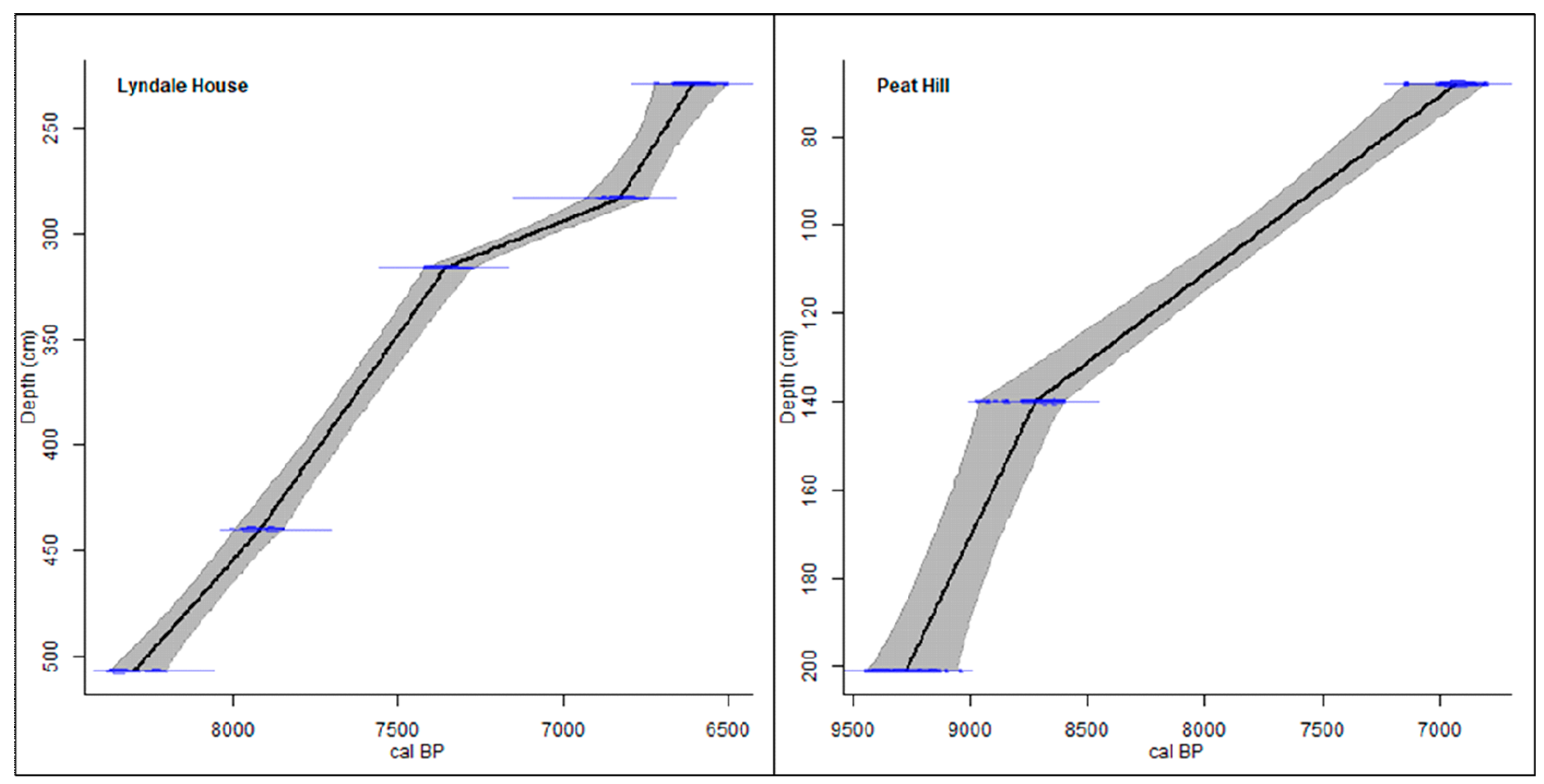
Age-depth models are presented in Figure 2. Between the earliest dated horizon at Lyndale House at 507 cm (−0.87 mOD) (8205–8386 cal BP (7497 ± 32)) and 440 cm (−0.20 mOD) (7485–7981 cal BP (7094 ± 36)) the sediment accumulation rate is 1.2 mm a−1. Between 440 cm and 316 cm (1.04 mOD) (7280–7426 cal BP (6436 ± 37)) the sediment accumulation rate increases to 3.3 mm a−1. Between 316 cm and 283 cm (1.37 mOD) (6739–6922 cal BP (5989 ± 33)) the sediment accumulation rate decreases to 0.6 mm a−1 and between 283 cm and the highest dated horizon at 229 cm (1.91 mOD) (6498–6716 cal BP (5808 ± 36)) the sediment accumulation increases again to 2.4 mm a−1. Between the earliest dated horizon at Peat Hill at 201 cm (73.00 mOD) (9117–9458 cal BP (8288 ± 59)) and the horizon dated at 140 cm (73.61 mOD) (8592–8793 cal BP (7892 ± 39)), the sediment accumulation rate is 1 mm a−1. Between the horizon dated at 140 cm and the highest dated horizon at 68 cm (74.33 mOD) (6793–7023 cal BP (6072 ± 41)) the sediment accumulation rate decreases to 0.4 mm a−1.
3.2. Lithostratigraphy
3.2.1. Lyndale House
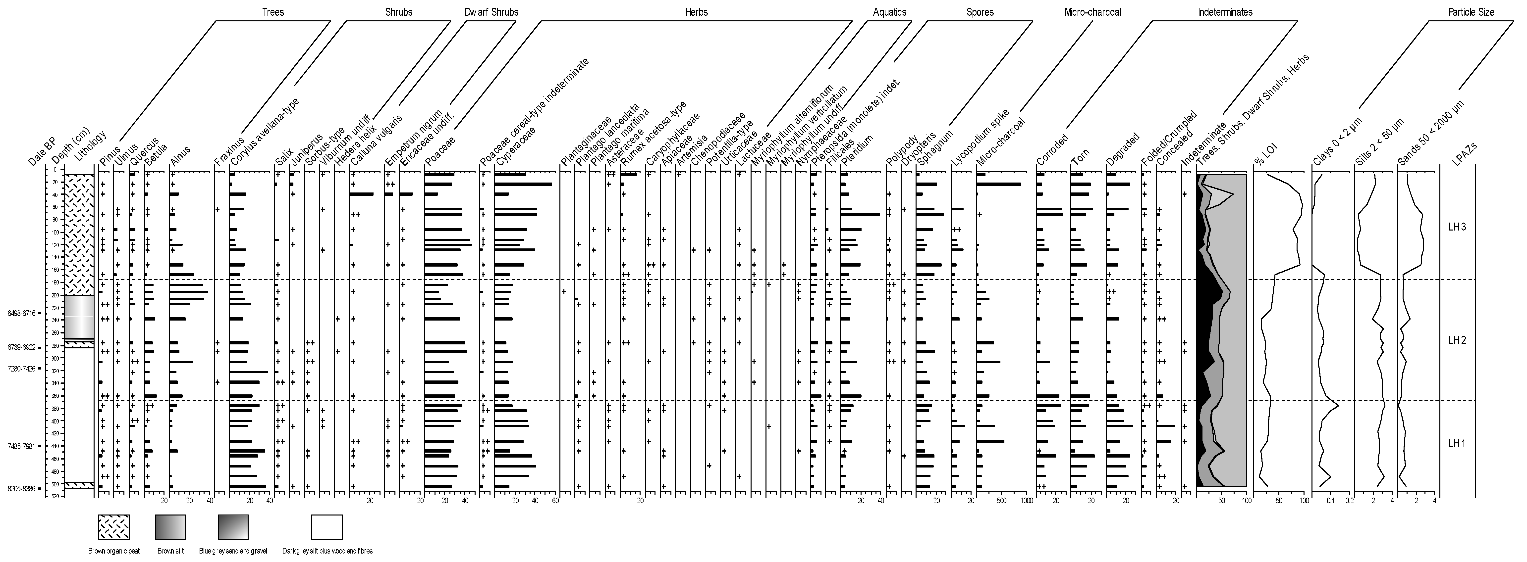
The core extracted at Lyndale House mainly consists of peat and silt sediments, with sand and gravel horizons (Table 2). The sediments are dominated by silt sized fractions between 504 cm and 168 cm (up to 82%), sand sized fractions (up to 89%) between 152 cm and 72 cm and silt sized fractions between 40 cm to 8 cm (up to 63%). The organic content of the sediments (LOI) range from 9.8% to 91.5% (Figure 3). From the core base to 168 cm, where silts dominate the stratigraphy, the mean organic content is 25.5% with a range of 9.8% to 42.2%. There is a significant change in the organic content of the sediments at 152 cm where levels reach 91.5%. From 152 cm to the core surface, where peat sediments dominate the stratigraphy, the mean organic content is 79.7% with a range of 26.6% to 94.5%.
3.2.2. Peat Hill
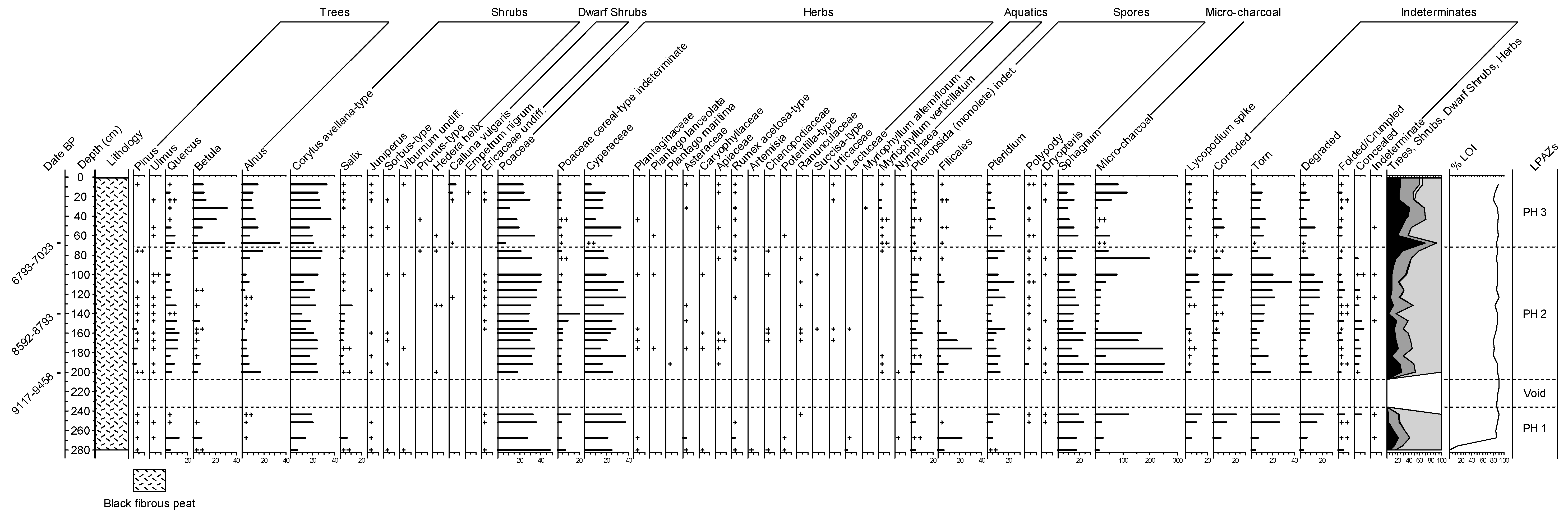
The sediment core extracted at Peat Hill consists entirely of black fibrous peat (Table 2). The organic content of the sediments average 84.4% with a range of 80.6% to 91.1% (Figure 4). The organic content generally shows limited variation throughout the stratigraphy, with the exception of the sample taken at 276 cm, which had an LOI value of 14.5%.
3.3. Pollen Analysis
The percentage pollen frequency plot for Lyndale House is presented in Figure 3 and the plot for Peat Hill is presented in Figure 4. LPAZ descriptions and palaeoenvironmental interpretations are presented in Table 3 and Table 4, with approximate ages based on the age-depth model which were extrapolated using CLAM [34]. The data for each site have been divided into three LPAZs (LH1–3) (PH1–3). Pollen was absent from Peat Hill at 236–208 cm (72.65–72.93 mOD) and the section has therefore not been zoned.
4. Discussion
4.1. Early Holocene Vegetation Changes
The pollen, spore and microcharcoal profile at Peat Hill commences in the early Holocene. The basal horizon is characterised by high levels of Poaceae and Cyperaceae pollen and low arboreal pollen values, indicating an open vegetational environment similar to that identified at Inver Aulavaig (Skye) (LPAZ IA3) [12,14,40,41]. From ca 9910 cal BP (270 cm), increased Corylus (hazel) pollen and fern spores indicate the development of hazel scrub or woodland and are concurrent with the timing of Corylus pollen expansion on the west coast of the Isle of Skye, recorded from 10,110 ± 140 cal BP; and at inland sites in Oban, from ca 9500 cal BP [12,42]. Corylus expansion appears to have been synchronous across much of southwest Scotland at this time, though it is recorded later in pollen diagrams inland on the Isle of Mull (8760 ± 140 BP) and the Isle of Arran (8665 ± 155 BP) [11,43]. Expansion coincides with the Holocene thermal maximum when the climate was generally warmer and drier [44].
4.1.1. The 9300 Cal BP Event
The hiatus in microfossil content of the sediments at Peat Hill from ca 9342–9599 cal BP (208–236 cm) makes it difficult to detect evidence of climatically induced vegetation changes relating to the 9300 cal BP event. The increase in microcharcoal levels from ca 9672 cal BP (244 cm) which resumes at 9117–9458 cal BP (201 cm), may be an indication of drier conditions associated with the climate change episode. The minor declines in cold-intolerant Quercus and Corylus pollen at ca 9122 cal BP (184 cm) may also indicate a vegetative response to lower temperatures.
4.1.2. Early Alnus Presence
From 9117–9458 cal BP (201 cm) (LPAZ PH2) there is an expansion in scrub/woodland coverage at Peat Hill as Betula and Quercus pollen increase. The sudden rather than gradual expansion in Alnus in this horizon is likely to be a consequence of the previous hiatus in pollen preservation. The presence of Alnus pollen at both Peat Hill and Lyndale House is very early compared to other studies in the region [7,37,43]. For example, there is no record of Alnus pollen in the late Glacial/early Holocene palaeoenvironmental records at Druim Loch (east Skye), Loch Ashik (east Skye) and Elgol [11]. Although Alnus pollen is recorded at ca 9740–9490 cal BP at Loch Cleat (north Skye) [13].
Macrofossil evidence of Alnus in the UK suggests that small stands of alder trees may have existed in Yorkshire during the Late Glacial and at 10,500 BP, and in Wales from 8900 BP [41,45]. Alnus has a high potential for seed dispersal via water [41] and it is possible that small stands of Alnus trees may have existed on the Isle of Bute and the Isle of Skye at this time via marine water seed transportation along the west coast. Given the lack of evidence for early Alnus pollen presence in the region, and that the abundance of the taxon declines to low levels for the remainder of the Early Holocene period at Peat Hill, it is highly unlikely that Alnus widely colonised the region until the mid Holocene.
4.1.3. Early Anthropogenic Influences
A peak in Poaceae (grass) cereal-type (7–14%) at 8592–8793 cal BP alongside a decrease in arboreal pollen may represent anthropogenic disturbance at Peat Hill. It is feasible to propose a human influence on the vegetation composition in the region given the lack of evidence for climate events at this time. Archaeological records of prehistoric human activities are also relatively abundant in the surrounding area, including a lithic working site of probable Mesolithic age close to Branzet Moss and several caves with midden deposits around Dunagoil Bay [46].
Cereal-type pollen has been identified in early Holocene pollen records in other parts of the region [42,47]. However, the large grains identified at Peat Hill are highly likely to represent wild grass species. Large pollen grain sizes, similar to cultivated taxa, may have colonised the area following clearance, potentially as a result of felling. It is generally accepted that adequate evidence of cereal cultivation in the region is not apparent until ca 5000 BP. Multiple palynological indicators of agriculture become apparent at this time and the earliest cereal macrofossil remains have been dated to this period. Palaeodietary and archaeological data show a concurrent shift to domesticated plant and animal subsistence in western Scotland [48,49,50].
4.1.4. The 8200 Cal BP Event
At Lyndale House, hazel scrub/woodland is already established at the base of the profile from 8205–8386 cal BP (507 cm). The Early Holocene vegetation bears similarity to Peat Hill, being dominated by Corylus, Cyperaceae, Poaceae and Sphagnum taxa, indicating wet acidic fen conditions [51]. The horizon is followed by a significant decrease in tree pollen as Poaceae and Cyperaceae increase, and the LOI percentage of the sediments decreases, indicating a drier more open environment which may have been affected by colder climatic conditions.
The effects of the 8200 cal BP event are less pronounced at Peat Hill, though the absence of Betula and Salix pollen from ca 8222 cal BP (120 cm) and the decrease in peat accumulation rates gives some indication of reduced temperatures and precipitation in the region. Arboreal pollen and microcharcoal presence increases at both sites from ca 7500 cal BP, indicating an increase in regional temperatures favouring woodland expansion, which corresponds with a wet shift in the palaeoclimatic record (at ca 7800 to 6800 cal BP) [44].
4.2. Mid Holocene Vegetation Changes
4.2.1. Alnus Colonisation
A main phase of Alnus expansion is evident at both sites during the mid Holocene. At Peat Hill, the expansion at 6793–7023 cal BP (68 cm) occurs alongside a significant increase in Betula pollen and low herb pollen levels. At Lyndale House, the increase after 6498–6716 cal BP (229 cm) occurs alongside the resumption of peat growth and a decrease in Poaceae and Cyperaceae coverage. Alnus expansion is generally concurrent across the region, commencing from 6630 ± 130 cal BP at Arran [43], from 6630 ± 70 cal BP at Talisker Bay and 6600 ± 70 at Peinchorran, Skye [12], and 6430 ± 90 cal BP on the Isle of Rhum [47]. An earlier rise is dated at Inver Aulavaig, Skye at 7640 ± 240 cal BP [12]. The Alnus rise in this period is generally attributed to regional increased precipitation [44,51]. Alnus may have colonised the islands from the mainland [36] and the earlier expansion at Bute, compared to Skye, may indicate later colonisation of more northern sites. Alternatively, the expansion of Alnus at Lyndale House may reflect succession from a turbid marine environment, indicated by the horizon of silt sediments from 270 cm to 200 cm, to fen or marsh following barrier development at the site.
Mid Holocene Alnus expansion is followed by a reduction in the abundance of the taxon at both sites. At Lyndale House, the decline occurs alongside a decrease in arboreal pollen which remains low for the remainder of the profile. The concurrent increase in Poaceae and Cyperaceae pollen in the period reflects a change in the vegetation composition of the site from hazel, alder and birch scrub to open grassland with some areas of hazel and alder scrub. The reduction in Alnus abundance at Peat Hill is temporary, and occurs alongside concurrent temporary increases in Cyperaceae and Poaceae pollen. For the remainder of the period, Alnus pollen abundance sees some recovery alongside high levels of Corylus and fluctuating Betula pollen, signalling increased woodland coverage of the area in the mid Holocene. There may be some evidence of increased acidification of the sediments at Lyndale House and Peat Hill towards the mid to late Holocene, indicated by the increased levels of ericaceous pollen at both sites. Increased acidification is thought to be a regional event related to higher precipitation rates and stronger winds at ca. 3000 BP [12].
4.2.2. Anthropogenic Influences on Vegetation
Potential signals of anthropogenic disturbance in the palynological record at Lyndale House are subtle and difficult to decipher from synchronous environmental changes associated with climate and reduced marine influence on the landscape from ca. 6498–6716 cal BP (229 cm). The archaeological record indicates the presence of Mesolithic populations in the area and sites consisting of middens, hearths and lithic scatters, have been identified in many coastal areas of the island, including at nearby South Cuidrach [46]. The incidence of anthropogenic indicator taxa such as Plantago lanceolata and herbs of the Apiaceae and Asteraceae families [44,46], alongside increased microcharcoal levels, may suggest small-scale disturbance activities in the surrounding landscape early in the sequence (ca. 7485–7981 cal BP) [35,37,52]. Green and Edwards [13] suggest that human woodland interference may be evident at Digg (northern Trotternish, Skye) from 8350–6850 BP when herb pollen and microcharcoal levels increase. However, at Oban (Argyll), increased microcharcoal levels observed at a similar period (8100 BP) are assigned to a drier climatic episode [42], highlighting the difficulty in deciphering subtle signals of anthropogenic disturbance against a background of changing environmental conditions. Where large diameter Poaceae pollen is present in the Lyndale House sequence, counts are low until the small and isolated peak following the onset of peat formation (which coincides with a heightened episode of burning), and the shift to a freshwater environment with the landward site being cut off from the sea [16]. It may be feasible that the culmination of climatic, marine, and hydrological improvements enabled and/or encouraged small-scale vegetation manipulation at the coastal site, particularly as a consequence of the cessation of sea-level rise after 6498–6716 cal BP (5808 ± 36) [16].
The decrease in arboreal pollen levels at Lyndale House from ca. 5078 cal BP is likely to reflect the onset of regional woodland clearance, which commenced at many other areas of Skye in the same period [13,14,53]. Microcharcoal levels are low throughout this period, indicating clearance by felling and sustained grazing pressures which resulted in the almost continuous reduction in arboreal pollen levels for the remainder of the Lyndale House profile. By ca 2000 cal BP, it is likely that much of the region would have been subject to considerable deforestation from the combined effects of the changing climate, human influences and edaphic changes [53].
The rise in large diameter Poaceae pollen from ca 3207 cal BP (32 cm) at Peat Hill, which occurs alongside small increases in ruderal pollen, increased microcharcoal levels, and a decrease in arboreal pollen, most likely indicates the advent of widespread agrarian practices in the area. The onset of the episode may coincide with the establishment of Dunagoil Fort in the Iron Age period [54]. An anthropogenic influence is strongly apparent in the Lyndale House sequence later, from ca. 693 cal BP (the upper 24 cm of the profile). Disturbance is marked by a rise in Rumex, Cyperaceae and Poaceae pollen, alongside reduced arboreal pollen, peak microcharcoal levels and a reduced organic matter content. The onset of the episode may reflect medieval and post-medieval pastoral agricultural expansion in the area which is indicated in the archaeological record by the presence of several shieling huts, including at nearby Breabost [46].
5. Conclusions
New palaeoenvironmental data for a low-lying coastal site on the Isle of Skye and an inland highland site on the Isle of Bute, West Scotland, reveals complex vegetation changes in the early to mid Holocene which can be associated with changing climate, human influences, marine conditions and edaphic changes. There are subtle indications that the 8200 cal BP climate event had an effect on the vegetation composition at both sites, while the period of heightened microcharcoal levels from ca 9672 cal BP (244 cm) at Peat Hill (Bute) may indicate the effects of the cooler drier climate event of ca 9300 cal BP.
Signals of anthropogenic woodland clearance are apparent early in the sequence at Peat Hill, indicated by a peak in Poaceae (grass) cereal-type (7–14%) at 8592–8793 cal BP, alongside a decrease in arboreal pollen, which could not be associated with a regional episode of climate change. Archaeological records of Mesolithic sites are relatively abundant in the area surrounding Peat Hill, including a lithic working site of probable Mesolithic age close to Branzet Moss and several caves with midden deposits around Dunagoil Bay.
Early to mid Holocene vegetation changes at Lyndale House (Skye) occur alongside regional changes in precipitation and sea level and therefore cannot be readily separated. Continuous declines in arboreal pollen from ca. 5000 cal BP at Lyndale House indicates the onset of widespread clearance in the region via felling and sustained grazing pressures.
Author Contributions
K.A.S. designed the study, undertook all the fieldwork and some lab analyses. J.W. undertook the pollen analyses and plotted the data. The writing up and figures were completed by J.W., K.A.S. and S.D. All authors have read and agreed to the published version of the manuscript.
Funding
The study was funded by the first author.
Data Availability Statement
Not applicable.
Acknowledgments
The authors would like to thank the following; James Wells, Peter Benbow, Graham Hambley and Tom Holmes for their help with fieldwork and Maria Gehrels for technical support in the laboratory. Kevin Kearney for undertaking additional pollen extraction, and Mark Wheeler for his IT and software support.
Conflicts of Interest
The authors declare no conflict of interest.
References
- Huntley, B.; Baillie, M.; Grove, J.M.; Hammer, C.U.; Harrison, S.P.; Jacomet, S.; Jansen, E.; Karlén, W.; Koç, N.; Luterbacher, J.; et al. Holocene palaeoenvironmental changes in North-West Europe: Climatic implications and the human dimension. In Climate Development and History of the North Atlantic Realm; Wefer, G., Berger, W., Behre, K.E., Jansen, E., Eds.; Springer Science & Business Media: Berlin/Heidelberg, Germany, 2002; pp. 259–298. [Google Scholar]
- Wiersma, A.P.; Renssen, H. Model–data comparison for the 8.2 ka BP event: Confirmation of a forcing mechanism by catastrophic drainage of Laurentide Lakes. Quat. Sci. Rev. 2016, 25, 63–88. [Google Scholar] [CrossRef]
- Alley, R.B.; Mayewski, P.A.; Sowers, T.; Stuiver, M.; Taylor, K.C.; Clark, P.U. Holocene climatic instability: A prominent, widespread event 8200 yr ago. Geology 1997, 25, 483–486. [Google Scholar] [CrossRef]
- Fisher, T.G.; Smith, D.G.; Andrews, J.T. Preboreal oscillation caused by a glacial Lake Agassiz flood. Quat. Sci. Rev. 2002, 21, 873–878. [Google Scholar] [CrossRef]
- Rasmussen, S.O.; Vinther, B.M.; Clausen, H.B.; Andersen, K.K. Early Holocene climate oscillations recorded in three Greenland ice cores. Quat. Sci. Rev. 2007, 26, 1907–1914. [Google Scholar] [CrossRef] [Green Version]
- Edwards, K.J.; Langdon, P.G.; Sugden, H. Separating climatic and possible human impacts in the early Holocene: Biotic response around the time of the 8200 cal. yr BP event. J. Quat. Sci. 2007, 22, 77–84. [Google Scholar] [CrossRef]
- Wicks, K.; Mithen, S. The impact of the abrupt 8.2 ka cold event on the Mesolithic population of western Scotland: A Bayesian chronological analysis using ‘activity events’ as a population proxy. J. Arch. Sci. 2014, 45, 240–269. [Google Scholar] [CrossRef]
- Vasari, Y.; Vasari, A. Late and Postglacial macrophytic vegetation in the lochs of Northern Scotland. Acta. Bot. Fenn. 1968, 80, 1–20. [Google Scholar]
- Birks, H.J.B. Past and Present Vegetation of the Isle of Skye. A Palaeoecological Study; Cambridge University Press: London, UK, 1973. [Google Scholar]
- Williams, W. The Flandrian Vegetational History of the Isle of Skye and the Morar Peninsula. Ph.D. Thesis, University of Cambridge, Cambridge, UK, 1977. [Google Scholar]
- Walker, M.J.C.; Lowe, J.J. Reconstructing the environmental history of the Last Glacial-Interglacial transition: Evidence from the Isle of Skye. Quat. Sci. Rev. 1990, 9, 15–49. [Google Scholar] [CrossRef]
- Selby, K.A. Lateglacial and Holocene vegetation change on the Isle of Skye: New data from three coastal locations. Veget. Hist. Archaeobot. 2004, 13, 233–247. [Google Scholar] [CrossRef]
- Green, F.; Edwards, K. 8.1 Palynological Studies in Northeast Skye and Raasay. Scott. Archaeol. Internet. Rep. 2009, 481–490. Available online: http://journals.socantscot.org/index.php/sair/article/view/2176 (accessed on 15 September 2019).
- Birks, H.J.B.; Williams, W. Late Quaternary vegetation history of the Inner Hebrides. Proc. R. Soc. Edinb. 1983, 83, 269–292. [Google Scholar]
- Met Office. Skye: Prabost, 1981–2010. NDa. Available online: https://www.metoffice.gov.uk/research/climate/maps-and-data/uk-climate-averages/gf5wbt9v5 (accessed on 9 June 2021).
- Selby, K.A.; Smith, D.E. Raised shorelines and sea-level change on Skye. In The Quaternary of Skye Field Guide; Ballantyne, C.K., Lowe, J.J., Eds.; Quaternary Research Association: London, UK, 2016; pp. 89–111. [Google Scholar]
- Whittington, D. Environmental conditions at Hilton. Trans. Buteshire. Nat. Hist. Soc. 1976, 20, 23–26. [Google Scholar]
- Timpany, S.; Wheeler, J. Understanding past landscapes: An 11000 year palaeoenvironmental history for the Isle of Bute. In One Island, Many Voices: Bute, Archaeology and the Discover Bute Landscape Partnership Scheme; Duffy, P.R.J., Ed.; Shaun Tyas/Discover Bute Landscape Partnership Scheme, Donington: Derby, UK, 2012; pp. 19–30. [Google Scholar]
- Met Office. Bute: Rothesay, 1981–2010. NDa. Available online: https://www.metoffice.gov.uk/research/climate/maps-and-data/uk-climate-averages/gcumthbh6 (accessed on 9 June 2021).
- Troels-Smith, J. Characterization of Unconsolidated Sediments. CA Reitzels Forlag, Axel Sandal: Geological Survey of Denmark IV; CA Reitzels Forlag: Copenhagen, Denmark, 1955; Volume 3, No 10; pp. 38–71. [Google Scholar]
- Jowsey, P.C. An improved peat sampler. New Phytol. 1966, 64, 245–248. [Google Scholar] [CrossRef]
- Barber, K.E. History of Vegetation. In Methods in Plant Ecology; Chapman, S.B., Ed.; Blackwell: Oxford, UK, 1976; pp. 5–83. [Google Scholar]
- Moore, P.D.; Webb, J.A.; Collinson, M.E. Pollen Analysis, 2nd ed.; Blackwell Science: London, UK, 1999. [Google Scholar]
- Reille, M. Pollen et Spores d’Europe et d’Afrique du Nord, 2nd ed.; Laboratoire de Botanique Historique et Palynologie: Marseille, France, 1999. [Google Scholar]
- Beug, H.J. Leitfaden der Pollenbestimmung für Mitteleuropa und Angrenzende Gebiete; Verlag Dr Friedrich Pfeil: Munich, Germany, 2004. [Google Scholar]
- Edwards, K.J. The separation of Corylus and Myrica pollen in modern and fossil samples. Poll. Spor. 1981, 23, 205–218. [Google Scholar]
- Stace, C. New Flora of the British Isles, 3rd ed.; Cambridge University Press: Cambridge, UK, 2014. [Google Scholar]
- Grimm, E.C. TGView 2.1.1. Illinois State Museum, Illinois. 2018. Available online: http://www.TiliaIT.com (accessed on 15 September 2019).
- Grimm, E.C. CONISS: A FORTRAN 77 program for stratigraphically constrained cluster analysis by the method of incremental sum of squares. Comput. Geosci. 1987, 13, 13–35. [Google Scholar] [CrossRef]
- Heiri, O.; Lotter, A.F.; Lemcke, G. Loss on ignition as a method for estimating organic and carbonate content in sediments: Reproducibility and comparability of results. J. Paleolimnol. 2001, 25, 101–110. [Google Scholar] [CrossRef]
- Wentworth, C.K. A scale of grade and class terms for clastic sediments. J. Geol. 1922, 30, 377–392. [Google Scholar] [CrossRef]
- Friedman, G.M.; Sanders, F.E. Principles of Sedimentology; Wiley: New York, NY, USA, 1978. [Google Scholar]
- Stuiver, M.; Reimer, P.J.; Reimer, R. CALIB7.1 [WWW program] at. 2018. Available online: http://calib.org (accessed on 15 September 2019).
- Blaauw, M. Methods and code for ‘classical’ age-modelling of radiocarbon sequences. Quat. Geochronol. 2010, 5, 512–518. [Google Scholar] [CrossRef]
- Behre, K.E. The interpretation of anthropogenic indicators in pollen diagrams. Poll. Spor. 1981, 23, 225–245. [Google Scholar]
- Behre, K.E. Evidence for Mesolithic agriculture in and around Central Europe? Veget. Hist. Archaeobot. 2007, 16, 203–219. [Google Scholar] [CrossRef] [Green Version]
- Brown, A.G.; Carpenter, R.G.; Walling, D.E. Monitoring fluvial pollen transport, its relationship to catchment vegetation and implications for palaeoenvironmental studies. Rev. Palaeobot. Palynol. 2007, 147, 60–76. [Google Scholar] [CrossRef] [Green Version]
- Waller, M.P.; Binney, H.A.; Bunting, M.J.; Armitage, R.A. The interpretation of fen carr pollen diagrams: Pollen-vegetation relationships within the fen carr. Rev. Palaeobot. Palynol. 2005, 133, 179–202. [Google Scholar] [CrossRef]
- McCarroll, J.; Chambers, F.M.; Webb, J.C.; Thom, T. Informing innovative peatland conservations in light of palaeoecological evidence for the demise of Sphagnum imbricatum: The case of Oxenhope Moor, Yorkshire, UK. Mires. Peat. 2016, 18, 1–24. [Google Scholar]
- Smith, A.G.; Pilcher, J.R. Radiocarbon dates and vegetation history of the British Isles. New. Phytol. 1973, 72, 903–914. [Google Scholar] [CrossRef]
- Birks, H.J.B. Holocene isochrone maps and patterns of tree-spreading in the British Isles. J. Biogeogr. 1989, 16, 503–540. [Google Scholar] [CrossRef]
- Macklin, M.G.; Bonsall, C.; Davies, F.M.; Robinson, M.R. Human-environment interactions during the Holocene: New data and interpretations from the Oban area, Argyll, Scotland. Holocene 2000, 10, 109–121. [Google Scholar] [CrossRef]
- Robinson, D.E.; Dickson, J.H. Vegetational history and land use: A radiocarbon-dated pollen diagram from Machrie Moor, Arran, Scotland. New Phytol. 1988, 109, 223–251. [Google Scholar] [CrossRef]
- Hughes, P.D.M.; Mauquoy, D.; Barber, K.E.; Langdon, P.G. Mire-development pathways and palaeoclimatic records from a full Holocene peat archive at Walton Moss, Cumbria, England. Holocene 2000, 10, 465–479. [Google Scholar] [CrossRef]
- Young, D.S.; Green, C.P.; Batchelor, C.R.; Austin, P.; Elias, S.A.; Athersuch, J. Macrofossil evidence of alder (Alnus sp.) in Britain early in the Late Glacial Interstadial: Implications for the northern cryptic refugia debate. J. Quat. Sci. 2021, 36, 40–55. [Google Scholar] [CrossRef]
- Historic Environment Scotland. Canmore. NDa. Available online: https://canmore.org.uk/ (accessed on 22 November 2022).
- Hirons, K.R.; Edwards, K.J. Pollen and related studies at Kinloch, Isle of Rhum, Scotland, with particular reference to possible early human impacts on vegetation. New Phytol. 1990, 116, 715–727. [Google Scholar] [CrossRef]
- Bonsall, C.; Anderson, D.E.; Macklin, M.G. The Mesolithic-Neolithic transition in western Scotland and its European context. Doc. Praehist. 2002, 29, 1–25. [Google Scholar] [CrossRef]
- Schulting, R.J.; Richards, M.P. The wet, the wild and the domesticated: The Mesolithic–Neolithic transition on the west coast of Scotland. Euro. J. Archaeol. 2002, 5, 147–189. [Google Scholar]
- Brown, A. Dating the onset of cereal cultivation in Britain and Ireland: The evidence from charred cereal grains. Antiquity 2007, 81, 1042–1052. [Google Scholar] [CrossRef]
- Tipping, R.M. Storminess as an explanation for the decline of pine woodland ca. 7400 years ago at Loch Tulla, western Scotland. Veget. Hist. Archaeobot. 2008, 17, 345–350. [Google Scholar] [CrossRef]
- Simmons, I.G. Towards an ecology of Mesolithic man in the uplands of Great Britain. J. Archaeol. Sci. 1975, 2, 1–5. [Google Scholar] [CrossRef]
- Tipping, R.M. The form and fate of Scotland’s woodlands. Proc. Soc. Antiq. Scot. 1994, 124, 1–54. [Google Scholar]
- Alexander, D. The Time of the Duns: Late Bronze Age and Iron Age Bute. In One Island, Many Voices: Bute, Archaeology and The Discover Bute Landscape Partnership Scheme; Duffey, P.R.J., Ed.; Paul Watkins Publishing: Donington, UK, 2012; pp. 73–88. [Google Scholar]
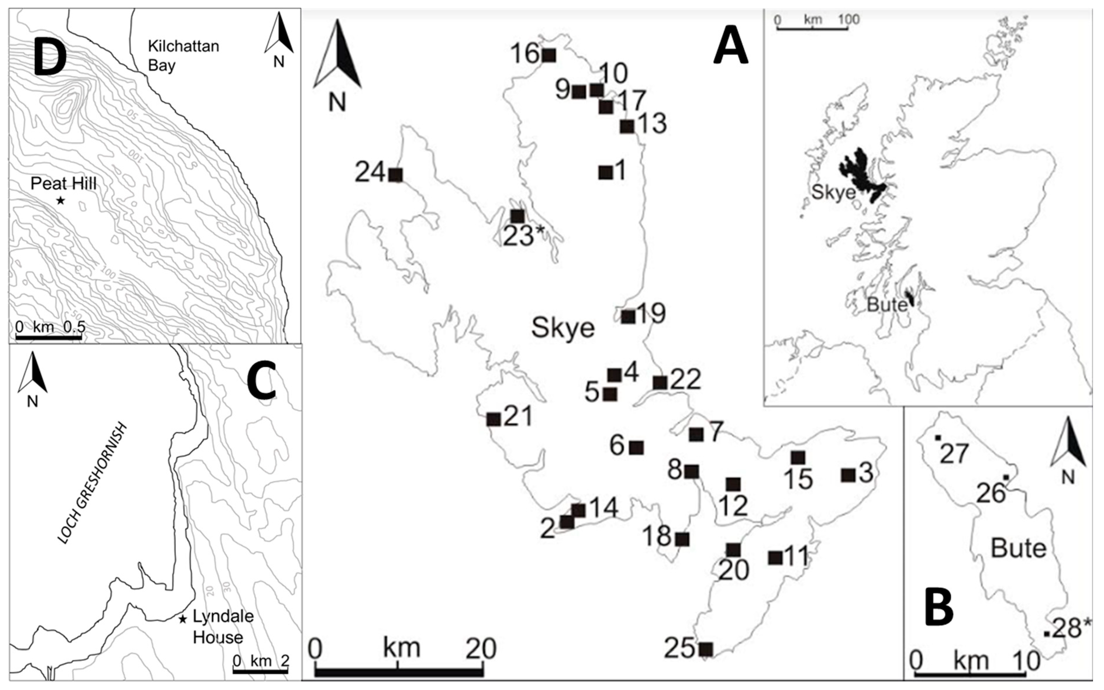
Figure 1.
Map to show the location of the study sites (*) at Skye (A) and Bute (B) alongside topographic maps of the study sites (Lyndale House, (C); Peat Hill, (D)). The locations of previous palaeoecological investigations are also shown: (A) Skye: 1 Loch Cuithir, 2 Slochd Dubh, 3 Glen Arroch, 4 Glen Varragill, 5. Sligachan, 6 Marsco, 7 Luib 1 & 2, 8 Clach Oscar, 9 Loch Fada, 10 Digg, 11 Loch Meodal, 12 Loch Cill Chroisd, 13 Loch Mealt, 14 Lochan Coir’ a’ Ghobhainn, 15 Loch Ashik, 16 Loch Cleat, 17 Suarbie, 18 Elgol (Glasnakille), 19 Druim Loch, 20 Inver Aulavaig, 21 Talisker Bay, 22 Peinchorran 23 Lyndale House*, 24 Ardmore Bay, 25 Point of Sleat (B) Bute: 26 Hilton, 27 Red Loch, 28 Peat Hill*. * Indicates new data presented in this paper.

Figure 2.
Age-depth models for Lyndale House, Skye and Peat Hill, Bute.

Figure 3.
Percentage pollen frequency diagram for Lyndale house, Skye.

Figure 4.
Percentage pollen frequency diagram for Peat Hill, Bute.


Table 1.
Radiocarbon dates used in this study.
| Site | Lab Code | Depth (cm) | mOD | C13:C12 (‰) | 14C age BP 1σ (* = AMS date) | 14C Age Range cal.BP 2σ | Horizon/Material Dated | Reference [16] |
|---|---|---|---|---|---|---|---|---|
| LH 1 | UBA-23234 | 229 | 1.91 | −23.9 | 5808 ± 36 | 6498–6716 | Silt | Selby & Smith (2016) |
| LH | UBA-23235 | 283 | 1.37 | −21.9 | 5989 ± 33 | 6739–6922 | Silt, sand & gravel lens | Selby & Smith (2016) |
| LH | UBA-23236 | 316 | 1.04 | −17.0 | 6436 ± 37 | 7280–7426 | Silt with wood & fibres | Selby & Smith (2016) |
| LH | UBA-23237 | 440 | −0.20 | −21.6 | 7094 ± 36 | 7485–7981 | Silt with wood & fibres | Selby & Smith (2016) |
| LH | UBA-23238 | 507 | −0.87 | −26.4 | 7497 ± 32 | 8205–8386 | Peat | Selby & Smith (2016) |
| PH 2 | D-AMS 029587 | 68 | 74.33 | −47.5 | 6072 ± 41 | 6793–7023 | Peat | New data |
| PH | D-AMS 029588 | 140 | 73.61 | −43.6 | 7892 ± 39 | 8592–8793 | Peat | New data |
| PH | D-AMS 029589 | 201 | 73.00 | −41.3 | 8288 ± 59 | 9117–9458 | Peat | New data |
1 Lyndale House, 2 Peat Hill.
Table 2.
Lithostratigraphic description of the sediment cores extracted at Lyndale House and Peat Hill.
Table 2.
Lithostratigraphic description of the sediment cores extracted at Lyndale House and Peat Hill.
| Site | Altitude (mOD) | Depth (cm) | Sedimentary Description |
|---|---|---|---|
| Lyndale House | 4.20–2.20 | 0–200 | Brown organic fibrous peat |
| 2.20–1.50 | 200–270 | Brown silt | |
| 1.50–1.46 | 270–274 | Blue-grey coarse sand & gravel | |
| 1.46–1.37 | 274–283 | Brown organic peat | |
| 1.37–1.36 | 283–284 | Blue-grey sand and gravel | |
| 1.36–−0.78 | 284–498 | Dark grey silt with wood & fibres | |
| −0.78–−0.87 | 498–507 | Brown organic peat | |
| −0.87 | 507 | Base | |
| Bute | |||
| Peat Hill | 75.00–71.89 | 0–312 | Black fibrous peat |
| 71.89 | 312 | Base |
Table 3.
LPAZ description and palaeoenvironmental interpretation for Lyndale House, Skye.
| Pollen Zone | mOD/Depth | LPAZ Description: Pollen Characteristics | Interpretation | Approximate Age (cal BP) |
|---|---|---|---|---|
| LH3 | 4.20–2.44 0–176 | Fluctuating dominance of Poaceae and Cyperaceae. Low arboreal pollen levels from mid-zone with decreasing Alnus (25–1%) and C. avellana-type (15–2%). Low Poaceae >35µm but occasionally above rare-type quantification (3%). Isolated peak in C. vulgaris (23%). Appearance of Juniperus above rare-type (3–4%) immediately after decline of C. vulgaris. Influx of R. acetosa-type (3–16%) at top of zone. Spores. Low microcharcoal counts to top of zone corresponding with decline of C. avellana-type (23–0.5%). Low herb mosaic. | Sedge fen with C. avellana-type and Alnus scrub. The presence of R. acetosa-type may indicate local anthropogenic disturbance [35,36,37]. The 885% influx and microcharcoal maximum at 24 cm (3.96 mOD) corresponding with decreases in C. avellana-type, Ericaceous taxa and Pteridium spores, may indicate elevated burning and a subsequent reduction in vegetation cover. | 231–5078 |
| LH2 | 2.44–0.52 176–368 | Fluctuating and gradual decrease of C. avellana-type (39–11%) from mid-zone. Fluctuating Alder (6–37%) and Betula (4–10%). Decreasing Cyperaceae (17–13%). Fluctuations in microcharcoal with peaks corresponding with decreases in C. avellana-type and increases in Alnus. Low herb mosaic. | C. avellana-type scrub with Alder, Betula and Poaceae. The formation of the 9 cm band of peat between 283–274 cm (1.37–1.46 mOD), and the increase in sediment accumulation rates between 283–229 cm (1.37–1.91 mOD) (2.4 mm a−1), indicates a further change in marine and associated hydrological conditions favouring organic deposition. The overlying 4 cm sand and gravel facies between 274–270 cm (1.46–1.50 mOD) may represent a final high energy marine environment after 6739–6922 cal BP (5989 ± 33). As peat continues to develop, the influx of Alnus pollen may represent the establishment of local fen carr [38]. The 50% increase in microcharcoal at 360 cm (0.60 mOD) corresponds with increases in in Betula, Alnus and P. lanceolata, which may be a response to this episode of burning. | 5078–6763 |
| LH1 | 0.52–-0.87 368–507 | Fluctuating Betula (6–12%) and Alnus (4–13%). Dominance of C. avellana-type (36–23%) showing similar fluctuation patterns. Microcharcoal fluctuations (91–556%) correspond with reductions and influxes in pollen counts. Fluctuating Poaceae (27–37%) and Cyperaceae (14–34%). Low shrubs (with the exception of C. avellana-type), dwarf shrubs, and herb mosaic. | C. avellana-type scrub with Betula, Alnus, Salix, and Quercus. Poaceae >35µm is present at −0.84 mOD as a rare-type. Large diameter Poaceae pollen may represent cereals or wild grass. The maximum microcharcoal peak in this zone at 432 cm (−0.12 m OD) coincides with a 14% increase in Cyperaceae pollen. The subsequent and isolated peak in Poaceae >35 µm counts at 408 cm (0.12 mOD) may be a response to clearance following burning or increased anthropogenic activity. | 6763–8301 |
Table 4.
LPAZ description and palaeoenvironmental interpretation for Peat Hill, Bute.
| Pollen Zone | mOD/Depth | LPAZ Description: Pollen Characteristics | Interpretation | Approximate Age (cal BP) |
|---|---|---|---|---|
| PH3 | 75.00–74.29 0–72 | C. avellana-type (17–33%) with low and high fluctuations corresponding with high and low microcharcoal fluctuations. Betula (4–21%) and Alnus (8–33%) peaks correspond with low microcharcoal counts. Fluctuating Poaceae (7–34%) decreasing mid-zone (17%), then increasing (23–29%). Cyperaceae to rare-type increases temporarily (24–33%) prior to decline (18–6%) in upper half of zone. Appearance of C. vulgaris (4–6%) corresponds with an increase in microcharcoal counts (116–84%) in upper levels of zone. Influx of aquatic M. verticillatum to above rare-type status (3%) in top half of zone. Low herb mosaic. | Poaceae and Cyperaceae dominated grassland and C. avellana-type dominated scrub with Alnus and Betula. The influx of C. vulgaris pollen to 6% at 8 cm may indicate increased soil acidity and a regional increase in precipitation [12]. Pollen which may potentially indicate anthropogenic disturbance includes rare-type quantities of Plantaginaceae/P. lanceolata, R. acetosa-type, Asteraceae, Apiaceae, Potentilla, and Urticaceae [35,37]. These taxa are representative of grassland, most probably meadow or pasture [35,37]. | 802–7030 |
| PH2 | 74.29–72.93 72–208 | Gradual increase in Poaceae (18–40%) and Poaceae >35µm (3–7%). Fluctuating Cyperaceae (14–38%). Fluctuating dominant C. avellana-type (11–29%). Fluctuating Quercus (2–12%). Lesser and fluctuating quantities of Betula (2–9%) and Alnus (1–18%). Temporary increase of Sphagnum in bottom third of zone corresponding with high microcharcoal counts. High microcharcoal counts in bottom third of zone (165–244%), declining mid-zone (4–33%), increasing (194%) prior to decline (42%) at upper PH2 boundary. Low herb mosaic. | Poaceae and Cyperaceae dominated grassland and C. avellana-type dominated scrub with Quercus. Filicales spores reach their maximum at 176 cm (73.25 mOD), whilst Sphagnum declines to its lowest count (12%). The fluctuations of these two spores at this depth may be a response to the initial phase of elevated burning [39]. However, there is no notable impact across the pollen assemblage until 156 cm (73.45 mOD) when microcharcoal counts decline to 4% and Poaceae cereal-type starts to rise. This fluctuation in herbaceous taxa may represent a temporary expansion of wild grass following a phase of elevated burning. | 7030–9342 |
| VOID | 72.93–72.65 208–236 | Zone void of microfossils. | The cause of this data void cannot be defined. Loss-on-ignition percentages show a consistent organic content of 86–90%. | 9342–9599 |
| PH1 | 72.65–71.89 236–312 | Fluctuating Poaceae (27–48%) (including Poaceae >35µm (3–12%)) and Cyperaceae (21–38%). Increase in C. avellana-type (5–20%). Initial increase in Quercus (4–12%), Betula (2–7%), and Salix (2–6%) followed by decline of Quercus to 0.3%, and disappearance of Betula and Salix. Low shrub and herb mosaic. Increase in microcharcoal (11–117%). | Poaceae and Cyperaceae dominated grassland Low arboreal values indicate an open early Holocene vegetational environment. The microcharcoal peak at 244 cm (72.57 mOD) may indicate a phase of elevated burning. | 9599–10,294 |
Disclaimer/Publisher’s Note: The statements, opinions and data contained in all publications are solely those of the individual author(s) and contributor(s) and not of MDPI and/or the editor(s). MDPI and/or the editor(s) disclaim responsibility for any injury to people or property resulting from any ideas, methods, instructions or products referred to in the content. |
© 2023 by the authors. Licensee MDPI, Basel, Switzerland. This article is an open access article distributed under the terms and conditions of the Creative Commons Attribution (CC BY) license (https://creativecommons.org/licenses/by/4.0/).
Share and Cite
MDPI and ACS Style
Selby, K.A.; Wheeler, J.; Derrett, S. Disentangling Holocene Climate Change and Human Impact from Palaeoenvironmental Records from the Scottish West Coast. Quaternary 2023, 6, 2. https://doi.org/10.3390/quat6010002
AMA Style
Selby KA, Wheeler J, Derrett S. Disentangling Holocene Climate Change and Human Impact from Palaeoenvironmental Records from the Scottish West Coast. Quaternary. 2023; 6(1):2. https://doi.org/10.3390/quat6010002
Chicago/Turabian StyleSelby, Katherine A., Jane Wheeler, and Sally Derrett. 2023. "Disentangling Holocene Climate Change and Human Impact from Palaeoenvironmental Records from the Scottish West Coast" Quaternary 6, no. 1: 2. https://doi.org/10.3390/quat6010002