Article

Lateglacial to Mid-Holocene Vegetation History in the Eastern Vale of Pickering, Northeast Yorkshire, UK: Pollen Diagrams from Palaeolake Flixton

1
Geography Department, Durham University, Science Labs, South Road, Durham DH1 3LE, UK
2
Department of History and Archaeology, University of Chester, Parkgate Road, Chester CH1 4BJ, UK
*
Author to whom correspondence should be addressed.
Quaternary 2022, 5(4), 52; https://doi.org/10.3390/quat5040052
Submission received: 31 October 2022 / Revised: 28 November 2022 / Accepted: 28 November 2022 / Published: 8 December 2022
(This article belongs to the Special Issue Climate Change and Vegetation Evolution during the Holocene)

Abstract

:
Palaeolake Flixton, in the eastern Vale of Pickering in northeast Yorkshire, UK, existed as open water during the Lateglacial and early to mid-Holocene, until hydroseral succession and gradual terrestrialisation changed it to an area of fen and basin peatland by the later mid-Holocene. The environs of the lake were occupied by Late Palaeolithic and Mesolithic people over thousands of years and many Early Mesolithic sites, in particular, have been found located along the ancient lake edge, including the paradigm site for the British Early Mesolithic at Star Carr, where occupation occurred over several centuries. We have analysed eleven sediment cores, distributed in most parts of the palaeolake area, for pollen and stratigraphic data with which to reconstruct lake development and vegetation history. These new diagrams augment earlier pollen studies from the western part of the lake, particularly in the Star Carr area and near other major Mesolithic sites around Seamer Carr. Especially informative are a long core from the deepest part of the lake; cores that document the Lateglacial as well as early Holocene times, and evidence for the later Mesolithic that helps to balance the high density of Late Mesolithic sites known from research in the adjacent uplands of the North York Moors. There are many records of charcoal in the deposits but, especially for the earliest examples, it is not always possible to tie them firmly to either human activity or natural causes. Overall, the new and previously existing diagrams provide evidence for the spatial reconstruction of vegetation history across this important wetland system, including (a) for the progression of natural community successions within the wetland and on the surrounding dryland (b) the influence of climate change in bringing about changes in woodland composition and (c) for discussion of the possibility of human manipulation of the vegetation in the Late Upper Palaeolithic, Early and Late Mesolithic. Results show that climate was the main driver of longer-term vegetation change. Centennial-scale, abrupt climate events caused significant vegetation reversals in the Lateglacial Interstadial. The Lateglacial vegetation was very similar throughout the lake hinterland, although some areas supported some scrubby shrub rather than being completely open. Immigration and spread of Holocene woodland taxa comprised the familiar tree succession common in northern England but the timings of the establishment and the abundance of some individual tree types varied considerably around the lake margins because of edaphic factors and the effects of fire, probably of human origin. Woodland successions away from proximity to the lake were similar to those recorded in the wider landscape of northern England and produced a dense, homogenous forest cover occasionally affected by fire.

1. Introduction

The eastern Vale of Pickering in northeast Yorkshire has been the scene of intensive archaeological and palaeoenvironmental research since the mid-20th century [1,2,3,4,5,6,7] because of its rich Early Mesolithic archaeological resource, both lithic and organic. Much of this archaeological material is stratified within early Holocene organic sediments that represent a succession of wetland depositional environments within an infilling Lateglacial and early to mid-Holocene lake, known as Lake Flixton. The wealth of cultural material, and the excellent preservation of the organic remains recovered during the excavations conducted by Clark [8] at Star Carr, at the western end of the palaeolake, elevated that site to iconic status in the British Early Mesolithic and in wetland archaeology in general. Clark considered his excavation to be the site of a Mesolithic settlement at the lakeside wetland edge, with a wooden platform extending into the lake, although recent archaeological research [6,9] has shown the Star Carr site to extend some distance onto the dry land beyond the lake margin. That the wetland archaeological material was stratified within organic deposits encouraged the use of palynology at the site and in adjacent lake sediments, among other techniques, to reconstruct vegetation history [10] as part of the investigation and to provide relative dating of the archaeological sequence. Subsequent phases of research at the site have greatly clarified the age of the occupation at Star Carr [11,12,13] while additional surveys of the surrounding landscape [6,14,15,16,17] have mapped the extent of the lake and identified a large number of early Mesolithic sites, many of which were broadly contemporary with Star Carr [18,19].
Several more pollen diagrams have been constructed as part of these later research projects but have been located in the northwestern part of the palaeolake at and close to Star Carr [20], and at nearby Seamer Carr [21,22,23], to reconstruct wetland history in that part of the palaeolake, which is now very well known [24,25]. In contrast, little has been known about palaeoenvironmental history around the rest of the lake, despite so many Early Mesolithic sites being located there. Until recently [26,27], only Day [28] placed her pollen site further out into the palaeolake away from the palaeolake margin wetlands to get a more regional pollen signal that would enable reconstruction of the mainly dryland vegetation in the wider landscape away from the lakeside wetland vegetation communities.
In this paper, we present eleven previously unpublished pollen diagrams [29,30] from research under the auspices of the Vale of Pickering Research Trust. Together they span the period from the start of the Lateglacial Interstadial at about 13,000 14C BP to the mid-Holocene at about 5000 14C BP, adding much new data to the previously published pollen analyses cited above. Our new sites extend to the southern and eastern parts of palaeolake Flixton where little previous research has been located. The new data will, added to the existing pollen record, allow a better spatial understanding of the vegetation changes that took place in the eastern Vale of Pickering in the area around the palaeolake Flixton, concentrating upon the development and evolution of woodland in the wider, mostly dryland, landscape and comparing the effects of climate, human activity and other factors [31] in bringing about changes in woodland composition and distribution. The history of sedimentation, wetland plant communities and their development in the area of palaeolake Flixton itself has been analysed and discussed in detail elsewhere [24,25,32], especially regarding Star Carr [33,34] as has the archaeological archive preserved in association with the wetland sediments at Star Carr and other sites on the lake’s periphery [6,9,11,12,19,35]. As such, these are not discussed in detail here but are considered where relevant to pollen source areas and woodland history.

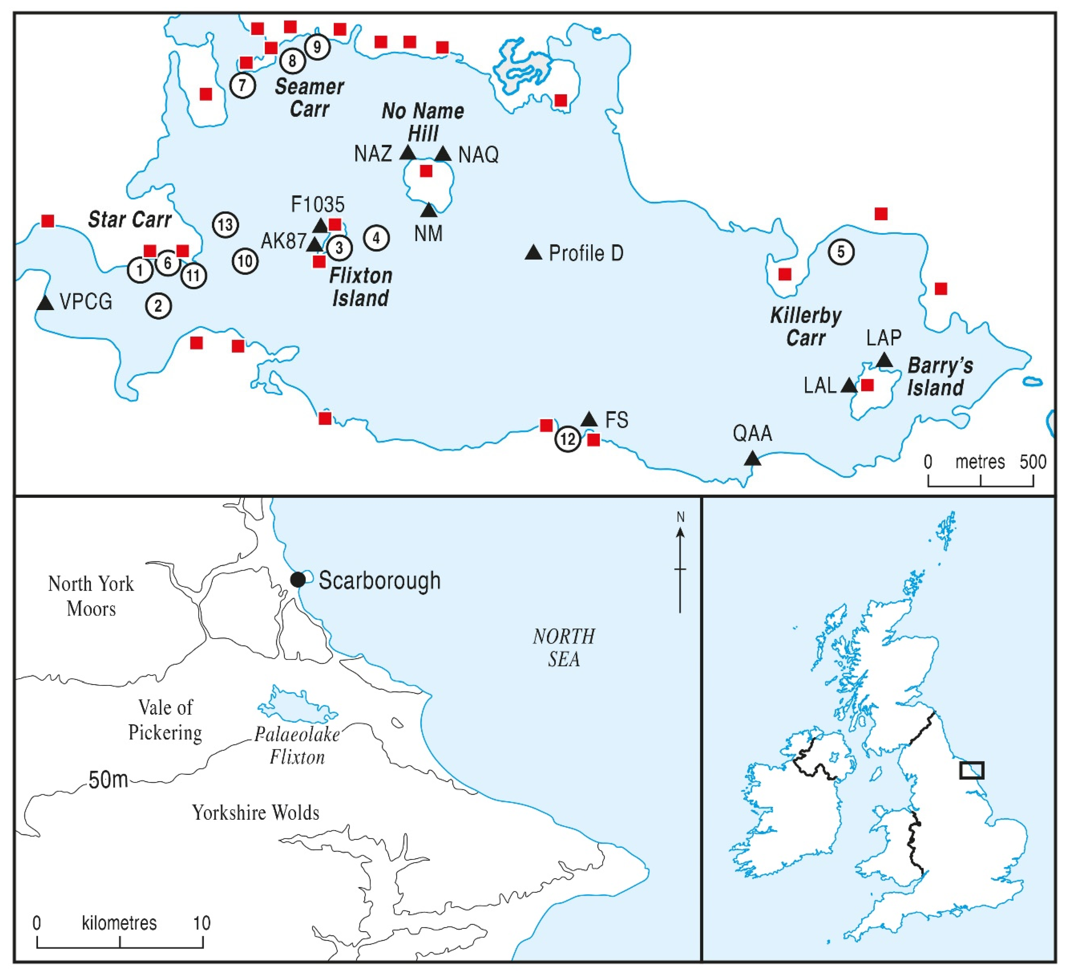
2. Study Area and Sites

The Vale of Pickering is a flat-bottomed valley which lies between the uplands of the North York Moors and the Yorkshire Wolds (Figure 1). The Vale was mostly unglaciated during the last glacial (Devensian) period [36], although ice from the North Sea did penetrate the eastern end [37] and left glaciofluvial sands and gravels which form the Wykham Moraine and the area to the east of it [36,38,39]. This margin of the North Sea ice impounded a glacial lake, Lake Pickering, which filled the Vale. The ice also scoured a depression to the east of the moraine where the bedrock surface was already very low [40]. Upon deglaciation [41], this eastern depression accumulated meltwater and became a large lake, termed Lake Flixton, which drained westward to the Vale of York, being separated from the nearby North Sea by morainic ridges. It was much the largest of several lakes which formed in basins to the east of the Wykeham Moraine [42,43,44,45]. This eastern part of the Vale of Pickering contains abundant sand and gravel deposits laid down during deglaciation, and the bed of Lake Flixton had a very complex topography, so that the lake comprised several small basins with deeper water, with mounds of glacigenic deposits forming islands in the lake [46]. During the Lateglacial and the early Holocene, the lake became infilled by sediment, first by marls and clays in the Lateglacial and then by alluvium and organic lake muds (gyttjas) and peats in the Holocene [46,47]. By the mid-Holocene, the lake was almost completely terrestrialised, and the area became covered by late Holocene peat, concealing the area of the palaeolake and its topography. The geomorphology and depositional history of the lake basin during the Lateglacial and early to mid-Holocene have been described in a number of recent publications [1,28,46,48]. Increasingly intensive land drainage for agriculture in recent decades has caused major peat dewatering and shrinkage [49,50], exposing the former lake islands as low hills of glacigenic sands and clays protruding from the reduced peat cover. Three large former islands have become exposed and these have become designated as Flixton Island, No Name Hill and Barry’s Island (Figure 1). These and other smaller islands, and also the lateral extent and sub-surface contours of the former lake basin generally, became established by a hand-auger survey of the peat [21], particularly in the western part near Star Carr, Seamer Carr and Flixton Carr. At its greatest extent, the palaeolake was about 4 km long and over a kilometre broad.
As most of the previous palaeoenvironmental research was concentrated in the north-western part of the palaeolake because of the earlier archaeological excavations around Star Carr and Seamer Carr [4], the new profiles presented in this paper (Table 1 and Figure 1) were selected to extend coverage to the remaining parts of the lake basin, where more recent archaeological excavations have taken place, to allow spatial reconstruction of vegetation development around the whole lake, including on the three recently discovered palaeo-islands. The sites were selected to be close to or at the site of archaeological excavations of early Mesolithic sites which contained major flint, bone and wooden remains, evidence of early Holocene human settlement or activity. Two profiles have been completed at Flixton Island (AK87 and F1035), three profiles at No Name Hill (NAZ, NAQ and NM), and two at Barry’s Island (LAL and LAP). Three profiles are sited at the palaeolake edge in areas not previously studied (FS, QAA and VPCG), and a deep profile (D) is situated in the centre of the lake basin to provide a more regional woodland history, with which the other pollen diagrams can be compared, away from the lake margins and wetland where many settlement sites were concentrated [6,9] and where domestic activities and other human impacts might well have affected local woodland communities.

3. Materials and Methods

3.1. Sampling

Sediments were recovered using a Russian-type corer or in aluminium alloy monolith tins as part of adjacent archaeological excavations. Stratigraphic descriptions of the sediment profiles are given in a Supplementary file (Table S1).

3.2. Pollen and Microcharcoal Analysis

Laboratory preparations and pollen identification followed standard procedures, using KOH, HCL, HF where necessary, and acetolysis [54]. Exotic marker grains of Lycopodium clavatum were introduced in tablet form [55] to allow the calculation of pollen and microcharcoal concentrations, expressed as number per unit volume of wet sediment, which were used to determine the sampling intervals and are used to inform the interpretation where appropriate. Sampling intervals ranged between 1 and 4 cm, with most diagrams counted at 2 cm intervals. Pollen residues were mounted in silicone oil and pollen counted at ×400 magnification. Pollen frequencies are expressed as percentages of total land pollen, and only selected taxa are shown. Corylus-type includes Myrica [56], but as very few grains of Myrica type were encountered, it is henceforward referred to as Corylus in the text. Pollen diagrams have been constructed using TGView software [57,58], with frequencies expressed as percentage of total land pollen (TLP). Stratigraphic symbols on the pollen diagram lithology columns follow Troels-Smith [59]. In some diagrams, Cyperaceae is excluded from the total land pollen calculating sum, because of its local superabundance. Total land pollen counts always exceeded 500 grains. Zonation of the pollen diagrams is based on major changes in the tree and shrub curves. Microscopic charcoal particles (those which passed through the 180 µm sieve used in laboratory preparation) were counted upon the pollen slides relative to the standard pollen count, providing a pollen/charcoal ratio. The tops of the pollen diagrams were determined by the point at which the peat became too dry and oxidised to preserve viable pollen, often at over two metres depth because of the dewatering of the peat following modern drainage, a problem examined at Star Carr [49,50,51] but a process occurring throughout the Lake Flixton area and rapidly degrading its archaeological and palaeoenvironmental resource.

3.3. Radiocarbon Dating

Radiocarbon dating for these profiles was carried out at Hanover and Beta-Analytic Miami, with one date from Oxford, and Table 2 gives age-range and mean age calibrations and other details of the radiocarbon dates that are mentioned in the text and shown on the diagrams. Dates have been calibrated using OxCal 4.2 and IntCal13 [60]. Some of the dates have large standard deviations and therefore wide calibration ranges, which must be taken into account in their interpretation. The calcareous nature of most of the local geology and therefore of the lake sediment means that hard water influence on results must be considered, and at some sites radiocarbon dates in the lower profile do seem to be too old and are disregarded although still shown on the diagrams and tables.

4. Results

The new pollen diagrams are presented and they are zoned using the relative proportions of the major tree and shrub taxa which would have comprised the extra-local dryland woodland but their vegetation history is interpreted using all pollen and spore taxa. The Lake Centre core (Profile D) is presented and interpreted first, followed by the diagrams from the western half of Lake Pickering, both lake-edge and by two lake islands, and then the results from the less well studied eastern half of the palaeolake, again on both lake-edge and lake island cores. Although not all diagrams cover the whole of the Lateglacial to mid-Holocene period, there is considerable chronological overlap between sites and correlation of the pollen data allows a conspectus reconstruction of site-wide woodland history. Each diagram has a code, shown in parenthesis in the following descriptions, which is used to identify it in the rest of the paper.

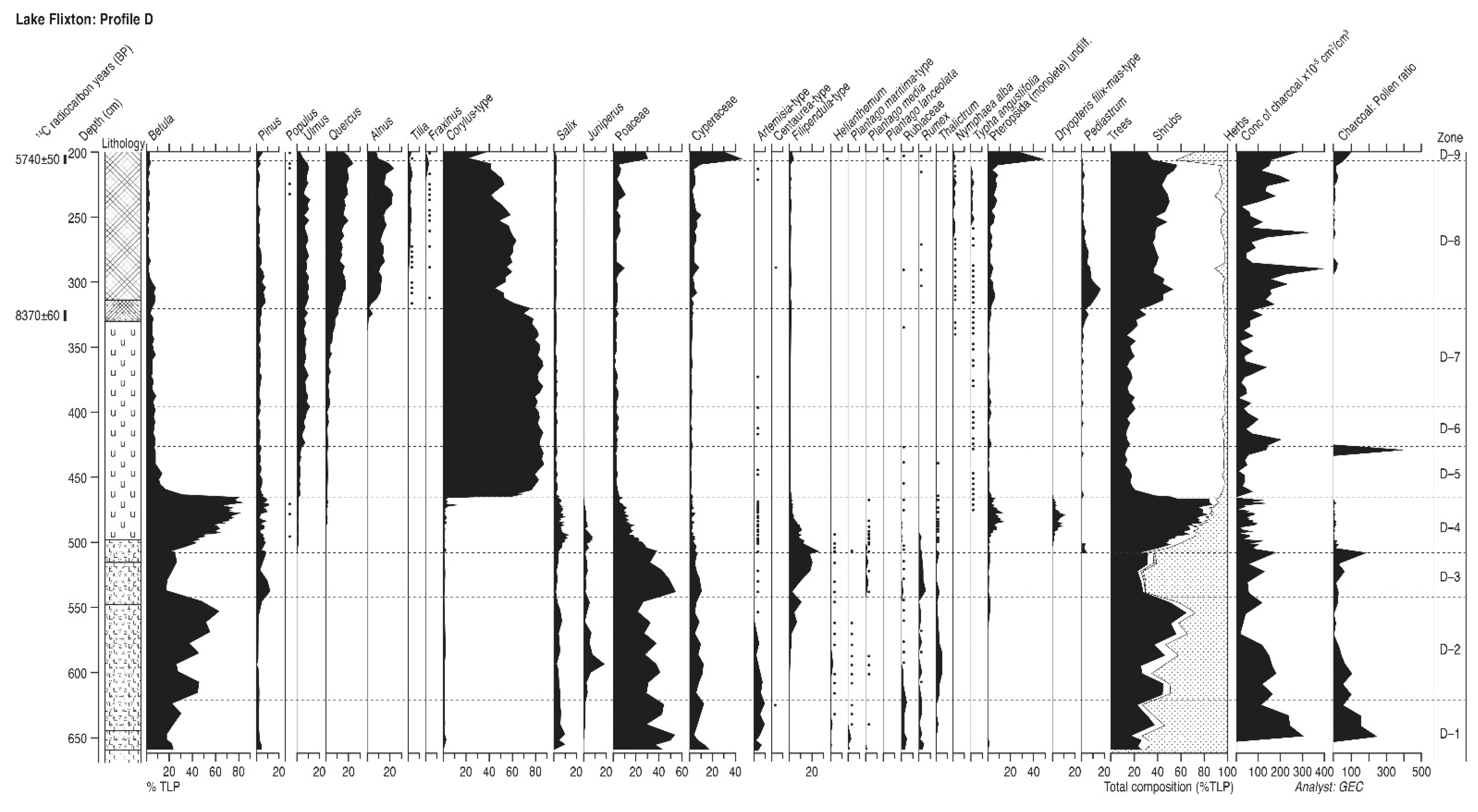
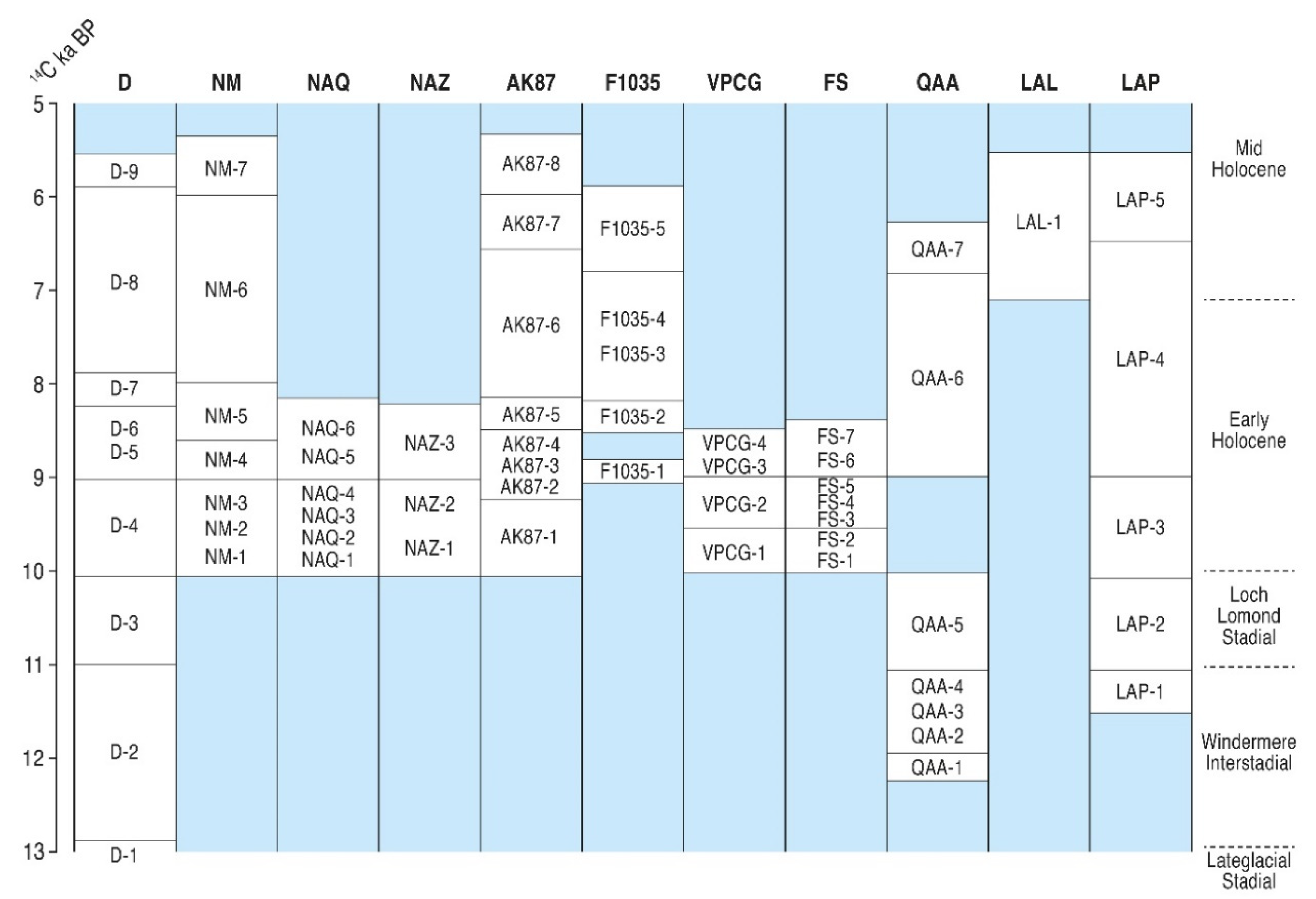
4.1. Lake Flixton Centre (Profile D)

This deep core (6.7 m, Supplementary Table S1) was taken with a Russian corer from the centre of palaeolake Flixton (Figure 1), where the deepest sediments were located, well to the east of Flixton Island and No-Name Hill. It was positioned as far away from the palaeolake edge and from all archaeological sites as possible, in order to provide a record from a more regional pollen source area [61]. It is designed to supplement the core of Day [28], which is of a similar depth but is not very far from both Star Carr and Flixton Island, and so might contain contributions of pollen from woodland affected by more local, site-related human activities. Also, the top of Day’s diagram was dated to 6515 ± 95 14C BP and it was hoped that later sediment might be recovered from this new lake centre core, which proved to be the case, the new record extending to 5740 ± 50 14C BP. Profile D is designed to provide a template of vegetation history with which the other new diagrams, as well as the previously existing pollen data, can be compared and correlated. It also provides another long vegetation history (Figure 2) that can be compared with pollen diagrams from the wider Northeast Yorkshire region. Two radiocarbon dates are available from the upper part of profile D (Table 2).

4.1.1. Pollen Assemblage Zones

The following nine pollen assemblage zones are recognised, subdivided into sub-zones on the diagram to aid interpretation.
D1
660–620 cm Betula-Salix
D2
620–564 cm Betula-Juniperus-Salix
D3
564–542 cm Betula-Salix-Juniperus
D4
542–500 cm Betula-Pinus-Salix-Juniperus
D5
500–465 cm Betula-Pinus-Salix-Juniperus-Ulmus
D6
465–425 cm Corylus-Betula
D7
425–319 cm Corylus-Ulmus-Quercus-Betula
D8
319–206 cm Corylus-Ulmus-Quercus-Alnus
D9
206–200 cm Quercus-Corylus-Alnus

4.1.2. Interpretation

Because of the calcareous nature of the sediment, particularly in the lower profile, and the lack of terrestrial macrofossils within it, only two radiocarbon dates were applied to this core, from the upper sediments, to avoid hard water error problems. This mirrors the findings of Day [28] whose radiocarbon ages on sediment with Lateglacial pollen assemblages were clearly too old and so disregarded. The chronology of the lower core must be inferred from previous radiocarbon-dated studies from the Vale and the wider region [45,62,63,64]. Sedimentation began in the Lateglacial period, shown by fluctuations the Betula and Poaceae curves and the absence of other tree taxa in zones D1 to D3. Major frequencies of cold-tolerant steppe-tundra herbs Artemisia, Rumex, Rubiaceae and Plantago maritima, and also the higher Poaceae values, indicate that zone D-1 is likely to represent the very cold pre-Interstadial conditions of the early Lateglacial. The zone D-1 to D-2 boundary therefore could form the start of the Lateglacial Interstadial and a major rise in temperature, dated in the Greenland ice-core data [65] to about 13,000 14C BP, a date confirmed by radiocarbon dating in the East Yorkshire region at The Bog, Roos [62] and at Seamer Carrs [66]. Zone D-2 must represent the temperate climate Lateglacial (Windermere) Interstadial [64,67,68] with high Betula, Salix and Juniperus values, and the high Betula frequencies towards the end of zone D-2 is a feature of the Interstadial’s later stages and climatic maximum in regional Lateglacial pollen diagrams [69]. There is a level just above 600 cm depth where Betula frequencies decline sharply, with peaks of herb and shrub pollen, notably Thalictrum, Helianthemum and Juniperus, in what must be a brief period of colder conditions. This colder phase will equate with GRIP climate phase GI-1d (Older Dryas), which occurred about 12,000 14C BP [63] and has been recognised on several other North and East Yorkshire pollen diagrams of this age [69,70], as in the Vale of Pickering at Star Carr [28]. Betula frequencies were higher in the lower part of zone D-2, the early Interstadial, although declining curves for Artemisia and Helianthemum suggest only moderate temperatures and persisting open vegetation as conditions ameliorated slowly, similar to the record from Routh Quarry in nearby Holderness [71]. Zone D3 will represent the colder conditions of the Lateglacial Stadial between about 10,800 and 10,000 14C BP, as Betula and other woody taxa are in low values and open ground herbs Poaceae and Rumex show peak frequencies, and Filipendula rises late in the zone as climate began to ameliorate. The zone D3/D4 boundary is the base of the Holocene at c. 10,000 14C BP, where the rapid rise of Betula frequencies to abundance in zone D4, together with peaks in shrubs Juniperus and Salix, indicates succession towards the establishment of early postglacial closed birch woodland. The D4/D5 boundary represents the rational limit of Corylus, which replaced Betula in the centuries around 9000 14C BP [1], and rose to complete dominance of the assemblage in zone D-5. The deciduous woodland was more diversified in zones D-6 and D-7, when Ulmus and then Quercus became established in the forest in low frequencies. Although remaining the most abundant pollen taxon, Corylus frequencies fall sharply in zone D-8, as Quercus increased and Alnus joined the woodland community, both consistently providing about 20% of the total pollen sum, with Tilia increasing late in the zone as the assembly of the mid-Holocene mixed forest was completed. The uppermost zone D-9 records the disturbance of this stable forest community, with Quercus, Alnus and Corylus values all falling sharply, Poaceae and Cyperaceae greatly increased and some weeds, including Plantago lanceolata, appearing. Hydrological changes in the wetlands around the lake might explain the great rise in grass and sedge pollen, thus depressing the tree percentages, although some land disturbance around the lake edges seems likely. In summary, the lake centre profile D therefore contains a continuous pollen record from the early Lateglacial before 13,000 14C BP to the mid-Holocene at 5740 ± 50 14C BP, and provides a regional pollen diagram for the Lake Flixton area with which Day’s long diagram [28], recent lake centre studies [26,27] and other local pollen stratigraphies can be correlated.

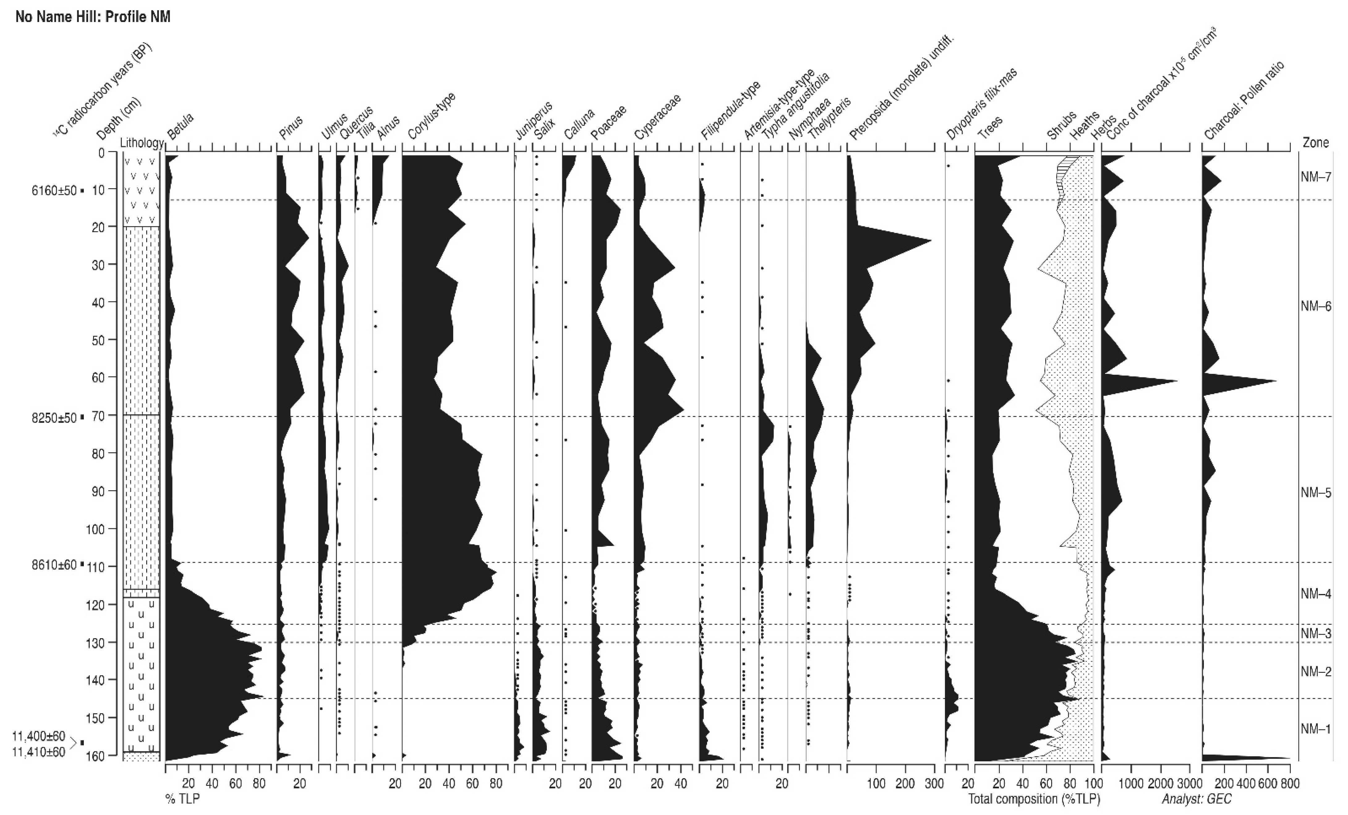
4.2. No-Name Hill (Profile NM)

No-Name Hill is a steep-sided mound of glacial material, in the northern-central area of the lake Flixton basin, which formed the largest island within the palaeolake (Figure 1) until buried by terrestrialisation and peat growth in the mid- and later Holocene. It was revealed by peat shrinkage due to drainage and by auger survey. It was first recognised by Moore [72] in his early investigations of the area and contains excavated early Mesolithic flint sites [6]. Profile NM is located off the southern edge of the island in deep peat, and sediments were retrieved from an archaeological trench using monolith tins. The stratigraphy is described in Supplementary Table S1 and illustrated in Supplementary Figure S1 and comprises woody detrital peat overlying reed peat above marl which rests upon gravel-rich fine sand and then a basal clay. It is typical of the early to mid-Holocene succession the Vale. Sub-samples were taken for pollen analysis at one cm intervals in the early Holocene and four cm intervals in the mid-Holocene. Five samples were submitted for radiocarbon dating and the results are shown in Table 2 and Figure 3.

4.2.1. Pollen Assemblage Zones

The following seven pollen assemblage zones are recognised, subdivided into sub-zones on the diagram to aid interpretation.
NM-1
162–144 cm Betula-Salix-Juniperus
NM-2
144–129 cm Betula-Salix
NM-3
129–125 cm Betula-Corylus-Salix
NM-4
125–109 cm Corylus-Betula
NM-5
109–70 cm Corylus-Pinus-Ulmus
NM-6
70–13 cm Corylus-Pinus-Ulmus-Quercus
NM-7
13–0 cm Corylus-Alnus-Pinus-Ulmus-Quercus

4.2.2. Interpretation

As with other sites in this study, the radiocarbon date at the base of the profile appears to have been badly affected by hard water error, the calcareous nature of the lake water at this location being shown by the accumulation of a thick marl unit as the basal lake sediment. The pollen assemblage of the lowermost zone NM-1 shows a very early Holocene vegetation community, with Filipendula and Poaceae responding to increased warmth at the end of the Lateglacial Stadial, Juniperus and Salix bushes established as a rise in Betula frequencies progresses in a succession towards birch woodland. This phase at The Bog, Roos [62] on non-calcareous substrate in east Yorkshire is dated to 10,120 ± 180 14C BP indicating a hard water error of well over a thousand years at NM, as noted elsewhere in palaeolake Flixton [28]. A typical early Holocene vegetation succession ensues, with Juniperus shaded out by the closure of the Betula canopy, as were herbaceous taxa, and Salix likely surviving in wet areas around the lake edge. In turn, the introduction and expansion to very high values of Corylus occurred as the Holocene progressed, replacing Betula as the dominant woodland component and suppressing Salix, and the radiocarbon date of 8610 ± 60 14C BP after the maximum of the hazel curve suggests that hard water error is no longer operating, as it is in accord with an interpolated date of about 9000 BP for the Corylus rise, which occurred in the marl unit and so was not dated directly. That date of 8610 ± 60 BP marks the expansion of Ulmus and Pinus as these trees immigrated and the woodland diversified. At 8250 ± 50 14C BP Quercus joined the assemblage and Pinus increased as Corylus frequencies fall, although hazel remains the largest contributor. The final stage in the assembly of the mid-Holocene woodland occurred when Alnus is introduced to the assemblage, although not in very high values. The date for this event of 6160 ± 50 14C BP seems very late compared to the usual dates in the region of just before 7000 14C BP, but the range of dates for the Alnus-rise is considerable and a similarly late date occurs at core Flixton AK-87, below, another lake island core. Alder may have found it difficult to become established in already densely wooded island vegetation without the opportunity provided by disturbance. Microcharcoal levels are low in the earlier part of the profile, but increase from the top of zone NM-4. Peaks in microcharcoal in NM-6 and 7 coincide with fluctuations in Corylus suggesting some woodland disturbance, possibly coinciding with human activity in the local area. In general, the early to mid-Holocene vegetation history at NM is similar to that at profile D, which is not far away in the lake centre.

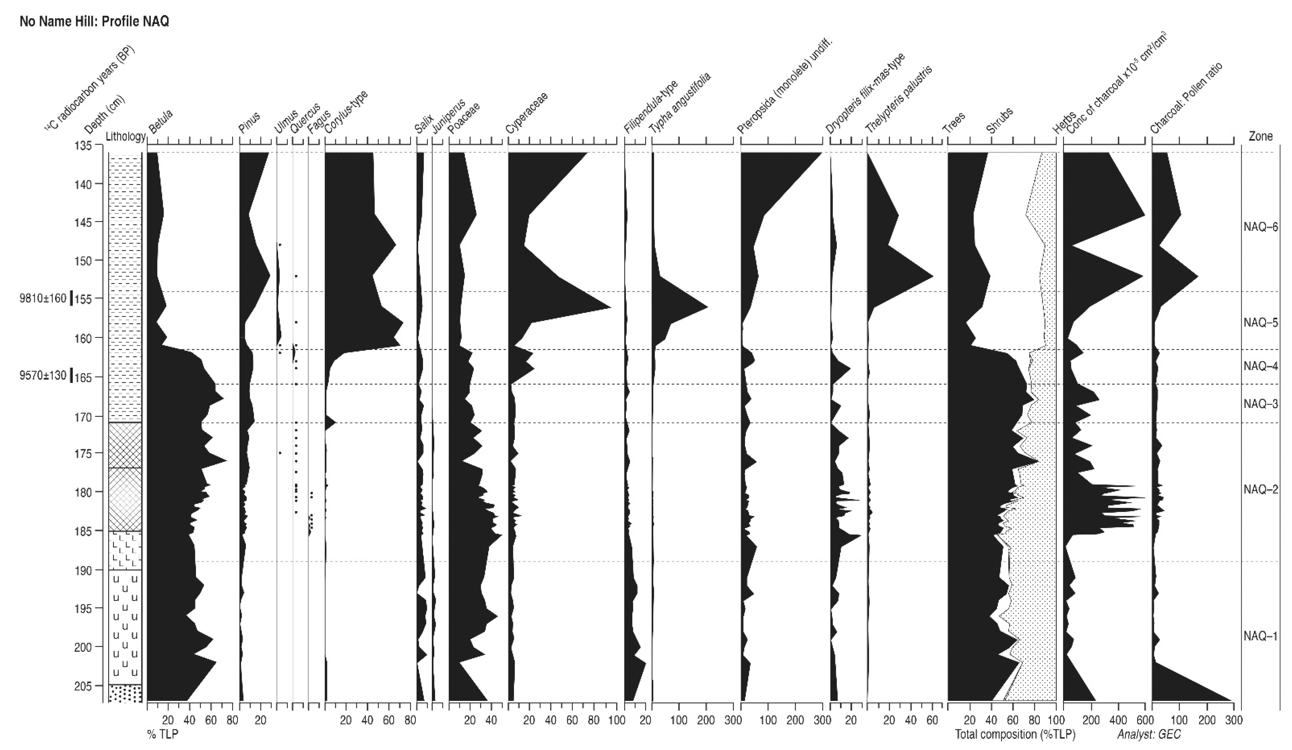
4.3. No-Name Hill (Profile NAQ)

The core termed profile NAQ lies at the north-east corner of lake-island No-Name Hill (Figure 1), a few metres into the palaeolake from the island’s edge, so that a deep core could be recovered. The sediments were sampled using monolith tins in the side of an archaeological trench. The top 1.5 metres of sediment were oxidised and are not included in the analysis. It should record conditions on the northern margin of the palaeolake as well as on the island itself. It complements the record from profile NM off the southern edge of the island which is closer to the lake centre. The stratigraphy is described in Supplementary Table S1. Sub-samples for pollen were taken every one to four cm depending on the lithology. Two samples were submitted for radiocarbon dating and the results are shown in Table 2 and in Figure 4.

4.3.1. Pollen Assemblage Zones

The following six pollen assemblage zones are recognised.
NAQ-1
207–189 cm Betula-Salix-Juniperus
NAQ-2
189–171 cm Betula-Pinus-Salix-Juniperus
NAQ-3
171–166 cm Betula-Pinus-Salix
NAQ-4
166–162 cm Betula-Pinus-Corylus
NAQ-5
162–154 cm Corylus-Betula-Pinus
NAQ-6
154–136 cm Corylus-Pinus-Betula

4.3.2. Interpretation

Of the two dates on this profile, the one of 9570 ± 130 14C BP is well below the rise in Corylus, usually dated to about 9200 BP and starting at 9385 ± 115 14C BP at Star Carr [1], and so is therefore probably accurate. The date above it, out of sequence, is too old and should be disregarded. No dates were obtained for the lower profile because of the likelihood of hard water error in the calcareous sediment. The presence of Filipendula, Salix and Juniperus in zone NAQ-1, together with a substantial Betula curve, suggests a time for sediment initiation not long after the transition from the Lateglacial Stadial to the earliest Holocene, as climate ameliorated and a succession to woodland through tall herb and shrub communities began. Weeds of open ground are absent and so sediment accumulation probably began rather later here than at profile NM on the southern edge of the island, with the substantial Poaceae curve perhaps reflecting wetland vegetation at the lake margin rather than terrestrial grassland. The small size of most of the Poaceae grains (mostly < 26 μm) suggests they derive from Pediastrum growing in local reedswamp. The consistent presence of Dryopteris, a woodland understorey plant, suggests that early Holocene birch woodland was present from the start of sediment accumulation. That Juniperus becomes sporadic after the end of zone NAQ-1 and fades from the record at the end of zone NAQ-2 reflects the increasing density of the Betula canopy. The typical early Holocene tree succession ensues, with Corylus quite suddenly replacing Betula at the start of zone NAQ-5, Pinus increasing and Ulmus entering the woodland in low frequencies. Quercus pollen is hardly present at the top of the diagram, which stopped at that level as the overlying peat was highly oxidised and preserved pollen badly, and so mid-Holocene assemblages are not represented. This accords with the record from profile NM, where Quercus is also hardly recorded, and is always a very minor element of the pollen flora. Microcharcoal peaks are generally lower than the general background levels, with several exceptions. First, is the large increase in charcoal concentration in the middle of NAQ-2 (185–177 cm), which is made up of numerous small peaks, and reflects prolonged (though not continuous) burning. This coincides with reductions in Betula, and increases in Poaceae and Pteropsida values and the appearance of Fagus. While it is difficult to determine whether the burning is the cause of vegetation change, the pollen does suggest the creation of openings within the woodland, that provide opportunities for the expansion of grasses and ferns and the growth of beech. Given the evidence for Mesolithic occupation on the island, and the increased levels of microcharcoal, this could be attributed to human activity. The same may be true of the series of smaller peaks throughout the remainder of zone NAQ-2 and into NAQ-3, which again coincide with fluctuations in Betula, Poaceae, and Dryopteris. Finally, there are the microcharcoal peaks in early zone NAQ-6, where Corylus temporarily declines, Pinus rises and Ulmus is present. The hazel decline is only moderate and there are no pollen indicators of open ground, so if the burning was responsible it was not a major event, or else at a distance from the core site. The rise of wetland types Cyperaceae and Typha angustifolia at this level might suggest an alternative reason for the hazel decline, linked to climate change and increased lake levels. Corylus frequencies then recover to their former higher values, until a second elevation of the microcharcoal curve again depresses them slightly, suggesting that burning in the vicinity was the driver for the reduced hazel abundance.

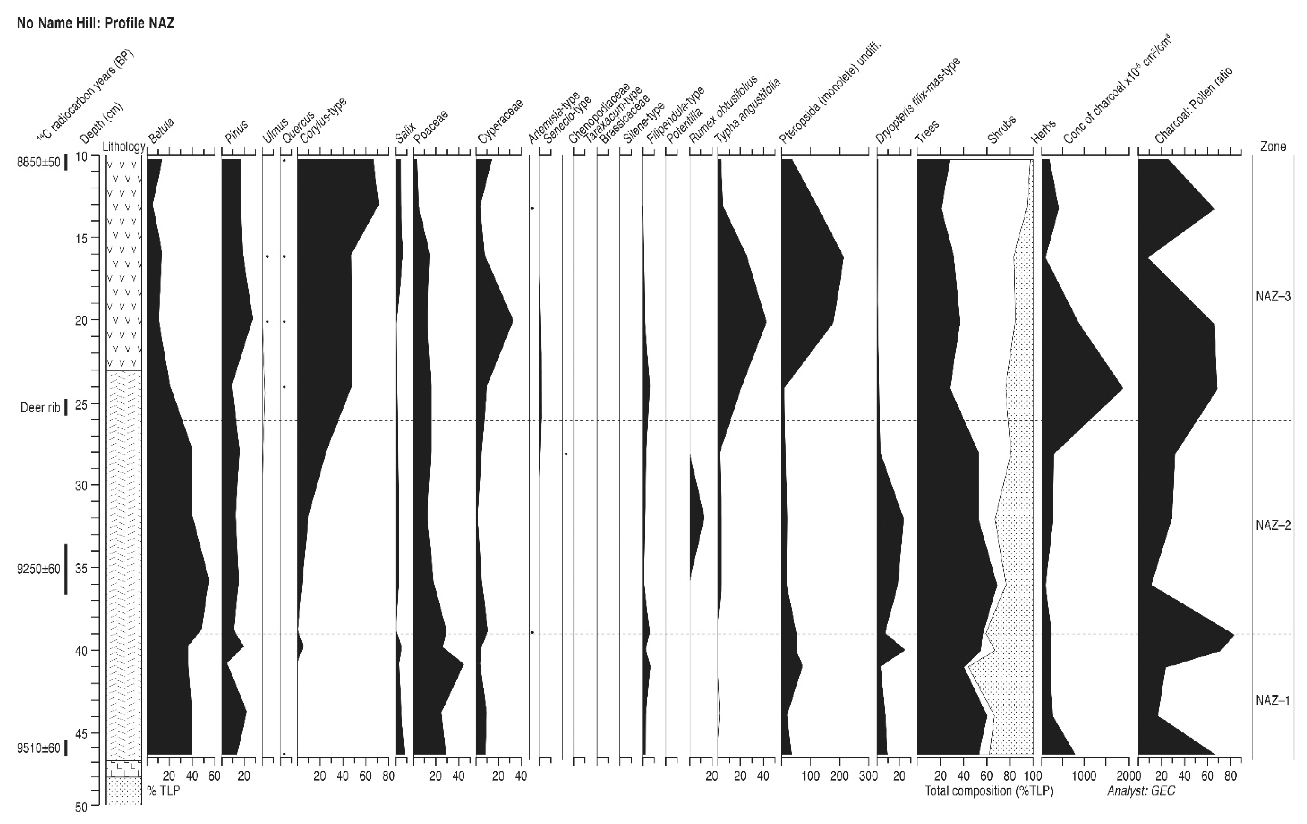
4.4. No-Name Hill (Profile NAZ)

This site, termed profile NAZ, is located in deep peat close to the edge of the north-west corner of No-Name Hill, where dense concentrations of lithic and faunal remains were found. It should record events on the island as well as conditions on the nearby northern lake edge, and should enable correlation and dating of some of the vegetation changes at profile NAQ. A single monolith tin, which included the level of a red deer bone stratified in the profile, was used to recover the sediments from an archaeological trench which contained several artifacts. The sediment stratigraphy is described in Supplementary Table S1, and comprised reed peat with abundant Corylus remains overlying lake muds with Betula wood which rested upon a thin clay layer above sand. Sub-samples for pollen were taken every one to four cm depending on the lithology. Three samples were submitted for radiocarbon dating and the results are shown in Table 2 and in Figure 5.

4.4.1. Pollen Assemblage Zones

The following three pollen assemblage zones are recognised.
NAZ-1
47–39 cm Betula-Pinus-Salix
NAZ-2
39–26 cm Betula-Pinus-Corylus
NAZ-3
26–10 cm Corylus-Pinus-Betula

4.4.2. Interpretation

This shallow profile is similar to the other No-Name Hill cores in containing a pollen record from the early Holocene until after the Corylus-rise, although once again the record terminates before the arrival of Ulmus and Quercus in the local forest, only sporadic grains being recorded. The first two dates were taken on a hazel nut and on birch wood so hard water error should not be a problem, and the date for the top of the diagram, at 8850 ± 50 14C BP, is acceptable, predating the date for the main rises of elm and oak in the eastern Vale. The date of 9250 ± 60 14C BP for the start of the Corylus rise also appears to be accurate and is almost identical to the dates on the same event from Flixton AK87 (below and Table 2) and Star Carr [1,18]. The lowest date, of 9510 ± 50 14C BP, was obtained on a piece of worked, red deer antler, and may have been contaminated by humic acids. As such, it is not regarded as an accurate estimate for the base of the profile. The Betula and Salix frequencies of the lowest zone of the diagram, with a consistent Filipendula curve, indicate warming climate after the end of the Lateglacial Stadial, although a lack of Juniperus suggests there was some delay after the start of the postglacial before organic sediment inception began. The steady Pinus curve suggests background pollen transport. Zone NAZ-2 records the arrival of Corylus and the expansion of its populations within the Betula woodland until it replaced birch as woodland dominant in a typical early Holocene succession, with Pinus increasing locally. A peak of Rumex in mid-profile suggests some disturbance, and the microcharcoal curve does show three large peaks, interestingly coincident with three phases of increased Corylus values, at its arrival, its rise to high values and a final expansion near the top of the diagram. Burning does seem to have given hazel opportunities to increase its representation at this site. Although the NAZ diagram is similar in age to those from the NM and NAQ profiles, it covers a shorter time period than the other two profiles from No-Name Hill.

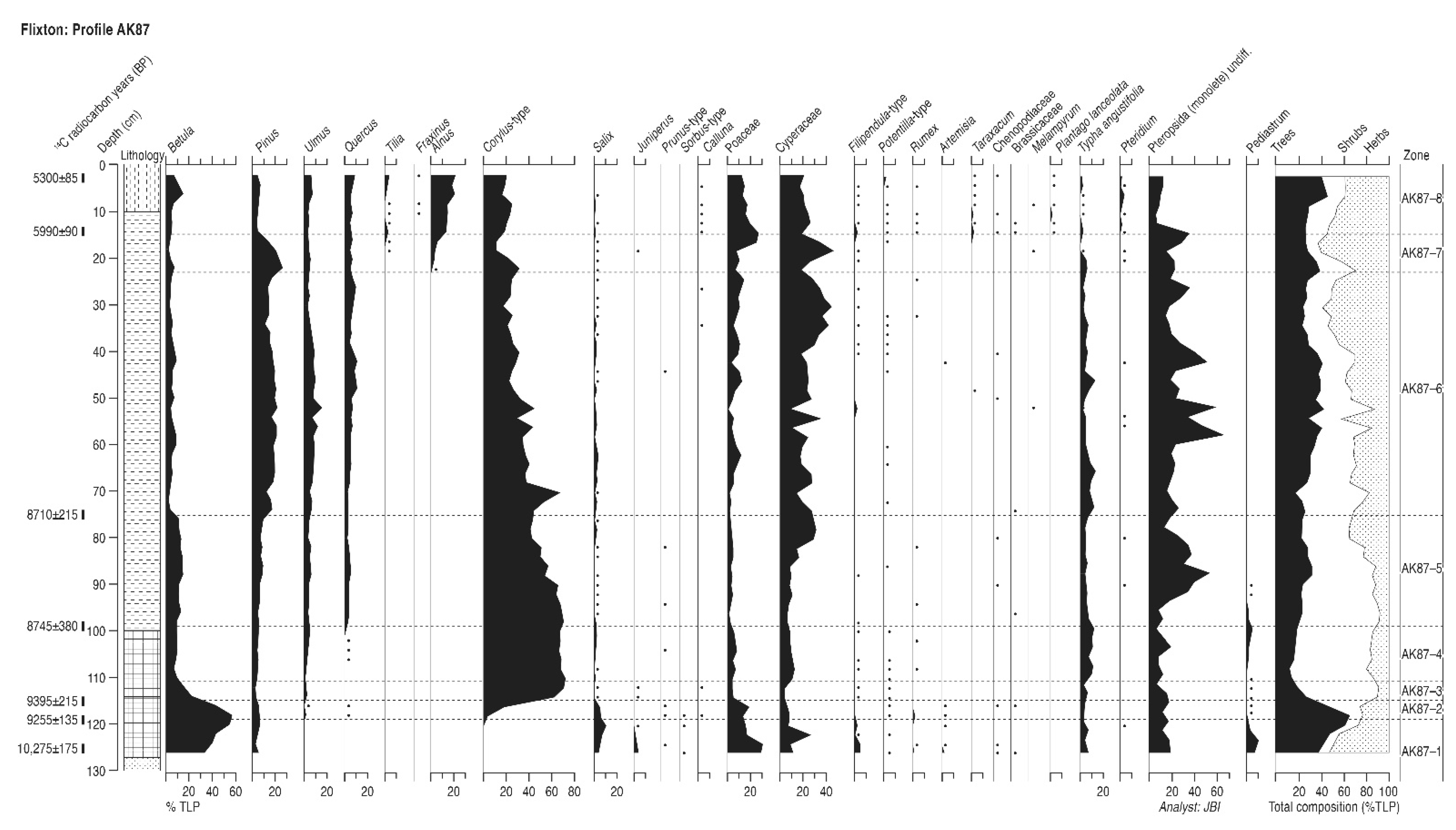
4.5. Flixton Island (Profile AK87)

This profile, termed AK87, lies in an area of deeper peat off the western edge of Flixton Island (Figure 1), another mound of glacial gravel and sand which forms an area of high ground in the middle of the palaeolake, and which would have been an island protruding from the water and the later wetland swamp and fen sediments until overwhelmed by them in the mid-Holocene. It is adjacent to an early Mesolithic flint site which lay on the edge of the former island, which has many prolific Mesolithic sites [73]. More than a metre of organic sediment was retrieved and the profile’s lithology is described in Supplementary Table S1, and comprised reed peat overlying lake mud and sand. Seven samples were submitted for radiocarbon dating and the results are shown in Table 2 and in Figure 6.

4.5.1. Pollen Assemblage Zones

The following nine pollen assemblage zones are recognised.
AK87-1
126–119 cm Betula-Salix-Juniperus
AK87-2
119–115 cm Betula-Corylus-Salix
AK87-3
115–111 cm Betula-Corylus
AK87-4
111–99 cm Corylus-Betula-Pinus-Ulmus
AK87-5
99–75 cm Corylus-Betula-Pinus-Ulmus-Quercus
AK87-6
75–23 cm Pinus-Corylus-Ulmus-Quercus
AK87-7
23–15 cm Pinus-Corylus-Ulmus-Quercus-Alnus
AK87-8
15–2 cm Alnus-Corylus-Ulmus-Quercus-Tilia

4.5.2. Interpretation

This profile records vegetation changes over the first half of the Holocene, a period of about five thousand radiocarbon years, in particular the establishment of the postglacial mixed forest trees and wetland plant successions through aquatic, reedswamp and fen environments. The assemblage of zone AK87-1, after 10,275 ± 175 14C BP, contains elements of the Late Devensian/Holocene transition from open ground herbaceous and low shrub communities to denser shrub and woodland cover. The decline in Juniperus, Thalictrum, Filipendula, Rumex and Ranunculus and the increase in Salix and Betula is typical of this transition, although the already very high birch frequencies suggest that this succession was well advanced when peat formation began. The limnic gyttja sediment and the presence of high aquatic pollen and spore records shows the site to have been within an open water phase during this period. The demise of Juniperus and open ground weeds through dense shading effects of birch and willow woods was followed rapidly in zone AK87-2, around 9300 14C BP, by the establishment and spread of Corylus, which soon replaced willow and achieved co-dominance with birch during zone AK87-3. This zone also saw the immigration and establishment of Ulmus populations and the first development of mature mixed deciduous woodland with birch, hazel and elm. In zone AK87-4, Quercus becomes a minor forest component, but Pinus and Ulmus populations increase, apparently at the expense of Betula with Corylus being largely unaffected. Aquatic pollen and spores are still common so open water still existed at the site but the increase in grass and sedge pollen suggests the proximity of reedswamp and fen environments, and more detrital herbaceous material and reed rhizomes in the sediment suggests shallowing of the water body. The end of this zone at around 8745 ± 380 14C BP sees Quercus take its place as a significant but still lesser member of the mixed deciduous forest. Sedges and other fen wetland herbs expand and aquatic indicators gradually decline as reedswamp and fen communities colonised the site during this phase. There are very few heliophyte shrub or herb taxa to indicate open conditions, so the forest at this stage must have been closed and dense. Some slight indications of open ground do recur throughout the profile, however, so some low stature communities must have persisted, probably around the wetland edge. Most herbaceous records in this central part of the profile are of marshland herb taxa. The major change in forest composition occurs at the end of zone AK87-5 when Pinus replaces Betula, presumably directly as the other tree curves are almost unaffected. The date of 8710 ± 215 14C BP is not distinguishable from the previous date, particularly with such big standard deviations, and must be considered unreliable. A long period of forest stability ensued in zone AK87-6 during which no significant successional changes occurred, although a trend towards the gradual replacement of hazel by oak may be visible. The domination by sedges of the wetland community continued, with other fen herbs and some aquatic types suggesting some spatial variety in the local distribution of wetland habitats. The immigration of Alnus at this profile is undated, but the date of about 6815 14C BP from profile Flixton 1035 (below) is probably acceptable. During zone AK87-7, the advance of Alnus into the forest seems to have been slow and perhaps it was restricted to favourable habitats within the wider community. In zone AK87-8 after 5990 ± 90 14C BP, however, a rapid expansion of Alnus occurred which was apparently almost completely at the expense of Pinus. Alnus must have been directly replacing pine in its preferred locations, probably on peat surfaces, as well as through paludification of sandy soils around the wetland perhaps due to climatic change as well as the establishment of carr around the wetland edge. It is possible that some disturbance of soils, perhaps anthropogenic, assisted alder expansion as ruderal taxa increase at the start of the high alder phase and are maintained. Calluna, Pteridium, Plantago lanceolata, Rumex, Melampyrum, Chenopodiaceae, Cruciferae and Taraxacum-type are all prominent. Tilia and Fraxinus may also have been encouraged by any such disturbance of the forest, as well as natural successional immigration. The date of 5990 ± 90 14C BP seems rather late for the Alnus rise, but this feature seems to be time transgressive in this area, with local factors very important. The radiocarbon date for the top of the studied profile of 5300 ± 85 14C BP fits well with this date and the pre-Ulmus decline nature of the pollen data, although it is within the older part of the range of radiocarbon dates for the Ulmus Decline in lowland northern England [74,75,76].

4.6. Flixton Island (Profile 1035)

This profile lies at the western edge of Flixton Island (Figure 1), adjacent to profile AK87. It is associated with an early Mesolithic flint site which contains a hollow in the island’s surface which is filled with sediment. A thin shallow organic mud layer lies beneath a thick sand lens above which lies a further twenty centimetres of peat. The detailed lithology is described in Supplementary Table S1. Three samples were submitted for radiocarbon dating and the results are shown in Table 2 and in Figure 7.

4.6.1. Pollen Assemblage Zones

The following five pollen assemblage zones are recognised.
F1035-1
50 cm Corylus-Betula-Pinus
F1035-2
31–25 cm Corylus-Betula-Ulmus
F1035-3
25–21 cm Corylus-Ulmus-Pinus-Quercus
F1035-4
21–17 cm Corylus-Pinus-Ulmus-Quercus-Betula
F1035-5
17–12 cm Corylus-Betula-Ulmus-Quercus-Alnus

4.6.2. Interpretation

The pollen content of the thin mud layer (F1035-1) at the base of the profile correlates with the early part of zone AK87-4 in having high Betula, Pinus and Corylus, with moderate Ulmus values and no Quercus. The radiocarbon date of 8930 ± 85 14C BP also fits very well with this position on the AK87 profile, and so the correlation of the two data sets at this point seems acceptable. Well-developed mixed deciduous forest was the dryland vegetation, with fen-reedswamp environments with reeds, sedges and bulrushes characterising the local wetland. Particle size analyses show the thick sand layer that separates zones F1035-1 and F1035-2 to be extremely well sorted and so likely to have had a wind-blown origin, perhaps caused by destabilisation and deflation of local sandy soils. After the deposition of the sand layer, the forest was composed of Betula, Corylus, Ulmus and Quercus in zone F1035-2, but site conditions seem to have been open and disturbed, with a range of ruderal weeds including Taraxacum-type, Plantago lanceolata, Silene-type, Cruciferae, Chenopodiaceae, Rumex and Cirsium-type. This community presumably reflects the human occupation of the site locality. The range of wetland herbs recorded is also very diverse and reflects the rich fen environments existing at the site at this time. This diversity is progressively reduced in the following zone F1035-3 as increasing Quercus and declining Betula suggests more mature local forest and reduced human impact nearby, as the ruderal suite is also much depleted. The pollen changes of this zone and of F1035-4 record natural successional development in both wetland and dryland vegetation. Dryland herbs are no longer recorded and increased sedges and a reduction in fen taxa suggest a less open fen environment becoming more terrestrial. There are no indications of any changes in the established forest beyond the wetland margin. The introduction and establishment of Alnus at about 6815 ± 110 14C BP at the start of zone F1035-5 may be the result of local wetland succession to carr habitats, as Betula seems to be the tree most disadvantaged by Alnus immigration. This phase, with Alnus at only about 20% of tree pollen or 10% of total pollen, correlates with the latter stages of zone AK87-7, before the major fall of Pinus and the rapid expansion of Alnus to abundance. The introduction of Tilia but not of Fraxinus supports this correlation. Alnus seems to have been established locally, perhaps restricted to carr habitats, for several centuries before ecological changes in the mid-Holocene allowed its expansion and replacement of Pinus. The large standard deviations on the dates make interpretation very difficult unfortunately.

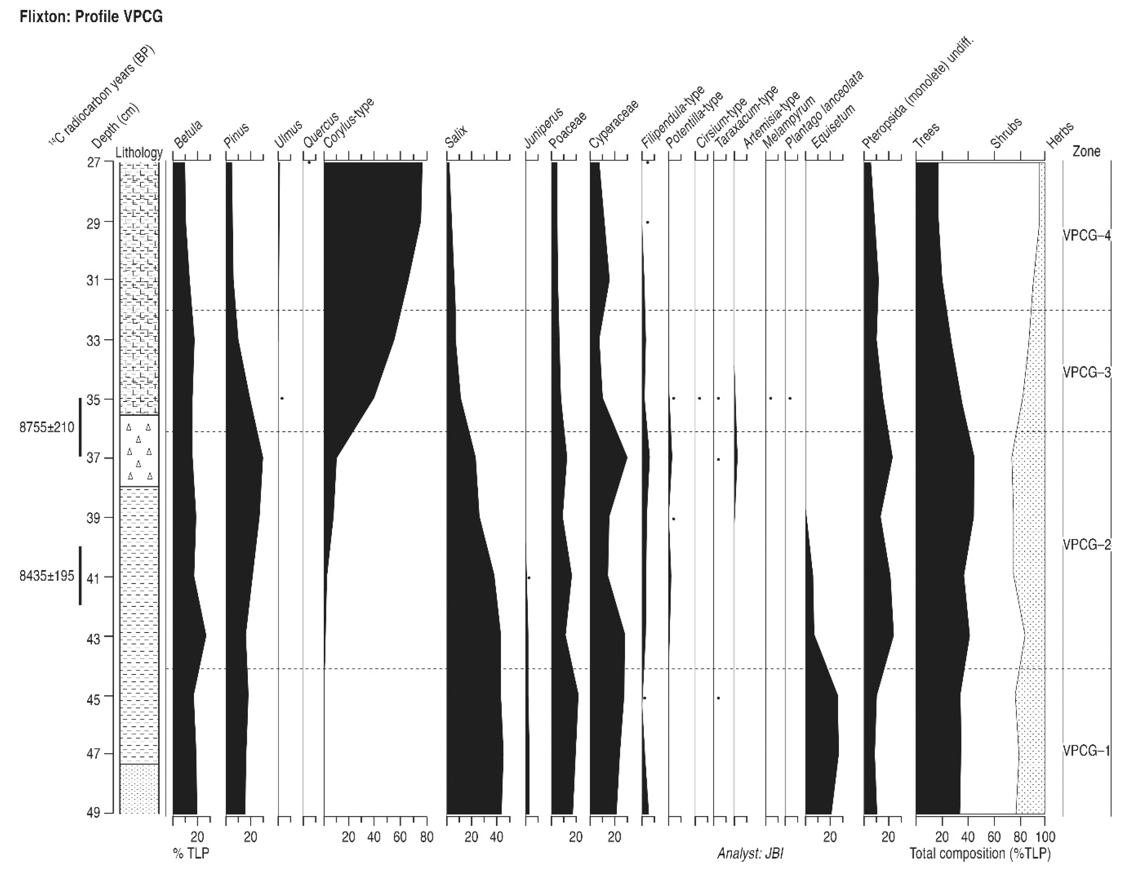
4.7. Flixton Carr (Profile VPCG)

This profile (termed VPCG) lies at the extreme western end of the palaeolake, adjacent to its early Holocene outlet and on the south side of it opposite the Star Carr archaeological site (Figure 1). Shallow well humified peat contained a thick charcoal layer in mid-profile with flints stratified in the peat below it. The detailed lithology is described in Supplementary Table S1. Two samples were submitted for radiocarbon dating and the results are shown in Table 2 and in Figure 8.

4.7.1. Pollen Assemblage Zones

The following four pollen assemblage zones are recognised.
VPCG-1
49–44 cm Salix-Betula-Pinus-Juniperus
VPCG-2
44–36 cm Salix-Pinus-Betula-Corylus
VPCG-3
36–32 cm Corylus-Betula-Pinus-Salix
VPCG-4
32–27 cm Corylus-Betula

4.7.2. Interpretation

Peat initiation at this profile took place at a time similar to that at AK87, before the immigration of Corylus and while Juniperus was still able to find habitats within an increasingly dense tree and shrub canopy. Sedimentation began under fen-reedswamp conditions with abundant local Equisetum as well as sedges and reeds. There might even be some indications of open conditions in the lowermost sample as Thalictrum, Ranunculus and Senecio-type are present and Filipendula high, although all could be members of the wetland community. In contrast to the Betula domination at AK87, if this correlation is correct the woodland around VPCG contained much more Pinus and particularly Salix. There are few aquatic types and sedimentation began under fen-reedswamp marsh conditions with abundant local Equisetum as well as sedges and reeds. This profile is again similar to AK87 in that a gradual decline in Salix populations was accompanied by a slow increase in Corylus and the demise of Juniperus. Little change seems to have taken place in the relative proportions of birch and pine which presumably formed the local dryland forest. The start of the rise of Corylus is radiocarbon dated here as about 8435 ± 195 14C BP, which seems to be much too late by comparison to the dates from AK87 which form a reasonable series. This VPCG date should probably be discarded. The shallow nature of this profile and its damage by drainage has probably led to water table fluctuations which have contaminated the peat with younger carbon. The next dated level coincides with the charcoal layer and with the expansion of Corylus to very high frequencies. The two features are probably closely related with the fire which created the charcoal disturbing the wetland edge vegetation and allowing the rapid expansion of fire-favoured hazel in its place. A slight diminution of Pinus occurred but Salix was the main casualty of this fire event and the removal of an ecotonal willow belt between the developing marsh and the Betula-Pinus woodland seems likely. The fire created areas of open ground initially, for ruderal weeds briefly expand, including Taraxacum-type, Artemisia, Melampyrum, Cirsium-type and Plantago lanceolata. Senecio-type shows a peak also, but had been present before this event. The change in forest composition might have helped the spread of other taxa, as an isolated Ulmus pollen grain was observed at this level. The date on the charcoal of 8755 ± 110 14C BP seems late in comparison to the AK87 date for the Corylus expansion, but charcoal is likely to be much more reliable as a dating medium than peat in this profile and the Corylus rise could well be time transgressive, particularly if instigated by individual site factors such as fire, whether humanly directed or not. The presence of flints in the peat below the charcoal band makes human agency here quite probable. The high standard deviation means that the difference of a few centuries between the hazel rise dates may not be significant. The upper part of the profile records a return to woodland stability with Ulmus having found a minor but established place within the Betula, Corylus and Pinus forest. Sedge fen conditions, as at AK87, continued to characterise the wetland.

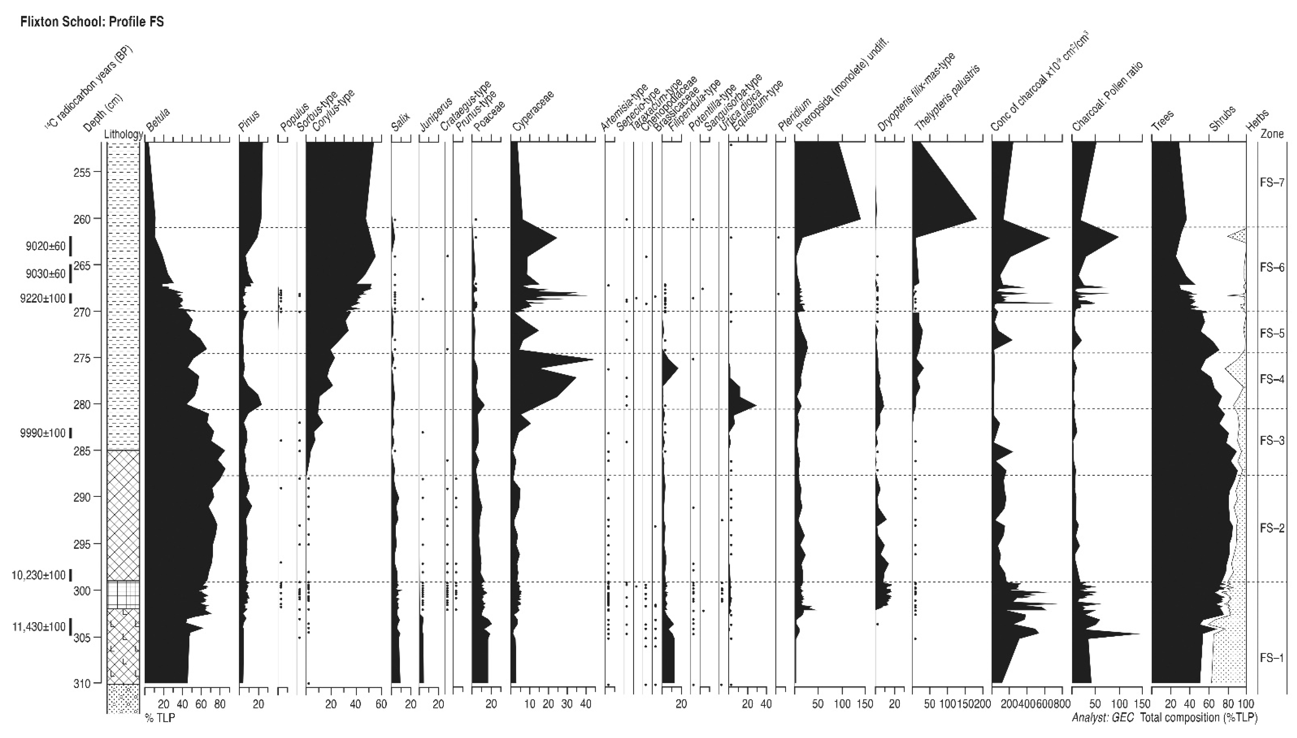
4.8. Flixton School (Profile FS)

This site is located on the edge of the southern shore of palaeolake Flixton (Figure 1), in what would have been a small inlet to the east of a promontory of land projecting into the lake. The site is located in an area of chalk substrate covered by Lateglacial coversands, is adjacent to Flixton School and so has been termed profile FS. The sediments were collected as part of the excavation of an extensive early Mesolithic flint site which covers about 1500 m2, using monolith tins from an excavation trench. The stratigraphy is shown in Supplementary Table S1. Samples for pollen analysis were taken at one or two cm intervals (Figure 9). Six samples were submitted for radiocarbon dating and the results are shown in Table 2 and in Figure 9. The core is very near to the site of a published pollen diagram which was completed at Flixton School House Farm at the site of a Bos skeleton [52] and which, although undated, clearly contained a pollen record that spanned part of the Lateglacial Interstadial, the Loch Lomond Stadial and the earlier Holocene, and with which the FS profile can be compared.

4.8.1. Pollen Assemblage Zones

The following seven pollen assemblage zones are recognised.
FS-1
310–299 cm Betula-Salix-Pinus
FS-2
299–288 cm Betula-Pinus-Salix
FS-3
288–281 cm Betula-Corylus-Pinus
FS-4
281–274 cm Betula-Pinus-Corylus-Salix
FS-5
274–270 cm Betula-Corylus
FS-6
270–261 cm Corylus-Betula-Pinus
FS-7
261–253 cm Corylus-Pinus-Betula

4.8.2. Interpretation

The pollen diagram covers the early Holocene from its beginning to after the rise in Corylus-type pollen which generally occurs a little before 9000 14C BP. The dates in the upper part of the diagram agree with this pollen stratigraphic feature and, being on reed peat, are probably valid. The dates near the base of the diagram, however, would seem to be too old, presumably because of hard water error near to the limestone substrate soils, as there is no record of Lateglacial-type pollen assemblages in the lower zones to corroborate the Lateglacial dates, which should be disregarded. Typical Loch Lomond Stadial taxa such as Artemisia are not significant. The base of the diagram might well have started accumulating soon after the transition from the Lateglacial Stadial, however, as there is silt in the lower layers of the organic lake muds, a temporary presence of isolated ruderal weed pollen grains and the Salix, Juniperus and Filipendula curves hint at plant successions in the earliest postglacial as Betula woodland became established. Poaceae is also quite high, although it might relate to nearby lake edge marshes, with Equisetum also prominent. The recording of Populus pollen is unusual, as its preservation rarely occurs, but supports the very early Holocene interpretation. This Betula woodland, with Salix and other shrubs, is typical of the earliest Holocene period, as seen at nearby School House Farm [52], elsewhere at Lake Flixton [28] and in other East Yorkshire pollen records [62]. Betula woodland is dominant until the expansion of Corylus-type in the middle of the first Holocene millennium, hazel rising to a consistent high curve at 9220 ± 100 14C BP, in accord with regional patterns. The increases in wetland marsh taxa, primarily Cyperaceae but also Filipendula and Thelypteris palustris, reflect the expansion of the lake and lake-edge communities during this phase. After about 9000 14C BP the dryland vegetation was stable Corylus-dominated woodland with significant Pinus, which either took advantage of habitats on the local limestone or had its pollen transported to the site from not too far away, given its substantial frequencies. The record cannot progress far beyond the time of the rise of Corylus-type pollen, as Quercus and Ulmus pollen is entirely absent. The diagram is interesting for the consistent presence of background microcharcoal, which rises to high peaks in the earliest Holocene (zone FS-1) and at the time of the rise of Corylus-type to high values (zone FS-6). These peaks, which also contain macroscopic charcoal at these levels, suggest local burning rather than more distant catchment fires. These increased levels of charcoal in FS-1 coincide with slight fluctuations in Betula, Salix, Poaceae and Cyperaceae, and may reflect disturbance of the woodland and/or wetland edge vegetation. The fires recorded in the high microcharcoal curves of the upper pollen zones might have had more of a local impact, coinciding with the replacement of Betula woodland by Corylus-type thickets, but a connection should not be assumed. The presence of a major Early Mesolithic site adjacent to this core might indicate the origin of the fires, perhaps around the lake edge as at Star Carr [20].

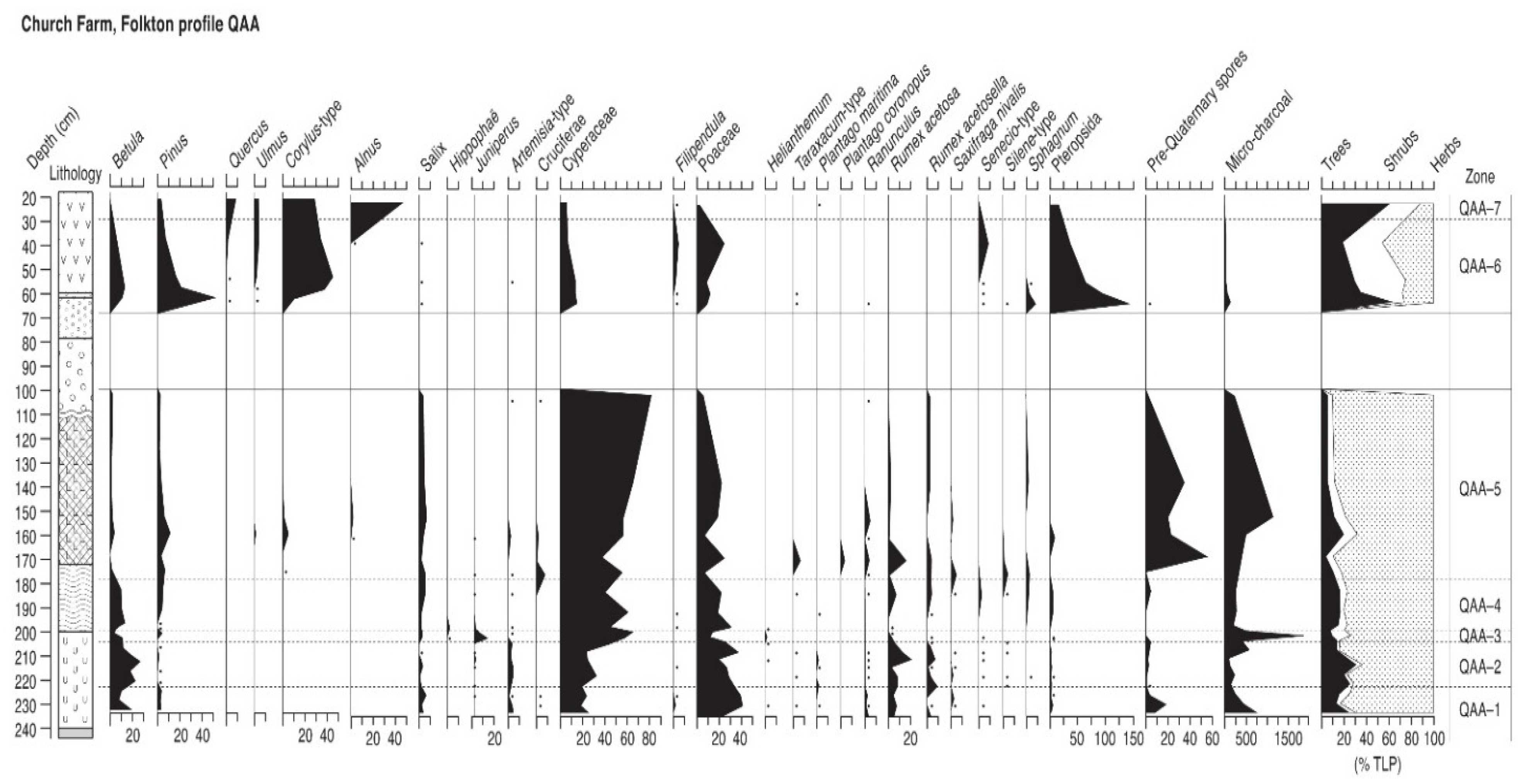
4.9. Church Farm Folkton (Profile QAA)

This site is located at what would have been the south-east edge of palaeolake Flixton (Figure 1). A small excavation trench, termed QAA, behind Folkton Church revealed no archaeology, but sediments from the west-facing side of the trench were recovered using monolith tins. The stratigraphy is shown in Supplementary Table S1. Samples were taken at 2–4 cm intervals in the lowest tin, then at 6–16 cm in the upper tins, depending on the stratigraphy. No samples were taken between 102 and 62 cm where the lithology was entirely clastic. Although able to be counted without difficulty (Figure 10), there was a considerable degree of deterioration of pollen grains throughout the profile, with corrosion and crumpling the main effects. No radiocarbon dates are available for this profile, and correlation with other profiles will be through the tree pollen assemblages.

4.9.1. Pollen Assemblage Zones

The following seven pollen assemblage zones are recognised.
QAA-1
232–222 cm Betula-Salix-Pinus
QAA-2
222–204 cm Betula-Salix
QAA-3
204–197 cm Juniperus-Salix-Betula
QAA-4
197–178 cm Betula-Salix-Pinus
QAA-5
178–102 cm Salix-Pinus
QAA-6
62–28 cm Corylus-Pinus-Betula
QAA-7
28–22 cm Corylus-Alnus-Quercus-Ulmus

4.9.2. Interpretation

Sedimentation began at the edge of a shallow lake, surrounded by a very open landscape with bare soil, as shown by records of pioneer weeds and ruderal pollen, primarily Rumex and Artemisia. There were some Betula and Salix, likely to be partly dwarf species although some patches of tree birch and taller willow scrub would have existed within this sedge-grassland vegetation community. Conditions were cold and the biological productivity of the water body was low, shown by the absence of aquatic pollen. The substantial microcharcoal record shows that fires took place in the area, unless the particles were reworked from earlier soils, as the presence of pre-Quaternary spores, signifying some soil erosion, would support. Radiocarbon dates are unavailable, but the Betula curve suggests that the first four zones of the diagram will date to the latter stages of the Lateglacial Interstadial, with the cold conditions of QAA-1 probably equating with the cold phase around 12,000 14C BP and zone QAA-5 relating to the earlier part of the Lateglacial (Loch Lomond) Stadial (GS-1). Microcharcoal is present at other lake edge sites around palaeolake Flixton, as at Flixton School House Farm [52]. Local, small-scale fires were probably responsible at this site, as microcharcoal frequencies at some contemporaneous sites, including the central lake profile D, are lower. The sharp microcharcoal peak in zone QAA-3 records a significant phase of local burning that mainly affected Betula communities and initially encouraged the spread of Juniperus, which would have replaced Betula directly as well as colonising tall herb-grassland areas, as Poaceae and Rumex also decline sharply, replaced mainly by Cyperaceae. Zone QAA-4 shows a return to the conditions existing before the burning phase, with Juniperus no longer present as Betula regrew in the burned areas and shaded Juniperus out. Pinus also increases and might have been present locally, although at these times pine might well mainly represent longer-distance transport. Hippophaë was briefly present in this regeneration community. Cyperaceae-dominated grassland remained the dominant ground cover. The pollen record of zone QAA-5 records a significant change in local vegetation, as tree and shrub types decline sharply and the landscape became dominated by sedge-grassland with a range of open-ground weeds and tall herbs in a steppe-tundra community. Increases in pre-Quaternary spores and microcharcoal suggest erosion and inwash of soil material from unstable, bare ground. Only Salix maintains percentages and probably represents dwarf willow here. A major climatic deterioration was responsible and this zone represents deposition under the very cold conditions of Loch Lomond Stadial times, dated to between ca. 10,800 and 10,000 14C years ago [63]. The occasional records of thermophilous taxa such as Alnus and Corylus-type, as has been recorded in Lateglacial sediments elsewhere in lowland Yorkshire [77], will probably originate in reworking of earlier interglacial pollen rather than actual presence, although macrofossil evidence for temperate tree taxa in the region at this time makes actual presence a possibility [78], spreading from refugia in northern England [79]. Erosion of inorganic sediments under a severe cold climate culminates in the sediment lying above zone QAA-5, barren of pollen, which comprises coarse grained clastic material including layers of sand and pebbles. This horizon represents solifluction during the coldest phase of the later Lateglacial Stadial.
Organic sedimentation resumed in zone QAA-6 after the Loch Lomond Stadial but was delayed as the rising Corylus-type curve near the start of the zone suggests a time well into the Holocene, with no preceding Juniperus and Betula maxima recorded. A mixed woodland with Betula, Pinus and Ulmus but dominated by Corylus-type characterises this zone, similar to the vegetation of this time at several sites around palaeolake Flixton. Cyperaceae and Poaceae values are much reduced and those herbs were probably restricted to around the wetland edge, where the thermophilous Filipendula became common. Open ground weeds are almost gone from the assemblage, other than a small peak of Senecio–type late in the zone, so that the hazel-dominated woodland might have been almost continuous, on stable soils supporting an understory of Pteropsida. Other than a small microcharcoal peak at the start of the zone, which coincides with the Corylus-type rise and might have aided it locally, fire appears not to have affected this woodland. Zone QAA-7 records a major change in the local vegetation. Alnus woodland expanded rapidly and probably represents carr woodland around the nearby lake edge, with Corylus-type continuing to dominate the drier land, although increased Quercus and Ulmus shows diversification of the local woodland. Fire seems not to have had an influence in the local woodland after the spread of Corylus-type. This big increase in Alnus must represent the start of the mid-Holocene, but the quite wide sampling interval at the top of the diagram means that the rate and character of the spread of mid-Holocene woodland is not well defined here.

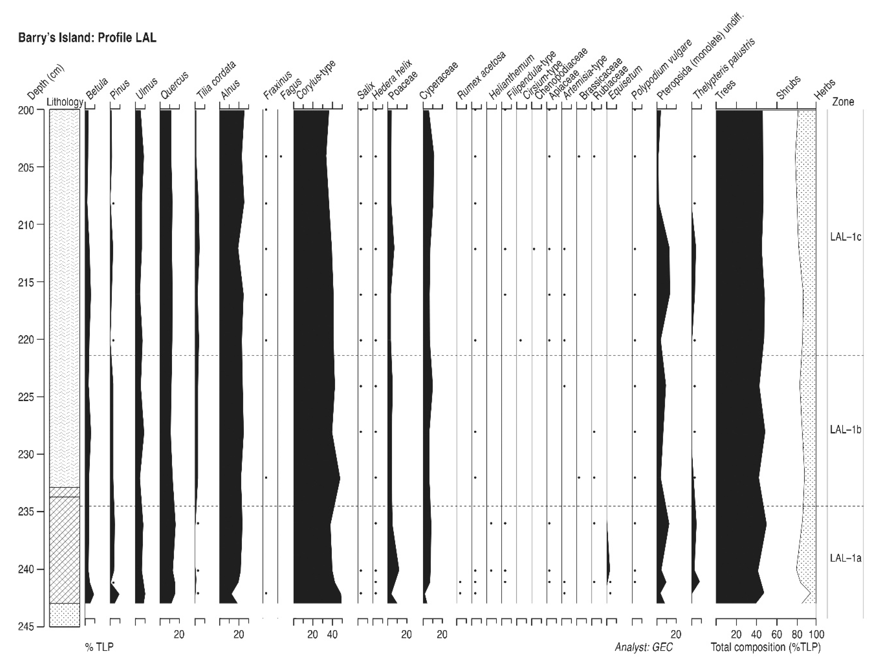
4.10. Barry’s Island (Profile LAL)

Barry’s Island is a mound of glacial gravel and sand deposits which in the earlier Holocene formed an island protruding from the palaeolake in its southeastern corner (Figure 1) and which was submerged by peat as the Holocene progressed. This profile, termed LAL, was taken from an archaeological trench on the western side of the island where the mound slopes gently down into the lake. Sediments were collected in three monolith tins. The stratigraphy is shown in Supplementary Table S1 and consisted of sands overlain in turn by lake muds and carr peat. The bottom 50 cm of the profile was analysed for pollen, with sub-samples taken every four cm through the profile, closing to one cm across the basal transition to lake muds (Figure 11). There are no radiocarbon dates available for this profile, but the chronology can be inferred from the dates in the nearby profile LAP (see below).

4.10.1. Pollen Assemblage Zones

Only one pollen assemblage zone is recognised, subdivided into sub-zones on the diagram to aid interpretation.
LAL-1
244–200 cm Corylus-Alnus-Quercus-Ulmus

4.10.2. Interpretation

This profile contains a very stable vegetation history which hardly changes throughout. There is some variability in the Pinus and Tilia curves, with the former fading away in mid-diagram and the latter rising near the base of the profile, but the curves for these taxa are so low that these changes warrant only sub-zone status. The dominance of Corylus-type and Alnus suggests local abundance of these taxa on the island, on drier ground and on the wetter carr soils at the island’s edge, respectively, within a wider Quercus and Ulmus deciduous woodland. The consistent and substantial values for Alnus and Ulmus indicate peat inception and accumulation during the mid-Holocene between the rise of Alnus about 7000 14C BP (although the date for this pollen-stratigraphic feature is very variable in the eastern Vale, see below) and the decline of Ulmus about 5000 14C BP. The presence of a Tilia curve supports this. The unhumified nature of the detrital peat and the presence of Alnus macrofossils (Supplementary Table S1) suggests quite rapid accumulation within an alder carr environment. Non-arboreal pollen frequencies are very low, although several taxa are recorded, and the woodland canopy remained unbroken, although the presence of isolated grains of Fraxinus and Fagus (a regionally early record) might indicate a small secondary element to the woodland. There is no microcharcoal evidence of local fire, however, so there was no significant disturbance. Perhaps the more isolated location of the Barry’s Island profiles, on a relatively small island, precluded local burning.

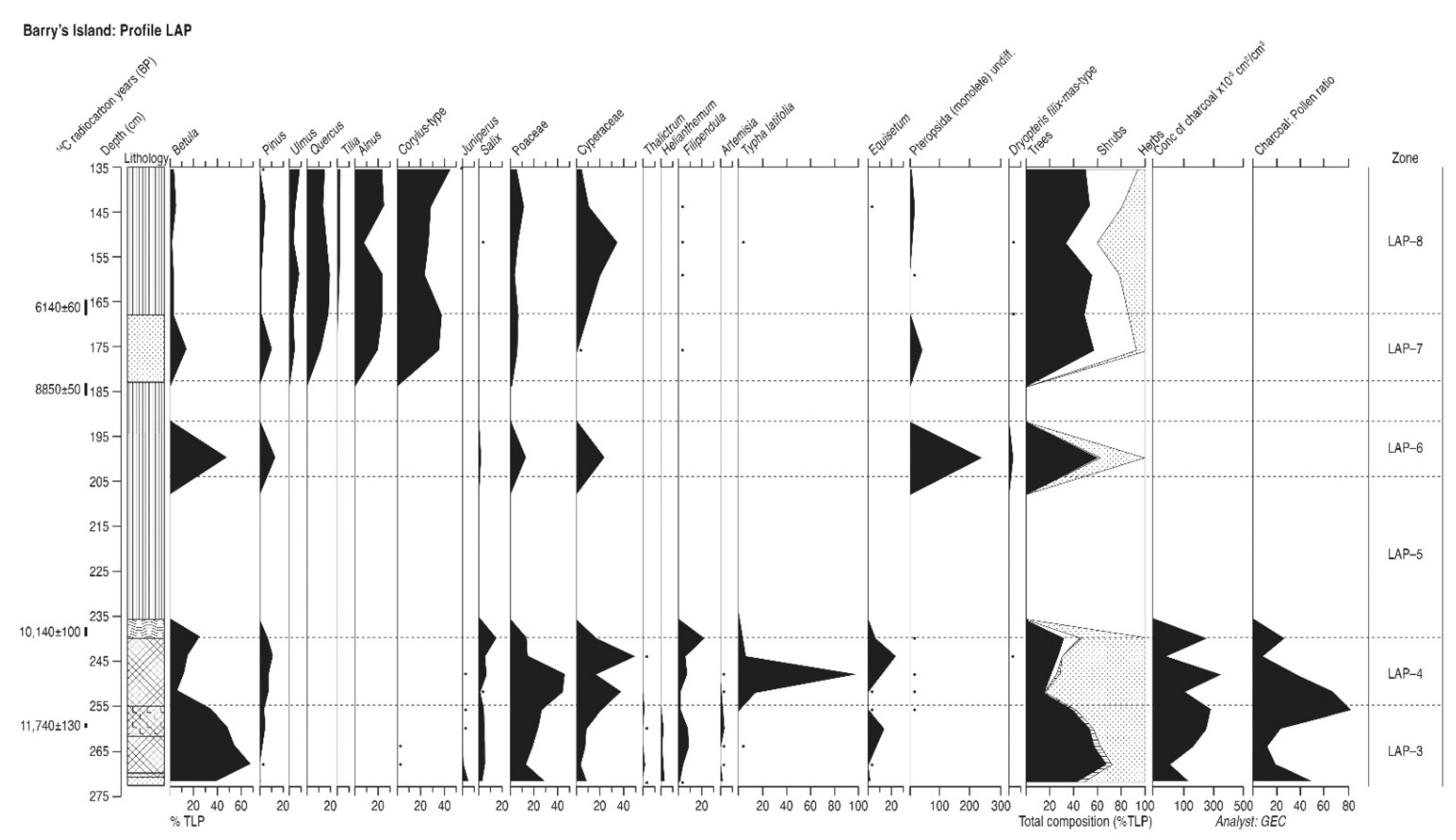
4.11. Barry’s Island (Profile LAP)

A second profile, termed LAP, was recovered from Barry’s Island, at a point in a shallow hollow at its northern edge where the island sloped steeply into the palaeolake. Sediment samples were collected from an archaeological trench using four monolith tins. The succession was sands overlain by lake muds and then by carr peats. Thick sand layers occurred in the peat. These might have been deposited because of the site’s proximity to a deep channel of the present River Derwent which runs past the site and drains to the westward, and which would have been a significant watercourse during the early and mid-Holocene. The main sand layer contained faunal and lithic remains but their condition, and the mixed Early and Late Mesolithic components of the lithics, indicated movement and redeposition in a fluvial environment. The sand layer must have been deposited by a high-energy stream that had reworked older soils and which could have travelled some distance. Particle size analysis shows that the sand layer contained medium and fine sand and was highly sorted. Considering its included bone and flint, it is most likely to be a single, well-sorted flooding event from the nearby stream. The stratigraphy is described in Supplementary Table S1. Sub-samples were taken for pollen analysis every four centimetres. Four samples were submitted for radiocarbon dating and the results are shown in Table 2 and in Figure 12. An Optical Thermoluminescence date 6745 ± 890 BP was obtained (by Dr. Ian Bailiff of the Department of Archaeology, Durham University) on the sand layer between 170 and 180 cm, which conforms with the radiocarbon chronology.

4.11.1. Pollen Assemblage Zones

The following five pollen assemblage zones are recognised.
LAP-1
272–254 cm Betula-Salix-Pinus
LAP-2
254–239 cm Pinus-Betula-Salix
LAP-3
200 cm Betula-Pinus
LAP-4
182–167 cm Corylus-Alnus-Quercus-Pinus
LAP-5
167–135 cm Corylus-Alnus-Quercus-Ulmus

4.11.2. Interpretation

The radiocarbon date near the base of this profile might be too old because of hard water error, but if correct it suggests that sedimentation began in the later mid-Lateglacial (Windermere) Interstadial, probably in the warm phase of GI-1c as there is no evidence in the basal pollen assemblage for cold conditions that could equate with the Older Dryas Stadial phase around 12,000 14C BP which has been recognised to the east of Star Carr [28] and in the lake centre profile D, above. The high Betula frequencies, substantial Filipendula curve and highly organic gyttja sediment (Supplementary Table S1) confirm deposition under a warm climate with an extensive vegetation cover in the late Interstadial temperature maximum although the consistent low curves for steppe taxa Thalictrum, Helianthemum and Artemisia indicate some open ground, perhaps in a type of open park-tundra environment. Similar late Interstadial environments have been recorded elsewhere in north-east Yorkshire, as at Kildale Hall [80,81] and in the Vale of Mowbray [70,82]. The decline of Juniperus and then Betula in zone LAP-2, with the rise of Cyperaceae, Poaceae and the wetland taxa Filipendula and Typha latifolia, suggest either the descent towards the cold conditions of the Lateglacial Stadial, with which zone LAP-2 must correlate, or the advance of local lake-margin wetland communities, or most likely both. The radiocarbon date of 10,140 ± 100 14C BP for the end of zone LAP-2 is acceptable and fits with the pollen stratigraphy. The reed peat in mid-profile is barren of palynomorphs, except for one level in mid-profile which has an early Holocene pollen assemblage, which might result from oxidation of pollen after lake level fluctuation during the transition in depositional environment from aquatic to fen-carr. High fern spore values in this profile might be evidence of a propensity towards corrosion and poor pollen preservation in the earlier Holocene. A clastic sand layer in mid-profile probably represents an erosive event after local stream flooding rather than any climatic cause. There are several streams issuing from the chalk Wolds to the south that entered the lake in the vicinity of Barry’s Island. Increased stream discharge during wetter phases after about 8800 14C BP [83] might have caused erosion and truncation of the profile at about that time. The date of 8850 ± 50 14C BP when pollen deposition recommences shows the upper part of the diagram to be mid-Holocene in age, and the pollen assemblages from zones LAP-4 and LAP-5 agree with that, dominated by Corylus, Quercus, Alnus and Ulmus with Tilia defining the change to zone LAP-5. Barry’s Island must have carried dense deciduous woodland with no evidence of open ground during this mid-Holocene period. This canopy density will account for the absence of microcharcoal at this time, with no burning occurring on the island and more extra-local or regional microcharcoal filtered out by the closed canopy. This agrees well with the evidence from the nearby LAL profile, also without microcharcoal in the mid-Holocene. In the more open vegetation of the Lateglacial at LAP, however, microcharcoal is always present, with a conspicuous peak in frequencies at the start of zone LAP-2, the Lateglacial (Loch Lomond) Stadial. This correlation of burning and the Lateglacial is considered further below.

5. Discussion

5.1. Depositional Environments and Microfossil Data

The pollen assemblages preserved at the eleven profiles described in this paper reflect the taphonomy of the depositional environments at each site. The source area from which pollen and microcharcoal were recruited to the sediment column [84] varied with the hydroseral succession from open water through reedswamp, fen, carr, fenwood and bog as sediment accumulated in the suite of lake margin wetlands as sites became increasingly terrestrialised and vegetation cover became denser [24,25,32]. Lake margin sites, as most of these sites were, would have had source areas on-site and on the adjacent dry land, perhaps of only 30 to 50 metres if they supported closed canopy vegetation [85,86,87]. Profile D at the centre of the palaeolake, however, will have had a much greater pollen source area, likely including pollen rain from much of the eastern Vale and perhaps with contributions from the lower slopes of the adjacent higher ground. One complicating aspect of lake centre sites is that their pollen and microcharcoal assemblages might include material from a range of sources [88], with input streams [89], lake water circulation [90] and reworking of older material leading to focusing and the addition of non-contemporary particles to accumulating deeper water sediments [91,92,93]. Interpretations of vegetation history need to take these factors into account.

5.2. Vegetation History Conspectus

Ten of the eleven new pollen profiles presented in this paper record a vegetation history from sites at the lake margin and cover much of the former lake-edge environment (future research might be required in the north-eastern area, Figure 1). Most of them preserve only a partial record (Figure 13), with only profile QAA containing data from all three Lateglacial, early to mid-Holocene and mid-Holocene (post-Alnus rise) periods. All of the marginal profiles except the two from Barry’s Island, where sediment appears to have been eroded or began to accumulate late, contain an almost full early to mid-Holocene record, however, and most extend that record into the post-Alnus rise Holocene. Together they provide a spatial conspectus which allows comparison of woodland in different parts of the lake’s environs for most of the first half of the Holocene, and which can be compared with the more regional lake centre profile D, and previously published work. The site locations are shown in Figure 14, Figure 15 and Figure 16 and a synopsis of the main pollen assemblages for each of the three periods is shown in Table 3.

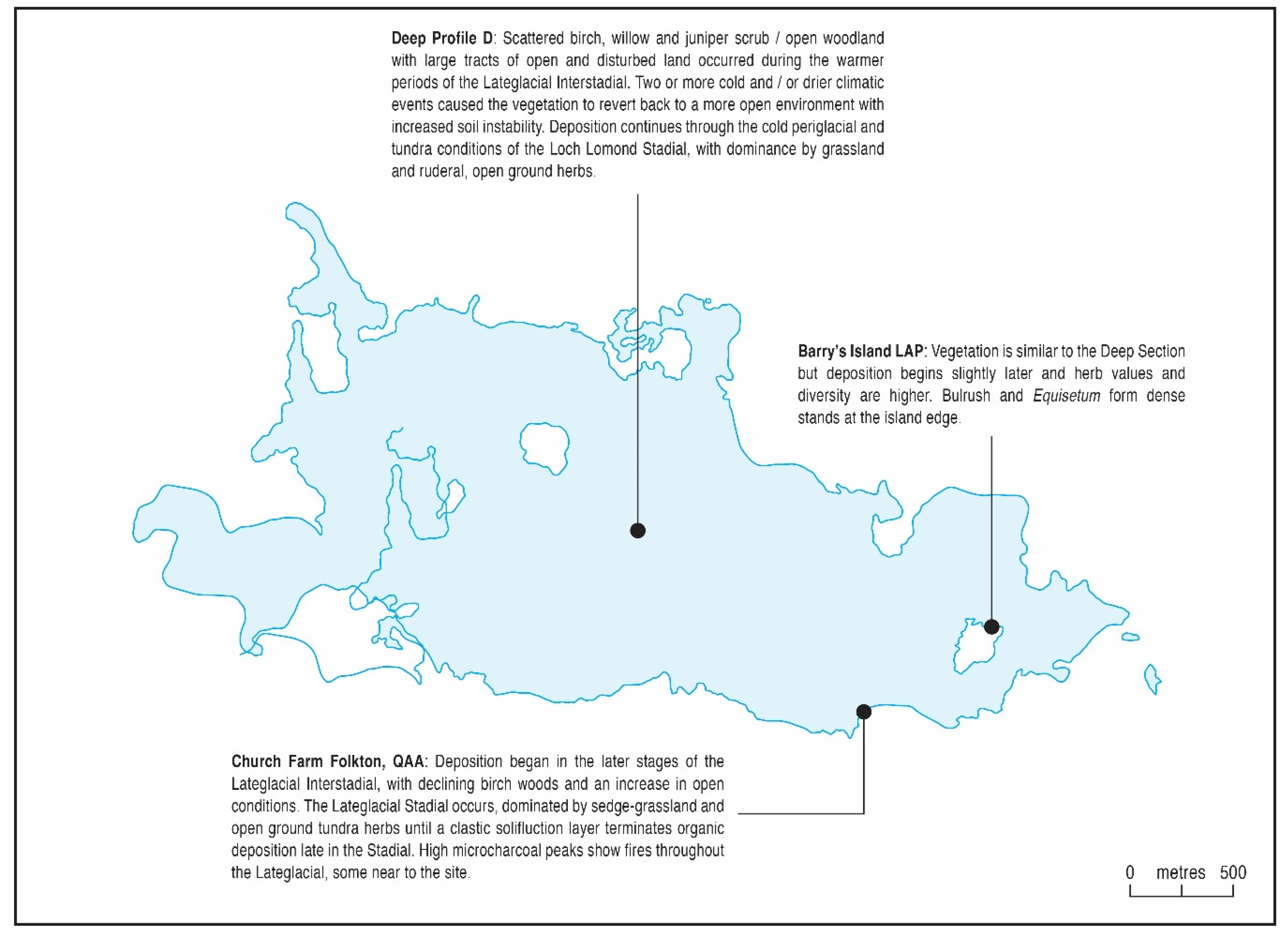
5.2.1. The Lateglacial Period (>10,000 14C BP; zones D 1–4, QAA 4–5 and LAP 1–2)

The three new profiles in this study that contain Lateglacial sediments (Figure 14) are an important addition to the understanding of vegetation history during the pre-Holocene in the eastern Vale of Pickering, extending knowledge to the eastern end of palaeolake Flixton.
It is uncertain whether sediments exist which predate the Lateglacial Interstadial, although the basal levels at the lake centre profile D might well do so, with pollen assemblages indicating very cold conditions, as might the base of the cores of Palmer et al. [46] to the northwest of Flixton Island. Alternatively, these levels could represent a cold phase known to occur during the early Interstadial (GI1-d) [94], but without radiocarbon dating this remains uncertain. It is possible that a similar basal zone dominated by a steppe-tundra flora with Poaceae, Cyperaceae and Artemisia at Flixton School House Farm [52], which has a long Lateglacial sediment sequence, might also preserve pre-Interstadial data, but again is undated. Betula pollen during this severely cold phase could be B. nana. Surveys by Palmer et al. [46,95] show that Lateglacial (Windermere) Interstadial organic sediments occur in most of the deeper basins of palaeolake Flixton, as in other lateglacial lakes in the eastern Vale of Pickering such as at Wykeham Quarry [43]. The whole of the Lateglacial Interstadial warm phase (GI1) is recorded in profile D, as it is in the lake cores of Day [28] and Abrook [26], providing a template for comparison with the lake margin cores that also record pollen data from this phase in the present study, profiles QAA and LAP. Profile D has high frequencies of Betula, over 60%, especially in the later Interstadial, suggesting the development of substantial birch woods in at least parts of the lake’s hinterland. It is supported by similarly high late Interstadial Betula frequencies in Abrook’s nearby diagram [26], almost as high Betula in Day’s diagram [28] and is very similar in abundance to the Betula values recorded at LAP. In contrast the record from QAA for the later part of the Interstadial has low birch and considerable grass, sedge and weed values, and an open vegetation. Cloutman’s work at Seamer Carr [22] showed the Interstadial vegetation in that area, much like QAA, to contain open grassland and scrub, with an extensive herb community, as is also shown by Walker and Godwin’s diagram [10] from Killerby Carr at the east of the lake. There was clearly considerable variability in the Interstadial vegetation at and around the lake. A similarity between these three new profiles is the sharp but brief peaks of Juniperus, otherwise hardly present, with two at profile D and one at QAA and LAP which probably correlate with the later peak at profile D. These juniper peaks signify brief cold phases that caused opening and recession of the birchwoods, and were also recorded by Day [28]. The differences in the ratio of Betula to non-tree pollen in lake margin cores might be due to local factors such as site morphology, with steep-sided island sites such as LAP less likely to develop fringing herbaceous wetland vegetation that would diminish the contribution of the island’s birch woods to the pollen rain, unlike more shallow gradients at sites such as QAA and K2 at Seamer Carr [22]. The Lateglacial (Loch Lomond/Younger Dryas) Stadial (GS1) is represented at the same three new profiles (Figure 13 and Figure 14). These sands or calcareous silts of the Stadial are often devoid of pollen but where present the assemblages contain little evidence of trees, few shrubs and are dominated by grass, sedges and a range of open ground, steppe-tundra herbs. Any Betula and Salix shrub pollen may well represent dwarf varieties, unless tree birches survived in sheltered locations. There seems to have been little spatial variability in this steppe-tundra vegetation around the lake during this severe cold phase and, overall, the Lateglacial pollen evidence from the environs of Lake Flixton appears to be similar to that recorded in other diagrams of this period from Northern England [69].

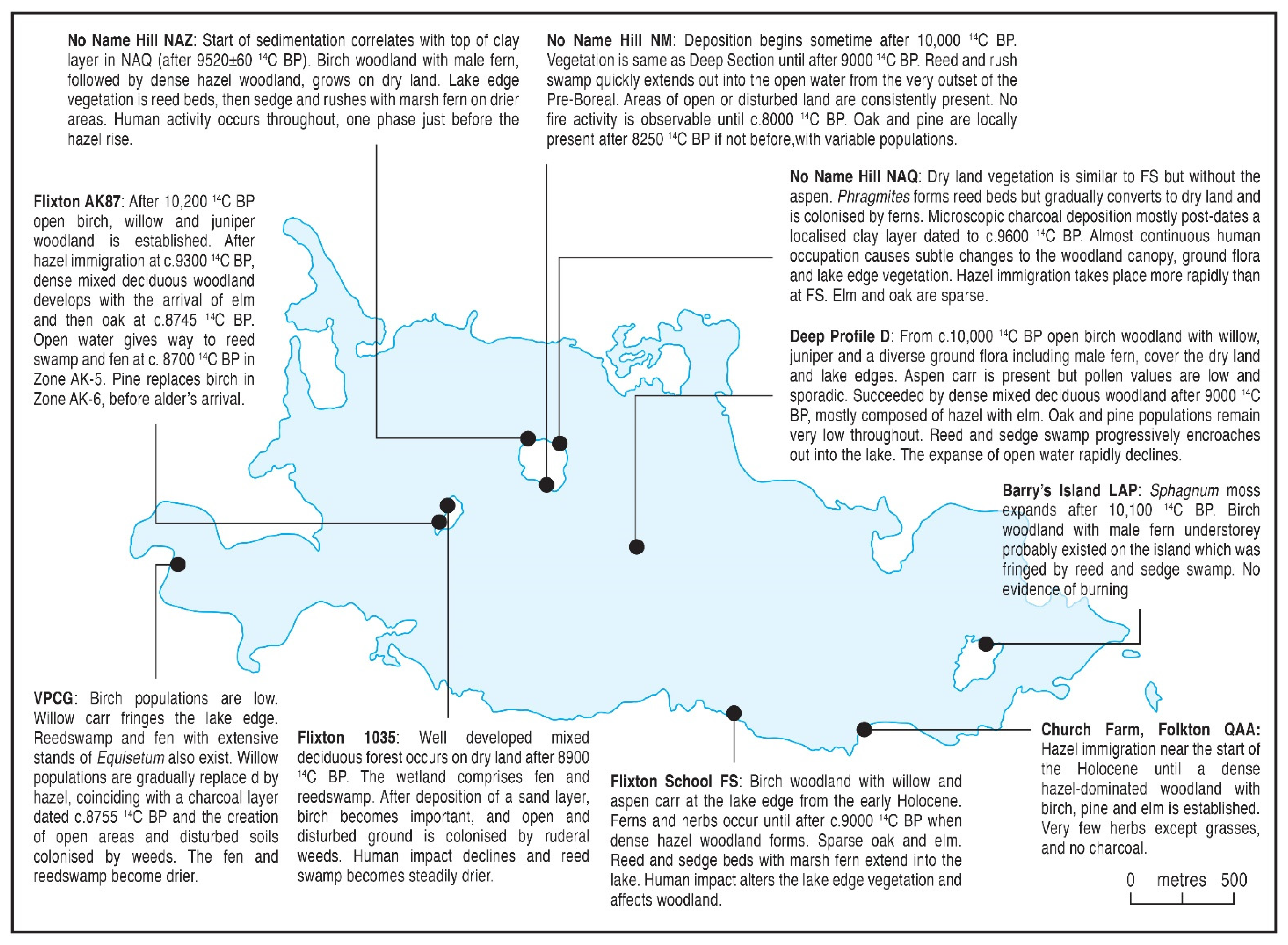
5.2.2. Early to Mid-Holocene (c.10,000 to 7000 14C BP; cf. Pre-Boreal and Boreal)

Early to mid-Holocene pollen stratigraphies are available from nine of the eleven new profiles (Figure 13 and Figure 15), with only the Barry’s Island sites missing because of local sedimentation factors, allowing spatial comparison of woodland history across the whole length of Lake Flixton. That previous pollen studies concentrated on this period because of the rich Early Mesolithic resource means that it has by far the most detailed vegetation history of the area. Lake centre profile D has the more regional pollen signal of woodland history and it indicates that in areas away from local lake margins there was a rapid, transitional succession through tall herb and then shrub communities with Salix and Juniperus. Most of the new profiles that contain pollen from the earliest Holocene include a Juniperus peak as Betula starts to rise, and although this juniper peak varies chronologically [96] it is a clear marker of the expansion of woody taxa about 10,000 14C BP, after which juniper was shaded out by the fully established forest. This had very low levels of tree diversity, with first Betula then Corylus dominating. Their frequencies of over 80% of land pollen must represent firstly closed birch woodland then dense hazel thickets. The establishment of closed Betula forest is not well dated in the Flixton area, but the date of 10,120 ± 180 14C BP at Roos Bog in Holderness [62] will be a good estimation. The birch forest included Salix, Populus and Pinus in favoured locations, and the later dense Corylus woods were slowly penetrated by Ulmus and Quercus. There was one microcharcoal peak in the Corylus phase which coincides with the start of the Ulmus curve and so burning somewhere in the catchment might have facilitated the entry of elm into the forest, but there are no real indicators of disturbance and an unbroken canopy of Betula then of Corylus, with a remarkably swift switch between the two, characterised the woodland of the eastern Vale of Pickering beyond the lake margins. This dryland vegetation history closely follows the pattern recorded by earlier workers at Lake Flixton [10,28] and at sites in the more regional North Yorkshire lowlands of the Tees Valley [66], Holderness [62] and the Vale of Mowbray [76] where pollen values for Betula and Corylus also exceeded 80% of land pollen in this period. In contrast, at the lake margin sites such as on No-Name Hill the switch from Betula to Corylus is often more gradual and somewhat asynchronous, although in general the expansion of Corylus is dated to about 9000 14C BP [18], similar to the rest of northern England [74]. Pinus is present in higher frequencies well into the Corylus phase at marginal sites such as profile FS, Flixton School House Farm [52] and Seamer Carr [22], and the wetland edge areas might well have provided habitats for these trees much longer than in the dryland regional forest, as well as for Salix and other canopy shrub/trees such as Populus and Prunus. Much greater woodland diversity persisted in these lake edge areas than in the wider landscape, perhaps encouraged by human activity, see below, as well as edaphic differences. The immigration of the other major forest trees followed the regional pattern, but Ulmus entered the woodland early in comparison with Quercus, the arrival of which was somewhat delayed and asynchronous, appearing earlier in the south and east than in the northwest, such as at Seamer Carr. Quercus frequencies are also generally lower than in some other sites in the Yorkshire region during this period and, unusually, the major expansion of oak in the regional woods appears to have not occurred until the rise of Alnus pollen around 7000 BP, instead of the c. 8500 BP age recorded more generally in the region [74].

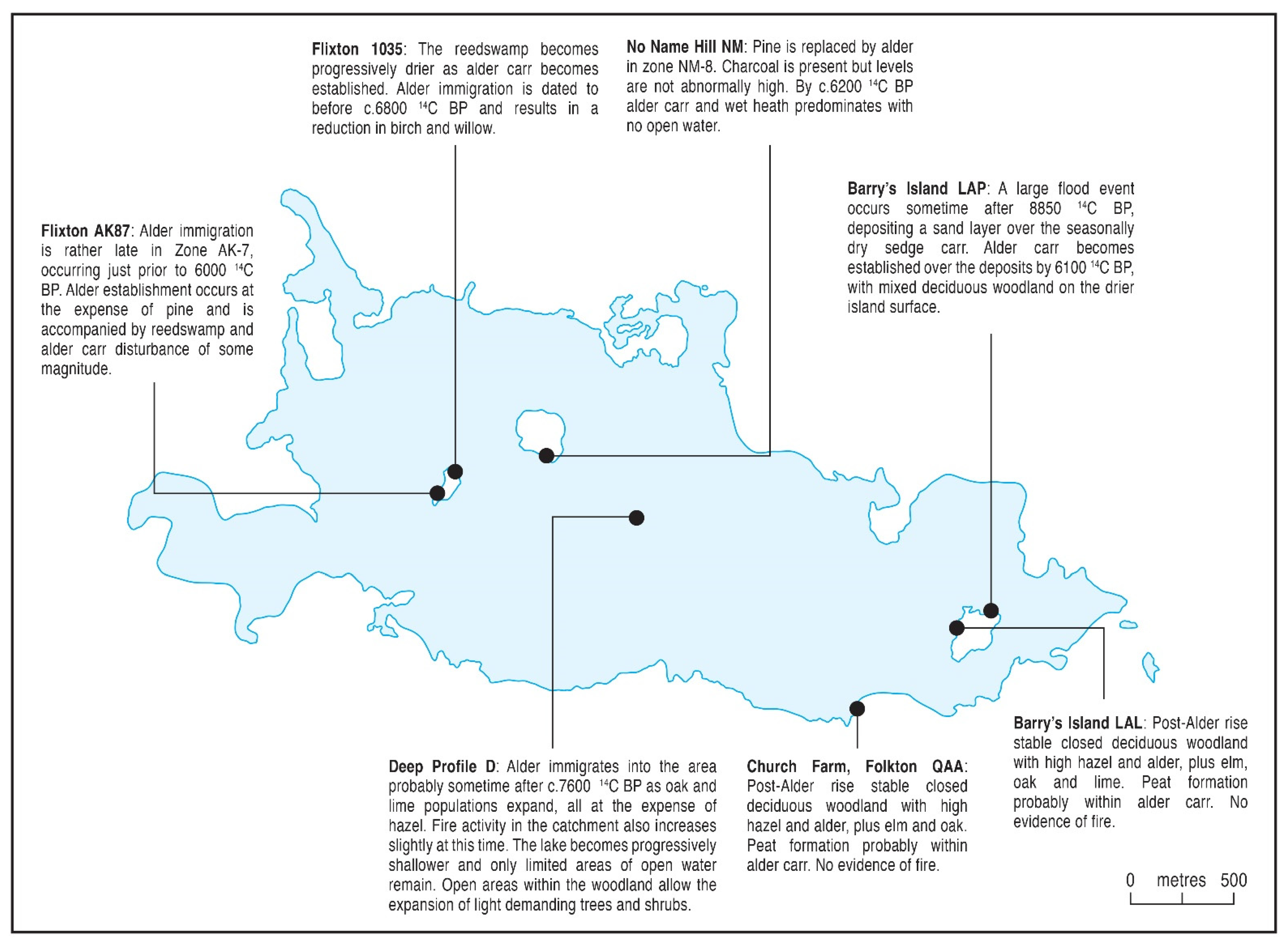
5.2.3. Mid-Holocene c.7000 to 5000 14C BP (cf. Atlantic; Zones D 8, NM 7, AK87 8, 1035 5, QAA 7, LAL 1 and LAP 4–5)

Seven of the new profiles in this study contain sediments of mid-Holocene, post Alnus-rise, age (Figure 13 and Figure 16) and this important pollen stratigraphic change [97,98] is used to define the mid-Holocene period of the Mesolithic. There is aquatic pollen at profile D but not in the more marginal profiles, which contain only the semi-aquatic Typha angustifolia. The lake was almost completely terrestrialised by this time [25], with small areas of shallow open water only in the centre. This would have changed the pollen source area, with a more local pollen rain to profile D and the other lake centre sites, reducing the regional signal. This period saw the completion of the assembly of the regional forest, with Ulmus and Quercus increasing and Alnus becoming a significant component. The timing and degree of the alder expansion was strongly asynchronous, with a very wide range for its rise to high frequencies, and might well have depended on soil conditions, although other triggers for its expansion would have existed, such as disturbance [22]. Alnus’s main role locally was as a dominant in the carr that formed the landward fringe of the lake-edge wetland vegetation as sedimentation continued and wetland successions progressed. The available radiocarbon ages for its expansion show that it was late arriving on the islands in the lake, dating to 5990 ± 90 14C BP at AK87 and 6160 ± 50 14C BP at NM although the date of 6815 ± 110 14C BP at Flixton F1035 is nearer the c. 7000 BP expected age for a lowland site. It was also late at the lake margin site Seamer Carr E77 [22] where its rise dates to c.6470 ± 90 14C BP. It would, however, have also occurred in damper areas of the general forest, and so was probably growing throughout the bottomland woods of the eastern Vale. The population expansion of Alnus is much earlier in the lake centre profiles, however, with an age of 7640 ± 85 14C BP at Day’s site [28], and corroborated by interpolation of ages in profile D, being not very far above a date of 8370 ± 60 14C BP on that diagram. It seems that alder was a significant member of the wider regional forest of the eastern Vale away from the lake, with its pollen recorded in the regional pollen rain of the lake centre diagrams, earlier than the average age for its rational limit in England of about 7000 14C BP, and much earlier than it colonised the lake margin wetlands as part of the hydroseral succession. The soils of the flat lowland Vale were probably favourable to its early appearance, as in other wet valley locations [97,99,100] and it might have been present locally in small numbers much earlier [28]. With a few exceptions, as at profile F1035 and the DB1 core of Walker and Godwin [10], Pinus falls to low values as Alnus rises, as in the new diagrams in this paper and in most earlier studies [22]. This change, traditionally regarded as a marker of the Boreal-Atlantic Transition, probably represents direct replacement of Pinus by Alnus, perhaps on wetland and valley bottom organic soils under a wetter climate regime. Pinus had almost certainly been present in the area, as most pine pollen is deposited within a few hundred metres of the tree, pine resin is present at Star Carr [101] and frequencies of greater than 5% signify local presence [102], although probably in restricted habitats, being consistently recorded in all the early Holocene pollen assemblages in this study and previously [20], and most pine pollen will have been the result of local growth rather than longer distance transport.
At the same time as Alnus rises, Quercus also becomes much more abundant in the general forest, rising sharply in the lake centre profile D, as was noted by Day [28] in her nearby deep core diagram. It seems to have reduced Corylus populations in places, although hazel remained common everywhere, but less so in the island profiles. Ulmus also increases but not to such an extent, having already been present in significant frequencies before the Alnus rise. There is some variability in the composition of the mixed-oak forest but it generally seems stable and with a mostly closed canopy, and more diverse away from the lake margins and islands. There are occasional records of trees that colonise open ground, such as Fraxinus and Betula, suggesting that some parts of the woodland comprised regeneration communities rather than primary forest, perhaps following disturbance. Tilia, the last major member of the mid-Holocene forest to arrive is generally present but in low frequencies, although it increases in the second half of the period. It is near the northern limit of its range [103] and is less important in the eastern Vale than in other parts of North Yorkshire [74].

5.2.4. Later Holocene < 5000 14C BP (cf. Sub-Boreal)

The mid-Holocene Ulmus decline [75] is a major pollen stratigraphic feature which has been recognised in many pollen diagrams in northern England and coincides broadly with the culmination of the transition from Late Mesolithic to Neolithic cultures. It is time-transgressive, occurring in a range of a few centuries before and after 5000 14C years BP [104], with the earlier dates recorded in the lowlands of the region and on better soils, for example 5305 ± 55 14C BP at Morden Carr [105]. There is, however, no convincing evidence of the Ulmus Decline in the present paper’s profiles, nor in previously published pollen diagrams from palaeolake Flixton [26]. This is almost certainly due to the drainage and oxidation of the upper peats in the palaeolake Flixton sequences, with the post-Ulmus decline evidence destroyed. The radiocarbon date of 5300 ± 85 14C BP at the top of the AK87 diagram is very similar to that at Morden Carr but there is no decline in the elm curve although disturbance of alder carr occurs with the creation of open areas colonised by Plantago lanceolata and Pteridium. The Ulmus decline must have been later than 5300 14C BP there. There is an Ulmus decline at profile D with a radiocarbon age of 5740 ± 50 14C BP, but that would be too old for the feature and, as other tree frequencies including Quercus and Alnus fall at the same level, it is an artefact of a sudden rise of non-arboreal frequencies which might have been caused by fire disturbance in the catchment as there is an increase in microcharcoal at this time. The Ulmus decline is therefore not yet represented in palaeolake Flixton vegetation history, and it is not likely that it remains to be discovered in future research. It is possible that pioneer Neolithic agriculturalists were operating in the area in the centuries preceding the Ulmus Decline, as has been postulated for elsewhere in the area [106] at a time early in the transition from the Mesolithic to the Neolithic, but no signs of very early Neolithic-type land use have been found in the eastern Vale of Pickering. More focused, high-resolution palynology [107,108] would be required in late pre-Ulmus Decline peat, as occurs at profile AK87, to look for such evidence.

5.3. Vegetation History Drivers around Lake Flixton

The conclusions regarding vegetation history at palaeolake Flixton derived from the new sites in this paper allow correlation with and refinement of the syntheses published previously [6,7], and discussion of the relative importance of the drivers of Lateglacial and early to mid-Holocene vegetation change in the Vale of Pickering and its environs.

5.3.1. Climate

It is climate change, and primarily temperature variation, that controls vegetation change through the several thousand years of a full Glacial to full Interglacial transition [109,110,111], particularly in a region such as northern England that has suffered extensive ice cover and the most extreme climate changes [38,112]. The major climate shifts that occurred after the end of the full glacial period were generally rapid and stimulated major vegetation change, although often the response of plant communities was delayed because of lags in the rate of soil development and other secondary factors [113], and where their refugia were located [78,114]. The major climatic divisions of the period are well defined [63,67,115], as the Lateglacial (Windermere) Interstadial or Greenland Interstadial GI1, and as the Lateglacial (Loch Lomond) Stadial or GS1 in the Greenland ice core records [65,115]. These were macroscale changes in the northwest Europe region, with GI1 lasting 2000 radiocarbon years and GS1 lasting almost a thousand radiocarbon years. Both climatic phases are recorded in the lake centre cores [26,28] and many of the lake margin profiles at Lake Flixton, discussed in Section 5.2.1 above, as well as in many pollen diagrams in northeast England [45,69,70] with which the Lake Flixton data can be compared, such as Gransmoor, Skipsea Withow Mere and Roos Bog in Holderness [62,64,116], Tadcaster in the Vale of York [117] and Snape Mires in the Vale of Mowbray [70]. These Lateglacial and Holocene climate fluctuations have also been reconstructed in northern England using insects as a sensitive temperature proxy [118,119,120], and the site of Gransmoor [121], close to the Vale of Pickering, has provided a particularly useful climate analogue for Lake Flixton. The vegetation history of the warmest phase of the Interstadial at Lake Flixton corresponds well with that from the wider region, with Betula rising strongly as tree birches colonised the landscape, but with considerable variability in Betula abundance between sites not very far apart. This is similar to the Betula record across northeast England where the maximum birch abundance diminished on a latitudinal gradient from south to north, with closed birch woods in the south and open, patchy park woodland in the north, and can be attributed to temperature differences. The differences in birch abundance around Lake Flixton must have been caused by local edaphic effects or exposure rather than the effects of climate in such a small area, with the main climatic driver tempered by secondary factors.
The profiles that record the Lateglacial Stadial [115] at Lake Flixton indicate the severity of the intensely cold climate in this phase, particularly in its arid latter stages [65], which caused devegetation of many of the slopes around the lake. This sometimes caused a sedimentary hiatus and so no pollen record but often resulted in the erosion and wind distribution of soils and the deposition of clastic layers of sand and clay in some of the lake margin organic sequences, as at QAA and at Seamer Carr [22], but also in lake centre cores [26,28] indicating focusing of solifluction inwash into the deeper parts of the lake. Pre-Quaternary spores in these sediments, such as at QAA, confirm their high degree of reworking, as might their significant charcoal content although the increased incidence of fire in the Lateglacial cold phases is likely to reflect the very arid conditions and increased combustability of vegetation [111,122]. Rapid climate change and temperature fall was certainly the overwhelming cause of vegetation change during the Lateglacial Stadial, with little variability present in the pollen record. The end of the Lateglacial Stadial, with abrupt temperature rise, set in train the immigration of the members of the Interglacial forest community, as everywhere across northern England [74].
While major climate changes governed Lateglacial vegetation communities at the Interstadial and Stadial level, there were also at least three lower amplitude climatic fluctuations in the Interstadial which can be clearly seen in the Greenland ice-core record [63,94,123,124] and at sites in northern England [125,126] and at Lake Flixton as at School House Farm [52]. Cores in the deeper areas of western Lake Flixton [27] have been analysed for high-resolution Oxygen and Carbon stable isotope data [127] which preserve a clear record of these short-lived but intense climate excursions, particularly those in the mid-Interstadial and in the very early Holocene. These events began abruptly, caused vegetation reversals and can be seen in the pollen record at Lake Flixton. Juniperus peaks and sharp Betula declines, and the appearance of steppe-tundra herbs such as Helianthemum and Artemisia, occur in the new profiles at profile D, QAA and LAP which record these brief, centennial-scale cold climate events in the Interstadial in the centuries around 12,000 14C BP and 11,400 14C BP. They have also been recorded by Day [28] and Abrook [26] in their lake centre profiles, showing them to result from regional climate change rather than any local factors, as well as in other regional diagrams [62,66]. These Lateglacial climatic fluctuations have been reconstructed in detail from lake sediments at nearby Wykeham Quarry [128] using a range of well dated temperature-sensitive proxies, as well as in the deep cores of Blockley et al. [27], and confirm the Lake Flixton data in showing that climate was the control on vegetation change during this period.
There were also several considerable climate fluctuations within the general early Holocene warming trend [111], such as the Pre-Boreal Oscillation [34], which greatly complicated forest development, and could slow or even reverse successions towards the naturally closed-canopy and dense [129] temperate deciduous forest. These Holocene fluctuations are clearly visible in the regional climate record [125] and include the rapid onset of cold phases of differing severity that lasted a relatively short time [130] particularly around 9.3 and 8.2 cal. ka BP [131,132], but also around 10.2, 11.1 and 11.4 (the Pre-Boreal Oscillation) cal. ka BP [133,134]. Multi-proxy investigations in western Lake Flixton [46,123,127] have clearly recorded such temperature changes, which logically would have impacted woodland development. Mellars and Dark [1] and Conneller and Higham [135] suggest that the Pre-Boreal Oscillation delayed Mesolithic settlement of the eastern Vale of Pickering by delaying the expansion of woodland, which fits with the dating of Star Carr [13] as after this climatic event. The 9.3 event has also been seen to cause woodland recession [131] and the 8.2 severe cold event had significant impacts on vegetation [136,137] and potentially on Mesolithic settlement [123,138,139,140]. These short-lived early Holocene oscillations are not well represented in the palaeolake Flixton pollen records, perhaps because of the resilience of the woodland with long-lived individual trees [141,142], although there are fluctuations in the Betula and Juniperus curves in some sites that can be interpreted as vegetation reversals, as by Abrook [26], and by Day [28] in her lake centre core where two small peaks of Juniperus coincide with rises in Poaceae and Cyperaceae and falls in Betula. These could record brief recessions of the birchwood and more open shrub, heath and herbaceous vegetation during the Pre-Boreal cold events.
In general, the order in which the major forest trees immigrated into the eastern Vale of Pickering and rose to high populations (the rational pollen limit) is in line with the conventional dated sequence recorded in pollen diagrams all over northern England [143,144,145,146,147,148] and beyond. The Corylus rise is a good example and as its timing in the eastern Vale seems broadly consistent around 9000 14C BP, climate was probably an important driver. It occurred during a period of generally warmer and drier climate [83] which would have favoured hazel expansion [149,150,151,152] and might also have permitted increased natural fire and so increased microcharcoal deposition [153,154], as occurs at lake Flixton (see below). In contrast, some of the timings of woodland population change are very variable, and are very different to the expected regional mean [155,156]. Even when the large standard deviations on some of the radiocarbon dates acquired in the earlier stages of research (Table 2) are taken into account, it is clear that there is a considerable range in the timings for the rise to prominence for some major taxa, especially Alnus, even across the short distances between sites around Lake Flixton. The Alnus rise [97,98,145] has long been attributed to the effects of a change to a wetter, more oceanic climate around 7200 14C BP and proxy data from several studies of bog development in northern England have provided evidence to support a switch to wetter conditions around this time [83,157]. The variability in ages for the Alnus rise, however, suggests that climate was not the main control on alder’s expansion around the lake. The wetlands of the eastern Vale were very complex [25,32] and edaphic factors would have been very important in influencing the ability of taxa such as Alnus, with narrow environmental tolerances, to become established [98,99] and spread around the lake’s environs, and have probably accounted for the very early rise of alder in some wet valley locations [97]. Alnus is often present well before its rise to abundance in Britain [158], awaiting an environmental trigger for its expansion. There was also a pronounced shift to colder and wetter conditions from about 5900 14C BP, recorded in ombrotrophic mires [83,159], which corresponds to increased wetness in the lake Flixton wetlands, although it seems not to have affected the stable regional forest. Overall, once Holocene woodland was established after the early Holocene climatic events it was secondary factors of within-forest competition [160], disturbance [161] and different rates of tree migration [114] that influenced the assembly of the Holocene deciduous forest around Lake Flixton.

5.3.2. Human Impacts

Although climate was the main driver of long-term changes in tree populations in the wider landscape around the Lake Flixton wetlands, other forces such as human activity would have had an impact on woodland succession and composition, and Mesolithic people were certainly operating in the wider landscape [162]. There are indications in the macrofossil wood remains that the Mesolithic inhabitants of the area used a range of woodworking techniques which included the felling of trees around their settlements with axes, as at Star Carr [8,163]. Such removal of individual trees, to provide wood for structures [9,164] and other domestic purposes [165], would probably have been low scale and of very limited extent, with little significant effect on the woodland and so not discernible in pollen diagrams. The main human agency for any significant influence on the forest would have been the use of fire, around settlement and activity sites but also within the wider forest away from the lake itself [2]. While some types of pollen data, curve fluctuations or the appearance of pyrophyte indicator taxa, can be interpreted as reflecting burning, it is charcoal, both macroscopic and microscopic, that is the main and most reliable proxy indicator of burning [166,167]. All size classes of charcoal have been found at the many Mesolithic archaeological sites around the lake edge, including macrocharcoal which must have originated locally, and much of the microcharcoal records might well have originated from on-site domestic activities such as campfires [168]. The dense lake edge reedswamp was apparently a focus of significant burning, near Star Carr [1,169] but in other locations around the lake also [48,170], a practice that has been recorded in the Early Mesolithic elsewhere [171,172] and which might have been commonplace in such situations. Its purpose was most likely to have been to improve access to and from the open water of the lake [2,173], although there would have also been economic benefits [170]. There is also evidence for burning associated with changes in the local woodlands. Fluctuations in birch coinciding with increased levels of microcharcoal occurred during the early Mesolithic at No Name Hill (NAQ) and, to a lesser extent on the southern shore of the lake (FS). In these cases, however, it is uncertain whether the charcoal reflects the intentional burning of local vegetation or is the result of contemporary human activity. A much clearer correlation between woodland change and the use of fire can be seen in VPCG, where increases in charcoal coincide with a decline in willow, which was followed by an increase in hazel. In this case, the presence of worked flints above a corresponding layer of charcoal in the peat stratigraphy makes it likely that humans were responsible for these changes (see below). Charcoal layers also occur in later, Late Mesolithic, contexts at the lake margin. During zones 6 and 7 at No Name Hill (NM), Corylus fluctuates significantly in association with peaks in charcoal, inferring a local and fairly significant presence of later Mesolithic people. The diversity and percentage (c. 15–20%) TLP of the herb layer imply areas of destabilised soil or disturbance. At Seamer Carr sites E77 and K5 Cloutman [22] recorded Late Mesolithic charcoal layers coinciding with the Alnus rise. A black band, peat suffused with charcoal, can be traced in a layer across much of the lakeside area and dates to the Later Mesolithic after about 6500 14C BP, representing consistent burning over a period of several centuries around the lake. Late Mesolithic microcharcoal peaks also occur in profile D and other lake centre cores [26,28].
The Lateglacial sediments investigated in this paper, and in other studies around Lake Flixton, as at Star Carr [6,28], contain large amounts of microscopic charcoal, in fact more than occurs in Holocene sediments. The charcoal frequencies from the Lateglacial sediments at profile LAP are of the same magnitude as those recorded within the lake centre at profile D in zone D-3, suggesting a similar level of burning all around the lake. Such Lateglacial charcoal abundance has been recorded at other sites in North Yorkshire [70,76] and is a common feature of Lateglacial sediments generally [122]. At Flixton School House Farm [52], charcoal layers occurred in the Lateglacial Interstadial associated with declines in Betula pollen percentages, and also in the colder, arid ‘Younger Dryas’ (Loch Lomond) Stadial at the end of the Lateglacial. Day [28] attributed these fires to human activity, which may well be the case, but the Lateglacial was a period of complex and variable climatic conditions [67], with Interstadial cold phases and Younger Dryas Stadial aridity which might have promoted natural fires. The severe cold of the Lateglacial Stadial saw considerable erosion of soils, which could have redeposited old charcoal. It is therefore not possible to attribute the fires that created the charcoal to a particular cause with any certainty. Upper Palaeolithic people were certainly present in the area, with hearths and flints present in organic muds dated to 10,413 ± 210 14C BP beneath Lateglacial Stadial sands at Seamer Carr [15], and it is reasonable to assign some of the charcoal to Upper Palaeolithic activity in a fire-prone environment, as well natural fires under arid climate [111].
There are very many Early Mesolithic archaeological sites around Lake Flixton [6] and a great deal of the charcoal and pollen evidence of vegetation change has been attributed to the activities of those people in the environments fringing the lake [2,20,23,170]. This is not unique, as there are other analogous sites, both regionally and nationally, where evidence of such alteration of the vegetation by fire has been recorded [174], often adjacent to Early Mesolithic flint sites of similar age to Star Carr [175,176,177,178,179]. Bridgland et al. [76] have recorded burning and high charcoal levels in palaeolake sediments at sites in the Vale of Mowbray, a nearby North Yorkshire lowland, which are contemporary with the Star Carr occupation. In palaeolake Flixton, the regional charcoal curve in profile D indicates periods of fire activity within the region and can be used for comparison with the archaeologically linked profiles. Three to four distinct and quite prolonged periods of fire activity can be detected around lake Flixton during the early Mesolithic, for example at No-Name Hill at profile NAQ and at FS on the southern shore of the lake (see also [170]).
Although some of the fires which the charcoal evidence records might have been natural wildfires, a human origin seems very likely. Study of the activities of recent hunter-gatherer societies has shown that the use of fire to modify vegetation was a common practice that was systematic, well planned and integral to their land-use and economic strategies [180,181,182], altering the vegetation to human advantage. The many examples of Mesolithic-age disturbance suggest that early Holocene hunter-gatherers did the same, and their use of fire to diversify the increasingly dense forest would have created a mosaic of areas at different stages of regeneration and improved the range and concentration of plant and animal resources [183]. Fire-disturbance of Betula forest could well have accelerated the rise of Corylus to abundance in the woodland, with the provision of hazelnuts as a staple food source [184], as was clearly the case at profile VPCG where a charcoal layer and the Corylus rise coincide. This is very similar to the start of high charcoal records that coincide with the start of the Corylus curve in sites at Snape Mires in the Vale of Mowbray elsewhere in North Yorkshire [76]. Many other examples of such fire-disturbance of the woodland have been recorded from the areas to the north and south of the Vale of Pickering, on the North York Moors upland especially [107,185,186] but also in the Yorkshire Wolds and Holderness [175,177], many directly associated with charcoal [187]. Charcoal layers and pollen evidence of disturbance are common on the nearby upland of the North York Moors in sediments of Mesolithic age [2,106,187], with microcharcoal studies showing that fire was an ever-present element in the upland woodland ecosystem [188,189]. Similar evidence occurs in other English uplands [190] although, as with the North York Moors, most examples fall into the Later, rather than Early, Mesolithic and so are contemporary with the lake Flixton evidence from sites such as Seamer Carr E77. The early Holocene woodland of the uplands around the Vale of Pickering, however, was probably modified by human action in the same way as the environs of palaeolake Flixton, as the inhabitants of the lakeside Early Mesolithic sites exploited the adjacent uplands [175,191,192].
Whether of human or natural origin, disturbance was an important factor in vegetation change at local scales in both Lateglacial and Holocene times around Lake Flixton, with many sites showing pollen evidence of temporary woodland opening. The pollen and microcharcoal diagrams around the lake margins will record mostly nearby disturbance in lakeside wetland ecosystems and adjacent woodlands because of the local pollen source area, with a muted signal from dryland woods [193,194,195] at any distance from the lake. The lake centre diagrams of Day’s profile D [28] and Blockley [27], must include a more extra-local to regional assemblage, and elevated levels of microcharcoal as indications of burning do exist [28], as at core B [27] where microcharcoal peaks coincide with the rise of Corylus pollen. Overall, however, the lowland woods beyond the immediate lake environs appear to have been less disturbed by comparison with the lake-margin profiles, although distance-decay effects of microcharcoal taphonomy probably will have muted the signal from the wider landscape compared to the near-site impacts in the lake margin profiles.

6. Conclusions

The new profiles presented in this study, particularly those of the eastern part of the palaeolake, move the focus of attention away from the few sites published previously, primarily around Star Carr and Seamer Carr, and provide a more holistic view of vegetation history, including the roles of climate and of possible human impact. The general development of the vegetation in the eastern Vale of Pickering seems characterised by its similarity rather than diversity, although the time-transgressive nature of many of the main early Holocene pollen stratigraphic changes at the sites presented in this paper, in particular the rises of Corylus and Alnus, allied to those of previous research, suggests that factors other than climate change had a significant but local influence on some woodland successions. Edaphic factors in and around the wetland ecosystems fringing palaeolake Flixton would have had an influence, particularly on the spread of alder in the lake margin wetlands but also in the damp bottomland woods of the eastern Vale in general. Human activity, however, in particular burning that in some cases extended beyond the wetlands into the surrounding forest, would also have affected tree populations and distributions, and therefore forest succession and composition. Burning was common around the lake in Early Mesolithic times and occurred in the wider forest in the Later Mesolithic. Often, therefore, local factors such as the gradual development and spread of wetland systems, but especially the activities of the often high populations of Mesolithic hunter-gatherers concentrated around the lake, were instrumental in determining the woodland mosaic and site history and perhaps the timing of woodland composition change at shorter-term temporal and spatial scales. At the more regional scale of tree immigration and spread in the eastern Vale of Pickering, however, Lateglacial and Holocene climate change, both gradual long term and more abruptly during short-term events, was the driver of woodland history as everywhere else in northern England and beyond.

Supplementary Materials

The following supporting information can be downloaded at: https://www.mdpi.com/article/10.3390/quat5040052/s1, Table S1: Stratigraphic description of sediment profiles at Palaeolake Flixton (Depths in cm.); Figure S1: Illustration of The sediment sequence at No-Name Hill, profile NM.

Author Contributions

Conceptualization, Investigation and Writing I.G.S., G.E.C., B.T., J.B.I.; project administration, I.G.S.; Funding acquisition, I.G.S. All authors have read and agreed to the published version of the manuscript.

Funding

GEC’s research was funded by The Leverhulme Trust under project F/128/P and JBI’s by the Vale of Pickering Research Trust.

Institutional Review Board Statement

Not applicable.

Informed Consent Statement

Not applicable.

Data Availability Statement

Data are presented in the paper.

Acknowledgments

We would like to thank the anonymous reviewers for their valuable comments on the manuscript. We are very grateful to Chris Orton of the Cartography Unit, Geography Department, Durham University for producing the figures, and to Ian Bailiff, Archaeology Department, Durham University for the OTL date. Radiocarbon dating was carried out at Hanover, Beta Analytic, Miami and Oxford University. GEC’s research was funded by the Leverhulme Trust under grant F/128/P. We are grateful to the Vale of Pickering Research Trust for their financial and other support over many years, to Tim Schadla-Hall for his encouragement of research in the Vale and to the landowners for access to the sites.

Conflicts of Interest

The authors declare no conflict of interest.

References

  1. Mellars, P.; Dark, S.P. Star Carr in Context; McDonald Institute: Cambridge, UK, 1998. [Google Scholar]
  2. Innes, J.B.; Blackford, J.J.; Simmons, I.G. Mesolithic environments at Star Carr, the eastern vale of Pickering and environs: Local and regional contexts. J. Wetl. Archaeol. 2011, 11, 85–108. [Google Scholar] [CrossRef]
  3. Dark, P. Pollen and preservation at Star Carr: A 60-year perspective. J. Archaeol. Sci. Rep. 2017, 13, 240–248. [Google Scholar] [CrossRef]
  4. Milner, N.; Lane, P.; Taylor, B.; Conneller, C.; Schadla-Hall, T. Star Carr in a postglacial landscape: 60 years of research. J. Wetl. Archaeol. 2011, 11, 1–19. [Google Scholar] [CrossRef]
  5. Milner, N.; Taylor, B.; Conneller, C.; Schadla-Hall, T. Star Carr: Life in Britain after the Ice Age; Council for British Archaeology: York, UK, 2013. [Google Scholar]
  6. Milner, N.; Taylor, B.; Conneller, C. Star Carr Volume 1: A Persistent Place in a Changing World; White Rose University Press: York, UK, 2018. [Google Scholar]
  7. Milner, N.; Taylor, B.; Conneller, C. Star Carr Volume 2: Studies in Technology, Subsistence and Environment; White Rose University Press: York, UK, 2018. [Google Scholar]
  8. Clark, J.G.D. Excavations at Star Carr; Cambridge University Press: Cambridge, UK, 1954. [Google Scholar]
  9. Conneller, C.; Milner, N.; Taylor, B.; Taylor, M. Substantial settlement in the European Early Mesolithic: New research at Star Carr. Antiquity 2012, 86, 1004–1020. [Google Scholar] [CrossRef]
  10. Walker, D.; Godwin, H. Lake stratigraphy, pollen-analysis and vegetational history. In Excavations at Star Carr; Clark, J.G.D., Ed.; Cambridge University Press: Cambridge, UK, 1954; pp. 25–69. [Google Scholar]
  11. Conneller, C.; Milner, N.; Schadla-Hall, T.; Taylor, B. The temporality of the Mesolithic landscape: New work at Star Carr. In Chronology and Evolution within the Mesolithic of North-West Europe; Crombé, P., Van Strydonck, M., Sergant, J., Boudin, M., Bats, M., Eds.; Cambridge Scholars Publishing: Newcastle upon Tyne, UK, 2009; pp. 77–94. [Google Scholar]
  12. Conneller, C.; Milner, N.; Schadla-Hall, R.T.; Taylor, B. Star Carr in the new millenium. In From Bann Flakes to Bushmills. Papers in Honour of Professor Peter Woodman; Finlay, N., McCartan, S., Milner, N., Wickham-Jones, C., Eds.; Prehistoric Society: Oxford, UK, 2009; pp. 78–88. [Google Scholar]
  13. Bayliss, A.; Taylor, B.; Bronk Ramsey, C.; Dunbar, E.; Kromer, B.; Bamforth, M.; Conneller, C.; Elliott, B.; Knight, B.; Milner, N. Dating the archaeology and environment of the Star Carr embayment. In Star Carr Volume 2: Studies in Technology, Subsistence and Environment; Milner, N., Conneller, C., Taylor, B., Eds.; White Rose University Press: York, UK, 2018; pp. 33–112. [Google Scholar]
  14. Schadla-Hall, R.T.; Cloutman, E.W. ‘One cannot dig at random in a peat bog.’ The eastern Vale of Pickering and the archaeology of a buried landscape. In Archaeology from the Ploughsoil; Haselgrove, C.C., Millet, M., Smith, I.M., Eds.; University of Sheffield Department of Archaeology and Prehistory: Sheffield, UK, 1985; pp. 77–86. [Google Scholar]
  15. Schadla-Hall, R.T. Recent investigations of the early Mesolithic landscape in the Vale of Pickering. In Mesolithic Northwest Europe: Recent Trends; Rowley-Conwy, P.A., Zvelebil, M., Blankholm, H., Eds.; University of Sheffield Department of Archaeology and Prehistory: Sheffield, UK, 1987; pp. 46–54. [Google Scholar]
  16. Schadla-Hall, R.T. The Vale of Pickering in the early Mesolithic in context. In The Mesolithic in Europe; Bonsall, C., Ed.; John Donald: Edinburgh, UK, 1989; pp. 218–224. [Google Scholar]
  17. Schadla-Hall, R.T. The Vale of Pickering in the Mesolithic: Uncovering the early post-glacial landscape. Arch. Int. 2000, 4, 11–13. [Google Scholar]
  18. Day, S.P.; Mellars, P. ‘Absolute’ dating of Mesolithic human activity at Star Carr, Yorkshire: New palaeoecological studies and the identification of the 9600 BP radiocarbon ‘plateau’. In Proceedings of the Prehistoric Society; Cambridge University Press: Cambridge, UK, 1994; Volume 60, pp. 417–422. [Google Scholar] [CrossRef]
  19. Conneller, C.; Schadla-Hall, T. Beyond Star Carr: The Vale of Pickering in the 10th millennium BP. Proc. Prehist. Soc. 2003, 69, 85–106. [Google Scholar] [CrossRef]
  20. Dark, P. Palaeoenvironmental investigations. In Star Carr in Context: New Archaeological and Palaeoecological Investigations at the Early Mesolithic site of Star Carr, North Yorkshire; Mellars, P.A., Dark, P., Eds.; McDonald Institute for Archaeological Research: Cambridge, UK, 1998; pp. 111–181. [Google Scholar]
  21. Cloutman, E.W. Palaeoenvironments in the Vale of Pickering. Part 1: Stratigraphy and palaeogeography of Seamer Carr, Star Carr and Flixton Carr. Proc. Prehist. Soc. 1988, 54, 1–19. [Google Scholar] [CrossRef]
  22. Cloutman, E.W. Palaeoenvironments in the Vale of Pickering. Part 2: Environmental history at Seamer Carr. Proc. Prehist. Soc. 1988, 54, 21–36. [Google Scholar] [CrossRef]
  23. Cloutman, E.W.; Smith, A.G. Palaeoenvironments in the Vale of Pickering Part 3: Environmental history at Star Carr. Proc. Prehist. Soc. 1988, 54, 37–58. [Google Scholar] [CrossRef]
  24. Taylor, B. Early Mesolithic activity in the wetlands of the Lake Flixton basin. J. Wetl. Archaeol. 2011, 11, 63–84. [Google Scholar] [CrossRef]
  25. Taylor, B. Early Holocene wetland succession at Lake Flixton (UK) and its implications for Mesolithic settlement. Veget. Hist. Archaeobot. 2019, 28, 559–573. [Google Scholar] [CrossRef] [Green Version]
  26. Abrook, A. Vegetation changes at Palaeolake Flixton during the Late-glacial and early Holocene periods. In The Quaternary of the Vale of Pickering: Field Guide; Lincoln, P., Eddey, L., Matthews, I., Palmer, A., Bateman, M., Eds.; Quaternary Research Association: London, UK, 2017; pp. 129–134. [Google Scholar]
  27. Blockley, S.; Matthews, I.; Palmer, A.; Candy, I.; Kearney, R.; Langdon, P.; Langdon, C.; Abrook, A.; Lincoln, P.; Farry, A.; et al. Climate Research. In Star Carr Volume 2: Studies in Technology, Subsistence and Environment; Milner, N., Conneller, C., Taylor, B., Eds.; White Rose University Press: York, UK, 2018; pp. 113–121. [Google Scholar]
  28. Day, S.P. Devensian Late-Glacial and Early Flandrian environmental history of The Vale of Pickering. J. Quat. Sci. 1996, 11, 9–24. [Google Scholar] [CrossRef]
  29. Innes, J.B. An interim report on stratigraphic and pollen analytical research in the Vale of Pickering. Val. Pick. Res. Trust Newslett. 1994, 1, 4–6. [Google Scholar]
  30. Cummins, G.E. Impacts of Hunter-Gatherers on the Vegetation History of the Eastern Vale of Pickering, Yorkshire. Ph.D. Thesis, Durham University, Durham, UK, 2003. [Google Scholar]
  31. Spikins, P. GIS models of past vegetation: An example from northern England, 10,000–5000 BP. J. Archaeol. Sci. 2000, 27, 219–234. [Google Scholar] [CrossRef]
  32. Taylor, B. Early Holocene wetland succession at Like Flixton. In The Quaternary of the Vale of Pickering: Field Guide; Lincoln, P., Eddey, L., Matthews, I., Palmer, A., Bateman, M., Eds.; Quaternary Research Association: London, UK, 2017; pp. 148–154. [Google Scholar]
  33. Taylor, B.; Elliott, B.; Conneller, C.; Milner, N.; Bayliss, A.; Knight, B.; Bamforth, M. Resolving the issue of artefact deposition at Star Carr. Proc. Prehist. Soc. 2017, 83, 23–42. [Google Scholar] [CrossRef] [Green Version]
  34. Taylor, B.; Blockley, S.; Candy, I.; Langdon, P.; Matthews, I.; Palmer, A.; Bayliss, A.; Milner, N. Climate, environment and Lake Flixton. In Star Carr Volume 1: A Persistent Place in a Changing World; Milner, N., Conneller, C., Taylor, B., Eds.; White Rose University Press: York, UK, 2018; pp. 41–54. [Google Scholar]
  35. Blockley, S. The Flixton area and Star Carr in the context of British Upper Palaeolithic and Early Mesolithic human occupation of Britain. In The Quaternary of the Vale of Pickering: Field Guide; Lincoln, P., Eddey, L., Matthews, I., Palmer, A., Bateman, M., Eds.; Quaternary Research Association: London, UK, 2017; pp. 32–41. [Google Scholar]
  36. Powell, J.H.; Ford, J.R.; Riding, J.B. Diamicton from the Vale of Pickering and Tabular Hills, north-east Yorkshire: Evidence for a Middle Pleistocene (MIS8) glaciation. Proc. Geol. Soc. 2016, 127, 575–594. [Google Scholar] [CrossRef] [Green Version]
  37. Bateman, M.D.; Evans, D.J.A.; Buckland, P.C.; Connell, E.R.; Friend, R.J.; Hartmann, D.; Moxon, H.; Fairburn, W.A.; Panagiotakopulu, E.; Ashurst, R.A. Last glacial dynamics of the Vale of York and North Sea lobes of the British and Irish Ice Sheet. Proc. Geol. Assoc. 2015, 126, 712–730. [Google Scholar] [CrossRef] [Green Version]
  38. Evans, D.J.A.; Clark, C.D.; Mitchell, W.A. The last British ice sheet: A review of the evidence utilised in the compilation of the Glacial Map of Britain. Earth-Sci. Rev. 2005, 70, 253–312. [Google Scholar] [CrossRef] [Green Version]
  39. Evans, D.J.A.; Bateman, M.D.; Roberts, D.H.; Medialdea, A.; Hayes, L.; Duller, G.A.T.; Fabel, D.; Clark, C.D. Glacial Lake Pickering: Stratigraphy and chronology of a proglacial lake dammed by the North Sea Lobe of the British-Irish ice sheet. J. Quat. Sci. 2017, 32, 295–310. [Google Scholar] [CrossRef] [Green Version]
  40. Ford, J.R.; Hughes, L.; Burke, H.F.; Lee, J.R. The Vale of Pickering: An Initial Summary of the Quaternary/Superficial Geology and Data Holdings; British Geological Survey Open Report OR/15/064; British Geological Survey: Nottingham, UK, 2015. [Google Scholar]
  41. Catt, J. The Quaternary of East Yorkshire and adjacent areas. In East Yorkshire Field Guide; Ellis, S., Ed.; Quaternary Research Association: Cambridge, UK, 1987; pp. 1–14. [Google Scholar]
  42. Lincoln, P.; Matthews, I.; Palmer, A.; Blockley, S. Seamer Basin. In The Quaternary of the Vale of Pickering: Field Guide; Lincoln, P., Eddey, L., Matthews, I., Palmer, A., Bateman, M., Eds.; Quaternary Research Association: London, UK, 2017; pp. 87–91. [Google Scholar]
  43. Lincoln, P.; Matthews, I.; Palmer, A.; Blockley, S. Palaeoenvironmental reconstructions from the southern extension of Wykeham Quarry. In The Quaternary of the Vale of Pickering: Field Guide; Lincoln, P., Eddey, L., Matthews, I., Palmer, A., Bateman, M., Eds.; Quaternary Research Association: London, UK, 2017; pp. 103–113. [Google Scholar]
  44. Lincoln, P.; Matthews, I.P.; Palmer, A.P.; Blockley, S.; Staff, R.A.; Candy, I. Hydroclimatic changes in the British Isles through the Last-Glacial-Interglacial Transition: Multiproxy reconstructions from the Vale of Pickering, NE England. Quat. Sci. Rev. 2020, 249, 106630. [Google Scholar] [CrossRef]
  45. Matthews, I.; Abrook, A.; Lincoln, P.; Palmer, A. The Last Glacial Interglacial Transition (16–8 ka BP) in North East England. In The Quaternary of the Vale of Pickering: Field Guide; Lincoln, P., Eddey, L., Matthews, I., Palmer, A., Bateman, M., Eds.; Quaternary Research Association: London, UK, 2017; pp. 23–31. [Google Scholar]
  46. Palmer, A.P.; Matthews, I.P.; Candy, I.; Blockley, S.P.E.; MacLeod, A.; Darvill, C.M.; Milner, N.; Conneller, C.; Taylor, B. The evolution of palaeolake Flixton and the environmental context of Star Carr, NE. Yorkshire: Stratigraphy and sedimentology of the Last Glacial-Interglacial Transition (LGIT) lacustrine sequences. Proc. Geol. Assoc. 2015, 126, 50–59. [Google Scholar] [CrossRef]
  47. Candy, I.; Farry, A.; Darvill, C.M.; Palmer, A.; Blockley, S.P.E.; Matthews, I.P.; MacLeod, A.; Deeprose, L.; Farley, N.; Kearney, R.; et al. The evolution of Palaeolake Flixton and the environmental context of Star Carr: An oxygen and carbon isotopic record of environmental change for the early Holocene. Proc. Geol. Assoc. 2015, 126, 60–71. [Google Scholar] [CrossRef] [Green Version]
  48. Day, S.P. Preliminary results of high-resolution palaeoecological analyses at Star Carr. Cambr. Archaeol. J. 1993, 3, 129–133. [Google Scholar] [CrossRef]
  49. Brown, A.G.; Bradley, C.; Grapes, T.; Boomer, I. Hydrological assessment of Star Carr and the Hertford catchment, Yorkshire, UK. J. Wetl. Archaeol. 2011, 11, 36–55. [Google Scholar] [CrossRef]
  50. Milner, N.; Conneller, C.; Elliott, B.; Koon, B.; Panter, H.; Penkman, K.; Taylor, B.; Taylor, M. From riches to rags: Organic deterioration at Star Carr. J. Archaeol. Sci. 2011, 38, 2818–2832. [Google Scholar] [CrossRef]
  51. Albert, B.M.; Innes, J.B.; Blackford, J.J.; Taylor, B.; Conneller, C.; Milner, N. Degradation of the wetland sediment archive at Star Carr: An assessment of current palynological preservation. J. Arch. Sci. Rep. 2016, 6, 488–495. [Google Scholar] [CrossRef] [Green Version]
  52. Cummins, G.E.; Simmons, I.G. Palaeoecological context of a Bos skeleton from peats at Flixton School House Farm, Vale of Pickering. FORUM Yorks. New Ser. 2013, 2, 21–28. [Google Scholar]
  53. Taylor, B.; Gray Jones, A. Definitely a pit, possibly a house? Recent excavations at Flixton School House Farm in the Vale of Pickering. Mesolith. Misc. 2009, 20, 21–26. [Google Scholar]
  54. Moore, P.D.; Webb, J.A.; Collinson, M.E. Pollen Analysis; Blackwell: Oxford, UK, 1991. [Google Scholar]
  55. Stockmarr, J. Tablets with spores used in absolute pollen analysis. Pollen Spores 1971, 13, 871–873. [Google Scholar]
  56. Edwards, K.J. The separation of Corylus and Myrica pollen in modern and fossil samples. Pollen Spores 1981, 23, 205–218. [Google Scholar]
  57. Grimm, E.C. TILIA Software; Illinois State Museum: Springfield, MA, USA, 1993. [Google Scholar]
  58. Grimm, E.C. TGview; Illinois State Museum: Springfield, MA, USA, 2004. [Google Scholar]
  59. Troels-Smith, J. Characterisation of unconsolidated sediments. Danm. Geol. Unders. Række IV 1955, 3, 1–73. [Google Scholar]
  60. Reimer, P.J.; Bard, E.; Bayliss, A.; Beck, J.W.; Blackwell, P.G.; Bronk Ramsey, C.; Grootes, P.M.; Guilderson, T.P.; Haflidason, H.; Hajdas, I.; et al. IntCal13 and Marine13 radiocarbon age calibration curves 0–50,000 Years cal. BP. Radiocarbon 2013, 55, 1869–1877. [Google Scholar] [CrossRef] [Green Version]
  61. Jacobson, G.L.; Bradshaw, R.H.W. The selection of sites for palaeovegetational studies. Quat. Res. 1981, 16, 80–96. [Google Scholar] [CrossRef]
  62. Beckett, S.C. Pollen diagrams from Holderness, North Humberside. J. Biogeogr. 1981, 8, 177–198. [Google Scholar] [CrossRef]
  63. Björk, S.; Walker, M.J.C.; Cwynar, L.C.; Johnsen, S.; Knudsen, K.-L.; Lowe, J.J.; Wohlfarth, B. Members INTIMATE An event stratigraphy for the Last Termination in the North Atlantic Region based on the Greenland Ice-Core Record: A proposal by the Intimate Group. J. Quat. Sci. 1998, 13, 283–292. [Google Scholar] [CrossRef]
  64. Walker, M.J.C.; Coope, G.R.; Lowe, J.J. The Devensian (Weichselian) Lateglacial palaeoenvironmental record from Gransmoor, East Yorkshire, England: A contribution to the ‘North Atlantic seaboard programme’ of IGCP-253, ‘Termination of the Pleistocene’. Quat. Sci. Rev. 1993, 12, 659–680. [Google Scholar] [CrossRef]
  65. Lowe, J.J.; Ammann, B.; Birks, H.H.; Björck, S.; Coope, G.R.; Cwynar, L.; de Beaulieu, J.-L.; Mott, R.J.; Peteet, D.M.; Walker, M.J.C. Climatic changes in areas adjacent to the North Atlantic during the last glacial-interglacial transition (14-9 ka BP): A contribution to IGCP-253. J. Quat. Sci. 1994, 9, 185–198. [Google Scholar] [CrossRef]
  66. Jones, R.L. Late Quaternary vegetational history of the North York Moors IV: Seamer Carrs. J. Biogeogr. 1976, 3, 397–406. [Google Scholar] [CrossRef]
  67. Walker, M.J.C. Climatic changes in Europe during the Last Glacial/Interglacial Transition. Quat. Int. 1995, 28, 63–76. [Google Scholar] [CrossRef]
  68. Walker, M.J.C. Quaternary Dating Methods; Wiley: Chichester, UK, 2005. [Google Scholar]
  69. Innes, J.B. The Late-glacial record of northern England: Introduction. In Quaternary of Northern England. Geological Conservation Review; Huddart, D., Glasser, N.F., Eds.; Joint Nature Conservation Review Committee: Peterborough, UK, 2002; Volume 25, pp. 211–220. [Google Scholar]
  70. Innes, J.B.; Bridgland, D.R.; Mitchell, W.A.; Rutherford, M.M.; O’Brien, C.; Long, A.J. Late Devensian environments in the Vale of Mowbray, North Yorkshire, UK: Evidence from palynology. Proc. Geol. Assoc. 2009, 120, 199–208. [Google Scholar] [CrossRef]
  71. Gearey, B.R.; Lillie, M.C. Routh Quarry. In The Quaternary of East Yorkshire and North Lincolnshire. Field Guide; Bateman, M.D., Buckland, P.C., Frederick, C.D., Whitehouse, N.J., Eds.; Quaternary Research Association: London, UK, 2001; pp. 69–72. [Google Scholar]
  72. Moore, J.W. Mesolithic sites in the neighbourhood of Flixton, north-east Yorkshire. Proc. Prehist. Soc. 1950, 16, 101–108. [Google Scholar] [CrossRef]
  73. Milner, N.; Taylor, B.; Conneller, C. Excavations at Flixton Island. In The Quaternary of the Vale of Pickering: Field Guide; Lincoln, P., Eddey, L., Matthews, I., Palmer, A., Bateman, M., Eds.; Quaternary Research Association: London, UK, 2017; pp. 140–147. [Google Scholar]
  74. Innes, J.B. Introduction to the Holocene (Flandrian) history and record of Northern England. In Quaternary of Northern England; Huddart, D., Glasser, N.F., Eds.; Geological Conservation Review Series 25; Joint Nature Conservation Committee: Peterborough, UK, 2002; pp. 351–365. [Google Scholar]
  75. Parker, A.G.; Goudie, A.S.; Anderson, D.E.; Robinson, M.A.; Bonsall, C. A review of the mid-Holocene elm decline in the British Isles. Prog. Phys. Geogr. 2002, 26, 1–45. [Google Scholar] [CrossRef]
  76. Bridgland, D.R.; Innes, J.B.; Long, A.J.; Mitchell, W.A. Late Quaternary Landscape Evolution of the Swale-Ure Washlands, North Yorkshire; Oxbow Books: Oxford, UK, 2011. [Google Scholar]
  77. Keen, D.H.; Jones, R.L.; Evans, R.A.; Robinson, J.E. Faunal and floral assemblages from Bingley Bog, West Yorkshire and their significance for Late Devensian and early Flandrian environmental changes. Proc. Yorks. Geol. Soc. 1988, 47, 125–138. [Google Scholar] [CrossRef]
  78. Young, D.S.; Green, C.P.; Batchelor, C.R.; Austin, P.; Elias, S.A.; Athersuch, J.; Lincoln, P. Macrofossil evidence of alder (Alnus sp.) in Britain early in the Late Glacial Interstadial: Implications for the northern cryptic refugia debate. J. Quat. Sci. 2021, 36, 40–55. [Google Scholar] [CrossRef]
  79. Tzedakis, P.C.; Emerson, B.C.; Hewitt, G.M. Cryptic or mystic? Glacial tree refugia in northern Europe. TREE 2013, 28, 696–704. [Google Scholar] [CrossRef] [PubMed] [Green Version]
  80. Jones, R.L. Late Devensian deposits from Kildale, north-east Yorkshire. Proc. Yorks. Geol. Soc. 1977, 41, 185–188. [Google Scholar] [CrossRef]
  81. Jones, R.L. Late Quaternary vegetational history of the North York Moors. V. The Cleveland Dales. J. Biogeogr. 1977, 4, 353–362. [Google Scholar] [CrossRef]
  82. Giles, J.R.A. Late Devensian and early Flandrian environments at Dishforth Bog, north Yorkshire. Proc. Yorks. Geol. Soc. 1992, 49, 1–10. [Google Scholar] [CrossRef]
  83. Hughes, P.D.M.; Mauquoy, D.; Barber, K.E.; Langdon, P.G. Mire-development pathways and palaeoclimatic records from a full Holocene peat archive at Walton Moss, Cumbria, England. Holocene 2000, 10, 465–479. [Google Scholar] [CrossRef]
  84. Bunting, M.J.; Gaillard, M.-J.; Sugita, S.; Middleton, R.; Broström, A. Vegetation structure and pollen source area. Holocene 2004, 14, 651–660. [Google Scholar] [CrossRef]
  85. Bradshaw, R.H.W. Modern pollen representation factors for woods in south-east England. J. Ecol. 1981, 69, 45–70. [Google Scholar] [CrossRef]
  86. Bradshaw, R.H.W. Spatial scale in the pollen record. In Modelling Ecological Change; Harris, D.R., Thomas, K.D., Eds.; Institute of Archaeology, University of London: London, UK, 1991; pp. 41–52. [Google Scholar]
  87. Sugita, S. Pollen representation of vegetation in Quaternary sediments: Theory and method in patchy vegetation. J. Ecol. 1994, 82, 881–897. [Google Scholar] [CrossRef]
  88. Bonny, A.P. The effect of pollen recruitment processes on pollen distribution over the sediment surface of a small lake in Cumbria. J. Ecol. 1978, 66, 385–416. [Google Scholar] [CrossRef]
  89. Pennington, W. The origin of pollen in lake sediments: An enclosed lake compared with one receiving inflow streams. New Phytol. 1979, 83, 189–213. [Google Scholar] [CrossRef]
  90. Davis, M.B. Pollen grains in lake sediments: Redeposition caused by seasonal water circulation. Science 1968, 162, 796–799. [Google Scholar] [CrossRef]
  91. Davis, M.B. Redeposition of pollen grains in lake sediments. Limnol. Oceanogr. 1973, 18, 44–52. [Google Scholar] [CrossRef]
  92. Pennington, W.; Brubaker, L.B. Differential sedimentation of pollen grains in lakes. Limnol. Oceanogr. 1973, 18, 635–646. [Google Scholar]
  93. Bonny, A.P. Recruitment of pollen to the seston and sediment of some lake district lakes. J. Ecol. 1976, 64, 859–887. [Google Scholar] [CrossRef]
  94. Rasmussen, S.O.; Bigler, M.; Blockley, S.P.; Blunier, T.; Buchardt, S.L.; Clausen, H.B.; Cvijanovic, I.; Dahl-Jensen, D.; Johnsen, S.J.; Fischer, H.; et al. A stratigraphic framework for abrupt climatic changes during the last glacial period based on three synchronized Greenland ice-core records: Refining and extending the INTIMATE event stratigraphy. Quat. Sci. Rev. 2014, 106, 14–28. [Google Scholar] [CrossRef] [Green Version]
  95. Palmer, A.P.; Matthews, I.; Candy, I.; Blockley, S.; MacLeod, A.; Darvill, C.; Milner, N.; Conneller, C.; Taylor, B. The bathymetry and lithostratigraphy of sediments in Palaeolake Flixton, North Yorkshire. In The Quaternary of the Vale of Pickering: Field Guide; Lincoln, P., Eddey, L., Matthews, I., Palmer, A., Bateman, M., Eds.; Quaternary Research Association: London, UK, 2017; pp. 124–128. [Google Scholar]
  96. Tipping, R.M. The prospects for establishing synchroneity in the early postglacial pollen peak of Juniperus in the British Isles. Boreas 1987, 16, 155–163. [Google Scholar] [CrossRef]
  97. Chambers, F.M.; Elliott, L. Spread and expansion of Alnus Mill. In the British Isles: Timing, agencies and possible vectors. J. Biogeogr. 1989, 16, 541–550. [Google Scholar] [CrossRef]
  98. Bennett, K.D.; Birks, H.J.B. Postglacial history of alder (Alnus glutinosa (L.) Gaertn.) in the British Isles. J. Quat. Sci. 1990, 5, 123–133. [Google Scholar] [CrossRef]
  99. Bush, M.B.; Hall, A.R. Flandrian Alnus: Expansion or immigration? J. Biogeogr. 1987, 14, 479–481. [Google Scholar] [CrossRef]
  100. Chambers, F.M.; Price, S.-M. palaeoecology of Alnus (alder): Early postglacial rise in a valley mire, north-west Wales. New Phytol. 1985, 101, 333–344. [Google Scholar] [CrossRef]
  101. Croft, S.; Colonese, A.C.; Lucquin, A.; Craig, O.E.; Conneller, C.; Milner, N. Pine traces at Star Carr: Evidence on residues on stone tools. J. Archaeol. Sci. Rep. 2018, 21, 21–31. [Google Scholar] [CrossRef] [Green Version]
  102. Bennett, K.D. Post-glacial dynamics of pine (Pinus sylvestris L.) and pinewoods in Scotland. In Our Pinewood Heritage; Aldhous, J.R., Ed.; Forestry Commission, The Royal Society for the Protection of Birds, Scottish Natural Heritage: Inverness, UK, 1995; pp. 23–29. [Google Scholar]
  103. Pigott, C.D.; Huntley, J.P. Factors controlling the distribution of Tilia cordata at the northern limits of its geographical range. II. History in North-West England. New Phytol. 1980, 84, 145–164. [Google Scholar] [CrossRef]
  104. Griffiths, S. A Bayesian radiocarbon chronology of the early Neolithic of Yorkshire and Humberside. Archaeol. J. 2014, 171, 2–29. [Google Scholar] [CrossRef]
  105. Bartley, D.D.; Chambers, C.; Hart-Jones, B. The vegetational history of parts of south and east Durham. New Phytol. 1976, 77, 437–488. [Google Scholar] [CrossRef]
  106. Simmons, I.G.; Innes, J.B. The ecology of an episode of prehistoric cereal cultivation on the North York Moors, England. J. Archaeol. Sci. 1996, 23, 613–618. [Google Scholar] [CrossRef]
  107. Innes, J.B.; Blackford, J.J.; Simmons, I.G. Late Mesolithic and early Neolithic forest disturbance: A high-resolution palaeoecological test of human impact hypotheses. Quat. Sci. Rev. 2013, 77, 80–100. [Google Scholar] [CrossRef]
  108. Innes, J.B.; Blackford, J.J. Palynology and the study of the Mesolithic-Neolithic transition in the British Isles. In The Archaeological and Forensic Applications of Microfossils: A Deeper Understanding of Human History; Williams, M., Hill, T., Boomer, I., Williamson, I.P., Eds.; Geological Society: London, UK, 2017; pp. 55–78. [Google Scholar]
  109. Birks, H.J.B.; Birks, H.H. The rise and fall of forests. Science 2004, 305, 484–485. [Google Scholar] [CrossRef] [PubMed]
  110. Birks, H.J.B.; Tinner, W. Past forests of Europe. In European Atlas of Forest Tree Species; San-Miguel-Ayanz, J., de Rigo, D., Caudullo, G., Houston Durrant, T., Mauri, A., Eds.; Publ. Office EU: Luxembourg, 2016; pp. 36–39. [Google Scholar]
  111. Abrook, A.; Matthews, I.P.; Candy, I.; Palmer, A.P.; Francis, A.P.; Turner, L.; Brooks, S.J.; Self, A.E.; Milner, A.M. Complexity and asynchrony of climatic drivers and environmental responses during the last Glacial-Interglacial Transition (LGIT) in northwest Europe. Quat. Sci. Rev. 2020, 250, 106634. [Google Scholar] [CrossRef]
  112. Clark, C.D.; Gibbard, P.L.; Rose, J. Pleistocene glacial limits in England, Scotland and Wales. In Quaternary Glaciations—Extent and Chronology: Part 1: Europ; Ehlers, J., Gibbard, P.L., Eds.; Elsevier: Amsterdam, The Netherlands, 2004; pp. 47–82. [Google Scholar]
  113. Pennington, W. Lags in adjustment of vegetation to climate caused by the pace of soil development: Evidence from Britain. Vegetatio 1986, 67, 105–118. [Google Scholar] [CrossRef]
  114. Feurdean, A.; Bhagwat, S.A.; Willis, K.J.; Birks, H.J.B.; Lischke, H.; Hickler, T. Tree migration-rates: Narrowing the gap between inferred post-glacial rates and projected rates. PLoS ONE 2013, 8, e71797. [Google Scholar] [CrossRef]
  115. Lowe, J.J.; Coope, R.G.; Lemdahl, G.; Walker, M.J.C. The Younger Dryas climate signal in land records from NW Europe. In The Younger Dryas; Troelstra, S.R., van Hinte, J.E., Ganssen, G.M., Eds.; Koninklijke Nederlandse Akademie van Wetenschappen: Oxford, UK, 1995; pp. 3–25. [Google Scholar]
  116. Hunt, C.O.; Hall, A.R.; Gilbertson, D.D. The palaeobotany of the Late Devensian sequence at Skipsea Withow Mere. In Late Quaternary Environments and Man in Holderness; Gilbertson, D.D., Ed.; British Archaeological Reports, British Series; BAR Publishing: Oxford, UK, 1984; pp. 81–108. [Google Scholar]
  117. Bartley, D.D. The stratigraphy and pollen analysis of lake deposits near Tadcaster, Yorkshire. New Phytol. 1962, 61, 277–287. [Google Scholar] [CrossRef]
  118. Coope, G.R.; Lemdahl, G.; Lowe, J.J.; Walking, A. Temperature gradients in northern Europe during the last glacial-Holocene transition (14–9 14C kyr BP) interpreted from coleopteran assemblages. J. Quat. Sci. 1998, 13, 419–433. [Google Scholar] [CrossRef]
  119. Jones, R.T.; Marshall, J.D.; Crowley, S.F.; Bedford, A.; Richardson, N.; Bloemendal, J.; Oldfield, F. A high resolution, multiproxy Late-glacial record of climate change and intrasystem responses in northwest England. J. Quat. Sci. 2002, 17, 329–340. [Google Scholar] [CrossRef]
  120. Bedford, A.; Jones, R.T.; Lang, B.; Brooks, S.; Marshall, J.D. A Late-glacial chironomid record from Hawes Water, northwest England. J. Quat. Sci. 2004, 19, 281–290. [Google Scholar] [CrossRef]
  121. Elias, S.A.; Matthews, I.P. A comparison of reconstructions based on aquatic and terrestrial beetle assemblages: Late glacial to Early Holocene temperature reconstructions for the British Isles. Quat. Int. 2014, 341, 69–79. [Google Scholar] [CrossRef] [Green Version]
  122. Edwards, K.J.; Whittington, G.; Tipping, R.M. The incidence of microscopic charcoal in late glacial deposits. Palaeogeogr. Palaeoclimat. Palaeoecol. 2000, 164, 247–262. [Google Scholar] [CrossRef]
  123. Blockley, S.; Candy, I.; Matthews, I.; Langdon, P.; Palmer, A.; Lincoln, P.; Abrook, A.; Taylor, B.; Conneller, C.; Bayliss, A.; et al. The resilience of postglacial hunter-gatherers to abrupt climate change. Nat. Ecol. Evol. 2018, 2, 810–818. [Google Scholar] [CrossRef] [PubMed]
  124. Lowe, J.J.; Birks, H.H.; Brooks, S.J.; Coope, G.R.; Harkness, D.D.; Mayle, F.E.; Sheldrick, C.; Turney, C.S.M.; Walker, M.J.C. The chronology of palaeoenvironmental changes during the last glacial-Holocene transition: Towards an event stratigraphy for the British Isles. J. Geol. Soc. Lond. 1999, 156, 397–410. [Google Scholar] [CrossRef]
  125. Marshall, J.D.; Jones, R.T.; Crowley, S.F.; Oldfield, F.; Nash, S.; Bedford, A. A high-resolution Lateglacial isotopic record from Hawes Water, Northwest England: Climatic oscillations, calibration and comparison of palaeotemperature proxies. Palaeogeogr. Palaeoclimat. Palaeoecol. 2002, 185, 25–40. [Google Scholar] [CrossRef]
  126. Lowe, J.J.; Rasmussen, S.O.; Bjorck, S.; Hoek, W.Z.; Steffensen, J.P.; Walker, M.J.C.; Yu, Z.C.; Grp, I. Synchronisation of palaeoenvironmental events in the North Atlantic region during the Last Termination: A revised protocol recommended by the INTIMATE group. Quat. Sci. Rev. 2008, 27, 6–17. [Google Scholar] [CrossRef]
  127. Candy, I.; Palmer, A.; Blockley, S.; Matthews, I.; MacLeod, A.; Farley, N.; Farry, A.; Kearney, R.; Abrook, A.; Darvill, C. δ13C and δ18O analysis of lacustrine marls from palaeolake Flixton. In The Quaternary of the Vale of Pickering: Field Guide; Lincoln, P., Eddey, L., Matthews, I., Palmer, A., Bateman, M., Eds.; Quaternary Research Association: London, UK, 2017; pp. 135–139. [Google Scholar]
  128. Lincoln, P.; Matthews, I.; Palmer, A.; Blockley, S. Synthesis of records from Wykeham Quarry. In The Quaternary of the Vale of Pickering: Field Guide; Lincoln, P., Eddey, L., Matthews, I., Palmer, A., Bateman, M., Eds.; Quaternary Research Association: London, UK, 2017; pp. 114–123. [Google Scholar]
  129. Mitchell, F.J.G. How open were European primeval forests? J. Ecol. 2005, 93, 168–177. [Google Scholar] [CrossRef]
  130. Rasmussen, S.O.; Vinther, B.M.; Clausen, H.B.; Andersen, K.K. Early Holocene climate oscillations recorded in three Greenland ice cores. Quat. Sci. Rev. 2007, 26, 1907–1914. [Google Scholar] [CrossRef] [Green Version]
  131. van der Plicht, J.; van Geel, B.; Bohncke, S.J.P.; Bos, J.A.A.; Blaauw, M.; Speranza, A.O.M.; Muscheler, R.; Björck, S. The Preboreal climate reversal and a subsequent solar-forced climate shift. J. Quat. Sci. 2004, 19, 263–269. [Google Scholar] [CrossRef]
  132. Fleitmann, D.; Mudelsee, M.; Burns, S.J.; Bradley, R.S.; Kramers, J.; Matter, A. Evidence for a widespread climatic anomaly at around 9.2 ka before present. Paleoceanography 2008, 23, PA1102. [Google Scholar] [CrossRef]
  133. Björck, S.; Rundgren, M.; Ingolfsson, O.; Funder, S. The Preboreal oscillation around the Nordic Seas: Terrestrial and lacustrine responses. J. Quat. Sci. 1997, 12, 455–466. [Google Scholar] [CrossRef]
  134. Björk, S.; Muscheller, R.; Kromer, B.; Andresen, C.S.; Heinemeier, J.; Johnsen, S.J.; Conley, D.; Koç, N.; Spurk, M.; Veski, S. High-resolution analyses of an early Holocene climatic event may imply decreased solar forcing as an important trigger. Geology 2001, 29, 1107–1110. [Google Scholar] [CrossRef]
  135. Conneller, C.; Higham, T. The early Mesolithic colonization of Britain: Preliminary results. In No Stone Unturned: Papers in Honour of Roger Jacobi; Ashton, N., Harris, C.R.E., Eds.; Lithic Studies Society: London, UK, 2015; pp. 157–166. [Google Scholar]
  136. Edwards, K.J.; Langdon, P.G.; Sugden, H. Separating climatic and possible human impacts in the early Holocene: Biotic response around the time of the 8200 cal. BP event. J. Quat. Sci. 2007, 22, 77–84. [Google Scholar] [CrossRef]
  137. Ghilardi, B.; O’Connell, M. Early Holocene vegetation and climate dynamics with particular reference to the 8.2 ka event: Pollen and macrofossil evidence from a small lake in western Ireland. Veget. Hist. Archaeobot. 2013, 22, 99–114. [Google Scholar] [CrossRef]
  138. Wicks, K.; Mithen, S. The impact of the abrupt 8.2 ka cold event on the Mesolithic population of western Scotland: A Bayesian chronological analysis using ‘activity events’ as a population proxy. J. Archeol. Sci. 2014, 45, 240–269. [Google Scholar] [CrossRef]
  139. Griffiths, S.; Robinson, E. The 8.2 ka bp Holocene climate change event and human population resilience in northwest Atlantic Europe. Quat. Int. 2018, 465, 251–257. [Google Scholar] [CrossRef]
  140. Waddington, C.; Wicks, K. Resilience or wipe out? Evaluating the convergent impacts of the 8.2 ka event and Storegga tsunami on the Mesolithic of northeast Britain. J. Archeol. Sci. Rep. 2017, 14, 692–714. [Google Scholar] [CrossRef]
  141. Smith, A.G. Problems of inertia and threshold related to post-glacial habitat changes. Proc. Roy. Soc. Lond. B 1965, 161, 331–342. [Google Scholar]
  142. Von Holle, B.; Delcourt, H.R.; Simberloff, D. The importance of biological inertia in plant community resistance to invasion. J. Veget. Sci. 2003, 14, 425–432. [Google Scholar] [CrossRef] [Green Version]
  143. Hibbert, F.A.; Switsur, V.R.; West, R.G. Radiocarbon dating of Flandrian pollen zones at Red Moss, Lancashire. Proc. R. Soc. Lond. B Biol. Sci. 1971, 177, 161–176. [Google Scholar]
  144. Huntley, B.; Birks, H.J.B. An Atlas of Past and Present Pollen Maps For Europe: 0-13,000 Years Ago; Cambridge University Press: Cambridge, UK, 1983. [Google Scholar]
  145. Birks, H.J.B. Holocene isochrone maps and patterns of tree-spreading in the British Isles. J. Biogeogr. 1989, 16, 503–540. [Google Scholar] [CrossRef]
  146. Huntley, B. Glacial and Holocene vegetation history: Europe. In Vegetation History; Huntley, B., Webb, T., III, Eds.; Kluwer Academic Publishers: Dordrecht, The Netherlands, 1988; pp. 341–383. [Google Scholar]
  147. Huntley, B. European vegetation history: Palaeovegetation maps from pollen data—13 000 yr BP to present. J. Quat. Sci. 1990, 5, 103–122. [Google Scholar] [CrossRef]
  148. Huntley, B. The post-glacial history of British woodlands. In Woodland in the Landscape: Past and Future Perspectives; Atherden, M., Butlin, R.A., Eds.; PLACE Research Centre: York, UK, 1998; pp. 9–25. [Google Scholar]
  149. Linnman, G. Some aspects of the colonization of Corylus avellana L. in north-west Europe during early Flandrian times. Striae 1981, 14, 72–75. [Google Scholar]
  150. Huntley, B. Rapid early-Holocene migration and high abundance of hazel (Corylus avellana L.): Alternative hypotheses. In Climate Change and Human Impact on the Landscape; Chambers, F.M., Ed.; Chapman and Hall: London, UK, 1993; pp. 205–216. [Google Scholar]
  151. Tallantire, P.A. The early-Holocene spread of hazel (Corylus avellana L.) in Europe north and west of the Alps: An ecological hypothesis. Holocene 2002, 12, 81–96. [Google Scholar] [CrossRef]
  152. Seppä, H.; Schurgers, G.; Miller, P.A.; Bjune, A.E.; Giesecke, T.; Kühl, N.; Renssen, H.; Salonen, J.S. Trees tracking a warmer climate: The Holocene range shift of hazel (Corylus avellana) in northern Europe. Holocene 2015, 25, 53–63. [Google Scholar] [CrossRef]
  153. Tipping, R.M. Microscopic charcoal records, inferred human activity and climate change in the Mesolithic of northernmost Scotland. In The Early Prehistory of Scotland; Pollard, T., Morrison, A.M., Eds.; Edinburgh University Press: Edinburgh, UK, 1996; pp. 39–61. [Google Scholar]
  154. Tipping, R.M.; Milburn, P. Mid-Holocene charcoal fall in southern Scotland—Temporal and spatial variability. Palaeogeogr. Palaeoclimatol. Palaeoecol. 2000, 164, 177–193. [Google Scholar] [CrossRef]
  155. Smith, A.G.; Pilcher, J.R. Radiocarbon dates and vegetational history of the British Isles. New Phytol. 1973, 72, 903–914. [Google Scholar] [CrossRef]
  156. Birks, H.J.B. Holocene (Flandrian) chronostratigraphy of the British Isles: A review. Striae 1982, 16, 99–105. [Google Scholar]
  157. Barber, K.E.; Chambers, F.M.; Maddy, D. Holocene palaeoclimates from peat stratigraphy: Macrofossil proxy climate records from three oceanic raised bogs in England and Ireland. Quat. Sci. Rev. 2003, 22, 521–539. [Google Scholar] [CrossRef]
  158. Gieseke, T.; Brewer, S. Notes on the postglacial spread of abundant European tree taxa. Veget. Hist. Archaeobot. 2018, 27, 337–349. [Google Scholar] [CrossRef]
  159. Langdon, P.G.; Barber, K.E.; Hughes, P.D.M. A 7500-year, peat-based palaeoclimatic reconstruction and evidence for an 1100-year cyclicity in bog surface wetness from Temple Hill Moss, Pentland Hills, SE Scotland. Quat. Sci. Rev. 2003, 22, 259–274. [Google Scholar] [CrossRef]
  160. Bennett, K.D.; Lamb, H.F. Holocene pollen sequences as a record of competitive interactions among tree populations. TREE 1988, 3, 141–144. [Google Scholar] [CrossRef]
  161. Brown, A.G. Clearances and clearings: Deforestation in Mesolithic/Neolithic Britain. Ox. J. Archaeol. 1997, 16, 133–146. [Google Scholar] [CrossRef]
  162. Conneller, C. Moving beyond sites: Mesolithic technology in the landscape. In Mesolithic Studies at the Beginning of the 21st Century; Milner, N., Woodman, P., Eds.; Oxbow: Oxford, UK, 2005; pp. 42–55. [Google Scholar]
  163. Taylor, B.; Milner, N.; Conneller, C. Dryland structures. In Star Carr Volume 1: A Persistent Place in a Changing World; Milner, N., Conneller, C., Taylor, B., Eds.; White Rose University Press: York, UK, 2018; pp. 57–121. [Google Scholar]
  164. Bamforth, M.; Taylor, M.; Taylor, B.; Robson, H.K.; Radini, A.; Milner, N. Wooden structures. In Star Carr Volume 1: A Persistent Place in a Changing World; Milner, N., Conneller, C., Taylor, B., Eds.; White Rose University Press: York, UK, 2018; pp. 69–122. [Google Scholar]
  165. Bishop, R.R.; Church, M.J.; Rowley-Conwy, P.A. Firewood, food and human niche construction: The potential role of Mesolithic hunter-gatherers in actively structuring Scotland’s woodlands. Quat Sci. Rev. 2015, 108, 51–75. [Google Scholar] [CrossRef] [Green Version]
  166. Patterson, W.A.; Edwards, K.J.; Maguire, D.J. Microscopic charcoal as a fossil indicator of fire. Quat. Sci. Rev. 1987, 6, 3–23. [Google Scholar] [CrossRef]
  167. Whitlock, C.; Larsen, C. Charcoal as a fire proxy. In Tracking Environmental Change Using Lake Sediments, Vol 3., Terrestrial, Algal, and Siliceous Indicators; Smol, J.P., Birks, H.J.B., Last, W.M., Eds.; Kluwer: Dordrecht, The Netherlands, 2001; pp. 75–97. [Google Scholar]
  168. Bennett, K.D.; Simonson, A.B.; Peglar, S.M. Fire and man in postglacial woodlands of eastern England. J. Archaeol. Sci. 1990, 17, 635–642. [Google Scholar] [CrossRef]
  169. Law, C. The uses and fire-ecology of reedswamp vegetation. In Star Carr in Context; Mellars, P.A., Dark, P., Eds.; McDonald Institute for Archaeological Research: Cambridge, UK, 1998; pp. 197–206. [Google Scholar]
  170. Cummins, G.E. Fire! Accidental or strategic use of fire in the early Mesolithic of the eastern Vale of Pickering. In Mesolithic Lifeways. Current Research in Britain and Ireland; Young, R., Ed.; Leicester Archaeology Monographs No. 7; University Of Leicester: Leicester, UK, 2000; pp. 75–84. [Google Scholar]
  171. Bos, J.A.A.; Urz, R. Late Glacial and early Holocene environment in the middle Lahn river valley (Hessen, central-west Germany) and the local impact of early Mesolithic people—pollen and macrofossil evidence. Veget. Hist. Archaeobot. 2003, 12, 19–36. [Google Scholar] [CrossRef]
  172. Bos, J.A.A.; van Geel, B.; Groenewoudt, B.J.; Lauwerier, R.C.G.M. Early Holocene environmental change, the presence and disappearance of early Mesolithic habitation near Zutphen (The Netherlands). Veget. Hist. Archaeobot. 2005, 15, 27–43. [Google Scholar] [CrossRef]
  173. Rowley-Conwy, P.A. To the upper lake: Star Carr revisited—by birchbark canoe. In Economic Zooarchaeology: Studies in Hunting, Herding and Early Agriculture; Rowley-Conwy, P.A., Serjeantson, D., Halstead, P., Eds.; Oxbow Books: Oxford, UK, 2017; pp. 197–207. [Google Scholar]
  174. Simmons, I.G. The Environmental Impact of Later Mesolithic Cultures; Edinburgh University Press: Edinburgh, UK, 1996. [Google Scholar]
  175. Bush, M.B. Early Mesolithic disturbance: A force on the landscape. J. Arch. Sci. 1988, 15, 453–462. [Google Scholar] [CrossRef]
  176. Moore, J. Forest fire and human interaction in the early Holocene woodlands of Britain. Palaeogeogr. Palaeoclimatol. Palaeoecol. 2000, 164, 125–137. [Google Scholar] [CrossRef]
  177. Tweddle, J.C. Regional vegetational history. In The Quaternary of East Yorkshire and North Lincolnshire Field Guide; Bateman, M.D., Buckland, P.C., Frederick, C.D., Whitehouse, N.J., Eds.; Quaternary Research Association: London, UK, 2001; pp. 35–46. [Google Scholar]
  178. Barnett, C. The chronology of Early Mesolithic occupation and environment impact at Thatcham Reedbeds, southern England. In Chronology and Evolution within the Mesolithic of North-West Europe; Crombé, P., van Strydonck, M., Sergant, J., Boudin, M., Bats, M., Eds.; Cambridge Scholars Publishing: Newcastle upon Tyne, UK, 2009; pp. 57–76. [Google Scholar]
  179. Grant, M.J.; Stevens, C.J.; Whitehouse, N.J.; Norcott, D.; Macphail, R.I.; Langdon, C.; Cameron, N.; Barnett, C.; Langdon, P.G.; Crowder, J.; et al. A palaeoenvironmental context for terminal Upper Palaeolithic and Mesolithic activity in the Colne Valley: Offsite records contemporary with occupation at Three Ways Wharf, Uxbridge. Environ. Arch. 2014, 19, 131–152. [Google Scholar] [CrossRef]
  180. Lewis, H.T. Fire technology and resource management in aboriginal North America and Australia. In Resource Managers: North American and Australian Hunter-Gatherers; Williams, N.M., Hunn, E.S., Eds.; Westview Press: Boulder, CO, USA, 1982; pp. 45–67. [Google Scholar]
  181. Scherjon, F.; Bakels, C.; MacDonald, K.; Roebroeks, W. Burning the land: An ethnographic study of off-site fire use by current and historically documented foragers and implications for the interpretation of past fire practices in the landscape. Curr. Anthropol. 2015, 56, 299–326. [Google Scholar] [CrossRef]
  182. Coughlan, M.R.; Magi, B.I.; Derr, K.M. A global analysis of hunter-gatherers, broadcast fire use, and lightning-fire-prone landscapes. Fire 2018, 1, 41. [Google Scholar] [CrossRef]
  183. Mellars, P. Fire ecology, animal populations and man: A study of some ecological relationships in prehistory. Proc. Prehist. Soc. 1976, 42, 15–45. [Google Scholar] [CrossRef]
  184. Holst, D. Hazelnut economy of early Holocene hunter-gatherers: A case study from Mesolithic Duvensee, northern Germany. J. Archaeol. Sci. 2010, 37, 2871–2880. [Google Scholar] [CrossRef]
  185. Innes, J.B.; Simmons, I.G. Disturbance and diversity: Floristic changes associated with episodes of pre Ulmus-decline woodland recession in north-east Yorkshire. In Archaeology and the Flora of the British Isles; Jones, M., Ed.; Oxford University Press: Oxford, UK, 1988; pp. 7–20. [Google Scholar]
  186. Innes, J.B.; Blackford, J.J.; Simmons, I.G. Woodland disturbance and possible land-use regimes during the Late Mesolithic in the English uplands: Pollen, charcoal and non-pollen palynomorph evidence from Bluewath Beck, North York Moors, UK. Veget. Hist. Archaeobot. 2010, 19, 439–452. [Google Scholar] [CrossRef]
  187. Innes, J.B.; Simmons, I.G. Mid-Holocene charcoal stratigraphy, fire history and palaeoecology at North Gill, North York Moors, UK. Palaeogeogr. Palaeoclimat. Palaeoecol. 2000, 164, 151–165. [Google Scholar] [CrossRef]
  188. Simmons, J.B.; Innes, J.B. Tree remains in a North York Moors peat profile. Nature 1981, 294, 76–78. [Google Scholar] [CrossRef]
  189. Simmons, I.G.; Innes, J.B. Late Quaternary vegetational history of the North York Moors. X. Investigations on East Bilsdale Moor. J. Biogeogr. 1988, 15, 299–324. [Google Scholar] [CrossRef]
  190. Simmons, I.G.; Innes, J.B. Mid-Holocene adaptations and Later Mesolithic forest disturbance in Northern England. J. Archaeol. Sci. 1987, 14, 385–403. [Google Scholar] [CrossRef]
  191. Jones, R.L. The activities of Mesolithic man: Further palaeobotanical evidence from north-east Yorkshire. In Geoarchaeology: Earth Science and the Past; Davidson, D.A., Shackley, M.L., Eds.; Duckworth: London, UK, 1976; pp. 355–367. [Google Scholar]
  192. Jacobi, R.M. Northern England in the eighth millennium BC: An essay. In The Early Post-Glacial Settlement of Northern Europe; Mellars, P., Ed.; Duckworth: London, UK, 1978; pp. 295–332. [Google Scholar]
  193. Bunting, M.J.; Tipping, R.M. Complex hydroseral vegetation succession and ‘dryland’ pollen signals: A case study from northwest Scotland. Holocene 2004, 14, 53–63. [Google Scholar] [CrossRef]
  194. Binney, H.A.; Waller, M.P.; Bunting, M.J.; Armitage, R.A. The interpretation of fen-carr pollen diagrams: The representation of the dry land vegetation. Rev. Palaeobot. Palynol. 2005, 134, 197–218. [Google Scholar] [CrossRef]
  195. Bunting, M.J.; Farrell, M. Seeing the wood for the trees: Recent advances in the reconstruction of woodland in archaeological landscapes using pollen data. Environ. Arch. 2018, 23, 228–239. [Google Scholar] [CrossRef]
Figure 1. Location of palynological sites at Palaeolake Flixton in northeast Yorkshire, UK. Solid triangles are the new sites presented in this paper. Numbered sites are previously published diagrams: 1. Star Carr, 2. Flixton A16, 3. Flixton DB1, 4. Flixton1, Flixton 2 and Flixton KH, 5. Killerby Carr [10] 6. Star Carr [23] 7. Seamer Carr D, 8. Seamer Carr K, 9. Seamer Carr C [21,22] 10. Lake Flixton [20,28] 11. Star Carr M1-M3 [20], Star Carr S24 [51] 12. Flixton School House Farm [52] 13. Cores B and C [27]. Red squares are Mesolithic, including domestic [9,53], sites.
Quaternary 05 00052 g001
Figure 2. Percentage pollen diagram from Profile D. (Analysis GEC).
Quaternary 05 00052 g002
Figure 3. Percentage pollen diagram from No Name Hill, profile NM. (Analysis GEC).
Quaternary 05 00052 g003
Figure 4. Percentage pollen diagram from No Name Hill profile NAQ. (Analysis GEC).
Quaternary 05 00052 g004
Figure 5. Percentage pollen diagram from No Name Hill profile NAZ. (Analysis GEC).
Quaternary 05 00052 g005
Figure 6. Percentage pollen diagram from Flixton profile AK87. (Analysis JBI).
Quaternary 05 00052 g006
Figure 7. Percentage pollen diagram from Flixton Island profile 1035. (Analysis JBI).
Quaternary 05 00052 g007
Figure 8. Percentage pollen diagram from Flixton profile VPCG. (Analysis JBI).
Quaternary 05 00052 g008
Figure 9. Percentage pollen diagram from Flixton School profile FS (Analysis GEC).
Quaternary 05 00052 g009
Figure 10. Percentage pollen diagram from Church Farm Folkton profile QAA. (Analysis GEC).
Quaternary 05 00052 g010
Figure 11. Percentage pollen diagram from Barry’s Island profile LAL. (Analysis GEC).
Quaternary 05 00052 g011
Figure 12. Percentage pollen diagram from Barry’s Island profile LAP. (Analysis GEC).
Quaternary 05 00052 g012
Figure 13. Correlation of pollen assemblage zones from the eleven new profiles at Lake Flixton. Blue shading denotes areas which could not be sampled for pollen because of the core ending, oxidation of upper sections or intrusive sand layers.
Quaternary 05 00052 g013
Figure 14. Correlation of palaeoenvironmental change at this paper’s sites at Palaeolake Flixton >10,000 14C BP (Lateglacial Interstadial and Stadial), derived from zones D 1–4, QAA 4–5 and LAP 1–2.
Quaternary 05 00052 g014
Figure 15. Correlation of palaeoenvironmental change in this paper’s sites at Palaeolake Flixton c.10,000–c. 7000 14C BP (Early to Mid-Holocene–cf. Pre-Boreal and Boreal), derived from zones D 5–7, NM 1–6, NAQ 1–6, NAZ 1–3, AK87 1–7, 1035 1–4, VPCG 1–4, FS 1–7 and QAA 6.
Quaternary 05 00052 g015
Figure 16. Correlation of palaeoenvironmental change at Palaeolake Flixton c.7000–5000 14C BP (Mid-Holocene–cf. Atlantic), derived from zones D 8, NM 7, AK87 8, 1035 5, QAA 7, LAL 1 and LAP 4–5.
Quaternary 05 00052 g016
Table 1. Details of the new pollen sites presented in this paper and located in Figure 1.
SiteUK Grid Ref.Latitude/LongitudeGeographical Location
Lake Centre profile DTA0491809154.21319° N: 0.39278° Wlake centre south-east of No Name Hill
Profile NMTA0400812054.21598° N: 0.40662° Wadjacent to south edge of No Name Hill
Profile NAQTA0402806154.21068° N: 0.40652° Wnorth-east corner of No name Hill
Profile NAZTA0398814954.21859° N: 0.40683° W north-west corner of No name Hill
Profile AK87TA0356810454.21463° N: 0.41342° Wadjacent to Flixton Island, to west
Profile F1035TA0354810754.21491° N: 0.41372° Wwestern edge of Flixton Island
Profile VPCGTA0220808054.21275° N: 0.43435° Wextreme west of Lake Flixton
Profile FSTA0484801354.20620° N: 0.39412° Wat southern edge of Lake Flixton
Profile QAATA0560800054.20488° N: 0.38253° Wat south-eastern edge of Lake Flixton
Profile LALTA0610804054.20837° N: 0.37472° Wwestern edge of Barry’s Island
Profile LAPTA6130804254.20854° N: 0.37425° Wnorthern edge of Barry’s Island
Table 2. Results of radiocarbon dating, on bulk peat unless stated, and radiometric unless shown as AMS.
Depth (cm) Lab Code14C Date (yr. BP)Age Range a (cal. BP)Mean Age a (cal. BP)
Regional profile D
202–209Beta-1044795740 ± 506413–6426; 6436–66566535 ± 122
321–330Beta-1044788370 ± 609149–9168; 9250–95229336 ± 186
Profile NM
12–13Beta-861476160 ± 50 b6906–7175; 7221–72347070 ± 164
70–71.2Beta-861468250 ± 50 b9033–9053; 9081–94079220 ± 187
109–110Beta-861458610 ± 60 b9487–9704; 9724–97319609 ± 122
156–156.6Beta-8614411,400 ± 60 b c13,135–13,39713,265 ± 131
155–157.1Beta-8614311,410 ± 60 b d13,141–13,40613,274 ± 132
Profile AK87
2–4Hv-178215300 ± 855920–6223; 6230–62786099 ± 179
13–15Hv-18296 5990 ± 906637–7070; 7079–71576897 ± 260
74–76Hv-178228710 ± 215 9256–10,2769766 ± 510
98–100Hv-178238745 ± 380 8769–10,789; 11,037–11,0599914 ± 1145
114–116Hv-178249395 ± 21510,182–11,23410,708 ± 525
118–120Hv-178259255 ± 135 10,175–10,792; 10,967–11,065 10,620 ± 445
124–126Hv-1782610,275 ± 12511,411–11,550; 11,602–12,533 11,972 ± 561
Profile F1035
15–17Hv-178276815 ± 1107484–7867; 7901–79247704 ± 220
28–30Hv-178288340 ± 1059035–9050; 9087–95289281 ± 247
49–51OxA-37348930 ± 859744–9756; 9761–10,2369990 ± 245
Profile VPCG
35–37Hv-178298755 ± 2109307–10,298; 10,333–10,3729840 ± 532
40–42Hv-178308435 ± 1958796–8907; 8978–10,1279461 ± 665
Profile NAQ
154–156Beta-1044839810 ± 16010,711–11,81511,263 ± 552
164–166Beta-1044829570 ± 13010,565–11,22410,895 ± 330
Profile NAZ
9–11Beta-1044868850 ± 50 e9737–10,1699953 ± 216
34–37Beta-1044859250 ± 60 f10,258–10,57010,414 ± 156
46Beta-1044849510 ± 60 g 10,591–10,628; 10,649–11,091 10,841 ± 250
Profile LAP
164–167Beta-944386140 ± 606809–6812; 6859–72397024 ± 215
182.5–185Beta-944378850 ± 509737–10,1699953 ± 216
237–239Beta-9443610,140 ± 100 h11,320–12,11311,717 ± 396
258–259Beta-9443511,740 ± 13013,322–13,84413,584 ± 261
Profile FS
262–264Beta-1044819020 ± 60 b9919–10,081; 10,116–10,27210,096 ± 176
265–267Beta-1044809030 ± 60 b9919–10,071; 10,117–10,366 10,142 ± 224
268–269Beta-944349220 ± 100 b10,219–10,607; 10,618–10,657 10,438 ± 219
282–984Beta-944339900 ± 100 b11,157–11,76411,460 ± 304
298–299Beta-9443210,230 ± 100 b11,410–11,435; 11,479–12,398 11,904 ± 494
303–305Beta-9443111,430 ± 100 b13,106–13,48113,294 ± 188
a 2σ age-range and mean calibrations derived using OxCal 4.2 and IntCal13 [60]. b AMS date c wood d Potamogeton seeds. e Corylus nut f Betula wood g Cervus elaphus antler h Sphagnum peat.
Table 3. Synopsis of major vegetation changes and palaeoenvironmental history. Most of the ages for the immigration of the major trees are strongly asynchronous. Quoted ages are in radiocarbon years.
c. 7200–5000 14C BP (Atlantic)
Alnus-Ulmus-Quercus-Corylus
Alnus is added to the tree flora. Its immigration is asynchronous varying from c. 7600 14C BP [28] to c. 6000 14C BP. Tilia appears late in the period. Vegetation disturbance is significant by the end of the mid-Holocene with heliophytic taxa forming a significant contribution to the local (and regional?) pollen rain. Late Mesolithic people were present and human occupation was probably an important factor affecting the development of the vegetation and in some places disturbance might be linked to the local rise of alder. The Ulmus Decline seems not to be recorded. Almost all of the former lake is covered in reed and/or sedge swamp and alder carr and only very small pockets of open water are left in the deepest areas. Microcharcoal is either absent or in very low frequencies and burning was not a significant influence in the damper, denser mid-Holocene forest.
c. 10,000–c.7200 14C BP (Pre-Boreal and Boreal)
Betula (c. 10,000–c.9000) Corylus (c. 9000–c.8000) Corylus-Pinus-Ulmus-Quercus (c. 8000–c. 7200)
Encroachment of lake edge vegetation and reed swamp was rapid and occurred from the earliest point of the Holocene. The importance of Salix and Populus carr is variable around the lake edge although its detection depends to a large extent on pollen preservation and sample location, relative to the water’s edge. After succession through Juniperus and Salix shrubs, Betula dominated the first Holocene millennium. Rapid replacement of Betula by Corylus occurred around 9000 14C BP, with hazel thickets established both locally and regionally. Pinus and Ulmus enter the woodland in places in the centuries leading up to 8000 14C BP. Immigration of Quercus is highly asynchronous, occurring as early as 8700 14C BP at Flixton Island (AK87) but well after 8000 14C BP elsewhere. Early Mesolithic people were present all around the lake and their occupation of the area is envisaged to be continuous throughout, although greatest in the Betula phase and later varying in intensity and location. Detection of vegetation disturbance occurs close to the cultural activity in the Betula phase and further afield during the later phases. Microcharcoal is common near cultural sites in the Betula phase, as well as at the time of the expansion of Corylus, with microcharcoal layers sometimes present as at profile VPCG. It is less prevalent in the later phases.
>10,000 14C BP (Lateglacial)
Poaceae and tundra herbs (>c.13,000) Betula-Poaceae (c.13,000–c.12,000) Juniperus-Poaceae-Betula (c.12,000) Betula (c.12,000–c.11,000) Poaceae-Cyperaceae-tundra herbs (11,000–10,000)
Organic sedimentation began as early as 13,000 14C BP, or even slightly earlier at profile D. Open, tundra-type vegetation was supplanted by open Betula woodland in the first part of the Lateglacial (Windermere) Interstadial. A reversion to Juniperus scrub and grassland occurred under colder conditions around 12,000 14C BP. Denser Betula woodland developed in the later Interstadial. After c.11,000 14C BP in the cold Lateglacial (Loch Lomond) Stadial grassland and tundra-type herbs dominated, with some localised scrub. Microcharcoal frequencies vary but are generally high throughout the Lateglacial, and fire (from whatever source) appears to have played an important part in the environment. Upper Palaeolithic people were present except for the very cold Lateglacial Stadial.
Publisher’s Note: MDPI stays neutral with regard to jurisdictional claims in published maps and institutional affiliations.

