Drones for Conservation in Protected Areas: Present and Future


Abstract
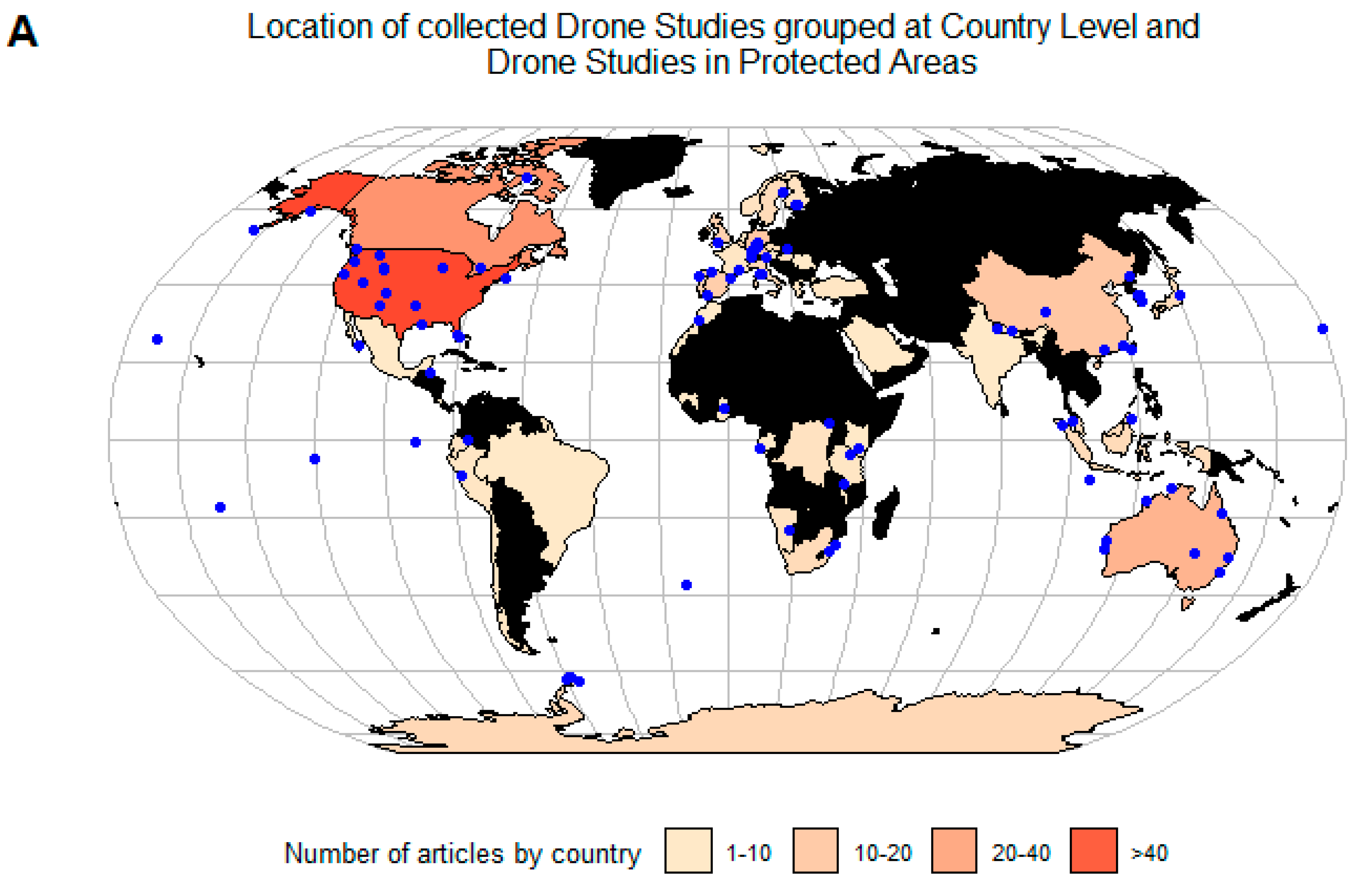
:1. Introduction
2. Methods
3. Results and Discussion
3.1. State of the Art: Drones in Protected Areas
3.1.1. Wildlife Research and Management
3.1.2. Ecosystem Monitoring
3.1.3. Law Enforcement
3.1.4. Ecotourism
3.1.5. Environmental Management and Disaster Response
3.2. Current Challenges on the Integration of Drones in Protected Areas
3.2.1. Legal Barriers and Ethical Constraints
3.2.2. Impact of Drones on Wildlife and Ecosystems
3.2.3. Costs of Drone Operation
3.2.4. Technological Challenges
3.3. Linking Drone Platforms and Sensors with Conservation
3.4. Knowledge Gaps and Recommendations for Future Research
Supplementary Materials
Author Contributions
Funding
Acknowledgments
Conflicts of Interest
References
- Dudley, N. Guidelines for Protected Area Management Categories; IUCN: Gland, Switzerland, 2008; Volume 3, ISBN 978-2-8317-1086-0. [Google Scholar]
- Watson, J.E.M.; Dudley, N.; Segan, D.B.; Hockings, M. The performance and potential of protected areas. Nature 2014, 515, 67–73. [Google Scholar] [CrossRef] [PubMed]
- Juffe-Bignoli, D.; Burgess, N.D.; Bingham, H.; Belle, E.M.S.; de Lima, M.G.; Deguignet, M.; Bertzky, B.; Milam, N.; Martinez-Lopez, J.; Lewis, E.; et al. Protected Planet Report 2014; UNEP-WCMC: Cambridge, UK, 2014; ISBN 9789280734164. [Google Scholar]
- Gonçalves, J.; Henriques, R.; Alves, P.; Sousa-Silva, R.; Monteiro, A.T.; Lomba, Â.; Marcos, B.; Honrado, J. Evaluating an unmanned aerial vehicle-based approach for assessing habitat extent and condition in fine-scale early successional mountain mosaics. Appl. Veg. Sci. 2016, 19, 132–146. [Google Scholar] [CrossRef]
- Lopoukhine, N.; Crawhall, N.; Dudley, N.; Figgis, P.; Karibuhoye, C.; Laffoley, D.; Londoño, J.M.; MacKinnon, K.; Sandwith, T. Protected areas: providing natural solutions to 21st Century challenges. Surveys and Perspectives Integrating Environment and Society 2012, 5, 1–16. [Google Scholar] [CrossRef]
- Pimm, S.L.; Alibhai, S.; Bergl, R.; Dehgan, A.; Giri, C.; Jewell, Z.; Joppa, L.; Kays, R.; Loarie, S. Emerging technologies to conserve biodiversity. Trends Ecol. Evol. 2015, 30, 685–696. [Google Scholar] [CrossRef] [PubMed]
- Melesse, A.; Weng, Q.; Prasad, S.; Senay, G. Remote Sensing Sensors and applications in environmental resources mapping and modelling. Sensors 2007, 7, 3209–3241. [Google Scholar] [CrossRef] [PubMed]
- Whitehead, K.; Hugenholtz, C.H. Remote sensing of the environment with small unmanned aircraft systems (UASs), part 1: A review of progress and challenges. J. Unmanned Veh. Syst. 2014, 2, 69–85. [Google Scholar] [CrossRef]
- Rodríguez, A.; Negro, J.J.; Mulero, M.; Rodríguez, C.; Hernández-Pliego, J.; Bustamante, J. The Eye in the Sky: Combined Use of Unmanned Aerial Systems and GPS Data Loggers for Ecological Research and Conservation of Small Birds. PLoS One 2012, 7. [Google Scholar] [CrossRef]
- Linchant, J.; Lisein, J.; Semeki, J.; Lejeune, P.; Vermeulen, C. Are unmanned aircraft systems (UASs) the future of wildlife monitoring? A review of accomplishments and challenges. Mamm. Rev. 2015, 45, 239–252. [Google Scholar] [CrossRef]
- Christie, K.S.; Gilbert, S.L.; Brown, C.L.; Hatfield, M.; Hanson, L. Unmanned aircraft systems in wildlife research: Current and future applications of a transformative technology. Front. Ecol. Environ. 2016, 14, 241–251. [Google Scholar] [CrossRef]
- Mulero-Pázmány, M.; Stolper, R.; Van Essen, L.D.; Negro, J.J.; Sassen, T. Remotely piloted aircraft systems as a rhinoceros anti-poaching tool in Africa. PLoS One 2014, 9, 1–10. [Google Scholar] [CrossRef]
- Koh, L.P.; Wich, S.A. Dawn of drone ecology: low-cost autonomous aerial vehicles for conservation. Trop. Conserv. Sci. 2012, 5, 121–132. [Google Scholar] [CrossRef]
- Chabot, D.; Bird, D.M. Wildlife research and management methods in the 21st century: Where do unmanned aircraft fit in? J. Unmanned Veh. Syst. 2015, 3, 137–155. [Google Scholar] [CrossRef] [Green Version]
- Schofield, G.; Katselidis, K.A.; Lilley, M.K.S.; Reina, R.D.; Hays, G.C. Detecting elusive aspects of wildlife ecology using drones: new insights on the mating dynamics and operational sex ratios of sea turtles. Funct. Ecol. 2017, 38, 42–49. [Google Scholar] [CrossRef]
- Näsi, R.; Honkavaara, E.; Lyytikäinen-Saarenmaa, P.; Blomqvist, M.; Litkey, P.; Hakala, T.; Viljanen, N.; Kantola, T.; Tanhuanpää, T.; Holopainen, M. Using UAV-based photogrammetry and hyperspectral imaging for mapping bark beetle damage at tree-level. Remote Sens. 2015, 7, 15467–15493. [Google Scholar] [CrossRef]
- Wang, D.; Xin, X.; Shao, Q.; Brolly, M.; Zhu, Z.; Chen, J. Modeling aboveground biomass in Hulunber grassland ecosystem by using unmanned aerial vehicle discrete lidar. Sensors 2017, 17, 180. [Google Scholar] [CrossRef] [PubMed]
- Villa, T.; Gonzalez, F.; Miljievic, B.; Ristovski, Z.; Morawska, L. An overview of small unmanned aerial vehicles for air quality measurements: Present applications and future prospectives. Sensors 2016, 16, 1072. [Google Scholar] [CrossRef] [PubMed]
- Pádua, L.; Vanko, J.; Hruška, J.; Adão, T.; Sousa, J.J.; Peres, E.; Morais, R. UAS, sensors, and data processing in agroforestry: a review towards practical applications. Int. J. Remote Sens. 2017, 38, 2349–2391. [Google Scholar] [CrossRef] [Green Version]
- Hassanalian, M.; Abdelkefi, A. Classifications, applications, and design challenges of drones: A review. Prog. Aerosp. Sci. 2017, 91, 99–131. [Google Scholar] [CrossRef]
- Colomina, I.; Molina, P. Unmanned aerial systems for photogrammetry and remote sensing: A review. ISPRS J. Photogramm. Remote Sens. 2014, 92, 79–97. [Google Scholar] [CrossRef] [Green Version]
- Adão, T.; Hruška, J.; Pádua, L.; Bessa, J.; Peres, E.; Morais, R.; Sousa, J. Hyperspectral imaging: A review on uav-based sensors, data processing and applications for agriculture and forestry. Remote Sens. 2017, 9, 1110. [Google Scholar] [CrossRef]
- Brown, A. Grand Canyon Park Rangers Use Drones to Search for Missing Hikers. Available online: http://www.thedrive.com/aerial/9619/grand-canyon-park-rangers-use-drones-to-search-for-missing-hikers?# (accessed on 27 September 2018).
- Margaritoff, M. Australian Rangers Use Drones to Monitor and Protect Endangered Turtles From Predators. Available online: http://www.thedrive.com/tech/22747/australian-rangers-use-drones-to-monitor-and-protect-endangered-turtles-from-predators (accessed on 26 September 2018).
- Richmond, B.C. Drones, dogs and DNA the latest weapons against invasive species. Available online: https://www.theglobeandmail.com/news/national/drones-dogs-and-dna-the-latest-weapons-against-invasive-species/article28531824/ (accessed on 27 September 2018).
- Beaubien, J. Eyes In The Sky: Foam Drones Keep Watch On Rain Forest Trees. Available online: https://www.npr.org/sections/goatsandsoda/2015/05/19/398765759/eyes-in-the-sky-styrofoam-drones-keep-watch-on-rainforest-trees?t=1540327094055 (accessed on 28 September 2018).
- Crooks, J. Drone Collects Information to Benefit Great Lakes. Available online: https://www.fs.fed.us/blogs/drone-collects-information-benefit-great-lakes (accessed on 27 September 2018).
- Nuwer, R. High Above, Drones Keep Watchful Eyes on Wildlife in Africa. Available online: https://www.nytimes.com/2017/03/13/science/drones-africa-poachers-wildlife.html (accessed on 27 September 2018).
- Kohler, P. Launching the Marine Litter DRONET. Available online: https://www.theplastictide.com/blog-1/2018/4/22/launching-the-marine-litter-dronet (accessed on 22 September 2018).
- Cirino, E. Drones Help Find Massive Penguin Colonies Hiding in Plain Sight. Available online: https://www.newsdeeply.com/oceans/articles/2018/03/05/drones-help-find-massive-penguin-colonies-hiding-in-plain-sight (accessed on 18 September 2018).
- DRONE HOPPER, S.L. Drone Hopper | Firefigthing Drone. Available online: https://www.drone-hopper.com/home (accessed on 2 September 2018).
- Apprill, A.; Miller, C.A.; Moore, M.J.; Durban, J.W.; Fearnbach, H.; Barrett-Lennard, L.G. Extensive Core Microbiome in Drone-Captured Whale Blow Supports a Framework for Health Monitoring. mSystems 2017. [Google Scholar] [CrossRef] [PubMed]
- Foxx, C. Drones scatter mosquitoes to fight diseases. Available online: https://www.bbc.co.uk/news/technology-42066518 (accessed on 21 September 2018).
- Stone, E. Drones Spray Tree Seeds From the Sky to Fight Deforestation. Available online: https://news.nationalgeographic.com/2017/11/drones-plant-trees-deforestation-environment/?user.testname=none (accessed on 21 September 2018).
- Mulero-Pázmány, M.; Jenni-Eiermann, S.; Strebel, N.; Sattler, T.; Negro, J.J.; Tablado, Z. Unmanned aircraft systems as a new source of disturbance for wildlife: A systematic review. PLoS One 2017, 12, e0178448. [Google Scholar] [CrossRef] [PubMed]
- Sandbrook, C. The social implications of using drones for biodiversity conservation. Ambio 2015, 44, 636–647. [Google Scholar] [CrossRef] [Green Version]
- Manfreda, S.; McCabe, M.F.; Miller, P.E.; Lucas, R.; Madrigal, V.P.; Mallinis, G.; Ben Dor, E.; Helman, D.; Estes, L.; Ciraolo, G.; et al. On the use of unmanned aerial systems for environmental monitoring. Remote Sens. 2018, 10. [Google Scholar] [CrossRef]
- Bruner, A.G. Effectiveness of parks in protecting tropical biodiversity. Science 2001, 291, 125–128. [Google Scholar] [CrossRef] [PubMed]
- Leverington, F.; Costa, K.L.; Courrau, J.; Pavese, H.; Nolte, C.; Marr, M.; Coad, L.; Burgess, N.; Bomhard, B.; Hockings, M.; et al. Management effectiveness evaluation in protected areas—A global study. Second edition 2010. Environ. Manage. 2010, 46, 685–698. [Google Scholar] [CrossRef]
- Avramovic Danijela Evaluation of protected area management effectiveness—An overview of methodologies. Saf. Eng. 2016, 6, 29–35. [CrossRef]
- UNEP-WCMC; IUCN Protected Planet: The World Database on Protected Areas (WDPA)/The Global Database on Protected Areas Management Effectiveness (GD-PAME). Available online: https://www.protectedplanet.net (accessed on 22 October 2018).
- Olson, D.M.; Dinerstein, E.; Wikramanayake, E.D.; Burgess, N.D.; Powell, G.V.N.; Underwood, E.C.; D’amico, J.A.; Itoua, I.; Strand, H.E.; Morrison, J.C.; et al. Terrestrial Ecoregions of the World: A New Map of Life on Earth. Bioscience 2001. [Google Scholar] [CrossRef]
- Stoll-Kleemann, S. Evaluation of management effectiveness in protected areas: Methodologies and results. Basic Appl. Ecol. 2010, 11, 377–382. [Google Scholar] [CrossRef]
- Salafsky, N.; Salzer, D.; Stattersfield, A.J.; Hilton-Taylor, C.; Neugarten, R.; Butchart, S.H.M.; Collen, B.; Cox, N.; Master, L.L.; O’Connor, S.; et al. A standard lexicon for biodiversity conservation: Unified classifications of threats and actions. Conserv. Biol. 2008, 22, 897–911. [Google Scholar] [CrossRef]
- Sasse, D.B. Job-related mortality of wildlife workers in the United States, 1937-2000. Wildl. Soc. Bull. 2003, 31, 1000–1003. [Google Scholar]
- Lubow, B.C.; Ransom, J.I. Practical bias correction in aerial surveys of large mammals: Validation of hybrid double-observer with sightability method against known abundance of feral horse (Equus caballus) populations. PLoS One 2016. [Google Scholar] [CrossRef] [PubMed]
- Jewell, Z. Effect of Monitoring Technique on Quality of Conservation Science. Conserv. Biol. 2013, 27, 501–508. [Google Scholar] [CrossRef] [PubMed]
- Chrétien, L.-P.; Théau, J.; Ménard, P. Visible and thermal infrared remote sensing for the detection of white-tailed deer using an unmanned aerial system. Wildl. Soc. Bull. 2016, 40, 181–191. [Google Scholar] [CrossRef]
- Wich, S.; Dellatore, D.; Houghton, M.; Ardi, R.; Koh, L.P. A preliminary assessment of using conservation drones for Sumatran orangutan (Pongo abelii) distribution and density. J. Unmanned Veh. Syst. 2016, 4, 45–52. [Google Scholar] [CrossRef]
- Stark, D.J.; Vaughan, I.P.; Evans, L.J.; Kler, H.; Goossens, B. Combining drones and satellite tracking as an effective tool for informing policy change in riparian habitats: A proboscis monkey case study. Remote Sens. Ecol. Conserv. 2017, 1–9. [Google Scholar] [CrossRef]
- Sweeney, K.L.; Helker, V.T.; Perryman, W.L.; LeRoi, D.J.; Fritz, L.W.; Gelatt, T.S.; Angliss, R.P. Flying beneath the clouds at the edge of the world: using a hexacopter to supplement abundance surveys of Steller sea lions (Eumetopias jubatus) in Alaska. J. Unmanned Veh. Syst. 2016, 4, 70–81. [Google Scholar] [CrossRef]
- Seymour, A.C.; Dale, J.; Hammill, M.; Halpin, P.N.; Johnston, D.W. Automated detection and enumeration of marine wildlife using unmanned aircraft systems (UAS) and thermal imagery. Sci. Rep. 2017, 7, 45127. [Google Scholar] [CrossRef] [Green Version]
- Hodgson, A.; Peel, D.; Kelly, N. Unmanned aerial vehicles for surveying marine fauna: assessing detection probability. Ecol. Appl. 2017, 27, 1253–1267. [Google Scholar] [CrossRef] [Green Version]
- Torres, L.G.; Nieukirk, S.L.; Lemos, L.; Chandler, T.E. Drone Up! Quantifying Whale Behavior From a New Perspective Improves Observational Capacity. Front. Mar. Sci. 2018, 5, 1–14. [Google Scholar] [CrossRef]
- Pirotta, V.; Smith, A.; Ostrowski, M.; Russell, D.; Jonsen, I.D.; Grech, A.; Harcourt, R. An Economical Custom-Built Drone for Assessing Whale Health. Front. Mar. Sci. 2017, 4, 1–12. [Google Scholar] [CrossRef]
- Junda, J.; Greene, E.; Bird, D.M. Proper flight technique for using a small rotary-winged drone aircraft to safely, quickly, and accurately survey raptor nests. J. Unmanned Veh. Syst. 2015, 3, 222–236. [Google Scholar] [CrossRef] [Green Version]
- Weissensteiner, M.H.; Poelstra, J.W.; Wolf, J.B.W. Low-budget ready-to-fly unmanned aerial vehicles: An effective tool for evaluating the nesting status of canopy-breeding bird species. J. Avian Biol. 2015, 46, 425–430. [Google Scholar] [CrossRef]
- Hodgson, J.C.; Baylis, S.M.; Mott, R.; Herrod, A.; Clarke, R.H. Precision wildlife monitoring using unmanned aerial vehicles. Sci. Rep. 2016, 6, 22574. [Google Scholar] [CrossRef] [PubMed] [Green Version]
- Sardà-Palomera, F.; Bota, G.; Padilla, N.; Brotons, L.; Sardà, F. Unmanned aircraft systems to unravel spatial and temporal factors affecting dynamics of colony formation and nesting success in birds. J. Avian Biol. 2017. [Google Scholar] [CrossRef]
- Han, Y.G.; Yoo, S.H.; Kwon, O. Possibility of applying unmanned aerial vehicle (UAV) and mapping software for the monitoring of waterbirds and their habitats. J. Ecol. Environ. 2017, 41, 1–7. [Google Scholar] [CrossRef]
- Evans, L.J.; Jones, T.H.; Pang, K.; Evans, M.N.; Saimin, S.; Goossens, B. Use of drone technology as a tool for behavioral research: A case study of crocodilian nesting. Herpetol. Conserv. Biol. 2015, 10, 90–98. [Google Scholar] [CrossRef]
- Elsey, R.M.; Trosclair, P.L., III. the use of an unmanned aerial vehicle to locate alligator nests. Southeast. Nat. 2016, 15, 76–82. [Google Scholar] [CrossRef]
- Sykora-Bodie, S.T.; Bezy, V.; Johnston, D.W.; Newton, E.; Lohmann, K.J. Quantifying Nearshore Sea Turtle Densities: Applications of Unmanned Aerial Systems for Population Assessments. Sci. Rep. 2017, 7, 1–7. [Google Scholar] [CrossRef]
- Rees, A.; Avens, L.; Ballorain, K.; Bevan, E.; Broderick, A.; Carthy, R.; Christianen, M.; Duclos, G.; Heithaus, M.; Johnston, D.; et al. The potential of unmanned aerial systems for sea turtle research and conservation: a review and future directions. Endanger. Species Res. 2018, 35, 81–100. [Google Scholar] [CrossRef]
- Groves, P.A.; Alcorn, B.; Wiest, M.M.; Maselko, J.M.; Connor, W.P. Testing unmanned aircraft systems for salmon spawning surveys. Facets 2016, 1, 187–204. [Google Scholar] [CrossRef]
- Kiszka, J.J.; Mourier, J.; Gastrich, K.; Heithaus, M.R. Using unmanned aerial vehicles (UAVs) to investigate shark and ray densities in a shallow coral lagoon. Mar. Ecol. Prog. Ser. 2016, 560, 237–242. [Google Scholar] [CrossRef]
- Kellenberger, B.; Marcos, D.; Tuia, D. Detecting mammals in UAV images: Best practices to address a substantially imbalanced dataset with deep learning. Remote Sens. Environ. 2018, 216, 139–153. [Google Scholar] [CrossRef]
- Wilson, A.M.; Barr, J.; Zagorski, M. The feasibility of counting songbirds using unmanned aerial vehicles. Auk 2017, 134, 350–362. [Google Scholar] [CrossRef] [Green Version]
- Mulero-Pázmány, M.; Barasona, J.Á.; Acevedo, P.; Vicente, J.; Negro, J.J. Unmanned Aircraft Systems complement biologging in spatial ecology studies. Ecol. Evol. 2015, 5, 4808–4818. [Google Scholar] [CrossRef] [PubMed] [Green Version]
- Tremblay, J.A.; Desrochers, A.; Aubry, Y.; Pace, P.; Bird, D.M. A Low-Cost Technique for Radio-Tracking Wildlife Using a Small Standard Unmanned Aerial Vehicle. J. Unmanned Veh. Syst. 2016, juvs-2016-0021. [Google Scholar] [CrossRef]
- Ivosevic, B.; Han, Y.-G.; Kwon, O. Monitoring butterflies with an unmanned aerial vehicle: current possibilities and future potentials. J. Ecol. Environ. 2017, 41, 12. [Google Scholar] [CrossRef]
- Habel, J.C.; Teucher, M.; Ulrich, W.; Bauer, M.; Rödder, D. Drones for butterfly conservation: larval habitat assessment with an unmanned aerial vehicle. Landsc. Ecol. 2016, 31, 2385–2395. [Google Scholar] [CrossRef]
- Kim, H.G.; Park, J.-S.; Lee, D.-H. Potential of Unmanned Aerial Sampling for Monitoring Insect Populations in Rice Fields. Florida Entomol. 2018, 101, 330–334. [Google Scholar] [CrossRef]
- Ogra, M.V. Human-wildlife conflict and gender in protected area borderlands: A case study of costs, perceptions, and vulnerabilities from Uttarakhand (Uttaranchal), India. Geoforum 2008. [Google Scholar] [CrossRef]
- Hahn, N.; Mwakatobe, A.; Konuche, J.; de Souza, N.; Keyyu, J.; Goss, M.; Chang’a, A.; Palminteri, S.; Dinerstein, E.; Olson, D. Unmanned aerial vehicles mitigate human–elephant conflict on the borders of Tanzanian Parks: a case study. Oryx 2017, 51, 513–516. [Google Scholar] [CrossRef]
- Michez, A.; Morelle, K.; Lehaire, F.; Widar, J.; Authelet, M.; Vermeulen, C.; Lejeune, P.; Michez, A.; Morelle, K.; Lehaire, F.; et al. Use of unmanned aerial system to assess wildlife (Sus scrofa) damage to crops (Zea mays). J. Unmanned Veh. Sys 2016, 4, 266–275. [Google Scholar] [CrossRef]
- Johnston, M.; McCaldin, G.; Rieker, A. Assessing the availability of aerially-delivered baits to feral cats through rainforest canopy using unmanned aircraft. 2016. [Google Scholar] [CrossRef]
- Mulero-Pázmány, M.; Negro, J.J.; Ferrer, M. A low cost way for assessing bird risk hazards in power lines: Fixed-wing small unmanned aircraft systems. J. Unmanned Veh. Syst. 2014, 02, 5–15. [Google Scholar] [CrossRef] [Green Version]
- Lobermeier, S.; Moldenhauer, M.; Peter, C.; Slominski, L.; Tedesco, R.; Meer, M.; Dwyer, J.; Harness, R.; Stewart, A. Mitigating avian collision with power lines: a proof of concept for installation of line markers via unmanned aerial vehicle. J. Unmanned Veh. Syst. 2015, 3, 252–258. [Google Scholar] [CrossRef] [Green Version]
- Israel, M. A UAV-based roe deer fawm detection system. Int. Arch. Photogramm. Remote Sens. Spat. Inf. Sci. 2012, 38, 1–5. [Google Scholar] [CrossRef]
- Christiansen, P.; Steen, K.A.; Jørgensen, R.N.; Karstoft, H. Automated detection and recognition of wildlife using thermal cameras. Sensors 2014, 14, 13778–13793. [Google Scholar] [CrossRef]
- Fornace, K.M.; Drakeley, C.J.; William, T.; Espino, F.; Cox, J. Mapping infectious disease landscapes: Unmanned aerial vehicles and epidemiology. Trends Parasitol. 2014, 30, 514–519. [Google Scholar] [CrossRef]
- Barasona, J.A.; Mulero-Pázmány, M.; Acevedo, P.; Negro, J.J.; Torres, M.J.; Gortázar, C.; Vicente, J. Unmanned aircraft systems for studying spatial abundance of ungulates: Relevance to spatial epidemiology. PLoS One 2014, 9, 1–17. [Google Scholar] [CrossRef]
- Hardy, A.; Makame, M.; Cross, D.; Majambere, S.; Msellem, M. Using low-cost drones to map malaria vector habitats. Parasit. Vectors 2017, 10, 29. [Google Scholar] [CrossRef]
- Laguna, E.; Barasona, J.A.; Triguero-Ocaña, R.; Mulero-Pázmány, M.; Negro, J.J.; Vicente, J.; Acevedo, P. The relevance of host overcrowding in wildlife epidemiology: A new spatially explicit aggregation index. Ecol. Indic. 2018, 84, 695–700. [Google Scholar] [CrossRef]
- Gibbs, J.P.; Snell, H.L.; Causton, C.E. Effective monitoring for adaptive wildlife management: Lessons from the Galapagos Islands. J. Wildl. Manage. 1999, 63, 1055–1065. [Google Scholar] [CrossRef]
- Neumann, W.; Martinuzzi, S.; Estes, A.B.; Pidgeon, A.M.; Dettki, H.; Ericsson, G.; Radeloff, V.C. Opportunities for the application of advanced remotely-sensed data in ecological studies of terrestrial animal movement. Mov. Ecol. 2015. [Google Scholar] [CrossRef] [PubMed]
- Whitehead, K.; Hugenholtz, C. Remote Sensing of the Environment with Small Unmanned Aircraft Systems (UASs), Part 2: scientific and commercial applications. J. Unmanned Veh. Syst. 2014, 102, 86–102. [Google Scholar] [CrossRef]
- Gross, J.E.; Goetz, S.J.; Cihlar, J. Application of remote sensing to parks and protected area monitoring: Introduction to the special issue. Remote Sens. Environ. 2009, 113, 1343–1345. [Google Scholar] [CrossRef]
- Vihervaara, P.; Auvinen, A.P.; Mononen, L.; Törmä, M.; Ahlroth, P.; Anttila, S.; Böttcher, K.; Forsius, M.; Heino, J.; Heliölä, J.; et al. How Essential Biodiversity Variables and remote sensing can help national biodiversity monitoring. Glob. Ecol. Conserv. 2017, 10, 43–59. [Google Scholar] [CrossRef]
- Mas, J.F. Assessing protected area effectiveness using surrounding (buffer) areas environmentally similar to the target area. Environ. Monit. Assess. 2005, 105, 69–80. [Google Scholar] [CrossRef]
- Ewers, R.M.; Rodrigues, A.S.L. Estimates of reserve effectiveness are confounded by leakage. Trends Ecol. Evol. 2008, 23, 113–116. [Google Scholar] [CrossRef]
- Freemantle, T.P.; Wacher, T.; Newby, J.; Pettorelli, N. Earth observation: Overlooked potential to support species reintroduction programmes. Afr. J. Ecol. 2013. [Google Scholar] [CrossRef]
- Cress, J.; Hutt, M.; Sloan, J.; Bauer, M.; Feller, M.; Goplen, S. US Geological Survey Unmanned Aircraft Systems (UAS) Roadmap 2014; USGS: Reston, VA, USA, 2015.
- Puliti, S.; Olerka, H.; Gobakken, T.; Næsset, E. Inventory of Small Forest Areas Using an Unmanned Aerial System. Remote Sens. 2015, 7, 9632–9654. [Google Scholar] [CrossRef] [Green Version]
- Michez, A.; Piégay, H.; Lisein, J.; Claessens, H.; Lejeune, P. Classification of riparian forest species and health condition using multi-temporal and hyperspatial imagery from unmanned aerial system. Environ. Monit. Assess. 2016, 188, 1–19. [Google Scholar] [CrossRef]
- Tian, J.; Wang, L.; Li, X.; Gong, H.; Shi, C.; Zhong, R.; Liu, X. Comparison of UAV and WorldView-2 imagery for mapping leaf area index of mangrove forest. Int. J. Appl. Earth Obs. Geoinf. 2017, 61, 22–31. [Google Scholar] [CrossRef]
- Franklin, S.E.; Ahmed, O.S. Deciduous tree species classification using object-based analysis and machine learning with unmanned aerial vehicle multispectral data. Int. J. Remote Sens. 2017, 39, 5236–5245. [Google Scholar] [CrossRef]
- Wallace, L.; Lucieer, A.; Malenovskỳ, Z.; Turner, D.; Vopěnka, P. Assessment of forest structure using two UAV techniques: A comparison of airborne laser scanning and structure from motion (SfM) point clouds. Forests 2016, 7. [Google Scholar] [CrossRef]
- Zhang, J.; Hu, J.; Lian, J.; Fan, Z.; Ouyang, X.; Ye, W. Seeing the forest from drones: Testing the potential of lightweight drones as a tool for long-term forest monitoring. Biol. Conserv. 2016, 198, 60–69. [Google Scholar] [CrossRef]
- Guo, Q.; Su, Y.; Hu, T.; Zhao, X.; Wu, F.; Li, Y.; Liu, J.; Chen, L.; Xu, G.; Lin, G.; et al. An integrated UAV-borne lidar system for 3D habitat mapping in three forest ecosystems across China. Int. J. Remote Sens. 2017, 38, 2954–2972. [Google Scholar] [CrossRef]
- Messinger, M.; Asner, G.P.; Silman, M. Rapid assessments of amazon forest structure and biomass using small unmanned aerial systems. Remote Sens. 2016, 8. [Google Scholar] [CrossRef]
- Bedell, E.; Leslie, M.; Fankhauser, K.; Burnett, J.; Wing, M.G.; Thomas, E.A. Unmanned aerial vehicle-based structure from motion biomass inventory estimates. J. Appl. Remote Sens. 2017, 11, 026026. [Google Scholar] [CrossRef]
- Rödig, E.; Cuntz, M.; Heinke, J.; Rammig, A.; Huth, A. Spatial heterogeneity of biomass and forest structure of the Amazon rainforest: linking remote sensing, forest modeling and field inventory. Glob. Ecol. Biogeogr. 2017. [Google Scholar] [CrossRef]
- Sankey, T.; Donager, J.; McVay, J.; Sankey, J.B. UAV lidar and hyperspectral fusion for forest monitoring in the southwestern USA. Remote Sens. Environ. 2017, 195, 30–43. [Google Scholar] [CrossRef]
- Wilson, A.M.; Silander, J.A.; Gelfand, A.; Glenn, J.H. Scaling up: Linking field data and remote sensing with a hierarchical model. Int. J. Geogr. Inf. Sci. 2011, 25, 509–521. [Google Scholar] [CrossRef]
- Chen, J.; Yi, S.; Qin, Y.; Wang, X. Improving estimates of fractional vegetation cover based on UAV in alpine grassland on the Qinghai–Tibetan Plateau. Int. J. Remote Sens. 2016, 37, 1922–1936. [Google Scholar] [CrossRef]
- Rivas-Torres, G.F.; Benítez, F.L.; Rueda, D.; Sevilla, C.; Mena, C.F. A methodology for mapping native and invasive vegetation coverage in archipelagos: An example from the Galápagos Islands. Prog. Phys. Geogr. 2018, 42, 83–111. [Google Scholar] [CrossRef]
- Szantoi, Z.; Smith, S.E.; Strona, G.; Koh, L.P.; Wich, S.A. Mapping orangutan habitat and agricultural areas using Landsat OLI imagery augmented with unmanned aircraft system aerial photography. Int. J. Remote Sens. 2017, 38, 1–15. [Google Scholar] [CrossRef]
- Laliberte, A.S.; Goforth, M.A.; Steele, C.M.; Rango, A. Multispectral remote sensing from unmanned aircraft: Image processing workflows and applications for rangeland environments. Remote Sens. 2011, 3, 2529–2551. [Google Scholar] [CrossRef]
- Iqbal, F.; Lucieer, A.; Barry, K. Simplified radiometric calibration for UAS-mounted multispectral sensor. Eur. J. Remote Sens. 2018. [Google Scholar] [CrossRef]
- Paneque-Gálvez, J.; McCall, M.K.; Napoletano, B.M.; Wich, S.A.; Koh, L.P. Small drones for community-based forest monitoring: An assessment of their feasibility and potential in tropical areas. Forests 2014, 5, 1481–1507. [Google Scholar] [CrossRef]
- Mlambo, R.; Woodhouse, I.H.; Gerard, F.; Anderson, K. Structure from motion (SfM) photogrammetry with drone data: A low cost method for monitoring greenhouse gas emissions from forests in developing countries. Forests 2017, 8. [Google Scholar] [CrossRef]
- Hill, D.J.; Tarasoff, C.; Whitworth, G.E.; Baron, J.; Bradshaw, J.L.; Church, J.S. Utility of unmanned aerial vehicles for mapping invasive plant species: a case study on yellow flag iris (Iris pseudacorus L.). Int. J. Remote Sens. 2017, 38, 2083–2105. [Google Scholar] [CrossRef]
- Müllerová, J.; Brůna, J.; Dvořák, P.; Bartaloš, T.; Vítková, M. Does the data resolution/origin matter? Satellite, airborne and UAV imagery to tackle plant invasions. Int. Arch. Photogramm. Remote Sens. Spat. Inf. Sci. 2016, 41, 903–908. [Google Scholar] [CrossRef]
- Michez, A.; Piégay, H.; Jonathan, L.; Claessens, H.; Lejeune, P. Mapping of riparian invasive species with supervised classification of Unmanned Aerial System (UAS) imagery. Int. J. Appl. Earth Obs. Geoinf. 2016, 44, 88–94. [Google Scholar] [CrossRef]
- Müllerová, J.; Bartaloš, T.; Brůna, J.; Dvořák, P.; Vítková, M. Unmanned aircraft in nature conservation: an example from plant invasions. Int. J. Remote Sens. 2017, 38, 2177–2198. [Google Scholar] [CrossRef]
- Perroy, R.L.; Sullivan, T.; Stephenson, N. Assessing the impacts of canopy openness and flight parameters on detecting a sub-canopy tropical invasive plant using a small unmanned aerial system. ISPRS J. Photogramm. Remote Sens. 2017, 125, 174–183. [Google Scholar] [CrossRef]
- Papakonstantinou, A.; Topouzelis, K.; Pavlogeorgatos, G. Coastline Zones Identification and 3D Coastal Mapping Using UAV Spatial Data. ISPRS Int. J. Geo-Inf 2016. [Google Scholar] [CrossRef]
- Gonçalves, J.A.; Henriques, R. UAV photogrammetry for topographic monitoring of coastal areas. ISPRS J. Photogramm. Remote Sens. 2015. [Google Scholar] [CrossRef]
- Ventura, D.; Bruno, M.; Jona Lasinio, G.; Belluscio, A.; Ardizzone, G. A low-cost drone based application for identifying and mapping of coastal fish nursery grounds. Estuar. Coast. Shelf Sci. 2016, 171. [Google Scholar] [CrossRef]
- Casella, E.; Collin, A.; Harris, D.; Ferse, S.; Bejarano, S.; Parravicini, V.; Hench, J.L.; Rovere, A. Mapping coral reefs using consumer-grade drones and structure from motion photogrammetry techniques. Coral Reefs 2017, 36, 269–275. [Google Scholar] [CrossRef]
- Ventura, D.; Bonifazi, A.; Gravina, M.F.; Belluscio, A.; Ardizzone, G. Mapping and Classification of Ecologically Sensitive Marine Habitats Using Unmanned Aerial Vehicle (UAV) Imagery and Object-Based Image Analysis (OBIA). Remote Sens. 2018, 10, 1331. [Google Scholar] [CrossRef]
- Parsons, M.; Bratanov, D.; Gaston, K.J.; Gonzalez, F. UAVs, hyperspectral remote sensing, and machine learning revolutionizing reef monitoring. Sensors 2018, 18, 2026. [Google Scholar] [CrossRef]
- Ballari, D.; Orellana, D.; Acosta, E.; Espinoza, A.; Morocho, V. Uav monitoring for enviromental management in galapagos islands. Int. Arch. Photogramm. Remote Sens. Spat. Inf. Sci. 2016, XLI-B1, 1105–1111. [Google Scholar] [CrossRef]
- Knoth, C.; Klein, B.; Prinz, T.; Kleinebecker, T. Unmanned aerial vehicles as innovative remote sensing platforms for high-resolution infrared imagery to support restoration monitoring in cut-over bogs. Appl. Veg. Sci. 2013. [Google Scholar] [CrossRef]
- Chabot, D.; Dillon, C.; Shemrock, A.; Weissflog, N.; Sager, E.P.S. Geo-Information An Object-Based Image Analysis Workflow for Monitoring Shallow-Water Aquatic Vegetation in Multispectral Drone Imagery. ISPRS Int. J. Geo-Inf. 2018. [Google Scholar] [CrossRef]
- Pande-Chhetri, R.; Abd-Elrahman, A.; Liu, T.; Morton, J.; Wilhelm, V.L. Object-based classification of wetland vegetation using very high-resolution unmanned air system imagery. Eur. J. Remote Sens. ISSNOnline) J. Eur. J. Remote Sens. 2017, 50, 2279–7254. [Google Scholar] [CrossRef]
- Marcaccio, J.V.; Markle, C.E.; Chow-Fraser, P. Unmanned aerial vehicles produce high-resolution, seasonally-relevant imagery for classifying wetland vegetation. Int. Arch. Photogramm. Remote Sens. Spat. Inf. Sci. 2015, 40, 249–256. [Google Scholar] [CrossRef]
- Boon, M.A.; Greenfield, R.; Tesfamichael, S. Wetland Assessment Using Unmanned Aerial Vehicle (Uav) Photogrammetry. Int. Arch. Photogramm. Remote Sens. Spat. Inf. Sci. 2016, XLI-B1, 781–788. [Google Scholar] [CrossRef]
- Capolupo, A.; Kooistra, L.; Berendonk, C.; Boccia, L.; Suomalainen, J. Estimating Plant Traits of Grasslands from UAV-Acquired Hyperspectral Images: A Comparison of Statistical Approaches. ISPRS Int. J. Geo-Inf. 2015. [Google Scholar] [CrossRef]
- Lu, B.; He, Y. Species classification using Unmanned Aerial Vehicle (UAV)-acquired high spatial resolution imagery in a heterogeneous grassland. ISPRS J. Photogramm. Remote Sens. 2017, 128, 73–85. [Google Scholar] [CrossRef]
- Mayr, M.J.; Malß, S.; Ofner, E.; Samimi, C. Disturbance feedbacks on the height of woody vegetation in a savannah: a multi-plot assessment using an unmanned aerial vehicle (UAV). Int. J. Remote Sens. 2017, 39, 4761–4785. [Google Scholar] [CrossRef]
- Cruzan, M.B.; Weinstein, B.G.; Grasty, M.R.; Kohrn, B.F.; Hendrickson, E.C.; Arredondo, T.M.; Thompson, P.G. Small Unmanned Aerial Vehicles (Micro-UAVs, Drones) in Plant Ecology. Appl. Plant Sci. 2016, 4, 1600041. [Google Scholar] [CrossRef]
- Kraaijenbrink, P.D.A.; Shea, J.M.; Pellicciotti, F.; de Jong, S.M.; Immerzeel, W.W. Object-based analysis of unmanned aerial vehicle imagery to map and characterise surface features on a debris-covered glacier. Remote Sens. Environ. 2016, 186, 581–595. [Google Scholar] [CrossRef]
- Seier, G.; Kellerer-Pirklbauer, A.; Wecht, M.; Hirschmann, S.; Kaufmann, V.; Lieb, G.K.; Sulzer, W. UAS-based change detection of the glacial and proglacial transition zone at Pasterze Glacier, Austria. Remote Sens. 2017. [Google Scholar] [CrossRef]
- Burns, P.; Nolin, A. Using atmospherically-corrected Landsat imagery to measure glacier area change in the Cordillera Blanca, Peru from 1987 to 2010. Remote Sens. Environ. 2014. [Google Scholar] [CrossRef]
- Fraser, R.H.; Olthof, I.; Lantz, T.C.; Schmitt, C. UAV photogrammetry for mapping vegetation in the low-Arctic. Arct. Sci. 2016, 2, 79–102. [Google Scholar] [CrossRef] [Green Version]
- Malenovský, Z.; Lucieer, A.; King, D.H.; Turnbull, J.D.; Robinson, S.A. Unmanned aircraft system advances health mapping of fragile polar vegetation. Methods Ecol. Evol. 2017. [Google Scholar] [CrossRef]
- Birdsong, T.W.; Bean, M.; Grabowski, T.B.; Hardy, T.B.; Heard, T.; Holdstock, D.; Kollaus, K.; Magnelia, S.; Tolman, K. Application and utility of a low-cost unmanned aerial aystem to manage and conserve aquatic resources in four Texas rivers. J. Southeast. Assoc. Fish Wildl. Agencies 2015, 2, 80–85. [Google Scholar]
- van Iersel, W.; Straatsma, M.; Middelkoop, H.; Addink, E. Multitemporal Classification of River Floodplain Vegetation Using Time Series of UAV Images. Remote Sens. 2018, 10, 1144. [Google Scholar] [CrossRef]
- Woodget, A.S.; Austrums, R.; Maddock, I.P.; Habit, E. Drones and digital photogrammetry: from classifications to continuums for monitoring river habitat and hydromorphology. Wiley Interdiscip. Rev. Water 2017, 4, e1222. [Google Scholar] [CrossRef] [Green Version]
- Husson, E.; Hagner, O.; Ecke, F. Unmanned aircraft systems help to map aquatic vegetation. Appl. Veg. Sci. 2013, 17, 567–577. [Google Scholar] [CrossRef] [Green Version]
- Hilborn, R.; Arcese, P.; Borner, M.; Hando, J.; Hopcraft, G.; Loibooki, M.; Mduma, S.; Sinclair, A.R.E. Effective Enforcement in a Conservation Area. Science 2006, 314, 1266. [Google Scholar] [CrossRef]
- Edgar, G.J.; Stuart-Smith, R.D.; Willis, T.J.; Kininmonth, S.; Baker, S.C.; Banks, S.; Barrett, N.S.; Becerro, M.; Bernard, A.T.F.; Berkhout, J.; Buxton, C.D.; et al. Global conservation outcomes depend on marine protected areas with five key features. Nature 2014, 506, 216. [Google Scholar] [CrossRef]
- Struhsaker, T.T.; Struhsaker, P.J.; Siex, K.S. Conserving Africa’s rain forests: Problems in protected areas and possible solutions. Biol. Conserv. 2005. [Google Scholar] [CrossRef]
- Di Franco, A.; Thiriet, P.; Di Carlo, G.; Dimitriadis, C.; Francour, P.; Gutiérrez, N.L.; De Grissac, A.J.; Koutsoubas, D.; Milazzo, M.; Otero, M.; Piante, C.; Plass-johnson, J.; Sainz-trapaga, S.; et al. Five key attributes can increase marine protected areas performance for small-scale fisheries management. Sci. Rep. 2016, 1–9. [Google Scholar] [CrossRef] [PubMed]
- Olivares-Mendez, M.A.; Bissyandé, T.F.; Somasundar, K.; Klein, J.; Voos, H.; Le Traon, Y. The NOAH Project: Giving a Chance to Threatened Species in Africa with UAVs. In e-Infrastructure and e-Services for Developing Countries. AFRICOMM 2013; Bissyandé, T., van Stam, G., Eds.; Lecture Notes of the Institute for Computer Sciences, Social Informatics and Telecommunications Engineering; Springer: Cham, Switzerland, 2014; Volume 135, pp. 198–208. [Google Scholar] [CrossRef]
- Shaffer, M.J.; Bishop, J.A. Predicting and Preventing Elephant Poaching Incidents through Statistical Analysis, GIS-Based Risk Analysis, and Aerial Surveillance Flight Path Modeling. Trop. Conserv. Sci. 2016, 9, 525–548. [Google Scholar] [CrossRef] [Green Version]
- Sabella, G.; Viglianisi, F.M.; Rotondi, S.; Brogna, F. Preliminary observations on the use of drones in the environmental monitoring and in the management of protected areas. The case study of “R.N.O. Vendicari”, Syracuse (Italy). Biodiversity J. 2017, 8, 79–86. [Google Scholar]
- Weber, S.; Knaus, F. Using drones as a monitoring tool to detect evidence of winter sports activities in a protected mountain area. Eco.mont 2017, 9, 30–34. [Google Scholar] [CrossRef] [Green Version]
- Bondi, E.; Fang, F.; Hamilton, M.; Kar, D.; Dmello, D.; Choi, J.; Hannaford, R.; Iyer, A.; Joppa, L.; Tambe, M. SPOT poachers in action: Augmenting conservation drones with automatic detection in near real time. In Proceedings of the AAAI Conference on Artificial Intelligence/Thirty-Second AAAI Conference on Artificial Intelligence, New Orleans, LA, USA, 2–7 February 2018. [Google Scholar]
- Kamminga, J.; Ayele, E.; Meratnia, N.; Havinga, P. Poaching detection technologies-A survey. Sensors 2018, 18. [Google Scholar] [CrossRef] [PubMed]
- Banzi, J.F. A Sensor Based Anti-Poaching System in Tanzania. Int. J. Sci. Res. Publ. 2014, 4, 1–7. [Google Scholar]
- Finn, R.L.; Wright, D. Privacy, data protection and ethics for civil drone practice: A survey of industry, regulators and civil society organisations. Comput. Law Secur. Rev. 2016, 32, 577–586. [Google Scholar] [CrossRef]
- Duffy, R. Waging a war to save biodiversity: The rise of militarized conservation. Int. Aff. 2014, 90, 819–834. [Google Scholar] [CrossRef]
- Shrestha, Y.; Lapeyre, R. Modern Wildlife Monitoring Technologies: Conservationists versus Communities? A Case Study: The Terai-Arc Landscape, Nepal. Conserv. Soc. 2018, 16, 91–101. [Google Scholar] [CrossRef]
- Tulloch, V.J.D.; Tulloch, A.I.T.; Visconti, P.; Halpern, B.S.; Watson, J.E.M.; Evans, M.C.; Auerbach, N.A.; Barnes, M.; Beger, M.; Chadès, I.; et al. Why do We map threats? Linking threat mapping with actions to make better conservation decisions. Front. Ecol. Environ. 2015. [Google Scholar] [CrossRef]
- Arefin, A.M.E. Proposal of a marine protected area surveillance system against illegal vessels using image sensing and image processing. Acta Ecol. Sin. 2018. [Google Scholar] [CrossRef]
- Toonen, H.M.; Bush, S.R. The digital frontiers of fisheries governance: fish attraction devices, drones and satellites. J. Environ. Policy Plan. 2018, 0, 1–13. [Google Scholar] [CrossRef]
- Radjawali, I.; Pye, O.; Flitner, M. Recognition through reconnaissance? Using drones for counter-mapping in Indonesia. J. Peasant Stud. 2017, 44, 753–769. [Google Scholar] [CrossRef]
- Radjawali, I.; Pye, O. Drones for justice: Inclusive technology and river-related action research along the Kapuas. Geogr. Helv. 2017, 72, 17–27. [Google Scholar] [CrossRef]
- Samia, D.S.M.; Angeloni, L.M.; Bearzi, M.; Bessa, E.; Crooks, K.R.; D’Amico, M.; Ellenberg, U.; Geffroy, B.; Larson, C.L.; Loyola, R.; et al. Best Practices Toward Sustainable Ecotourism. In Ecotourism’s Promise and Peril; Blumstein, D., Geffroy, B., Samia, D., Bessa, E., Eds.; Springer: Cham, Switzerland, 2017; pp. 153–178. [Google Scholar] [CrossRef]
- King, L.M. Will drones revolutionise ecotourism? J. Ecotourism 2014, 13, 85–92. [Google Scholar] [CrossRef]
- Chamata, J.E.; King, L.M. The Commercial Use of Drones in U.S. National Parks. Int. Technol. Manag. Rev. 2017, 6, 158–164. [Google Scholar] [CrossRef]
- Themistocleous, K.; Ioannides, M.; Agapiou, A.; Hadjimitsis, D.G. The methodology of documenting cultural heritage sites using photogrammetry, UAV, and 3D printing techniques: the case study of Asinou Church in Cyprus. Proc. SPIE 2015. [Google Scholar] [CrossRef]
- Hansen, A.S. Applying visitor monitoring methods in coastal and marine areas – some learnings and critical reflections from Sweden. Scand. J. Hosp. Tour. 2016, 2250, 1–18. [Google Scholar] [CrossRef]
- Park, K.; Ewing, R. The usability of unmanned aerial vehicles (UAVs) for measuring park-based physical activity. Landsc. Urban Plan. 2017, 167, 157–164. [Google Scholar] [CrossRef]
- Leary, D. Drones on ice: an assessment of the legal implications of the use of unmanned aerial vehicles in scientific research and by the tourist industry in Antarctica. Polar Rec. 2017. [Google Scholar] [CrossRef]
- Office of Environment and Heritage. New South Wales National Parks and Wildlife Service (NPWS) Drones in parks policy. Available online: https://www.environment.nsw.gov.au/topics/parks-reserves-and-protected-areas/park-policies/drones-in-parks (accessed on 19 October 2017).
- De Peyer, R. Drones are banned from Royal Parks amid “fears over impact on wildlife and visitor safety.” LondonStandard. LondonStandard, 9 March 2015. [Google Scholar]
- Su, T.C. Multispectral sensors carried on unmanned aerial vehicle (UAV) for trophic state mapping of the small reservoir in Kinmen, Taiwan. In Proceedings of the International Geoscience and Remote Sensing Symposium (IGARSS), Milan, Italy, 26–31 July 2015; pp. 5348–5351. [Google Scholar]
- Ore, J.P.; Elbaum, S.; Burgin, A.; Detweiler, C. Autonomous aerial water sampling. J. Field Robot. 2015, 32, 1095–1113. [Google Scholar] [CrossRef]
- Koparan, C.; Koc, A.B.; Privette, C.V.; Sawyer, C.B.; Sharp, J.L. Evaluation of a UAV-assisted autonomous water sampling. Water 2018, 10. [Google Scholar] [CrossRef]
- Tóth, V.R. Monitoring Spatial Variability and Temporal Dynamics of Phragmites Using Unmanned Aerial Vehicles. Front. Plant Sci. 2018, 9, 1–11. [Google Scholar] [CrossRef] [PubMed]
- Koparan, C.; Koc, A.B.; Privette, C.V.; Sawyer, C.B. In Situ Water Quality Measurements Using an Unmanned Aerial Vehicle (UAV) System. Water 2018, 10, 264. [Google Scholar] [CrossRef]
- D’Oleire-Oltmanns, S.; Marzolff, I.; Peter, K.D.; Ries, J.B. Unmanned aerial vehicle (UAV) for monitoring soil erosion in Morocco. Remote Sens. 2012, 4, 3390–3416. [Google Scholar] [CrossRef]
- Casella, E.; Rovere, A.; Pedroncini, A.; Stark, C.P.; Casella, M.; Ferrari, M.; Firpo, M. Drones as tools for monitoring beach topography changes in the Ligurian Sea (NW Mediterranean). Geo-Marine Lett. 2016, 36, 151–163. [Google Scholar] [CrossRef]
- Casella, E.; Rovere, A.; Pedroncini, A.; Mucerino, L.; Casella, M.; Cusati, L.A.; Vacchi, M.; Ferrari, M.; Firpo, M. Study of wave runup using numerical models and low-altitude aerial photogrammetry: A tool for coastal management. Estuar. Coast. Shelf Sci. 2014, 149, 160–167. [Google Scholar] [CrossRef]
- Mokroš, M.; Výbošt’ok, J.; Merganič, J.; Hollaus, M.; Barton, I.; Koreň, M.; Tomaštík, J.; Čerňava, J. Early stage forest windthrow estimation based on unmanned aircraft system imagery. Forests 2017, 8. [Google Scholar] [CrossRef]
- Liu, C.-C.; Chen, P.-L.; Matsuo, T.; Chen, C.-Y. Rapidly responding to landslides and debris flow events using a low-cost unmanned aerial vehicle. J. Appl. Remote Sens. 2015. [Google Scholar] [CrossRef]
- Jaukovic, I. Unmanned Aerial Vehicles: A new tool for landslide risk assessment. 2017, 1–7. [Google Scholar]
- Török, Á.; Barsi, Á.; Bögöly, G.; Lovas, T.; Somogyi, Á.; Görög, P. Slope stability and rockfall assessment of volcanic tuffs using RPAS with 2-D FEM slope modelling. Nat. Hazards Earth Syst. Sci. 2018. [Google Scholar] [CrossRef]
- Izumida, A.; Uchiyama, S.; Sugai, T. Application of UAV-SfM photogrammetry and aerial LiDAR to a disastrous flood: multitemporal topographic measurement of a newly formed crevasse splay of the Kinu River, central Japan. Nat. Hazards Earth Syst. Sci. Discuss. 2016, 1–22. [Google Scholar] [CrossRef]
- U.S. Geological Survey Volcano Hazards Program. Available online: https://volcanoes.usgs.gov/vsc/movies/movie_174028.html (accessed on 27 September 2018).
- Nakano, T.; Kamiya, I.; Tobita, M.; Iwahashi, J.; Nakajima, H. Landform monitoring in active volcano by UAV and SFM-MVS technique. Int. Arch. Photogramm. Remote Sens. Spat. Inf. Sci. 2014, XL-8, 71–75. [Google Scholar] [CrossRef]
- Messinger, M.; Silman, M. Unmanned aerial vehicles for the assessment and monitoring of environmental contamination: An example from coal ash spills. Environ. Pollut. 2016, 218, 889–894. [Google Scholar] [CrossRef]
- Wing, M.G.; Burnett, J.D.; Sessions, J. Remote Sensing and Unmanned Aerial System Technology for Monitoring and Quantifying Forest Fire Impacts. Int. J. Remote Sens. Appl. 2014, 4, 18. [Google Scholar] [CrossRef]
- Cruz, H.; Eckert, M.; Meneses, J.; Martínez, J.F. Efficient forest fire detection index for application in Unmanned Aerial Systems (UASs). Sensors 2016, 16. [Google Scholar] [CrossRef]
- Lorah, P.; Ready, A.; Rinn, E. Using Drones to Generate New Data for Conservation Insights. Int. J. Geospatial Environ. Res. 2018, 5, 2. [Google Scholar]
- Karaca, Y.; Cicek, M.; Tatli, O.; Sahin, A.; Pasli, S.; Beser, M.F.; Turedi, S. The potential use of unmanned aircraft systems (drones) in mountain search and rescue operations. Am. J. Emerg. Med. 2017. [Google Scholar] [CrossRef]
- Van Tilburg, C.; Brown, S.T.; Ferguson, M. First Report of Using Portable Unmanned Aircraft Systems (Drones) for Search and Rescue. Wilderness Environ. Med. 2017, 15, 12. [Google Scholar] [CrossRef]
- Hengstmann, E.; Gräwe, D.; Tamminga, M.; Fischer, E.K. Marine litter abundance and distribution on beaches on the Isle of Rügen considering the influence of exposition, morphology and recreational activities. Mar. Pollut. Bull. 2017, 115, 297–306. [Google Scholar] [CrossRef] [PubMed]
- Martin, C.; Parkes, S.; Zhang, Q.; Zhang, X.; McCabe, M.F.; Duarte, C.M. Use of unmanned aerial vehicles for efficient beach litter monitoring. Mar. Pollut. Bull. 2018, 131, 662–673. [Google Scholar] [CrossRef] [PubMed] [Green Version]
- Deidun, A.; Gauci, A.; Lagorio, S.; Galgani, F. Optimising beached litter monitoring protocols through aerial imagery. Mar. Pollut. Bull. 2018, 131, 212–217. [Google Scholar] [CrossRef] [PubMed]
- Gómez, C.; Green, D.R. Small unmanned airborne systems to support oil and gas pipeline monitoring and mapping. Arab. J. Geosci. 2017, 10. [Google Scholar] [CrossRef]
- Martínez-de Dios, J.; de San Bernabé, A.; Viguria, A.; Torres-González, A.; Ollero, A. Combining Unmanned Aerial Systems and Sensor Networks for Earth Observation. Remote Sens. 2017, 9, 336. [Google Scholar] [CrossRef]
- Glenn, N.F.; States, U.; Artigas, F.; Environmental, M.; States, U.; Temperton, V.M. Timing Is Important: Unmanned Aircraft vs. Satellite Imagery in Plant Invasion Monitoring. Front. Plant. Sci. 2017, 8, 1–13. [Google Scholar] [CrossRef]
- Rodriguez, R.; Jenkins, D.; Leary, J. Enhancing Invasive Species Control with Unmanned Aerial Systems and Herbicide Ballistic Technology. 2017 ASABE Annual International Meeting 2017. [Google Scholar] [CrossRef]
- Finn, R.L.; Wright, D. Unmanned aircraft systems: Surveillance, ethics and privacy in civil applications. Comput. Law Secur. Rev. 2012, 28, 184–194. [Google Scholar] [CrossRef]
- Stöcker, C.; Bennett, R.; Nex, F.; Gerke, M.; Zevenbergen, J. Review of the Current State of UAV Regulations. Remote Sens. 2017, 9, 459. [Google Scholar] [CrossRef]
- Cracknell, A.P. UAVs: regulations and law enforcement. Int. J. Remote Sens. 2017, 38, 3054–3067. [Google Scholar] [CrossRef]
- Dormann, C.F.; McPherson, J.M.; Araújo, M.B.; Bivand, R.; Bolliger, J.; Carl, G.; Davies, R.G.; Hirzel, A.; Jetz, W.; Daniel Kissling, W.; et al. Methods to account for spatial autocorrelation in the analysis of species distributional data: A review. Ecography 2007, 30, 609–628. [Google Scholar] [CrossRef]
- Wilson, R.P.; McMahon, C.R. Measuring devices on wild animals: What constitutes acceptable practice? Front. Ecol. Environ. 2006, 4, 147–154. [Google Scholar] [CrossRef]
- Duriez, O.; Boguszewski, G.; Vas, E.; Gre, D. Approaching birds with drones: First experiments and ethical guidelines. Biol. Lett. 2015. [Google Scholar] [CrossRef]
- McEvoy, J.F.; Hall, G.P.; McDonald, P.G. Evaluation of unmanned aerial vehicle shape, flight path and camera type for waterfowl surveys: disturbance effects and species recognition. PeerJ 2016, 4. [Google Scholar] [CrossRef] [PubMed] [Green Version]
- Fletcher, S.B.B.A.T. Will drones reduce investigator disturbance to surface-nesting birds? Mar. Ornithol. 2017, 45, 89–94. [Google Scholar]
- Scobie, C.A.; Hugenholtz, C.H. Wildlife monitoring with unmanned aerial vehicles: Quantifying distance to auditory detection. Wildl. Soc. Bull. 2016, 40, 781–785. [Google Scholar] [CrossRef]
- Lyons, M.; Brandis, K.; Callaghan, C.; Mccann, J.; Mills, C.; Ryall, S.; Kingsford, R. Bird interactions with drones from individuals to large colonies. bioRxiv 2017, 1–10. [Google Scholar] [CrossRef]
- Bevan, E.; Whiting, S.; Tucker, T.; Guinea, M.; Raith, A.; Douglas, R. Measuring behavioral responses of sea turtles, saltwater crocodiles, and crested terns to drone disturbance to define ethical operating thresholds. PLoS One 2018, 13, 1–17. [Google Scholar] [CrossRef] [PubMed]
- Ditmer, M.A.; Vincent, J.B.; Werden, L.K.; Tanner, J.C.; Laske, T.G.; Iaizzo, P.A.; Garshelis, D.L.; Fieberg, J.R. Bears Show a Physiological but Limited Behavioral Response to Unmanned Aerial Vehicles. Curr. Biol. 2015, 25, 2278–2283. [Google Scholar] [CrossRef] [PubMed] [Green Version]
- Pomeroy, P.; O’Connor, L.; Davies, P. Assessing use of and reaction to unmanned aerial systems in gray and harbor seals during breeding and molt in the UK. J. Unmanned Veh. Syst. 2015, 3, 102–113. [Google Scholar] [CrossRef] [Green Version]
- Ramos, E.A.; Maloney, B.M.; Magnasco, M.O.; Reiss, D. Bottlenose Dolphins and Antillean Manatees Respond to Small Multi-Rotor Unmanned Aerial Systems. Front. Mar. Sci. 2018, 5, 316. [Google Scholar] [CrossRef]
- Hodgson, J.C.; Koh, L.P. Best practice for minimising unmanned aerial vehicle disturbance to wildlife in biological field research. Curr. Biol. 2016, 26. [Google Scholar] [CrossRef] [PubMed]
- Gonzalez, F.; Johnson, S. Standard operating procedures for UAV or drone based monitoring of wildlife. Proceedings of UAS4RS 2017 (Unmanned Aircr. Syst. Remote Sensing), Hobart, TAS, Australia, 24–25 May 2017; pp. 1–8. [Google Scholar]
- Grémillet, D.; Puech, W.; Garçon, V.; Boulinier, T.; Le Maho, Y. Robots in ecology: welcome to the machine. Open J. Ecol. 2012, 2, 49–57. [Google Scholar] [CrossRef]
- Sepúlveda, A.; Schluep, M.; Renaud, F.G.; Streicher, M.; Kuehr, R.; Hagelüken, C.; Gerecke, A.C. A review of the environmental fate and effects of hazardous substances released from electrical and electronic equipments during recycling: Examples from China and India. Environ. Impact Assess. Rev. 2010, 30, 28–41. [Google Scholar] [CrossRef]
- AUVSI Are UAS More Cost Effective than Manned Flights? | Association for Unmanned Vehicle Systems International. Available online: http://www.auvsi.org/are-uas-more-cost-effective-manned-flights (accessed on 15 October 2017).
- Koski, W.; Abgrall, P.; Yazvenko, S. An Inventory and Evaluation of Unmanned Aerial Systems for Offshore Surveys of Marine Mammals. J. Cetacean Res. Manag. 2011, 11, 239–247. [Google Scholar]
- Liao, X.; Zhang, Y.; Su, F.; Yue, H.; Ding, Z.; Liu, J. UAVs surpassing satellites and aircraft in remote sensing over China. Int. J. Remote Sens. 2018, 00, 1–16. [Google Scholar] [CrossRef]
- Otero, V.; Van De Kerchove, R.; Satyanarayana, B.; Martínez-Espinosa, C.; Bin Fisol, M.A.; Bin Ibrahim, M.R.; Sulong, I.; Mohd-Lokman, H.; Lucas, R.; Dahdouh-Guebas, F. Managing mangrove forests from the sky: Forest inventory using field data and Unmanned Aerial Vehicle (UAV) imagery in the Matang Mangrove Forest Reserve, peninsular Malaysia. For. Ecol. Manage. 2018, 411, 35–45. [Google Scholar] [CrossRef]
- Andrew, M.E.; Shephard, J.M. Semi-automated detection of eagle nests: an application of very high-resolution image data and advanced image analyses to wildlife surveys. Remote Sens. Ecol. Conserv. 2017. [Google Scholar] [CrossRef]
- Chabot, D.; Francis, C.M. Computer-automated bird detection and counts in high-resolution aerial images: a review. J. F. Ornithol. 2016, 87, 343–359. [Google Scholar] [CrossRef]
- Gonzalez, L.F.; Montes, G.A.; Puig, E.; Johnson, S.; Mengersen, K.; Gaston, K.J. Unmanned aerial vehicles (UAVs) and artificial intelligence revolutionizing wildlife monitoring and conservation. Sensors 2016, 16. [Google Scholar] [CrossRef]
- Lhoest, S.; Linchant, J.; Quevauvillers, S.; Vermeulen, C.; Lejeune, P. How many hippos (Homhip): Algorithm for automatic counts of animals with infra-red thermal imagery from UAV. Int. Arch. Photogramm. Remote Sens. Spat. Inf. Sci. 2015, 40, 355–362. [Google Scholar] [CrossRef]
- Martin, J.; Edwards, H.H.; Burgess, M.A.; Percival, H.F.; Fagan, D.E.; Gardner, B.E.; Ortega-Ortiz, J.G.; Ifju, P.G.; Evers, B.S.; Rambo, T.J. Estimating distribution of hidden objects with drones: From tennis balls to manatees. PLoS One 2012, 7, 1–8. [Google Scholar] [CrossRef] [PubMed]
- Abd-Elrahman, A.; Pearlstine, L.; Percival, F. Development of Pattern Recognition Algorithm for Automatic Bird detection from unmanned aerial vehicle imagery. Surv. L. Inf. Sci. 2005, 65, 37. [Google Scholar]
- Longmore, S.N.; Collins, R.P.; Pfeifer, S.; Fox, S.E.; Mulero-Pazmany, M.; Bezombes, F.; Goodwin, A.; De Juan Ovelar, M.; Knapen, J.H.; Wich, S.A. Adapting astronomical source detection software to help detect animals in thermal images obtained by unmanned aerial systems. Int. J. Remote Sens. 2017, 38, 2623–2638. [Google Scholar] [CrossRef] [Green Version]
- Hodgson, J.C.; Mott, R.; Baylis, S.M.; Pham, T.T.; Wotherspoon, S.; Kilpatrick, A.D.; Raja Segaran, R.; Reid, I.; Terauds, A.; Koh, L.P. Drones count wildlife more accurately and precisely than humans. Methods Ecol. Evol. 2018, 9, 1160–1167. [Google Scholar] [CrossRef] [Green Version]
- Ma, L.; Li, M.; Ma, X.; Cheng, L.; Du, P.; Liu, Y. A review of supervised object-based land-cover image classification. ISPRS J. Photogramm. Remote Sens. 2017, 130, 277–293. [Google Scholar] [CrossRef]
- Hill, S.L.; Clemens, P. Miniaturization of high spectral spatial resolution hyperspectral imagers on unmanned aerial systems. Proc. SPIE 2015, 9482. [Google Scholar] [CrossRef]
- Lucieer, A.; Malenovsk??, Z.; Veness, T.; Wallace, L. HyperUAS - Imaging spectroscopy from a multirotor unmanned aircraft system. J. F. Robot. 2014. [Google Scholar] [CrossRef]
- Turner, D.; Lucieer, A.; Watson, C. An automated technique for generating georectified mosaics from ultra-high resolution Unmanned Aerial Vehicle (UAV) imagery, based on Structure from Motion (SFM) point clouds. Remote Sens. 2012, 4, 1392–1410. [Google Scholar] [CrossRef]
- Duarte, L.; Teodoro, A.C.; Moutinho, O.; Gonçalves, J.A. Open-source GIS application for UAV photogrammetry based on MicMac. Int. J. Remote Sens. 2017, 38, 3181–3202. [Google Scholar] [CrossRef]
- Gonçalves, G.R.; Pérez, J.A.; Duarte, J. Accuracy and effectiveness of low cost UASs and open source photogrammetric software for foredunes mapping. Int. J. Remote Sens. 2018, 39, 5059–5077. [Google Scholar] [CrossRef]
- Baena, S.; Boyd, D.S.; Moat, J. UAVs in pursuit of plant conservation - Real world experiences. Ecol. Inform. 2017, 2–9. [Google Scholar] [CrossRef]
- Lee, J.G.; Kang, M. Geospatial Big Data: Challenges and Opportunities. Big Data Res. 2015. [Google Scholar] [CrossRef]
- Solpico, D.B.; Libatique, N.J.C.; Tangonan, G.L.; Cabacungan, P.M.; Girardot, G.; Ezequiel, C.A.F.; Favila, C.M.; Honrado, J.L.E.; Cua, M.A.; Perez, T.R.; et al. Towards a web-based decision system for Philippine lakes with UAV imaging, water quality wireless network sensing and stakeholder participation. In Proceedings of the 2015 IEEE 10th International Conference on Intelligent Sensors, Sensor Networks and Information Processing, ISSNIP 2015, Singapore, 7–9 April 2015. [Google Scholar]
- Popescu, D.; Ichim, L.; Stoican, F. Unmanned Aerial Vehicle Systems for Remote Estimation of Flooded Areas Based on Complex Image Processing. Sensors 2017, 17, 446. [Google Scholar] [CrossRef] [PubMed]
- Tay, J.Y.L.; Erfmeier, A.; Kalwij, J.M. Reaching new heights: can drones replace current methods to study plant population dynamics? Plant Ecol. 2018, 8. [Google Scholar] [CrossRef]
- Berra, E.F.; Gaulton, R.; Barr, S. Commercial Off-The-Shelf Digital Cameras on Unmanned Aerial Vehicles for Multi- Temporal Monitoring of Vegetation Reflectance and NDVI. IEEE Trans. Geosci. Remote Sens. 2017, 1–35. [Google Scholar]
- Faye, E.; Rebaudo, F.; Yánez-Cajo, D.; Cauvy-Fraunié, S.; Dangles, O. A toolbox for studying thermal heterogeneity across spatial scales: From unmanned aerial vehicle imagery to landscape metrics. Methods Ecol. Evol. 2016. [Google Scholar] [CrossRef]
- Westoby, M.J.; Brasington, J.; Glasser, N.F.; Hambrey, M.J.; Reynolds, J.M. “Structure-from-Motion” photogrammetry: A low-cost, effective tool for geoscience applications. Geomorphology 2012, 179, 300–314. [Google Scholar] [CrossRef]
- Dubois, G.; Clerici, M.; Jf, P.; Brink, A.; Palumbo, I.; Gross, D.; Peedell, S.; Simonetti, D.; Punga, M. On the contribution of remote sensing to DOPA, a digitial observatory for protected areas. In Proceedings of the Proceedings of the 34th International Symposium on Remote Sensing of Environment (ISRSE), Sydney, Australia, 10–15 April 2011. [Google Scholar]
- Hart, J.K.; Martinez, K. Environmental Sensor Networks: A revolution in the earth system science? Earth-Science Rev. 2006. [Google Scholar] [CrossRef]
- Chape, S.; Harrison, J.; Spalding, M.; Lysenko, I. Measuring the extent and effectiveness of protected areas as an indicator for meeting global biodiversity targets. Philos. Trans. R. Soc. B Biol. Sci. 2005, 360, 443–455. [Google Scholar] [CrossRef] [Green Version]


| SIZE | |||||||||||||||||||||||
| Nano <30 mm | Micro 30–100 mm | Mini 100–300 mm | Small 300–500 mm | Medium 500 mm–2 m | Large >2 m | ||||||||||||||||||
| Maximum Take-Off Weight (MTOW) | |||||||||||||||||||||||
| <0.5 Kg | 0.5–5 Kg | 5–25 Kg | >25 Kg | ||||||||||||||||||||
| RANGE (Distance/Type of Operation) | |||||||||||||||||||||||
| Close-range <0.5 miles | Mid-range 0.5–5 miles | Long-range 5 > miles | |||||||||||||||||||||
| Visual Line Of Sight (VLOS) | Extended Visual Line Of Sight (EVLOS) | Beyond Visual Line Of Sight (BVLOS) | |||||||||||||||||||||
| WING | |||||||||||||||||||||||
| Rotary wing | Fixed wing | Hybrid (VTOL) | |||||||||||||||||||||
| SingleDual rotors | Multi-Rotor | Low Wing | Mid Wing | High Wing | Delta Wing | ||||||||||||||||||
| Tricopter | Quadcopter | Hexacopter | Octocopter | ||||||||||||||||||||
| POWER | |||||||||||||||||||||||
| Electric | Gas | Nitro | Solar | ||||||||||||||||||||
| ASSEMBLING | |||||||||||||||||||||||
| Ready-To-Fly (RTF) | Bind-N-Fly (BNF) | Almost-Ready-to-Fly (ARF) | |||||||||||||||||||||
| APPLICATIONS | |||||||||||||||||||||||
| Logistics | Civil Engineering | Disaster Relief | Heritage | Search and Rescue | Precision Agriculture | Natural Resources | Law Enforcement | ||||||||||||||||
| Wildlife Management | Weather Forecasting | Industrial Inspection | Leisure | Military | Disaster Relief | Aerial Photography and Film | Archeology | ||||||||||||||||
| Instrument. | Type of Sensor | Spatial Resolution | Spectral Resolution | Weight | Costs | |
| Imaging sensors | Visible RGB | Passive | Very high 1–5 cm/pixel | Low (3 bands) | Low <0.5 kg | Low $100–1000 |
| Near Infrared (NIR) | Passive | Very high 1–5 cm/pixel | Low (3 bands) | Low <0.5 kg | Low $100–1000 | |
| Multispectral | Passive | High 5–10 cm/pixel | Medium (5–12 bands) | Medium 0.5–1 kg | Medium $1000–10,000 | |
| Hyperspectral | Passive | High 5–10 cm | High (> 50–100 bands) | Medium 0.5–1 kg | High $10,000–50,000 | |
| Thermal | Passive | Medium 10–50 cm/pixel | Low 1 band | Medium 0.5–1 kg | Medium $1000–10,000 | |
| Ranging sensors | Laser scanners (LiDAR) | Active | Very high 1–5 cm/pixel | Low 1–2 bands | High 0.5–5 kg | High $10,000–50,000 |
| Synthetic Aperture Radars (SAR) | Active | Medium 10–50 cm/pixel | Low 1 band | High >5 kg | Very high >$50,000 | |
| Other sensors and devices | ||||||
| Atmospheric sensors | Temperature, Pressure, Wind, Humidity | |||||
| Chemical Sensors | Gas, Geochemical | |||||
| Position systems | Ultrasound, Infrared, Radio Frequency, GPS | |||||
| Other devices | Recorder device/microphones | |||||
| Sampling Devices | Water, Aerobiological, Microbiological Sampling | |||||
| Other devices | Cargo, Spraying, Seed spreader | |||||
| Study | Aim | Established Methods | Using Drones |
|---|---|---|---|
| [173] | Water Sampling | Boat sampling
|
|
| [57] | Nesting status of birds | Climbing trees
|
|
| [57] | Elasmobranchs densities | Fishing methods, diver surveys, video cameras, aerial surveys
|
|
| [61] | Crocodile nesting behavior | Helicopter, airboat, ground surveys
|
|
| [221] | Mangrove forest inventory | Fieldwork
|
|
| Sensor | Applications |
|---|---|
| Visible RGB | Aerial photography, habitat mapping, photogrammetry, 3D Modeling, inspection, wildlife surveys (identification), landslides |
| Multispectral | Vegetation indices, productivity, water quality, geological surveys |
| Hyperspectral | Vegetation studies, biophysical variables, ecological processes, forest health, chlorophyll content, insect outbreaks. |
| Thermal | Inspection, wildlife surveys (detection), surveillance, wildfires, soil temperature, volcanology |
| LiDAR | 3D Modeling, topographical maps, forest inventory and metrics (structure, biomass, tree volume, canopy height, leaf area index) |
| Management Categories | Challenges |
|---|---|
| Wildlife Research and Management |
|
| Ecosystem Monitoring |
|
| Law Enforcement |
|
| Ecotourism |
|
| Environmental Management and Disaster Response |
|
© 2019 by the authors. Licensee MDPI, Basel, Switzerland. This article is an open access article distributed under the terms and conditions of the Creative Commons Attribution (CC BY) license (http://creativecommons.org/licenses/by/4.0/).
Share and Cite
Jiménez López, J.; Mulero-Pázmány, M. Drones for Conservation in Protected Areas: Present and Future. Drones 2019, 3, 10. https://doi.org/10.3390/drones3010010
Jiménez López J, Mulero-Pázmány M. Drones for Conservation in Protected Areas: Present and Future. Drones. 2019; 3(1):10. https://doi.org/10.3390/drones3010010
Chicago/Turabian StyleJiménez López, Jesús, and Margarita Mulero-Pázmány. 2019. "Drones for Conservation in Protected Areas: Present and Future" Drones 3, no. 1: 10. https://doi.org/10.3390/drones3010010