
Salt Units of the Kribi-Campo Sub-Basin Revisited, Using Offshore 2D Seismic and Boreholes Data: Depositional Context and Petroleum Implications †


Abstract
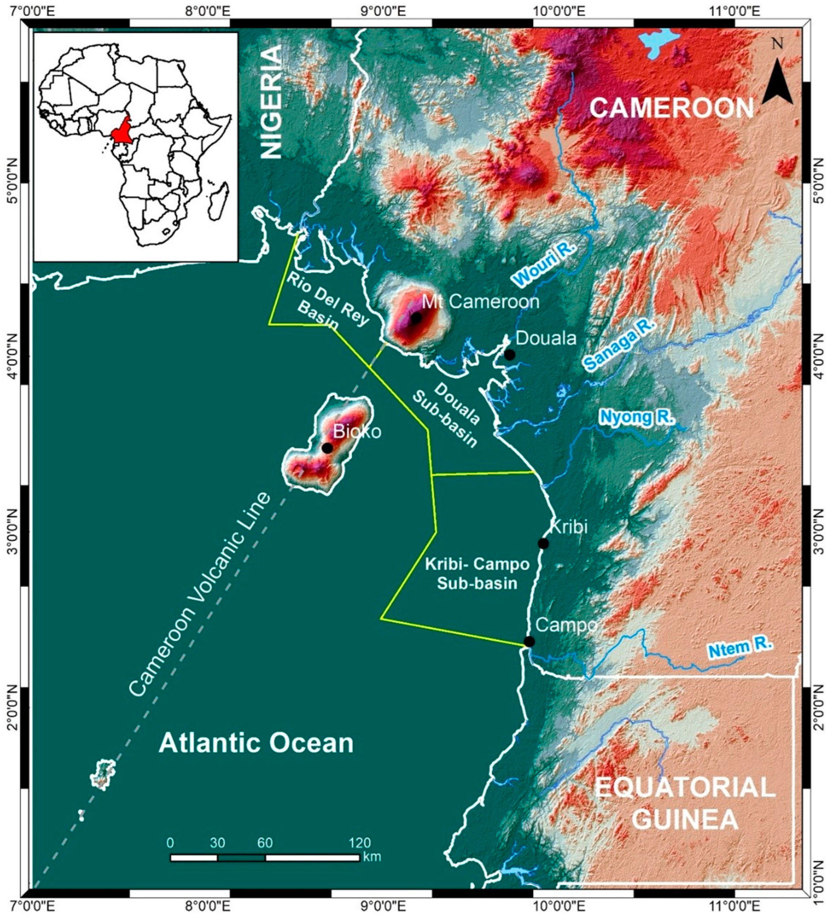
:1. Introduction
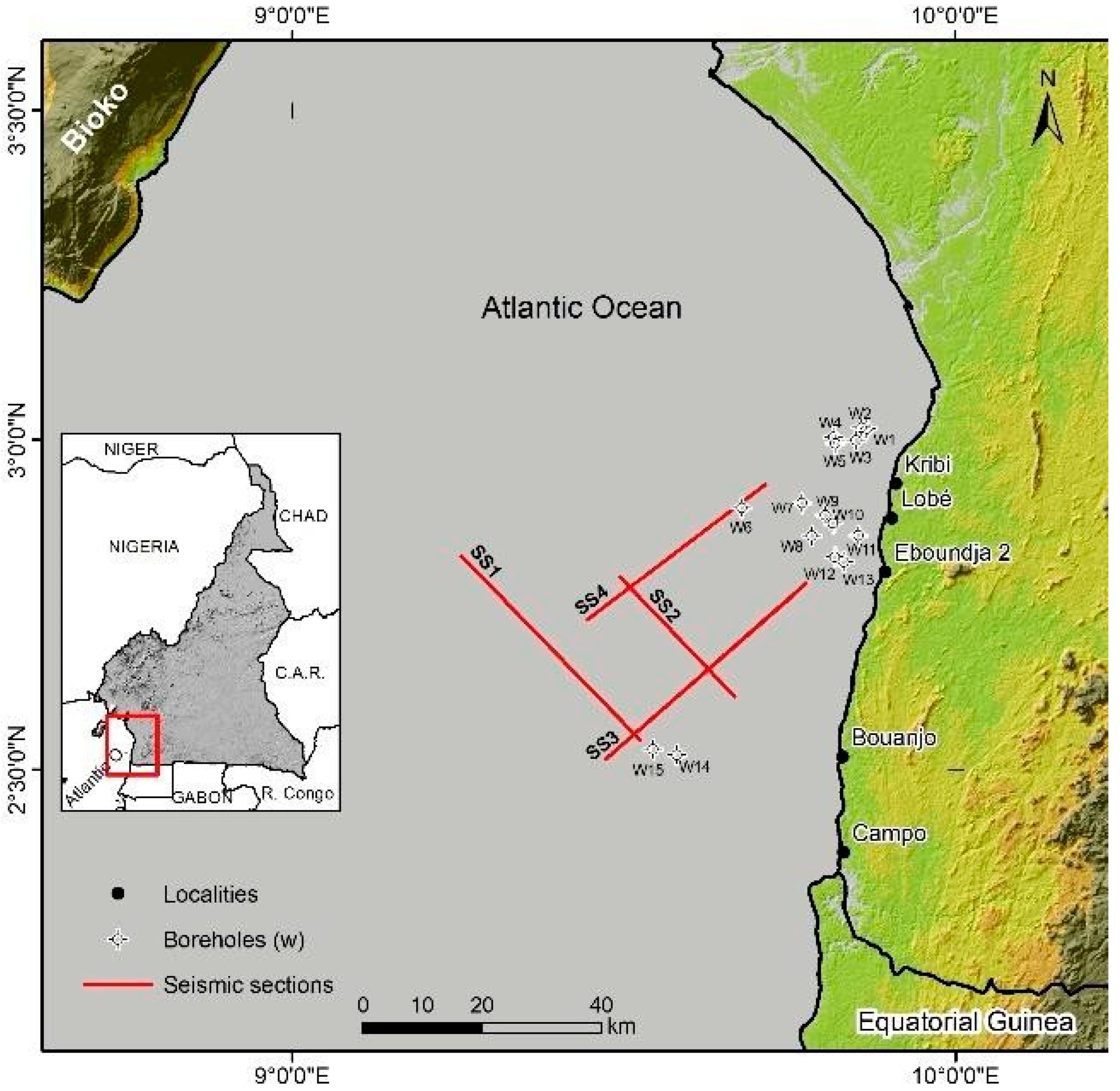
2. Materials and Methods
3. Results
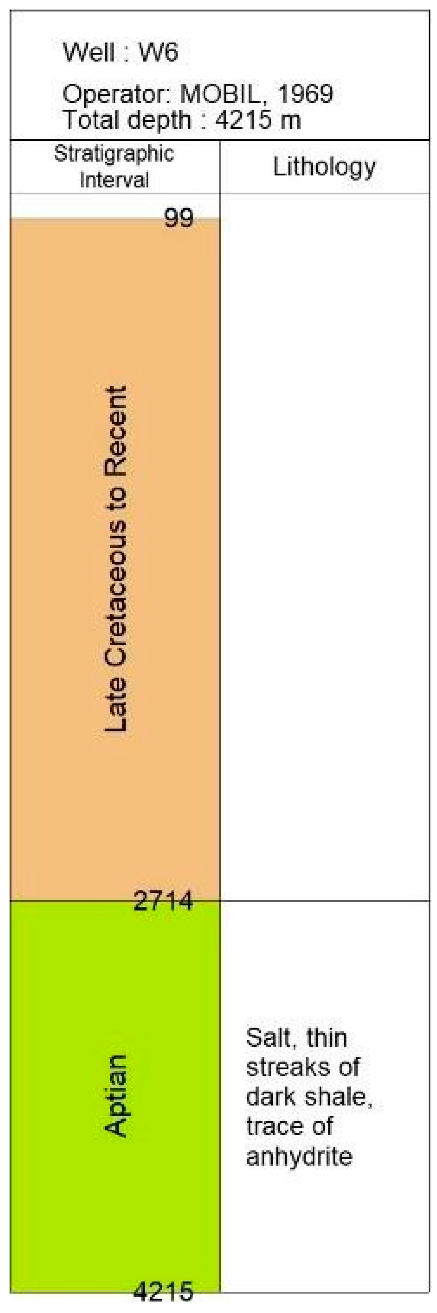
3.1. Borehole Data Analysis
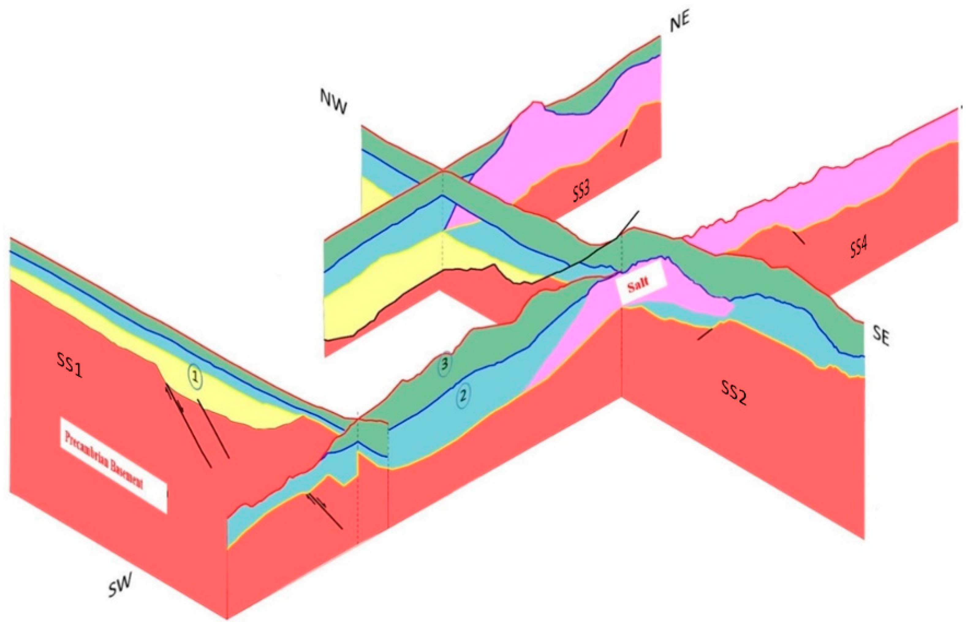
3.2. Seismic Analysis
3.2.1. Well to Seismic Tie
3.2.2. Seismic Data Analysis
4. Discussion
5. Conclusions
Author Contributions
Funding
Institutional Review Board Statement
Informed Consent Statement
Data Availability Statement
Acknowledgments
Conflicts of Interest
References
- Le, A.; Huuse, M.; Redfern, J.; Irving, D. Seismic Characterization of a Bottom Simulating Reflector (BSR) and Plumbing System of the Cameroon Margin, West Africa. Mar. Pet. Geol. 2015, 68, 629–647. [Google Scholar] [CrossRef]
- Phillips Inc. Geologic Development and Hydrocarbon Potential of the Douala Basin, Cameroon, Text and Figures; Phillips Inc.: Amsterdam, The Netherlands, 1990; p. 34. [Google Scholar]
- Pauken, R. Sanaga Sud Field, offshore Cameroon, West Africa. In Giant Oil and Gas Field of the Decade 1978–1988; Halbouty, M., Ed.; AAPG Memoir: Tulsa, OK, USA, 1992; pp. 217–230. [Google Scholar]
- Nguene, F.R.; Tamfu, S.F.; Loule, J.P.; Ngassa, C. Paleoenvironments of the Douala and Kribi/Campo sub basins, in Cameroon, West Africa. In Géologie Africaine: 1er Colloque de Stratigraphie Et de Paléogéographie Des Bassins Sédimentaires Ouest-Africains; 2e Colloque Africain de Micropaléontologie, Libreville, Gabon, 6–8 Mai 1991; Recueil Des Communications; Curnelle, R., Ed.; Elf Aquitaine: Courbevoie, France, 1992; pp. 129–139. [Google Scholar]
- Helm, C. Quantification des Flux Sédimentaires Anciens à L’échelle d’un Continent: Le cas de l’Afrique au Méso-Cénozoïque. Ph.D. Thesis, Université Rennes 1, Rennes, France, 2009; p. 299. [Google Scholar]
- Yem, M. Caractérisation par Imagerie Géophysique de la Couverture Sédimentaire des Bassins Offshores Profonds du Nord de la Cyrénaïque et de Douala/Kribi-Campo: Éléments de Géologie Pétrolière. Ph.D. Thesis, Université de Yaoundé I, Yaoundé, Cameroon, 2012; p. 143. [Google Scholar]
- Loule, J.P.; Jifon, F.; Angoua-Biouele, S.E.; Nguema, P.; Spofforth, D.; Carruthers, D.; Watkins, C.; Johnston, J. An opportunity to re-evaluate the petroleum potential of the Douala/Kribi-Campo Basin, Cameroon. Spec. Top. Pet. Geol. 2018, 36, 61–70. [Google Scholar] [CrossRef]
- Mienlam Essi, M.-F.; Yene Atangana, J.Q.; Abate Essi, J.M.; Yem, M.; Angoua Biouele, S.E.; Nguema, P.; Tsimi Ntsengue, C. Stratigraphical nature of the Top Albian surface, from seismic and wells data analyses, in the south Sanaga area (Cameroon Atlantic margin): Palaeogeographical significance and petroleum implications. Mar. Pet. Geol. 2021, 129, 105073. [Google Scholar] [CrossRef]
- Secke Beckonga Guott, B.; Yem, M.; Yene Atangana, J.Q.; Nkoa Nkoa, P.E.; Angoua Biouele, S.E.; Niyazi, Y.; Eruteya, E.O. Seismic geomorphology of a Late Cretaceous submarine channel system on the continental slope of Kribi/Campo sub-basin, offshore Cameroon. Mar. Pet. Geol. 2022, 145, 105865. [Google Scholar] [CrossRef]
- Pautot, G.; Renard, V.; Daniel, J.; Dupont, J. Morphology, limits, origin and age of salt layer along south Atlantic African margin. Am. Assoc. Pet. Geol. Bull. 1973, 57, 1658–1671. [Google Scholar]
- Benkhélil, J.; Giresse, P.; Poumot, C.; Ngueutchoua, G. Lithostratigraphic, geophysical and morpho-tectonic studies of the south Cameroon shelf. Mar. Pet. Geol. 2002, 19, 499–517. [Google Scholar] [CrossRef]
- SPT/Simon Petroleum Technology (Grapevine, TX, USA). Petroleum Geology and Hydrocarbon Potential of Douala Basin, Cameroon. Unpublished Report. 1995.
- Brownfield, M.E. Assessment of Undiscovered Oil and Gas Resources of the West-Central Coastal Province, West Africa; U.S.G.S.: Reston, VA, USA, 2016; p. 41. [Google Scholar]
- Davison, I. Geology and Tectonics of the South Atlantic Brazilian Salt Basin; Geological Society Special Publications: London, UK, 2007; pp. 345–359. [Google Scholar]
- Lawrence, S.R.; Munday, S.; Bray, R. Regional geology and geophysics of the eastern Gulf of Guinea (Niger Delta to Rio Muni). Lead. Edge 2002, 21, 1112–1117. [Google Scholar] [CrossRef]
- Mitchum, R.M.; Vail, P.R.; Sangree, J.B. Seismic stratigraphy and global changes of sea-level, Part 6: Stratigraphic interpretation of seismic reflection patterns in depositional sequences. In Seismic Stratigraphy-Applications to Hydrocarbon Exploration; Payton, C.E., Ed.; AAPG Mem.: Tulsa, OK, USA, 1977; pp. 117–133. [Google Scholar]
- Bernitsas, N.; Sun, J.; Sicking, C. Prism waves—An explanation for curved seismic horizons below the edge of salt bodies. In Proceedings of the 59th Annual International Conference and Exhibition EAGE, Extended Abstracts, Geneva, Switzerland, 26–30 May 1997; p. E38. [Google Scholar]
- Lafond, C.; Jones, I.F.; Bridson, M.; Houllevigue, H.; Kerdraon, Y.; Peliganga, J. Imaging deep water salt bodies in West Africa. Lead. Edge 2003, 22, 893–896. [Google Scholar] [CrossRef]
- Liu, Z.; Li, J. Control of salt structures on hydrocarbons in the passive continental margin of West Africa. Petrol. Explor. Develop. 2011, 38, 196–202. [Google Scholar] [CrossRef]
- Jones, I.F.; Davison, I. Seismic imaging in and around salt bodies. Special section: Salt basin model building, imaging, and interpretation. Interpretation 2014, 2, SL1–SL20. [Google Scholar] [CrossRef]


Disclaimer/Publisher’s Note: The statements, opinions and data contained in all publications are solely those of the individual author(s) and contributor(s) and not of MDPI and/or the editor(s). MDPI and/or the editor(s) disclaim responsibility for any injury to people or property resulting from any ideas, methods, instructions or products referred to in the content. |
© 2023 by the authors. Licensee MDPI, Basel, Switzerland. This article is an open access article distributed under the terms and conditions of the Creative Commons Attribution (CC BY) license (https://creativecommons.org/licenses/by/4.0/).
Share and Cite
Essi, M.-F.M.; Atangana, J.Q.Y.; Yem, M.; Biouele, S.E.A.; Lee, E.Y. Salt Units of the Kribi-Campo Sub-Basin Revisited, Using Offshore 2D Seismic and Boreholes Data: Depositional Context and Petroleum Implications. Proceedings 2023, 87, 2. https://doi.org/10.3390/IECG2022-14295
Essi M-FM, Atangana JQY, Yem M, Biouele SEA, Lee EY. Salt Units of the Kribi-Campo Sub-Basin Revisited, Using Offshore 2D Seismic and Boreholes Data: Depositional Context and Petroleum Implications. Proceedings. 2023; 87(1):2. https://doi.org/10.3390/IECG2022-14295
Chicago/Turabian StyleEssi, Mike-Franck Mienlam, Joseph Quentin Yene Atangana, Mbida Yem, Serge Edouard Angoua Biouele, and Eun Young Lee. 2023. "Salt Units of the Kribi-Campo Sub-Basin Revisited, Using Offshore 2D Seismic and Boreholes Data: Depositional Context and Petroleum Implications" Proceedings 87, no. 1: 2. https://doi.org/10.3390/IECG2022-14295