


Field Baseflow Eluting SOM-Rich Sandy Soil to Exacerbate Non-Point Source Pollution of Lake Erhai, Southwest China
Abstract
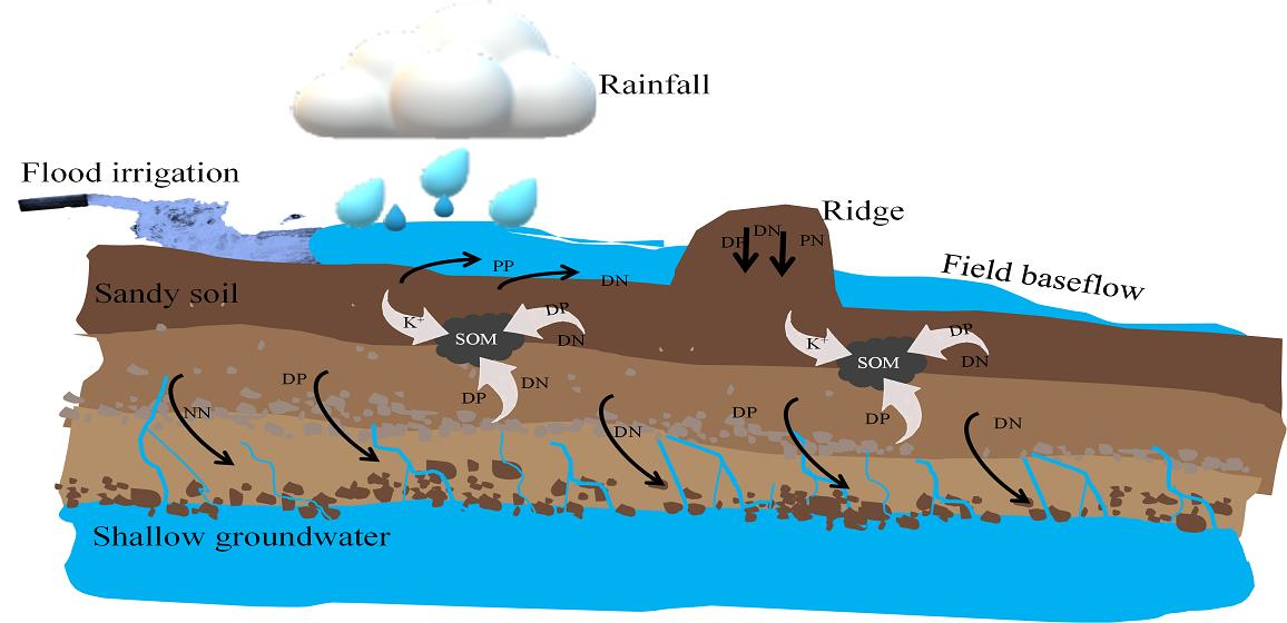
:
1. Introduction
2. Materials and Methods
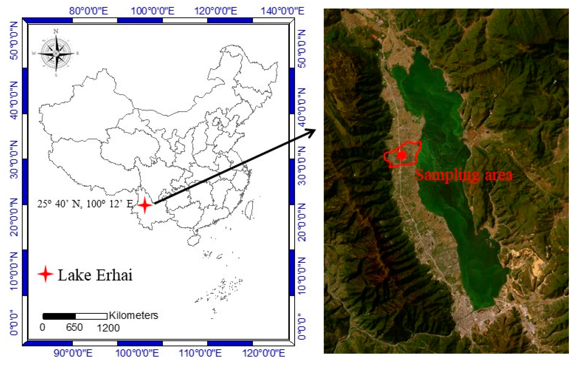
2.1. Study Area
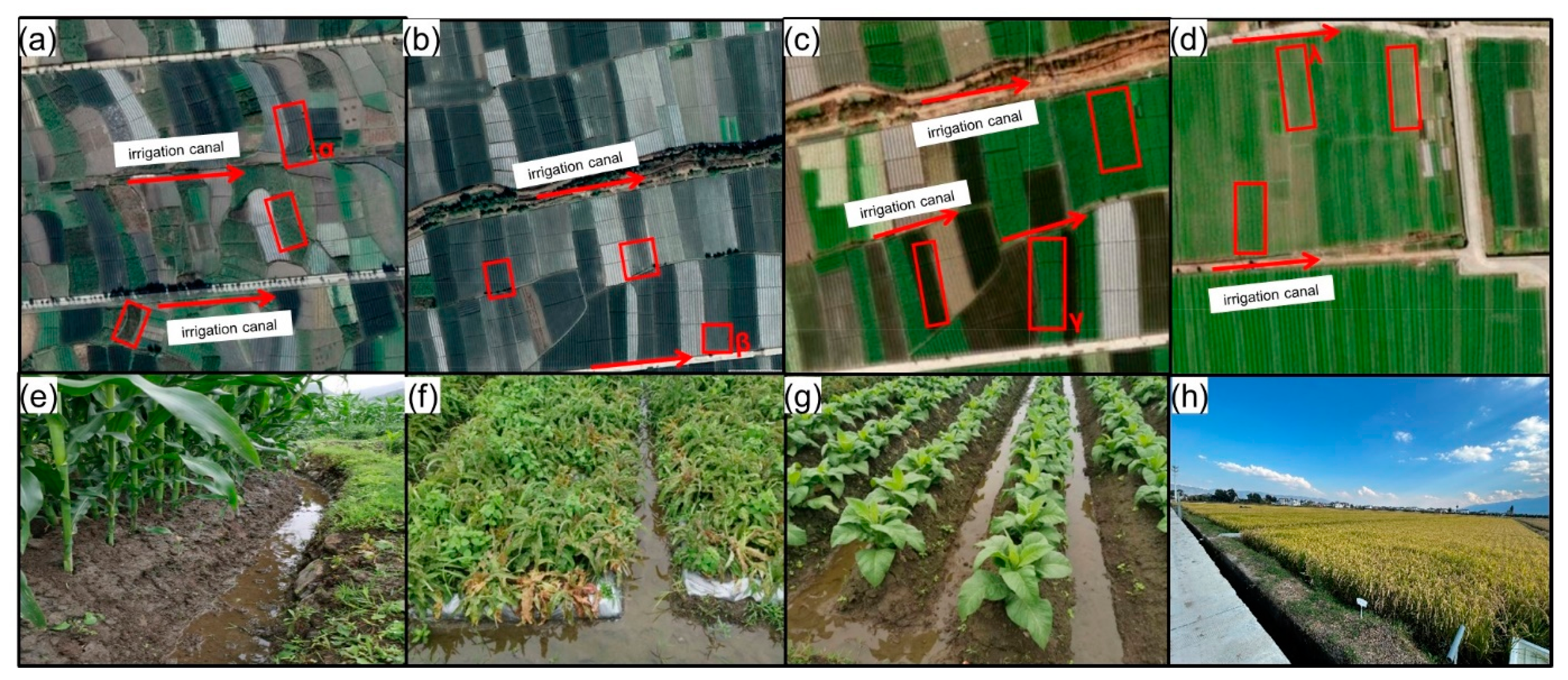
2.2. Methods
2.3. Measurements of Soil and Water Samples
2.4. Statistical Analysis
3. Results
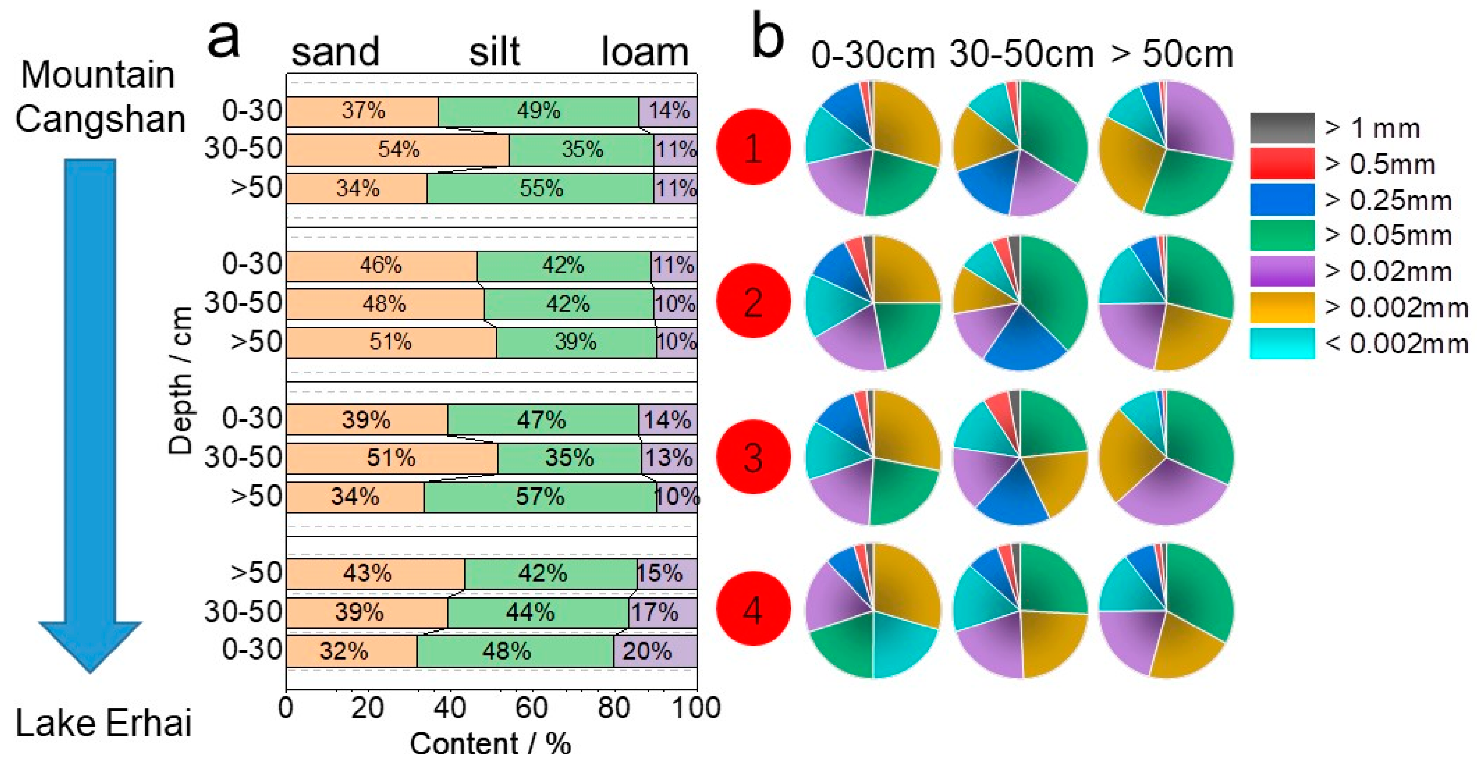
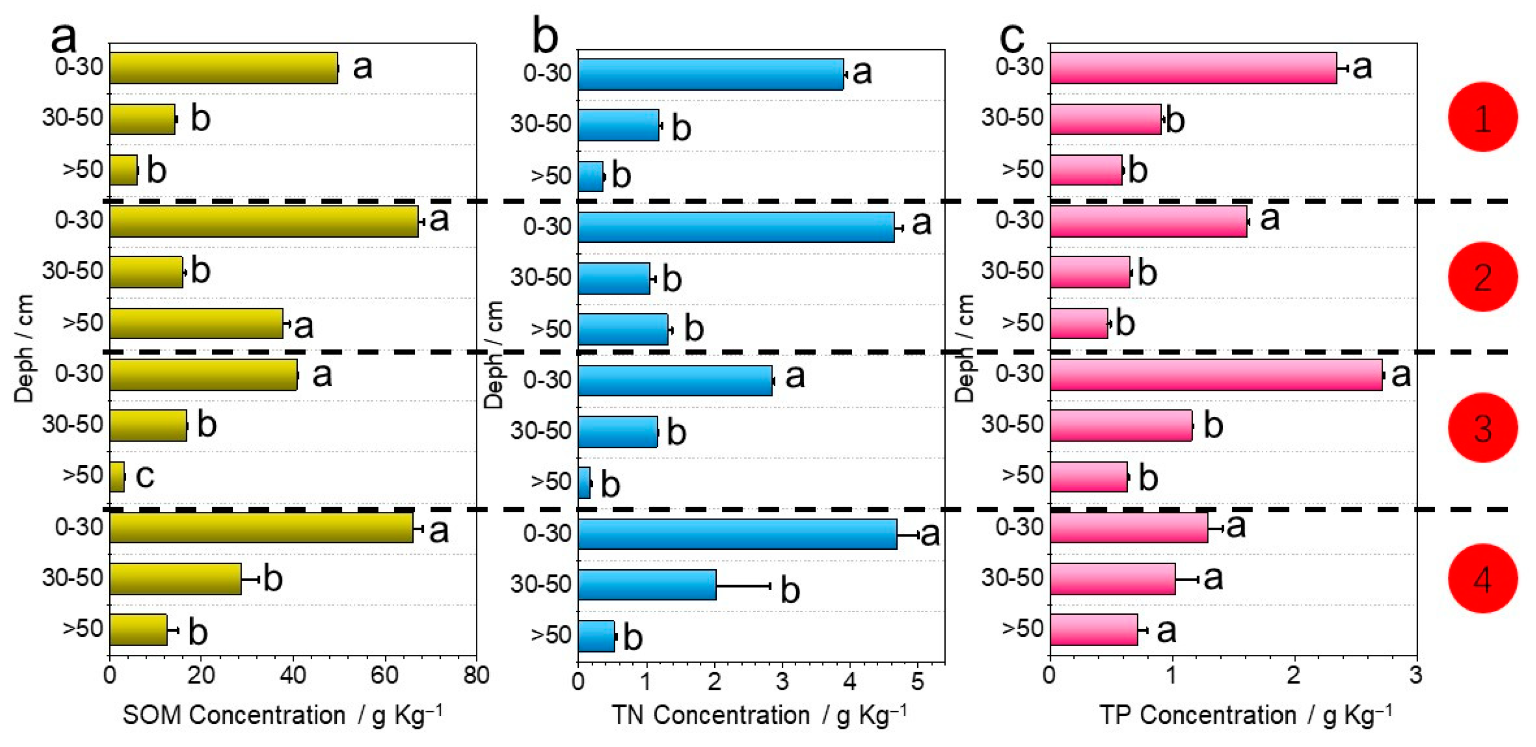
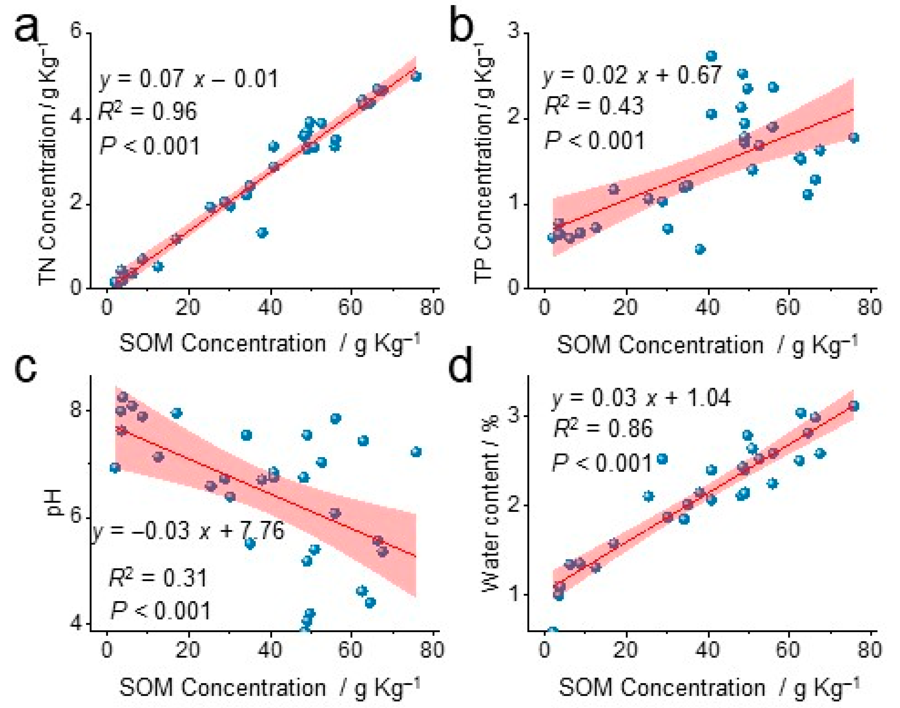
3.1. Spatial Distribution Characteristics of Soil Physicochemical Properties
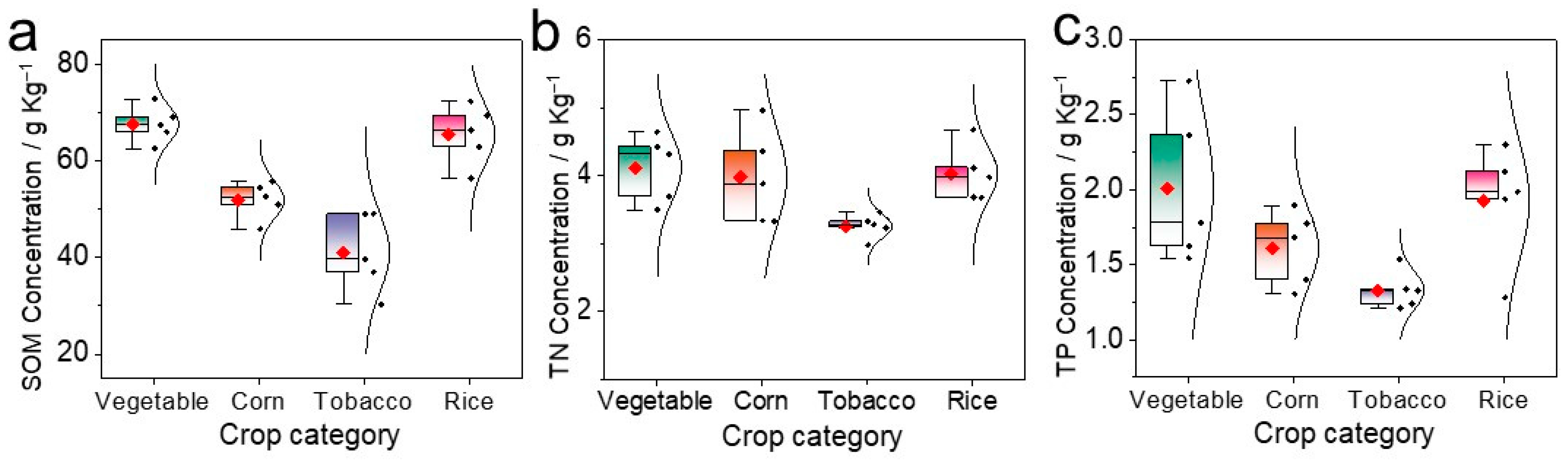
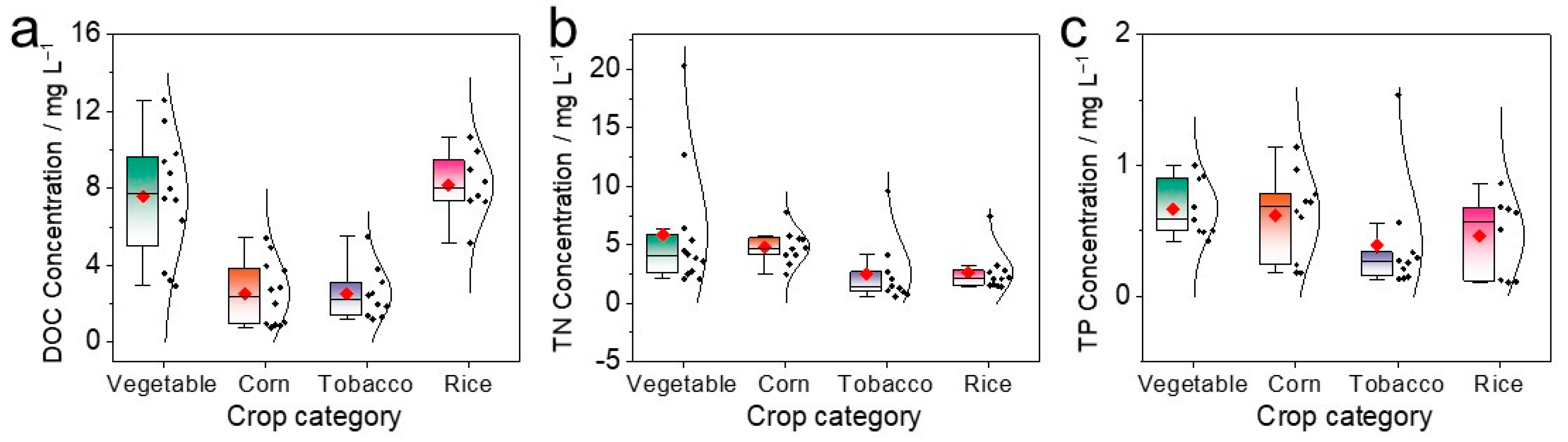
3.2. Nutrient Concentrations in Topsoil and Field Baseflow under Different Agricultural Management Measures
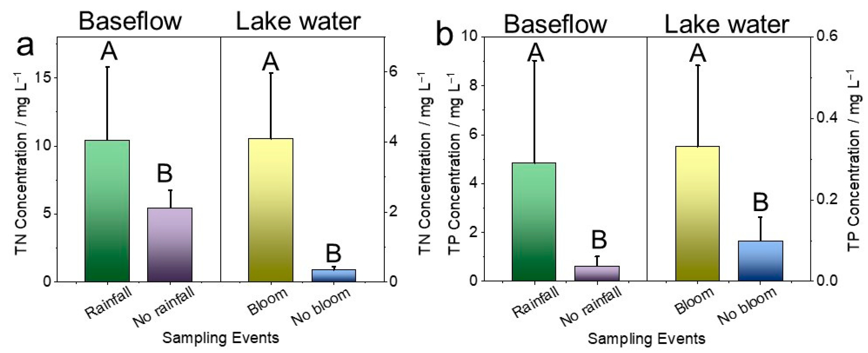
3.3. Nutrient Concentrations in Field Baseflow and Lake Erhai during Different Periods
4. Discussion
5. Conclusions
Supplementary Materials
Author Contributions
Funding
Data Availability Statement
Acknowledgments
Conflicts of Interest
References
- Li, X.-P.; Cai, J.; Wang, Q.-J.; Wang, X.-W. Heterogeneous public preferences for controlling agricultural non-point source pollution based on a choice experiment. J. Environ. Manag. 2022, 305, 114413. [Google Scholar] [CrossRef]
- Babin, N.; Mullendore, N.D.; Prokopy, L.S. Using social criteria to select watersheds for non-point source agricultural pollution abatement projects. Land Use Policy 2016, 55, 327–333. [Google Scholar] [CrossRef]
- Li, D.; Zheng, B.H.; Chu, Z.S.; Liu, Y.; Huang, M.S. Seasonal variations of performance and operation in field-scale storing multipond constructed wetlands for nonpoint source pollution mitigation in a plateau lake basin. Bioresour. Technol. 2019, 280, 295–302. [Google Scholar] [CrossRef]
- Dai, X.; Zhou, Y.; Ma, W.; Zhou, L. Influence of spatial variation in land-use patterns and topography on water quality of the rivers inflowing to Fuxian Lake, a large deep lake in the plateau of southwestern China. Ecol. Eng. 2017, 99, 417–428. [Google Scholar] [CrossRef]
- QuanLi, X.; Kun, Y.; GuiLin, W.; YuLian, Y. Agent-based modeling and simulations of land-use and land-cover change according to ant colony optimization: A case study of the Erhai Lake Basin, China. Nat. Hazard. 2015, 75, 95–118. [Google Scholar] [CrossRef]
- Xiang, S.; Wu, Y.; Lu, X.; Gao, S.; Chu, Z.; Pang, Y. Characteristics and spatial distribution of agricultural non-point source pollution in Erhai Lake basin and its classified control strategy. Res. Environ. Sci. 2020, 33, 2474–2483. [Google Scholar]
- Li, C.; Shi, W.; Huang, M. Effects of crop rotation and topography on soil erosion and nutrient loss under natural rainfall conditions on the Chinese Loess Plateau. Land 2023, 12, 265. [Google Scholar] [CrossRef]
- Dunne, E.J.; Reddy, K.R.; Clark, M.W. Phosphorus release and retention by soils of natural isolated wetlands. Int. J. Environ. Pollut. 2006, 28, 496–516. [Google Scholar] [CrossRef] [Green Version]
- Yang, J.; Ma, Y.; Li, S.; Wang, J.; Jin, Z.; Li, D.; Wang, Y. Phosphorus release flux and mechanism at the sediment–water interface of the Three Gorges Reservoir in the Yangtze River basin, China. J. Soils Sediments, 2023; ahead of print. [Google Scholar] [CrossRef]
- Gill, J.S.; Sivasithamparam, K.; Smettem, K.R.J. Soil types with different texture affects development of Rhizoctonia root rot of wheat seedlings. Plant Soil 2000, 221, 113–120. [Google Scholar] [CrossRef]
- Veisi, H.; Carolan, M.S.; Alipour, A.; Besheh, A.V. Competing fields in sustainable agriculture: On farmer-expert understandings of good farming, good farmers and organic farming. Int. J. Agric. Sustain. 2022, 20, 289–301. [Google Scholar] [CrossRef]
- Burakova, A.; Bakšiene, E. Leaching losses of main nutrients by incorporating organic fertilisers into light texture soils Haplic Luvisol. Environ. Eng. Res. 2021, 26, 200190. [Google Scholar] [CrossRef]
- Ahmed, A.I.A.; Eldoma, I.M.; Elaagip, E.E.A.H.; Hou, F. Effects of Indigenous cultivation practices on soil conservation in the Hilly Semiarid Areas of Western Sudan. Water 2020, 12, 1554. [Google Scholar] [CrossRef]
- Shrestha, R.K.; Cooperband, L.R.; MacGuidwin, A.E. Strategies to reduce nitrate leaching into groundwater in potato grown in sandy soils: Case study from north central USA. Am. J. Potato Res. 2010, 87, 229–244. [Google Scholar] [CrossRef]
- Wu, D.; Li, M.; Du, L.; Ren, D.; Wang, J. Straw return in paddy field alters photodegradation of organic contaminants by changing the quantity rather than the quality of water-soluble soil organic matter. Sci. Total Environ. 2022, 821, 153371. [Google Scholar] [CrossRef] [PubMed]
- Wang, H.; Xu, J.; Liu, X.; Zhang, D.; Li, L.; Li, W.; Sheng, L. Effects of long-term application of organic fertilizer on improving organic matter content and retarding acidity in red soil from China. Soil Tillage Res. 2019, 195, 104382. [Google Scholar] [CrossRef]
- Yi, B.; Zhang, Q.; Gu, C.; Li, J.; Abbas, T.; Di, H. Effects of different fertilization regimes on nitrogen and phosphorus losses by surface runoff and bacterial community in a vegetable soil. J. Soils Sediments 2018, 18, 3186–3196. [Google Scholar] [CrossRef]
- Lentz, R.D.; Westermann, D.T. Managing runoff water quality from recently manured, furrow-irrigated fields. Soil Sci. Soc. Am. J. 2010, 74, 1310–1319. [Google Scholar] [CrossRef]
- Xu, A.; Yang, L.E.; Yang, W.; Chen, H. Water conservancy projects enhanced local resilience to floods and droughts over the past 300 years at the Erhai Lake basin, Southwest China. Environ. Res. Lett. 2020, 15, 125009. [Google Scholar] [CrossRef]
- Claes, N.; Paige, G.B.; Parsekian, A.D. Uniform and lateral preferential flows under flood irrigation at field scale. Hydrol. Process. 2019, 33, 2131–2147. [Google Scholar] [CrossRef]
- Ru, X.; Jingnan, C.; Zhiyuan, L.; Xieyong, C.; Maomao, H.; Shanshan, S.; Qiu, J.; Fenglin, Z. Fate of urea-15N as influenced by different irrigation modes. RSC Adv. 2020, 10, 11317–11324. [Google Scholar] [CrossRef]
- Wang, W.; Chen, Y.; Wang, W.; Zhu, C.; Chen, Y.; Liu, X.; Zhang, T. Water quality and interaction between groundwater and surface water impacted by agricultural activities in an oasis-desert region. J. Hydrol. 2023, 617, 128937. [Google Scholar] [CrossRef]
- Korolev, V.A. Changes in the main physical properties of ordinary chernozems under the impact of irrigation. Eurasian Soil Sci. 2008, 41, 1092–1097. [Google Scholar] [CrossRef]
- Zou, L.; Zhao, P.; Li, S.; Dai, M.; Jiang, Y.; Wang, L.; Tian, M.; Yang, Z.; Li, S.; Wang, J. Research on difference in pH, CEC, texture of soils surrounding alpine lakes in Yunnan Province. Southwest China J. Agric. Sci. 2019, 32, 1626–1632. [Google Scholar]
- Guo, Y.; Chen, Y.; Miao, Q.; Fan, Z.; Sun, J.; Cui, Z.; Li, J. Spatial-temporal variability of soil nutrients and assessment of soil fertility in Erhai Lake basin. Sci. Agric. Sin. 2022, 55, 1987–1999. [Google Scholar]
- Tao, W.; Bo, Z.; Fuhong, K. Reducing interflow nitrogen loss from hillslope cropland in a purple soil hilly region in southwestern China. Nutr. Cycl. Agroecosyst. 2012, 93, 285–295. [Google Scholar] [CrossRef]
- Xiao, Q.; Dong, Z.; Han, Y.; Hu, L.; Hu, D.; Zhu, B. Impact of soil thickness on productivity and nitrate leaching from sloping cropland in the upper Yangtze River Basin. Agric. Ecosyst. Environ. 2021, 311, 107266. [Google Scholar] [CrossRef]
- Zhang, D.; Fan, M.; Liu, H.; Wang, R.; Zhao, J.; Yang, Y.; Cui, R.; Chen, A. Effects of shallow groundwater table fluctuations on nitrogen in the groundwater and soil profile in the nearshore vegetable fields of Erhai Lake, southwest China. J. Soils Sediments 2020, 20, 42–51. [Google Scholar] [CrossRef]
- Li, J.; Hou, L.; Wang, Y.; Duan, X.; Chen, M.; Liang, Q. Effects of fertilizer application rates on soil nitrogen leaching of typical farmland in Luoshijiang River sub-basin from Erhai Lake. Environ. Sci. Technol. 2022, 45, 147–155. [Google Scholar]
- Liang, Q.; Li, R.; Li, J.; Hou, L.; Wang, Y. Stoichiometric characteristics of soil carbon, nitrogen and phosphorus in the forestland-farmland-riparian zone of Luoshijiang small watershed in Erhai basin. Southwest China J. Agric. Sci. 2022, 35, 2587–2594. [Google Scholar]
- Chen, A.; Lei, B.; Liu, H.; Zhai, L.; Wang, H.; Mao, Y.; Zhang, D. Adsorption and desorption of NH4+-N in the different soil genesis layers in the nearshore vegetable field of Erhai Lake. J. Agro Environ. Sci. 2017, 36, 345–352. [Google Scholar]
- Shen, J.; Liu, H.; Hu, W.; Zhai, L.; Lei, B. Effects of different agronomic techniques on soil organic matter fractions and risk of nitrogen leaching. Southwest China J. Agric. Sci. 2013, 26, 1578–1584. [Google Scholar]
- Lobe, I.; Amelung, W.; Du Preez, C.C. Losses of carbon and nitrogen with prolonged arable cropping from sandy soils of the South African Highveld. Eur. J. Soil Sci. 2001, 52, 93–101. [Google Scholar] [CrossRef]
- Latifah, O.; Ahmed, O.H.; Abdul Majid, N.M. Enhancing nitrogen availability, ammonium adsorption-desorption, and soil pH buffering capacity using composted paddy husk. Eurasian Soil Sci. 2017, 50, 1483–1493. [Google Scholar] [CrossRef]
- Gao, Y.; Fang, Z.; Van Zwieten, L.; Bolan, N.; Dong, D.; Quin, B.F.; Meng, J.; Li, F.; Wu, F.; Wang, H.; et al. A critical review of biochar-based nitrogen fertilizers and their effects on crop production and the environment. Biochar 2022, 4, 36. [Google Scholar] [CrossRef]
- Cao, X.; Ma, L.Q.; Singh, S.P.; Zhou, Q. Phosphate-induced lead immobilization from different lead minerals in soils under varying pH conditions. Environ. Pollut. 2008, 152, 184–192. [Google Scholar] [CrossRef]
- Tang, Z.; Zhang, W.; Chen, Y. Adsorption and desorption characteristics of monosulfuron in Chinese soils. J. Hazard. Mater. 2009, 166, 1351–1356. [Google Scholar] [CrossRef]
- Xu, Z.; Qu, M.; Liu, S.; Duan, Y.; Wang, X.; Brown, L.K.; George, T.S.; Zhang, L.; Feng, G. Carbon addition reduces labile soil phosphorus by increasing microbial biomass phosphorus in intensive agricultural systems. Soil Use Manag. 2020, 36, 536–546. [Google Scholar] [CrossRef]
- Liu, K.-L.; Han, T.-F.; Huang, J.; Asad, S.; Li, D.-M.; Yu, X.-C.; Huang, Q.-H.; Ye, H.-C.; Hu, H.-W.; Hu, Z.-H.; et al. Links between potassium of soil aggregates and pH levels in acidic soils under long-term fertilization regimes. Soil Tillage Res. 2020, 197, 104480. [Google Scholar] [CrossRef]
- Bogunovic, I.; Mesic, M.; Zgorelec, Z.; Jurisic, A.; Bilandzija, D. Spatial variation of soil nutrients on sandy-loam soil. Soil Tillage Res. 2014, 144, 174–183. [Google Scholar] [CrossRef]
- Eltohamy, K.M.; Liu, C.; Khan, S.; Niyungeko, C.; Jin, Y.; Hosseini, S.H.; Li, F.; Liang, X. An internet-based smart irrigation approach for limiting phosphorus release from organic fertilizer-amended paddy soil. J. Clean. Prod. 2021, 293, 126254. [Google Scholar] [CrossRef]
- Lv, H.; Zhou, W.; Dong, J.; He, S.; Chen, F.; Bi, M.; Wang, Q.; Li, J.; Liang, B. Irrigation amount dominates soil mineral nitrogen leaching in plastic shed vegetable production systems. Agric. Ecosyst. Environ. 2021, 317, 107474. [Google Scholar] [CrossRef]
- Bockheim, J.G.; Hartemink, A.E.; Huang, J. Distribution and properties of sandy soils in the conterminous USA—A conceptual thickness model, and taxonomic analysis. CATENA 2020, 195, 104746. [Google Scholar] [CrossRef]
- Cui, R.; Zhang, D.; Liu, G.; Wang, P.; Chen, A.; Wang, H. Shift of lakeshore cropland to buffer zones greatly reduced nitrogen loss from the soil profile caused by the interaction of lake water and shallow groundwater. Sci. Total Environ. 2022, 803, 149879. [Google Scholar] [CrossRef] [PubMed]
- Xia, L.; Liu, G.; Ma, L.; Yang, L.; Li, Y. The effects of contour hedges and reduced tillage with ridge furrow cultivation on nitrogen and phosphorus losses from sloping arable land. J. Soils Sediments 2014, 14, 462–470. [Google Scholar] [CrossRef]
- Li, K.-W.; Lu, H.-L.; Nkoh, J.N.; Hong, Z.-N.; Xu, R.-K. Aluminum mobilization as influenced by soil organic matter during soil and mineral acidification: A constant pH study. Geoderma 2022, 418, 115853. [Google Scholar] [CrossRef]
- Liu, Y.; Cui, Z.; Huang, Z.; Miao, H.T.; Wu, G.L. The influence of litter crusts on soil properties and hydrological processes in a sandy ecosystem. Hydrol. Earth Syst. Sci. 2019, 23, 2481–2490. [Google Scholar] [CrossRef] [Green Version]
- Abdi, E.; Babapour, S.; Majnounian, B.; Amiri, G.Z.; Deljouei, A. How does organic matter affect the physical and mechanical properties of forest soil? J. For. Res. 2018, 29, 657–662. [Google Scholar] [CrossRef]


| References | Crop Types | Sand/% | Silt/% | Loam/% | SOM/g kg−1 |
|---|---|---|---|---|---|
| [24] | -- | 35.86 | 49.31 | 15.17 | -- |
| [28] | vegetable | 35.02 | 56.89 | 8.09 | 59.87 |
| [29] | Rice | 33.73 | 45.87 | 20.4 | -- |
| Corn | 53.49 | 35.34 | 11.17 | -- | |
| Tobacco | 29.92 | 56.32 | 13.76 | -- | |
| [30] | -- | 43.45 | 43.71 | 12.84 | 74.86 |
| 60.62 | 31.35 | 8.02 | 33.14 | ||
| [31] | Vegetable | 34.91 | 56.76 | 8.33 | 60.36 |
| [32] | Garlic | 76.53 | 13.06 | 10.41 | 42.61 |
| Serial Number | Crop Types | Cropping Pattern | Irrigation Method | Planting Season/yr | Fertilization | |||
|---|---|---|---|---|---|---|---|---|
| Categories | Net Quantities/kg ha−1 Season | |||||||
| N | P2O5 | K2O | ||||||
| 1 | Corn | Ridge tillage | F | 4 | O/C | 276 b | 97 b | 83 b |
| 2 | Vegetable | Ridge tillage | F | 5 | O | 433 a | 273 a | 498 a |
| 3 | Tobacco | Ridge tillage | F | 2 | C | 46 d | 46 d | 58 c |
| 4 | Rice | -- | F | 2 | O | 200 c | 72 c | 90 b |
Disclaimer/Publisher’s Note: The statements, opinions and data contained in all publications are solely those of the individual author(s) and contributor(s) and not of MDPI and/or the editor(s). MDPI and/or the editor(s) disclaim responsibility for any injury to people or property resulting from any ideas, methods, instructions or products referred to in the content. |
© 2023 by the authors. Licensee MDPI, Basel, Switzerland. This article is an open access article distributed under the terms and conditions of the Creative Commons Attribution (CC BY) license (https://creativecommons.org/licenses/by/4.0/).
Share and Cite
He, D.; Liu, X.; Fu, Y.; Wang, T.; Zhu, B. Field Baseflow Eluting SOM-Rich Sandy Soil to Exacerbate Non-Point Source Pollution of Lake Erhai, Southwest China. Horticulturae 2023, 9, 898. https://doi.org/10.3390/horticulturae9080898
He D, Liu X, Fu Y, Wang T, Zhu B. Field Baseflow Eluting SOM-Rich Sandy Soil to Exacerbate Non-Point Source Pollution of Lake Erhai, Southwest China. Horticulturae. 2023; 9(8):898. https://doi.org/10.3390/horticulturae9080898
Chicago/Turabian StyleHe, Debo, Xianglong Liu, Yan Fu, Tao Wang, and Bo Zhu. 2023. "Field Baseflow Eluting SOM-Rich Sandy Soil to Exacerbate Non-Point Source Pollution of Lake Erhai, Southwest China" Horticulturae 9, no. 8: 898. https://doi.org/10.3390/horticulturae9080898