A New Multi-Temporal Forest Cover Classification for the Xingu River Basin, Brazil


Abstract
:Abstract
Dataset
Dataset license
1. Summary
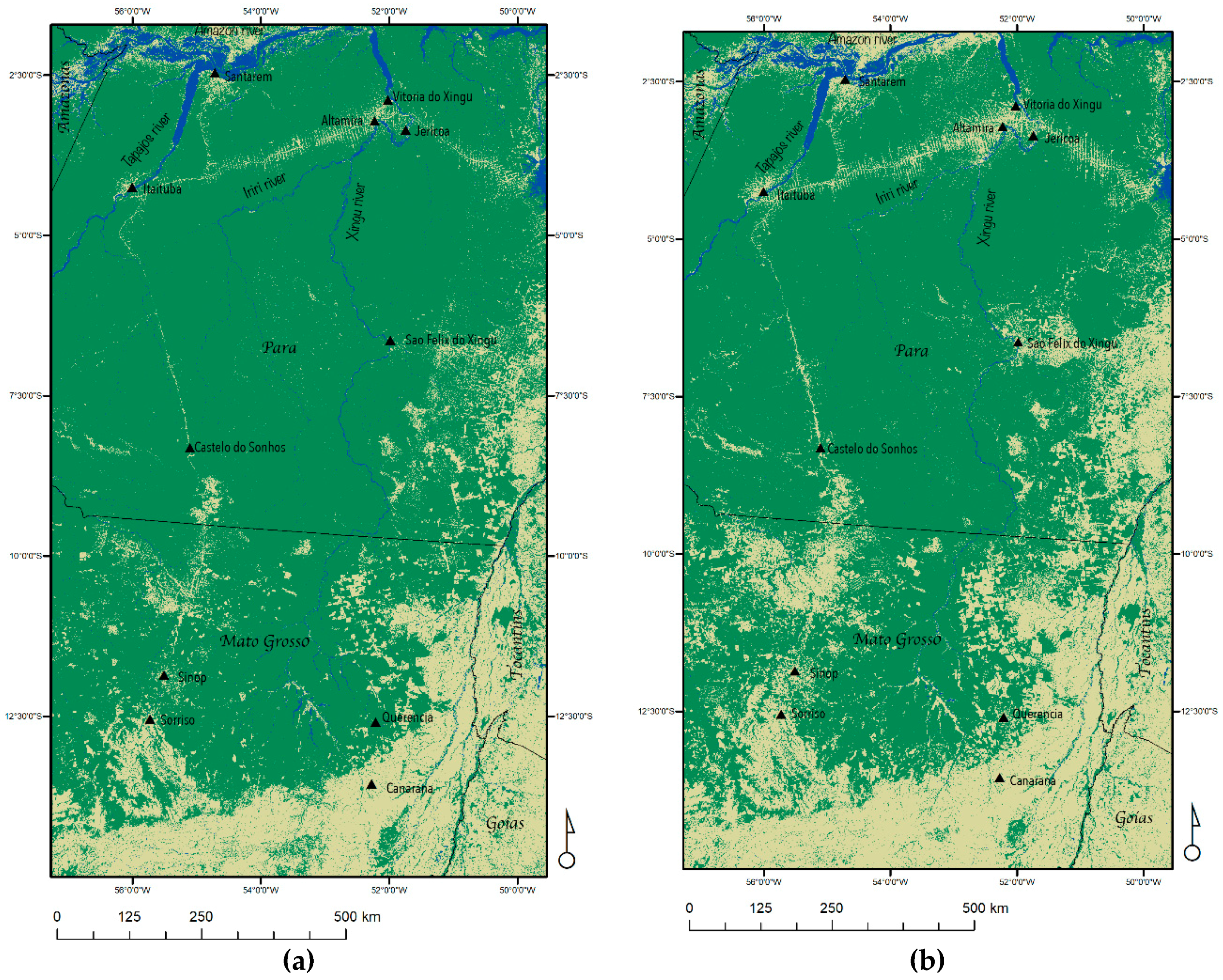
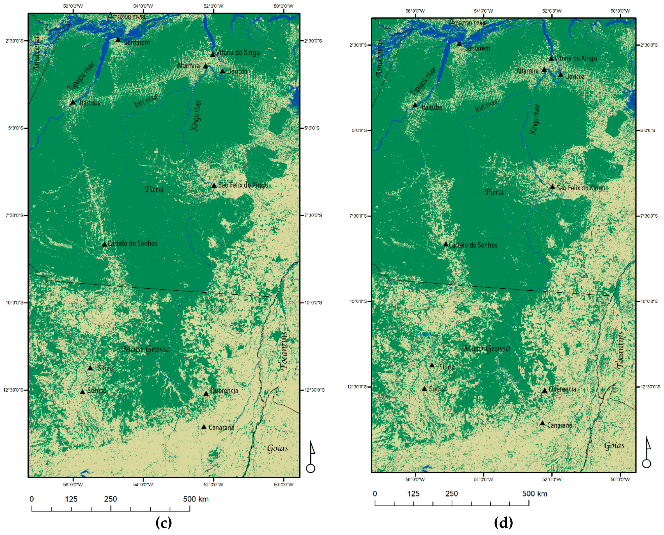
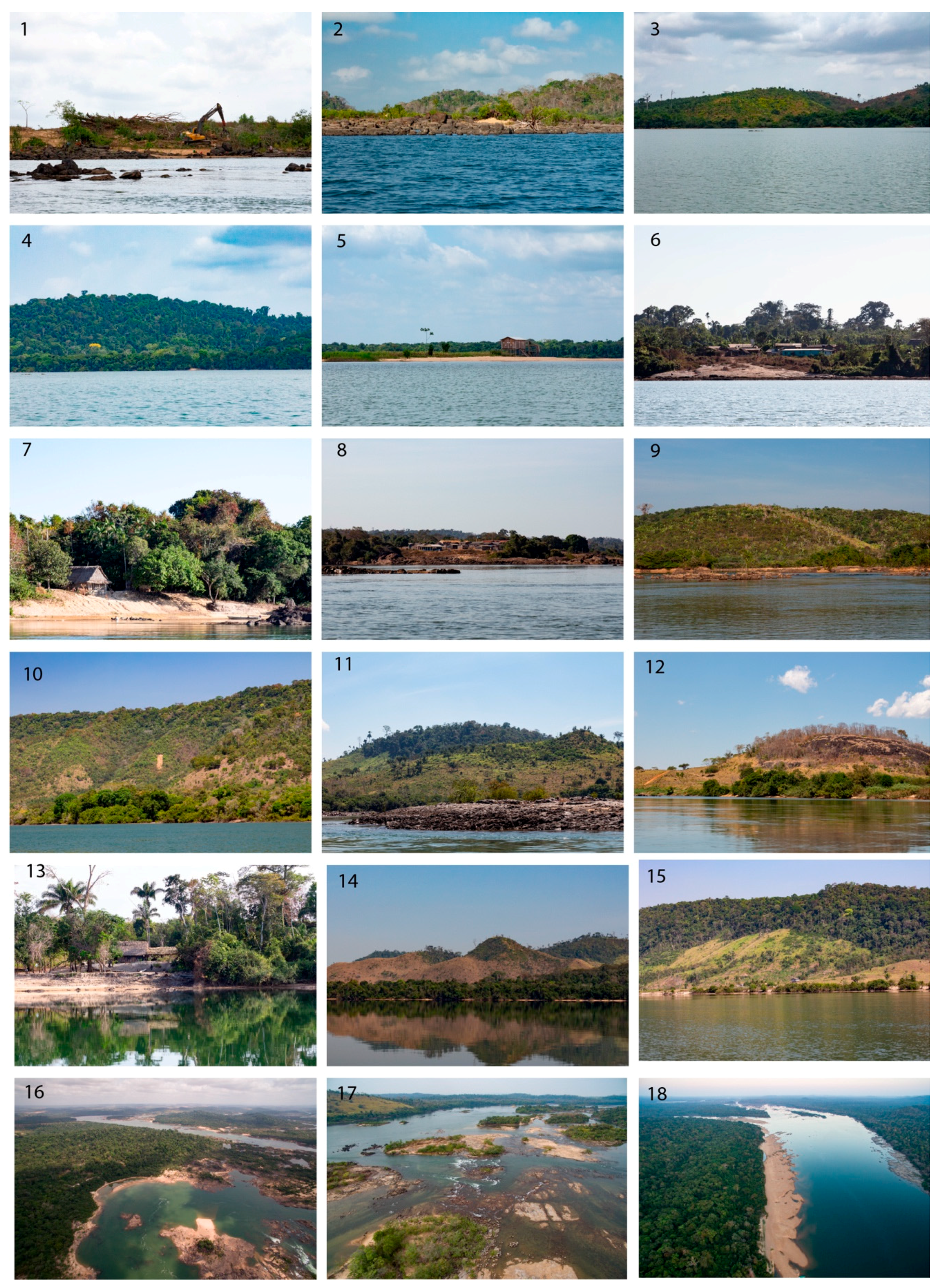
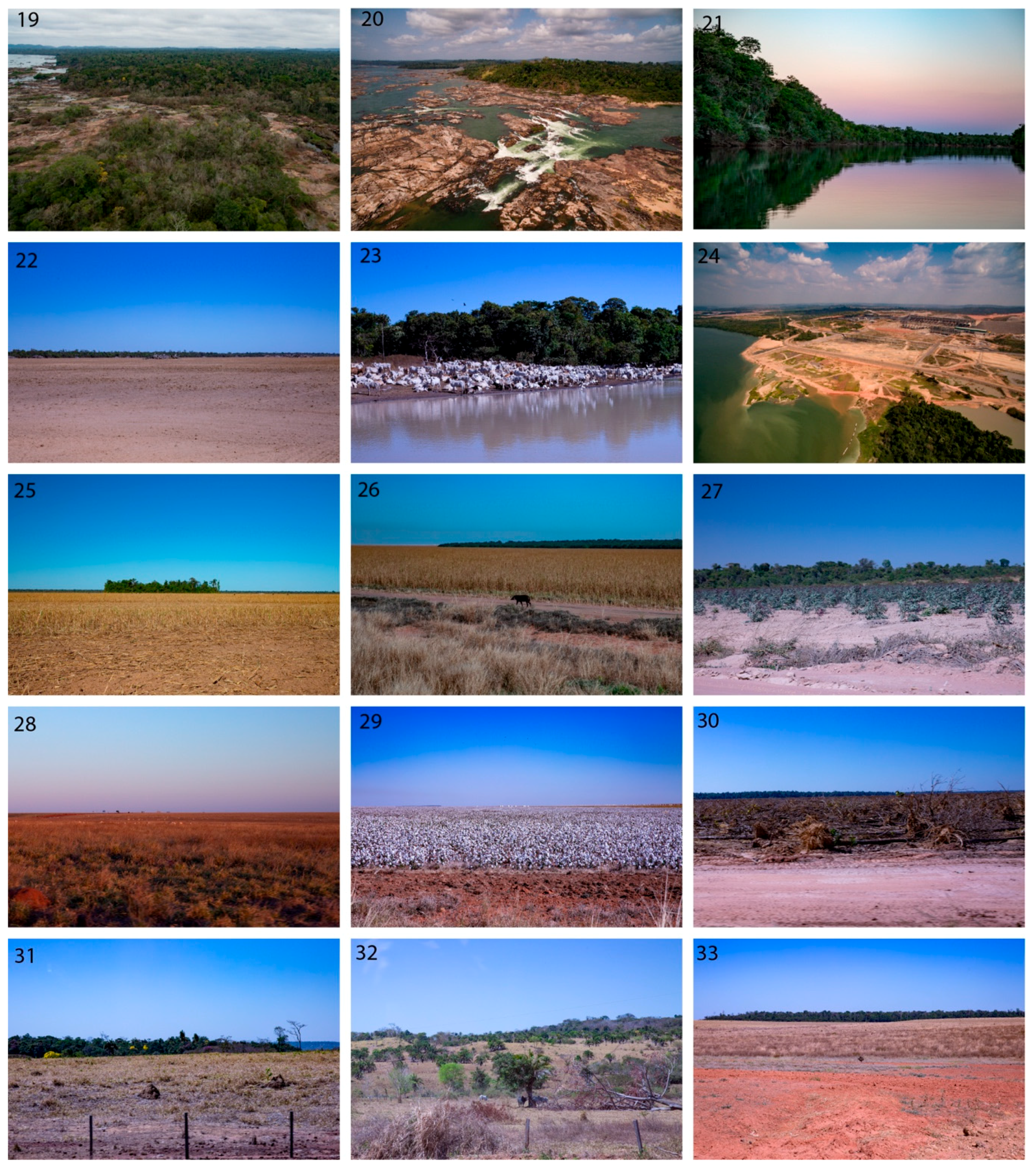
2. Data Description
3. Methods
4. Limitations
5. Conclusions
Author Contributions
Funding
Acknowledgments
Conflicts of Interest
References
- Dale, V.H.; Pearson, S.M.; Offerman, H.L.; Oneill, R.V. Relating patterns of land-use change to faunal biodiversity in the Central Amazon. Conserv. Biol. 1994, 8, 1027–1036. [Google Scholar] [CrossRef]
- Turner, I.M. Species loss in fragments of tropical rain forest: A review of the evidence. J. Appl. Ecol. 1996, 33, 200–209. [Google Scholar] [CrossRef]
- Westman, W.E.; Strong, L.L.; Wilcox, B.A. Tropical deforestation and species endangerment: The role of remote sensing. Landsc. Ecol. 1989, 3, 97–109. [Google Scholar] [CrossRef]
- Pimm, S.L. The dodo went extinct (and other ecological myths). Ann. Mo. Bot. Gard. 2002, 89, 190–198. [Google Scholar] [CrossRef]
- De Almeida, C.A.; Coutinho, A.C.; Esquerdo, J.C.D.; Adami, M.; Venturieri, A.; Diniz, C.G.; Dessay, N.; Durieux, L.; Gomes, A.R. High spatial resolution land use and land cover mapping of the Brazilian Legal Amazon in 2008 using Landsat-5/TM and MODIS data. Acta Amaz. 2016, 46, 291–302. [Google Scholar] [CrossRef]
- DeFries, R.S.; Townshend, J.R.G.; Hansen, M.C. Continuous fields of vegetation characteristics at the global scale at 1-km resolution. J. Geophys. Res. Atmos. 1999, 104, 16911–16923. [Google Scholar] [CrossRef]
- Hansen, M.C.; Potapov, P.V.; Moore, R.; Hancher, M.; Turubanova, S.A.; Tyukavina, A.; Thau, D.; Stehman, S.V.; Goetz, S.J.; Loveland, T.R.; et al. High-Resolution Global Maps of 21st-Century Forest Cover Change. Science 2013, 342, 850–853. [Google Scholar] [CrossRef] [PubMed] [Green Version]
- Shimada, M.; Itoh, T.; Motooka, T.; Watanabe, M.; Shiraishi, T.; Thapa, R.; Lucas, R. New global forest/non-forest maps from ALOS PALSAR data (2007–2010). Remote Sens. Environ. 2014, 155, 13–31. [Google Scholar] [CrossRef]
- Malhi, Y.; Roberts, J.T.; Betts, R.A.; Killeen, T.J.; Li, W.H.; Nobre, C.A. Climate change, deforestation, and the fate of the Amazon. Science 2008, 319, 169–172. [Google Scholar] [CrossRef] [PubMed]
- Pereira, J.C.; Viola, E. Catastrophic Climate Risk and Brazilian Amazonian Politics and Policies: A New Research Agenda. Glob. Environ. Politics 2019, 19, 93–103. [Google Scholar] [CrossRef]
- Barbosa, T.A.P.; Benone, N.L.; Begot, T.O.R.; Goncalves, A.; Sousa, L.; Giarrizzo, T.; Juen, L.; Montag, L.F.A. Effect of waterfalls and the flood pulse on the structure of fish assemblages of the middle Xingu River in the eastern Amazon basin. Braz. J. Biol. 2015, 75, S78–S94. [Google Scholar] [CrossRef] [PubMed]
- Camargo, M.; Giarrizzo, T.; Isaac, V. Review of the geographic distribution of fish fauna of the Xingu river basin, Brazil. Ecotropica 2004, 10, 123–147. [Google Scholar]
- Dagosta, F.C.P.; De Pinna, M. The fishes of the Amazon: Distribution and biogeographical patterns, with a comprehensive list of species. Bull. Am. Mus. Nat. Hist. 2019, 431, 163. [Google Scholar] [CrossRef]
- Fitzgerald, D.B.; Perez, M.H.S.; Sousa, L.M.; Goncalves, A.P.; Py-Daniel, L.R.; Lujan, N.K.; Zuanon, J.; Winemiller, K.O.; Lundberg, J.G. Diversity and community structure of rapids-dwelling fishes of the Xingu River: Implications for conservation amid large-scale hydroelectric development. Biol. Conserv. 2018, 222, 104–112. [Google Scholar] [CrossRef]
- Da Silva, J.M.C.; Rylands, A.B.; Da Fonseca, G.A.B. The fate of the Amazonian areas of endemism. Conserv. Biol. 2005, 19, 689–694. [Google Scholar] [CrossRef]
- Schwartzman, S.; Boas, A.V.; Ono, K.Y.; Fonseca, M.G.; Doblas, J.; Zimmerman, B.; Junqueira, P.; Jerozolimski, A.; Salazar, M.; Junqueira, R.P.; et al. The natural and social history of the indigenous lands and protected areas corridor of the Xingu River basin. Philos. Trans. R. Society B-Biol. Sci. 2013, 368. [Google Scholar] [CrossRef] [PubMed]
- Garcia, E.; Ramos, F.S.V.; Mallmann, G.M.; Fonseca, F. Costs, Benefits and Challenges of Sustainable Livestock Intensification in a Major Deforestation Frontier in the Brazilian Amazon. Sustainability 2017, 9, 158. [Google Scholar] [CrossRef]
- Frederico, R.G.; Olden, J.D.; Zuanon, J. Climate change sensitivity of threatened, and largely unprotected, Amazonian fishes. Aquat. Conserv. Mar. Freshw. Ecosyst. 2016, 26, 91–102. [Google Scholar] [CrossRef]
- Gilbert, N. Forest definition comes under fire. Nat. News 2009. [Google Scholar] [CrossRef]
- Breiman, L.; Friedman, J.; Stone, C.J.; Olshen, R.A. Classification and Regression Trees; Taylor and Francis Group: Boca Raton, FL, USA, 1984. [Google Scholar]


| Period | Image Collection |
|---|---|
| 1985–1989 | LANDSAT/LT05/C01/T1_SR |
| 1995–2000 | LANDSAT/LT05/C01/T1_SR |
| 2005–2010 | LANDSAT/LT05/C01/T1_SR |
| 2017–2018 | LANDSAT/LC08/C01/T1_SR |
| Reference | Forest | Non-forest | Water | |
|---|---|---|---|---|
| Classification | ||||
| Forest | 56 | 2 | 0 | |
| Non-forest | 0 | 66 | 0 | |
| Water | 0 | 1 | 52 | |
| Reference | Forest | Non-forest | Water | |
|---|---|---|---|---|
| Classification | ||||
| Forest | 53 | 0 | 0 | |
| Non-forest | 2 | 60 | 0 | |
| Water | 0 | 0 | 52 | |
| Reference | Forest | Non-forest | Water | |
|---|---|---|---|---|
| Classification | ||||
| Forest | 57 | 1 | 0 | |
| Non-forest | 4 | 63 | 0 | |
| Water | 0 | 1 | 52 | |
| Reference | Forest | Non-forest | Water | |
|---|---|---|---|---|
| Classification | ||||
| Forest | 62 | 5 | 0 | |
| Non-forest | 0 | 81 | 0 | |
| Water | 0 | 0 | 58 | |
© 2019 by the authors. Licensee MDPI, Basel, Switzerland. This article is an open access article distributed under the terms and conditions of the Creative Commons Attribution (CC BY) license (http://creativecommons.org/licenses/by/4.0/).
Share and Cite
Kalacska, M.; Lucanus, O.; Sousa, L.; Arroyo-Mora, J.P. A New Multi-Temporal Forest Cover Classification for the Xingu River Basin, Brazil. Data 2019, 4, 114. https://doi.org/10.3390/data4030114
Kalacska M, Lucanus O, Sousa L, Arroyo-Mora JP. A New Multi-Temporal Forest Cover Classification for the Xingu River Basin, Brazil. Data. 2019; 4(3):114. https://doi.org/10.3390/data4030114
Chicago/Turabian StyleKalacska, Margaret, Oliver Lucanus, Leandro Sousa, and J. Pablo Arroyo-Mora. 2019. "A New Multi-Temporal Forest Cover Classification for the Xingu River Basin, Brazil" Data 4, no. 3: 114. https://doi.org/10.3390/data4030114