Article

Fluctuations of Winter Floods in Small Austrian and Ukrainian Catchments

1
Department of Hydrological Researches, Ukrainian Hydrometeorological Institute, Nauki Prospect 37, 03028 Kyiv, Ukraine
2
Centre for Water Resource System, Vienna University of Technology, Karlsplatz 13, A-1040 Vienna, Austria
3
Institute of Hydraulic Engineering and Water Resources Management, Vienna University of Technology, Karlsplatz 13, A-1040 Vienna, Austria
4
Department of Hydraulic Engineering, State Key Laboratory of Hydro-Science and Engineering, Tsinghua University, Beijing 100084, China
*
Author to whom correspondence should be addressed.
Hydrology 2022, 9(2), 38; https://doi.org/10.3390/hydrology9020038
Submission received: 25 January 2022 / Revised: 10 February 2022 / Accepted: 15 February 2022 / Published: 17 February 2022

Abstract

:
Studying the changes in extreme river runoff induced by climate change is of utmost importance, as the variability of floods directly affects life and human activities. This study examines the fluctuations and persistence of winter floods in 14 catchments in the Rika River Basin (Ukraine) and ten catchments in the Steyr River Basin (Austria). The catchments represent typical hydrological regimes in the Danube River region. The fluctuations and persistence of floods are analyzed by the hydro-genetic method and a seasonality analysis for the period 1951–2015. The results show a much more pronounced fluctuation pattern in the upper Rika catchments than in the upper Steyr catchments. This pattern indicates an increase in winter flood magnitudes between the mid-1960s and the 1990s, followed by a decrease until recently. The flood seasonality shows a large inter-annual variability in both regions. The most significant winter floods tend to occur in November and December. The winter flood fluctuations are compared with changes in associated climate characteristics, i.e., seven-day maximum precipitation, a melt index, and annual maximum snow depth. The seasonality of these characteristics has a strong inter-annual variability and only partly explains the winter flood fluctuations.

1. Introduction

With recent climate changes, many regions are observing modifications and fluctuations in extreme hydrological events, such as floods. Recent studies attribute the differences in seasonality and magnitude of floods to changes in autumn and winter precipitation, decreasing evaporation or snow cover, and snowmelt [1,2]. Due to recent climatic warming, changes in the timing of snow accumulation and melt are observed mainly in northeastern and eastern Europe and in mountain regions [3]. Recent analyses in Eastern Europe [4,5] indicate a simultaneous increase in number of winter floods as a result of thawing and a general increase in winter flow volumes. The changes in snow cover are known also to affect the hydrological regime and hence floods, but how this effect varies between regions is still not well understood.
The Danube River Basin is Europe’s second-largest river basin and the world’s most international river basin. Floods have repeatedly caused significant damage to the population and economy within this region [6,7,8]. Therefore, understanding the factors that control timing, magnitude, and changes of floods is essential for design, water resources, and flood risk management. In the Ukrainian part of the Danube, the Carpathians mountains are one of the most sensitive regions in terms of flood formation and flood risk. The most significant floods frequently occur in spring and are generated by snowmelt and rain-on-snow events [9,10,11]. These floods are hazardous in a wet phase of a global atmospheric circulation pattern [12,13,14,15]. In the Austrian part of the Danube basin, snowmelt and rain-on-snow floods are one of the main flood types and flood generation processes, particularly in alpine and pre-alpine regions [16,17]. Methods of comparative hydrology and examining the winter floods from the different areas can help to improve the understanding of how and why the winter floods fluctuate in time and space and how these changes are associated with the flood seasonality and changes in snow cover.
The main objective of this study is to compare and evaluate fluctuations of winter floods in two distinct physiographic regions situated within the Danube River basin. The aim is to examine the long-term fluctuations and seasonality of winter floods in selected small catchments and to investigate the factors that control these changes. The term ‘winter flood’ used in this study refers to floods occurring in the cold season of the year (i.e., November to April). The analysis is based on the combination of hydro-genetic [18], and seasonality [19] approaches. While the hydro-genetic method has been tested and applied to evaluate river flow fluctuations in Ukrainian catchments [11,20,21,22,23,24,25,26,27,28] and others, the seasonality assessment as an indicator of changes in flood generation mechanisms has been examined in the alpine catchments [29,30]. A combination of both approaches and a comparative hydrology approach [17,31] will allow us to learn from the differences in the two selected regions and improve the understanding of winter floods fluctuations. Overall, this research aims at comprehensively understanding the historical trends of the maximum winter runoff for two study regions in the last six decades, and is important for water management and planning.

2. Data

2.1. Study Area

This study region consists of two groups of catchments situated in the Ukrainian and Austrian parts of the Danube River Basin (Figure 1). The distance between the groups is about 700 km.
In Ukraine, 14 catchments within the upper Rika River Basin (the right tributary of the Tysa River) are evaluated (Table 1). Most of the catchments are small—11 out of 14 are less than 50 km2. The largest catchment is the outlet of the upper Rika River at the gauge Mizhhiria, with a catchment size of around 550 km2. This region is situated on the southwest slopes of the East Carpathians. The mean catchment elevation ranges between 747 and 1000 m above sea level [32]. This area is characterized by significant variability of the physiographic characteristics, and hence, different conditions of the runoff generation. The mean forest coverage in the Upper Rika catchment is 41% and varies between 12–95% in the analysed sub-catchments [33]. The mean annual precipitation is between 800 and 1250 mm and mean annual air temperature varies in range 3–7 °C. The mountain rivers of the Carpathians are characterized by an unstable thermal regime and frequent transitions from negative to positive air temperatures during winter, which leads to numerous snow melt events. During these events, the runoff generation is often with a mixture of snow melt and rain-on-snow events. In such a case, floods with very high runoff peaks tend to occur. More detailed characteristics of this part of the study region are presented in [20].
The Austrian part of the study region consists of 10 catchments situated in the Steyr River Basin (Figure 1, Table 2). River Steyr is a southwestern tributary of the River Enns in Upper Austria, and it is situated in the southern foothills of the Totes Gebirge Mountains. The size of the upper Steyr River basin is 545 km2 [34]. The analyzed catchments are slightly larger, but six out of ten are less than 100 km2. The mean catchment elevation is slightly higher than for the Ukrainian catchments, and it varies between 951 and 1506 m a.s.l. The mean forest cover is between 38% and 85% [33]. The mean annual precipitation in the Steyr River basin ranges between 1400 and 2000 mm, and mean annual air temperature varies between 2 and 8 °C.
All analyzed catchments represent a natural regime and are not affected by a significant human impact in terms of winter flood seasonality or flood magnitude. The flood data in Austria has been quality checked within the recent national flood risk zoning project (https://www.hora.gv.at, accessed on 2 February 2022) and existing small ski resorts do not have any impact on the occurrence or magnitude of flood peaks.

2.2. Hydrological and Meteorological Data

The date and magnitude of winter floods are obtained from daily runoff observations carried out by the Central Geophysical Observatory named after Boris Sreznevsky in Ukraine and the Hydrographic Service of Austria. The winter flood maxima represent the mean daily maximum discharge in the winter half-year (November–April) from 1951–2015. The length of flood records slightly differs between the catchments. Table 3 shows the length of flood time series used in this study and the range (i.e., minimum and maximum) of observed winter floods and maximum annual discharges. Table 3 and Figure 2 also compares the magnitude of maximum winter floods to annual maximum floods. This comparisons shows that in both regions, most of the winter floods correspond to annual maximum, particularly in the upper Rika catchment.
To analyze factors controlling the maximum winter floods formation, we use observations of daily air temperature, precipitation, and snow depth at selected climate stations. For the upper Rika catchment, daily precipitation records from three climate stations (Mizhhiria, Nyzhnii Studenyi, Verkhnii Bystryi) and daily air temperature records from the Mizhhiria climate station are collected (Table 4). The daily mean air temperature and precipitation in the Steyr River basin are estimated from the gridded Spartacus dataset [35,36]. Daily snow depth measurements are available from five stations (Maidan, Nyzhnii Studenyi, Verkhnii Studenyi, Verkhnii Bystryi, Mizhhiria) in the upper Rika [37] and five stations (Hinterstoder, Spital am Pyhrn, Windischgarsten, St. Pankraz, Klaus an der Pyhrnbahn) in the upper Steyr River basins (Table 4). The Austrian stations have observations from 1970–2016, the data in the upper Rika are mostly from 1946–2016.

3. Methods

3.1. Hydro-Genetic Method

Fluctuations of winter floods are analysed by the hydro-genetic approach [18]. This method consists of the following steps:
(1)
screening of the homogeneity of winter flood records by using the mass curve approach;
(2)
estimation of the residual mass curve of winter floods and assessment of stationarity of flood time series;
(3)
plotting of fluctuations of winter floods and evaluating synchronicity between different gauges in the homogenous region and between winter floods and selected climate characteristics, i.e., air temperature, precipitation and snow depth.
The residual mass curve and associated fluctuation index f(t) is defined as in [38] according to Equation (1)
f ( t ) = t = 1 T ( k ( t ) 1 ) C v ,  
where Cv—the coefficient of variation of annual maximum winter floods; k(t)—the modulus coefficients relating individual annual winter flood discharges Qmax(t) in year t to the mean of the annual winter floods Qmean of the time period T (number of years). The modulus coefficient k(t) is defined according to Equation (2):
k(t) = Qmax(t)/Qmean
More details about assumptions and applications of the methodology are presented in [18,25,28,39].
In order to attribute the flood fluctuations to other climate characteristics, the residual mass curve and fluctuation index are also calculated for the observed maximum daily snow depth, maximum seven-day precipitation and a melt index represented by the sum of positive daily air temperatures in the period (November–April).

3.2. Seasonality Assessment

The seasonality analysis examines the timing of selected hydrological and climate characteristics during the winter season (November–April). In this study, the seasonality of winter floods, maximum winter precipitation, snowmelt timing, and maximum snow accumulation time is evaluated. These characteristics have been found to be the most relevant for flood seasonality assessment in Europe [3]. The maximum precipitation is defined by seven-day maximum precipitation in the winter period, estimated for each year and assigned to the midpoint of the seven days. To understand the effect of snow processes on the flood timing, we used a snowmelt-timing index introduced in [3]. Snowmelt timing index shows the first full seven days in a year when surface air temperatures exceed 0 °C. The snowmelt timing index is also assigned to the midpoint of the seven days. The seasonality of maximum snow accumulation is defined by the date of maximum daily snow depth observed at the climate stations.

4. Results

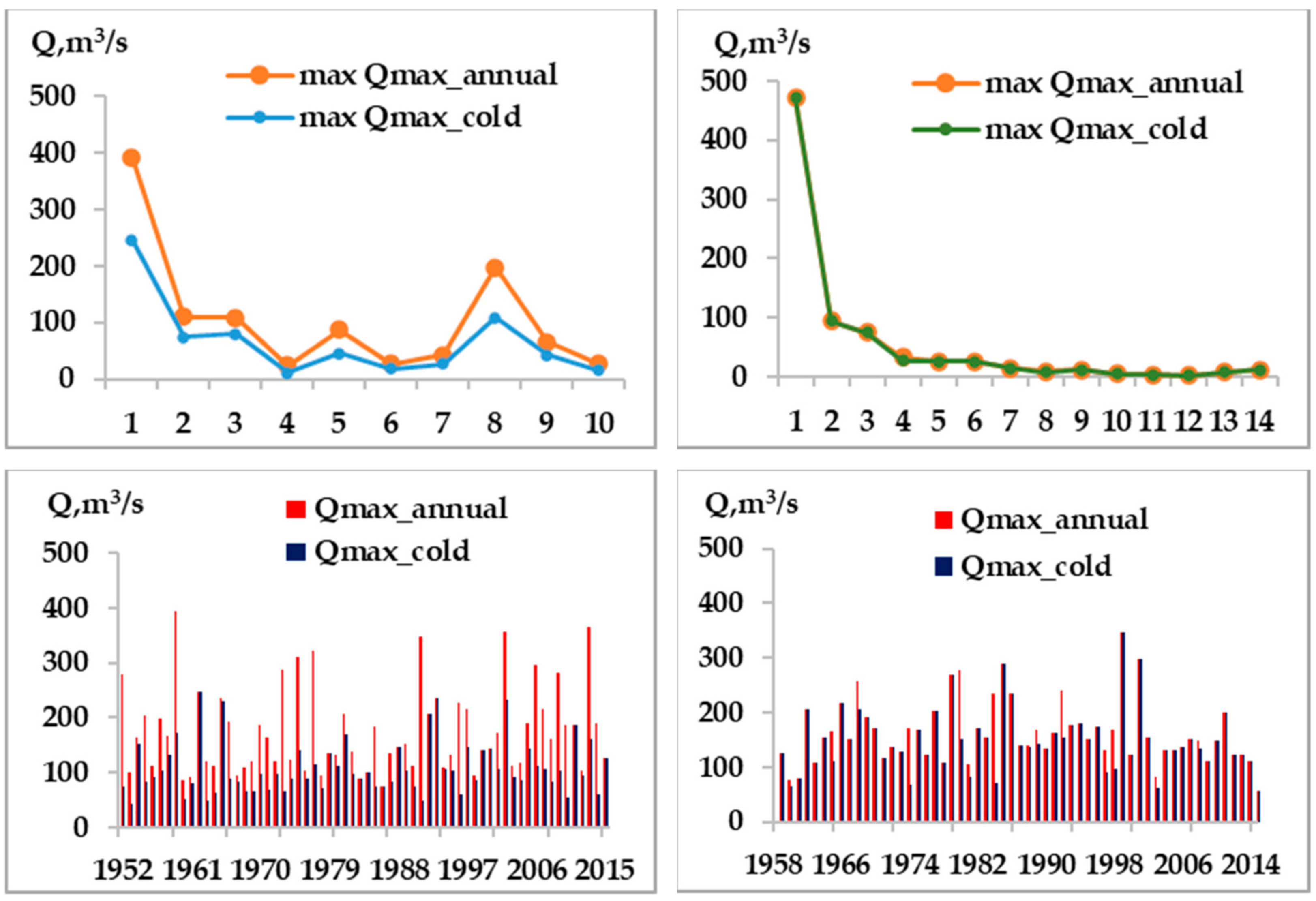
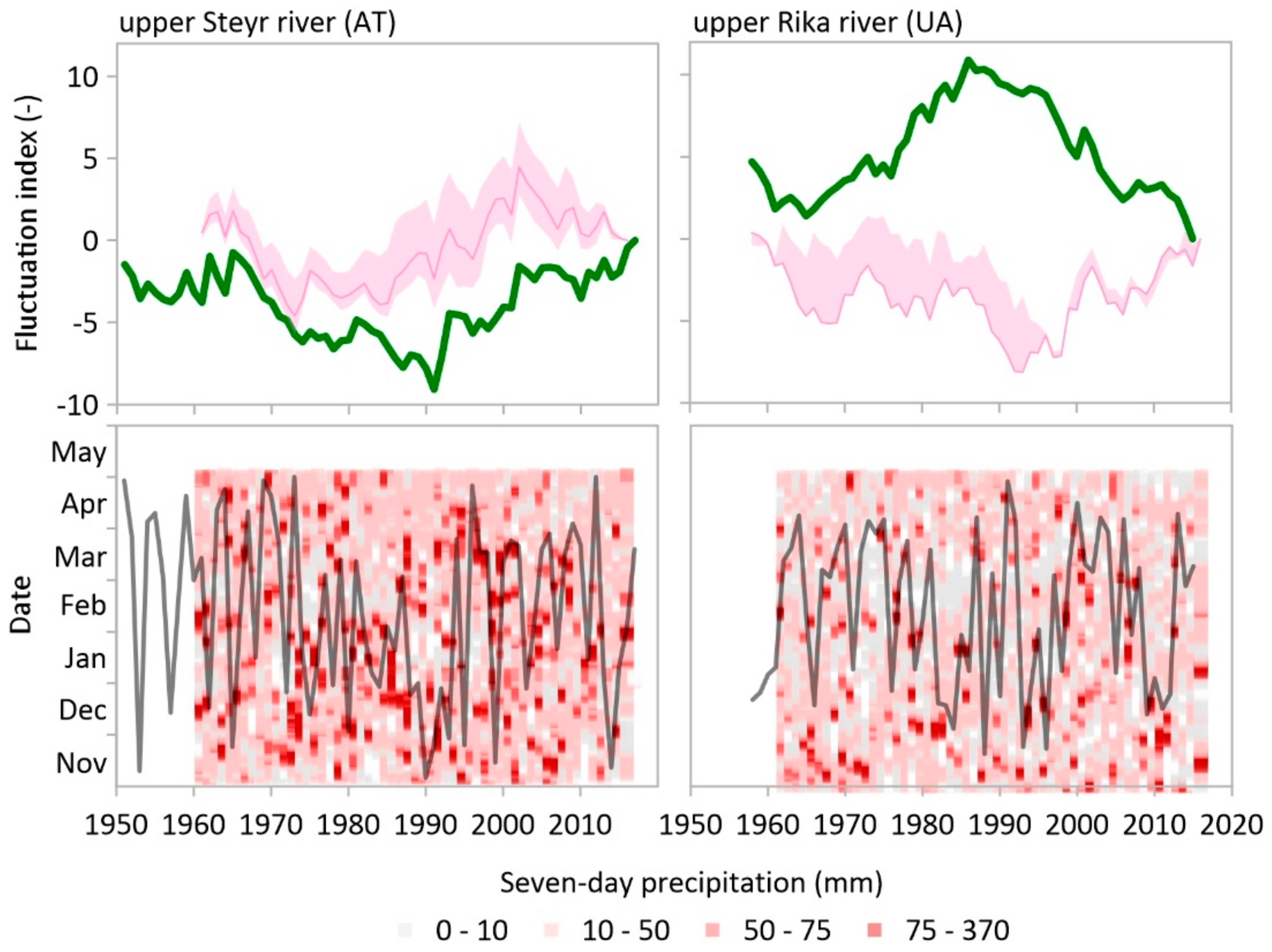
4.1. Fluctuation and Seasonality of Winter Floods

The analysis of the mass curves of the winter floods for all 24 catchments indicates that the series of observations are homogeneous. Two examples of mass curves for the largest catchments are shown in Figure 3. The plots demonstrate that the shape of mass curves does not show any significant unidirectional deviations in the 60 and 70 years.
Figure 4 show the residual mass curves for Austrian (left panel) and Ukrainian (right panel) catchments. The shape of the residual mass curve indicates cyclical and synchronous fluctuations in the winter floods series. The results show a distinct difference between the Austrian and Ukrainian parts of the Danube River basin fluctuations. While the magnitude and length of the cycles in Austrian catchments is smaller, most of the Ukrainian catchments show a distinct fluctuation pattern consisting of an increasing phase of winter flood magnitude from the mid-1960s until the end of the 1980s, followed by a decrease until the recent period (2015). The exceptions are fluctuations in headwater catchments Pylypets River (ID = UA8), Branyshche Stream (ID = UA9), and Pylypetskyi Stream (ID = UA10), which are much smaller and have a significantly increasing phase in the 1980–2000 period. In contrary, most of the Austrian catchments have a decreasing phase between the mid-1960s and 1990s, followed by a sharp increase in winter flood magnitude until 2010.
The seasonality of winter floods of both regions is presented in Figure 5. The left and right panels show the occurrence of winter floods in the upper Steyr and upper Rika catchments, respectively. The green lines indicate the winter flood fluctuations for the largest catchments in both regions (ID = AT1, ID = UA1). The results show that the variability of flood occurrence in individual years is larger in the Austrian than in the Ukrainian catchments. The variability is mainly related to the larger topographical variability of Austrian catchments. The earliest occurrence of winter flood maxima in the upper Steyr catchment is observed mostly at Klaus an der Pyhrnbahn gauge, which is the main outlet. The latest occurrence is typically observed in the highest catchment (Polsterlucke, ID = AT10) and the difference between the occurrence of flood maxima between the catchments in individual years can exceed 3–4 months. The largest floods in Austrian catchments tend to occur in November/December. In the upper Rika River, the inter-annual variability of flood occurrence is also large, but the variability between the catchments is notably smaller than in Austrian catchments. Interestingly, the smallest between-catchment variability is observed between 1985 and 1995, which is the start of the main fluctuation decline. During this period, most of the floods occur in November/December.

4.2. Factors Controlling Winter Flood Fluctuations

For a more detailed characterization of the fluctuations of winter floods, Figure 6, Figure 7 and Figure 8 compare winter flood fluctuations with the fluctuations and seasonality of 7-day sum of precipitation, melt index based on sum of positive air temperature, and maximum snow depth. Pink bands in Figure 6 (top panels) show the fluctuations of winter maximum (seven-day) precipitation in the upper Steyr (left) and upper Rika (right) catchments. The fluctuations in the upper Steyr are synchronous with fluctuations in winter floods (green line). In the upper Rika catchment, the positive phase (i.e., an increase) in flood magnitude until 1990 is not associated with an increase in maximum precipitation, particularly between 1980 and 1990. An increase in maximum precipitation after 2010 also does not correspond with flood fluctuations, which are in this period in a negative phase (decreasing floods).
The seasonality of maximum precipitation (Figure 6, bottom panels) has a very strong inter-annual variability and the winter maxima tend to occur either in November/December or March/April. In both regions, there are no clear links between flood and precipitation fluctuations and the seasonality of maximum precipitation.
Fluctuations of positive air temperature sums are presented in Figure 7 (top panels). In both regions, they have a similar cycle showing a decreasing phase (cooling) until the 1990s, followed by a continuous increasing phase until recent years. The region’s difference is mainly in the declining phase, which is less pronounced in Ukrainian catchments in 1960–1980. On the other hand, the positive increasing phase starts in the upper Rika catchment later than in the Steyr catchment. The seasonality of the melt index does not show a clear pattern related to the fluctuations of floods. There is a strong inter-annual variability, but the differences between the regions cannot explain the difference in the flood fluctuations.
The difference between the occurrence of floods and the occurrence of maximum precipitation and start of the melt season is examined in Figure 8. The positive and negative values indicate the later and earlier occurrence of floods than the occurrence of maximum winter precipitation (pink bars) and melt start (brown bars), respectively. Figure 8 shows that in the upper Steyr catchment, the positive phase of flood fluctuations (after 2000) occurs when the flood occurrence coincides with the occurrence of maximum winter precipitation. The stable phase in the 1970s is associated with floods occurring in March and April, but the maximum precipitation occurred in the beginning of winter. The same pattern is observed in the upper Rika catchment. The peak of positive phase (i.e., mid-1980s and 1990s) is characterized by a coincidence of floods and maximum precipitation.
The fluctuations of annual maximum daily snow depth are presented in Figure 9. In the upper Steyr catchment, the maximum snow depth fluctuations follow the fluctuations in winter floods. The periods of increasing or decreasing phases correspond to the phase of flood fluctuations. In the upper Rika catchment, the snow depth fluctuations are very stable in 1950–1980 and do not follow the increasing phase of the winter floods fluctuations. However, the decreasing phase of snow depths from the mid-1980s until the end of the 1990s corresponds with decreasing flood magnitudes in this period. The increase in snow depth from the beginning of the century (2000) is also reflected in a slight rise in winter flood magnitudes. The seasonality of annual snow depth maxima also has a strong inter-annual variability. Earlier snow depth maxima are associated with lower snow depth magnitude and typically smaller winter floods.

5. Discussion and Conclusions

This study compares the long-term fluctuations of winter floods in two regions in the Danube River basin. Recent studies of changes in flood seasonality and flood magnitude in Europe [2,3] show that floods have changed in the last 50 years and different drivers control these changes. One of the drivers is the change in snowmelt due to increased warming. This study compares the fluctuation of winter flood magnitudes and their seasonality in similarly sized and small catchments in Austria and Ukraine. The results show that the winter floods are synchronous and correspond well with fluctuations of sum (seven-day) of positive air temperature and maximum precipitation and snow depth. In the last decades, the increasing phase in melt temperatures has resulted in decreasing winter floods in Ukrainian catchments, which corresponds well with changes in flood magnitude identified by the author of [2] in Eastern Europe. This study, however, did not find a significant change in flood or snow characteristics as reported in [3] or [40] or North-Eastern Europe [4,5]. The seasonality of winter floods and associated climate characteristics have an extreme inter-annual variability. Even air temperatures have increased continuously in the last decade; the generation of maximum winter floods still tends to vary between the years. The recent increase in the upper Steyr catchment and stabilization of the decreasing phase of flood magnitudes in the upper Rika catchment is associated with the coincidence of floods with the occurrence of maximum precipitation and/or its combination with the snowmelt.
A previous study [28] examined flood fluctuations in many rivers in Ukraine and identified four different types of long-term fluctuations. Our results for the upper Rika catchments mostly belong to the first type characterized only by two simple phases: decreasing and increasing. The fluctuations found for the upper Steyr catchments are close to the fluctuations found for the Tysa River. These fluctuations are characterized by a smaller number of cycles with shorter duration and smaller amplitude than found in the upper Rika catchment. In future studies, it will be interesting to analyze the flood fluctuations across larger geographical transects to examine further factors and drivers controlling their variability.
The comparative assessment of similarities and differences in winter flood fluctuations suggests that the fluctuations are a reflection of the various flood producing processes. The combination of the hydro-genetic approach with the seasonality assessment allowed us to identify drivers controlling flood magnitude fluctuations. The differences in fluctuations are the reflection of the snow accumulation and melt processes and the occurrence of larger precipitation amounts. The findings indicate that the variability in winter floods is also controlled by topographical variability within the study region through the differences in the snowmelt timing. To validate the effects of elevation in the other areas and explore its interplay with the runoff generation processes, we plan to focus our next efforts on evaluating the combination of hydro-genetic method and seasonality assessment in the entire Alps-Carpathian region. The main aim will be to examine the spatio-temporal patterns of flood fluctuations along selected transects in Europe and identify regions with similar fluctuation characteristics.

Author Contributions

Conceptualization, T.Z. and J.P.; methodology, L.G. and J.P.; software, T.Z. and J.P.; validation, T.Z. and J.P.; formal analysis, T.Z. and J.P.; investigation, T.Z.; resources, T.Z. and J.K.; data curation, T.Z., O.A. and R.T.; writing—original draft preparation, T.Z.; writing—review and editing, T.Z., J.P. and B.S.; visualization, T.Z. and J.P.; supervision, G.B., J.P. and L.G.; project administration, T.Z.; funding acquisition, G.B. All authors have read and agreed to the published version of the manuscript.

Funding

This research was financed by Scholarship Foundation of the Republic of Austria. Awarding organisation is Austrian Agency for International Cooperation in Education and Research (OeAD-GmbH), Centre for International Cooperation & Mobility (ICM). Name of the scholarship - Scholarship of the Scholarship Foundation of the Republic of Austria, Postdocs (Ref. no. ICM-2018-09824, date—26 April 2018).

Institutional Review Board Statement

Not applicable.

Informed Consent Statement

Not applicable.

Data Availability Statement

Daily runoff observations were taken from the Central Geophysical Observatory named after Boris Sreznevsky in Ukraine and the Hydrographic Service of Austria (https://ehyd.gv.at/m access date 14 February 2022).

Acknowledgments

The authors would like to acknowledge the financial support provided by Scholarship Foundation of the Republic of Austria. Great appreciation to the Institute of Hydrology and Water Resource Management, Vienna University of Technology, for support during the scholarship and the preparation of this manuscript.

Conflicts of Interest

The authors declare no conflict of interest.

References

  1. Hall, J.; Arheimer, B.; Borga, M.; Brázdil, R.; Claps, P.; Kiss, A.; Kjeldsen, T.R.; Kriaučiūnienė, J.; Kundzewicz, Z.W.; Lang, M.; et al. Understanding flood regime changes in Europe: A state-of-the-art assessment. Hydrol. Earth Syst. Sci. 2014, 18, 2735–2772. [Google Scholar] [CrossRef] [Green Version]
  2. Blöschl, G.; Hall, J.; Viglione, A.; Perdigão, R.A.P.; Parajka, J.; Merz, B.; Lun, D.; Arheimer, B.; Aronica, G.T.; Bilibashi, A.; et al. Changing climate both increases and decreases European river floods. Nature 2019, 573, 108–111. [Google Scholar] [CrossRef] [PubMed]
  3. Blöschl, G.; Hall, J.; Parajka, J.; Perdigão, R.A.P.; Merz, B.; Arheimer, B.; Aronica, G.T.; Bilibashi, A.; Bonacci, O.; Borga, M.; et al. Changing climate shifts timing of European floods. Science 2017, 357, 588–590. [Google Scholar] [CrossRef] [PubMed] [Green Version]
  4. Kireeva, M.B.; Rets, E.P.; Frolova, N.L.; Samsonov, T.E.; Povalishnikova, E.S.; Entin, A.L.; Durmanov, I.N.; Ivanov, A.M. Occasional Floods On The Rivers Of Russian Plain In the 20th–21st Centuries. Geography, Environment. Sustainability 2020, 13, 84–95. [Google Scholar] [CrossRef]
  5. Volchek, A.A.; Shelest, T.A. Formation of winter floods on the rivers of Belarus, Scientific notes of the Russian State Hydrometeorological University, Rubric. Hydrology 2012, 25, 5–19. (In Russian) [Google Scholar]
  6. Pekarova, P.; Miklanek, P.; Melo, M.; Halmova, D.; Pekar, J.; Bacova Mitkova, V. Flood Marks along the Danube River between Passau and Bratislava; Veda and the Slovak Committee for Hydrology: Bratislava, Slovakia, 2014; 104p. [Google Scholar]
  7. Blöschl, G.; Nester, T.; Komma, J.; Parajka, J.; Perdigao, R.A.P. The June 2013 flood in the Upper Danube basin, and comparisons with the 2002, 1954 and 1899 floods. Hydrol. Earth Syst. Sci. 2013, 10, 9533–9573. [Google Scholar] [CrossRef] [Green Version]
  8. Böhm, O.; Wetzel, F. Flood history of the Danube tributaries Lech and Isar in the Alpine foreland of Germany. Hydrol. Sci. J. 2006, 51, 784–798. [Google Scholar] [CrossRef]
  9. Prykhodko, M.M. Floods and their management in the Carpathian region of Ukraine. Sci. Bull. Natl. Min. Univ. 2017, 2, 112–117. [Google Scholar]
  10. Susidko, M.; Luk’yanets, O. The Carpathians—Flood Danger Region of Ukraine. Comprehensive Basin Flood Forecasting System in Zakarpattya: Methodical and Technological Basis of Its Components; Nika-Centre: Kyiv, Ukraine, 2009; 88p, (in Ukrainian, English, German). [Google Scholar]
  11. Bauzha, T.O. Flood flow the cold period in the Rika River basin and its calculated characteristics. Hydrol. Hydrochem. Hydroecol. 2012, 2, 73–80. (in Ukrainian). [Google Scholar]
  12. Susidko, M.; Luk’yanets, O. Zoning of the territory of Ukraine according to the degree of hydrological danger. Proc. Ukr. Hydrometeorol. Inst. 2004, 253, 196–204. (In Ukrainian) [Google Scholar]
  13. Korchynska, Z. Analysis of natural and anthropogenic factors of catastrophic flooding’s growth in Transcarpathia. Sci. Bull. Uzhhorod Univ. 2013, 2, 51–57. [Google Scholar]
  14. Ya, K. Catastrophic floods in Carpathians and directions of their prevention. Lviv Proc. For. Acad. Sci. Ukr. 2008, 6, 1–11. (in Ukrainian). [Google Scholar]
  15. Pylkevuch, I.; Kotkov, V.; Maievskyi, O. Emergency monitoring dealed with catastrophic floods in Carpathians. East. European J. Enterp. Technol. 2012, 1, 25–31. [Google Scholar] [CrossRef]
  16. Merz, R.; Blöschl, G. A process typology of regional floods. Water Resour. Res. 2003, 39, 1340. [Google Scholar] [CrossRef]
  17. Gaál, L.; Szolgay, J.; Kohnová, S.; Parajka, J.; Merz, R.; Viglione, A.; Blöschl, G. Flood timescales: Understanding the interplay of climate and catchment processes through comparative hydrology. Water Resour. Res. 2012, 48, W04511. [Google Scholar] [CrossRef]
  18. Gorbachova, L. Methodical approaches the assessment of the homogeneity and stationarity of hydrological observation series. Hydrol. Hydrochem. Hydroecol. 2014, 1, 22–31. (In Ukrainian) [Google Scholar]
  19. Gaudry, C.M.M.; Gutknecht, D.; Parajka, J.; Perdigão, R.A.P.; Blöschl, G. Seasonality of runoff and precipitation regimes along transects in Peru and Austria. J. Hydrol. Hydromech. 2017, 65, 347–358. [Google Scholar] [CrossRef] [Green Version]
  20. Bauzha, T.O.; Gorbachova, L.O. Estimation of the homogeneity of the average annual runoff of the rivers and streams of the Zacarpatska station. In Proceedings of the International Conference on Water, Climate and Environment, BALWOIS 2012, Ohrid, Republic of Macedonia, 28 May–2 June 2012; Available online: https://balwois.com/wp-content/uploads/old_proc/815.pdf (accessed on 24 January 2022).
  21. Gorbachova, L.; Bauzha, T. Complex analysis of stationarity and homogeneity of flash flood maximum discharges in the Rika River basin. Energetika 2013, 59, 167–174. [Google Scholar] [CrossRef]
  22. Bauzha, T.O.; Gorbachova, L.O. Cyclical fluctuations of the hydrometeorological characteristics in the Rika River Basin. Proc. UHMI 2013, 264, 34–43. Available online: https://uhmi.org.ua/pub/np/264/Bauzha_Gorbachova_264.pdf (accessed on 24 January 2022). (in Ukrainian with English summary).
  23. Bauzha, T.O. The spatial and temporal regularities of the water courses in the Rika River Basin: The thesis abstract for the degree of candidate of geographical sciences, speciality 11.00.07—Land hydrology, water resources, hydrochemistry. Kyiv, 2014; 20p, (in Ukrainian with English summary). [Google Scholar]
  24. Gorbachova, L.; Khrystyuk, B. Hydro-genetic methods of the analysis of the average annual runoff in the Danube basin. The hydrological forecasting and hydrological bases of water management. Bridging the sciences—crossing borders. In Proceedings of the XXVI Conference of the Danubian Countries, Deggendorf, Germany, 22–24 September 2014; Dorner, W., Marquardt, A., Schroder, U., Eds.; Deggendorf Institute of Technology: Deggendorf, Germany, 2014; pp. 71–74. [Google Scholar]
  25. Gorbachova, L.O. Hydro-Genetic Analysis of the Spatio-Temporal Regularities of Streamflow Rivers of Ukraine: Methodology, Trends, Forecast: The Thesis Abstract for the Degree of Doctor of Geographical Sciences Speciality 11.00.07—Land Hydrology, Water Resources, Hydrochemistry, Kviv. 2017. Available online: http://scc.univ.kiev.ua/upload/iblock/0e7/aref_Gorbachova%20L.O..pdf (accessed on 24 January 2022). (in Ukrainian with English Summary).
  26. Bauzha, T. Hydro-genetic analysis of the long-term fluctuations of the average annual water temperature in the Siverskyi Donets River basin (within Ukraine). In Proceedings of the XXVII Conference of the Danubian Countries on Hydrological Forecasting and Hydrological Bases of Water Management, Golden Sands, Bulgaria, 26–28 September 2017; pp. 105–111. Available online: https://www.danubeconference2017.org/images/e-book_full_texts_dc_2017.pdf (accessed on 24 January 2022).
  27. Zabolotnia, T. Estimation of the long-term tendencies and homogeneity of the average annual water temperature and air temperature in the Siverskyi Donets River Basin (within Ukraine). J. Fundam. Appl. Sci. 2018, 10, 1–22. [Google Scholar]
  28. Zabolotnia, T.; Gorbachova, L.; Khrystiuk, B. Estimation of the long-term cyclical fluctuations of snow-rain floods in the Danube basin within Ukraine. Meteorol. Hydrol. Water Manag. 2019, 7, 3–11. [Google Scholar] [CrossRef]
  29. Parajka, J.; Merz, R.; Szolgay, J.; Blöschl, G.; Kohnová, S.; Hlavcová, K. A comparison of precipitation and runoff seasonality in Slovakia and Austria. Meteorol. J. 2008, 11, 9–14. [Google Scholar]
  30. Parajka, J.; Kohnová, S.; Merz, R.; Szolgay, J.; Hlavčová, K.; Blöschl, G. Comparative analysis of the seasonality of hydrological characteristics in Slovakia and Austria. Hydrol. Sci. J. 2009, 54, 456–473. [Google Scholar] [CrossRef]
  31. Falkenmark, M.; Chapman, T. (Eds.) Comparative Hydrology: An Ecological Approach to Land and Water Resources; UNESCO: Paris, France, 1989. [Google Scholar]
  32. Materials of observations of the Zakarpatska water-balance station. Kyiv 2016, 57, 5. (in Ukrainian).
  33. Zabolotnia, T.; Szeles, B.; Gorbachova, L.; Parajka, J.; Tong, R. Comparison of winter design floods between Austrian and Ukrainian Danube River tributaries. Acta Hydrol. Slovaca 2021, 22, 256–263. [Google Scholar] [CrossRef]
  34. Girkinger, W.; Heitzmann, W. Die Steyr: Landschaft und Menschen am Fluß; Oberösterreichischer Landesverlag: Linz, Austria, 1990; ISBN 3-85214-527-9. [Google Scholar]
  35. Hiebl, J.; Frei, C. Daily temperature grids for Austria since 1961—concept, creation and applicability. Theor. Appl. Climatol. 2016, 124, 161–178. [Google Scholar] [CrossRef]
  36. Hiebl, J.; Frei, C. Daily precipitation grids for Austria since 1961-development and evaluation of a spatial dataset for hydroclimatic monitoring and modelling. Theor. Appl. Climatol. 2018, 132, 327–345. [Google Scholar] [CrossRef]
  37. Grishchenko, V.F.; Aksiuk, O.M.; Honcharenko, H.A. The Guide of Snow Cover in the Mountains of Ukraine (Carpathians, Crimea); Ukrainian Hydromet Institute: Kiev, Ukraine, 2013; 218p, Available online: https://uhmi.org.ua/pub/books/snow_2013.pdf (accessed on 24 January 2022). (In Ukrainian)
  38. Andreyanov, V.G. Cyclical fluctuations of annual runoff and their account at hydrological calculations. Proceed. Stat. Hydr. Inst. 1959, 68, 3–49. (In Russian) [Google Scholar]
  39. Gorbachova, L.O. Place and role of hydro-genetic analysis among modern research methods runoff. Proceed. Ukrain. Hydrometeorol. Instit. 2016, 268, 73–81. (In Ukrainian) [Google Scholar]
  40. Hundecha, Y.; Parajka, J.; Viglione, A. Assessment of past flood changes across Europe based on flood-generating processes. Hydrol. Sci. J. 2020, 65, 1830–1847. [Google Scholar] [CrossRef]
Figure 1. Location of the study catchments in the Danube River basin. The Austrian part consists of 10 catchments located in the upper Steyr basin (bottom left panel). The 14 Ukranian catchments are situated in the Rika River basin (bottom right panel). Labels of symbols refer to ID number in Table 1 (upper Rika River) and Table 2 (upper Steyr river).
Hydrology 09 00038 g001
Figure 2. Comparison of the long-term maximum winter and annual floods in the upper Steyr (top left) and the upper Rika (top right) catchments. Labels of symbols refer to ID number in Table 1 (upper Rika) and Table 2 (upper Steyr), bottom left—Steyr River—Klaus an der Pyhrnbahn, bottom right—Rika River—Mizhhiria.
Hydrology 09 00038 g002
Figure 3. Mass curves of winter floods in the upper Steyr (left panel) and upper Rika (right panel) River basin.
Hydrology 09 00038 g003
Figure 4. Fluctuations of maximum winter floods in the upper Steyr (a) and upper Rika catchments (b). Labels of symbols refer to ID number in Table 1 (upper Rika) and Table 2 (upper Steyr).
Hydrology 09 00038 g004
Figure 5. Seasonality of winter floods (grey lines). The grey band represents the variability of flood occurrence between the catchments from the same region. The green line indicates fluctuation index in the Steyr River−Klaus an der Pyhrnbahn (left) and Rika River−Mizhhiria village (right) catchments.
Hydrology 09 00038 g005
Figure 6. Fluctuations (top panels) and seasonality (bottom panels) of the winter maximum seven−day precipitation in the upper Steyr and the upper Rika catchments. Variability in maximum precipitation (pink band in left top panel) is plotted for all sub-catchments in the upper Steyr catchment. For Mizhhiria station in the upper Rika River (top right panel), the pink band indicates the variability between precipitation observations at three (Mizhhiria, Nyzhnii Studenyi, Verkhnii Bystryi) climate stations (Table 4). The green line indicates the fluctuation index of the winter floods (top panels). Bold lines (bottom panels) represent the season of the maximum precipitation in each year.
Hydrology 09 00038 g006
Figure 7. Fluctuations (top panels) of the sum of positive air temperature and seasonality (bottom panels) of the seven−day melt index in the upper Steyr and the upper Rika catchments. Variability in the sum of positive air temperature (brown band in left top panel) is plotted for all sub−catchments in the upper Steyr catchment and Mizhhiria station in the upper Rika River (top right panel). The green line indicates the fluctuation index of the winter floods (top panels). Bold lines (bottom panels) represent the seasonality of the snowmelt index, i.e., the first full seven days in a year when surface air temperatures exceed 0 °C.
Hydrology 09 00038 g007
Figure 8. Difference in the occurrence of winter floods and the occurrence of maximum precipitation (pink bars) and melt index (brown bars). Positive difference (days) indicates that floods occur later than maximum (seven−day) precipitation or occurrence of (seven-day) positive air temperatures. The green line indicates the fluctuation index of the winter floods.
Hydrology 09 00038 g008
Figure 9. Fluctuations (top panels) and seasonality (bottom panels) of the winter floods and observed snow depth in the upper Steyr and the upper Rika catchments. Lines show fluctuation and seasonality of winter floods in the Steyr River−Klaus an der Pyhrnbahn (left) and Rika River−Mizhhiria village (right) catchments. Variability in snow depth fluctuation (blue band in top panels) is plotted for climate stations listed in Table 4. The green line indicates the fluctuation index of the winter floods (top panels). Daily snow depth seasonality is presented for the Spital am Pyhrn (Austria, 630 m a.s.l.) and Nyzhnii Studenyi (Ukraine, 615 m a.s.l.).
Hydrology 09 00038 g009
Table 1. Characteristics of the catchments and geographical coordinates of the catchment outlets in the upper Rika River Basin (Ukraine).
IDCatchmentArea (km2)LatitudeLongitudeMean Elevation
(m a.s.l.)
UA1Rika River—Mizhhiria village55048°32′20″23°29′47″800
UA 2Rika River—Verkhnii Bystryi village16548°37′36″23°30′50″920
UA 3Holiatynka River—Maidan village8648°36′54″23°27′17″790
UA 4Pylypets River—Pylypets village4448°40′15″23°20′29″854
UA 5Lopushna River—Lopushne village (nyzhn.)3748°39′13″23°34′46″897
UA 6Studenyi River—Nyzhnii Studenyi village2548°42′38″23°22′06″800
UA 7Ploshanka Stream—Pylypets village (nyzhn.)2048°40′14″23°20′27″983
UA 8Lopushna River—Lopushne village (verkhn.)1348°38′41″23°37′39″925
UA 9Branyshche Stream—Lopushne village1048°38′56″23°37′22″916
UA 10Studenyi River—Verkhnii Studenyi village8.048°45′03″23°21′22″809
UA 11Pylypets River—Podobovets village7.448°40′32″23°18′36″747
UA 12Pylypetskyi Stream—Pylypets village5.748°39′43″23°19′00″1000
UA 13Ziubrovets Stream—Lopushne village3.248°38′44″23°36′49″871
UA 14Serednii Zvir Stream—Lopushne village2.248°38′48″23°36′28″984
Table 2. Characteristics of catchments and geographical coordinates of the catchment outlets in the Steyr River basin (Austria).
IDCatchmentArea (km2)LatitudeLongitudeMean Elevation
(m a.s.l.)
AT 1Steyr River—Klaus an der Pyhrnbahn54547°49′51″14°09′37″1059
AT 2Teichl River—St. Pankraz23147°45′59″14°12′35″1009
AT 3Steyr River—Kniewas19047°46′04″14°10′12″1213
AT 4Teichl River—Teichlbrücke14747°43′37″14°17′44″1015
AT 5Steyr River—Hinterstoder8647°41′38″14°08′27″1358
AT 6Steyrling River—Steyrling7247°48′20″14°08′17″951
AT 7Dambach River—Windischgarsten6647°43′20″14°19′57″1016
AT 8Teichl River—Spital am Pyhrn3947°40′09″14°20′05″1205
AT 9Steyr River—Dietlgut2647°40′08″14°06′33″1375
AT 10Krumme Steyr River—Polsterlucke1847°41′34″14°06′51″1506
Table 3. The length of flood records, coefficient of variation Cv (November–April) and the largest and smallest winter (November–April) and annual (November–October) flood discharges.
IDThe Name of GaugeQmax. cold period, m3/sQmax. annual, m3/sCvPeriod
MaxMinmaxmin
UA 1Rika R.—Mizhhiria v.471 (12/1957)55.1 (03/2015)471 (12/1957)55.1 (03/2015)0.461957–2015
UA 2Rika R.—Verkhnii Bystryi v.93.8 (11/1998)9.53 (03/2015)93.8 (11/1998)13.0 (05/2015)0.421957–2015
UA 3Holiatynka R.—Maidan v.74.1 (12/1957)7.58 (03/2015)74.1 (12/1957)7.58 (03/2015)0.511957–2015
UA 4Pylypets R.—Pylypets v.27.3 (11/1972)3.86 (04/2003)32.8 (09/1968)4.73 (01/2015)0.441957–2015
UA 5Studenyi R.—Nyzhnii Studenyi v.26.0 (11/1998)2.39 (03/2015)26.0 (11/1998)3.48 (07/1961)0.551957–2015
UA 6Lopushna R.—Lopushne (nyzhn.) v.25.6 (12/1957)2.89 (03/2003)25.6 (12/1957)3.44 (05/2015)0.471957–2015
UA 7Ploshanka S.—Pylypets (nyzhn.) v.14.4 (01/1985)1.00 (03/2015)14.4 (01/1985)1.22 (05/2015)0.441957–2015
UA 8Pylypets R.—Podobovets v.7.60 (12/1985)0.76 (03/2015)8.72 (10/1992)0.76 (03/2015)0.491957–2015
UA 9Branyshche S.—Lopushne v.11.2 (12/1957)0.57 (01/2015)11.2 (12/1957)0.91 (05/2015)0.671957–2015
UA 10Pylypetskyi S.—Pylypets v.5.14 (01/1985)0.42 (03/2015)5.14 (01/1985)0.78 (10/2015)0.461957–2015
UA 11Ziubrovets S.—Lopushne v.2.89 (12/1957)0.22 (04/2003)2.89 (12/1957)0.25 (10/2003)0.531957–2015
UA 12Serednii Zvir S.—Lopushne v.2.40 (11/1998)0.14 (04/2003)2.40 (11/1998)0.23 (06/2015)0.681957–2015
UA 13Studenyi R.—Verkhnii Studenyi v.7.99 (11/1998)0.97 (11/1972)7.99 (11/1998)0.99 (07/1961)0.601958–2015
UA 14Lopushna R.—Lopushne (verkhn.) v.11.0 (11/1998)1.16 (03/1960)11.0 (11/1998)1.16 (03/1960)0.571959–2015
AT 1Steyr River—Klaus an der Pyhrnbahn246 (12/1961)42.7 (11/1952)393 (08/1959)74.5 (01/1986)0.441951–2015
AT 2Teichl River—Teichlbrücke74.0 (11/1964)10.8 (04/1969)110 (06/2013)15.5 (04/1986)0.521951–2015
AT 3Steyr River—Kniewas80.0 (11/1964)10.1 (02/1960)109 (08/2006)28.1 (05/1986)0.491951–2015
AT 4Steyr River—Dietlgut10.7 (12/1974)1.56 (04/1984)24.2 (07/1977)3.72 (06/2003)0.441951–2015
AT 5Steyrling River—Steyrling45.4 (11/1964)5.65 (03/1963)87.0 (08/1959)10.3 (07/1990)0.461956–2015
AT 6Teichl River—Spital am Pyhrn18.2 (11/1992)4.20 (03/1991)26.3 (08/1991)6.39 (10/2003)0.331966–2015
AT 7Dambach River—Windischgarsten27.0 (11/1993)3.80 (03/1991)42.7 (08/2002)5.96 (12/2002)0.521971–2015
AT 8Teichl River—St. Pankraz109 (11/1992)19.6 (03/1991)197 (06/2013)33.7 (05/1986)0.421976–2015
AT 9Steyr River—Hinterstoder41.9 (11/1992)6.07 (04/1984)65.6 (08/2002)19.0 (09/2003)0.451976–2015
AT 10Krumme Steyr River—Polsterlucke15.7 (11/1992)2.15 (11/1983)27.0 (07/1997)10.5 (05/1994)0.481976–2015
R.—River; S.—Stream; v.–village.
Table 4. The list of stations with snow depth observation (D) in the Steyr River Basin (Austria, AT) and Rika River Basin (Ukraine, UA).
Climate StationElevation,
m a.s.l.
Dmax,
cm
Daverage,
cm
Period
UA:Nyzhnii Studenyi615144381946–2016
UA:Verkhnii Studenyi *600–700143491956–2016
UA:Verkhnii Bystryi545123381949–2016
UA:Mizhhiria456119321949–2016
UA:Maidan49973281983–2016
AT:Windischgarsten (Schule)604173711970–2016
AT:Hinterstoder590170661970–2016
AT:Spital am Pyhrn630169681970–2016
AT:St. Pankraz598170611970–2016
AT: Klaus an der Pyhrnbahn461110421970–2016
* represents regular snow course measurements.
Publisher’s Note: MDPI stays neutral with regard to jurisdictional claims in published maps and institutional affiliations.

