
Comprehensive Overview of Flood Modeling Approaches: A Review of Recent Advances

 ,
,  , and
, and
Abstract
:1. Introduction
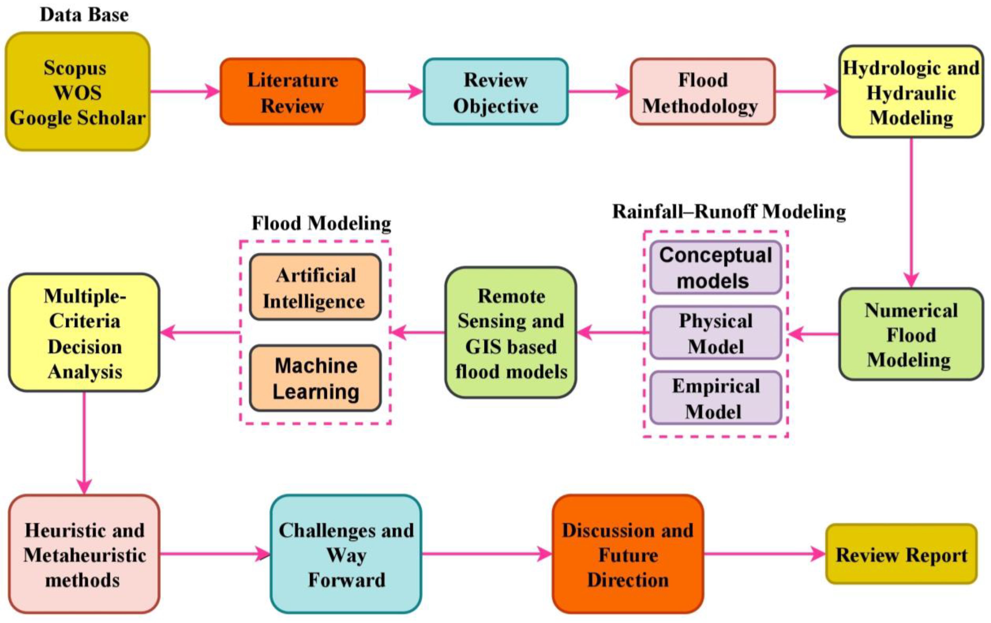
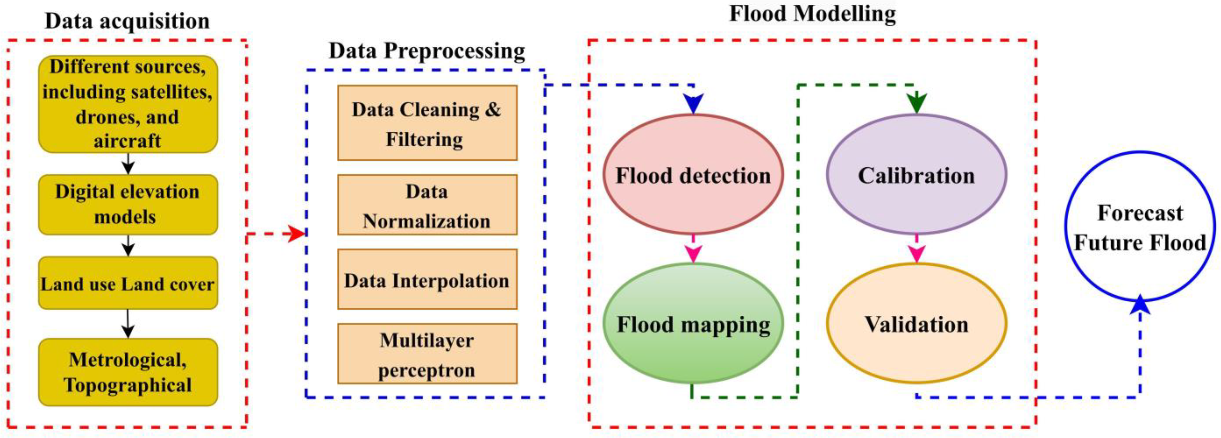
2. Research Methodology
- (a)
- Define the study area—Determine the geographical area that will be investigated for flood risk;
- (b)
- Data collection—Gather data about topography, hydrology, meteorology, land use, and other pertinent variables;
- (c)
- Hydrologic analysis—Analyze the data to identify the flow characteristics of the study area’s rivers and streams;
- (d)
- Hydraulic analysis—Use the hydrologic analysis findings to simulate water movement during a flood occurrence;
- (e)
- Floodplain mapping—Using the hydraulic analysis results, make maps that depict the extent of potential floodplain inundation;
- (f)
- Risk assessment—Take into account the potential consequences of a flood occurrence, such as damage to buildings and infrastructure, casualties, and financial impact;
- (g)
- Flood mitigation planning—Construct levees and floodwalls, non-structural measures including zoning and land use regulations, and emergency preparation and response to lessen the danger of flooding disasters;
- (h)
- Implementation and monitoring—Put the mitigation strategies into action and monitor how well they work over time.

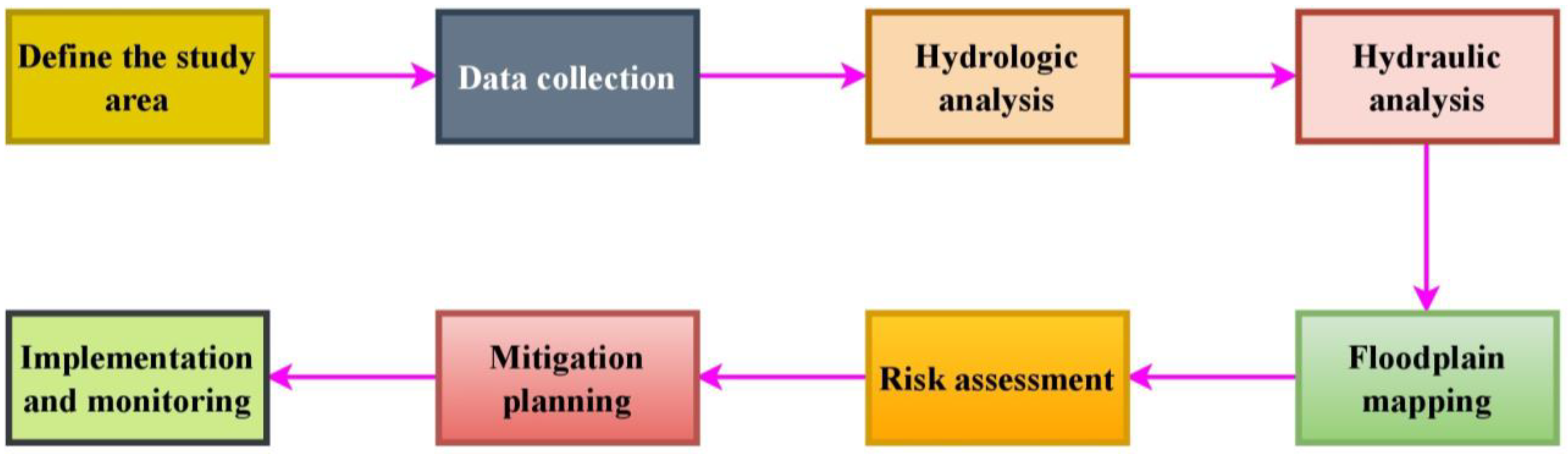
3. Hydrologic and Hydraulic Modeling
- Describe the study area—Determine the research area’s borders, taking special note of the river or watershed of interest;
- Data collection—Compile details regarding the terrain, land use, soil composition, and hydrologic parameters of the research area. For the construction and calibration of models, these data are crucial [56];
- Build the model—Build the hydrologic and/or hydraulic model using the data gathered. The model should be calibrated to make sure that predictions of flow behavior are accurate;
- Verify the model—By contrasting the predicted outcomes with the actual data, you can determine how accurate the model is. This stage is essential to making sure the model is acceptable for the research domain, and that it can be used in decision-making;
- Run simulations—After calibrating and validating the model, run simulations to predict water flow behavior under various conditions, such as land use changes or climate scenarios;
- Analyze the results to identify potential flood risks and assess flood mitigation measures [60]. This step is critical to ensuring that the modeling results are effectively communicated to stakeholders and decision-makers;
- Communicate results—Share the findings with stakeholders and decision-makers in order to inform flood management strategies and decision-making. This step is critical to ensuring that the modeling results are used to make informed flood risk management decisions.

4. Numerical Flood Modeling
- (a)
- HEC-RAS—This software, created by the US Army Corps of Engineers, is used to simulate the hydraulics of river systems in both one and two dimensions [81];
- (b)
- MIKE FLOOD—This software, which was created by DHI, is utilized for the two- and three-dimensional hydraulic modeling of floodplain and river systems [82];
- (c)
- TUFLOW—This software is used for the two-dimensional and three-dimensional hydraulic modeling of floodplain and river systems [83];
- (d)
- Flood Estimation Handbook (FEH) models—Developed by the United Kingdom Environment Agency, used for rainfall–runoff modeling and flood frequency analysis [84];
- (e)
- Environmental Protection Agency’s Environmental Fluid Dynamics Code (EFDC)—This software, developed by the United States Environmental Protection Agency, is used for three-dimensional hydraulic and water quality modeling of surface water systems [85].
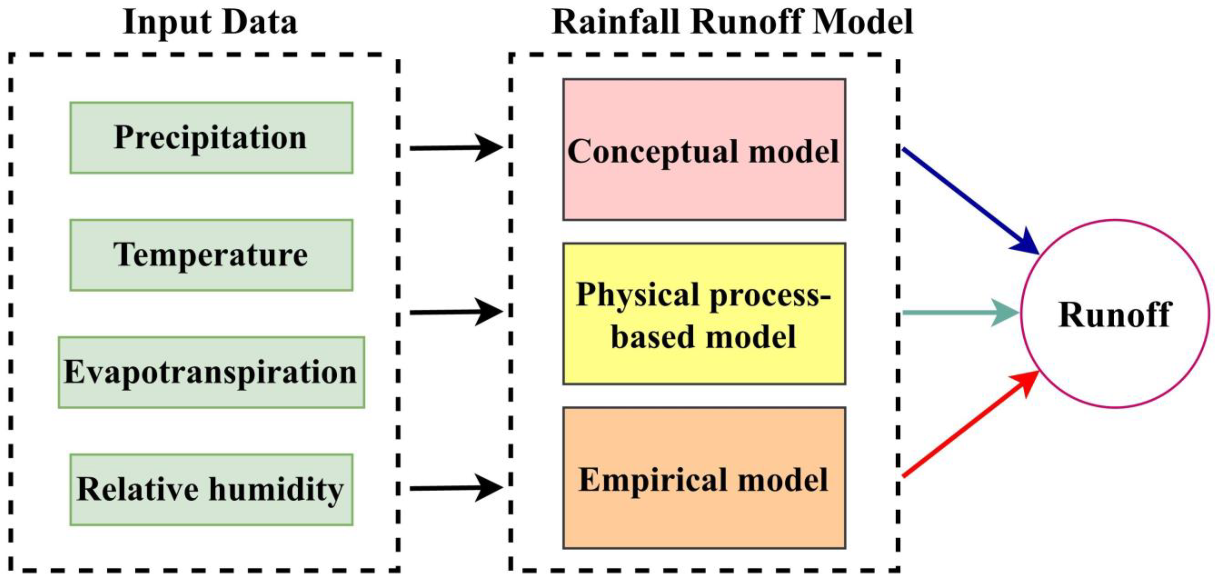
5. Rainfall–Runoff Modeling Approaches

| Model Type | Description | Strengths | Weaknesses | Related Research |
|---|---|---|---|---|
| Conceptual Models | Based on a simplified representation of the hydrological cycle | Easy to use, require only a few input parameters, useful for predicting the behavior of small to medium-sized catchments where there is a good understanding of the hydrological processes involved | May not accurately represent the physical processes involved in runoff generation, limited ability to simulate the effects of land use change and climate change | [115,116] |
| Physical Process-Based Models | Based on a detailed understanding of the physics of hydrological processes | Accurately represent the physical processes involved in runoff generation, useful for predicting runoff from large catchments and for simulating complex hydrological processes | Require a large amount of detailed data and computational resources, can be complex and time-consuming to set up and run, may be sensitive to errors in input data | [117,118] |
| Empirical Models | Based on statistical relationships between rainfall inputs and observed runoff outputs | Simple and efficient, require only historical data on rainfall and runoff, useful for flood forecasting, urban drainage design, and water resources planning | May not accurately represent the physical processes involved in runoff generation, limited ability to simulate the effects of land use change and climate change, may not perform well outside the range of historical data used to develop the model | [119] |
6. Remote Sensing and GIS-Based Flood Models
- (1)
- SRTM Flood—This model simulates the behavior of water during a flood event by using Shuttle Radar Topography Mission (SRTM) data to map the topography of a study area [152];
- (2)
- Inundation Mapping System (IMS)—The IMS is a flood risk management and emergency response software tool. It was developed by the US Army Corps of Engineers and is used to forecast the extent and depth of flooding in a specific region [153];
- (3)
- ArcGIS Flood Analysis Tool—Part of the ESRI ArcGIS software suite, this tool is used to map and evaluate flood risk, including the extent and depth of possible flood inundation, as well as to support flood risk assessment and decision-making [154].
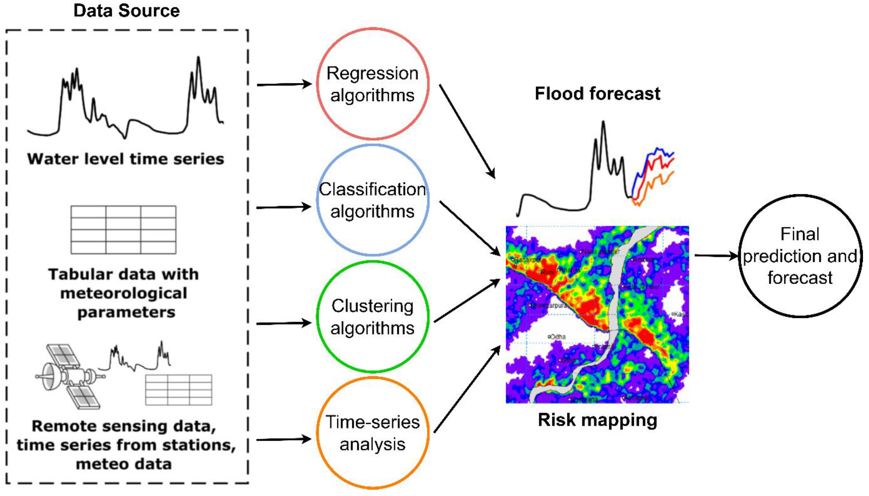
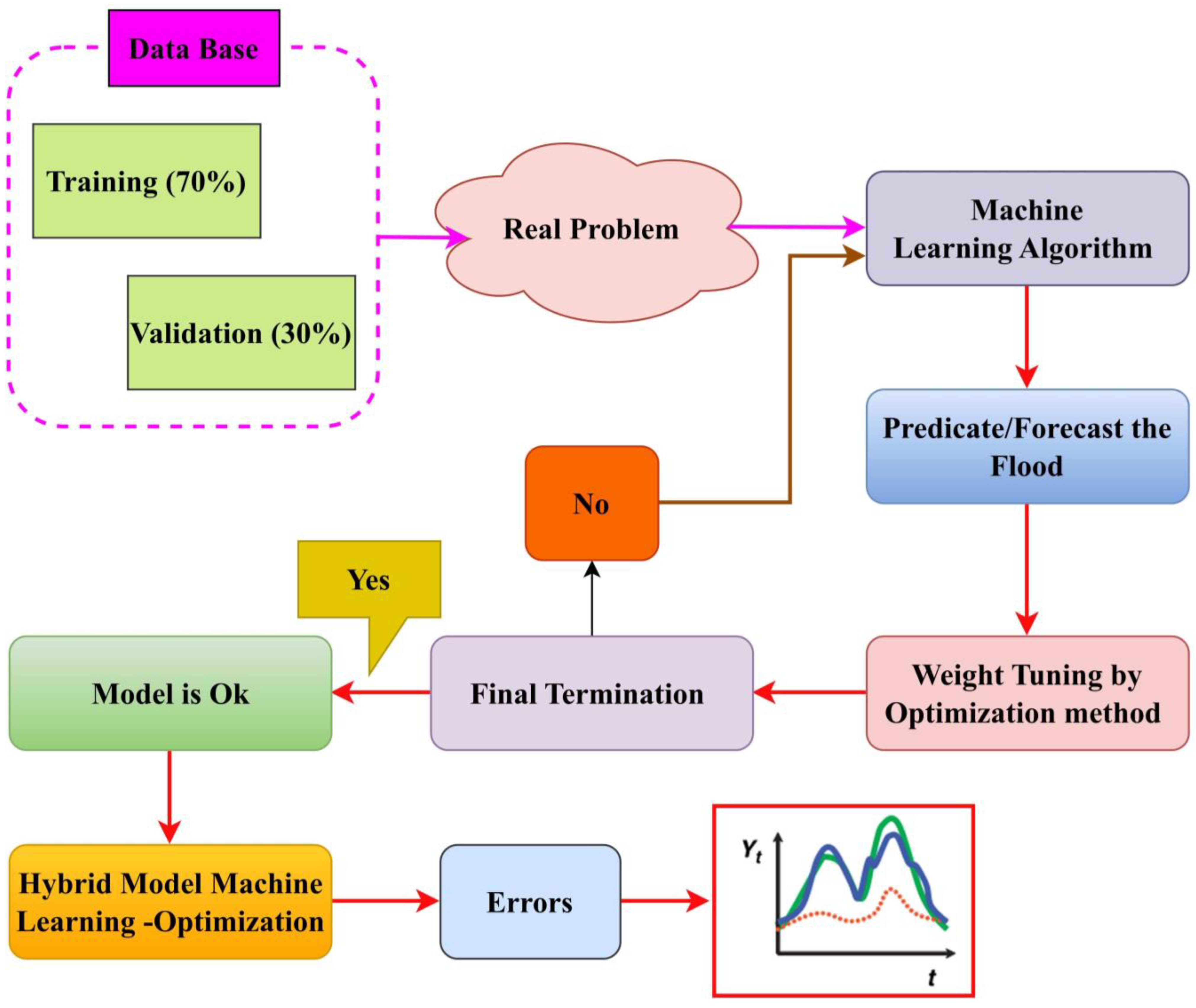
7. Flood Modeling Using Artificial Intelligence and Machine Learning
- (a)
- Predictive modeling—AI and ML algorithms can be used to build predictive models that can provide flood warnings and forecasts. These models can be developed using historical data and updated in real time as new data become available [185];
- (b)
- Data analysis—AI and ML algorithms can be used to analyze large amounts of data, such as remote sensing and GIS data, to identify patterns and trends that can provide insights into flood causes and effects [186];
- (c)
- Risk assessment—AI and ML algorithms can be used to assess the potential consequences of a flood event, such as damage to buildings and infrastructure, loss of life, and economic impact. This knowledge can be used to support risk management and decision-making [187];
- (d)
- Mitigation planning—AI and ML algorithms can be used to create flood mitigation strategies, such as levees and floodwalls, non-structural measures such as zoning and land use laws, and emergency planning and response [188].
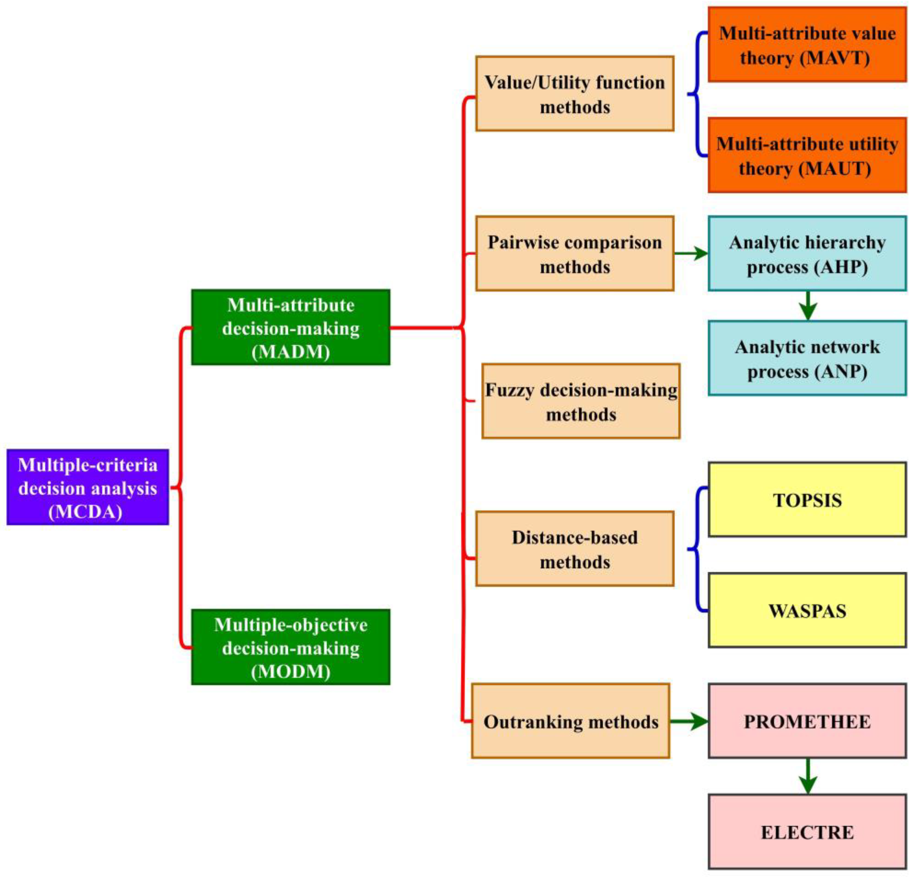
8. Multiple-Criteria Decision Analysis-Based Flood Management
- (a)
- Value/utility function methods—These techniques involve developing a function that rates each option’s value or utility in accordance with how well it fulfills each criterion. Multi-attribute value theory (MAVT) [194] and multi-attribute utility theory (MAUT) [195] are two examples of value/utility function methods. It serves to assess and compare various flood mitigation options based on a variety of criteria including cost, effectiveness, environmental impact, and social acceptance;
- (b)
- Pairwise comparison methods—In these approaches, the options are ranked by making pairwise comparisons of the way each option compares to other in terms of the way well it fulfills each criterion [196]. Analytic hierarchy process (AHP) [197] and the analytic network process (ANP) [198] are two examples of pairwise comparison techniques. These techniques are used to prioritize emergency response actions, such as evacuation, rescue, and relief efforts, during a flood event [199]. They compare the efficacy of various response actions based on factors such as speed of response, responder safety, and affected population;
- (c)
- Outranking techniques—These techniques evaluate each alternative to every other option in terms of how well they fulfill each criterion in order to identify which possibilities “outrank” others [200]. Outranking techniques include, for example, the elimination and choice expressing reality (ELECTRE) approach and the preference ranking organization method for enrichment evaluation (PROMETHEE) [201]. Based on a range of criteria, such as accuracy, computational complexity, and data accessibility, these strategies are used to choose the optimal flood forecasting model [16,202];
- (d)
- Distance-based methods—These methods involve calculating the distance between each option and an ideal solution, and then ranking the options based on these distances. The technique for order of preference by similarity to ideal solution (TOPSIS) [203] and the weighted aggregated sum product assessment (WASPAS) methods [204] are two examples of distance-based methods. The methods are used to assess the risk of flooding in various areas and determine the best flood management strategies [205];
- (e)
- Fuzzy decision-making methods—These approaches involve incorporating uncertainty or imprecision into decision-making [206]. To deal with uncertainty in criteria weights, preference values, and rankings, fuzzy logic and fuzzy set theory can be used [207]. The MADM method chosen will be determined by the nature of the decision problem, the number and types of criteria, and the decision-makers’ preferences [208].

9. Heuristic and Metaheuristic Methods Used in Flood Management
10. Challenges and Way Forward
- (1)
- The availability and quality of data provide one of the major difficulties in flood simulation. Many data are required for flood models, including topographic information, data on land use, hydrological information, and data on prior floods. The quality and completeness of the data utilized determine the models’ accuracy and dependability. The information utilized for flood modeling is obsolete, contradictory, or nonexistent. For instance, topological information can be obsolete and not exactly reflect the local environment right now. In places with poor monitoring networks, hydrological data, such as precipitation and stream flow data, may also be erroneous. The quality of the data used for flood modeling must be updated and improved in order to meet these requirements. By creating new monitoring networks, enhancing data gathering and processing procedures, and utilizing satellite data and other remote sensing technologies, this may be accomplished;
- (2)
- Flood models can range in complexity from straightforward empirical models based on a few factors to intricate hydraulic models that replicate the underlying physical processes. The models’ complexity may have an impact on their precision, dependability, and computational effectiveness. In order to construct and operate complex models, more information, processing power, and skill are needed. Complex models are more accurate in simulating the physical processes involved in floods. On the other hand, simple models are simpler to create and maintain, but they cannot adequately capture the intricate processes involved in floods. The availability of data and computing resources must be balanced with the complexity of the models in order to overcome this difficulty. To get the greatest results, a combination of basic and complicated models may be utilized often;
- (3)
- Validation and calibration of the models—The calibration and validation of the models are essential procedures in flood modeling to make sure that the models appropriately reflect the behavior of floods. While validation entails contrasting model outputs with independent observations to judge the models’ correctness, calibration entails changing model parameters to fit the observed data. However, because to the scarcity of observed data, the difficulty in gathering precise flood data, and the complexity of the physical processes involved in floods, calibrating and validating flood models may be difficult. It is essential to calibrate and test the models using a range of observational data, such as historical flood data, satellite data, and in-situ observations, in order to solve these concerns. Additionally, it is crucial to combine data from many sources and use statistical techniques such as sensitivity analysis to determine the degree of uncertainty in the models;
- (4)
- Model uncertainty—Another issue in flood modeling that may have an impact on the models’ accuracy and dependability is model uncertainty. The unpredictability of the data utilized, the complexity of the physical processes involved in floods, and the constraints of the models themselves are only a few of the factors that contribute to model uncertainty. Sensitivity analysis and other statistical techniques should be used to assess and communicate model uncertainty using flood models in order to overcome these difficulties. Sensitivity analysis is a popular statistical technique used for understanding how model parameters affect the outcomes of flood simulation. Sensitivity analysis seeks to comprehend the uncertainty of the models as a result of the uncertainty in the parameter values by identifying the variables that have the greatest impact on the model outputs. The sensitivity analysis techniques include One-at-a-Time (OAT), Global, and Probabilistic Sensitivity Analysis (PSA). In contrast to OAT sensitivity analysis, which includes altering one parameter at a time and examining its impact on the model outputs, global sensitivity analysis requires changing a number of factors at once to record the interactions between them. PSA use probability distributions to compute parameter uncertainty and evaluate the likelihood of various model outcomes. In addition to sensitivity analysis, Bayesian inference and Monte Carlo simulation are other statistical methods that are crucial for flood modeling. In order to update model parameters and determine model uncertainty, Bayesian inference uses prior information and observational data. Monte Carlo simulation creates a number of simulated model runs with different parameter settings in order to compute the likelihood of various model outputs and assess the level of model uncertainty.
11. Discussion and Future Direction
- (a)
- The incorporation of modern technology to increase the precision and effectiveness of flood models—emerging technologies such as remote sensing, cloud computing, and artificial intelligence will be essential;
- (b)
- Data management and processing—improving flood modeling will require the efficient administration and processing of huge and varied data sources;
- (c)
- Development of user-friendly interfaces and visualization tools—these improvements will make it simpler for practitioners and decision-makers to utilize flood models in practical applications;
- (d)
- Multidisciplinary collaboration—researchers, practitioners, and decision-makers from a variety of disciplines must work together to advance flood modeling and enhance flood risk management;
- (e)
- Addressing uncertainty—improving the accuracy of probabilistic flood models and addressing the difficulties of uncertainty quantification will be crucial for enhancing the dependability of flood forecasts;
- (f)
- Integrated models—for the accuracy of flood predictions to increase, it will be essential to create more thorough and integrated models that take into account interactions between various flood system components;
- (g)
- Adaptation to climate change—as the climate changes, it will be crucial for flood models to take these effects into account and to help decision-making in terms of adaptation and resilience.
12. Conclusions
Author Contributions
Funding
Data Availability Statement
Conflicts of Interest
References
- Nasr, A.A.; Wahl, T.; Rashid, M.M.; Camus, P.; Haigh, I.D. Assessing the dependence structure between oceanographic, fluvial, and pluvial flooding drivers along the United States coastline. Hydrol. Earth Syst. Sci. 2021, 25, 6203–6222. [Google Scholar] [CrossRef]
- Monirul Qader Mirza, M. Global warming and changes in the probability of occurrence of floods in Bangladesh and implications. Glob. Environ. Change 2002, 12, 127–138. [Google Scholar] [CrossRef]
- Svetlana, D.; Radovan, D.; Ján, D. The Economic Impact of Floods and their Importance in Different Regions of the World with Emphasis on Europe. Procedia Econ. Financ. 2015, 34, 649–655. [Google Scholar] [CrossRef] [Green Version]
- Hsiao, S.C.; Chiang, W.S.; Jang, J.H.; Wu, H.L.; Lu, W.S.; Chen, W.B.; Wu, Y.T. Flood risk influenced by the compound effect of storm surge and rainfall under climate change for low-lying coastal areas. Sci. Total Environ. 2021, 764, 144439. [Google Scholar] [CrossRef] [PubMed]
- Grigorieva, E.; Livenets, A. Risks to the Health of Russian Population from Floods and Droughts in 2010–2020: A Scoping Review. Climate 2022, 10, 37. [Google Scholar] [CrossRef]
- Pregnolato, M.; Ford, A.; Wilkinson, S.M.; Dawson, R.J. The impact of flooding on road transport: A depth-disruption function. Transp. Res. Part D Transp. Environ. 2017, 55, 67–81. [Google Scholar] [CrossRef]
- Chinnasamy, P.; Honap, V.U.; Maske, A.B. Impact of 2018 Kerala Floods on Soil Erosion: Need for Post-Disaster Soil Management. J. Indian Soc. Remote Sens. 2020, 48, 1373–1388. [Google Scholar] [CrossRef]
- Ngenyam Bang, H.; Church Burton, N. Contemporary flood risk perceptions in England: Implications for flood risk management foresight. Clim. Risk Manag. 2021, 32, 100317. [Google Scholar] [CrossRef]
- Leitold, R.; Garschagen, M.; Tran, V.; Revilla Diez, J. Flood risk reduction and climate change adaptation of manufacturing firms: Global knowledge gaps and lessons from Ho Chi Minh City. Int. J. Disaster Risk Reduct. 2021, 61, 102351. [Google Scholar] [CrossRef]
- Rubinato, M.; Nichols, A.; Peng, Y.; Zhang, J.; Lashford, C.; Cai, Y.; Lin, P.; Tait, S. Urban and river flooding: Comparison of flood risk management approaches in the UK and China and an assessment of future knowledge needs. Water Sci. Eng. 2019, 12, 274–283. [Google Scholar] [CrossRef]
- Norizan, N.Z.A.; Hassan, N.; Yusoff, M.M. Strengthening flood resilient development in Malaysia through integration of flood risk reduction measures in local plans. Land Use Policy 2021, 102, 105178. [Google Scholar] [CrossRef]
- Nikoo, M.; Ramezani, F.; Hadzima-Nyarko, M.; Nyarko, E.K.; Nikoo, M. Flood-routing modeling with neural network optimized by social-based algorithm. Nat. Hazards 2016, 82, 1–24. [Google Scholar] [CrossRef]
- Gori, A.; Blessing, R.; Juan, A.; Brody, S.; Bedient, P. Characterizing urbanization impacts on floodplain through integrated land use, hydrologic, and hydraulic modeling. J. Hydrol. 2019, 568, 82–95. [Google Scholar] [CrossRef]
- Wu, J.; Liu, H.; Wei, G.; Song, T.; Zhang, C.; Zhou, H. Flash flood forecasting using support vector regression model in a small mountainous catchment. Water 2019, 11, 1327. [Google Scholar] [CrossRef] [Green Version]
- Psomiadis, E.; Tomanis, L.; Kavvadias, A.; Soulis, K.X.; Charizopoulos, N.; Michas, S. Potential Dam Breach Analysis and Flood Wave Risk Assessment Using HEC-RAS and Remote Sensing Data: A Multicriteria Approach. Water 2021, 13, 364. [Google Scholar] [CrossRef]
- Su, H.T.; Tung, Y.K. Multi-criteria decision making under uncertainty for flood mitigation. Stoch. Environ. Res. Risk Assess. 2014, 28, 1657–1670. [Google Scholar] [CrossRef]
- Bessar, M.A.; Matte, P.; Anctil, F. Uncertainty Analysis of a 1D River Hydraulic Model with Adaptive Calibration. Water 2020, 12, 561. [Google Scholar] [CrossRef] [Green Version]
- Senior, J.G.; Trigg, M.A.; Willis, T. Physical representation of hillslope leaky barriers in 2D hydraulic models: A case study from the Calder Valley. J. Flood Risk Manag. 2022, 15, e12821. [Google Scholar] [CrossRef]
- Clark, M.P.; Vogel, R.M.; Lamontagne, J.R.; Mizukami, N.; Knoben, W.J.M.; Tang, G.; Gharari, S.; Freer, J.E.; Whitfield, P.H.; Shook, K.R.; et al. The Abuse of Popular Performance Metrics in Hydrologic Modeling. Water Resour. Res. 2021, 57, e2020WR029001. [Google Scholar] [CrossRef]
- Pinos, J.; Timbe, L.; Timbe, E. Evaluation of 1D hydraulic models for the simulation of mountain fluvial floods: A case study of the Santa Bárbara River in Ecuador. Water Pract. Technol. 2019, 14, 341–354. [Google Scholar] [CrossRef]
- Hankin, B.; Metcalfe, P.; Beven, K.; Chappell, N.A. Integration of hillslope hydrology and 2D hydraulic modelling for natural flood management. Hydrol. Res. 2019, 50, 1535–1548. [Google Scholar] [CrossRef] [Green Version]
- Perez, G.; Mantilla, R.; Krajewski, W.F.; Wright, D.B. Using Physically Based Synthetic Peak Flows to Assess Local and Regional Flood Frequency Analysis Methods. Water Resour. Res. 2019, 55, 8384–8403. [Google Scholar] [CrossRef]
- Dembélé, M.; Hrachowitz, M.; Savenije, H.H.G.; Mariéthoz, G.; Schaefli, B. Improving the Predictive Skill of a Distributed Hydrological Model by Calibration on Spatial Patterns with Multiple Satellite Data Sets. Water Resour. Res. 2020, 56, e2019WR026085. [Google Scholar] [CrossRef]
- Chu, H.; Wei, J.; Qiu, J.; Li, Q.; Wang, G. Identification of the impact of climate change and human activities on rainfall–runoff relationship variation in the Three-River Headwaters region. Ecol. Indic. 2019, 106, 105516. [Google Scholar] [CrossRef]
- Hapuarachchi, H.A.P.; Bari, M.A.; Kabir, A.; Hasan, M.M.; Woldemeskel, F.M.; Gamage, N.; Sunter, P.D.; Zhang, X.S.; Robertson, D.E.; Bennett, J.C.; et al. Development of a national 7-day ensemble streamflow forecasting service for Australia. Hydrol. Earth Syst. Sci. 2022, 26, 4801–4821. [Google Scholar] [CrossRef]
- Filipova, V.; Lawrence, D.; Skaugen, T. A stochastic event-based approach for flood estimation in catchments with mixed rainfall and snowmelt flood regimes. Nat. Hazards Earth Syst. Sci. 2019, 19, 1–18. [Google Scholar] [CrossRef] [Green Version]
- Winter, B.; Schneeberger, K.; Dung, N.V.; Huttenlau, M.; Achleitner, S.; Stötter, J.; Merz, B.; Vorogushyn, S. A continuous modelling approach for design flood estimation on sub-daily time scale. Hydrol. Sci. J. 2019, 64, 539–554. [Google Scholar] [CrossRef] [Green Version]
- Mondal, K.; Bandyopadhyay, S.; Karmakar, S. Framework for global sensitivity analysis in a complex 1D-2D coupled hydrodynamic model: Highlighting its importance on flood management over large data-scarce regions. J. Environ. Manag. 2023, 332, 117312. [Google Scholar] [CrossRef]
- Wu, W.; Emerton, R.; Duan, Q.; Wood, A.W.; Wetterhall, F.; Robertson, D.E. Ensemble flood forecasting: Current status and future opportunities. WIREs Water 2020, 7, e1432. [Google Scholar] [CrossRef]
- Bauer-Marschallinger, B.; Cao, S.; Tupas, M.E.; Roth, F.; Navacchi, C.; Melzer, T.; Freeman, V.; Wagner, W. Satellite-Based Flood Mapping through Bayesian Inference from a Sentinel-1 SAR Datacube. Remote Sens. 2022, 14, 3673. [Google Scholar] [CrossRef]
- Diao, Y.; Ma, H.; Wang, H.; Wang, J.; Li, S.; Li, X.; Pan, J.; Qiu, Q. Optimal Flood-Control Operation of Cascade Reservoirs Using an Improved Particle Swarm Optimization Algorithm. Water 2022, 14, 1239. [Google Scholar] [CrossRef]
- Clare, M.C.A.; Piggott, M.D.; Cotter, C.J. Assessing erosion and flood risk in the coastal zone through the application of multilevel Monte Carlo methods. Coast. Eng. 2022, 174, 104118. [Google Scholar] [CrossRef]
- Lallemant, D.; Hamel, P.; Balbi, M.; Lim, T.N.; Schmitt, R.; Win, S. Nature-based solutions for flood risk reduction: A probabilistic modeling framework. One Earth 2021, 4, 1310–1321. [Google Scholar] [CrossRef]
- Heidarpour, B.; Saghafian, B.; Yazdi, J.; Azamathulla, H.M. Effect of extraordinary large floods on at-site flood frequency. Water Resour. Manag. 2017, 31, 4187–4205. [Google Scholar] [CrossRef]
- Madadi, M.R.; Azamathulla, H.M.; Yakhkeshi, M. Application of Google earth to investigate the change of flood inundation area due to flood detention dam. Earth Sci. Inform. 2015, 8, 627–638. [Google Scholar] [CrossRef]
- Bellos, V.; Tsakiris, G. A hybrid method for flood simulation in small catchments combining hydrodynamic and hydrological techniques. J. Hydrol. 2016, 540, 331–339. [Google Scholar] [CrossRef]
- Chen, Y.; Liu, R.; Barrett, D.; Gao, L.; Zhou, M.; Renzullo, L.; Emelyanova, I. A spatial assessment framework for evaluating flood risk under extreme climates. Sci. Total Environ. 2015, 538, 512–523. [Google Scholar] [CrossRef]
- Jha, R.K.; Gundimeda, H. An integrated assessment of vulnerability to floods using composite index—A district level analysis for Bihar, India. Int. J. Disaster Risk Reduct. 2019, 35, 101074. [Google Scholar] [CrossRef]
- Hendry, A.; Haigh, I.D.; Nicholls, R.J.; Winter, H.; Neal, R.; Wahl, T.; Joly-Laugel, A.; Darby, S.E. Assessing the characteristics and drivers of compound flooding events around the UK coast. Hydrol. Earth Syst. Sci. 2019, 23, 3117–3139. [Google Scholar] [CrossRef] [Green Version]
- Willumsen, P.; Oehmen, J.; Stingl, V.; Geraldi, J. Value creation through project risk management. Int. J. Proj. Manag. 2019, 37, 731–749. [Google Scholar] [CrossRef] [Green Version]
- Alabbad, Y.; Demir, I. Comprehensive flood vulnerability analysis in urban communities: Iowa case study. Int. J. Disaster Risk Reduct. 2022, 74, 102955. [Google Scholar] [CrossRef]
- Perera, D.; Agnihotri, J.; Seidou, O.; Djalante, R. Identifying societal challenges in flood early warning systems. Int. J. Disaster Risk Reduct. 2020, 51, 101794. [Google Scholar] [CrossRef]
- Agnihotri, A.K.; Ohri, A.; Gaur, S.; Shivam; Das, N.; Mishra, S. Flood inundation mapping and monitoring using SAR data and its impact on Ramganga River in Ganga basin. Environ. Monit. Assess. 2019, 191, 760. [Google Scholar] [CrossRef]
- Herrera, P.A.; Marazuela, M.A.; Hofmann, T. Parameter estimation and uncertainty analysis in hydrological modeling. WIREs Water 2022, 9, e1569. [Google Scholar] [CrossRef]
- Acharya, B.S.; Bhandari, M.; Bandini, F.; Pizarro, A.; Perks, M.; Joshi, D.R.; Wang, S.; Dogwiler, T.; Ray, R.L.; Kharel, G.; et al. Unmanned Aerial Vehicles in Hydrology and Water Management: Applications, Challenges, and Perspectives. Water Resour. Res. 2021, 57, e2021WR029925. [Google Scholar] [CrossRef]
- Patel, S.B.; Mehta, D.J.; Yadav, S.M. One dimensional hydrodynamic flood modeling for Ambica River, South Gujarat. J. Emerg. Technol. Innov. Res. 2018, 5, 595–601. [Google Scholar]
- Munir, B.A.; Ahmad, S.R.; Hafeez, S. Integrated Hazard Modeling for Simulating Torrential Stream Response to Flash Flood Events. ISPRS Int. J. Geo-Inf. 2019, 9, 1. [Google Scholar] [CrossRef] [Green Version]
- Duchan, D.; Julínek, T.; Říha, J. Multicriterial analysis used for the optimisation of dike system management. J. Flood Risk Manag. 2022, 15, e12829. [Google Scholar] [CrossRef]
- Sidek, L.M.; Jaafar, A.S.; Majid, W.H.A.W.A.; Basri, H.; Marufuzzaman, M.; Fared, M.M.; Moon, W.C. High-Resolution Hydrological-Hydraulic Modeling of Urban Floods Using InfoWorks ICM. Sustainability 2021, 13, 10259. [Google Scholar] [CrossRef]
- Mehta, D.J.; Kumar, V.Y. Water productivity enhancement through controlling the flood inundation of the surrounding region of Navsari Purna river, India. Water Prod. J. 2021, 1, 11–20. [Google Scholar] [CrossRef]
- Kumari, A.; Frazier, T.G. Evaluating social capital in emergency and disaster management and hazards plans. Nat. Hazards 2021, 109, 949–973. [Google Scholar] [CrossRef]
- Xu, K.; Fang, J.; Fang, Y.; Sun, Q.; Wu, C.; Liu, M. The Importance of Digital Elevation Model Selection in Flood Simulation and a Proposed Method to Reduce DEM Errors: A Case Study in Shanghai. Int. J. Disaster Risk Sci. 2021, 12, 890–902. [Google Scholar] [CrossRef]
- Mehta, D.; Yadav, S.M.; Waikhom, S.; Prajapati, K.; Eslamian, S. Analysis of Stable Channel Design Using HEC-RAS: A Case Study of Surat City. In Flood Handbook; CRC Press: Boca Raton, FL, USA, 2022; pp. 151–160. [Google Scholar]
- Mehta, D.J.; Kumar, Y.V. Flood Modelling Using HEC-RAS for Purna River, Navsari District, Gujarat, India. In Water Resources Management and Sustainability; Springer: Singapore, 2022; pp. 213–220. [Google Scholar]
- Girgin, S.; Necci, A.; Krausmann, E. Dealing with cascading multi-hazard risks in national risk assessment: The case of Natech accidents. Int. J. Disaster Risk Reduct. 2019, 35, 101072. [Google Scholar] [CrossRef]
- Karmokar, S.; De, M. Flash flood risk assessment for drainage basins in the Himalayan foreland of Jalpaiguri and Darjeeling Districts, West Bengal. Model. Earth Syst. Environ. 2020, 6, 2263–2289. [Google Scholar] [CrossRef]
- Wing, O.E.J.; Bates, P.D.; Neal, J.C.; Sampson, C.C.; Smith, A.M.; Quinn, N.; Shustikova, I.; Domeneghetti, A.; Gilles, D.W.; Goska, R.; et al. A New Automated Method for Improved Flood Defense Representation in Large-Scale Hydraulic Models. Water Resour. Res. 2019, 55, 11007–11034. [Google Scholar] [CrossRef] [Green Version]
- Grimaldi, S.; Schumann, G.J.-P.; Shokri, A.; Walker, J.P.; Pauwels, V.R.N. Challenges, Opportunities, and Pitfalls for Global Coupled Hydrologic-Hydraulic Modeling of Floods. Water Resour. Res. 2019, 55, 5277–5300. [Google Scholar] [CrossRef] [Green Version]
- Hamdan, A.N.A.; Almuktar, S.; Scholz, M. Rainfall–runoff Modeling Using the HEC-HMS Model for the Al-Adhaim River Catchment, Northern Iraq. Hydrology 2021, 8, 58. [Google Scholar] [CrossRef]
- Zeleňáková, M.; Fijko, R.; Labant, S.; Weiss, E.; Markovič, G.; Weiss, R. Flood risk modelling of the Slatvinec stream in Kružlov village, Slovakia. J. Clean. Prod. 2019, 212, 109–118. [Google Scholar] [CrossRef]
- Abu-Abdullah, M.M.; Youssef, A.M.; Maerz, N.H.; Abu-AlFadail, E.; Al-Harbi, H.M.; Al-Saadi, N.S. A Flood Risk Management Program of Wadi Baysh Dam on the Downstream Area: An Integration of Hydrologic and Hydraulic Models, Jizan Region, KSA. Sustainability 2020, 12, 1069. [Google Scholar] [CrossRef] [Green Version]
- Icyimpaye, G.; Abdelbaki, C.; Mourad, K.A. Hydrological and hydraulic model for flood forecasting in Rwanda. Model. Earth Syst. Environ. 2022, 8, 1179–1189. [Google Scholar] [CrossRef]
- Kastridis, A.; Stathis, D. Evaluation of Hydrological and Hydraulic Models Applied in Typical Mediterranean Ungauged Watersheds Using Post-Flash-Flood Measurements. Hydrology 2020, 7, 12. [Google Scholar] [CrossRef] [Green Version]
- Natarajan, S.; Radhakrishnan, N. Flood hazard delineation in an ungauged catchment by coupling hydrologic and hydraulic models with geospatial techniques—A case study of Koraiyar basin, Tiruchirappalli City, Tamil Nadu, India. Environ. Monit. Assess. 2020, 192, 689. [Google Scholar] [CrossRef] [PubMed]
- Maskrey, S.A.; Mount, N.J.; Thorne, C.R. Doing flood risk modelling differently: Evaluating the potential for participatory techniques to broaden flood risk management decision-making. J. Flood Risk Manag. 2022, 15, e12757. [Google Scholar] [CrossRef]
- Meyer Oliveira, A.; Fleischmann, A.S.; Paiva, R.C.D. On the contribution of remote sensing-based calibration to model hydrological and hydraulic processes in tropical regions. J. Hydrol. 2021, 597, 126184. [Google Scholar] [CrossRef]
- Cea, L.; Costabile, P. Flood Risk in Urban Areas: Modelling, Management and Adaptation to Climate Change. A Review. Hydrology 2022, 9, 50. [Google Scholar] [CrossRef]
- Cosco, C.; Gómez, M.; Russo, B.; Tellez-Alvarez, J.; Macchione, F.; Costabile, P.; Costanzo, C. Discharge coefficients for specific grated inlets. Influence of the Froude number. Urban Water J. 2020, 17, 656–668. [Google Scholar] [CrossRef]
- Palla, A.; Colli, M.; Candela, A.; Aronica, G.T.; Lanza, L.G. Pluvial flooding in urban areas: The role of surface drainage efficiency. J. Flood Risk Manag. 2018, 11, S663–S676. [Google Scholar] [CrossRef]
- Mignot, E.; Dewals, B. Hydraulic modelling of inland urban flooding: Recent advances. J. Hydrol. 2022, 609, 127763. [Google Scholar] [CrossRef]
- Martins, R.; Leandro, J.; Chen, A.S.; Djordjević, S. A comparison of three dual drainage models: Shallow water vs local inertial vs diffusive wave. J. Hydroinform. 2017, 19, 331–348. [Google Scholar] [CrossRef] [Green Version]
- Rubinato, M.; Martins, R.; Kesserwani, G.; Leandro, J.; Djordjević, S.; Shucksmith, J. Experimental calibration and validation of sewer/surface flow exchange equations in steady and unsteady flow conditions. J. Hydrol. 2017, 552, 421–432. [Google Scholar] [CrossRef]
- Anees, M.T.; Abdullah, K.; Nawawi, M.N.M.; Ab Rahman, N.N.N.; Piah, A.R.M.; Zakaria, N.A.; Syakir, M.I.; Omar, M. Numerical modeling techniques for flood analysis. J. African Earth Sci. 2016, 124, 478–486. [Google Scholar] [CrossRef]
- Saleh, F.; Ducharne, A.; Flipo, N.; Oudin, L.; Ledoux, E. Impact of river bed morphology on discharge and water levels simulated by a 1D Saint–Venant hydraulic model at regional scale. J. Hydrol. 2013, 476, 169–177. [Google Scholar] [CrossRef]
- Pramanik, N.; Panda, R.K.; Sen, D. One Dimensional Hydrodynamic Modeling of River Flow Using DEM Extracted River Cross-sections. Water Resour. Manag. 2010, 24, 835–852. [Google Scholar] [CrossRef]
- Rameshwaran, P.; Shiono, K. Quasi two-dimensional model for straight overbank flows through emergent. J. Hydraul. Res. 2007, 45, 302–315. [Google Scholar] [CrossRef]
- Marsooli, R.; Orton, P.M.; Georgas, N.; Blumberg, A.F. Three-dimensional hydrodynamic modeling of coastal flood mitigation by wetlands. Coast. Eng. 2016, 111, 83–94. [Google Scholar] [CrossRef]
- Pontes, P.R.M.; Fan, F.M.; Fleischmann, A.S.; de Paiva, R.C.D.; Buarque, D.C.; Siqueira, V.A.; Jardim, P.F.; Sorribas, M.V.; Collischonn, W. MGB-IPH model for hydrological and hydraulic simulation of large floodplain river systems coupled with open source GIS. Environ. Model. Softw. 2017, 94, 1–20. [Google Scholar] [CrossRef]
- Luo, P.; Luo, M.; Li, F.; Qi, X.; Huo, A.; Wang, Z.; He, B.; Takara, K.; Nover, D.; Walng, Y. Urban flood numerical simulation: Research, methods and future perspectives. Environ. Model. Softw. 2022, 156, 105478. [Google Scholar] [CrossRef]
- Cozzolino, L.; Cimorelli, L.; Della Morte, R.; Pugliano, G.; Piscopo, V.; Pianese, D. Flood propagation modeling with the Local Inertia Approximation: Theoretical and numerical analysis of its physical limitations. Adv. Water Resour. 2019, 133, 103422. [Google Scholar] [CrossRef] [Green Version]
- Khattak, M.S.; Anwar, F.; Saeed, T.U.; Sharif, M.; Sheraz, K.; Ahmed, A. Floodplain Mapping Using HEC-RAS and ArcGIS: A Case Study of Kabul River. Arab. J. Sci. Eng. 2016, 41, 1375–1390. [Google Scholar] [CrossRef]
- Tansar, H.; Babur, M.; Karnchanapaiboon, S.L. Flood inundation modeling and hazard assessment in Lower Ping River Basin using MIKE FLOOD. Arab. J. Geosci. 2020, 13, 934. [Google Scholar] [CrossRef]
- Fahad, M.G.R.; Nazari, R.; Motamedi, M.H.; Karimi, M.E. Coupled Hydrodynamic and Geospatial Model for Assessing Resiliency of Coastal Structures under Extreme Storm Scenarios. Water Resour. Manag. 2020, 34, 1123–1138. [Google Scholar] [CrossRef]
- Faulkner, D.; Wass, P. Flood Estimation by Continuous Simulation in the Don Catchment, South Yorkshire, UK. Water Environ. J. 2005, 19, 78–84. [Google Scholar] [CrossRef]
- Roy, S.; Atolagbe, B.; Ghasemi, A.; Bathi, J. A MATLAB-Based Grid Generation Tool for Hydrodynamic Modeling. In Watershed Management 2020; American Society of Civil Engineers: Restion, VA, USA, 2020; pp. 88–98. [Google Scholar]
- Shustikova, I.; Domeneghetti, A.; Neal, J.C.; Bates, P.; Castellarin, A. Comparing 2D capabilities of HEC-RAS and LISFLOOD-FP on complex topography. Hydrol. Sci. J. 2019, 64, 1769–1782. [Google Scholar] [CrossRef]
- Schubert, J.E.; Luke, A.; AghaKouchak, A.; Sanders, B.F. A framework for mechanistic flood inundation forecasting at the metropolitan scale. Water Resour. Res. 2022, 58, e2021WR031279. [Google Scholar] [CrossRef]
- Chang, T.J.; Wang, C.H.; Chen, A.S.; Djordjević, S. The effect of inclusion of inlets in dual drainage modelling. J. Hydrol. 2018, 559, 541–555. [Google Scholar] [CrossRef]
- David, A.; Schmalz, B. Flood hazard analysis in small catchments: Comparison of hydrological and hydrodynamic approaches by the use of direct rainfall. J. Flood Risk Manag. 2020, 13, e12639. [Google Scholar] [CrossRef]
- García-Alén, G.; González-Cao, J.; Fernández-Nóvoa, D.; Gómez-Gesteira, M.; Cea, L.; Puertas, J. Analysis of two sources of variability of basin outflow hydrographs computed with the 2d shallow water model iber: Digital terrain model and unstructured mesh size. J. Hydrol. 2022, 612, 128182. [Google Scholar] [CrossRef]
- Costabile, P.; Costanzo, C.; Ferraro, D.; Barca, P. Is HEC-RAS 2D accurate enough for storm-event hazard assessment? Lessons learnt from a benchmarking study based on rain-on-grid modelling. J. Hydrol. 2021, 603, 126962. [Google Scholar] [CrossRef]
- Fernández-Pato, J.; Caviedes-Voullième, D.; García-Navarro, P. Rainfall/runoff simulation with 2D full shallow water equations: Sensitivity analysis and calibration of infiltration parameters. J. Hydrol. 2016, 536, 496–513. [Google Scholar] [CrossRef]
- Zeiger, S.J.; Hubbart, J.A. Measuring and modeling event-based environmental flows: An assessment of HEC-RAS 2D rain-on-grid simulations. J. Environ. Manag. 2021, 285, 112125. [Google Scholar] [CrossRef]
- Cea, L.; Bladé, E. A simple and efficient unstructured finite volume scheme for solving the shallow water equations in overland flow applications. Water Resour. Res. 2015, 51, 5464–5486. [Google Scholar] [CrossRef] [Green Version]
- Moradkhani, H.; Sorooshian, S. General Review of Rainfall–runoff Modeling: Model Calibration, Data Assimilation, and Uncertainty Analysis. In Hydrological Modelling and the Water Cycle: Coupling the Atmospheric and Hydrological Models; Sorooshian, S., Hsu, K.L., Coppola, E., Tomassetti, B., Verdecchia, M., Visconti, G., Eds.; Springer: Berlin/Heidelberg, Germany, 2008; pp. 1–24. [Google Scholar] [CrossRef] [Green Version]
- Peel, M.C.; McMahon, T.A. Historical development of rainfall-runoff modeling. WIREs Water 2020, 7, e1471. [Google Scholar] [CrossRef]
- Sahoo, B.; Perumal, M.; Moramarco, T.; Barbetta, S.; Sahoo, S. A multilinear discrete Nash-cascade model for stage-hydrograph routing in compound river channels. Hydrol. Sci. J. 2020, 65, 335–347. [Google Scholar] [CrossRef]
- Chen, S.H.; Pollino, C.A. Good practice in Bayesian network modelling. Environ. Model. Softw. 2012, 37, 134–145. [Google Scholar] [CrossRef]
- Hlavcova, K.; Kohnova, S.; Kubes, R.; Szolgay, J.; Zvolensky, M. An empirical method for estimating future flood risks for flood warnings. Hydrol. Earth Syst. Sci. 2005, 9, 431–448. [Google Scholar] [CrossRef]
- Fatichi, S.; Vivoni, E.R.; Ogden, F.L.; Ivanov, V.Y.; Mirus, B.; Gochis, D.; Downer, C.W.; Camporese, M.; Davison, J.H.; Ebel, B.; et al. An overview of current applications, challenges, and future trends in distributed process-based models in hydrology. J. Hydrol. 2016, 537, 45–60. [Google Scholar] [CrossRef] [Green Version]
- Arnold, J.G.; Srinivasan, R.; Muttiah, R.S.; Williams, J.R. Large area hydrologic modeling and assessment Part I: Model development. J. Am. Water Resour. Assoc. 1998, 34, 73–89. [Google Scholar] [CrossRef]
- Ramkar, P.; Yadav, S.M. Identification of critical watershed using hydrological model and drought indices: A case study of upper Girna, Maharashtra, India. ISH J. Hydraul. Eng. 2021, 27, 471–482. [Google Scholar] [CrossRef]
- Barbero, G.; Costabile, P.; Costanzo, C.; Ferraro, D.; Petaccia, G. 2D hydrodynamic approach supporting evaluations of hydrological response in small watersheds: Implications for lag time estimation. J. Hydrol. 2022, 610, 127870. [Google Scholar] [CrossRef]
- Abbott, M.B.; Bathurst, J.C.; Cunge, J.A.; O’Connell, P.E.; Rasmussen, J. An introduction to the European Hydrological System—Systeme Hydrologique Europeen, ‘SHE’, 1: History and philosophy of a physically-based, distributed modelling system. J. Hydrol. 1986, 87, 45–59. [Google Scholar] [CrossRef]
- Kouwen, N. Watflood: A micro-computer based flood forecasting system based on real-time weather radar. Can. Water Resour. J. 1988, 13, 62–77. [Google Scholar] [CrossRef] [Green Version]
- Liu, Y.; Pender, G. A flood inundation modelling using v-support vector machine regression model. Eng. Appl. Artif. Intell. 2015, 46, 223–231. [Google Scholar] [CrossRef]
- Kumar, V.; Yadav, S.M. Real-Time Flood Analysis Using Artificial Neural Network. In Recent Trends in Civil Engineering; Pathak, K.K., Bandara, J.M.S.J., Agrawal, R., Eds.; Springer: Singapore, 2021; pp. 973–986. [Google Scholar] [CrossRef]
- Mishra, S.K.; Singh, V.P. Long-term hydrological simulation based on the Soil Conservation Service curve number. Hydrol. Process 2004, 18, 1291–1313. [Google Scholar] [CrossRef]
- Teng, J.; Jakeman, A.J.; Vaze, J.; Croke, B.F.W.; Dutta, D.; Kim, S. Flood inundation modelling: A review of methods, recent advances and uncertainty analysis. Environ. Model. Softw. 2017, 90, 201–216. [Google Scholar] [CrossRef]
- Buttinger-Kreuzhuber, A.; Konev, A.; Horváth, Z.; Cornel, D.; Schwerdorf, I.; Blöschl, G.; Waser, J. An integrated GPU-accelerated modeling framework for high-resolution simulations of rural and urban flash floods. Environ. Model. Softw. 2022, 156, 105480. [Google Scholar] [CrossRef]
- Maranzoni, A.; D’Oria, M.; Rizzo, C. Quantitative flood hazard assessment methods: A review. J. Flood Risk Manag. 2023, 16, e12855. [Google Scholar] [CrossRef]
- Papaioannou, G.; Vasiliades, L.; Loukas, A.; Aronica, G.T. Probabilistic flood inundation mapping at ungauged streams due to roughness coefficient uncertainty in hydraulic modelling. Adv. Geosci. 2017, 44, 23–34. [Google Scholar] [CrossRef] [Green Version]
- Li, J.; Chen, Y.; Wang, H.; Qin, J.; Li, J.; Chiao, S. Extending flood forecasting lead time in a large watershed by coupling WRF QPF with a distributed hydrological model. Hydrol. Earth Syst. Sci. 2017, 21, 1279–1294. [Google Scholar] [CrossRef] [Green Version]
- Han, S.; Coulibaly, P. Bayesian flood forecasting methods: A review. J. Hydrol. 2017, 551, 340–351. [Google Scholar] [CrossRef]
- Bai, P.; Liu, X.; Liang, K.; Liu, C. Comparison of performance of twelve monthly water balance models in different climatic catchments of China. J. Hydrol. 2015, 529, 1030–1040. [Google Scholar] [CrossRef]
- McGrath, H.; Bourgon, J.F.; Proulx-Bourque, J.S.; Nastev, M.; Abo El Ezz, A. A comparison of simplified conceptual models for rapid web-based flood inundation mapping. Nat. Hazards 2018, 93, 905–920. [Google Scholar] [CrossRef]
- Bai, Y.; Zhang, Z.; Zhao, W. Assessing the Impact of Climate Change on Flood Events Using HEC-HMS and CMIP5. Water Air Soil Pollut. 2019, 230, 119. [Google Scholar] [CrossRef]
- Montanari, A.; Koutsoyiannis, D. A blueprint for process-based modeling of uncertain hydrological systems. Water Resour. Res. 2012, 48, 2011WR011412. [Google Scholar] [CrossRef]
- Triguero, I.; García, S.; Herrera, F. Self-labeled techniques for semi-supervised learning: Taxonomy, software and empirical study. Knowl. Inf. Syst. 2015, 42, 245–284. [Google Scholar] [CrossRef]
- Sharma, K.V.; Kumar, V.; Singh, K.; Mehta, D.J. LANDSAT 8 LST Pan sharpening using novel principal component based downscaling model. Remote Sens. Appl. Soc. Environ. 2023, 30, 100963. [Google Scholar] [CrossRef]
- Kabenge, M.; Elaru, J.; Wang, H.; Li, F. Characterizing flood hazard risk in data-scarce areas, using a remote sensing and GIS-based flood hazard index. Nat. Hazards 2017, 89, 1369–1387. [Google Scholar] [CrossRef]
- Sharma, K.V.; Khandelwal, S.; Kaul, N. Principal component based fusion of land surface temperature (LST) and panchromatic (PAN) images. Spat. Inf. Res. 2021, 29, 31–42. [Google Scholar] [CrossRef]
- Costache, R.; Pham, Q.B.; Sharifi, E.; Linh, N.T.T.; Abba, S.I.; Vojtek, M.; Vojteková, J.; Nhi, P.T.T.; Khoi, D.N. VFlash-Flood Susceptibility Assessment Using Multi-Criteria Decision Making and Machine Learning Supported by Remote Sensing and GIS Techniques. Remote Sens. 2019, 12, 106. [Google Scholar] [CrossRef] [Green Version]
- Thakur, P.K.; Aggarwal, S.; Aggarwal, S.P.; Jain, S.K. One-dimensional hydrodynamic modeling of GLOF and impact on hydropower projects in Dhauliganga River using remote sensing and GIS applications. Nat. Hazards 2016, 83, 1057–1075. [Google Scholar] [CrossRef]
- Mehta, D.J.; Eslamian, S.; Prajapati, K. Flood modelling for a data-scare semi-arid region using 1-D hydrodynamic model: A case study of Navsari Region. Model. Earth Syst. Environ. 2022, 8, 2675–2685. [Google Scholar] [CrossRef]
- Skakun, S.; Kussul, N.; Shelestov, A.; Kussul, O. Flood Hazard and Flood Risk Assessment Using a Time Series of Satellite Images: A Case Study in Namibia. Risk Anal. 2014, 34, 1521–1537. [Google Scholar] [CrossRef] [PubMed]
- Coveney, S.; Roberts, K. Lightweight UAV digital elevation models and orthoimagery for environmental applications: Data accuracy evaluation and potential for river flood risk modelling. Int. J. Remote Sens. 2017, 38, 3159–3180. [Google Scholar] [CrossRef] [Green Version]
- Garcia-Ayllon, S.; Radke, J. Geostatistical Analysis of the Spatial Correlation between Territorial Anthropization and Flooding Vulnerability: Application to the DANA Phenomenon in a Mediterranean Watershed. Appl. Sci. 2021, 11, 809. [Google Scholar] [CrossRef]
- Saha, A.K.; Agrawal, S. Mapping and assessment of flood risk in Prayagraj district, India: A GIS and remote sensing study. Nanotechnol. Environ. Eng. 2020, 5, 11. [Google Scholar] [CrossRef]
- Mangukiya, N.K.; Mehta, D.J.; Jariwala, R. Flood frequency analysis and inundation mapping for lower Narmada basin, India. Water Pract. Technol. 2022, 17, 612–622. [Google Scholar] [CrossRef]
- Avand, M.; Moradi, H.; Lasboyee, M.R. Using machine learning models, remote sensing, and GIS to investigate the effects of changing climates and land uses on flood probability. J. Hydrol. 2021, 595, 125663. [Google Scholar] [CrossRef]
- Wang, X.; Xie, H. A Review on Applications of Remote Sensing and Geographic Information Systems (GIS) in Water Resources and Flood Risk Management. Water 2018, 10, 608. [Google Scholar] [CrossRef] [Green Version]
- Jyrkama, M.I.; Sykes, J.F. The impact of climate change on spatially varying groundwater recharge in the grand river watershed (Ontario). J. Hydrol. 2007, 338, 237–250. [Google Scholar] [CrossRef]
- Van Der Knijff, J.M.; Younis, J.; De Roo, A.P.J. LISFLOOD: A GIS-based distributed model for river basin scale water balance and flood simulation. Int. J. Geogr. Inf. Sci. 2010, 24, 189–212. [Google Scholar] [CrossRef]
- Ghavidelfar, S.; Alvankar, S.R.; Razmkhah, A. Comparison of the Lumped and Quasi-distributed Clark Runoff Models in Simulating Flood Hydrographs on a Semi-arid Watershed. Water Resour. Manag. 2011, 25, 1775–1790. [Google Scholar] [CrossRef]
- Alvarez-Garreton, C.; Ryu, D.; Western, A.W.; Su, C.-H.; Crow, W.T.; Robertson, D.E.; Leahy, C. Improving operational flood ensemble prediction by the assimilation of satellite soil moisture: Comparison between lumped and semi-distributed schemes. Hydrol. Earth Syst. Sci. 2015, 19, 1659–1676. [Google Scholar] [CrossRef] [Green Version]
- Neal, J.; Schumann, G.; Bates, P. A subgrid channel model for simulating river hydraulics and floodplain inundation over large and data sparse areas. Water Resour. Res. 2012, 48, W11506. [Google Scholar] [CrossRef]
- Pinos, J.; Timbe, L. Performance assessment of two-dimensional hydraulic models for generation of flood inundation maps in mountain river basins. Water Sci. Eng. 2019, 12, 11–18. [Google Scholar] [CrossRef]
- Sanders, B.F.; Schubert, J.E.; Goodrich, K.A.; Houston, D.; Feldman, D.L.; Basolo, V.; Luke, A.; Boudreau, D.; Karlin, B.; Cheung, W.; et al. Collaborative Modeling with Fine-Resolution Data Enhances Flood Awareness, Minimizes Differences in Flood Perception, and Produces Actionable Flood Maps. Earth’s Future 2020, 7, e2019EF001391. [Google Scholar] [CrossRef] [Green Version]
- Gangani, P.; Mangukiya, N.K.; Mehta, D.J.; Muttil, N.; Rathnayake, U. Evaluating the Efficacy of Different DEMs for Application in Flood Frequency and Risk Mapping of the Indian Coastal River Basin. Climate 2023, 11, 114. [Google Scholar] [CrossRef]
- Qi, H.; Qi, P.; Altinakar, M.S. GIS-Based Spatial Monte Carlo Analysis for Integrated Flood Management with Two Dimensional Flood Simulation. Water Resour. Manag. 2013, 27, 3631–3645. [Google Scholar] [CrossRef]
- Jahandideh-Tehrani, M.; Helfer, F.; Zhang, H.; Jenkins, G.; Yu, Y. Hydrodynamic modelling of a flood-prone tidal river using the 1D model MIKE HYDRO River: Calibration and sensitivity analysis. Environ. Monit. Assess. 2020, 192, 97. [Google Scholar] [CrossRef]
- Molinari, D.; De Bruijn, K.M.; Castillo-Rodríguez, J.T.; Aronica, G.T.; Bouwer, L.M. Validation of flood risk models: Current practice and possible improvements. Int. J. Disaster Risk Reduct. 2019, 33, 441–448. [Google Scholar] [CrossRef]
- Muhadi, N.A.; Abdullah, A.F.; Bejo, S.K.; Mahadi, M.R.; Mijic, A. The Use of LiDAR-Derived DEM in Flood Applications: A Review. Remote Sens. 2020, 12, 2308. [Google Scholar] [CrossRef]
- Sharma, K.V.; Khandelwal, S.; Kaul, N. Comparative Assessment of Vegetation Indices in Downscaling of MODIS Satellite Land Surface Temperature. Remote Sens. Earth Syst. Sci. 2020, 3, 156–167. [Google Scholar] [CrossRef]
- Ding, L.; Ma, L.; Li, L.; Liu, C.; Li, N.; Yang, Z.; Yao, Y.; Lu, H. A Survey of Remote Sensing and Geographic Information System Applications for Flash Floods. Remote Sens. 2021, 13, 1818. [Google Scholar] [CrossRef]
- Hermas, E.; Gaber, A.; Bastawesy, M. ElApplication of remote sensing and GIS for assessing and proposing mitigation measures in flood-affected urban areas, Egypt. Egypt. J. Remote Sens. Sp. Sci. 2021, 24, 119–130. [Google Scholar] [CrossRef]
- Thanh Son, N.; Thi Thu Trang, N.; Bui, X.T.; Thi Da, C. Remote sensing and GIS for urbanization and flood risk assessment in Phnom Penh, Cambodia. Geocarto Int. 2022, 37, 6625–6642. [Google Scholar] [CrossRef]
- Ramkar, P.; Yadav, S.M. Flood risk index in data-scarce river basins using the AHP and GIS approach. Nat. Hazards 2021, 109, 1119–1140. [Google Scholar] [CrossRef]
- Mohamed, S.A.; El-Raey, M.E. Vulnerability assessment for flash floods using GIS spatial modeling and remotely sensed data in El-Arish City, North Sinai, Egypt. Nat. Hazards 2020, 102, 707–728. [Google Scholar] [CrossRef]
- Hong, Y.; Abdelkareem, M. Integration of remote sensing and a GIS-based method for revealing prone areas to flood hazards and predicting optimum areas of groundwater resources. Arab. J. Geosci. 2022, 15, 114. [Google Scholar] [CrossRef]
- Joel, E.S.; Olasehinde, P.I.; Adagunodo, T.A.; Omeje, M.; Oha, I.; Akinyemi, M.L.; Olawole, O.C. Geo-investigation on groundwater control in some parts of Ogun state using data from Shuttle Radar Topography Mission and vertical electrical soundings. Heliyon 2020, 6, e03327. [Google Scholar] [CrossRef] [Green Version]
- Dasallas, L.; Kim, Y.; An, H. Case Study of HEC-RAS 1D–2D Coupling Simulation: 2002 Baeksan Flood Event in Korea. Water 2019, 11, 2048. [Google Scholar] [CrossRef] [Green Version]
- Zhu, Z.; Zhang, Y. Flood disaster risk assessment based on random forest algorithm. Neural Comput. Appl. 2022, 34, 3443–3455. [Google Scholar] [CrossRef]
- Hou, J.; Zhou, N.; Chen, G.; Huang, M.; Bai, G. Rapid forecasting of urban flood inundation using multiple machine learning models. Nat. Hazards 2021, 108, 2335–2356. [Google Scholar] [CrossRef]
- Herath, M.; Jayathilaka, T.; Azamathulla, H.M.; Mandala, V.; Rathnayake, N.; Rathnayake, U. Sensitivity Analysis of Parameters Affecting Wetland Water Levels: A Study of Flood Detention Basin, Colombo, Sri Lanka. Sensors 2023, 23, 3680. [Google Scholar] [CrossRef] [PubMed]
- Sarker, I.H.; Kayes, A.S.M.; Badsha, S.; Alqahtani, H.; Watters, P.; Ng, A. Cybersecurity data science: An overview from machine learning perspective. J. Big Data 2020, 7, 41. [Google Scholar] [CrossRef]
- Rahim, A.S.; Yonesi, H.A.; Rahimi, H.R.; Shahinejad, B.; Podeh, H.T.; Azamathulla, H.M. Effect of vegetation on flow hydraulics in compound open channels with non-prismatic floodplains. AQUA Water Infrastruct. Ecosyst. Soc. 2023, 72, 781–797. [Google Scholar] [CrossRef]
- Liakos, K.G.; Busato, P.; Moshou, D.; Pearson, S.; Bochtis, D. Machine learning in agriculture: A review. Sensors 2018, 18, 2674. [Google Scholar] [CrossRef] [PubMed] [Green Version]
- Janiesch, C.; Zschech, P.; Heinrich, K. Machine learning and deep learning. Electron. Mark. 2021, 31, 685–695. [Google Scholar] [CrossRef]
- Chabokpour, J.; Chaplot, B.; Dasineh, M.; Ghaderi, A.; Azamathulla, H.M. Functioning of the multilinear lag-cascade flood routing model as a means of transporting pollutants in the river. Water Supply 2020, 20, 2845–2857. [Google Scholar] [CrossRef]
- Mohammed, M.; Khan, M.B.; Bashier, E.B.M. Machine Learning. Algorithms and Applications; CRC Press: Dordrecht, The Netherlands, 2016. [Google Scholar] [CrossRef]
- Rasouli, K.; Hsieh, W.W.; Cannon, A.J. Daily streamflow forecasting by machine learning methods with weather and climate inputs. J. Hydrol. 2012, 414–415, 284–293. [Google Scholar] [CrossRef]
- Panahi, M.; Dodangeh, E.; Rezaie, F.; Khosravi, K.; Van Le, H.; Lee, M.-J.; Lee, S.; Pham, B.T. Flood spatial prediction modeling using a hybrid of meta-optimization and support vector regression modeling. Catena 2021, 199, 105114. [Google Scholar] [CrossRef]
- Yariyan, P.; Avand, M.; Abbaspour, R.A.; Torabi Haghighi, A.; Costache, R.; Ghorbanzadeh, O.; Janizadeh, S.; Blaschke, T. Flood susceptibility mapping using an improved analytic network process with statistical models. Geomat. Nat. Hazards Risk 2020, 11, 2282–2314. [Google Scholar] [CrossRef]
- Landuyt, L.; Verhoest, N.E.C.; Van Coillie, F.M.B. Flood mapping in vegetated areas using an unsupervised clustering approach on sentinel-1 and-2 imagery. Remote Sens. 2020, 12, 3611. [Google Scholar] [CrossRef]
- Johny, K.; Pai, M.L.; Adarsh, S. A multivariate EMD-LSTM model aided with Time Dependent Intrinsic Cross-Correlation for monthly rainfall prediction. Appl. Soft Comput. 2022, 123, 108941. [Google Scholar] [CrossRef]
- Zamani Sabzi, H.; King, J.P.; Abudu, S. Developing an intelligent expert system for streamflow prediction, integrated in a dynamic decision support system for managing multiple reservoirs: A case study. Expert Syst. Appl. 2017, 83, 145–163. [Google Scholar] [CrossRef]
- Li, W.; Kiaghadi, A.; Dawson, C. Exploring the best sequence LSTM modeling architecture for flood prediction. Neural Comput. Appl. 2021, 33, 5571–5580. [Google Scholar] [CrossRef]
- Liu, K.; Li, Z.; Yao, C.; Chen, J.; Zhang, K.; Saifullah, M. Coupling the k-nearest neighbor procedure with the Kalman filter for real-time updating of the hydraulic model in flood forecasting. Int. J. Sediment Res. 2016, 31, 149–158. [Google Scholar] [CrossRef]
- Kabir, S.; Patidar, S.; Xia, X.; Liang, Q.; Neal, J.; Pender, G. A deep convolutional neural network model for rapid prediction of fluvial flood inundation. J. Hydrol. 2020, 590, 125481. [Google Scholar] [CrossRef]
- Costache, R.; Arabameri, A.; Blaschke, T.; Pham, Q.B.; Pham, B.T.; Pandey, M.; Arora, A.; Linh, N.T.T.; Costache, I. Flash-flood potential mapping using deep learning, alternating decision trees and data provided by remote sensing sensors. Sensors 2021, 21, 280. [Google Scholar] [CrossRef]
- Dazzi, S.; Vacondio, R.; Mignosa, P. Flood Stage Forecasting Using Machine-Learning Methods: A Case Study on the Parma River (Italy). Water 2021, 13, 1612. [Google Scholar] [CrossRef]
- Chen, W.; Li, Y.; Xue, W.; Shahabi, H.; Li, S.; Hong, H.; Wang, X.; Bian, H.; Zhang, S.; Pradhan, B.; et al. Modeling flood susceptibility using data-driven approaches of naïve Bayes tree, alternating decision tree, and random forest methods. Sci. Total Environ. 2020, 701, 134979. [Google Scholar] [CrossRef]
- Parizi, E.; Bagheri-Gavkosh, M.; Hosseini, S.M.; Geravand, F. Linkage of geographically weighted regression with spatial cluster analyses for regionalization of flood peak discharges drivers: Case studies across Iran. J. Clean. Prod. 2021, 310, 127526. [Google Scholar] [CrossRef]
- Tsakiri, K.; Marsellos, A.; Kapetanakis, S. Artificial neural network and multiple linear regression for flood prediction in Mohawk River, New York. Water 2018, 10, 1158. [Google Scholar] [CrossRef] [Green Version]
- Bentivoglio, R.; Isufi, E.; Jonkman, S.N.; Taormina, R. Deep learning methods for flood mapping: A review of existing applications and future research directions. Hydrol. Earth Syst. Sci. 2022, 26, 4345–4378. [Google Scholar] [CrossRef]
- Seleem, O.; Ayzel, G.; Bronstert, A.; Heistermann, M. Transferability of data-driven models to predict urban pluvial flood water depth in Berlin, Germany. Nat. Hazards Earth Syst. Sci. 2023, 23, 809–822. [Google Scholar] [CrossRef]
- Karim, F.; Armin, M.A.; Ahmedt-aristizabal, D.; Tychsen-smith, L.; Petersson, L. A Review of Hydrodynamic and Machine Learning Approaches for Flood Inundation Modeling. Water 2023, 15, 566. [Google Scholar] [CrossRef]
- Bomers, A.; Hulscher, S.J.M.H. Neural networks for fast fluvial flood predictions: Too good to be true? River Res. Appl. 2023, 1–7. [Google Scholar] [CrossRef]
- Singh, K.; Singh, B.; Sihag, P.; Kumar, V.; Sharma, K.V. Development and application of modeling techniques to estimate the unsaturated hydraulic conductivity. Model. Earth Syst. Environ. 2023, 1–15. [Google Scholar] [CrossRef]
- Wang, J.; Shi, P.; Jiang, P.; Hu, J.; Qu, S.; Chen, X.; Chen, Y.; Dai, Y.; Xiao, Z. Application of BP neural network algorithm in traditional hydrological model for flood forecasting. Water 2017, 9, 48. [Google Scholar] [CrossRef] [Green Version]
- Pham, B.T.; Jaafari, A.; Van Phong, T.; Yen, H.P.H.; Tuyen, T.T.; Van Luong, V.; Nguyen, H.D.; Van Le, H.; Foong, L.K. Improved flood susceptibility mapping using a best first decision tree integrated with ensemble learning techniques. Geosci. Front. 2021, 12, 101105. [Google Scholar] [CrossRef]
- Wang, Z.; Lai, C.; Chen, X.; Yang, B.; Zhao, S.; Bai, X. Flood hazard risk assessment model based on random forest. J. Hydrol. 2015, 527, 1130–1141. [Google Scholar] [CrossRef]
- Shamseldin, A.Y. Artificial neural network model for river flow forecasting in a developing country. J. Hydroinformat. 2010, 12, 22–35. [Google Scholar] [CrossRef] [Green Version]
- Motta, M.; de Castro Neto, M.; Sarmento, P. A mixed approach for urban flood prediction using Machine Learning and GIS. Int. J. Disaster Risk Reduct. 2021, 56, 102154. [Google Scholar] [CrossRef]
- Abdellatif, M.; Atherton, W.; Alkhaddar, R.; Osman, Y. Flood risk assessment for urban water system in a changing climate using artificial neural network. Nat. Hazards 2015, 79, 1059–1077. [Google Scholar] [CrossRef]
- Patel, D.P.; Srivastava, P.K. Flood Hazards Mitigation Analysis Using Remote Sensing and GIS: Correspondence with Town Planning Scheme. Water Resour. Manag. 2013, 27, 2353–2368. [Google Scholar] [CrossRef]
- Yan, J.; Jin, J.; Chen, F.; Yu, G.; Yin, H.; Wang, W. Urban flash flood forecast using support vector machine and numerical simulation. J. Hydroinform. 2018, 20, 232–245. [Google Scholar] [CrossRef]
- Evers, M.; Almoradie, A.; de Brito, M.M. Enhancing Flood Resilience Through Collaborative Modelling and Multi-criteria Decision Analysis (MCDA). In Urban Disaster Resilience and Security. The Urban Book Series; Fekete, A., Fiedrich, F., Eds.; Springer: Cham, Switzerland, 2018; pp. 221–236. [Google Scholar] [CrossRef]
- Ganji, K.; Gharechelou, S.; Ahmadi, A.; Johnson, B.A. Riverine flood vulnerability assessment and zoning using geospatial data and MCDA method in Aq’Qala. Int. J. Disaster Risk Reduct. 2022, 82, 103345. [Google Scholar] [CrossRef]
- de Brito, M.M.; Almoradie, A.; Evers, M. Spatially-explicit sensitivity and uncertainty analysis in a MCDA-based flood vulnerability model. Int. J. Geogr. Inf. Sci. 2019, 33, 1788–1806. [Google Scholar] [CrossRef]
- Gebre, S.L.; Cattrysse, D.; Van Orshoven, J. Multi-Criteria Decision-Making Methods to Address Water Allocation Problems: A Systematic Review. Water 2021, 13, 125. [Google Scholar] [CrossRef]
- Hostmann, M.; Bernauer, T.; Mosler, H.J.; Reichert, P.; Truffer, B. Multi-attribute value theory as a framework for conflict resolution in river rehabilitation. J. Multi-Criteria Decis. Anal. 2005, 13, 91–102. [Google Scholar] [CrossRef]
- Gumasta, K.; Kumar Gupta, S.; Benyoucef, L.; Tiwari, M.K. Developing a reconfigurability index using multi-attribute utility theory. Int. J. Prod. Res. 2011, 49, 1669–1683. [Google Scholar] [CrossRef]
- Kou, G.; Ergu, D.; Chen, Y.; Lin, C. Pairwise Comparison Matrix in Multiple Criteria Decision Making. Technol. Econ. Dev. Econ. 2016, 22, 738–765. [Google Scholar] [CrossRef] [Green Version]
- Stefanidis, S.; Stathis, D. Assessment of flood hazard based on natural and anthropogenic factors using analytic hierarchy process (AHP). Nat. Hazards 2013, 68, 569–585. [Google Scholar] [CrossRef]
- Dahri, N.; Yousfi, R.; Bouamrane, A.; Abida, H.; Pham, Q.B.; Derdous, O. Comparison of analytic network process and artificial neural network models for flash flood susceptibility assessment. J. Afr. Earth Sci. 2022, 193, 104576. [Google Scholar] [CrossRef]
- Yariyan, P.; Janizadeh, S.; Van Phong, T.; Nguyen, H.D.; Costache, R.; Van Le, H.; Pham, B.T.; Pradhan, B.; Tiefenbacher, J.P. Improvement of Best First Decision Trees Using Bagging and Dagging Ensembles for Flood Probability Mapping. Water Resour. Manag. 2020, 34, 3037–3053. [Google Scholar] [CrossRef]
- Akram, M.; Zahid, K.; Alcantud, J.C.R. A new outranking method for multicriteria decision making with complex Pythagorean fuzzy information. Neural Comput. Appl. 2022, 34, 8069–8102. [Google Scholar] [CrossRef]
- Soldati, A.; Chiozzi, A.; Nikolić, Ž.; Vaccaro, C.; Benvenuti, E. A PROMETHEE Multiple-Criteria Approach to Combined Seismic and Flood Risk Assessment at the Regional Scale. Appl. Sci. 2022, 12, 1527. [Google Scholar] [CrossRef]
- Daksiya, V.; Su, H.T.; Chang, Y.H.; Lo, E.Y.M. Incorporating socio-economic effects and uncertain rainfall in flood mitigation decision using MCDA. Nat. Hazards 2017, 87, 515–531. [Google Scholar] [CrossRef]
- Kim, T.H.; Kim, B.; Han, K.Y. Application of Fuzzy TOPSIS to Flood Hazard Mapping for Levee Failure. Water 2019, 11, 592. [Google Scholar] [CrossRef] [Green Version]
- Agarwal, S.; Kant, R.; Shankar, R. Evaluating solutions to overcome humanitarian supply chain management barriers: A hybrid fuzzy SWARA—Fuzzy WASPAS approach. Int. J. Disaster Risk Reduct. 2020, 51, 101838. [Google Scholar] [CrossRef]
- Rafiei-Sardooi, E.; Azareh, A.; Choubin, B.; Mosavi, A.H.; Clague, J.J. Evaluating urban flood risk using hybrid method of TOPSIS and machine learning. Int. J. Disaster Risk Reduct. 2021, 66, 102614. [Google Scholar] [CrossRef]
- Costache, R.; Popa, M.C.; Tien Bui, D.; Diaconu, D.C.; Ciubotaru, N.; Minea, G.; Pham, Q.B. Spatial predicting of flood potential areas using novel hybridizations of fuzzy decision-making, bivariate statistics, and machine learning. J. Hydrol. 2020, 585, 124808. [Google Scholar] [CrossRef]
- Radmehr, A.; Araghinejad, S. Flood Vulnerability Analysis by Fuzzy Spatial Multi Criteria Decision Making. Water Resour. Manag. 2015, 29, 4427–4445. [Google Scholar] [CrossRef]
- Sedighkia, M.; Datta, B. Flood Damage Mitigation by Reservoirs through Linking Fuzzy Approach and Evolutionary Optimization. Nat. Hazards Rev. 2023, 24, 4023002. [Google Scholar] [CrossRef]
- Simonovic, S.P.; Nirupama. A spatial multi-objective decision-making under uncertainty for water resources management. J. Hydroinformat. 2005, 7, 117–133. [Google Scholar] [CrossRef]
- Kumar, V.; Yadav, S.M. Optimization of Cropping Patterns Using Elitist-Jaya and Elitist-TLBO Algorithms. Water Resour. Manag. 2019, 33, 1817–1833. [Google Scholar] [CrossRef]
- Kumar, V.; Yadav, S.M. Self-adaptive multi-population-based Jaya algorithm to optimize the cropping pattern under a constraint environment. J. Hydroinformat. 2020, 22, 368–384. [Google Scholar] [CrossRef]
- Huang, C.L.; Hsu, N.S.; Liu, H.J.; Huang, Y.H. Optimization of low impact development layout designs for megacity flood mitigation. J. Hydrol. 2018, 564, 542–558. [Google Scholar] [CrossRef]
- Panahi, M.; Rahmati, O.; Kalantari, Z.; Darabi, H.; Rezaie, F.; Moghaddam, D.D.; Ferreira, C.S.S.; Foody, G.; Aliramaee, R.; Bateni, S.M.; et al. Large-scale dynamic flood monitoring in an arid-zone floodplain using SAR data and hybrid machine-learning models. J. Hydrol. 2022, 611, 128001. [Google Scholar] [CrossRef]
- Rodríguez-Espíndola, O.; Gaytán, J. Scenario-based preparedness plan for floods. Nat. Hazards 2015, 76, 1241–1262. [Google Scholar] [CrossRef]
- Kumar, V.; Yadav, S.M. Optimization of Reservoir Operation with a New Approach in Evolutionary Computation Using TLBO Algorithm and Jaya Algorithm. Water Resour. Manag. 2018, 32, 4375–4391. [Google Scholar] [CrossRef]
- Kantorovich, L.V. Mathematical Methods of Organizing and Planning Production. Manag. Sci. 1960, 6, 366–422. [Google Scholar] [CrossRef]
- Kumar, V.; Yadav, S.M. A state-of-the-Art review of heuristic and metaheuristic optimization techniques for the management of water resources. Water Supply 2022, 22, 3702–3728. [Google Scholar] [CrossRef]
- Attea, B.A.; Abbood, A.D.; Hasan, A.A.; Pizzuti, C.; Al-Ani, M.; Özdemir, S.; Al-Dabbagh, R.D. A review of heuristics and metaheuristics for community detection in complex networks: Current usage, emerging development and future directions. Swarm Evol. Comput. 2021, 63, 100885. [Google Scholar] [CrossRef]
- Kumar, V.; Yadav, S.M. Multi-objective reservoir operation of the Ukai reservoir system using an improved Jaya algorithm. Water Supply 2022, 22, 2287–2310. [Google Scholar] [CrossRef]
- Schwanenberg, D.; Fan, F.M.; Naumann, S.; Kuwajima, J.I.; Montero, R.A.; Assis dos Reis, A. Short-Term Reservoir Optimization for Flood Mitigation under Meteorological and Hydrological Forecast Uncertainty. Water Resour. Manag. 2015, 29, 1635–1651. [Google Scholar] [CrossRef] [Green Version]
- Arabameri, A.; Seyed Danesh, A.; Santosh, M.; Cerda, A.; Chandra Pal, S.; Ghorbanzadeh, O.; Roy, P.; Chowdhuri, I. Flood susceptibility mapping using meta-heuristic algorithms. Geomat. Nat. Hazards Risk 2022, 13, 949–974. [Google Scholar] [CrossRef]


| Model | Advantages | Disadvantages | Application in Floods |
|---|---|---|---|
| HEC-RAS | 1. A user-friendly graphical interface for creating and visualizing models. 2. Widely used and recognized throughout the engineering community. 3. Capability to simulate both steady-state and unsteady flows. | 1. Its ability to depict complex geometries and boundary constraints is limited. 2. Large models or complicated simulations can be computationally intensive. 3. Its ability to manage interactions between water and the environment, such as sediment transport, is limited. | 1. Riverine floodplain modeling and study are possible. 2. Used to assess the effects of various floodplain management methods. 3. It is used to assess the effects of planned developments on floodplain conditions. |
| MIKE FLOOD | 1. A comprehensive and versatile flood study and prediction tool. 2. Capable of dealing with a broad range of hydraulic and hydrological processes. 3. Integrates with other MIKE software tools to provide a more comprehensive solution. | 1. Steep learning curve for new users. 2. Can be computationally intensive for large models or complex simulations. 3. Requires a high level of technical expertise to use effectively. | 1. Can be used for riverine and coastal floodplain modeling and analysis. 2. Can be used to evaluate the impacts of different floodplain management strategies. 3. Can be used to evaluate the impacts of proposed developments on floodplain conditions. |
| TUFLOW | 1. User-friendly interface with a graphical interface for building and visualizing models. 2. Ability to handle a wide range of hydraulic and hydrological processes. 3. Flexible and adaptable to unique modeling requirements. | 1. Limited in its ability to handle large-scale models or complex simulations. 2. Steep learning curve for new users. 3. Requires a high level of technical expertise to use effectively. | 1. Can be used for riverine and coastal floodplain modeling and analysis. 2. Can be used to evaluate the impacts of different floodplain management strategies. 3. Can be used to evaluate the impacts of proposed developments on floodplain conditions. |
| Flood Estimation Handbook (FEH) | 1. Widely accepted and used in the UK. 2. Provides a consistent and standardized approach to flood estimation. 3. Easy to use and set up. | 1. Limited in its ability to handle complex models or simulations. 2. May not be suitable for use in other countries or regions with different climatic and hydrological conditions. 3. Can be limited in its ability to account for changes in land use and land cover over time. | 1. Can be used for flood hazard assessments and floodplain mapping in the UK. 2. Can be used to support floodplain management and planning decisions in the UK. |
| EFDC | 1. Comprehensive tool for simulating a wide range of environmental processes, including floods. 2. Ability to handle complex models and simulations. 3. User-friendly interface with a graphical interface for building and visualizing models. | 1. Steep learning curve for new users. 2. Can be computationally intensive for large models or complex simulations. 3. Requires a high level of technical expertise to use effectively. | 1. Can be used for riverine and coastal floodplain modeling and analysis. 2. Can be used to evaluate the impacts of different floodplain management strategies. 3. Can be used to evaluate the impacts of proposed developments on floodplain conditions. |
| Remote Sensing Data Type | Features | Applications |
|---|---|---|
| Optical Imagery | Captures visible and near-infrared light | Land cover classification, vegetation monitoring, urban planning, flood mapping |
| High-resolution images | Coastal management, flood risk assessment, disaster response, flood damage assessment | |
| Thermal Imagery | Captures heat radiation | Flood detection and monitoring, flood mapping |
| Provides information on temperature distribution | Water resource monitoring, flood extent mapping | |
| Radar Imagery | Uses radar waves to detect and measure objects and terrain | Mapping terrain, monitoring coastal erosion, detecting oil spills, flood mapping |
| Provides information on elevation, surface roughness, and moisture content | Agriculture, forestry, urban planning, flood risk assessment, flood damage assessment | |
| LiDAR | Uses laser pulses to measure distance and create 3D models | Urban planning, floodplain mapping, flood extent mapping |
| Provides information on topography, vegetation height, and building structure | Flood risk assessment, flood damage assessment | |
| Hyperspectral Imagery | Captures data across a wide range of wavelengths | Environmental monitoring, flood mapping |
| Provides detailed information on material composition and vegetation health | Flood risk assessment, water quality monitoring, flood damage assessment | |
| Infrared Imagery | Captures thermal radiation | Fire detection and monitoring, crop health, water resource monitoring, flood mapping |
| Provides information on temperature distribution | Building inspection, energy efficiency, flood extent mapping, flood damage assessment | |
| Satellite Imagery | Captures remote sensing data using sensors on board Earth-orbiting satellites | Monitoring weather, land use changes, natural disasters, flood mapping |
| Provides global coverage and frequent revisits to areas of interest | Climate monitoring, oceanography, flood risk assessment |
| Flood Modeling | AI/ML Method |
|---|---|
| Hydrological Modeling | ANN, SVM, and other supervised learning algorithms are used to simulate intricate hydrological processes and forecast flooding events. |
| Flood Inundation Mapping | Using CNN and other deep learning algorithms, locations that have been inundated by floods are mapped using high-resolution remote sensing data, such as satellite photography or aerial photographs. |
| Flood Risk Assessment | Using decision trees, Random Forest, and other machine learning algorithms, flood risk is evaluated in relation to a variety of criteria, including land use, elevation, and rainfall. |
| Early Warning Systems | ANN and other machine learning algorithms are used to create early warning systems that deliver real-time alerts based on forecasts of flood occurrences and their possible repercussions. |
| Flood Damage Assessment | The probable harm brought on by flood disasters has been assessed using DT, RF, and other machine learning techniques. |
| Method | Advantages | Disadvantages |
|---|---|---|
| Decision Trees | Simple to understand and analyze; handle categorical and continuous variables; handle missing values; handle variable interactions. | Prone to over fitting; sensitive to small variations in data; produce biased trees if some classes prevail. |
| Random Forests | High accuracy; robust to over fitting; handle missing values and multidimensional data; handle variable interactions; provides feature significance measures. | The underlying decision process is difficult to analyze and comprehend; longer training periods and more storage space are required. |
| Support Vector Machines | High accuracy; capable of handling high-dimensional data; capable of handling missing values; capable of handling nonlinear connections; provides feature importance measures. | Sensitive to kernel function and parameter selection; large datasets can be computationally intensive; direct handling of categorical factors is not possible. |
| Naive Bayes | Quick and simple to use; capable of handling high-dimensional data; missing values; categorical and continuous variables,; and able to provide probabilities and interpretability | Assumes independence between variables; performs poorly if independence assumption is violated; cannot capture complex relationships between variables. |
| k-Nearest Neighbors | Simple and intuitive; handle both categorical and continuous variables; handle missing values; handle nonlinear relationships | Can be sensitive to the choice of k; computationally intensive for large datasets; can be biased towards variables with high variance |
| Neural Networks | High accuracy in complex tasks; handles high-dimensional data; handles missing values; handles both categorical and continuous variables; handles nonlinear relationships | Prone to over fitting; difficult to interpret and understand the underlying decision process; Can require longer training times and larger storage space; Can be sensitive to the choice of architecture and hyper parameters |
| Deep Learning | State-of-the-art performance in many tasks; handles high-dimensional data; handles missing values; handles both categorical and continuous variables; handles nonlinear relationships | Requires large amounts of data and computing resources; can be prone to over fitting and require regularization; difficult to interpret and understand the underlying decision process; can be sensitive to the choice of architecture and hyper parameters |
| Method | Accuracy | Speed of Learning | Speed of Classification | Tolerance to Missing Data | Dealing with Discrete Data | Dealing with Binary Data | Tolerance to Noise | Over Fitting | Model Parameter Handling | Linear/Nonlinear |
|---|---|---|---|---|---|---|---|---|---|---|
| Decision Trees | Moderate to High | Fast | Fast | Can handle missing data | Can handle discrete data | Can handle binary data | Sensitive to noise | Prone to over fitting | Easy to handle | Both |
| Random Forests | High | Moderate | Fast | Can handle missing data | Can handle discrete data | Can handle binary data | Tolerant to noise | Less prone to over fitting | Easy to handle | Both |
| Support Vector Machines | High | Moderate | Moderate | Can handle missing data | Cannot handle discrete data directly | Can handle binary data | Sensitive to noise | Prone to over fitting | Model complexity | Non linear |
| Naive Bayes | Moderate to High | Fast | Fast | Can handle missing data | Can handle discrete data | Can handle binary data | Sensitive to noise | Less prone to over fitting | Easy to handle | Both |
| k-Nearest Neighbors | Moderate to High | Slow | Moderate | Cannot handle missing data directly | Can handle discrete data | Can handle binary data | Tolerant to noise | Prone to over fitting | Model complexity | Non linear |
| Neural Networks | High | Slow | Moderate to slow | Can handle missing data | Cannot handle discrete data directly | Can handle binary data | Tolerant to noise | Prone to over fitting | Model complexity | Non linear |
| Deep Learning | High | Slow | Moderate to slow | Can handle missing data | Cannot handle discrete data directly | Can handle binary data | Tolerant to noise | Prone to over fitting | Model complexity | Non linear |
| Method | Application in Flood |
|---|---|
| Multi-attribute value theory (MAVT) | Used to compare various flood mitigation strategies in terms of cost, effectiveness, and impact on the environment. |
| Multi-attribute utility theory (MAUT) | Used to compare various flood mitigation methods based on factors such as cost, efficacy, and environmental impact, while keeping decision-makers’ preferences in mind. |
| Analytic hierarchy process (AHP) and the analytic network process (ANP) | Used to assess flood mitigation plans using a variety of factors, including effects on the environment, society, and the economy. |
| The elimination and choice expressing reality (ELECTRE) method and the preference ranking organization method for enrichment evaluation (PROMETHEE) | It ranks various flood mitigation methods according to the extent to which they work in comparison to ideal and undesirable solutions. |
| The technique for order of preference by similarity to ideal solution (TOPSIS) | Ranks various flood mitigation methods according to their proximity to an ideal response. |
| Weighted aggregated sum product assessment (WASPAS) | Used to assess flood mitigation based on attributes such as cost, efficacy, and environmental impact while taking into account decision-makers’ weights. |
| Fuzzy decision-making methods | It is used when there is uncertainty or imprecision in the available data or decision-makers’ preferences. |
Disclaimer/Publisher’s Note: The statements, opinions and data contained in all publications are solely those of the individual author(s) and contributor(s) and not of MDPI and/or the editor(s). MDPI and/or the editor(s) disclaim responsibility for any injury to people or property resulting from any ideas, methods, instructions or products referred to in the content. |
© 2023 by the authors. Licensee MDPI, Basel, Switzerland. This article is an open access article distributed under the terms and conditions of the Creative Commons Attribution (CC BY) license (https://creativecommons.org/licenses/by/4.0/).
Share and Cite
Kumar, V.; Sharma, K.V.; Caloiero, T.; Mehta, D.J.; Singh, K. Comprehensive Overview of Flood Modeling Approaches: A Review of Recent Advances. Hydrology 2023, 10, 141. https://doi.org/10.3390/hydrology10070141
Kumar V, Sharma KV, Caloiero T, Mehta DJ, Singh K. Comprehensive Overview of Flood Modeling Approaches: A Review of Recent Advances. Hydrology. 2023; 10(7):141. https://doi.org/10.3390/hydrology10070141
Chicago/Turabian StyleKumar, Vijendra, Kul Vaibhav Sharma, Tommaso Caloiero, Darshan J. Mehta, and Karan Singh. 2023. "Comprehensive Overview of Flood Modeling Approaches: A Review of Recent Advances" Hydrology 10, no. 7: 141. https://doi.org/10.3390/hydrology10070141