
Priority Research Topics to Improve Streamflow Data Availability in Data-Scarce Countries: The Case for Ethiopia
 , , , ,
Abstract
:1. Introduction
2. Methodology
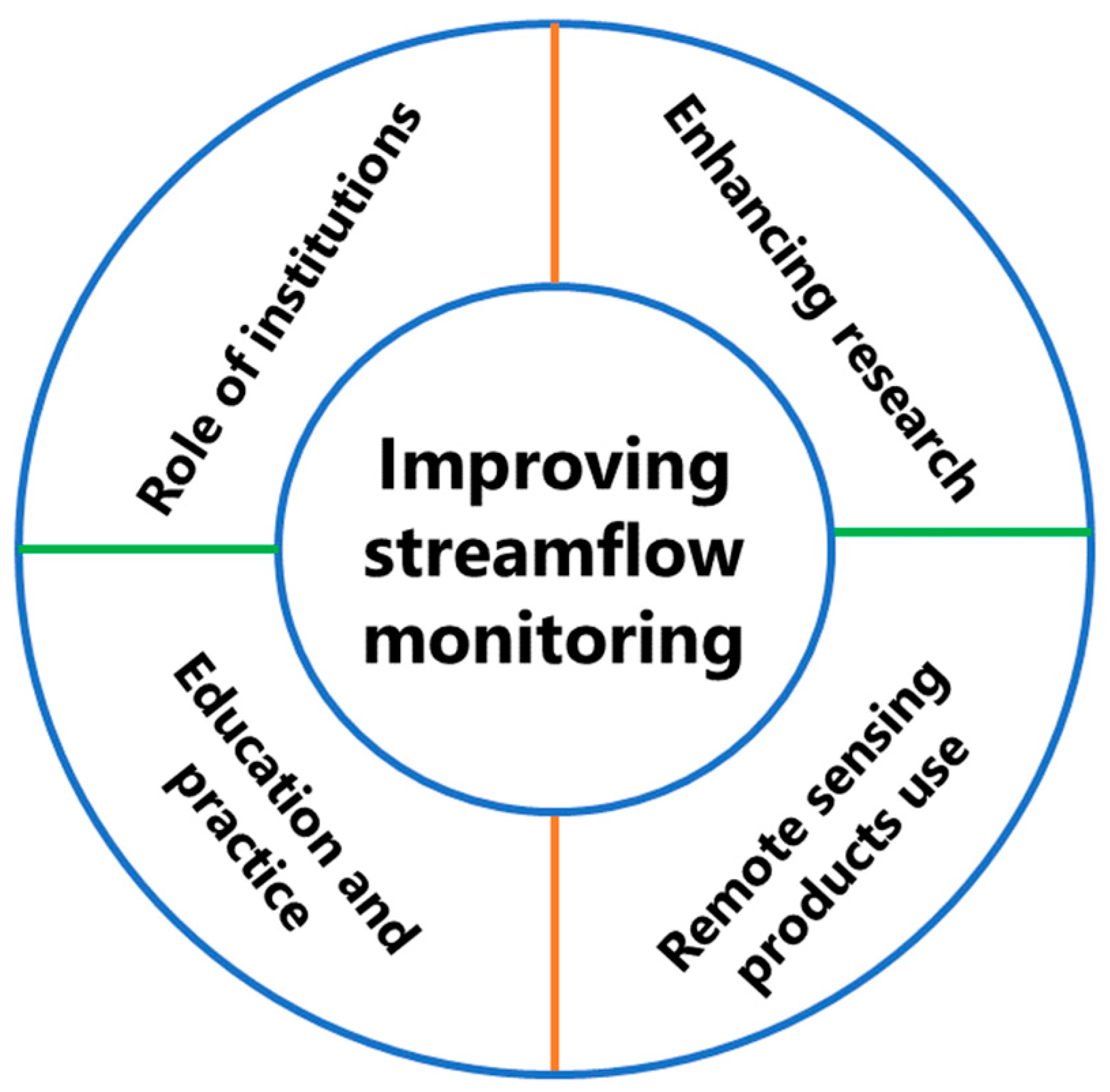
2.1. Workshop-Based Expert Consultation
- Enhancing streamflow monitoring continuity and data availability,
- Realizing the potential of emerging technologies to support streamflow monitoring,
- Integrating education, research, and practice to ensure streamflow data continuity and availability,
- Understanding the role of different institutions that can support streamflow data availability and quality, and
- Finally, identifying research priorities to improve streamflow monitoring and data quality for the scientific community.

Identification of Top Ten Research Priorities
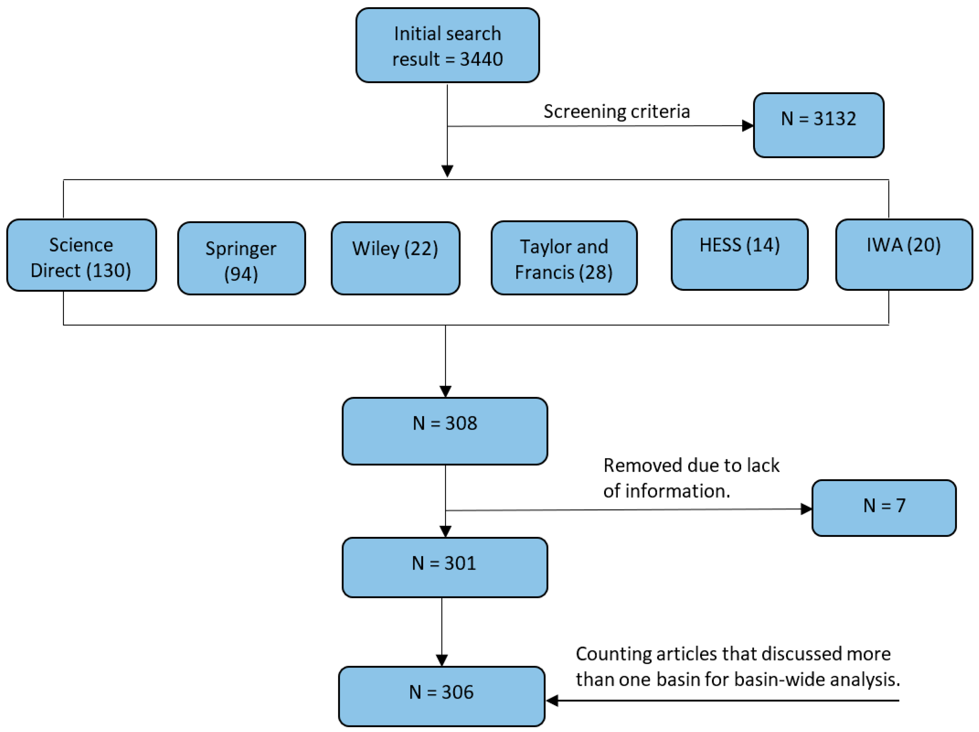
2.2. Literature Review
3. Streamflow Monitoring in Ethiopia—The Workshop Discussion Synthesis
3.1. Research for Streamflow Monitoring
3.1.1. Data Collection
3.1.2. Support Capacity Development
3.2. Revisiting Hydrology Education in Ethiopia
Strengthening University–Industry Linkage
3.3. Remote Sensing for Streamflow Monitoring
Limitations of Remote Sensing—Research Needs
- Increase revisiting time by integrating multiple satellite data sources,
- Enhance remote sensing applicability to small size rivers,
- Research to investigate the comparative advantages of resampling methods,
- Identify satellites with revisit times that enable them to capture salient features of the diurnal cycle of streamflow, and
- Investigate how to overcome the limitations of low-flow measurement.
3.4. Institutional Responsibilities
Co-Production
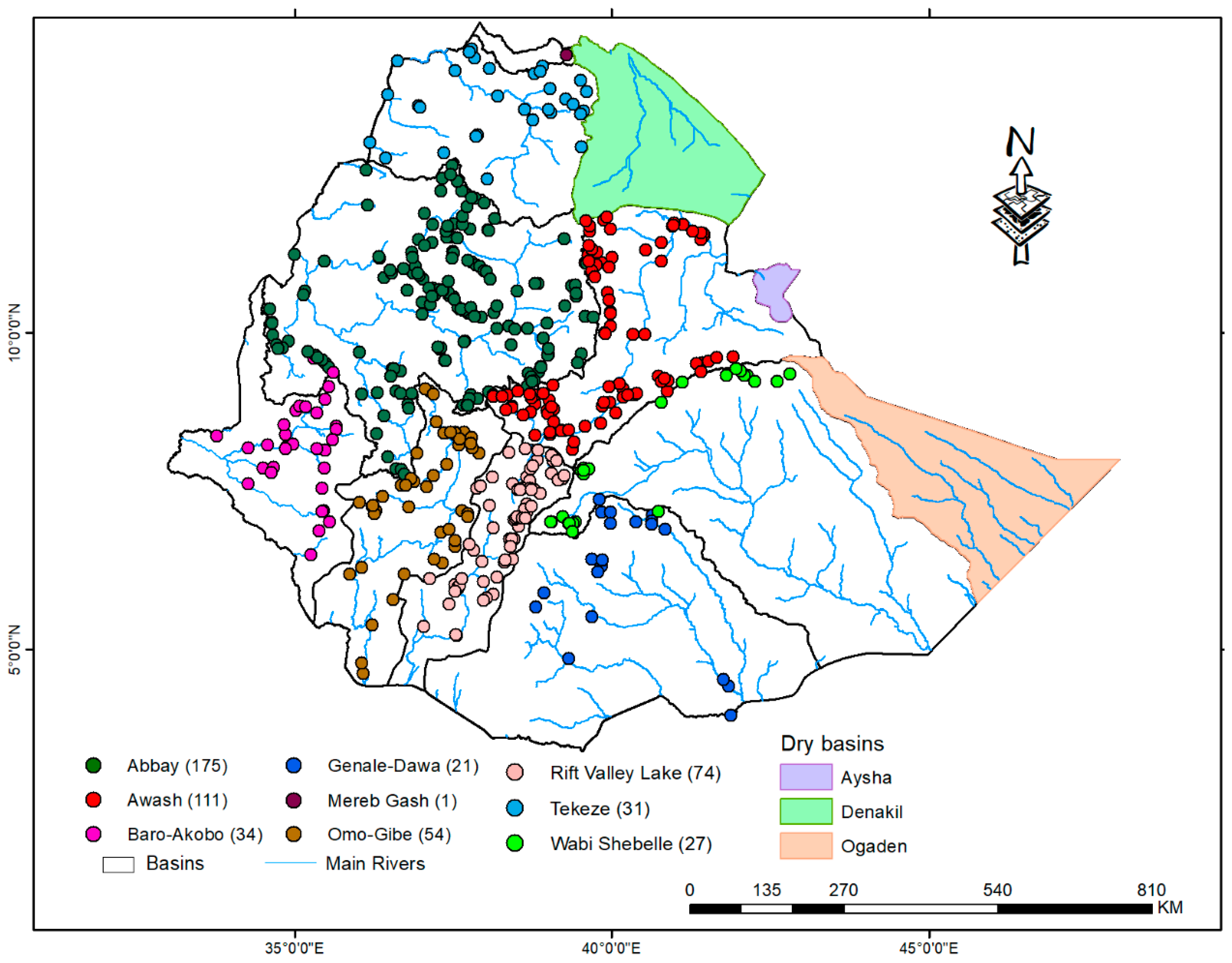
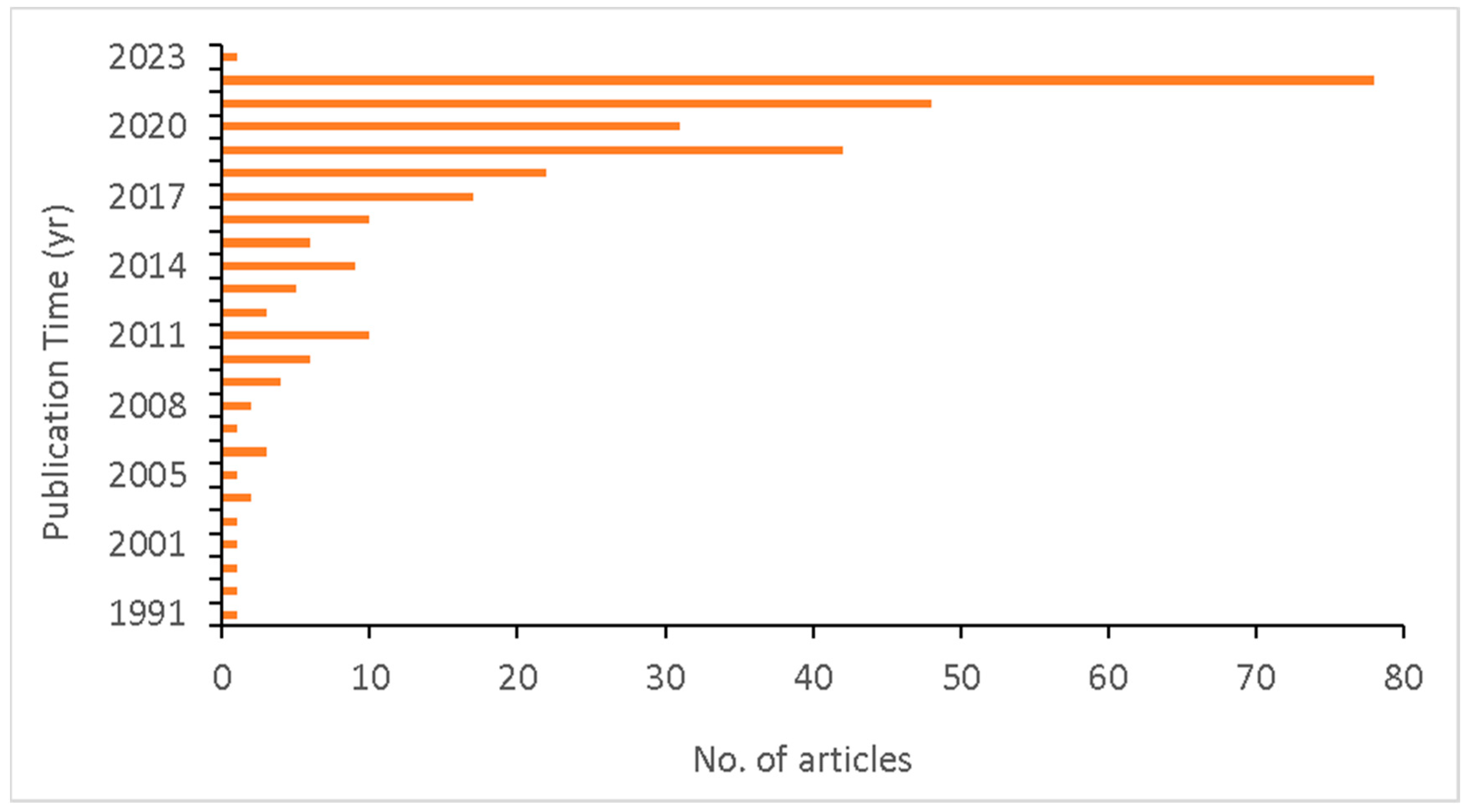
4. Literature Evidence on the Status of Streamflow Monitoring
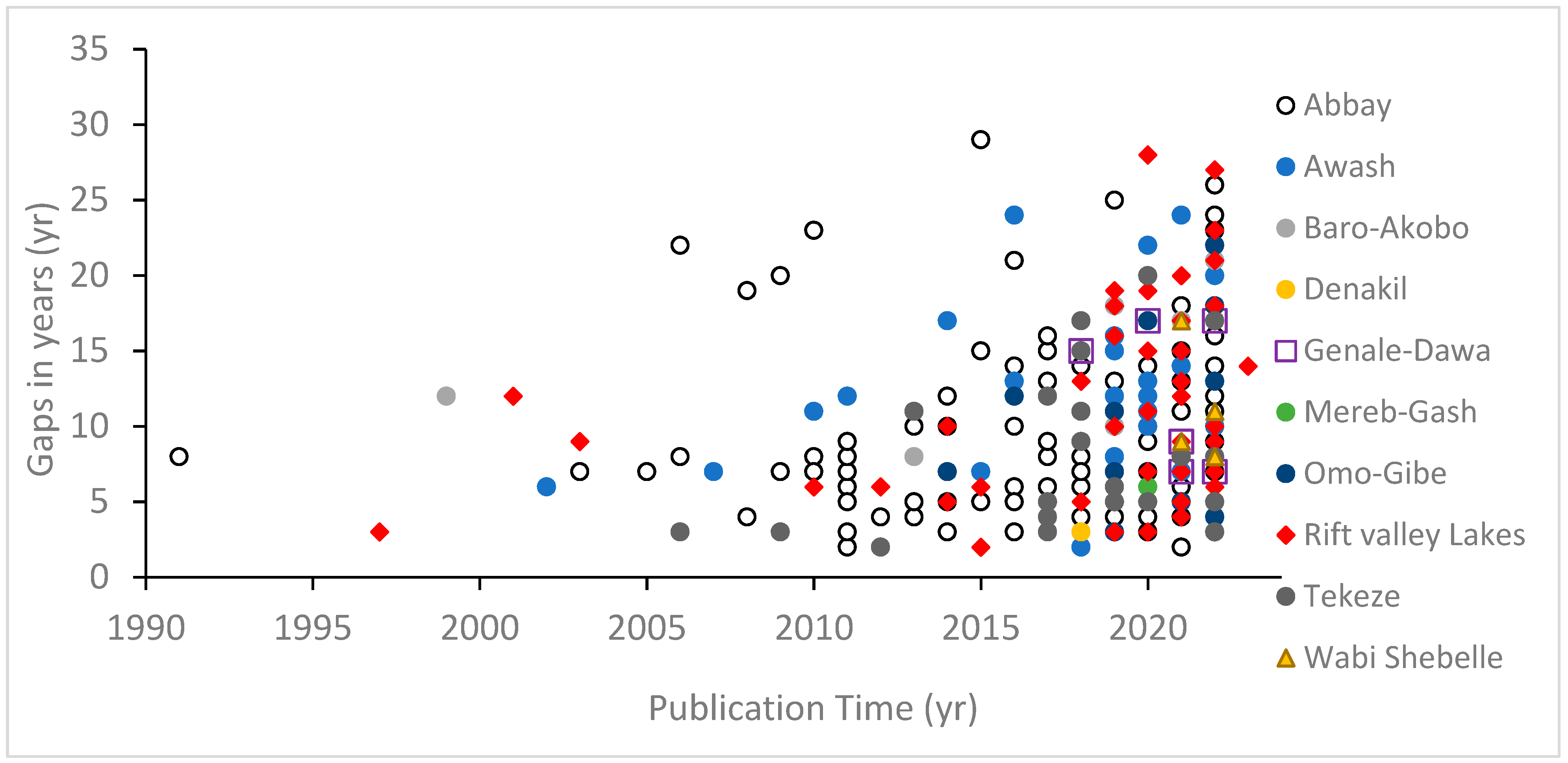
4.1. Data Gaps
4.2. Implication of Streamflow Data Gaps
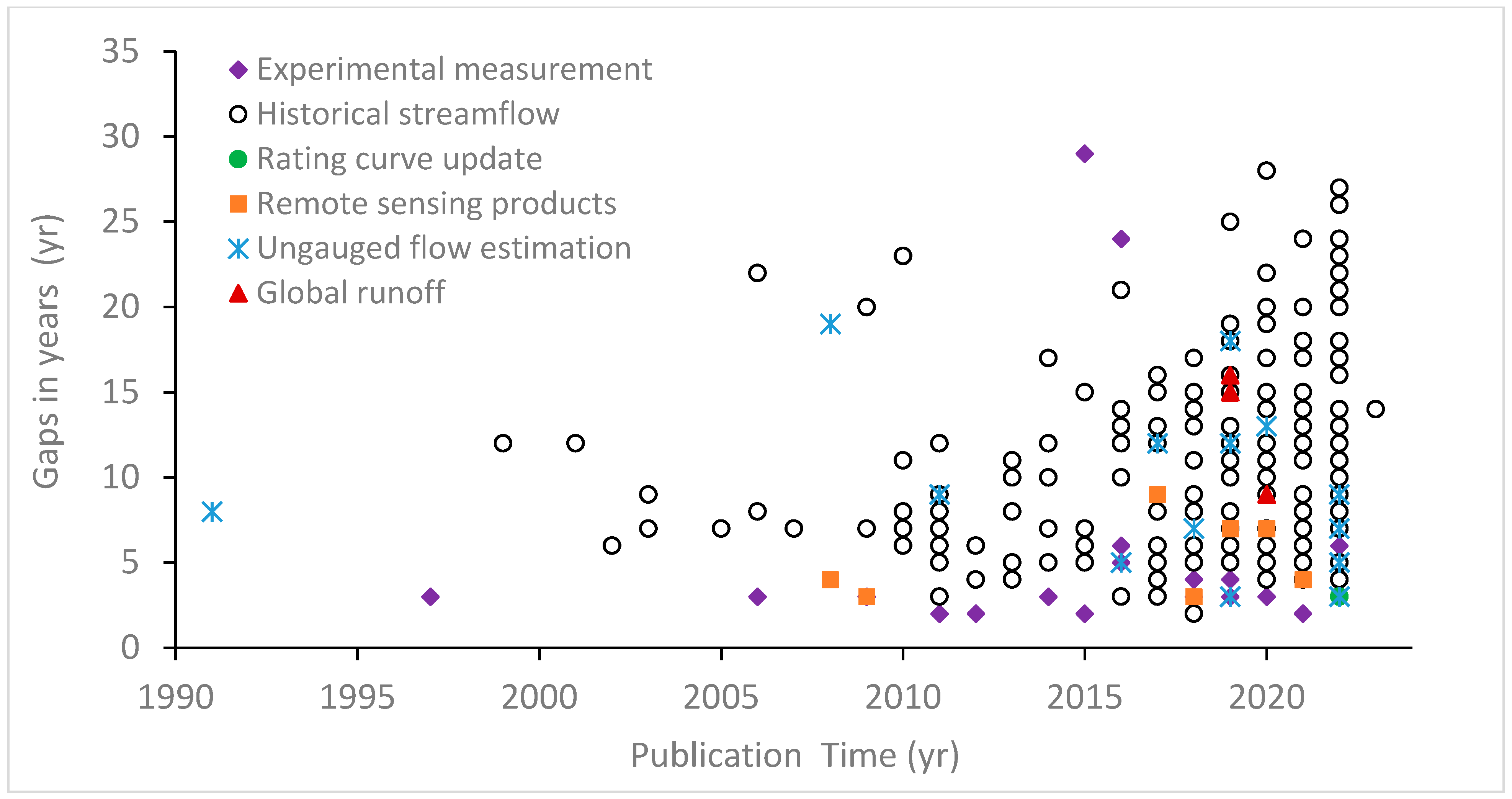
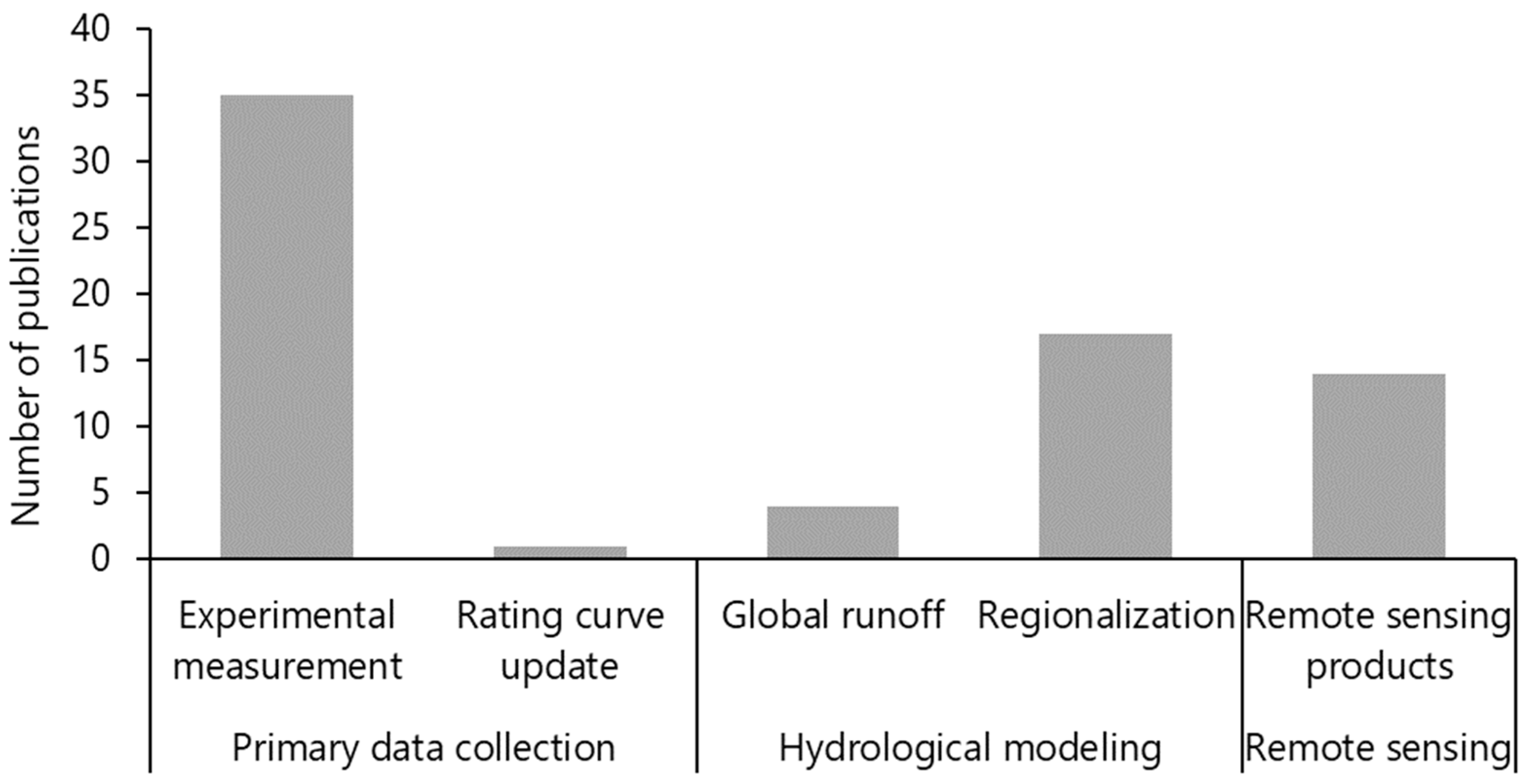
4.3. Current Research Practices to Fill Data Gaps in Ethiopia
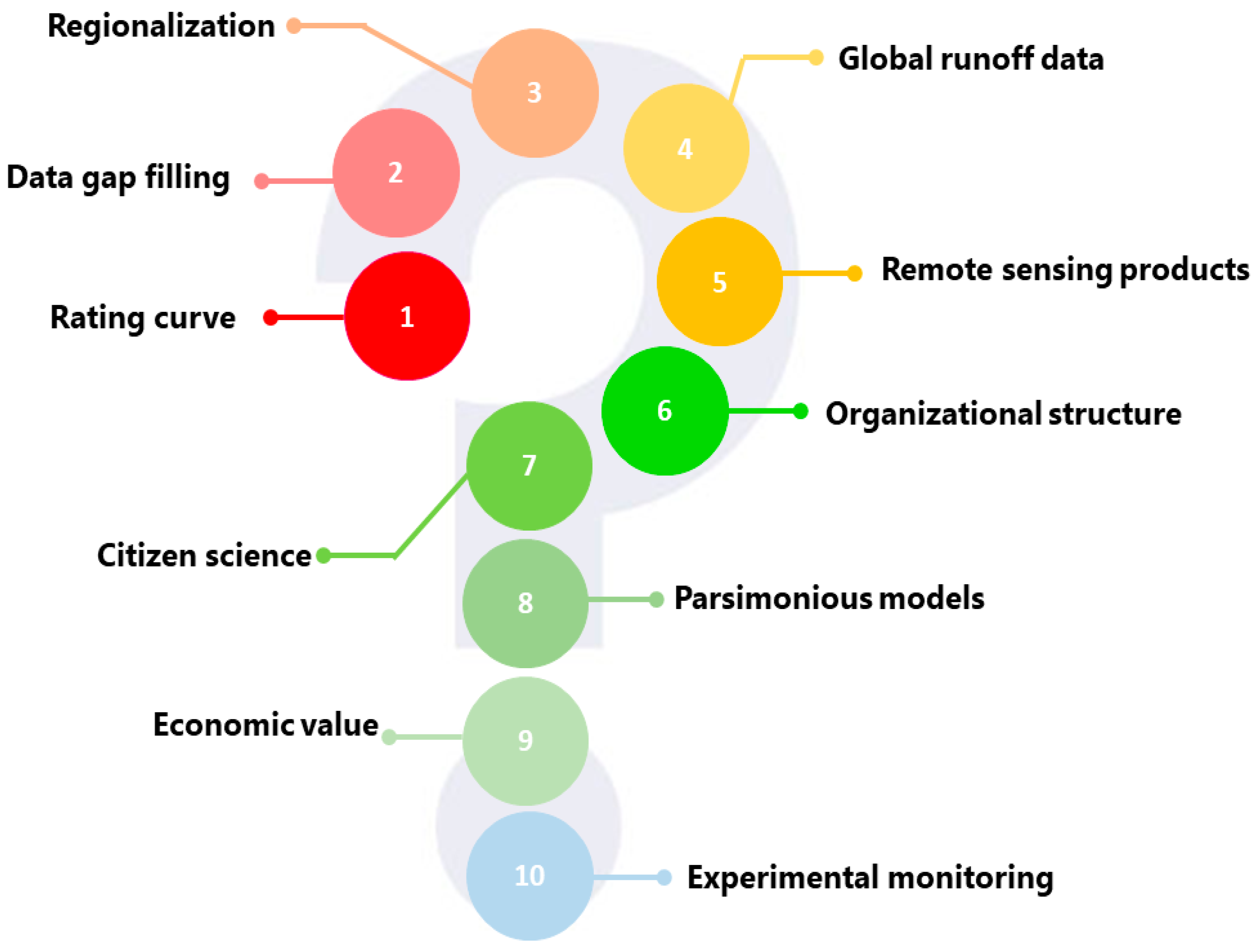
5. Top Ten Research Priorities for Streamflow Data Monitoring in Ethiopia
- Rating curve development, validation, and quantifying uncertainties for limited data.
- Evaluation of streamflow data gap-filling methods and reconstruction of data from missing years.
- Developing regionalized equations for hydrological modeling in ungauged basins.
- Enhance the accuracy of global runoff data by bias correction and merging/blending with historical data to generate locally usable streamflow data.
- Generate streamflow data from multiple remote sensing data sources to enhance spatio-temporal resolution and coverage.
- Assess the implication of the current organizational structure for hydrological service in Ethiopia and suggest alternative and supplementary approaches to enhance its performance.
- Testing the citizen science approach to support streamflow monitoring to show quality data can be collected by citizens and to use this as an opportunity to support monitoring.
- The use and development of parsimonious models to generate streamflow data in data-scarce regions.
- Investigate the economic value of observed streamflow data measurement and maintenance, the implication of using poor-quality data in economic terms, and its general implication for water resource development.
- Experimental monitoring of geomorphology and discharge of selected streamflow gauging sites to develop, calibrate, and validate runoff data from global data and remote sensing.
6. Conclusions
Author Contributions
Funding
Data Availability Statement
Acknowledgments
Conflicts of Interest
Appendix A

| Theme | Thematic Questions |
|---|---|
| Enhanced research to deal with an increasing data deterioration |
|
| Remote sensing use for streamflow monitoring |
|
| Education and practice to improve streamflow monitoring in Ethiopia |
|
| Role of institutions (academic, research, data providers) in hydrological data monitoring and services |
|
| Research priorities in order to sustain streamflow data monitoring in Ethiopia |
|
| Key messages |
|
| Title of the Articles | Year of Publication |
|---|---|
| Does the recent afforestation program in Ethiopia influenced vegetation cover and hydrology? A case study in the upper awash basin, Ethiopia | 2022 |
| Impact of climate change on future precipitation amounts, seasonal distribution, and streamflow in the Omo-Gibe basin, Ethiopia | 2022 |
| Streamflow and sediment yield estimation, and area prioritization for better conservation planning in the Dawe River watershed of the Wabi Shebelle River Basin, Ethiopia | 2021 |
| Comparison and evaluation of gridded precipitation datasets for streamflow simulation in data scarce watersheds of Ethiopia | 2019 |
| Climate change impact assessment on the hydrology of a large river basin in Ethiopia using a local-scale climate modelling approach | 2020 |
| Potential climate change impact assessment on the hydrology of the Lake Tana Basin, Upper Blue Nile River Basin, Ethiopia | 2020 |
| Merging satellite rainfall estimates and daily rain gauge observations for improved flood simulation in MelkaKuntire catchment, upper Awash Basin, Ethiopia | 2022 |
| How suitable are satellite rainfall estimates in simulating high flows and actual evapotranspiration in MelkaKunitre catchment, Upper Awash Basin, Ethiopia? | 2021 |
| Impacts of land use and land cover changes on hydrology of the Gumara catchment, Ethiopia | 2019 |
| Observed and model simulated twenty-first century hydro-climatic change of Northern Ethiopia | 2019 |
| Effects of climate change on water resources in the upper Blue Nile Basin of Ethiopia | 2018 |
| An evidence for enhancing the design hydrograph estimation for small and ungauged basins in Ethiopia | 2022 |
| Climatic controls of ecohydrological responses in the highlands of northern Ethiopia | 2017 |
| Spatial and temporal variability evaluation of sediment yield and sub-basins/hydrologic response units prioritization on Genale Basin, Ethiopia | 2021 |
| Evaluating satellite-based evapotranspiration estimates for hydrological applications in data-scarce regions: A case in Ethiopia | 2020 |
| Hydrological impacts of climate change in selected ungauged sub-watersheds of Lake Tana Sub-Basin, Upper Blue Nile Basin, Ethiopia: A regionalization approach | 2022 |
| Implications of water abstraction on the interconnected Central Rift Valley Lakes sub-basin of Ethiopia using WEAP | 2021 |
| Investigation of non-stationarity in hydro-climatic variables at Rift Valley lakes basin of Ethiopia | 2012 |
| Hydrological responses to land use/cover changes in the source region of the Upper Blue Nile Basin, Ethiopia | 2017 |
| Quantifying sensitivity of groundwater recharge to land use and land cover changes by improving model performance on the wetland dominated Tikur Wuha Watershed, Ethiopia | 2022 |
| Groundwater modeling in data scarce aquifers: The case of Gilgel-Abay, Upper Blue Nile, Ethiopia | 2020 |
| Multi-site calibration of hydrological model and the response of water balance components to land use land cover change in a rift valley Lake Basin in Ethiopia | 2022 |
| Modeling the impact of climate change on hydrological responses in the Lake Tana basin, Ethiopia | 2022 |
| Modeling projected impacts of climate and land use/land cover changes on hydrological responses in the Lake Tana Basin, upper Blue Nile River Basin, Ethiopia | 2021 |
| Streamflow variability and its linkage to ENSO events in the Ethiopian Rift Valley Lakes Basin | 2021 |
| Effect of irrigation water withdrawal on the hydrology of the Lake Tana sub-basin | 2021 |
| Rainfall-runoff modeling using HEC-HMS model for Meki river watershed, rift valley basin, Ethiopia | 2023 |
| Water balance components of the potential agricultural grabens along the Rift Valley in northern Ethiopia | 2019 |
| Curve number calibration for measuring impacts of land management in sub-humid Ethiopia | 2021 |
| Climate-induced flood inundation in Fogera-Dera Floodplain, Lake Tana basin, Ethiopia | 2019 |
| Modelling hydrological processes under climate change scenarios in the Jemma sub-basin of upper Blue Nile Basin, Ethiopia | 2021 |
| Reduced runoff and sediment loss under alternative land capability-based land use and management options in a sub-humid watershed of Ethiopia | 2022 |
| Regionalization of catchments for flood frequency analysis for data scarce Rift Valley Lakes Basin, Ethiopia | 2022 |
| Attributing the hydrological impact of different land use types and their long-term dynamics through combining parsimonious hydrological modelling, alteration analysis and PLSR analysis | 2019 |
| Impacts of Climate and Land Use Change on Hydrological Response in Gumara Watershed, Ethiopia | 2021 |
| Investigation of runoff response to land use/land cover change on the case of Aynalem catchment, North of Ethiopia | 2019 |
| Performance of bias corrected MPEG rainfall estimate for rainfall-runoff simulation in the upper Blue Nile Basin, Ethiopia | 2018 |
| Climate change impacts on water resources in the Upper Blue Nile (Abay) River Basin, Ethiopia | 2021 |
| Evaluation of observed and satellite-based climate products for hydrological simulation in data-scarce Baro-Akobo River Basin, Ethiopia | 2022 |
| Evaluation of lag time and time of concentration estimation methods in small tropical watersheds in Ethiopia | 2022 |
| Modeling of sediment yield in Maybar gauged watershed using SWAT, northeast Ethiopia | 2015 |
| Three-dimensional groundwater flow modeling to assess the impacts of the increase in abstraction and recharge reduction on the groundwater, groundwater availability and groundwater-surface waters interaction: A case of the rib catchment in the Lake Tana sub-basin of the Upper Blue Nile River, Ethiopia | 2021 |
| SWAT and HBV models’ response to streamflow estimation in the upper Blue Nile Basin, Ethiopia | 2021 |
| Climate change and the response of streamflow of watersheds under the high emission scenario in Lake Tana sub-basin, upper Blue Nile basin, Ethiopia | 2022 |
| Analysis of rainfall and streamflow trend and variability over Birr River watershed, Abbay basin, Ethiopia | 2022 |
| Hydrologic response to land use land cover change in the Upper Gidabo Watershed, Rift Valley Lakes Basin, Ethiopia | 2020 |
| Effect of spatial scale on runoff coefficient: Evidence from the Ethiopian highlands | 2018 |
| Analyzing the variability of sediment yield: A case study from paired watersheds in the Upper Blue Nile basin, Ethiopia | 2018 |
| Is observation uncertainty masking the signal of land use change impacts on hydrology? | 2019 |
| Effects of land use on catchment runoff and soil loss in the sub-humid Ethiopian highlands | 2017 |
| Hydro-meteorological trends in the Gidabo catchment of the Rift Valley Lakes Basin of Ethiopia | 2018 |
| Sediment Yield Estimation and Effect of Management Options on Sediment Yield of Kesem Dam Watershed, Awash Basin, Ethiopia | 2020 |
| Application of CORDEX-AFRICA and NEX-GDDP datasets for hydrologic projections under climate change in Lake Ziway sub-basin, Ethiopia | 2020 |
| Modeling blue and green water resources availability at the basin and sub-basin level under changing climate in the Weyb River basin in Ethiopia | 2020 |
| Impact of climate change on groundwater recharge and base flow in the sub-catchment of Tekeze basin, Ethiopia | 2018 |
| Satellite-based rainfall estimates evaluation using a parsimonious hydrological model in the complex climate and topography of the Nile River Catchments | 2022 |
| Simulated surface and shallow groundwater resources in the Abaya-Chamo Lake basin, Ethiopia using a spatially-distributed water balance model | 2019 |
| Comprehensive hydrological and hydrogeological study of topographically closed lakes in highland Ethiopia: The case of Hayq and Ardibo | 2007 |
| Application of ANN and HEC-RAS model for flood inundation mapping in lower Baro Akobo River Basin, Ethiopia | 2021 |
| Impact of landscape pattern changes on hydrological ecosystem services in the Beressa watershed of the Blue Nile Basin in Ethiopia | 2021 |
| Evaluation of climate anomalies impacts on the Upper Blue Nile Basin in Ethiopia using a distributed and a lumped hydrologic model | 2015 |
| Prioritization of watershed management scenarios under climate change in the Jemma sub-basin of the Upper Blue Nile Basin, Ethiopia | 2020 |
| Hydrological evaluation of open-access precipitation and air temperature datasets using SWAT in a poorly gauged basin in Ethiopia | 2019 |
| Recharge variability and sensitivity to climate: The example of Gidabo River Basin, Main Ethiopian Rift | 2015 |
| Assessing the effect of water harvesting techniques on event-based hydrological responses and sediment yield at a catchment scale in northern Ethiopia using the Limburg Soil Erosion Model (LISEM) | 2017 |
| Identifying sustainability challenges on land and water uses: The case of Lake Ziway watershed, Ethiopia | 2017 |
| SWAT based hydrological assessment and characterization of Lake Ziway sub-watersheds, Ethiopia | 2017 |
| Dynamics of land use land cover and resulting surface runoff management for environmental flood hazard mitigation: The case of Dire Daw city, Ethiopia | 2019 |
| Hydrological responses to land use/land cover change and climate variability in contrasting agro-ecological environments of the Upper Blue Nile basin, Ethiopia | 2019 |
| Spatial mapping and testing the applicability of the curve number method for ungauged catchments in Northern Ethiopia | 2017 |
| Modeling the hydrological impacts of land use/land cover changes in the Andassa watershed, Blue Nile Basin, Ethiopia | 2018 |
| Regional flood frequency curves for remote rural areas of the Nile River Basin: The case of Baro-Akobo drainage basin, Ethiopia | 2019 |
| Impacts of land use/land cover change on stream flow and sediment yield of Gojeb watershed, Omo-Gibe basin, Ethiopia | 2019 |
| Hydrological performance evaluation of multiple satellite precipitation products in the upper Blue Nile basin, Ethiopia | 2020 |
| Precipitation and streamflow variability in Tekeze River basin, Ethiopia | 2019 |
| Effects of the floodplain on river discharge into Lake Tana (Ethiopia) | 2014 |
| Application of parameter estimation and regionalization methodologies to ungauged basins of the Upper Blue Nile River Basin, Ethiopia | 2008 |
| Evaluation of CFSR, TMPA 3B42 and ground-based rainfall data as input for hydrological models, in data-scarce regions: The upper Blue Nile Basin, Ethiopia | 2017 |
| Application of a spatially distributed water balance model for assessing surface water and groundwater resources in the Geba basin, Tigray, Ethiopia | 2013 |
| Disentangling the impacts of climate change, land use change and irrigation on the Central Rift Valley water system of Ethiopia | 2014 |
| Determinants of peak discharge in steep mountain catchments—Case of the Rift Valley escarpment of Northern Ethiopia | 2015 |
| Effects of check dams on runoff characteristics along gully reaches, the case of Northern Ethiopia | 2017 |
| Built Environment, flooding regime change, and its effect on adaptation to climate change in the cities of developing countries: Learning a lesson from Addis Ababa City, Ethiopia | 2019 |
| Flood hazard mapping using FLO-2D and local management strategies of Dire Dawa city, Ethiopia | 2018 |
| The impact of climate change on mean and extreme state of hydrological variables in Megech watershed, Upper Blue Nile Basin, Ethiopia | 2019 |
| Effect of land use land cover dynamics on hydrological response of watershed: Case study of Tekeze Dam watershed, northern Ethiopia | 2017 |
| Combined uncertainty of hydrological model complexity and satellite-based forcing data evaluated in two data-scarce semi-arid catchments in Ethiopia | 2014 |
| Predicting streamflow for land cover changes in the Upper Gilgel Abay River Basin, Ethiopia: A TOPMODEL based approach | 2014 |
| Estimating the effect of climate change on water resources: Integrated use of climate and hydrological models in the Werii watershed of the Tekeze river basin, Northern Ethiopia | 2018 |
| Evaluating InVEST model for estimating soil loss and sediment export in data scarce regions of the Abbay (Upper Blue Nile) Basin: Implications for land managers | 2021 |
| Hydro-climatic trends in the Abay/Upper Blue Nile basin, Ethiopia | 2013 |
| Runoff on slopes with restoring vegetation: A case study from the Tigray highlands, Ethiopia | 2006 |
| Evaluation of the Hyper-Resolution Model-Derived Water Cycle Components Over the Upper Blue Nile Basin | 2020 |
| Impact of conservation agriculture on catchment runoff and soil loss under changing climate conditions in May Zeg-zeg (Ethiopia) | 2012 |
| Probabilistic characterization of hydrological droughts in the Blue Nile River, Ethiopia | 2019 |
| Evaluating the applicability and scalability of bias corrected CFSR climate data for hydrological modeling in upper Blue Nile basin, Ethiopia | 2019 |
| Upper Blue Nile basin water budget from a multi-model perspective | 2017 |
| How well do gridded precipitation and actual evapotranspiration products represent the key water balance components in the Nile Basin? | 2021 |
| Hydrological response of a catchment to climate and land use changes in Tropical Africa: case study South Central Ethiopia | 2003 |
| Hydrologic response to cattle grazing in the Ethiopian highlands | 1997 |
| Combined 3D hydrodynamic and watershed modelling of Lake Tana, Ethiopia | 2011 |
| Runoff and sediment-associated nutrient losses under different land uses in Tigray, Northern Ethiopia | 2009 |
| Flooding and sustainable land–water management in the lower Baro–Akobo river basin, Ethiopia | 1999 |
| Lake evaporation estimates in tropical Africa (Lake Ziway, Ethiopia) | 2001 |
| Spatial and temporal simulation of groundwater recharge and cross-validation with point estimations in volcanic aquifers with variable topography | 2022 |
| Evaluation of satellite rainfall products for modeling water yield over the source region of Blue Nile Basin | 2020 |
| Impacts of projected change in climate on water balance in basins of East Africa | 2019 |
| Impact of land use and land cover dynamics on ecologically-relevant flows and blue-green water resources | 2022 |
| Sediment balances in the Blue Nile River Basin | 2014 |
| Evaluating hydrologic responses to soil characteristics using SWAT model in a paired-watersheds in the Upper Blue Nile Basin | 2018 |
| Evaluating runoff and sediment responses to soil and water conservation practices by employing alternative modeling approaches | 2020 |
| Groundwater recharge estimation using empirical methods from rainfall and streamflow records | 2021 |
| Trend analysis of runoff and sediment fluxes in the Upper Blue Nile basin: A combined analysis of statistical tests, physically-based models and landuse maps | 2013 |
| Revisiting storm runoff processes in the upper Blue Nile basin: The Debre Mawi watershed | 2016 |
| Hydrological modeling, impact of land-use and land-cover change on hydrological process and sediment yield; case study in Jedeb and Chemoga watersheds | 2022 |
| Prediction of sedimentation in reservoirs by combining catchment based model and stream based model with limited data | 2019 |
| Identifying sources of temporal variability in hydrological extremes of the upper Blue Nile basin | 2013 |
| Assessing the implications of water harvesting intensification on upstream–downstream ecosystem services: A case study in the Lake Tana basin | 2016 |
| Hydrological evaluation of satellite-based rainfall estimates over the Volta and Baro-Akobo Basin | 2013 |
| Comparison of hydrological models for the assessment of water resources in a data-scarce region, the Upper Blue Nile River Basin | 2017 |
| Simulation of streamflows for ungauged catchments | 1991 |
| The response of water balance components to land cover change based on hydrologic modeling and partial least squares regression (PLSR) analysis in the Upper Awash Basin | 2019 |
| Flood Risk and Vulnerability of Addis Ababa City Due to Climate Change and Urbanization | 2016 |
| Evaluation of globally available water resources reanalysis (WRR-1) runoff products for assessment and management water resources in the Upper Blue Nile basin: A data scarce major subbasins of the Nile basin | 2019 |
| Assessment of catchment water resources availability under projected climate change scenarios and increased demand in Central Rift Valley Basin | 2019 |
| Influence of climate variability on representative QDF predictions of the upper Blue Nile basin | 2011 |
| Modelling ungauged catchments using the catchment runoff response similarity | 2018 |
| Characterizing water storage trends and regional climate influence using GRACE observation and satellite altimetry data in the Upper Blue Nile River Basin | 2018 |
| Climate Change Impact on the Hydrology of Tekeze Basin, Ethiopia: Projection of Rainfall-Runoff for Future Water Resources Planning | 2018 |
| Evaluation of the WEAP model in simulating subbasin hydrology in the Central Rift Valley basin, Ethiopia | 2021 |
| The impacts of LULC and climate change scenarios on the hydrology and sediment yield of Rib watershed, Ethiopia | 2022 |
| Land Use/Cover Change Impacts on Hydrology Using SWAT Model on Borkena Watershed, Ethiopia | 2022 |
| Modeling Climate Change Impact on the Hydrology of Keleta Watershed in the Awash River Basin, Ethiopia | 2019 |
| Evaluation of streamflow response to climate change in the data-scarce region, Ethiopia | 2022 |
| A scenario-based modeling of climate change impact on the hydrology of Ketar watershed, Central Rift Valley Basin, Ethiopia | 2022 |
| Land Use and Climate Change Impacts on Streamflow Using SWAT Model, Middle Awash Sub Basin, Ethiopia | 2022 |
| Evaluating the dynamics of hydroclimate and streamflow for data-scarce areas using MIKE11-NAM model in Bilate river basin, Ethiopia | 2022 |
| Application of ANN-Based Streamflow Forecasting Model for Agricultural Water Management in the Awash River Basin, Ethiopia | 2011 |
| Hydrological responses to land use/land cover change in Tikur Wuha Watershed in Southern Ethiopia | 2022 |
| Model parameter transfer for streamflow and sediment loss prediction with SWAT in a tropical watershed | 2016 |
| Analysis and Characterization of Hydrological Drought Under Future Climate Change Using the SWAT Model in Tana Sub-basin, Ethiopia | 2022 |
| Streamflow response to climate change in the Greater Horn of Africa | 2019 |
| Streamflow prediction uncertainty analysis and verification of SWAT model in a tropical watershed | 2016 |
| Stream flow modeling using SWAT model and the model performance evaluation in Toba sub-watershed, Ethiopia | 2021 |
| The dual impact of climate change on irrigation water demand and reservoir performance: a case study of Koga irrigation scheme, Ethiopia | 2022 |
| Hydro-meteorological impact assessment of climate change on Tikur Wuha watershed in Ethiopia | 2021 |
| Modeling the impact of climate change on the hydrology of Andasa watershed | 2022 |
| Multi-variable calibration of hydrological model in the upper Omo-Gibe basin, Ethiopia | 2020 |
| Modeling Hydrological Responses to Land Use Dynamics, Choke, Ethiopia | 2019 |
| Stochastic Forecasting Models of the Monthly Streamflow for the Blue Nile at Eldiem Station | 2018 |
| Impact of water resource development plan on water abstraction and water balance of Lake Ziway, Ethiopia | 2021 |
| Drought Analysis in the Awash River Basin, Ethiopia | 2010 |
| Optimal surface water allocation under various scenarios in the Central Rift Valley basin in Ethiopia | 2022 |
| Impact of climate change on surface water availability and crop water demand for the sub-watershed of Abbay Basin, Ethiopia | 2019 |
| Trend and variability of hydrometeorological variables of Tikur Wuha watershed in Ethiopia | 2020 |
| Climate Change Induced Precipitation and Temperature Effects on Water Resources: the Case of Borkena Watershed in the Highlands of Wollo, Central Ethiopia | 2020 |
| Surface runoff modeling using SWAT analysis in Dabus watershed, Ethiopia | 2021 |
| Modeling runoff-sediment influx responses to alternative BMP interventions in the Gojeb watershed, Ethiopia, using the SWAT hydrological model | 2022 |
| Land use and land cover change dynamics and its impact on watershed hydrological parameters: the case of Awetu watershed, Ethiopia | 2022 |
| WEAP modeling of surface water resources allocation in Didessa Sub-Basin, West Ethiopia | 2016 |
| Modeling runoff and sediment yield of Kesem dam watershed, Awash basin, Ethiopia | 2019 |
| Impacts of climate change on water balance components of Guder Catchment, Upper Abbay Basin, Ethiopia: SWAT model | 2022 |
| Assessment of run-of-river hydropower potential in the data-scarce region, Omo-Gibe Basin, Ethiopia | 2022 |
| Evaluation of Global Water Resources Reanalysis Runoff Products for Local Water Resources Applications: Case Study-Upper Blue Nile Basin of Ethiopia | 2020 |
| Evaluation of SWAT performance in modeling nutrients of Awash River basin, Ethiopia | 2019 |
| Modeling future flood frequency under CMIP5 Scenarios in Hare watershed, Southern Rift Valley of Ethiopia | 2021 |
| Multi-site multi-objective calibration of SWAT model using a large dataset for improved performance in Ethiopia | 2022 |
| Prediction of flood frequency under a changing climate, the case of Hare watershed, Rift Valley Basin of Ethiopia | 2021 |
| Exploring future global change-induced water imbalances in the Central Rift Valley Basin, Ethiopia | 2021 |
| Enhancing the Forecasting of Monthly Streamflow in the Main Key Stations of the River Nile Basin | 2018 |
| Integrated water resources management under climate change scenarios in the sub-basin of Abaya-Chamo, Ethiopia | 2018 |
| Flood hazard mapping under a climate change scenario in a Ribb catchment of Blue Nile River basin, Ethiopia | 2019 |
| A compendious approach for renewable energy assessment based on satellite and ground truth data: Bilate catchment, Rift Valley Basin, Ethiopia | 2022 |
| Evaluation of rainfall -runoff and suspended sediment concentration in the semi-arid Ethiopian highlands, Tekeze Basin, Ethiopia | 2022 |
| Performance assessment of SWAT and HEC-HMS model for runoff simulation of Toba watershed, Ethiopia | 2021 |
| Assessment of the impact of climate change on surface hydrological processes using SWAT: a case study of Omo-Gibe river basin, Ethiopia | 2016 |
| Stream flow dynamics under current and future land cover conditions in Atsela Watershed, Northern Ethiopia | 2022 |
| Evaluating the Effectiveness of Best Management Practices On Soil Erosion Reduction Using the SWAT Model: for the Case of Gumara Watershed, Abbay (Upper Blue Nile) Basin | 2021 |
| Climate change impacts analysis on hydrological processes in the Weyib River basin in Ethiopia | 2018 |
| Ethiopia’s Water Resources: An Assessment Based on Geospatial Data-Driven Distributed Hydrological Modeling Approach | 2022 |
| Hydrological impacts of climate change in gauged sub-watersheds of Lake Tana sub-basin (Gilgel Abay, Gumara, Megech, and Ribb) watersheds, Upper Blue Nile Basin, Ethiopia | 2022 |
| Detection of trends in hydrological extremes for Ethiopian watersheds, 1975 to 2010 | 2019 |
| Groundwater Potential Mapping Using SWAT and GIS-Based Multi-Criteria Decision Analysis | 2020 |
| Effect of land use/land cover change on the regimes of surface runoff: the case of Lake Basaka catchment (Ethiopia) | 2019 |
| Sediment Yield Modeling and Evaluation of Best Management Practices Using the SWAT Model of the Daketa Watershed, Ethiopia | 2022 |
| Impact of land use/land cover change on stream flow in the Shaya catchment of Ethiopia using the MIKE SHE model | 2021 |
| Regionalization of mean annual flow for ungauged catchments in case of Abbay River Basin, Ethiopia | 2021 |
| Development of hybrid baseflow prediction model by integrating analytical method with deep learning | 2022 |
| Assessment of consumption and availability of water in the upper Omo-Gibe basin, Ethiopia | 2019 |
| Assessment of climate change impact on hydro-climatic variables and its trends over Gidabo Watershed | 2022 |
| Understanding Catchments Hydrologic Response Similarity of Upper Blue Nile (Abay) basin through catchment classification | 2022 |
| Application of hydrodynamic models for designing structural measures for river flood mitigation: the case of Kulfo River in southern Ethiopia | 2021 |
| Evaluation of Water Provision Ecosystem Services Associated with Land Use/Cover and Climate Variability in the Winike Watershed, Omo Gibe Basin of Ethiopia | 2022 |
| Current and projected water demand and water availability estimates under climate change scenarios in the Weyib River basin in Bale mountainous area of Southeastern Ethiopia | 2018 |
| Modelling hydrological response under climate change scenarios using SWAT model: the case of Ilala watershed, Northern Ethiopia | 2018 |
| Hydrological modeling in the Upper Blue Nile basin using soil and water analysis tool (SWAT) | 2022 |
| Efficiency of soil and water conservation practices in different agro-ecological environments in the Upper Blue Nile Basin of Ethiopia | 2018 |
| Modeling the rainfall-runoff using MIKE 11 NAM model in Shaya catchment, Ethiopia | 2021 |
| Rainfall variability and its influence on surface flow regimes examples from the central highlands of Ethiopia | 2002 |
| Comparison of HEC-HMS hydrologic model for estimation of runoff computation techniques as a design input: case of Middle Awash multi-purpose dam, Ethiopia | 2022 |
| A modeling approach for evaluating the impacts of Land Use/Land Cover change for Ziway Lake Watershed hydrology in the Ethiopian Rift | 2022 |
| Assessment of the effects of agricultural management practices on soil erosion and sediment yield in Rib watershed, Ethiopia | 2022 |
| Characteristics of hydrological extremes in Kulfo River of Southern Ethiopian Rift Valley Basin | 2020 |
| Prioritization of sediment yield at sub-watershed level using swat model in Fincaha watershed, Abay Basin, Ethiopia | 2022 |
| Suitability of global precipitation estimates for hydrologic prediction in the main watersheds of Upper Awash basin | 2020 |
| Assessment of the spatial and temporal distribution of groundwater recharge in data-scarce large-scale African river basin | 2022 |
| Assessment of water resource and forecasting water demand using WEAP model in Beles river, Abbay river basin, Ethiopia | 2022 |
| Analysis of ambo water supply source diversion weir sedimentation and assessing impact of land management practice through hydrological studies | 2020 |
| Evaluating InVEST model for simulating annual and seasonal water yield in data-scarce regions of the Abbay (Upper Blue Nile) Basin: implications for water resource planners and managers | 2022 |
| Assessment of hydro-meteorological regimes of gidabo river basin under representative concentration pathway scenarios | 2022 |
| Evaluation of TRMM 3B42V7 and CHIRPS Satellite Precipitation Products as an Input for Hydrological Model over Eastern Nile Basin | 2020 |
| Impacts of climate change on stream flow and water availability in Anger sub-basin, Nile Basin of Ethiopia | 2019 |
| GIS-Based Multi-criteria Approach Surface Irrigation Potential Assessment for Ethiopian River Basin: in Case of Upper Awash River Basin | 2022 |
| Climate change impact on extreme precipitation and peak flood magnitude and frequency: observations from CMIP6 and hydrological models | 2022 |
| Modelling of river flow in ungauged catchment using remote sensing data: application of the empirical (SCS-CN), Artificial Neural Network (ANN) and Hydrological Model (HEC-HMS) | 2019 |
| Assessment of the impact of climate change on future hydropower production from Koka Reservoir under two representative concentration pathways (RCP) emission scenarios | 2018 |
| Modeling multivariate standardized drought index based on the drought information from precipitation and runoff: a case study of Hare watershed of Southern Ethiopian Rift Valley Basin | 2021 |
| Analyzing the hydrologic effects of region-wide land and water development interventions: a case study of the Upper Blue Nile basin | 2016 |
| Biohydrology of low flows in the humid Ethiopian highlands: The Gilgel Abay catchment | 2014 |
| Runoff and suspended sediment yield and implications for watershed management | 2022 |
| Ensemble data-driven rainfall-runoff modeling using multi-source satellite and gauge rainfall data input fusion | 2021 |
| Effects of Different Retention Parameter Estimation Methods on the Prediction of Surface Runoff Using the SCS Curve Number Method | 2014 |
| Impact of climate change on the hydroclimatology of Lake Tana Basin, Ethiopia | 2011 |
| Dynamics in land cover and its effect on stream flow in the Chemoga watershed, Blue Nile basin, Ethiopia | 2005 |
| Model-Based Characterization and Monitoring of Runoff and Soil Erosion in Response to Land Use/land Cover Changes in the Modjo Watershed, Ethiopia | 2015 |
| Partitioning the impacts of land use/land cover change and climate variability on water supply over the source region of the Blue Nile Basin | 2020 |
| Modeling of Sediment Yield From Anjeni-Gauged Watershed, Ethiopia Using SWAT Model | 2010 |
| Trends in rainfall and runoff in the Blue Nile Basin: 1964–2003 | 2010 |
| Recession flow analysis of the Blue Nile River | 2003 |
| Change in low flows due to catchment management dynamics—Application of a comparative modelling approach | 2020 |
| El Niño Southern Oscillation link to the Blue Nile River Basin hydrology | 2009 |
| Land Use/Land Cover Changes and Associated Impacts on Water Yield Availability and Variations in the Mereb-Gash River Basin in the Horn of Africa | 2020 |
| Estimation of evaporation over the upper Blue Nile basin by combining observations from satellites and river flow gauges | 2016 |
| The role of input and hydrological parameters uncertainties in extreme hydrological simulations | 2022 |
| The Role of Global Data Sets for Riverine Flood Risk Management at National Scales | 2022 |
| Using the Climate Forecast System Reanalysis as weather input data for watershed models | 2014 |
| Temporal and spatial dynamics of surface run-off from Lake Basaka catchment (Ethiopia) using SCS-CN model coupled with remote sensing and GIS | 2020 |
| Sediment Loss Patterns in the Sub-Humid Ethiopian Highlands | 2017 |
| Intra-Annual Variation of High and Low-Flow Extremes Associated With Land Use and Climate Change in the Upper Tekeze of the Nile River Basin | 2022 |
| Temporal variability of hydroclimatic extremes in the Blue Nile basin | 2012 |
| Climate Change Impacts on Water Resources in the Upper Blue Nile River Basin, Ethiopia | 2009 |
| Water balance dynamics in the Nile Basin | 2009 |
| Investigation of the Curve Number Method For Surface Runoff Estimation In Tropical Regions | 2016 |
| Rainfall-runoff modelling using artificial neural networks technique: a Blue Nile catchment case study | 2006 |
| Error propagation of climate model rainfall to streamflow simulation in the Gidabo sub-basin, Ethiopian Rift Valley Lakes Basin | 2022 |
| Modelling the effects of climate change on streamflow using climate and hydrological models: the case of the Kesem sub-basin of the Awash River basin, Ethiopia | 2021 |
| Modelling climate change impact on the streamflow in the Upper Wabe Bridge watershed in Wabe Shebele River Basin, Ethiopia | 2021 |
| A linear geospatial streamflow modeling system for data sparse environments | 2008 |
| Multi-method groundwater recharge estimation at Eshito micro-watershed, Rift Valley Basin in Ethiopia | 2020 |
| Effect of land use/land cover changes on surface water availability in the Omo-Gibe basin, Ethiopia | 2021 |
| Characterization of regional variability of seasonal water balance within Omo-Ghibe River Basin, Ethiopia | 2017 |
| Daily streamflow prediction in ungauged basins: an analysis of common regionalization methods over the African continent | 2021 |
| Changes in water availability in the Upper Blue Nile basin under the representative concentration pathways scenario | 2017 |
| Spatial and seasonal water level dynamics in dryland grabens along the Rift Valley of northern Ethiopia | 2022 |
| Land use dynamics and base and peak flow responses in the Choke mountain range, Upper Blue Nile Basin, Ethiopia | 2021 |
| Assessment of spatial and temporal distribution of surface water balance in a data-scarce African transboundary river basin | 2022 |
| Modelling rainfall-runoff processes of the Chemoga and Jedeb meso-scale catchments in the Abay/Upper Blue Nile basin, Ethiopia | 2015 |
| Responses of water balance component to land use/land cover and climate change using geospatial and hydrologic modeling in the Gidabo watershed, Ethiopia | 2022 |
| Integrated water availability modelling to assess sustainable agricultural intensification options in the Meki catchment, Central Rift Valley, Ethiopia | 2022 |
| Water balance variability in the confined Aba’ala limestone graben at the western margin of the Danakil depression, northern Ethiopia | 2018 |
| Impact of irrigation on the water level of Lake Maybar, Northeast Ethiopia | 2019 |
| Modeling the impacts of land use and land cover dynamics on hydrological processes of the Keleta watershed, Ethiopia | 2021 |
| Forecast-informed reservoir operations to guide hydropower and agriculture allocations in the Blue Nile basin, Ethiopia | 2021 |
| Hydrological responses to human-induced land use/land cover changes in the Gidabo River basin, Ethiopia | 2021 |
| Modeling sediment yield of Rib watershed, Northwest Ethiopia | 2022 |
| Hydrological modelling uncertainty analysis for different flow quantiles: a case study in two hydro-geographically different watersheds | 2019 |
| Uncertainty assessment in river flow projections for Ethiopia’s Upper Awash Basin using multiple GCMs and hydrological models | 2020 |
| Hydrologic and hydraulic assessment of scour problems at bridge sites in Tigray region, northern Ethiopia | 2022 |
| Climate change impact on Lake Tana water storage, Upper Blue Nile Basin, Ethiopia | 2022 |
| Landscape pattern and climate dynamics effects on ecohydrology and implications for runoff management: case of a dry Afromontane forest in northern Ethiopia | 2022 |
| A grid-based runoff generation and flow routing model for the Upper Blue Nile basin | 2006 |
| Evaluating the potential impact of climate change on the hydrology of Ribb catchment, Lake Tana Basin, Ethiopia | 2022 |
| Impact of climate change on streamflow of Melka Wakena catchment, Upper Wabi Shebelle sub-basin, south-eastern Ethiopia | 2022 |
| Effect of climate change on streamflow in the Gelana watershed, Rift valley basin, Ethiopia | 2022 |
| Response of climate change impact on streamflow: the case of the Upper Awash sub-basin, Ethiopia | 2022 |
| Hydrological evaluation of satellite and reanalysis-based rainfall estimates over the Upper Tekeze Basin, Ethiopia | 2022 |
| Coupled application of R and WetSpa models for assessment of climate change impact on streamflow of Werie Catchment, Tigray, Ethiopia | 2021 |
| Modeling the hydrological characteristics of Hangar Watershed, Ethiopia | 2022 |
| Statistical analysis of rainfall and streamflow time series in the Lake Tana Basin, Ethiopia | 2020 |
| Hydrologic responses to climate and land-use/land-cover changes in the Bilate catchment, Southern Ethiopia | 2021 |
| Flood inundation mapping under climate change scenarios in the Boyo watershed of Southern Ethiopia | 2022 |
| Evaluating watershed hydrological responses to climate changes at Hangar Watershed, Ethiopia | 2021 |
| Implication of bias correction on climate change impact projection of surface water resources in the Gidabo sub-basin, Southern Ethiopia | 2022 |
| Evaluation of the impacts of land use/cover changes on water balance of Bilate watershed, Rift valley basin, Ethiopia | 2021 |
| Climate change and hydrological analysis of Tekeze river basin Ethiopia: implication for potential hydropower production | 2020 |
| Climate change impact on river flow extremes in the Upper Blue Nile River basin | 2019 |
| Future climate change and impacts on water resources in the Upper Blue Nile basin | 2022 |
| Climate change impacts on the water and groundwater resources of the Lake Tana Basin, Ethiopia | 2021 |
| Modeling the spatio-temporal flow dynamics of groundwater-surface water interactions of the Lake Tana Basin, Upper Blue Nile, Ethiopia | 2020 |
| Impact of climate change on the streamflow of the Arjo-Didessa catchment under RCP scenarios | 2021 |
| Modeling the impact of agricultural crops on the spatial and seasonal variability of water balance components in the Lake Tana basin, Ethiopia | 2019 |
| Temporal and spatial changes of rainfall and streamflow in the Upper Tekeze–Atbara River Basin, Ethiopia | 2017 |
| Analysis of the combined and isolated effects of LULC and climate change on the Upper Blue Nile River Basin’s streamflow using statistical trend tests, remote sensing landcover maps, and the SWAT model | 2017 |
| Quantifying the Regional Water Balance of the Ethiopian Rift Valley Lake Basin Using an Uncertainty Estimation Framework | 2021 |
| Changes in land cover, rainfall and stream flow in Upper Gilgel Abbay catchment, Blue Nile basin—Ethiopia | 2011 |
| Streamflow sensitivity to climate and land cover changes: Meki River, Ethiopia | 2010 |
| A multi basin SWAT model analysis of runoff and sedimentation in the Blue Nile, Ethiopia | 2010 |
| Flow regime change in an endorheic basin in southern Ethiopia | 2014 |
| Assessment of satellite rainfall products for streamflow simulation in medium watersheds of the Ethiopian highlands | 2011 |
| Regionalisation for lake level simulation—the case of Lake Tana in the Upper Blue Nile, Ethiopia | 2011 |
| Water balance modeling of Upper Blue Nile catchments using a top-down approach | 2011 |
| The effect of slope steepness and antecedent moisture content on interrill erosion, runoff and sediment size distribution in the highlands of Ethiopia | 2011 |
| Sediment management modelling in the Blue Nile Basin using SWAT model | 2011 |
| Hydrological characterization of watersheds in the Blue Nile Basin, Ethiopia | 2011 |
| A multi basin SWAT model analysis of runoff and sedimentation in the Blue Nile, Ethiopia | 2010 |
| Establishing Stage–Discharge Rating Curves in Developing Countries: Lake Tana Basin, Ethiopia | 2022 |
References
- Cudennec, C.; Lins, H.; Uhlenbrook, S.; Arheimer, B. Editorial—Towards FAIR and SQUARE hydrological data. Hydrol. Sci. J. 2020, 65, 681–682. [Google Scholar] [CrossRef]
- UNESCO. IHP-IX: Strategic Plan of the Intergovernmental Hydrological Programme: Science for a Water Secure World in a Changing Environment, Ninth Phase 2022–2029; UNESO, Division of Water Sciences: Paris, France, 2022; 51p. [Google Scholar]
- Crochemore, L.; Isberg, K.; Pimentel, R.; Pineda, L.; Hasan, A.; Arheimer, B. Lessons learnt from checking the quality of openly accessible river flow data worldwide. Hydrol. Sci. J. 2020, 65, 699–711. [Google Scholar] [CrossRef]
- Papa, F.; Bala, S.K.; Pandey, R.K.; Durand, F.; Gopalakrishna, V.V.; Rahman, A.; Rossow, W.B. Ganga-Brahmaputra River discharge from Jason-2 radar altimetry: An update to the long-term satellite-derived estimates of continental freshwater forcing flux into the Bay of Bengal. J. Geophys. Res. Ocean. 2012, 117, C11021. [Google Scholar] [CrossRef]
- Walker, D.; Forsythe, N.; Parkin, G.; Gowing, J. Filling the observational void: Scientific value and quantitative validation of hydrometeorological data from a community-based monitoring programme. J. Hydrol. 2016, 538, 713–725. [Google Scholar] [CrossRef]
- Donnelly, C.; Ernst, K.; Arheimer, B. A comparison of hydrological climate services at different scales by users and scientists. Clim. Serv. 2018, 11, 24–35. [Google Scholar] [CrossRef]
- Beck, H.E.; Vergopolan, N.; Pan, M.; Levizzani, V.; Van Dijk, A.I.; Weedon, G.P.; Brocca, L.; Pappenberger, F.; Huffman, G.J.; Wood, E.F. Global-scale evaluation of 22 precipitation datasets using gauge observations and hydrological modeling. Hydrol. Earth Syst. Sci. 2017, 21, 6201–6217. [Google Scholar] [CrossRef]
- Blöschl, G.; Hall, J.; Parajka, J.; Perdigão, R.A.; Merz, B.; Arheimer, B.; Aronica, G.T.; Bilibashi, A.; Bonacci, O.; Borga, M.; et al. Changing climate shifts timing of European floods. Science 2017, 357, 588–590. [Google Scholar] [CrossRef]
- Kuentz, A.; Arheimer, B.; Hundecha, Y.; Wagener, T. Understanding hydrologic variability across Europe through catchment classification. Hydrol. Earth Syst. Sci. 2017, 21, 2863–2879. [Google Scholar] [CrossRef]
- Gudmundsson, L.; Do, H.X.; Leonard, M.; Westra, S. The Global Streamflow Indices and Metadata Archive (GSIM)–Part 2: Quality control, time-series indices and homogeneity assessment. Earth Syst. Sci. Data 2018, 10, 787–804. [Google Scholar] [CrossRef]
- Zolfagharpour, F.; Saghafian, B.; Delavar, M. Hydrological alteration and biodiversity change along the river network caused by anthropogenic activities and climate variability. Ecol. Process. 2022, 11, 19. [Google Scholar] [CrossRef]
- Seyam, M.; Othman, F. Long-term variation analysis of a tropical river’s annual streamflow regime over a 50-year period. Theor. Appl. Climatol. 2015, 121, 71–85. [Google Scholar] [CrossRef]
- WMO. Guide to Hydrological Practices, Vol. I: Hydrology—From Measurement to Hydrological Information, 6th ed.; WMO: Geneva, Switzerland, 2008; No. 168. [Google Scholar]
- Hamed, K.H. Trend detection in hydrologic data: The Mann–Kendall trend test under the scaling hypothesis. J. Hydrol. 2008, 349, 350–363. [Google Scholar] [CrossRef]
- Wilby, R.L.; Beven, K.J.; Reynard, N.S. Climate change and flood risk in the UK: More of the same? Hydrol. Process. 2008, 22, 2511–2523. [Google Scholar] [CrossRef]
- Bierkens, M.F. Global hydrology 2015: State, trends, and directions. Water Resour. Res. 2015, 51, 4923–4947. [Google Scholar] [CrossRef]
- GRDC. River Discharge Data; GRDC: Koblenz, Germany, 2014; p. 56068. [Google Scholar]
- World Bank. Assessment of the State of Hydrological Services in Developing Countries; International Bank for Reconstruction and Development/The World Bank: Washington, DC, USA, 2018; 55p. [Google Scholar]
- Rodda, J.C. Hydrological networks need improving. In Water: A Looming Crisis? Proceedings of the International Conference on World Water Resources at the Beginning of the 21st Century, Paris, France, 3–6 June 1998; Technical Documents in Hydrology—No. 18; UNESCO International Hydrological Programme: Paris, France, 1998; pp. 91–102. [Google Scholar]
- Shiklomanov, A. World water resources and water use: Modern assessment and outlook for the 21st century. Adv. Water Sci. 1999, 10, 219–234. [Google Scholar]
- Goodison, B.E.; Brown, R.D.; Brugman, M.M.; Duguay, C.R.; Flato, G.M.; LeDrew, E.F.; Walker, A.E. CRYSYS-Use of the cryospheric system to monitor global change in Canada: Overview and progress. Can. J. Remote Sens. 1999, 25, 3–11. [Google Scholar] [CrossRef]
- Lanfear, K.J.; Hirsch, R.M. USGS Study reveals a decline in long-record stream gages. Eos Trans. Am. Geophys. Union 1999, 80, 605–607. [Google Scholar] [CrossRef]
- Pozzoni, M.; Salvetti, A.; Cannata, M. Retrospective and prospective of hydro-met monitoring system in the Canton Ticino, Switzerland. Hydrol. Sci. J. 2022, 67, 2386–2400. [Google Scholar] [CrossRef]
- Nigussie, L.; Haile, A.T.; Gowing, J.; Walker, D.; Parkin, G. Citizen Science in Community-Based Watershed Management: An Institutional Analysis in Ethiopia; IWMI Working Paper 191; International Water Management Institute (IWMI): Colombo, Sri Lanka, 2020; 25p. [Google Scholar]
- Belete, A.B. To upgrade the hydrometeorological network in Ethiopia. In Proceedings of the 25th WEDC Conference, Integrated Development for Water Supply and Sanitation, Addis Ababa, Ethiopia, 30 August–2 September 1999; pp. 211–214. [Google Scholar]
- Nannawo, A.S.; Lohani, T.K.; Eshete, A.A.; Ayana, M.T. Evaluating the dynamics of hydroclimate and streamflow for data-scarce areas using MIKE11-NAM model in Bilate river basin, Ethiopia. Model. Earth Syst. Environ. 2022, 8, 4563–4578. [Google Scholar] [CrossRef]
- Goshime, D.W.; Absi, R.; Ledésert, B. Evaluation and bias correction of CHIRP rainfall estimate for rainfall-runoff simulation over Lake Ziway watershed, Ethiopia. Hydrology 2019, 6, 68. [Google Scholar] [CrossRef]
- Rientjes, T.H.M.; Perera, B.U.J.; Haile, A.T.; Reggiani, P.; Muthuwatta, L.P. Regionalisation for lake level simulation: The case of lake Tana in the upper Blue Nile, Ethiopia. Hydrol. Earth Syst. Sci. 2011, 15, 1167–1183. [Google Scholar] [CrossRef]
- Tekleab, S.; Uhlenbrook, S.; Savenije, H.H.G.; Mohamed, Y.; Wenninger, J. Modelling rainfall–runoff processes of the Chemoga and Jedeb mesoscale catchments in the Abay/Upper Blue Nile basin, Ethiopia. Hydrol. Sci. J. 2015, 60, 2029–2046. [Google Scholar] [CrossRef]
- Kebede, M.G.; Wang, L.; Li, X.; Hu, Z. Remote sensing-based river discharge estimation for a small river flowing over the high mountain regions of the Tibetan Plateau. Int. J. Remote Sens. 2020, 41, 3322–3345. [Google Scholar] [CrossRef]
- Haile, A.T.; Geremew, Y.; Wassie, S.; Fekadu, A.G.; Taye, M.T. Filling streamflow data gaps through construction of rating curves in the Lake Tana Sub-basin, Nile basin. J. Water Clim. 2023, 14, 1162–1175. [Google Scholar] [CrossRef]
- Taye, M.T.; Haile, A.T.; Genet, A.; Geremew, Y.; Wassie, S.; Abebe, B.; Alemayehu, B. Data Quality Deterioration in the Lake Tana Sub-Basin, Ethiopia: Scoping Study to Provide Streamflow and Water Withdrawal Data; IWMI Working Paper 204; International Water Management Institute (IWMI): Colombo, Sri Lanka, 2022. [Google Scholar]
- Haile, A.T.; Asfaw, W.; Rientjes, T.; Worako, A.W. Deterioration of streamflow monitoring in Omo-Gibe basin in Ethiopia. Hydrol. Sci. J. 2022, 67, 1040–1053. [Google Scholar] [CrossRef]
- Donauer, T.; Haile, A.T.; Goshime, D.W.; Siegfried, T.; Ragettli, S. Gap and Opportunity Analysis of Hydrological Monitoring in the Ziway-Shala Sub-Basin, Ethiopia; IWMI Working Paper 192; International Water Management Institute (IWMI): Colombo, Sri Lanka, 2020; 40p. [Google Scholar] [CrossRef]
- Brown, L.E.; Mitchell, G.; Holden, J.; Folkard, A.; Wright, N. Priority water research questions as determined by UK practitioners and policy makers. Sci. Total Environ. 2010, 409, 256–266. [Google Scholar] [CrossRef]
- Mdee, A.; Ofori, A.; Lopez-Gonzalez, G.; Stringer, L.; Martin-Ortega, J.; Ahrari, S.; Dougill, A.; Evans, B.; Holden, J.; Kay, P.; et al. The top 100 global water questions: Results of a scoping exercise. One Earth 2022, 5, 563–573. [Google Scholar] [CrossRef]
- Blöschl, G.; Bierkens, M.F.P.; Chambel, A.; Cudennec, C.; Destouni, G.; Fiori, A.; Kirchner, J.W.; McDonnell, J.J.; Savenije, H.H.G.; Sivapalan, M.; et al. Twenty-three unsolved problems in hydrology (UPH)—A community perspective. Hydrol. Sci. J. 2019, 64, 1141–1158. [Google Scholar] [CrossRef]
- WMO. The 5 Essential Elements of a Hydrological Monitoring Programme; World Meteorological Organization: Geneva, Switzerland, 2012; p. 61. [Google Scholar]
- Stahl, K.; Hisdal, H.; Hannaford, J.; Tallaksen, L.M.; van Lanen, H.A.J.; Sauquet, E.; Demuth, S.; Fendekova, M.; Jódar, J. Streamflow trends in Europe: Evidence from a dataset of near-natural catchments. Hydrol. Earth Syst. Sci. 2010, 14, 2367–2382. [Google Scholar] [CrossRef]
- Whitfield, P.H.; Burn, D.H.; Hannaford, J.; Higgins, H.; Hodgkins, G.A.; Marsh, T.; Looser, U. Reference hydrologic networks, I. The status and potential future directions of national reference hydrologic networks for detecting trends. Hydrol. Sci. J. 2012, 57, 1562–1579. [Google Scholar] [CrossRef]
- Tedla, H.Z.; Haile, A.T.; Walker, D.W.; Melesse, A.M. Evaluation of factors affecting the quality of citizen science rainfall data in Akaki catchment, Addis Ababa, Ethiopia. J. Hydrol. 2022, 612, 128284. [Google Scholar] [CrossRef]
- Haile, A.T.; Gowing, J.; Parkin, G. Scope of citizen science for hydrologic monitoring in small watersheds in Ethiopia. In Extreme Hydrology and Climate Variability; Elsevier: Amsterdam, The Netherlands, 2019; pp. 435–444. [Google Scholar] [CrossRef]
- Kebede, M.G.; Wang, L.; Yang, K.; Chen, D.; Li, X.; Zeng, T.; Hu, Z. Discharge Estimates for Ungauged Rivers Flowing over Complex High-Mountainous Regions based Solely on Remote Sensing-Derived Datasets. Remote Sens. 2020, 12, 1064. [Google Scholar] [CrossRef]
- Sneddon, C. Concrete Revolution: Large Dams, Cold War Geopolitics, and the Bureau of Reclamation; The University of Chicago Press: Chicago, IL, USA, 2015. [Google Scholar]
- Nigatu, Z.M.; Fan, D.; You, W.; Melesse, A.M.; Pu, L.; Yang, X.; Wan, X.; Jiang, Z. Crop production response to soil moisture and groundwater depletion in the Nile Basin based on multi-source data. Sci. Total Environ. 2022, 825, 154007. [Google Scholar] [CrossRef] [PubMed]
- Haile, A.T.; Akawka, A.L.; Berhanu, B.; Rientjes, T. Changes in water availability in the Upper Blue Nile basin under the representative concentration pathways scenario. Hydrol. Sci. J. 2017, 62, 2139–2149. [Google Scholar] [CrossRef]
- Worku, G.; Teferi, E.; Bantider, A.; Dile, Y.T. Modelling hydrological processes under climate change scenarios in the Jemma sub-basin of upper Blue Nile Basin, Ethiopia. Clim. Risk Manag. 2021, 31, 100272. [Google Scholar] [CrossRef]
- Worqlul, A.W.; Dile, Y.T.; Schmitter, P.; Jeong, J.; Meki, M.N.; Gerik, T.J.; Srinivasan, R.; Lefore, N.; Clarke, N. Water resource assessment, gaps, and constraints of vegetable production in Robit and Dangishta watersheds, Upper Blue Nile Basin, Ethiopia. Agric. Water Manag. 2019, 226, 105767. [Google Scholar] [CrossRef]
- Degefu, M.A.; Bewket, W. Variability, trends, and teleconnections of stream flows with large-scale climate signals in the Omo-Ghibe River Basin, Ethiopia. Environ. Monit. Assess. 2017, 189, 142. [Google Scholar] [CrossRef]
- Worqlul, A.W.; Dile, Y.T.; Ayana, E.K.; Jeong, J.; Adem, A.A.; Gerik, T. Impact of Climate Change on Streamflow Hydrology in Headwater Catchments of the Upper Blue Nile Basin, Ethiopia. Water 2018, 10, 120. [Google Scholar] [CrossRef]
- Taye, M.T.; Haile, A.T.; Fekadu, A.G.; Nakawuka, P. Effect of irrigation water withdrawal on the hydrology of the Lake Tana sub-basin. J. Hydrol. Reg. Stud. 2021, 38, 10. [Google Scholar] [CrossRef]
- Jillo, A.Y.; Demissie, S.S.; Viglione, A.; Asfaw, D.H.; Sivapalan, M. Characterization of regional variability of seasonal water balance within Omo-Ghibe River Basin, Ethiopia. Hydrol. Sci. J. 2017, 62, 1200–1215. [Google Scholar] [CrossRef]
- Mengistu, T.D.; Feyissa, T.A.; Chung, I.M.; Chang, S.W.; Yesuf, M.B.; Alemayehu, E. Regional Flood Frequency Analysis for Sustainable Water Resources Management of Genale–Dawa River Basin, Ethiopia. Water 2022, 14, 637. [Google Scholar] [CrossRef]
- Woldegebriel, T.; Garg, V.; Gupta, P.K.; Srivastav, S.K.; Ranjan, R. Ethiopia’s Water Resources: An Assessment Based on Geospatial Data-Driven Distributed Hydrological Modeling Approach. J. Indian Soc. Remote Sens. 2022, 50, 1031–1049. [Google Scholar] [CrossRef]
- Archfield, S.A.; Clark, M.; Arheimer, B.; Hay, L.E.; McMillan, H.; Kiang, J.E.; Seibert, J.; Hakala, K.; Bock, A.; Wagener, T.; et al. Accelerating advances in continental domain hydrologic modeling. Water Resour. Res. 2015, 51, 10078–10091. [Google Scholar] [CrossRef]
- WMO. Weather Extremes in a Changing Climate: Hindsight on Foresight; World Meteorological Organization, WMO: Geneva, Switzerland, 2011; No. 1075. [Google Scholar]
- Hurk, B.J.; Bouwer, L.M.; Buontempo, C.; Döscher, R.; Ercin, E.; Hananel, C.; Hunink, J.E.; Kjellström, E.; Klein, B.; Manez, M.; et al. Improving predictions and management of hydrological extremes through climate services. Clim. Serv. 2016, 1, 6–11. [Google Scholar] [CrossRef]
- Post, D.A.; Jones, J.A. Hydrologic regimes of forested, mountainous, headwater basins in New Hampshire, North Carolina, Oregon, and Puerto Rico. Adv. Water Resour. 2001, 24, 1195–1210. [Google Scholar] [CrossRef]
- Lakew, H.B.; Moges, S.A. Dynamical bias correction procedure to improve global gridded daily streamflow data for local application in the Upper Blue Nile basin. J. Hydrol. Hydromech. 2021, 69, 41–48. [Google Scholar] [CrossRef]
- Nega, H.; Seleshi, Y. Regionalization of mean annual flow for ungauged catchments in case of Abbay River Basin, Ethiopia. Model. Earth Syst. Environ. 2021, 7, 341–350. [Google Scholar] [CrossRef]
- Lazin, R.; Shen, X.; Koukoula, M.; Anagnostou, E. Evaluation of the Hyper-Resolution Model-Derived Water Cycle Components Over the Upper Blue Nile Basin. J. Hydrol. 2020, 590, 125231. [Google Scholar] [CrossRef]
- Khalil, M.; Panu, U.S.; Lennox, W.C. Groups and neural networks based streamflow data infilling procedures. J. Hydrol. 2001, 241, 153–176. [Google Scholar] [CrossRef]
- Mwale, F.D.; Adeloye, A.J.; Rustum, R. Infilling of missing rainfall and streamflow data in the Shire River basin, Malawi—A self organizing map approach. Phys. Chem. Earth Parts A/B/C 2012, 50–52, 34–43. [Google Scholar] [CrossRef]
- Nkiaka, E.; Nawaz, N.R.; Lovett, J.C. Using self-organizing maps to infill missing data in hydro-meteorological time series from the Logone catchment, Lake Chad basin. Environ. Monit. Assess. 2016, 188, 400. [Google Scholar] [CrossRef] [PubMed]
- Buytaert, W. Citizen science in hydrology and water resources: Opportunities for knowledge generation ecosystem service management and sustainable development. Front. Earth Sci. 2014, 2, 26. [Google Scholar] [CrossRef]


| No | Thematic Group | Research Priorities |
|---|---|---|
| 1 | Research | Evaluation of streamflow data filling methods. |
| 2 | Rating curve development, validation, and quantifying uncertainties. | |
| 3 | Developing regionalized equations for estimation of hydrological extremes. | |
| 4 | Remote sensing | Enhance global model runoff data accuracy using bias correction and merging with historical observed data to generate reliable streamflow data. |
| 5 | Generate streamflow data from multiple remote sensing data/products to enhance spatio-temporal resolution. | |
| 6 | Education | Evaluate uncertainties of observed streamflow and its implication for water resource development (e.g., structural effect, socio-economic effect). |
| 7 | Assess the implication of the current organizational structure for hydrological service in Ethiopia and suggest alternative or supplementary approaches to enhance its performance. | |
| 8 | Institutions | Ungauged streamflow estimation methods, including the use and development of parsimonious models. |
| 9 | Testing citizen science approach to support streamflow monitoring. | |
| 10 | Investigate the economic value of streamflow data measurement, maintenance, and the implication of using poor-quality data in economic terms. |
Disclaimer/Publisher’s Note: The statements, opinions and data contained in all publications are solely those of the individual author(s) and contributor(s) and not of MDPI and/or the editor(s). MDPI and/or the editor(s) disclaim responsibility for any injury to people or property resulting from any ideas, methods, instructions or products referred to in the content. |
© 2023 by the authors. Licensee MDPI, Basel, Switzerland. This article is an open access article distributed under the terms and conditions of the Creative Commons Attribution (CC BY) license (https://creativecommons.org/licenses/by/4.0/).
Share and Cite
Taye, M.T.; Zimale, F.A.; Woldesenbet, T.A.; Kebede, M.G.; Amare, S.D.; Tegegne, G.; Mekonnen, K.; Haile, A.T. Priority Research Topics to Improve Streamflow Data Availability in Data-Scarce Countries: The Case for Ethiopia. Hydrology 2023, 10, 220. https://doi.org/10.3390/hydrology10120220
Taye MT, Zimale FA, Woldesenbet TA, Kebede MG, Amare SD, Tegegne G, Mekonnen K, Haile AT. Priority Research Topics to Improve Streamflow Data Availability in Data-Scarce Countries: The Case for Ethiopia. Hydrology. 2023; 10(12):220. https://doi.org/10.3390/hydrology10120220
Chicago/Turabian StyleTaye, Meron Teferi, Fasikaw Atanaw Zimale, Tekalegn Ayele Woldesenbet, Mulugeta Genanu Kebede, Selamawit Damtew Amare, Getachew Tegegne, Kirubel Mekonnen, and Alemseged Tamiru Haile. 2023. "Priority Research Topics to Improve Streamflow Data Availability in Data-Scarce Countries: The Case for Ethiopia" Hydrology 10, no. 12: 220. https://doi.org/10.3390/hydrology10120220