Article

Features of Gravity Anomalies and Oil-Gas Distribution Rules in Central and Western Sichuan Basin, China

1
Department of Geophysics, Chongqing University of Science and Technology, Chongqing 401331, China
2
Chongqing Key Laboratory of Complex Oil and Gas Field Exploration and Development, Chongqing 401331, China
3
Chongqing 208 Geoenvironmental Engineering Survey and Design Institute Co., Ltd., Chongqing 400700, China
*
Author to whom correspondence should be addressed.
Processes 2023, 11(4), 1200; https://doi.org/10.3390/pr11041200
Submission received: 21 February 2023 / Revised: 4 April 2023 / Accepted: 11 April 2023 / Published: 13 April 2023

Abstract

:
In order to explore the rules between gravity anomalies and oil-gas distribution characteristics in central and western Sichuan Basin, we divided the tectonic unit in central and western Sichuan basin on the base of the analysis of gravity anomaly characteristics, and studied the correlation between the oil–gas distribution and the local gravity anomaly in the study area. The results show that the variation in the range of the Bouguer gravity field in the interior of the basin is relatively small, and the southern part shows a clear gravity high zone, with gradual gravity gradient zones all around the basin periphery. The abnormal value of the residual gravity field in the basin is an obvious high–value gravity belt in the north and west, and the interior is arranged alternately with local high gravity and low gravity in the north–east direction. The tectonic units of the central and western Sichuan Basin can be divided into five regions, based on the characteristics of the Bouguer gravity field, namely, the Central Sichuan uplift zone, the West Sichuan depressional zone, the East Sichuan high steep zone, the South Sichuan low steep zone, and the North Sichuan low slow zone. Combined with geological data and Bouguer gravity anomaly processing results, the distribution of oil and gas fields in the central and western Sichuan Basin is certain correlated with the local gravity high zone and the transition zone between the local gravity high zone and the local gravity low zone. They are the major areas of oil and gas.

1. Preface

The Sichuan Basin is located at the northwest margin of the Yangzi plate. It is bounded by the squeezing action of the eastward thrust nappe structure of the Tibetan plateau and limits of the perimeter orogenic belt, forming a diamond border with a distinct north–eastward trend [1]. The basin margin is a sedimentary and tectonic basin due to the Longman mountain structural belt, the Qinling orogenic zone and the Songpan–Ganzi fold belt [2]. The Sichuan Basin is an important part of western China’s major oil and gas field. With the development of exploration technology, having a full understanding of the basic geology and petroleum geological characteristics of the Sichuan Basin. Nowadays, most of the large and middle oil and gas fields and proved reserves in the Sichuan Basin are found in the northern and middle of the basin, with more than 20 gas–bearing layers, 173 gas fields and 13 oilfields proved in the basin (The proven reserves of large oil and gas fields are 300 × 108 m3) [3]. The results of studies have shown a clear Bouguer gravity height, a relatively small variation in the internal of the Sichuan Basin, and a gradual gravity contour all around the basin periphery. Gravity prospecting plays an important role in the census and exploration stage of oil and natural gas. Therefore, there is an urgent need to study the characteristics of the Bouguer gravity anomaly and oil–gas distribution. Studying this work can bring a lot of convenience and allow people to understand more about the geology where oil and gas fit.

2. Regional Geological Overview

Since the Phanerozoic eon, based on reservoir filling characteristics and tectonic deformation features, the development and evolutionary stages in the Sichuan Basin are classified as five main stages according to reservoir filling characteristics and tectonic deformation characteristics, which are: the Sinian tectonic evolution stage, the Cambrian–Silurian tectonic evolution stage, the Devonian middle Triassic tectonic evolution stage, the late Triassic Epoch–Early Cretaceous Epoch tectonic evolution stage and the Upper Cretaceous–Cenozoic tectonic evolution stage [4]. The three major tectonic evolution and sedimentary changes in the basin are bounded by the late Triassic epoch, Upper Cretaceous and Eocene [5].
The surface structural features of the Sichuan basin are subject to geological movements of the structural belt in multiple directions on an edge, showing a complex association of multi–period and multi–combination tectonic frameworks [3]. As shown in Figure 1, the sedimentary depression of the plate, the differential bulge, the fracture and expansion of the basin basement and basin margin within the basin, and the existence of multi–period ramification and splitting between the plates, resulted in the formation and evolutionary development of stacked basins with multiple types [6]. In terms of sedimentary evolution, the Sichuan Basin is a red bed basin that has evolved from a long period as a marine basin [7].
For a long time, the Sichuan Basin has been in the transitional conversion area of Gondwana–Laurasia [8]. After the formation of the Palestinian period basement, the basin crust was in a phase of intense tectonic activity, suffering from laminated transformation by the Chengjiang movement, Tongwan movement, Caledonian movement, Yunnan movement, Dongwu movement, Indo–china movement, Yanshan movement and Himalayan movement, and the Emeishan basalt finally entered a phase of eruptive activity in the Permian [8]. Sedimentary layers from the Han Dynasty system to the Quaternary were developed in the Sichuan Basin at a thickness of more than 13,000 m. The sedimentary cover is classified as two types, marine and continental, including the Sinian system to Middle Permian marine sedimentary strata, dominated by carbonate rocks, with a formation thickness between 4100 and 7000 m. The Upper Triassic to Cretaceous is a continental deposition layer that is 3500 to 6000 m thick [9]. There are eight regional unconformities between the marine and continental strata, which are: between the Sinian system and the underlying and neo–proterozoic basement rock strata, between the Devonian and the underlying Silurian strata, between the Upper Triassic and the underlying Middle Triassic series strata, between the Jurassic and the underlying Upper Triassic strata, between the Cretaceous and the upper Jurassic underlying formation, between the Paleogene and the underlying Cretaceous formation, between the Neogene and the Paleogene underlying strata, and between the Quaternary and the Neogene underlying strata [10].
The reservoirs in the Sichuan Basin were mainly developed by sandstones, showing the characteristics of dense development, large fissures, high heterogeneity, and poor reservoir physical properties. The cover is mainly composed of evaporated gypsum rock, which plays a key role in oil and gas sealing. It has a good sealing and preservation effect on the generated oil and gas reservoirs. The Sichuan Basin is rich in high–quality source rocks, with the characteristics of a large number of strata, wide span, mud shale as the primary strata for the development of source rocks, and the development of carbonate source rocks. The source rock has a high degree of thermal evolution and has entered a high maturity stage. Due to the high degree of thermal evolution of some source rocks, crude oil is decomposed into a gas [11], so the Sichuan Basin has abundant oil and gas resources.
Figure 1. Regional geological map of the Sichuan Basin (modified from Zheng et al. [12]).
Processes 11 01200 g001

3. Characteristics of the Gravity Field and Geological Significance

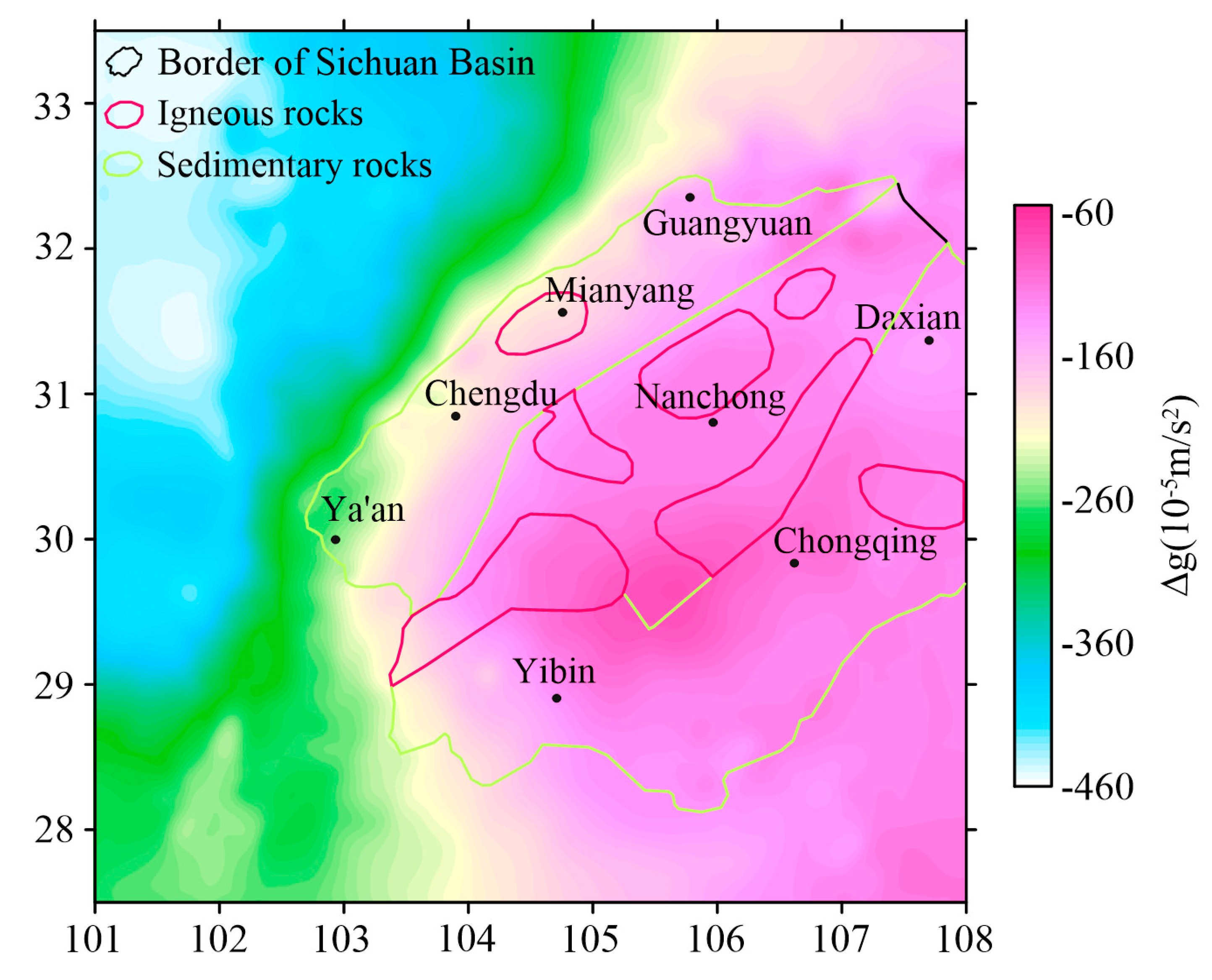
3.1. Bouguer Gravity Anomaly Characteristics

The Bouguer gravity data used in the Sichuan Basin was provided by China Geological Survey. It came from the measured data on the scale of 1:500,000 and the sampling interval was 5 km. It was processed by normal field correction, Bouguer correction and topographic correction in 2000. The Bouguer gravity anomaly in the central and western Sichuan Basin is shown in Figure 2. It can be seen that the Bouguer gravity anomaly in the basin shows a gradual increase from west to east, which corresponds to the observation that the crust in the basin is thick in the west and thin in the east. The Bouguer gravity anomaly value in the study area is between 290 × 10−5 m/s2 and −60 × 10−5 m/s2, the maximum value is located in the western region of Chongqing, and the gravity anomaly value is −60 × 10−5 m/s2. The minimum value is located near the northeast direction of Ya’an, and the gravity anomaly is −255 × 10−5 m/s2. There is a high–value gravity anomaly trap (greater than −80 × 10−5 m/s2) in western Chongqing and a low–value gravity trap (less than −110 × 10−5 m/s2) near Nanchong. In addition, there are several obvious gravity lineaments in Mianyang-Chengdu, Yibin–Chongqing, etc. Combined with previous studies [13], it is believed that these are closely related to the main fault systems inside and around the basin.
The Bouguer gravity value in the western part of the basin is between −215 × 10−5 m/s2 and −145 × 10−5 m/s2. The gravity height in the western region of Chongqing is quite obvious. The Bouguer gravity shows a low and slow gravity anomaly, with scattered positive and negative trap anomalies. There is an obvious gravity anomaly gradient zone in the western margin of the basin, which may be closely related to the fault system around the basin [14]. The anomaly trend changes from northeast to nearly north–south, reflecting the gradual thinning trend of crustal thickness from northwest to southeast. The variation in the Bouguer gravity anomaly value in the central region of the basin is small, which is a gradual change region of gravity anomaly. The gravity anomaly value is between −145 × 10−5 m/s2 and −80 × 10−5 m/s2, and the gravity height in the western region of Chongqing is quite obvious. A high–value gravity trap area appeared near Nanchong. The Bouguer gravity value in this area is about −85 × 10−5 m/s2, which is in the northeast direction. It is speculated that the occurrence of high–value Bouguer gravity is related to the high–density core or old base uplift in this area [15], which is usually formed by multiple tectonic movements. The Bouguer gravity anomaly in the eastern part of the basin is characterized by the development of isolated small trap anomalies in a low and gentle background, which is strongly associated with exposed structures and is spread on the surface [16]. The appearance of the regional gravitational field is an elective fold belt.
Figure 2. Map of the Bouguer gravity anomalies in central and western Sichuan Basin (modified from Zhou [13] and Chen et al. [17]).
Processes 11 01200 g002

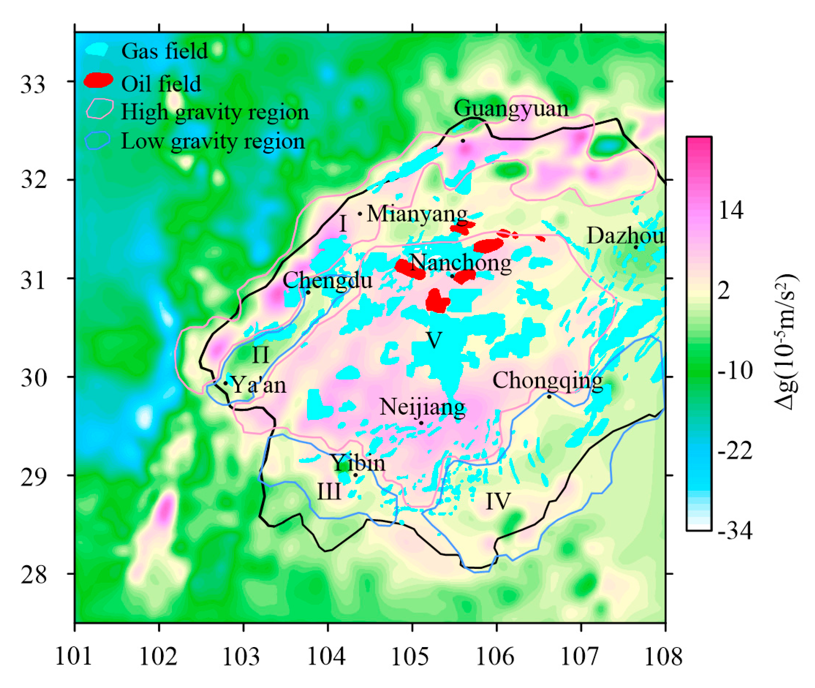
3.2. Residual Gravity Anomaly Characteristics

Regional anomalies and residual anomalies are relative and are generally classified according to the geological target under study. Residual gravity anomalies can increase the local geologic body–induced gravity field effect to suppress regional background, improve the resolution of local anomalies, and separate adjacent residual density bodies.
This paper uses upward continuation to separate the deep and shallow anomaly sources. The gravity anomaly with upward continuation of 7.5 km is selected as the background gravity value of the central and western Sichuan Basin. The original Bouguer gravity anomaly and its difference are taken as the residual gravity anomaly (Figure 3). It can be seen that the local gravity–high and local gravity–low in the central and western Sichuan Basin are arranged alternately. The low–density residual gravity traps in the study area are mainly located in the eastern and southern Sichuan areas, and these traps have certain coherence. There are a large number of high–density residual Bouguer gravity traps in the central and northern parts of the study area. The distribution scale is relatively large and has certain coherence [18].
Based on the analysis of local residual gravity anomalies, geological data and deep seismic reflection data, the local gravity anomalies in the study area are divided into five categories according to the geological causes of gravity anomalies. Respectively, they are: high gravity value in the Longmenshan–Micangshan area, high gravity value in the Neijiang–Nanchong area, the gravity low–value area in Ya ’an, the gravity low–value area in Huayingshan–Qiyueshan and the gravity low–value area in Yibin.
High gravity value in Longmenshan–Micangshan area: Micangshan in the north of the basin and Longmenshan in the west of the basin show a steep increase in basin–mountain relationship with the Sichuan Basin in topography, and the elevation changes dramatically [13]. It is controlled by the formation and evolution of the Qinghai–Tibet Plateau and the basement detachment layer, and the bottom contains a considerable depth of sedimentary rocks [13]. The Longmenshan tectonic belt in the north of the basin is characterized by low contour amplitude and small coverage, but a high Bouguer gravity value. This reflects that the fault of the structural belt develops in the depth, and the width is vast; a vital boundary dividing the Songpan–Ganzi fold belt from the Yangtze platform. The geological and physical characteristics on both sides are completely different. The residual gravity anomaly values in the western part of the basin are generally between 5.0 × 10⁻⁵ m/s2 and 24 × 10−5 m/s2, showing a gradual increase from the northeast to the southwest. The high value is approximately banded, and the Longquanshan fault zone limits the regional boundary. The shallow surface of the high–value gradient zone develops a thick and highly dense Triassic–Permian limestone layer.
High gravity value in Neijiang–Nanchong area: The development of faults and folds in central Sichuan is weak, and the crystalline basement is composed of various gneisses and igneous rocks. The sedimentary cover in this area is developed gently, showing a large northwest–trending monoclinic structure, and the bedrock is composed of deep pre–Sinian metamorphic rock–shallow metamorphic rock. The central Sichuan area is shown as a local high-value Bouguer gravity trap with high contour amplitude and wide coverage. It can be concluded that there may be paleo–uplifts in the center of the Sichuan Basin. The minimum residual gravity anomaly value is 3.0×10⁻⁵ m/s2, and the surface of the area exposes low–density Jurassic strata. It is speculated that these strata may be affected by the development of loose Jurassic clastic layers with a certain thickness in the shallow surface [19].
The gravity low–value area in Ya ’an: The residual gravity anomaly values in this area are between −15 × 10−5 m/s2 and 4.0 × 10⁻⁵ m/s2, and both sides are high–gravity areas with prominent gravity zoning characteristics, which reflects that the Ya ’an area is composed of interconnected parallel imbricate thrust belts with typical thrust nappe [20,21]. This is because the Longmenshan secondary block is pushed by the southeastward movement of the Qinghai–Tibet Plateau, resulting in a significant positive anomaly change of the Ya ’an area. After being blocked by the rigid crustal structure of the Sichuan Basin, the flowing down material continues to flow southeastward, and leads to a certain degree of basement uplift in the Sichuan Basin [21].
The low–value gravity area in Huayingshan–Qiyueshan: The parallel banded valley landform east of the basin’s edge comprises several ridges. The development of the fold structure of the fault is slow, resulting in a vast difference between the surface structure and the deep structure. The deep layer is generally developed by faults and folds generally develop the shallow layer. Generally, the deep part is mainly fault, and the surface layer is folded. However, central and eastern Sichuan are mainly divided by the Huayingshan fault zone, which is particularly obvious in the residual gravity anomaly map, showing the boundary between high and low gravity anomalies. The residual gravity anomaly in eastern Sichuan is between −15 × 10−5 m/s2 and 10 × 10−5 m/s2. There are small low–value traps in the low–value residual gravity area in the region’s south. There are many large–scale fault zones, secondary tensile faults are developed, and the layers are broken, resulting in the distortion of the residual gravity anomaly contour [22].
The low–value gravity area in Yibin: The amplitude of residual gravity anomaly is about −14 × 10−5 m/s2 and 7.0 × 10⁻⁵ m/s2. The residual gravity anomaly in the region has the characteristics of ‘local multi–traps and small change range’, which is mainly caused by two reasons: firstly, the fold deformation is strong, resulting in many closed synclines, and synclines and anticlines accumulating and arranging; secondly, the high–density Triassic–Permian limestone strata in the syncline are thinly developed, and the main feature is that the residual gravity anomaly is strong, while the Cambrian dolomite outcrops on the surface form an anticline, and the buried depth of high–density limestone and Sinian deep high–density strata is also relatively shallow [23,24].

4. Tectonic Unit

Since the formation of the first sedimentary layer at the bottom of the Sichuan Basin (Sinian Doushantuo Formation), in the process of tectonic evolution and development of the basin, the structure and transformation interact and develop in an episodic manner, forming a unique multi–cycle fold structure in the Sichuan Basin. In order to determine the correlation between the tectonic units of the central and western Sichuan Basin, based on the characteristics reflected by the Bouguer gravity anomaly and the residual gravity anomaly, three regional seismic reflection profiles in the NW-SE direction (L1, L2, L3) were selected for structural interpretation (Figure 4).combined with the results of three seismic reflection profiles in the study area, the tectonic units of Sichuan Basin were delimited comprehensively (Figure 4).
L1 was located in the northern part of the basin, the total length is 380 km, and the direction of the seismic profile is from NW to SE. In the eastern part of the basin, there are seven geological structures: Huayingshan structure, Pubaoshan structure, Qilixia structure, Datianchi structure, Huangnitang structure, Dachigan structure, and Fangdoushan structure. The Huacong, Longgang, Shuikouchang, and Shuishen No.1 wells were passed north of the basin. In the west of the basin, through the Hewanchang and Jiulongshan structures (Figure 5a).
L2 was located in the central part of the basin with a total length of about 390 km. From northwest to southeast, it passes through the center of the Sichuan Basin, from northwest to Mianyang and from southeast to Chongqing. The section passes through the Jinhua, Longnvsi, and Nvjijing structures in the middle of the basin. In the eastern part of the basin, the Huayingshan structure, Zhongliangshan structure, Longwangdong structure, Tongluoxia structure, Mingyuexia structure, and Fengshengchang structure are passed through the six geological structures (Figure 5b).
L3 is located in the southern part of the basin, about 400 km long, from northwest to southeast through the western basin Gaojiachang structure, Baimamiao structure, and Xiongpo anticline. In the south of the basin, L3 passed through the Longquanshan structure, Weiyuan structure, Luoguanshan structure, Gufoshan structure, Longdongping structure, and Liziba structure of the six geological structures Ziyang No.5 well and Zishen No.2 well (Figure 5c).
Combined with the results of gravity anomalies and seismic reflection data, the tectonic units of the central and western Sichuan Basin are divided into five blocks, which are the central Sichuan uplift area, the western Sichuan depression area, the eastern Sichuan high and steep area, the southern Sichuan low and steep area and the northern Sichuan low and gentle area, as shown in Figure 6. As can be seen from the figure, it is roughly equivalent to the previous division results, which are reflected in the central region as the uplift area, the western region as the depression area, the northern region as the low–slow area and the southern region as the high–steep area.
The central Sichuan uplift area is located east of the Longquan mountain fault zone and west of the Huayingshan fault. It is the most stable central uplift in it, and has maintained highly position since the Sinian period [25]. There are relatively wide and gentle fold structures in the shallow layer of this area, and the number of fractures is small. The deeper the fracture is, the smaller and weaker it is. Previous research [2] has shown that this area presents the characteristics of high resistance, a high–velocity layer and high–density paleostratum. It corresponds to the high–gravity anomaly value and seismic profile L2 protrusion characteristics in this area. It is in a multi–directional extrusion tectonic environment, and the fold–thrust structure around the basin is strongly deformed.
It is a foreland depression formed in the western Sichuan Basin since the Late Triassic [26,27]. There are three sets of main structures, which are characterized by nearly east–west trending, nearly north-south trending and northeast–trending, with east–west tilt zoning, north–south trending segmentation and north–south vertical stratification [28]. There is an obvious gravity gradient belt in the Bouguer gravity anomaly map, and it is shown as a high gravity value in the residual gravity anomaly map. The buried depth of the basement is more than 8 km [29], the structure is generally in the northeast direction, the fold amplitude is large, the fault is developed, and there is continuous subsidence after the Indosinian movement. The high and steep area of eastern Sichuan is located southeast of the Huayingshan fault zone. The east boundary is the Xuefeng uplift, dominated by metamorphic basement strata. The northern boundary is the northwestward–southeastward trending South Dabashan arc orogenic belt. In this region, the Bouguer gravity anomaly is high, and several isolated small high–value Bouguer gravity anomaly traps are developed, most of which are shown as low gravity values in the residual gravity anomaly map. The basement lithology of shallow strata is non-magnetic or weakly magnetic, and the buried depth of the basement is 6–10 km [30,31,32]. The gravity anomaly zone in this area strikes nearly east–west, and the eastern part of Chongqing shows a negative gravity anomaly, which is generally manifested as an arc–shaped structural belt that protrudes slightly to the northwest, interspersed with a series of intricate anticlines, synclines and faults alternately arranged [33].
The low-steep area of southern Sichuan is located south of the Huayingshan fault. It can be seen from the residual gravity anomaly diagram that there are alternating distribution characteristics of high gravity and low gravity, and the region is generally shown to have a low gravity anomaly, with a basement depth of 3–5 km. It is the highest uplift and shallowest buried area of sedimentary cover in the Sichuan Basin. The tectonic belt is more complex, the crustal tectonic movement is more intense, the fold deformation in the region is severe, and multiple secondary fault zones have developed, which have experienced multi–period complex crustal movement [29,30,31]. In addition, the oil and gas in southern Sichuan are not affected by structural traps, most of which exist in structural styles.
Along the piedmont fault fold belt, the low, gentle area of North Sichuan extends north to the Micangshan orogenic belt and the Dabashan orogenic belt. In this area, the high and low Bouguer gravity are interphase. It can be seen that there is an obvious gravity anomaly zone in the residual gravity anomaly map, which is the high gravity anomaly value, due to different structural stresses, local structural units such as thrust nappe structural belts, back thrust anticline structural belts and low fold belts are formed, and the buried depth of bedrock is more than 8–10 km [29]. The development of local structural folds in this area is not obvious. After the Caledonian movement, faults developed and continued to subside, forming a geological depression.
Compared with the previous division of tectonic units in the Sichuan Basin, there are three differences in the division of tectonic units in this paper, namely, central Sichuan, southern Sichuan, and northern Sichuan. The divided difference between central and southern Sichuan is mainly based on the Huayingshan fault zone and the residual gravity anomaly map. Most residual gravity anomaly maps in the central Sichuan area show positive anomalies, while the divided southern Sichuan area obviously has negative anomalies. This is because the basin’s southern part is affected by multi–stage structures and is compounded with the surrounding structures, reflecting the relatively shallow burial depth of the high–density basement in the surrounding area. The reason for the anomaly is that the Huayingshan fault zone forms thrust compression under the action of the NW–trending principal compressive stress field, which plays a significant role in controlling the sedimentary formation and tectonic deformation in eastern, central, and southern Sichuan [34]. The difference in the division of the low–slow area in northern Sichuan is based on the residual gravity map of the Sichuan Basin, the basement structure of northern Sichuan and the distribution of faults, and the tectonic unit line of the low–slow area in northern Sichuan is slightly moved to the interior of the basin.

5. Oil-Gas Distribution

The Sichuan Basin is a more typical superimposed western China basin and the largest petroliferous basin. It has formed many oil and gas fields (Figure 7). The predecessors have also conducted a lot of research on the distribution of oil and gas fields in the Sichuan Basin and obtained a series of important understandings.
Current distribution characteristics of big and middle–sized oil and gas fields in the Sichuan Basin reflect the spatial distribution characteristics of residual oil and gas fields during the uplift and denudation of Mesozoic and Cenozoic basins and the adjustment and transformation. At present, Micangshan Mountain and Daba Mountain in the north of the basin have a total of 21 gas fields (including 10 large gas fields and 11 medium–sized gas fields). The number of large oil and gas fields in the central basin is small [24].
Types of large and medium gas fields are mainly associated with paleo uplift and tilted zone of paleo uplift [35]. It can be seen that the paleo uplift is very important in the oil and gas cumulation process. Three paleo–uplifts were formed during the evolutionary development of the Upper Yangtze Craton in the Sichuan Basin: Leshan–Longnvsi paleo–uplift, Luzhou paleo–uplift and Kaijiang paleo–uplift. Each paleo–uplift evolved and developed in different periods, distributed in different regions of the Sichuan Basin, and had different evolution stages [36].
Leshan–Longnvsi ancient paleo uplift developed in the western margin of the basin, and continued until the Permian sedimentary evolution [32]. It is speculated that the formation is related to the strong collision and extrusion of the Yangtze plate and the North China plate along the Mianlue suture zone. The Longmen mountain fault zone is the boundary of positive and negative Bouguer gravity anomalies between the Sichuan Basin and Songpan–Ganzi block. There is an obvious Bouguer gravity anomaly zone in the western margin of the Leshan–Longnvsi ancient paleo uplift, and the residual gravity anomalies are interdistributed with high gravity and low gravity, of which the high gravity value area occupies a large part. The abnormal values on both sides decreased sharply, and the abnormal values decreased from 16 × 10−5 m/s2 to −8 × 10⁻⁵ m/s2, which was consistent with the topographic characteristics of the western margin of the Sichuan Basin. Multiple gas fields found in the western Sichuan area are mainly located in the ancient uplift zone, which is mostly the residual high gravity zone and the transition zone between high gravity and low gravity zones, in which the detachment layer is not developed, the ground faults are few, the sedimentary cover is thin, and the fold is gently developed [37].
The formation of the Luzhou paleo–uplift located at the southern end of the Huaying mountain structural belt in southern Sichuan has a certain influence on the tectonic framework of southern Sichuan [38]. The Bouguer gravity anomaly in the Luzhou paleo–uplift region has a high value anomaly trap, the gravity value in the high value anomaly closure area is about −70 × 10−5 m/s2, and the residual gravity anomaly is distributed between high gravity and low gravity. The Indosinian orogenic movement of surrounding blocks controls the Luzhou paleo–uplift’s formation, evolution and development. It is a front uplift zone formed during the migration from east to west and the Xuefengshan orogenic belt extrusion on the Yangtze block’s southeastern margin [39]. It was developed in the Indo–Chinese epoch, and its nucleus is located in Luzhou, extending in a north–easterly direction. The residual gravity anomaly in the southern Sichuan area is gradually increased to the north–east. The Bouguer gravity anomaly in the southeastern margin of the Sichuan Basin is characterized by a north east–south west zonal distribution. It overlaps with the low–value area of the annular negative anomaly with the small scattered distribution. The low–value area may reflect the influence of the evolution of the nearly north–south structural belt in southern Sichuan. The residual gravity anomaly values in the study area are generally between −13 × 10−5 m/s2 and 12 × 10−5 m/s2, and continue to extend to the southeast. The residual gravity anomaly increases to 12 × 10−5 m/s2. It continues to increase to the southeast, reflecting a significant change in the crustal structure or the degree of crustal tectonic uplift and deformation [40]. The oil and gas fields in this area are mainly distributed in the Luzhou palaeo uplift and are located in the area of high residual gravity anomaly.
The Kaijiang paleo–uplift and the Luzhou paleo–uplift located in northeastern Sichuan are located in the same uplift belt, with similar evolution characteristics. They are NE–trending erosional paleo–uplifts formed in the Indosinian movement at the end of the Middle Triassic [29]. Bouguer gravity in this region presents a band of high–value anomalies with a small variation range. The residual gravity anomalies are intermingled with high gravity and low gravity, with a maximum value of 2.0 × 10⁻⁵ m/s2 and a minimum value of −8.0 × 10⁻⁵ m/s2. Some small trap anomalies are growing from the Kaijiang paleo–uplift area. The analysis is related to this area’s exposure and distribution of structural arc belts and deep strata [9]. The explored oil and gas fields in this area are mainly distributed in the transition area between the residual high gravity anomaly area and the low gravity area.
The Bouguer gravity value in the central and western Sichuan Basin shows a stable regional high–value anomaly. The gravity anomaly changes gently, and the amplitude is low, caused by basement uplift of the whole basin. In the basin, the high and low residual gravity anomalies are distributed in alternate phases, corresponding to the distribution of oil and gas fields. There are obvious gravity gradient zones in the western and northern margins of the basin, and the Longmenshan fault zone and Micangshan uplift are developed. The oil and gas fields in these two areas are more widely distributed. In the eastern region of the basin, there is contour distortion in the residual gravity anomaly, which is due to the development of more fault zones, more secondary tension faults, interlayer fracture due to extrusion of the Huayingshan fault zone, good conditions for oil and gas generation and preservation, and the distribution of oil and gas fields in this region. In the south, there are many low–gravity anomaly traps that do not correspond to the distribution of oil and gas fields. This is due to the strong fold deformation in this area. The basin is generally characterized by high–density rigid block, stable internal structure, developed source rock and high gas formation rate [32]. Due to the entire basement uplift and the strong deformation of metamorphic rocks and magmatic rocks, the Sichuan Basin has an obvious double–layer structure; that is, the underlying basement tectonic layer and the overlying tectonic layer composed of sedimentary rocks, and the basement structure and caprock structure and their configuration relationship determine the oil and gas distribution to a certain extent [2]. Since the Late Paleozoic, the Sichuan Basin’s sedimentary environment has always been relatively stable, all of which are Cenozoic sediments, so the residual gravity anomalies show low–value anomalies. Because sediments provide basic conditions for the development of source rocks, there are many oil and gas fields in the basin, mainly located in the highly steep areas of eastern Sichuan, western Sichuan depression and central Sichuan uplift.
In summary, it was found that the main distribution of large and medium–sized oil and gas fields discovered in the Sichuan Basin nowadays is controlled and influenced by basin basement structure, sedimentary cover and peripheral faults. Comparing the distribution of oil and gas fields with the distribution of residual gravity anomalies in the basin and paleo–uplifts distribution map (Figure 7), most of the oil and gas fields in the central and western Sichuan Basin correspond to high gravity areas, but there is a close correlation between low gravity and oil and gas fields near Dazhou, which is caused by the existence of high–quality reef beach reservoirs, deep and large faults, and reservoir cracking of large-scale paleo–uplift.

6. Conclusions

  • The Bouguer gravity anomaly values in Sichuan Basin are all negative, showing a trend of gradually increasing from west to east with a small variation, and the gravity gradient zone bounds the basin margin. The residual gravity field of the basin shows obvious gravity high values in general in the interior, and there is a local characteristic that local gravity is high and local gravity low in an alternating arrangement.
  • It can be seen from the large oil fields proven in the study area that there is a certain correlation between the distribution of oil and gas fields and the transition zone between local high gravity values, high gravity values, and low gravity values. This is due to the development of fault structures in the basin, which provides a good channel for the migration of oil and gas reservoirs. The evolution of the paleo–uplift area is stable, and the paleo–oil reservoir is cracked in–situ and accumulated nearby with high efficiency.

Author Contributions

Conceptualization, Q.C. and X.H.; methodology, Q.C.; software, Q.C.; validation, Q.C., X.H. and H.C.; formal analysis, H.C.; investigation, G.L.; resources, Q.C.; data curation, G.L.; writing—original draft preparation, Q.C. and X.H.; writing—review and editing, Q.C. and X.H.; visualization, J.Z.; supervision, H.C.; project administration, Q.C.; funding acquisition, Q.C. All authors have read and agreed to the published version of the manuscript.

Funding

This study is supported by the National Natural Science Foundation of China under Grant No. 41702210, “Mechanical strength and lithosphere deformation characteristics in the northern half of the north–south tectonic zone and surrounding areas”; Chongqing Natural Science Foundation of China under Grant No. cstc2021jcyj–msxmX1070, “Analysis of the origin of the Wenchuan earthquake and the characteristics of the Longmenshan tectonic zone’s lithospheric deformation”.

Data Availability Statement

The data used in this study is confidential, it cannot be shared.

Conflicts of Interest

The authors declare no conflict of interest.

References

  1. Wang, L.Q.; Fan, C.H.; Fan, Z.H.; Jiang, B. Presumption of the tectonic evolution and regional sedimentation of the Sichuan Basin based on seismic exploration technology. Nat. Gas Ind. 2016, 36, 18–26. [Google Scholar]
  2. Li, H.K. Study on the Geological Structure and Superimposed Characteristics of Sichuan Basin. Ph.D. Thesis, Chengdu University of Technology, Chengdu, China, 2020. [Google Scholar]
  3. Deng, B. Meso-Cenozoic Architecture of Basin-Mountain System in the Sichuan Basin and Its Gas Distribution. Ph.D. Thesis, Chengdu University of Technology, Chengdu, China, 2013. [Google Scholar]
  4. Wang, X.J.; Yang, Z.R.; Han, B. Superposed evolution of Sichuan Basin and its petrolrum accumulation. Earth Sci. Front. 2015, 22, 161–173. [Google Scholar]
  5. Liu, S.; Deng, B.; Li, Z.; Jansa, L.; Liu, S.; Wang, G.; Sun, W. Geological Evolution of the Longmenshan Intracontinental Composite Orogen and the Eastern Margin of the Tibetan Plateau. J. Earth Sci. 2013, 24, 874–890. [Google Scholar] [CrossRef]
  6. Lu, X.F. Main Structural Interfaces of Sichuan Basin Obtained from Inversions of Gravity Anomalies through Modified Very Fast Simulated Annealing Method. Master’s Thesis, Northwestern University, Evanston, IL, USA, 2011. [Google Scholar]
  7. Gong, D.X. The Triassic Salt-Forming Environment, Potash-Forming Conditions and Genetic Mechanism in Sichuan Basin. Ph.D. Thesis, Chengdu University of Technology, Chengdu, China, 2016. [Google Scholar]
  8. Zhang, G.; Guo, A.; Wang, Y.; Li, S.; Dong, Y.; Liu, S.; He, D.; Cheng, S.; Lu, R.; Yao, A. Tectonics of South China continent and its implications. Sci. China Earth Sci. 2013, 56, 1804–1828. [Google Scholar] [CrossRef]
  9. Gao, M. Research on Deep Geological Structure of Sichuan Basin Based on Gravity and Magnetic Field Data Analysis. Master’s Thesis, Chengdu University of Technology, Chengdu, China, 2019. [Google Scholar]
  10. Chen, Z.; Wang, L.; Yang, G.; Zhang, B.; Ying, D.; Yuan, B.; Pei, S.; Li, W. Geological structures and potential petroleum exploration areas in the southwestern Sichuan fold-thrust belt, SW China. Pet. Explor. Dev. 2020, 47, 699–713. [Google Scholar] [CrossRef]
  11. Shao, Z.Y. A Comparison Study of Geological Elements Controlling Hydrocarbon Accumulation in Deep and Shale Plays in Sichuan and Permian Basins. Master’s Thesis, China University of Petroleum, Beijing, China, 2019. [Google Scholar]
  12. Zhihong, Z.; Denghua, L.; Senshu, B.; Jun, J.; Xin, Z.; Zhuoya, L.; Xuan, G. Resource potentials of natural gas in Sichuan Basin. China Pet. Explor. 2020, 22, 12–20. [Google Scholar]
  13. Zhou, W.S. Gravity and Magnetic Anomalies in the Sichuan Basin, China: Implication for Deep Structures. Master’s Thesis, Nanjing University, Nanjing, China, 2016. [Google Scholar]
  14. Su, G.P. Study on Structural Characteristics and Tectonic Evolution in the Northern Slope of Central Sichuan Paleo-Uplift and Their Influences on Hydrocarbon Accumulation. Ph.D. Thesis, Chengdu University of Technology, Chengdu, China, 2021. [Google Scholar]
  15. Fang, C.M. Study on The Pattern of Thrust Structure and Oil & Gas Distribution in the Typical Piedmont Thrust Belt in the Central and Western China. Ph.D. Thesis, China University of Geosciences, Wuhan, China, 2018. [Google Scholar]
  16. Xu, G. Research on Transformation of Tectonic Framwork in the Northeast Sichuan Basin on Triassic and its Control of Multi Minerals Deposition. Ph.D. Thesis, China University of Geosciences, Beijing, China, 2019. [Google Scholar]
  17. Chen, Q.; Dong, Y.; Tan, X.; Wang, J.; Huang, X.; Chen, H. Applying the Tilt-depth and Tilt-Euler techniques of gravity data to decipher the basement depth in Sichuan Basin, China. Acta Geophys. 2021, 69, 2173–2186. [Google Scholar] [CrossRef]
  18. Xiao, L.; Jianliang, X.; Ying, W.; Xinyan, F.; Lei, Z.; Yijia, W.; Bin, D. The shale gas enrichment factors of Longmaxi Formation under gradient basin-mountain boundary in South Sichuan Basin: Tectono-depositional differentiation and discrepant evolution. Chin. J. Geol. 2021, 56, 60–81. [Google Scholar]
  19. Ye, Z. Study on developing Features and Petroliefrous Charaeters of Basins in Middle and Lower Yangtze Area. Ph.D. Thesis, Southwest Petroleum University, Chengdu, China, 2006. [Google Scholar]
  20. Zhang, X.M.; Liu, X.L. Application of regional gravity survey in dividing fault structures in Ya’an area. J. Henan Sci. Technol. 2013, 13, 193–194. [Google Scholar]
  21. Zhao, L.L. Research on the Regional Time-Varying Gravity Field and Bouguer Gravity Anomaly by Using GRACE Gravity Satellite. Master’s Thesis, Chang’an University, Xi’an, China, 2017. [Google Scholar]
  22. Yang, G.C. Evolution of Sequence-Filling and Tectono-Lithofacies Paleo-Geography from Late Jurassic through Neogene in Sichuan Basin. Ph.D. Thesis, China University of Geosciences, Beijing, China, 2010. [Google Scholar]
  23. Zhao, R. Research on the System of Regional Karst Water in the Topographic Gradient Zone of the South Edge of Sichuan Basin. Ph.D. Thesis, Chengdu University of Technology, Chengdu, China, 2016. [Google Scholar]
  24. Hu, Y.; Chen, L.; Zhou, H.; Tan, X.C.; Li, X.S.; Wang, W.J. Lamina characteristics of marine shale and its influence on shale reservoir development: A case study of Longmaxi Formation, Changning area, South Sichuan Basin. Fault-Block Oil Gas Field 2021, 28, 145–150. [Google Scholar]
  25. Jia, D.; Wei, G.Q.; Yang, W.; Shen, L.; Zi, J.P.; Hu, J. Fundamental tectonic characteristics and hydrocarbon relationships at the eastern border of the Qinghai-Tibet Plateau’s Sichuan Basin. China Acad. J. Electron. Publ. House 2015, 45–46. [Google Scholar]
  26. Li, W.Y. Structural Characteristics and Evolution of the Middle and North Part of Western Sichuan Basin. Ph.D. Thesis, China University of Petroleum, Beijing, China, 2020. [Google Scholar]
  27. Li, Z.W.; Liu, S.G.; Lin, J.; Tang, C.; Deng, B.; Sun, W. Structural configuration and its genetic mechanism of the West Sichuan depression in China. J. Chengdu Univ. Technol. Sci. Technol. Ed. 2009, 36, 645–653. [Google Scholar]
  28. Wu, H. Meso-Cenozoic Tectonic Uplift Process of the Eastern Sichuan Basin. Ph.D. Thesis, China University of Petroleum, Beijing, China, 2019. [Google Scholar]
  29. Liu, W. Study on Pore Pressure of the Sinian-Paleozoic in the Central and Western Sichuan Basin. Ph.D. Thesis, China University of Petroleum, Beijing, China, 2018. [Google Scholar]
  30. Yutao, Z.O.U.; Jinbao, D.U.A.N.; Yanjun, Z.H.A.O.; Xin, Z.; Rangbin, L. Tectonic characteristics and evolution of the high and steep fault folding belt in East Sichuan. Acta Geol. Sin. 2015, 89, 2046–2052. [Google Scholar]
  31. Liu, S.G.; Sun, W.; Song, J.M.; Deng, B.; Zhong, Y.; Luo, C.; Ran, B.; Tian, H.Y.; Li, Z.B.; Peng, H.L. Tectonics-controlled distribution of marine petroleum accumlations in the Sichuan Basin, China. Earth Sci. Front. 2015, 22, 146–160. [Google Scholar]
  32. Ying, F.E.N.G.; Meizhou, D.E.N.G.; Yajing, L.I. Control effect of faults on hydrocarbon accumulation: A case study of gas reservoir of the second member of Xujiahe Formation, Dongpo area, western Sichuan Basin. Fault-Block Oil Gas Field 2021, 28, 586–591. [Google Scholar]
  33. Ye, H.U.; Xiaoyu, Y.U.A.N.; Yanqing, W.A.N.G.; Guangxiang, L.I.U.; Xiaobo, S.O.N.G. Developmental characteristics and oil control of Indosinian paleo-uplifts in West Sichuan Depression, Sichuan Basin. Pet. Geol. Exp. 2018, 40, 650–654. [Google Scholar]
  34. Quan, Z.; Bo, Q.; Jian, Z.; Yang, H.; Dawei, N. Analysis on seismicity characteristics of Huayingshan fault zone. Prog. Earthq. 2021, 51, 461–466. [Google Scholar]
  35. Dai, H.R. Processing and Interpretation of Gravity and Magnetic Anomalies in Eastern Sichuan and Tibet and Research on Crustal Structure. Ph.D. Thesis, China University of Geosciences, Beijing, China, 2021. [Google Scholar]
  36. Xu, C.; Shen, P.; Yang, Y.; Zhao, L.; Luo, B.; Wen, L.; Chen, K.; Ran, Q.; Zhong, Y.; Peng, H. New understandings and potential of Sinian-Lower Paleozoic natural gas exploration in the central Sichuan paleo-uplift of the Sichuan Basin. Nat. Gas Ind. 2021, 8, 105–113. [Google Scholar] [CrossRef]
  37. Yang, Y.; Wang, S.Q.; Pan, Y.; Gao, G.M. Distribution characteristics of gravity anomalies in the Sichuan-Yunnan region. J. Yunnan Univ. Nat. Sci. Ed. 2021, 43, 921–928. [Google Scholar]
  38. Gu, Z.; Yin, J.; Jiang, H.; Li, Q.; Zhai, X.; Huang, P.; Peng, P.; Yang, F.; Zhang, H. Discovery of Xuanhan-Kaijiang Paleouplift and its significance in the Sichuan Basin, SW China. Pet. Explor. Dev. 2016, 43, 976–987. [Google Scholar] [CrossRef]
  39. Li, X.Q.; Wang, Z.C.; Zhang, X.W.; Liu, Q.; Yan, J.M. Characteristics of Paleo-Uplifts in Sichuan Basin and their control action on natural gases. Oil Gas Geol. 2001, 22, 347–351. [Google Scholar]
  40. Huang, H.Y. Formation and Evolution of Paleo-Uplift in Southeastern Sichuan Basin and Its Control on Hydrocarbon Accumulation. Ph.D. Thesis, China University of Geosciences, Beijing, China, 2018. [Google Scholar]
Figure 3. Map of the residual gravity anomaly in central and western Sichuan Basin. (Ι: high gravity value in Longmenshan–Micangshan area; ΙΙ: the low–value gravity area in Ya ’an; ΙΙΙ: the low–value gravity area in Yibin; IV: the low–value gravity area in Huayingshan–Qiyueshan; V: high–value gravity in Neijiang–Nanchong area).
Processes 11 01200 g003
Figure 4. Large seismic profile location map of Sichuan Basin (modified from Li [2]).
Processes 11 01200 g004
Figure 5. The deep seismic reflection profiles of Sichuan Basin (modified from Li [2]). (a) L1; (b) L2; (c) L3.
Processes 11 01200 g005
Figure 6. Delineation of tectonic elements of the central and western Sichuan Basin.
Processes 11 01200 g006
Figure 7. Residual anomaly and distribution features of the research area’s major oil and gas fields. (Ι: Leshan–Longnvsi paleo–uplift; ΙΙ: Luzhou paleo–uplift; ΙΙΙ: Kaijiang paleo–uplift).
Processes 11 01200 g007
Disclaimer/Publisher’s Note: The statements, opinions and data contained in all publications are solely those of the individual author(s) and contributor(s) and not of MDPI and/or the editor(s). MDPI and/or the editor(s) disclaim responsibility for any injury to people or property resulting from any ideas, methods, instructions or products referred to in the content.

