Article

Physical Environment Study of Traditional Village Patterns in Jinxi County, Jiangxi Province Based on CFD Simulation

School of Architecture and Design, Nanchang University, No. 999 Xuefu Avenue, Nanchang 330031, China
*
Author to whom correspondence should be addressed.
Processes 2022, 10(11), 2453; https://doi.org/10.3390/pr10112453
Submission received: 27 September 2022 / Revised: 12 November 2022 / Accepted: 16 November 2022 / Published: 19 November 2022
(This article belongs to the Special Issue Innovative Technology for Low Carbon Development)

Abstract

:
As a theory in ancient China, Feng Shui is used in terrain exploring to find ideal living environments. In this study, 62 traditional villages documented on China’s and Jiangxi’s protection lists in Jinxi County, Jiangxi Province were divided into four categories according to their landscape patterns and were simulated by CFD (computational fluid dynamics) with PHOENICS and quantitatively analyzed based on their wind and thermal environments. The results showed that hills greatly improve the wind environment of villages when they are in the windward direction. Concerning thermal environments, water and vegetation effectively reduced the summer temperatures in villages, while hills kept villages warm in winter. This paper verified the positive effect of elements such as mountains, water and forests on the improvement of wind and thermal environments of villages and the rationality of the site election principle of Bei Shan Mian Shui, also known as back mountain facing water, which is upheld by Feng Shui. This paper explored the philosophy of traditional village location selection, demonstrating the ecological wisdom of ancient Chinese people in creating a good living environment, and provides a new direction for current sustainable development planning.

1. Introduction

With the advent of the industrial revolution and continuously improved science and technologies, people’s living standards have been significantly enhanced, which, however, is followed by challenges such as the global energy crisis and climate warming, and the energy shortages and environmental pollution is attracting more attentions from the public [1,2]. As a result, more importance has been attached to green building and sustainable development in recent years. Learning culture and technology from ancient legacies is one way to achieve sustainable development in urban and rural areas [3]. Feng Shui, as an environmental evaluation system concluded and handed down by ancient Chinese people through their accumulated life experiences, serves as a guidance for people to analyze the natural environment, geographical location, etc. In the early stages of settlement construction, ancient people looked for a suitable living environment to ensure their quality of life. The elements of the ecological environment that they concerned included the location, direction, and so on are closely related to Feng Shui, which represented their ecological wisdom in site selection and village planning [4,5].

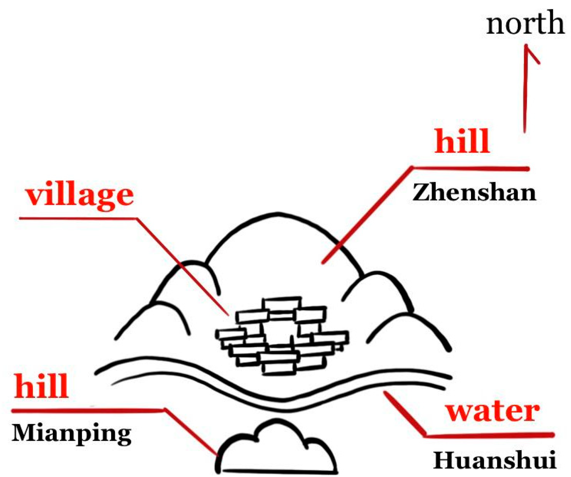
1.1. Traditional Village Site Selection Model Based on Feng Shui Theory

Feng Shui has had a profound and pervasive influence on the construction of traditional villages in Jiangxi Province. The Feng Shui theory in Jiangxi asked people to tailor landscape patterns, and focus on different elements in hills, mountains and plain areas [6]. In a plain where the topography does not vary significantly, the climate elements such as light and monsoon are an important factor in site selection.
By analyzing the concepts of location selection influenced by both Feng Shui and Jiangxi culture as well as engaging in combined field research and literature reading, we found that in Jiangxi traditional villages, an ideal site selection pattern—Bei Shan Mian Shui, which is achieved through the strategies of Zhen Shan, Huan Shui and Mian Ping (Figure 1).
Firstly, Zhen Shan means that a settlement is built with hills at the back to protect it from the cold north wind, while it faces the sun to receive good sunshine. Secondly, Huan Shui, as a location strategy, is designed to meet the villagers’ daily needs for water usage and farmland irrigation, and to improve the climate conditions within the settlement. Thirdly, Mian Ping means there are hills at both the front and north of the village, and this enclosure can moderate the wind speed and make the whole wind environment more stable [7].
In this pattern, a village has a relatively independent and enclosed space by hills, while still being connected to the outside world by water. Hills can keep a village from strong mountain winds all year round, and cold and wet air currents in winter; as well as water can cool the winds as they pass over in summer. For these advantages, villagers’ psychological need for a secure and stable residential environment is met.
Jinxi County lies on the border of the Gan-Fu plain and a hilly area, with hills as the main landscape pattern, and traditional villages mostly located in the plain [8,9]. Due to historical conditions and geographical environment, most traditional villages were unable to naturally achieve the ideal location in the early stages of site selection. Bearing in mind the pattern of Bei Shan Mian Shui, the ancient people actively improved their living environments to pursue the ideal location.
Jinxi is a county with well-preserved historical features and heritage buildings, as well as distinctive local characteristics. According to the five lists of traditional Chinese villages, published by the Chinese Traditional villages Preservation and Development Study Center on September 2022, 42 national traditional villages in Jinxi County, Jiangxi Province have been documented, accounting for 12.24% of the traditional villages in Jiangxi Province, and 43.75% in Fuzhou, Jiangxi Province [10]. Moreover, 31 villages in Jinxi County were selected from the two lists of traditional villages published by Jiangxi government. Jinxi County owns the largest number of traditional villages in Jiangxi Province, which is typical and representative. Therefore, the historic settlements in Jinxi County were chosen for this case study.

1.2. Application of CFD in the Built Environment

Computational fluid dynamics (CFD) is a branch of fluid mechanics dedicated to solving and analyzing problems that involve fluid flows through numerical methods and algorithms. Founded in 1933 by Thom. A, a British scholar, CFD has gradually become a discipline studied and understood by numerous scholars, scientists and engineers. The past 50 years has witnessed the wide use of CFD by a large number of researches on mountain airflow [12,13]. Today, CFD has become a vital instrument for wind field assessment and has been applied extensively to assist architectural design in the US, the UK, Japan and other countries. It can provide designers with parameters and assist them with the layout of urban residential areas in a science-based and sustainable manner, ably suited to the environment [14]. An important focus of CFD-related researches is the pedestrian level wind, which is also one of the physical environmental factors that affect cities and the overall well-being of their residents [15]. It refers to the wind speed at 1.5–2 m above the ground around buildings, which influences pedestrians’ comfort. The configuration of a building, such as its height, width, arrangement and density, has been shown to have a significant impact on the surface wind speed [16,17]. The wind environment is the wind field formed by natural winds under the influence of terrain conditions, architectural layout, greenery and water [18]. The architectural wind environment is closely related to society and people’s lives and can directly affect how people feel and act. Therefore, the comfort level of the wind environment is regarded as a key factor in judging whether the overall ecological environment of a building complex is livable. However, the assessment of pedestrian wind environment, at present, is still in development, and the Beaufort scale is a common index in wind environment evaluation [19,20].
Wind speed not only causes a disparity in pedestrians’ sense of wind power but also impacts the ambient temperatures, thus affecting the thermal environment of a village. The wind environment and the thermal environment are strongly linked to the creation of a microclimate in the village [21].
After reading published literatures, it was found that there are few CFD simulations studies on historic buildings and historical communities. Yao, X.B. et al. used wind speed, wind direction and turbulence intensity as evaluation indicators and a village with a complex architectural layout in southern Shaanxi as the research object, assessed the ventilation performance of the village with the help of three steady-state simulation solvers [22]. Tang, L. et al. by simulating the wind environment of Shanggantang village in central and western China with two-dimensional and three-dimensional terrain models concluded a correlation between the selection of a settlement and its layout and the wind environment of a village [23,24]. Zhao, J.J. et al. conducted a CFD simulation on the wind environment of Shangfeng village in Hubei Province from the perspectives of a whole village and a single building. In terms of settlements, they carried out a quantitative analysis of the wind environment of villages with winds from different directions in winter and summer and discovered the influence of geometric characteristics of roadways on the local wind environment of settlements [25]. Chu, Y.C. et al. taking Huazhai village in Taiwan as a case study, simulated the local wind environment by CFD, compared the restored model of the village buildings in the past with their status quo and proved that early architectural planning gave priority to site selection [26]. Wang, Y.S. et al. verified the regulation effect of different types of village entrance space forms on the wind environment through measured analysis of the wind environment at the village entrance space of traditional villages in Jinxi County, eastern Jiangxi Province combining CFD simulations [27].
Tang, L. et al. conducted a thermal environmental analysis based on Jinjiangli village in southern China. They concluded by evaluating the interaction among the layout, landscape design and surrounding environment that the village layout and the presence of water and vegetation could notably lower rural temperatures and play an important role in improving the microclimate in historical residential [28]. Toparlar, Y. et al. used CFD simulations to predict the urban temperature in Bergpolder Zuid, Rotterdam. They reported that the CFD simulation results had a relatively small error from the actual results and had the potential to forecast urban microclimate accurately [29].
Gao, Y.F. et al. used CFD to simulate and analyze the ecological and physical environment of villages with an ideal Feng Shui pattern with the conclusion that the villages whose site was chosen under an ideal Feng Shui pattern have favorable environmental qualities [30]. Lin, Q. et al. on the research of landscape patterns of the valley-type Shuiyu village, carried out a basic investigation and numerical simulation analysis on the village’s microclimate environment so as to study the coupling correlation and interaction mechanism between the microclimate elements, including wind, humidity, heat, and village landscape pattern [31].
To sum up, there have been notable research achievements in using CFD to simulate historical settlements. However, most of them have mainly focused on villages with ideal locations under the guidance of the typical site selection principle of Bei Shan Mian Shui. While few have engaged in simulations of villages that failed to meet the criterion of ideal site selection but have been artificially improved in terms of landscape conditions. Although the majority of village sites selected are underpinned by Feng Shui, due to historical and geographical restrictions, some villages have to resort to excavating ponds or planting Feng Shui forests to make up for the absence of Feng Shui. In general, these improvement measures are taken out of intuition, which cannot explain the specific physical mechanism of Feng Shui on the site selection of traditional villages.
Hence, starting from 62 traditional villages in Jinxi County, this work utilized CFD simulation technology to analyze whether settlements with different landscape patterns, selected according to Feng Shui theory, enjoy a fine living environment and to delve into the effects of hills, water and other factors that improve the physical environment of villages. In addition, this study aimed to examinate the traditional construction culture for exploring planning strategies that adapt to local climates and to verify the ecological wisdom of the ancient Chinese in sustainable living environments for providing references for current settlement planning.

2. Case Study: CFD Simulation of a Traditional Village in Jinxi
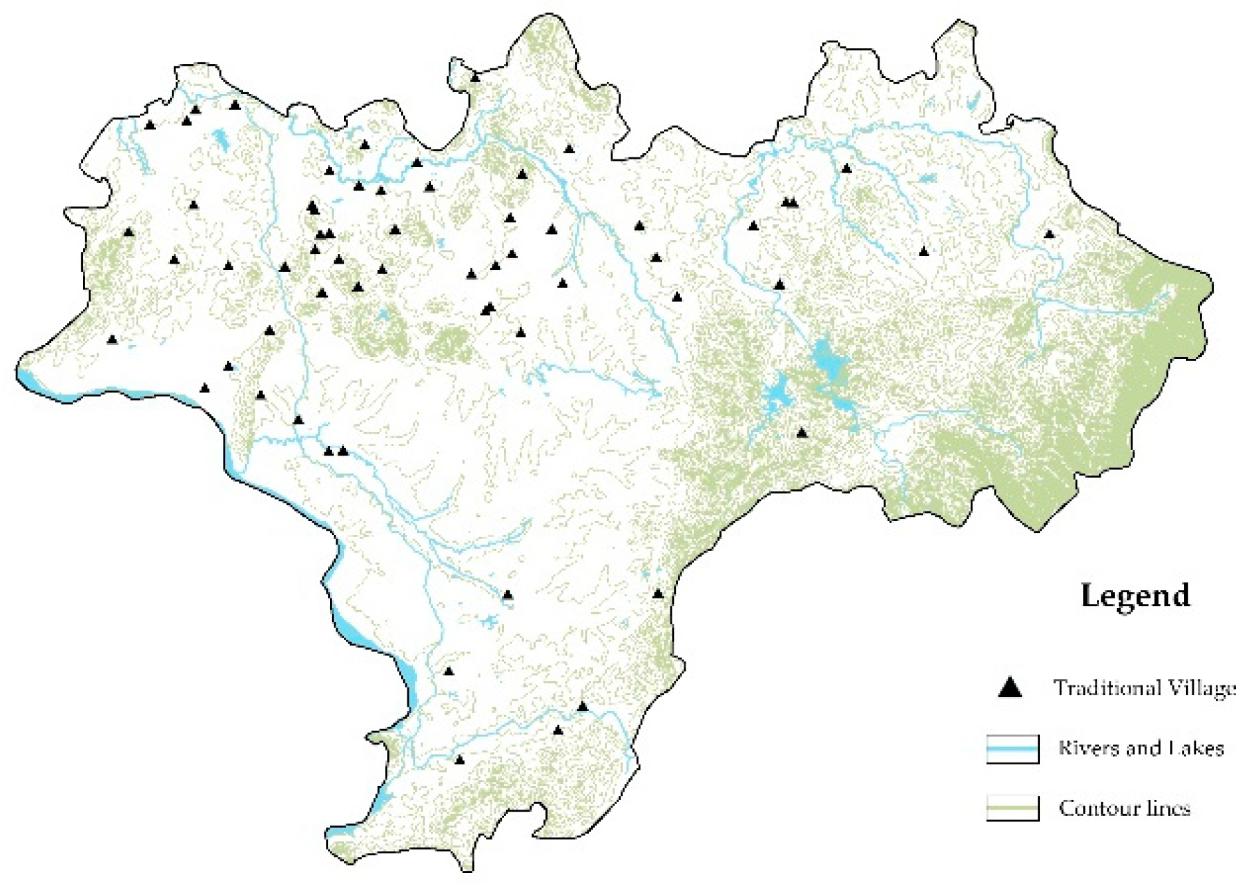
2.1. Study Subjects

Jinxi County, lying at longitude 116°27′–117°103′ E and latitude 27°41′–28°06′ N, located in the east of Jiangxi Province and the middle reaches of the Fuhe River. Jinxi is located in the subtropical zone with humid weather. It is hot in the summer and cold in the winter with an average annual temperature of 17.7 °C and an annual precipitation of 1856 mm. According to statistics from the Jiangxi Meteorological Service, during summer the dominant wind in Jinxi is south and southeasterly with an average speed of 2.8 m/s, and during winter it is north and northeastly with an average speed of 1.9 m/s. Jinxi’s temperature peaks in July with an average temperature of 30.1 °C with a monthly average wind speed of 2.0 m/s and reaches the lowest point in January with an average temperature of 6.8 °C with a monthly average wind speed of 1.9 m/s.
There are 42 national traditional villages and 31 provincial traditional villages in Jinxi, but many of them overlap with each other. Therefore, this paper studied a total of 62 traditional villages after screening out the repetition. To further analyze all these villages, reasonable classification is required. Although there is no unified standard of traditional villages classification in China yet, research abounds in this field. Overall, researchers have divided historic and cultural villages into seven categories by functional types, six categories by their layout and characteristics, three categories by their geographical location and topography, and six categories by their landscape pattern [32,33]. These classification criteria are widely recognized and referenced by academics and have been diversified to meet different research needs.
This paper utilized the geographic information system (GIS) to analyze the villages (Figure 2), collect their geographical information, and their landscape patterns.
With reference to the existing indicators for village classification, this paper gathered information, including their gradient and altitude, from a 500 m radius area with a village as the geometrical center under the help of remote sensing images from Google Maps and GIS. With “hills” and “water” as the key, these villages were divided into four categories by their landscape patterns and geographical location [33]. Their layout characteristics are summarized as follows (Table 1).
Having analyzed the remote sensing image from Google Maps and the characteristics of these villages, four typical villages were selected out of every category as the research object for digital model analyses (Table 2).

2.2. Physical Models and Problem Statements

The article employed AUTOCAD and RHINO to create a three-dimensional physical model based on the topography. Due to the wide space of each village and its surrounding areas, as well as the limited computer capacity, we adopted a simplified model of each village with its geographical features maintained after several alterations, which was more appropriate and practical in modeling (Table 2). The geographical features of the four villages were modeled with a radius of 500 m with each village as the geometrical center. The height of the computational domain was three times that of the model, and in the direction of the inlet, outlet and side walls of the computational domain, the distance between the model and the wall was 2.3 times the length and width of the model separately. Therefore, both the net length and width of the domain were over five times that of the model.
This study was based on PHOENICS, and its built-in PARSOL function was used for structured grid division of the computational domain. To improve the computational accuracy, the places and spaces of the four villages in the domain were further divided into smaller units in the grid. In order to verify the independence of the grid, the computational domain was split up into 1 million, 1.5 million and 2 million units and experiments were conducted accordingly. We examined and compared the statistical analysis of the relative wind speed of the five measurement points in the three different experiments (Figure 3). Through comparison, it was found that when the unit number of the grid was increased for the first time (from 1 million to 1.5 million), the relative wind speed of some measurement points changed remarkably. However, when further increasing the unit number (from 1.5 million to 2 million), the errors rate of the relative wind speed at each measurement point was less than 1%, which proved the grid with 1.5 million units could ensure computational accuracy. Therefore, this paper employed the grid with 1.5 million units for numerical simulation to improve the operational efficiency.

3. Computational Settings and Parameters

3.1. Mathematical Model

This paper adopted the standard k-ε model. In studying the wind and thermal environments on the outside of buildings, governing equations including the mass conservation equation, the momentum equation and the energy conservation equation were calculated [34].
Mass conservation equation:
u i x i = 0
Momentum equation:
ρ u i u j x i = x i μ e f f u j x i p x j + x i μ e f f u i x j
Energy conservation equation:
ρ T t + ρ u j T x i = x i Γ T , e f f T x i + S T
where, T is the temperature; Γ T , e f f is the effective diffusion coefficient; S T is the heat generating term; t is the time; ρ is the fluid density; u * is the velocity vector; and x * is the Cartesian coordinate.

3.2. Boundary Conditions

3.2.1. Wind Environment Boundary

1.
Inlet boundary condition
In the wind environment simulation, the wind speed and direction of the incoming flow were set at the inlet surface of the calculation area. Actually, affected by the friction of the ground, the wind speed will decrease in a lower position. Only in a pressure gradient of 300–500 m above the ground, is wind relatively free from the friction to flow unaffected. The variation rule of wind speed at the inlet surface was expressed as an exponential rate of:
U z U o = ( Z Z o ) α
Among them, U z is the wind speed of the horizontal direction at the height Z ; U o is the wind speed at the reference height Z o ; and α is the power exponent determined by the roughness of the ground surface.
According to relevant category standards in China, the traditional villages in Jiangxi Province are in fields, villages, and hills. α equals to 0.16.
2.
Outlet, side, and top boundary condition
By assuming that the flow on the outlet surface was sufficient and had returned to the normal conditions, free from obstruction by buildings, the outlet pressure was set as the atmospheric pressure.
As the calculation area chosen for this paper was large, buildings would not affect the airflow from the top and sides, where they were set as the free surface of sliding.
3.
Wall boundary conditions
The standard k-ε model in this paper was only applicable to the fully turbulent region, which was at a certain distance from the wall. In the vicinity of the solid wall surface, due to the enhanced effect of laminar viscosity, the standard k-ε model must be modified. Accordingly, we used the wall-function method to correct the boundaries of the buildings.

3.2.2. Thermal Environment Boundary

The heat exchange and distribution within a village is a very complex system, which includes convection, radiation, heat conduction, and evaporation, as well as other heat and humidity exchanges among hills, rivers, air, and earth [30]. This study focused on how a village’s location affects its temperature field. In summer, the hills, vegetation and waters could be regarded as a cold source for a village; whilst in winter, they act as a heat source. Overall, they regulate the temperature environment of a village. Accordingly, in the temperature field simulations, the first type of boundary conditions was applied. The overhanging eaves and the cold alleys, as well as the greenery around the buildings could decrease the absorption of solar heat by the walls and ground in the village less than the hard interfaces in modern cities, so the analyses of temperature field did not consider the various surfaces that could absorb and radiate solar heat. Based on the Design code for heating ventilation and air conditioning of civil buildings (GB 50736-2012), the location of the villages and climate characteristics in Jinxi County were considered, and simulations were carried out in July and January to collect the surface temperatures of cold and heat sources in the villages (Table 3).
The PHOENICS contains by default a total of 148 common materials from gases, liquids to solids. In order to accurately describe the real outdoor environment using the model, some of the materials that come with the props file in PHOENICS were set accordingly, and the specific parameters for the property settings are shown in Table 4.

4. Results and Discussion

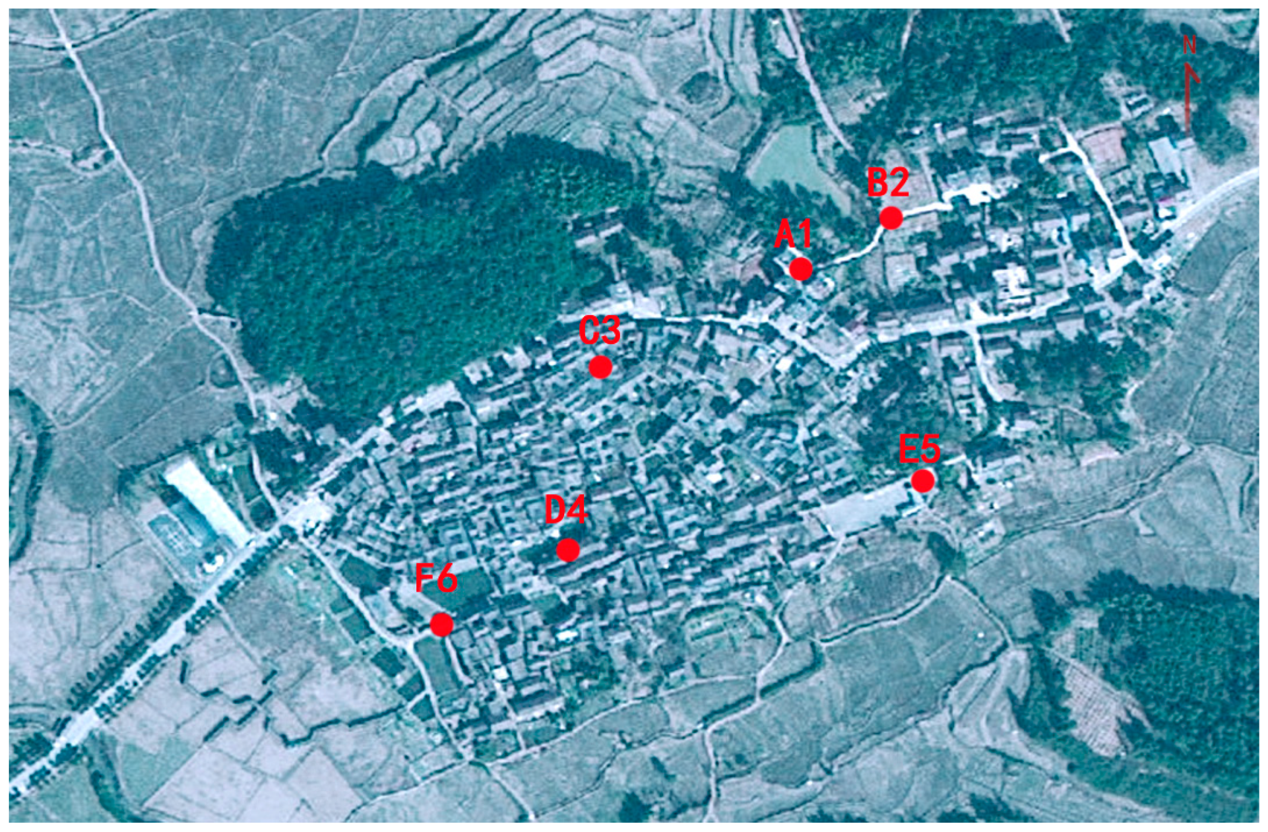
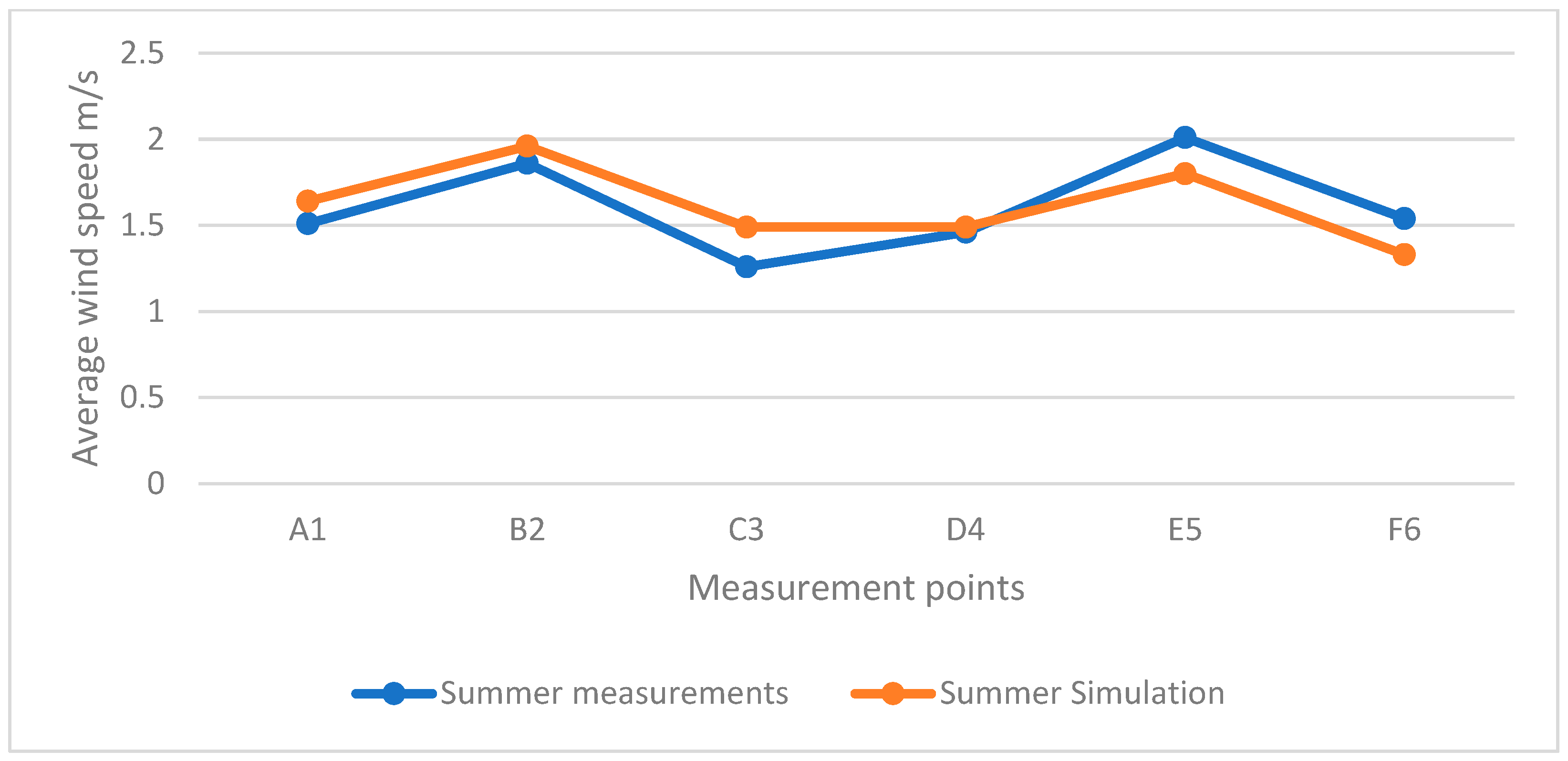
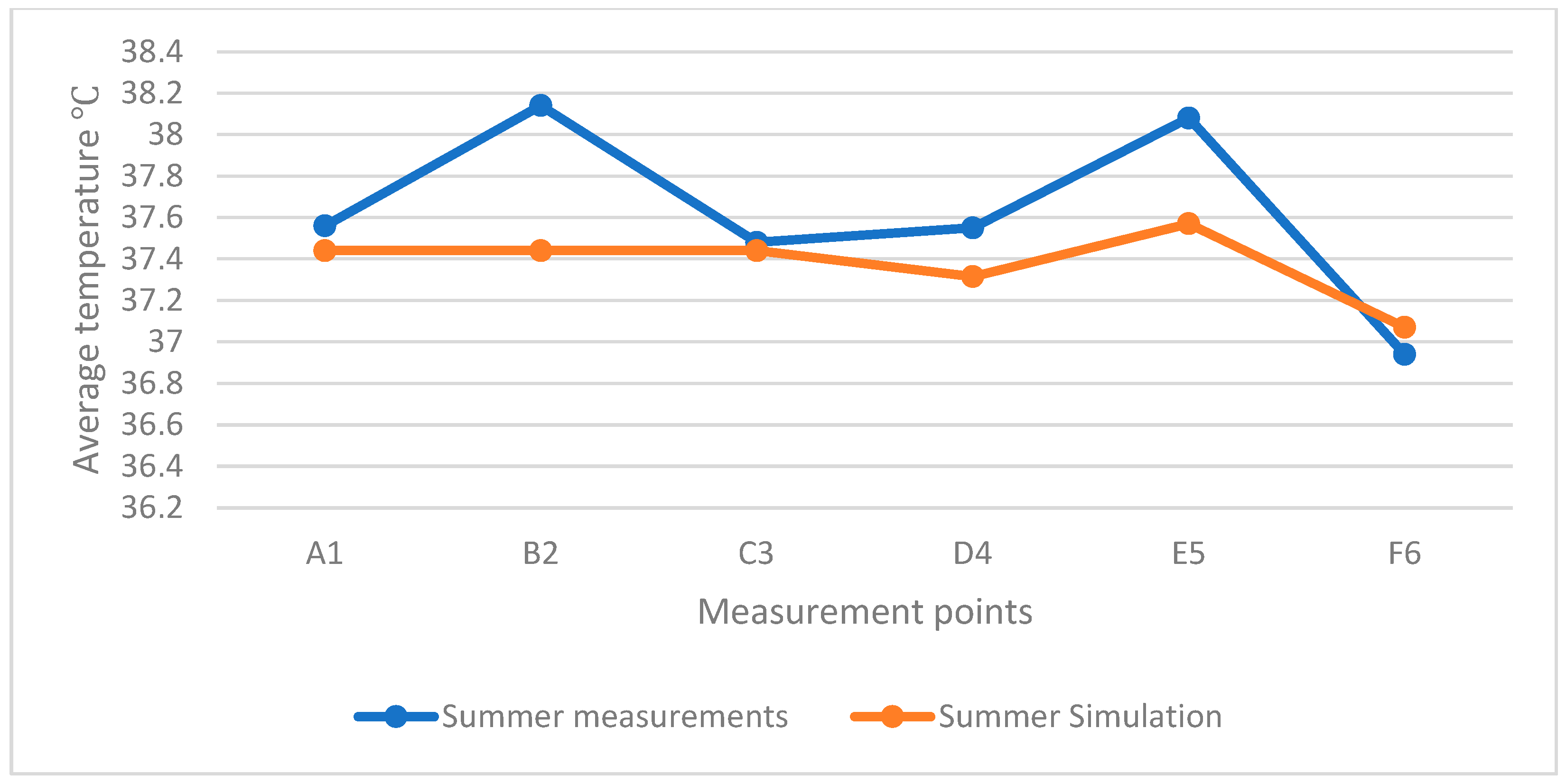
4.1. CFD Validation by Outside Measurement

To verify the applicability of the CFD model and the accuracy of the simulation results, field measurements of the wind and thermal environments were conducted in the Zhuqiao village. Then, the measured data, as an incoming flow condition, was imported into PHOENICS to verify whether the errors between the simulated and measured data were within acceptable limits.
The field measurements were carried out at 08:30–15:30 on 21–28 August 2022, during a typical hot summer climate. In measuring the outdoor wind speed and temperature, six representative positions were selected, The six measurement points are A1,B2,C3,D4,E5,F6 (Figure 4). At 1.5 m above the positions, we measured three measurements once every hour and then took the average value. The wind speed was measured by a PROVA AVM-01 anemometer with the range of 0.3–45.0 m/s, the accuracy of 0.1 m/s and a ±3% margin of error, while the outdoor temperature was measured by an LSI ELR510s thermal comfort sensor with a temperature probe, of which the measurement range was −5–60 °C with an accuracy of 0.1 °C and a 2% margin of error.

Error Analysis of Measured and Simulated Data

After simulated by PHOENICS with the simulated data, including wind speed, wind direction and temperature from the Jinxi Meteorological Service as incoming flow conditions, the simulated results were compared with the measured results (Figure 5).
To verify the accuracy of the average values of the simulated data, the root mean square error (RMSE) was calculated for the measured data. The results showed that in each measured position, the maximum RMSE for wind speed was 1.78 and the maximum for temperature was 0.78, which indicated that, in both measurements, the error trends were stable and proved that the average values were reliable.
To further analyze the error between the measured and simulated date, the mean absolute percentage error (MAPE) analysis was conducted (Table 5). The result showed that the majority of the MAPE values of the measured and simulated data were concentrated between 1–12%, with few reaching over 15% and below 1%.
In terms of the wind environment, all variations at the measuring positions were below 0.23 m/s and the trend remained consistent (Figure 6). Both the measured and simulated MAPE values of C3 and F6 were relatively large, for the measured positions were placed in a lane with dense traditional buildings, while in the simulation the physical models adopted a simplified model excluding the interior spatial layout of the village. In reality, the shelter from constructions in the field had a significant impact on wind speed.
In terms of the thermal environment, the variation of each measuring point was below 0.7 °C (Figure 7). At B2 and E5, the measured and simulated MAPE values were relatively large, since they were in open spaces without shelter. In the simulation, solar radiation was not taken into account, while in reality, it would affect the measurement causing errors to appear.
In addition, considering numerous influence factors, including population, greenery, etc. could escalate the complexity and volatility of the wind environment in field measurements, but the simulated and measured results were in good agreement, indicating that the CFD model simulation was a feasible study methodology.

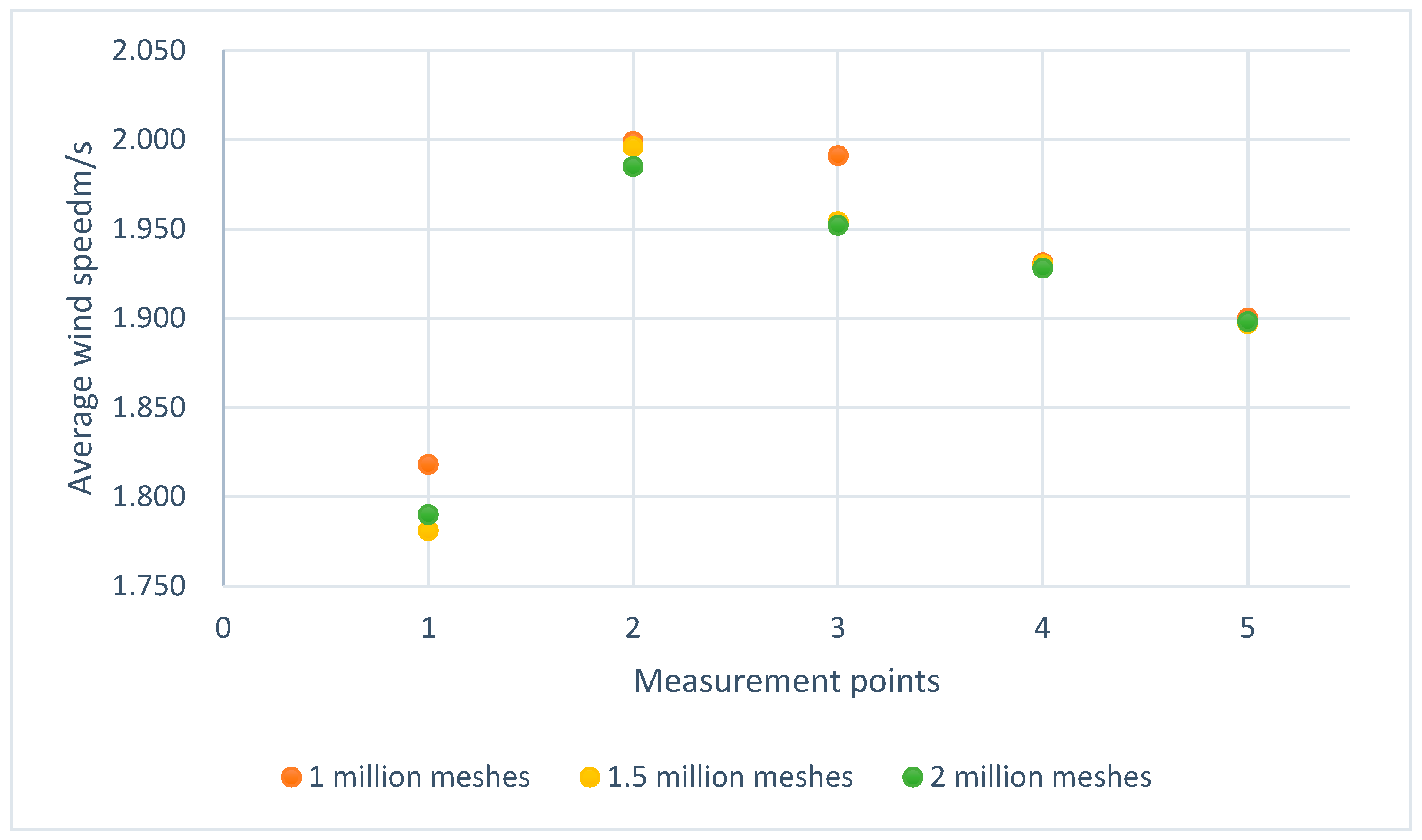
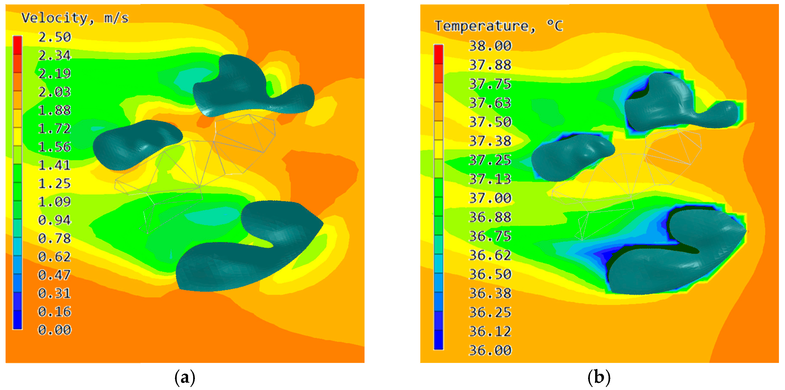
4.2. Verification of the Simulation Results

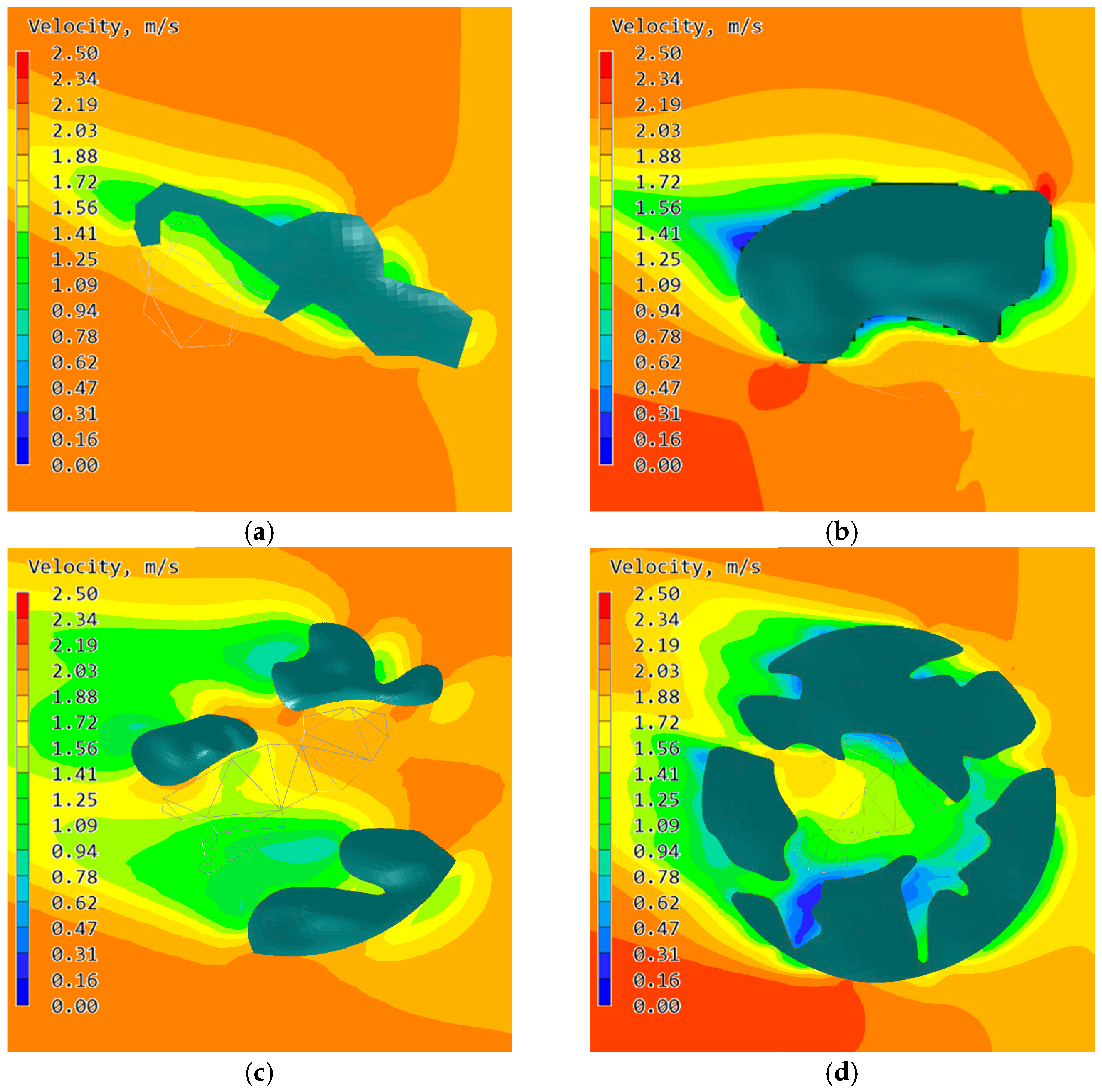
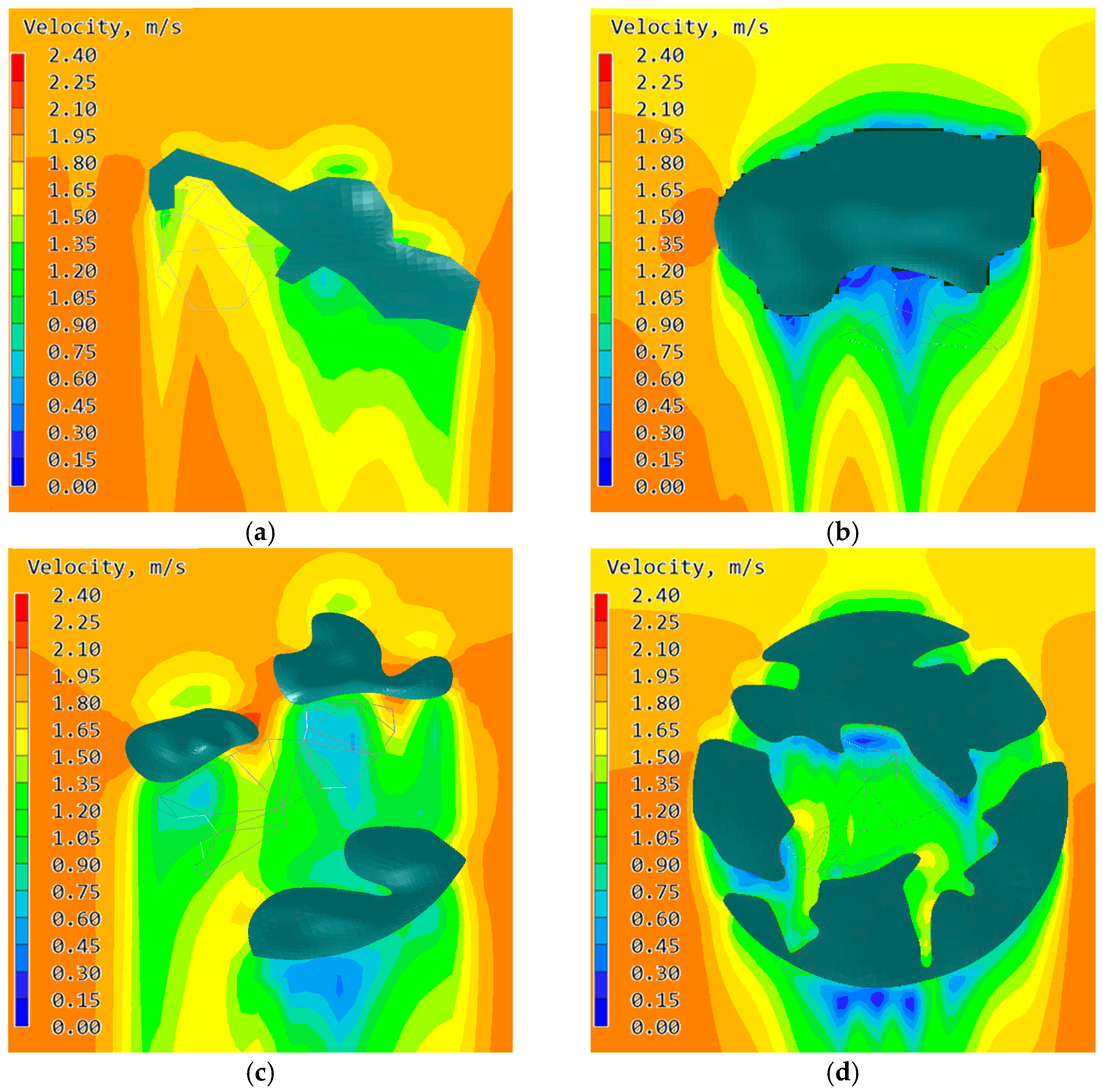
4.2.1. Influence of the Surroundings on the Wind Speed of the Village

To verify how a landscape pattern affected the wind environment of a village in summer and winter, four typical traditional villages and their landscape patterns were stimulated using PHOENICS.
In Jinxi County, during summer, the prevailing wind was a southeastern wind with the incoming flow of 2.1 m/s into the villages. This was known from the wind speed maps of the four villages at 1.5 m above the ground (Figure 8): the wind speed in Xiasong village, with a small manmade water pond in the south, was 1.42–2.03 m/s; the wind speed in Rongfang village, with a river in the southeast, was 1.56–2.03 m/s; the wind speed in Zhuqiao village, with hills in the southeast and ponds in the south, was 1.09–2.03 m/s; the wind speed in the Xuyuan village, located in hillocks with undulating terrain and manmade ponds, was 1.09–1.72 m/s.
Overall, the wind speeds of the four villages were lower than 2.1 m/s, the velocity of incoming flow in Jinxi County. All of the above-mentioned speeds were relatively stable and stayed within the range of 1.09–2.03 m/s without a wind shadow area (wind speed less than 1.0 m/s). According to the Beaufort scale, the speed range could be categorized as light air (0.3 m/s) to light breeze (2.5 m/s). It provided a most pleasant wind environment for the people because it not only enabled outdoor activities with comfortable wind speeds but also ensured circulation and the exchange of airs.
During winter, the prevailing wind was a north–northwesterly wind with an incoming flow of 1.9 m/s. Figure 9 depicts the wind speed at 1.5 m above the ground in the four villages, when the cold north wind blew into the villages passing by the hills and water around: the wind speed in Xiasong village, with a Feng Shui forest in the north was 1.50–1.80 m/s; the wind speed in Rongfang village, with huge hills in the north was 0.30–1.05 m/s; the wind speed in Zhuqiao village, with hills in the north was 1.05–1.65 m/s; and the wind speed in Xuyuan village, with surrounding rolling hills was 0.90–1.65 m/s.
Overall, the wind speeds of the four village were lower than 1.9 m/s, the velocity of the incoming flow in Jinxi County. The wind speeds, in the villages, except for Rongfang village, were relatively stable within the range of 1.09–1.80 m/s. Considering wind below 0.5 m/s cannot remove pollutants, and the lower the wind speed is, the warmer the environment, an ideal wind speed should be close to, yet larger than 0.5 m/s. Therefore, lowering of the wind speed appropriately can cut the heating cost in villages, while natural ventilation can eliminate exhaust from heating and daily use.
According to the results, in both summer and winter, all four types of villages can improve their wind environments to various extents on account of their respective landscape patterns. In summer with the southeasterly wind as the dominant wind, the wind speed in Xiasong and Rongfang villages without hills in southeast reduced by 0.4–0.5 m/s, which was significantly smaller than in the Zhuqiao and Xuyuan villages with hills in the southeast. Therefore, hills in the predominant monsoon direction can remarkably affect the wind environment of a village. In winter with the northerly wind as the dominant wind, the wind speed in the Xuyuan and Zhuqiao villages, reduced more than that in Xiasong village for its Feng Shui forest in the north was not as effective as the hills in blocking wind. In Rongfang village, especially, the wind speed saw the largest decrease with its wind speed of <0.5 m/s.
In conclusion, the distribution of hills around a village is a major factor impacting wind speed. In Feng Shui, the Zhen Shan strategy plays a vital role in site selection. Zhen Shan should conform to the prevailing wind in summer but against the prevailing winds in winter. For example, the Feng Shui forest in Xiasong village made up for the lack of hills in the north and exemplified the importance of the Zhen Shan strategy to the village’s physical environment.

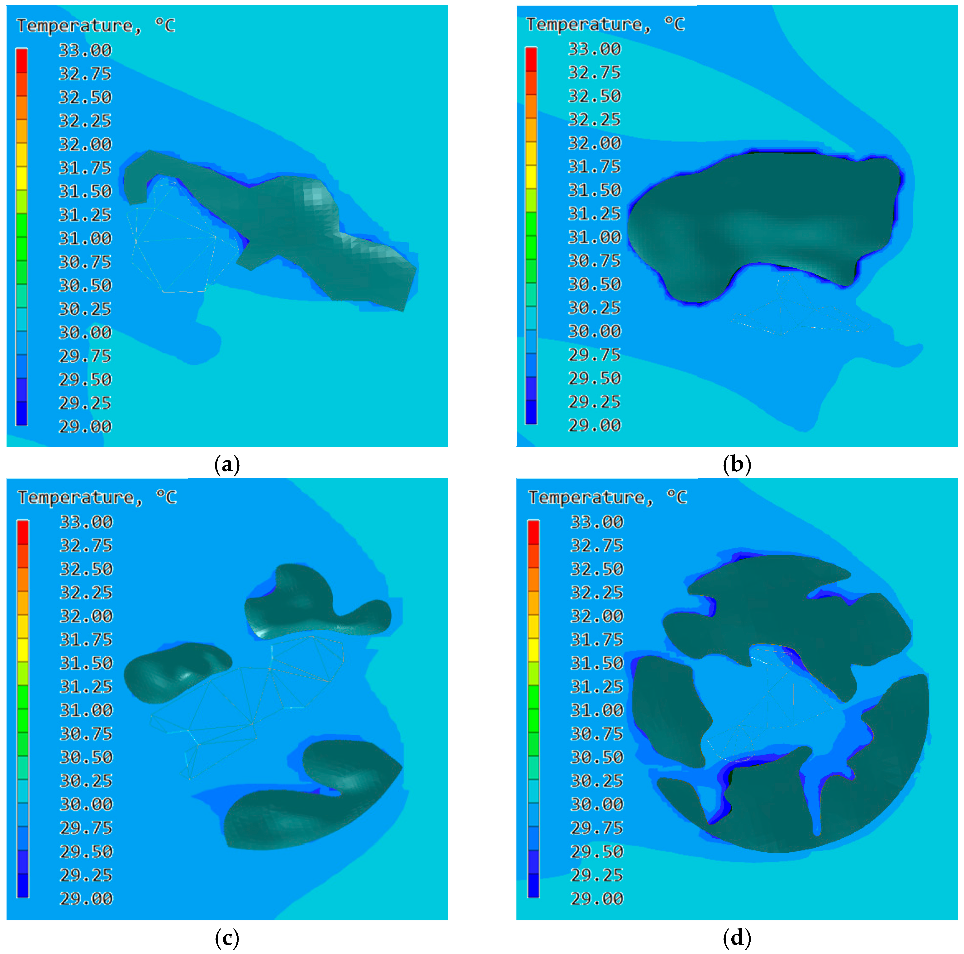
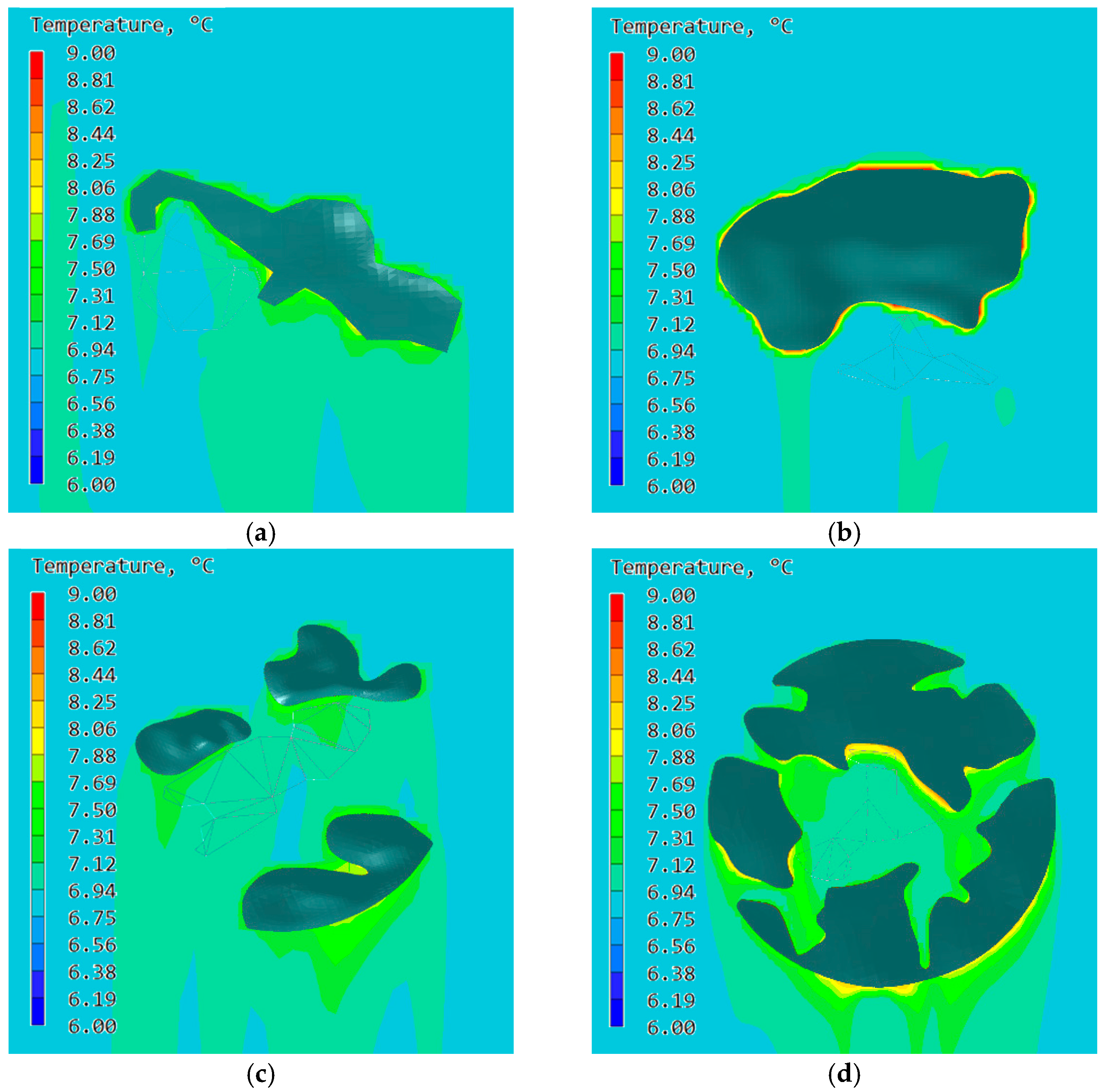
4.2.2. The Influence of the Surroundings on the Temperature of the Village

To verify how a landscape pattern affected the thermal environment of a village in summer and winter, four typical cases were simulated using PHOENICS.
In Jinxi County, the average air temperature in July was 30.1 °C. When the warm and humid southeasterly wind blew into the villages passing by the hills and waters around, the air temperatures at 1.5 m above ground were 29.75–30.00 °C in the Xiasong village, 29.50–29.75 °C in Rongfang village, 29.50–30.00 °C in Zhuqiao village, and 29.50–29.75 °C in Xuyuan village (Figure 10).
Overall, the air temperatures of the four villages were lower than 30.1 °C, the temperature of the incoming flow in Jinxi County. The air temperature reduced by 0.10–0.35 °C in Xiasong village, 0.35–0.60 °C in Rongfang village, 0.10–0.60 °C in Zhuqiao village and 0.35–0.60 °C in Xuyuan village. This meant that the hills and waters around a village can lower the temperature. However, the small volume of rivers and ponds and the relatively flat topography in the south cannot significantly affect the moist southeasterly winds in summer.
In winter, the average air temperature was 6.5 °C. When the cold northerly wind blew into the villages passing by the northern hills, the air temperatures 1.5 m above the ground were 6.75–7.12 °C in Xiasong village, 6.75–6.94 °C in Rongfang village, 6.94–7.31 °C in Zhuqiao village and 6.94–7.31 °C in Xuyuan village (Figure 11).
Overall, the air temperatures of the four villages were higher than 6.5 °C, the temperature of the incoming flow in Jinxi County. The air temperature increased by 0.25–0.62 °C in Xiasong village, 0.25–0.44 °C in Rongfang village, 0.44–0.81 °C in Zhuqiao village and 0.25–0.62 °C in Xuyuan village. Since hills and water around a village can generate heat and hold it, the incoming flow within a village was relatively warmer than in the outside, thus providing heat to the village. In this regard, the landscape pattern can improve the temperature to some extent.
According to the results, in both summer and winter, all types of villages improved their thermal environments to various extents on account of their respective landscape patterns. In summer with the southeasterly wind as the dominant wind, villages were ranked by the decrease in temperature: Rongfang village = Xuyuan village > Zhuqiao village > Xiasong village, which can be explained as follows. Both Xuyuan and Rongfang villages have hills and waters in the southeast; Zhuqiao village has hills and ponds in the southwest, which is closer to the south, Xiasong village has a river in the west and manmade ponds in the southeast to make up for lack of water there. In winter with the northerly wind as the dominant wind, villages were ranked by the increase in temperature: Zhuqiao village > Xuyuan village = Xiasong village > Rongfang village. The air temperature in Zhuqiao village increased most in comparison with the other three villages for the hills to the north warmed up the incoming flow, while the hills in the south retained it within the village. Therefore, in summer, the hills and waters in the direction of the incoming flow can lower the temperature in a village; in winter, the distribution of hills in the incoming flow as well as against it can improve the temperature. In the view of Feng Shui, “Zhen Shan, Huan Shui and Mian Ping” are integral parts. For example, the manmade ponds in Zhuqiao and Xuyuan villages made up for the lack of water. It reflects the ancient people’s pursuit of Feng Shui and the role of Feng Shui theory in improving the physical environment of the village.

5. Conclusions

The case study confirmed that the presence of hills, water and vegetation, to a certain extent can improve the microclimate of villages.
(1) On the wind environment, hills, water and vegetation around villages can effectively reduce wind velocity in summer and winter with hills playing the most significant role. When hills are in the windward direction, they can adjust wind velocity effectively. Therefore, in the historic villages in Jiangxi Province, the Zhen Shan strategy can adapt the local climate and geographical environment and play a positive role in adjusting the internal wind environment of the villages.
(2) On the thermal environment, during summer, the temperature in villages can be lowered by the hills, water and vegetation around, among which water and vegetation can effectively reduce the temperature through evaporation. According to relevant research, when the direction of water is paralleled with that of the summer prevailing wind, it works best. Therefore, the Huan Shui strategy was used to adjust the thermal environment of villages in site selection in ancient time. During winter, the heat source of a villages is the surrounding hills which effectively block the northerly wind, and keep the wind speed stable, so as to adjust the internal temperature of the village. For this reason, the Mian Ping strategy can improve the thermal environment.
(3) Among the four types of villages, both ideal settlements and artificial environment benefit the physical environment of villages, proving the positive effect of hills and water on improving the wind and thermal environment of villages and the rationality of the site selection principle of Bei Shan Mian Shui in Feng Shui.
To conclude, Feng Shui, as an intangible culture in China, make settlements to integrate into the natural environment as an organic whole [35]. Feng Shui, like a sustainable ecological awareness, was used in site selection by ancient Chinese people. Additionally, we can also add traditional wisdom to explore sustainable development strategies that are adaptable to climate change. In the realm of modern planning, such as how ancient people created traditional villages, we can use the natural environment as well as manmade interventions to improve the microclimate.
Hence, using traditional Chinese wisdom in construction to create a sustainable living environment that adapts to the climate is relevant today. At the same time, it was found during the study that the layout pattern of the internal spaces of villages can also affect its physical environment, which will be further studied in the future.

Author Contributions

Conceptualization, Z.Z.; methodology, K.M.; software, P.W. and Y.X.; validation, P.W. and J.D.; formal analysis, J.D.; investigation, C.Z. and P.W.; writing—original draft preparation J.D.; writing—review and editing K.M.; supervision, W.J. All authors have read and agreed to the published version of the manuscript.

Funding

This research received no external funding.

Institutional Review Board Statement

Not applicable.

Informed Consent Statement

Not applicable.

Data Availability Statement

Not applicable.

Conflicts of Interest

The authors declare no conflict of interest.

References

  1. Chun, B.; Guldmann, J.-M. Spatial statistical analysis and simulation of the urban heat island in high-density central cities. Landsc. Urban Plan. 2014, 125, 76–88. [Google Scholar] [CrossRef]
  2. Perini, K.; Magliocco, A. Effects of vegetation, urban density, building height, and atmospheric conditions on local temperatures and thermal comfort. Urban For. Urban Green. 2014, 13, 495–506. [Google Scholar] [CrossRef]
  3. Wolch, J.R.; Byrne, J.; Newell, J.P. Urban green space, public health, and environmental justice: The challenge of making cities ‘just green enough’. Landsc. Urban Plan. 2014, 125, 234–244. [Google Scholar] [CrossRef] [Green Version]
  4. Chen, J.; Lin, W.; Zhang, Y.; Dai, Y.; Chen, B. Village Fengshui Forests as Forms of Cultural and Ecological Heritage: Interpretations and Conservation Policy Implications from Southern China. Forests 2021, 11, 1286. [Google Scholar] [CrossRef]
  5. Chen, X.; Wu, J. Sustainable landscape architecture: Implications of the Chinese philosophy of “unity of man with nature” and beyond. Landsc. Ecol. 2009, 24, 1015–1026. [Google Scholar] [CrossRef]
  6. Pan, Y.; Shi, Y. On the pattern characteristics of the layout of traditional settlements in Jiangxi. J. Nanchang Univ. Humanit. Soc. Sci. Ed. 2007, 3, 94–98. [Google Scholar]
  7. Zhang, Z. The composition of “local knowledge” and its application in traditional village landscapes: The case of Shaanxi. Soc. Sci. 2017, 7, 112–117. [Google Scholar]
  8. Li, J.; Lin, H.; Chen, J.; Li, D.; He, Q. The spatial and temporal evolution of traditional villages in Fuzhou City and its influencing factors. Surv. Mapp. Sci. 2021, 46, 190–196. [Google Scholar]
  9. Duan, Y. Study on the Spatial Form of Traditional Settlements in the Fuhe River Basin Area, 1st ed.; China Construction Industry Press: Beijing, China, 2017; pp. 44–52. [Google Scholar]
  10. Traditional Village Network. Available online: http://www.chuantongcunluo.com/index.php/Home/gjml/gjml/wid/586 (accessed on 20 September 2022).
  11. Mak, M.Y.; Ng, S.T. The art and science of Feng Shui—A study on architects’ perception. Build. Environ. 2005, 40, 427–434. [Google Scholar] [CrossRef]
  12. Ramponi, R.; Blocken, B. CFD simulation of cross-ventilation for a generic isolated building: Impact of computational pa-rameters. Build. Environ. 2012, 53, 34–48. [Google Scholar] [CrossRef]
  13. Blocken, B.; van der Hout, A.; Weiler, O. CFD simulation of wind flow over natural complex terrain: A case study with val-idation by field measurements for Ria de Ferrol, Galicia, Spain. J. Wind. Eng. Ind. Aerodyn. 2015, 147, 43–57. [Google Scholar] [CrossRef]
  14. Yuan, C.; Ng, E. Practical application of CFD on environmentally sensitive architectural design at high density cities: A case study in Hong Kong. Urban Clim. 2014, 8, 57–77. [Google Scholar] [CrossRef] [PubMed]
  15. Hang, J.; Li, Y.; Sandberg, M.; Buccolieri, R.; Di Sabatino, S. The influence of building height variability on pollutant dispersion and pedestrian ventilation in idealized high-rise urban areas. Build. Environ. 2012, 56, 346–360. [Google Scholar] [CrossRef]
  16. Mochida, A.; Lun, I. Prediction of wind environment and thermal comfort at pedestrian level in urban area. J. Wind. Eng. Ind. Aerodyn. 2008, 96, 1498–1527. [Google Scholar] [CrossRef]
  17. Shi, X.; Zhu, Y.; Duan, J.; Shao, R.; Wang, J. Assessment of pedestrian wind environment in urban planning design. Landsc. Urban Plan. 2015, 140, 17–28. [Google Scholar] [CrossRef]
  18. Ramponi, R.; Blocken, B.; Coo, L.B.; Janssen, W.D. CFD simulation of outdoor ventilation of generic urban configurations with different urban densities and equal and unequal street widths. Build. Environ. 2015, 92, 152–166. [Google Scholar] [CrossRef] [Green Version]
  19. Kang, G.; Kim, J.J.; Choi, W. Computational fluid dynamics simulation of tree effects on pedestrian wind comfort in an urban area. Sustain. Cities Soc. 2020, 56, 102086. [Google Scholar] [CrossRef]
  20. Meaden, G.T.; Kochev, S.; Kolendowicz, L.; Kosa-Kiss, A.; Marcinoniene, I.; Sioutas, M.; Tooming, H.; Tyrrell, J. Comparing the theoretical versions of the Beaufort scale, the T-Scale and the Fujita scale. Atmos. Res. 2007, 83, 446–449. [Google Scholar] [CrossRef]
  21. Dimoudi, A.; Nikolopoulou, M. Vegetation in the urban environment: Microclimatic analysis and benefits. Energy Build. 2003, 35, 69–76. [Google Scholar] [CrossRef] [Green Version]
  22. Yao, X.; Han, S.; Dewancker, B. Wind Environment Simulation Accuracy in Traditional Villages with Complex Layouts Based on CFD. Environ. Res. Public Health 2021, 18, 8644. [Google Scholar] [CrossRef]
  23. Tang, L.; Nikolopoulou, M.; Zhang, N. Bioclimatic design of historic villages in central-western regions of China. Energy Build. 2014, 70, 271–278. [Google Scholar] [CrossRef]
  24. Tang, L.; Nikolopoulou, M.; Zhao, F.; Zhang, N. CFD modeling of the built environment in Chinese historic settlements. Energy Build. 2012, 55, 601–606. [Google Scholar] [CrossRef]
  25. Zhao, J.; Hu, S. Research on the wind environment of traditional village streets in hot-summer and cold-winter areas: The example of Shangfeng Village in Daye City, Hubei Province. New Archit. 2021, 4, 139–143. [Google Scholar]
  26. Chu, Y.C.; Hsu, M.F.; Hsieh, C.M. An example of ecological wisdom in historical settlement: The wind environment of Huazhai village in Taiwan. Asian Archit. Build. Eng. 2017, 16, 463–470. [Google Scholar] [CrossRef]
  27. Wang, Z.; Wang, Y.; Wu, G.; Lu, T. Simulation analysis of wind environment in traditional villages under natural ven-tilation conditions: An example of Quanfang village in Jinxi County. Urban Archit. 2022, 19, 20–22. [Google Scholar]
  28. Tang, L.; Zhang, N. A study on the thermal environment of historical villages with a ‘comb-like’ layout in southern China. Indoor Built Environ. 2018, 27, 658–664. [Google Scholar] [CrossRef]
  29. Toparlar, Y.; Blocken, B.; Vos, P.; Van Heijst, G.J.F.; Janssen, W.D.; van Hooff, T.; Montazeri, H.; Timmermans, H.J.P. CFD simulation and validation of urban microclimate: A case study for Bergpolder Zuid, Rotterdam. Build. Environ. 2015, 83, 79–90. [Google Scholar] [CrossRef]
  30. Gao, Y.; Cheng, J.; Wang, Z. A computer analysis of the ecophysical environment of villages with ideal Feng Shui pattern. Build. Sci. 2007, 6, 19–23. [Google Scholar]
  31. Qi, L.; Ma, Z.; Zhang, Y.; Liu, J. Research on the landscape pattern of Shuiyu Village in Jingxinanjiaoxiang based on microclimate adaptation design. Landsc. Archit. 2018, 25, 38–44. [Google Scholar]
  32. Zhou, H. A discussion of the types of historical and cultural villages and towns in China based on the perspective of tra-ditional functions. Chin. Agric. Hist. 2009, 28, 92–101. [Google Scholar]
  33. Li, P.; Li, Z.; Min, Z. Exploring the characteristic patterns of historical site selection of ancient villages in Jiangxi and their comprehensive reasons. Urban Dev. Inq. 2018, 25, 131–136. [Google Scholar]
  34. Bergman, T.L.; Lavine, A.S.; Incropera, F.P.; DeWit, D.P. Fundamentals of Heat and Mass Transfer, 8th ed.; Wiley: Hoboken, NJ, USA, 2018; pp. 341–382. [Google Scholar]
  35. Wang, Q. Studies in Feng Shui Theory, 2nd ed.; Tianjin University Press: Tianjin, China, 2005; pp. 44–52. [Google Scholar]
Figure 1. Ideal siting pattern for villages. Source: [11].
Processes 10 02453 g001
Figure 2. Distribution of 62 traditional villages in Jinxi County.
Processes 10 02453 g002
Figure 3. Grid independence verification.
Processes 10 02453 g003
Figure 4. Measured positions in Zhuqiao village. (The red marks are the locations of the actual measurement points.)
Processes 10 02453 g004
Figure 5. (a) Simulation of the summer wind environment in Zhuqiao village; (b) Simulation of the summer thermal environment in Zhuqiao village.
Processes 10 02453 g005
Figure 6. Comparison of the measured and simulated summer wind environment in Zhuqiao village.
Processes 10 02453 g006
Figure 7. Comparison of the measured and simulated summer thermal environment in Zhuqiao village.
Processes 10 02453 g007
Figure 8. (a) Summer wind speed simulation in Xiasong village; (b) Summer wind speed simulation in Rongfang village; (c) Summer wind speed simulation in Zhuqiao village; (d) Summer wind speed simulation in Xuyuan village.
Processes 10 02453 g008
Figure 9. (a) Winter wind speed simulation in Xiasong village; (b) Winter wind speed simulation in Rongfang village; (c) Winter wind speed simulation in Zhuqiao village; (d) Winter wind speed simulation in Xuyuan village.
Processes 10 02453 g009
Figure 10. (a) Summer thermal environment simulation in Xiasong village; (b) Summer thermal environment simulation in Rongfang village; (c) Summer thermal environment simulation in Zhuqiao village; (d) Summer thermal environment simulation in Xuyuan village.
Processes 10 02453 g010
Figure 11. (a) Winter thermal environment simulation in Xiasong village; (b) Winter thermal environment simulation in Rongfang village; (c) Winter thermal environment simulation in Zhuqiao village; (d) Winter thermal environment simulation in Xuyuan village.
Processes 10 02453 g011
Table 1. Classification of the landscape pattern of traditional villages in Jinxi County.
CategoryLandscape PatternSchematicDefine IndicatorsName
Type 1The village is on a plain, surrounded by rivers, and there are no hills around it. Therefore, Feng Shui forests have been planted to replace the function of hillsProcesses 10 02453 i001Within a 500 m radius of the village slope <3%, water area >20%Shukou village, Wuduntang village, Gongjia village, Putang village, Huwan village, Shimen village, Huangfang village, Chenghu village, Gaoping village, Louxia village, Hufang village, Zhongling village, Zhengfang village, Xiasong village, Pengjia village, Lufang village, Tonglling village, Fujia village, Yangfang village, Hengyuan village, Zhongzhou village, Sunfang village, Qiujia village, Hangqiao village, Chemen village, Tufang village
Type 2The location of the village fit Bei Shan Mian Shui, with a hill in the north and a water source in the southProcesses 10 02453 i002Within a 500 m radius of the village, slope in the range of 3–8%, water area in the south of the village >20%Quanfang village, Yinshan village, Qishan village, Yangtian village, Houche village, Xiali village, Qiaoshang village, Hushan village, Jingsi village, Hengyuan village, Rongfang village, Pengjiadu village, Shangzhuang village, Kingfang village
Type 3The village is located on both a plain and hillocks, surrounded by fields and forests. without enough water sources, so people dug ponds aroundProcesses 10 02453 i003Within 500 m radius of the village, slope in the range of 3–8%, water area <20%Zhuqiao village, Donggang village, Zengjia village, Dageng village, Beikeng village, Xuyuan village, Xiefang village, Shangzhang village, Zhiyuan village, Hougong village, Zhongsong village, Fengling village, Boyuan village, Aotang village, Qifang village, Houling village
Type 4The village is in hillocks without enough water sources, so people dug ponds aroundProcesses 10 02453 i004Within 500 m radius of the village, terrain undulating, slope in the range of 3–8%, water area <20%Youdian village, Lijiang village, Chonglu village, Fuzhu village, Xuyuan village, Gulouxia village, Huyang village
Table 2. Four types of village siting patterns and physical models.
NameVillage FeaturesSatellite Image Map of the VillageSimplified Physical Model
Xiasong
village
Type 1, the village is on a plain without hills. A river is to the west, and a Feng Shui forest was planted on the northeast to satisfy the Zhen Shan strategyProcesses 10 02453 i005Processes 10 02453 i006
Rongfang
village
Type 2, around the village, there are hills to the north, a river to the southeast, and manmade ponds to the west and southeast for daily water supply Processes 10 02453 i007Processes 10 02453 i008
Zhuqiao
village
Type 3, there are hills to the north and south of the village, and water resources are limited here. Under the guidance of Feng Shui, people dug ponds at the front of the village, as well as around itProcesses 10 02453 i009Processes 10 02453 i010
Xuyuan
village
Type 4, around the village, the terrain is undulating, and water resources are limited. To meet the requirement of Feng Shui, a great number of ponds have been dug Processes 10 02453 i011Processes 10 02453 i012
Table 3. Temperature of the main boundaries.
SeasonInlet (°C)Hills (°C)Water (°C)
Summer30.128.1627
winter6.59.8811
Table 4. Material property settings.
CategoryEmissivityHeat Transfer Coefficient
(W/(m·°C))
Thickness (m)
soil0.91.22
vegetation0.9104
Table 5. Measured and simulated MAPE values (%) in summer in Zhuqiao village.
ParameterA1B2C3D4E5F6
Wind speed7.75.115.32.111.815.6
Temperature0.31.90.10.61.40.4
Publisher’s Note: MDPI stays neutral with regard to jurisdictional claims in published maps and institutional affiliations.

