Review

The Impacts of Urbanisation and Climate Change on the Urban Thermal Environment in Africa

1
Department of Environment and Geography, University of York, York YO10 5NG, UK
2
Sustainability Research Institute, School of Earth and Environment, University of Leeds, Leeds LS2 9JT, UK
*
Author to whom correspondence should be addressed.
Climate 2022, 10(11), 164; https://doi.org/10.3390/cli10110164
Submission received: 16 September 2022 / Revised: 15 October 2022 / Accepted: 20 October 2022 / Published: 30 October 2022

Abstract

:
Rapid urbanisation is affecting people in different ways, with some becoming more vulnerable to the impacts of climate change. Africa’s cities are projected to be home to nearly 60% of the continent’s population by 2050. In conjunction with climate change, these cities are experiencing critical environmental challenges, including changes in the urban thermal environment. Urban areas generally exhibit significantly higher air and surface temperatures than their surrounding rural areas, resulting in urban heat islands. However, little has been done to synthesise existing knowledge and identify the key research gaps in this area, particularly in Africa. This paper focuses on the combined effects of urbanisation and climate change on the urban thermal environment in Africa, and provides a comprehensive review of results, major advances and the dominant direction of research. Our review of 40 publications from peer-reviewed journals from 2000 to 2021 revealed that South Africa, Ethiopia and Nigeria were most frequently studied, and satellite imagery-based data and analysis were used predominantly. Results from a few studies have shown the practical implications for urban land-use planning, informal settlement management, human wellbeing and productivity, energy use, air pollution and disease spread. Integrated approaches, strengthening planning institutions, and early warning systems are proposed to address climate change. Low-income groups are emphasised in efforts to help people cope with heat stress. Solutions based on land use and land cover dynamics and blue–green infrastructure are mentioned but are in need of further research. Cities with similar patterns of urbanisation, geographies and climate conditions could benefit from multi-disciplinary research collaboration to address the combined impacts of rapid urbanisation and climate change.

1. Introduction

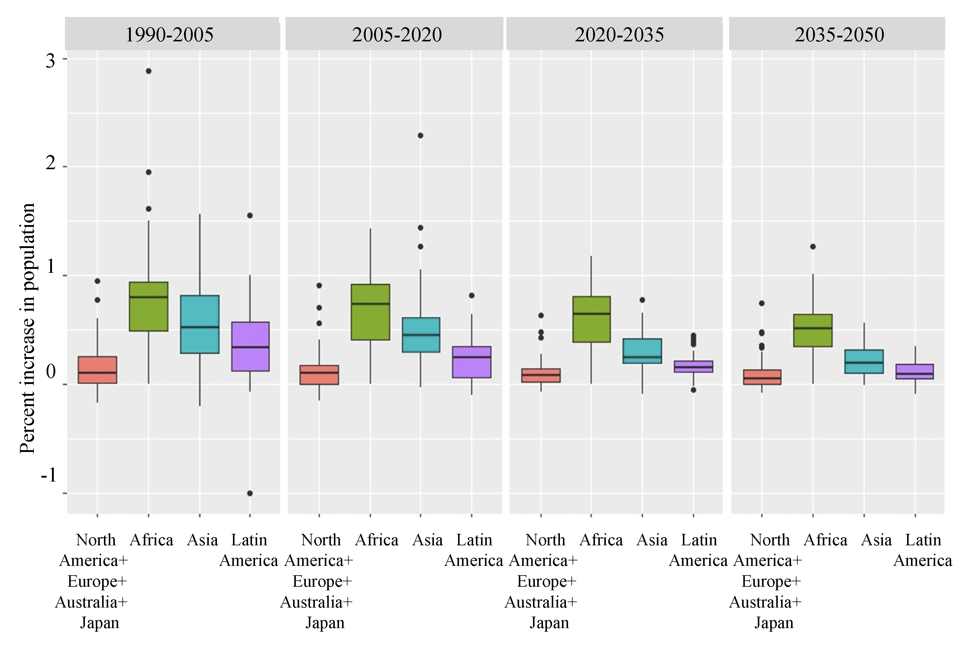
1.1. Global Urbanisation and Climate Change

Urbanisation is a global phenomenon. The proportion of the world’s population living in urban areas was only 30% in 1950 but reached 55% in 2018, and is projected to be 68% by 2050 [1]. These dramatic shifts have substantial impacts on people, the environment and development [2], across local, regional and global scales [3,4]. Changes include air and water pollution [5,6], land use [7], biodiversity loss [8], and ecosystem degradation [9,10,11], while carbon emissions from cities and associated land use changes are becoming an important driver of climate change [12]. This urban growth dynamic is not homogeneous, and urban expansion patterns differ markedly across developing countries [13]. By 2050, the number of urban dwellers will increase by 2.5 billion, with nearly 90% of this growth happening in Asia and Africa [1].
Africa is experiencing rapid population growth (Figure 1), especially in the East and West (Figure 2). According to the OECD [14], approximately 4500 new cities emerged in Africa between 1990 and 2015. In parallel, urban populations grew by approximately 500 million people between 1990 and 2020. Urbanisation has boosted economic outcomes and living standards for many; helping hundreds of millions of people to move out of economically under-performing rural areas to benefit from better opportunities in urban centres [14]. Cities in these countries are undergoing dramatic spatial, social, economic and environmental transformations [15,16], due to a combination of multiple factors such as resource availability [17], technological innovation processes [18], the circulation of global capital [19], and the impact of climate change on primary production activities [20,21]. This has meant that as people have moved from rural to urban areas, many cities in Africa have grown in an unplanned manner, with a mix of commercial centres, industrial areas, residential communities, informal settlements and agricultural lands [22,23].
Three major urban forms were detected for African cities in 2015: first, the transitional urban form, characterised by built-up sprawling urbanisation and a decrease in open space, as seen in Accra, Addis Ababa, Bamako, Cairo, Gombe, Ibadan, Khartoum. Kigali, Luanda, Marrakesh and Port Elizabeth. The second type of urban form is the compact-grey form. This kind of city has become even more compact and simple in shape, and includes cities such as Alexandria, Kairouan, Oyo, Tebessa. The third type is the ragged-small form, which is less irregular and complex in shape, with examples including Arusha, Beira, Nakuru and Ndola [24]. Cities under these different urban forms are projected to experience various changes as they expand further, offering the opportunity for more sustainable planning, but also presenting a challenge [1]. Data from the World Bank shows African cities are growing at a rate that is out of sync to real economic growth [25]. Due to rapid rural–urban transformation and the continuous influx of rural–urban migrants, the situation limits cities’ ability to reduce poverty and provide improved standards of living [26]. Despite the economic gains made for many who moved to urban centres, millions of people in the cities of Africa lack access to resources and facilities to meet their essential needs, such as shelter, water, food, health, and education [27]. Over 59% of the urban population in sub-Saharan Africa is estimated to be living in informal settlements [28]. While the fact that cities are perceived to offer more economic opportunities still pulls many people to live in cities. However, doing so increases their exposure to climate impacts [29].
Africa is particularly vulnerable to climate change [29] and extreme temperature increases have been recorded in most of the continent. The rising rate of temperature increases is higher than at the global level, and even double that of some areas [30]. Africa’s climate is highly diverse and variable [30,31,32]. Patterns of temperatures and precipitation are being altered by climate change [33], with increased probability and magnitude of extreme events, such as floods, heatwaves, droughts and storms. Changes in annual temperature and precipitation patterns have been nuanced and variable [34], with increasing and decreasing trends in different subregions. Lower precipitation and higher temperatures will likely reduce crop productivity in large parts of the continent [35]. In West Africa, particularly in the Sahel, prolonged dry seasons, shorter wet seasons, and less regular rainfall are contributing to an increase in migration and displacement [36,37]. Lack of structural transformation in Africa’s agriculture inhibits responses to climate change [38]. Events such as the intense outbreak of desert locust (Schistocerca gregaria) across several East African countries from the end of 2019 to early 2020 [39], posed a major threat to food security and livelihoods in addition to the challenge of direct climate change impacts [40]. With few livelihood options in rural areas, climate change in combination with related challenges like food insecurity creates another factor that can push rural migrants to urban areas [32]. West Africa’s coastal cities face especially worrying risks as a result of climate change. “Storm surges and rain-triggered floods are damaging cities, setting back development, and generating the spread of disease that has killed thousands and displaced millions in Benin, Ivory Coast, Senegal, and Togo” [41]. With 85 million people projected to inhabit the coastal cities by 2050 [42], around 6500 km2 of the coastal areas could be severely degraded by rising sea levels [42,43].
East Africa is often considered one of the most climate-vulnerable parts of Africa [44]. The IPCC regional climate report for Africa suggests that mean annual temperatures (1995–2014) are on average, 0.6 °C, 1.1 °C and 2.1 °C warmer than the 1994–2005 average, at 1.5 °C, 2 °C and 3 °C of global warming above the 1850–1900 period [29]. The intensity and frequency of unusually hot days are projected to increase from global warming level (GWL) 2 °C [29]. Compared to the period 1985–2005, the possibility of cities in this region being exposed to dangerous heat grows by 2000 times at GWL 4.6 °C [29]. Based on Statistical Global Climate Models (GCMs) and Down-Scaling Models (SDSM), the projected climate in East Africa shows an increase in maximum and minimum temperature throughout the 21st century [44]. Haile et al. [45] noted that the drought area in East Africa is projected to increase by the end of the 21st century by 16%, 37%, and 54% under Representative Concentration Pathways (RCPs) 2.6, 4.5, and 8.5, via an ensemble of five GCMs in the Coupled Model Intercomparison Project (CMIP5). Growing cities will be hotspots of heat-related risks from climate change, as modification and changes in land use and land cover (LULC) during urbanisation processes intensifies the urban heat island (UHI) effect, and subsequently, exacerbates current and projected heat stress [46]. This is particularly concerning in newly developing urban areas such as East Africa, which is the least urbanised region but with the strongest growth trend [47]. Based on time series observations, a significant rising trend in temperatures has already been recorded in some East African cities. Urbanisation processes, both in terms of urban densification and urban sprawl, will increase the intensity or magnitude of UHIs [48,49], which is expected to place additional stress on health and economic systems in the context of climate change [50]. Thus, it is crucial to investigate urbanisation and climate change together in rapidly changing regions such as East Africa and West Africa.

1.2. Urban Thermal Environment

Due to the combined effects of climate change and rapid urbanisation, the urban thermal environment in African cities is undergoing dramatic changes. Warmer temperatures and increased frequency of extreme events associated with climate change exacerbate how the urban thermal environment is affected by anthropogenic processes [51]. Increasing impervious surfaces and decreasing blue and green spaces in and around urban areas reduce atmospheric moisture contributed by evaporation and transpiration of latent heat flux of urban areas [52,53,54,55]. Urban thermal environment dynamics and impacts can vary significantly with complex interactions between biophysical variables (e.g., breeze circulation, relative humidity, vapor pressure and soil properties) [56,57]. Furthermore, urban areas change the albedo and nocturnal radiation [58], while urban transportation contributes to greenhouse gas emissions that are likely to increase the local temperature [59].
A typical feature associated with urban thermal environmental changes is the formation of the urban heat island (UHI) [60]. UHI refers to the phenomenon of higher urban temperatures than the rural surroundings and affects temperatures in the air and at the surface [61]. Urban inhabitants can be more susceptible to higher heat-related risk than rural residents due to UHI [62]. In 2100, over 300 million African urban residents are projected to be exposed to 15-day heat waves over 42 °C. If we also consider the UHI, this number could potentially be up to 950 million [63]. Higher temperatures can have direct effects and acutely impact the health of vulnerable populations, such as children, the sick, and the elderly [64]; and compound indirect impacts related to productivity loss, disease spread, water shortage, and energy supply disruptions [65]. Additionally, high temperatures exacerbated by UHI will accelerate the formation of urban pollution islands with smog and polluted air [66], exacerbating respiratory diseases [67]. African countries are generally vulnerable to increasing temperatures [50]. These climate impacts have an economic cost and cause a reduction in GDP [68]. Parkes et al. [50] projected that the extra cost in energy consumption to prevent heat stress will be $51.3 billion in Africa between 2005 and 2035, rising to $487 billion by 2076. If meeting the additional energy demand, the whole energy system will raise its cost by 0.6% from 2005 to 2076, which accounts to 0.06% of the GDP in Africa over the same period [50].

1.3. Data Analysis and Tools

The urban thermal environment has traditionally been investigated by using meteorological data, as long-term local monitoring records are particularly important to capture temporal climate variability [69]. For instance, national weather services operating monitoring networks provide historical and current meteorological data in Europe, including information on air temperature, atmospheric pressure, wind speed, humidity and precipitation [70]. For the investigation of small-scale variations, sensors and observational networks have been established to investigate built environment impacts in the urban canopy layer [71]. However, establishing and operating a high-quality monitoring system is often time consuming and expensive, which has led to data scarcity in some regions, such as Africa [72]. Stewart [73] found that less than 5% of the 177 urban climate studies identified focused on African cities.
Temperature maps have nevertheless become more commonly available with advances in thermal infrared and multispectral remote sensing, which provides various-resolution surface temperature distributions to visualize both hot and cold surface spots [74]. A wide range of remote sensing data can give important insights into the spatial dynamics of thermal environment changes, especially in areas with rapid urban expansion and low-density monitoring networks. Examples include observations with the Moderate Resolution Imaging Spectroradiometer (MODIS) instrument aboard the Terra and Aqua satellites, which provides land surface temperature (LST) observations with a spatial resolution of 1000 m, or Landsat data with more precise 30/60m resolutions (Table 1), with increasing datasets becoming available with the launch of new satellites and improved sensors (Figure 3 [75,76]). The National Aeronautics and Space Administration (NASA) and European Space Agency (ESA) now provide free access to data archives, which is promoting and inspiring development of new techniques globally [71,74]. It is worth noting that satellite-based thermal data surface temperatures are different from air temperatures [70]; and the interpretation and fusion of the different data sources can be markedly different [76]. Beyond meteorological observations, remote sensing provides various data for investigating urban structures, land cover, and biophysical characteristics [74]. These urban characteristics are extremely important in understanding the urban thermal environment, especially the relationships between LULC and vegetation indices [77]. Existing remote sensing-based data enable the investigation of temporal and spatial patterns, as well as thermal characteristics, although observations in specific areas can remain challenging. For instance, in the intertropical convergence zone (ITCZ)-dominated regions, cloud contamination may last for several months, resulting in long gaps in useable datasets [78]. These observation challenges are now partly overcome by advanced algorithms via cloud-based platforms (e.g., Google Earth Engine, Planetary Computer), enabling further research.

1.4. Urban Thermal Environment Analysis at Different Scales

Different scale models, based on various data sources, have become fundamental for understanding urban climate processes. Targeting past urban climate dynamics and/or future climate development scenarios, urban climate model simulations can support urban planners to develop optimally cost-effective and science-based solutions for sustainable urban development [79,80]. There is a wide spectrum of models for estimating and describing urban issues on different spatial scales. Regional-scale models have been used to evaluate climate and land use change effects on urban climate across both short-term and long-term temporal scales. These models also enable researchers to understand processes on different spatial scales and interactions with mutually interlinked components (e.g., the atmosphere, land, water bodies, and anthropogenic emissions) [81]. The major aim of regional scale models is to parameterise urban processes to include the modifications in energy balance, which are often unable to provide sufficient information for certain urban development plans [82,83]. City-scale models focus on the area of one or a few cities, which enable the simulation of atmospheric and surface processes to meet specific needs for urban planning and climate adaptation strategies [84]. City-scale models can help identify and anticipate critical zones of climate risks to improve sustainability and resilience in urban areas and can serve to support urban-scale UHI mitigation strategies (e.g., improving urban ventilation, blue-green infrastructure management, air pollution monitoring) [84,85,86,87]. Furthermore, other crucial parameters related to urban thermal environment and thermal comforts, such as building heights and orientation, surface materials, vegetation and tree planting scenarios, wind speed and direction at street level are often simulated via building-scale models [72,88]. For urban thermal environment studies, building-scale models are commonly used with city-scale models [84,89].

1.5. Current Research Status

Currently, there is a strong geographic bias in investigations of the impact of climate change and urban growth on the thermal environment. Europe, North America and China are the main areas of study [62]. A limited amount of research has been conducted in regions that are most threatened by and vulnerable to climate change [62], such as Africa. IPCC indicated, “Africa’s rapidly growing cities will be hotspots of risks from climate change and climate-induced immigration, which could amplify pre-existing stresses related to poverty, informality, exclusion and governance [29]”. Even though work in Africa has begun to consider how to reorient unsustainable urban growth patterns, research efforts still need to focus more strongly on the urban thermal environment for specific regions, particularly because the current pace of urbanisation offers a very time-limited opportunity to move toward sustainable development in the context of global climate change [29]. In this paper, we focus on Africa’s urban thermal environment under the combined effect of urbanisation and climate change and reviewed available literature between 2000 to 2021 from Web of Science. Our aim was to identify gaps in current research and to highlight important remaining research questions on the combined effect of urbanisation and climate change on the urban thermal environment in Africa.

2. Materials and Methods

2.1. Aim

The aim of this review is to identify gaps in the literature and opportunities for further research on the combined effects of urbanisation and climate change on the urban thermal environment Africa. To do this, we asked: (1) What is the geographic spread and scale of focus in investigations into the combined effects of urbanisation and climate change on the urban thermal environment? (2) Against the background of climate change and rapid urbanisation, what are the specific drivers of changes to the urban thermal environment in Africa? (3) How have urban thermal environment change related risks been studied in Africa? (4) Targeting on urban thermal environment changes, how have the adaptation strategies for different groups been studied in Africa?

2.2. Method

In order to explore the urban thermal environment from a wider viewpoint and gather various conceptualizations from diverse fields of research, a semi-systematic literature review approach was used for this paper [90,91,92]. We decided against undertaking a systematic literature review, as that only addresses a particular question or looks into a critical factor in the research field and was considered too restrictive [90,91,92]. Following the Collaboration for Environmental Evidence 2018 guidelines [62,93], Web of Science was searched for the period 2000 and 2021. The year 2000 was selected as the earliest point in the literature search given increased international attention on sustainability issues that were associated with the Millennium Development Goals (MDGs) [94]. The MDGs evolved to become the Sustainable Development Goals (SDGs) in 2015 and have a deadline for their achievement of 2030 [94]. Terminology related to urban thermal environments include air urban heat island, urban cool island, temperature. Thus, the search terms “urban heat island” or “UHI” or “urban cooling” or “urban heat” or “urban thermal” or “urban temperature” or “urban climate” or “city temperature” or “city climate”, combined with “urbanisation” or “urbanization” or “land use” or “urban growth” or “urban expansion” or “urban development” or “urban densification” and “Africa” and “climate change” or “global warming” or “changing climate” were used.
There were 631 articles returned from the Web of Science Advanced Search function. These articles were recorded and stored in the referencing software Endnote, and then were filtered twice for inclusion in the relevant list [93]. First, title and abstract screening were conducted to generate a list of potentially eligible articles, then the full texts were acquired and examined. Following this process, 64 articles were selected, and reduced to 38 articles after screening the full article. The reference lists of the retained articles were then checked, from which two articles were found to be eligible for inclusion according to the review criteria, resulting in a final list of 40 relevant articles.
For an article to be considered relevant, it had to: (1) Examine the effects of climate change and urbanisation on the urban thermal environment in Africa. (2) Have been published in English in a peer-reviewed journal included on Web of Science. (3) Measure a change in the thermal environment, which could include mention of heat island or temperature. (4) Include the combined effects of climate change and urbanisation. (5) Could cover different research foci, i.e., it could consider a city’s temperature change due to the rapid urbanisation process under climate change or a city’s UHI/temperature change due to climate change and also consider the trend of urbanisation.
Articles were not included if: (1) They were global scale analyses that only mentioned Africa. (2) They only focused on urbanisation, without considering climate change impacts. (3) They solely focussed on climate change.

3. Results and Discussion

3.1. Study Distribution

3.1.1. Urban Thermal Environment Studies at Regional Scales

Urbanisation processes and climate change were associated with the urban thermal environment. Increased temperatures were described in most sampled articles. The focus of most research at a continental level was the combined effect of climate change and urbanisation processes for African cities’ thermal environments associated with projections under different shared socio-economic pathways (SSP). Under the “sustainability” pathway (SSP 1) and low relative levels of climate change (RCP 2.6), the potential number of urban dwellers exposed to heat waves by 2100 will be 310 million (ranging from 111 to 608 million) excluding the extra heat from UHI. Under SSP 4 (“inequality”) with climate impacts under RCP 4.5, the high-end exposure level will reach 2.0 billion including extra heat from UHI [63]. For 173 large African cities, and depending on the different SSPs considered, urban dwellers’ under the extreme heat across the continent are predicted to increase 20–52 times, reaching between 86 and 217 billion person-days per year by the 2090s [95]. The most exposed cities will be located in Western and Central Africa, while exposure in several East African cities will increase over 2000 times from the current level by the 2090s [95]. Other authors suggested that further warming of 1.5 °C may double or even triple the climate change impacts that are currently experienced in African cities [22]. Smit and Parnell [96] indicated that rapid population growth combined with weak urban management capacity exposed African cities to the threat of ecosystem deterioration and climate change, which might seriously affect health conditions for urban dwellers. In general, the synergistic interaction between dangerous heat and rapid urban population growth in African cities has rarely been experienced during the historical period but will potentially pose significant impacts on the future urban thermal environment and cause/exacerbate heat stress [22,63,95,96].

3.1.2. Urban Thermal Environment Studies at City-Scales

At the city-scale, most studies on the urban thermal environment focused on LST (n=13), while six of the papers examined surface urban heat islands (SUHI), two studied the surface temperature, and one paper studied the air UHI. Figure 4 demonstrate the Distribution of cities identified in the literature review, Table 2 illustrated time series studies with corresponding methods and tools. The SUHI was found to have increased in Accra, Ghana [49], Addis Ababa, Ethiopia [97,98], Akure, Nigeria [99], Dar es Salaam, Tanzania [98], Kampala, Uganda [98,100], Khartoum, Sudan [98], Nairobi, Kenya [98], Pietermaritzburg, South Africa [101], and to have decreased in Cairo, Egypt [56]. Only one study presented an air UHI study, whereby the air UHI was detected to have increased during the study period in Kano, Nigeria [102]. For LST derived from remote sensing-based analysis, Addis Ababa, Ethiopia [103,104], Bobo-Dioulasso, Burkina Faso [105], Buffalo, South Africa [106], East London, South Africa [107].
eThekwini, South Africa [106], Freetown, Sierra Leone [108,109], Harare, Zimbabwe [110], Tshwane, South Africa [111], Bo Town, Sierra Leone [108], Gaborone, Botswana [112], and Nelson Mandela Bay, South Africa [106] all detected increases during their study periods. For surface temperature based on local meteorological data, Bo Town, Sierra Leone [108], Cape Town, South Africa [113] were all found to have increased during their study period.
Studies at regional scales tend to use data from climate models and remote sensing estimation and projection [22,63,95]. Research at the city scale generally is based on remote sensing data, especially the Landsat and MODIS products for analysing LST and LULC [49,56,104,107,110,111,112]. When considering urbanisation processes and the impacts of climate change on the urban thermal environment, changes through time were found in most study cities. Such changes commonly included an increase in UHI magnitude and intensity, and absolute changes in temperatures. Unlike air UHI which is more often studied globally [62], SUHI research dominates most studies in Africa. This is partly because of the historical data scarcity that therefore hampers air UHI research. One drawback of this is that the resolution of climate models and remote sensing outputs tends not to be fine enough to identify some of the differences in urban land cover [63]. Along with low-cost measurement equipment for local data collection [72,114], it is more achievable to synthesise remote sensing data and fieldwork data to describe the thermal complexity of urban environments. The impacts of climate change and urbanisation processes on the urban thermal environment have been described at the continental scale, and some cities have seen detailed analyses from different aspects. However, there have been few comprehensive analyses across multiple cities with different altitudes, locations and different climate zones.

3.2. Drivers of Changes to the Urban Thermal Environment

Urban thermal environment dynamics were associated with land use and land cover (LULC) changes as well as seasonal variations. Climate change was noted to play a role in exacerbating or bringing about heat stress and other disasters, particularly increasing disaster vulnerability of low-income urban dwellers.

3.2.1. Land Use and Land Cover (LULC)

In Harare, Zimbabwe, coverage of high-density built-up areas increased by 92%, with 75.5% of green spaces lost between 1984 and 2016 [110]. This contributed to a 1.0 °C and 2.0 °C temperature increase, largely attributed to LULC changes and climate change [110]. In Tshwane, South Africa, findings reveal that impervious surfaces and vegetation have experienced changes between 2003 and 2013 [111]. Although urban expansion is considered as a starting point for growth and prosperity, these changes have caused ecological and hydrological disturbances, further increasing water insecurity in urban areas [111]. In Akure, Nigeria, the built-up area increased from 4094 to 12,779 hectares between 2000 and 2018, at the expense of vegetated land. The observed difference in maximum and minimum temperatures between 2000 and 2018 was found to be 27.9 °C. The author explained this potential because of the paucity of satellite image samples due to cloud contamination [99]. The urban temperature in Kano Metropolis, Nigeria increased from 26.0 °C in the 1980s to 27.7 °C in 2018. This nearly 2.0 °C temperature increase followed the expansion of the city from 39 km2 in 1986 to 256 km2 in 2018 [102].
Findings from Addis Ababa show that the urban area has experienced dramatic LULC structural changes and LST has grown more intense with a substantial loss of the green fraction of the city [97,104]. In Addis Ababa, built-up surfaces increased 338%, with growing aggregation of daytime high temperatures from 1985–2010 [97]. The rise in minimum night-time temperature (1.5 °C) in the city centre has also been observed between 1960 and 2001 [97]. Related to urban climate change prediction of UHI formation under A2 (a scenario under increasing global population, accompanied by a disjointed and slow economic growth) and B2 (a scenario under a continuous basis population growth, accompanied by an intermediate level of economic growth) emission scenarios, the night-time SUHI will be more intense in the winter/dry season period within the city. The highest urban warming is from October to December and is projected to rise 2.5–3.2 °C between 2050 and 2080 [97]. The findings for daytime LST did not strongly support thermal differences in the context of urban–rural divides [103], while night-time SUHI was detected with notable thermal gradient decreases from the centre to suburban areas [97]. This contradiction in the literature can be explained either in relation to the diurnal variation of urban thermal environments, or the different methods used in the two studies.
In Pietermaritzburg, South Africa, SUHI varied in different seasons in response to the differences in LULC changes during the different periods studied. Dense vegetation and low-density buildings had the most thermal influence during summer, while bare surfaces and dense vegetation had the most thermal influence during winter [101]. This can be attributed to different surfaces having various albedos, evapotranspiration and vegetation shadows, causing seasonal thermal differences [101]. In Bobo-Dioulasso, Burkina Faso, the magnitude and pattern of denser urban land use doubled by almost 7800 ha from 1991 to 2013, with an average annual growth of 6% in LST differences between urban and peri-urban areas. The urban and peri-urban area LST differences presented seasonal variation over the same period: average LST difference in the “wet and cool” period was 0.8 °C and in the “dry hot” period was 1.4 °C [105].
In East London, South Africa, Orimoloye et al. [107] observed that vegetation cover declined by 359 km2 and built-up area increased by 176 km2 between 1986 and 2016. This derives from the dramatic change in the urban surface characteristics, including LST and urban surface solar radiation. LST was positively connected with built-up areas and open surfaces, while negatively correlated with the vegetation fraction. In particular, the highest LST was detected around the built-up areas followed by open surfaces across the study period. The findings suggest that vegetation could control or influence LST by correlating with the surface radiative, thermal characteristics, and moisture attributes [107]. In general, LULC and climate change introduce additional ultraviolet radiation and excessive heat, and result in negative health impacts for urban dwellers. Actions should be taken to predict and prevent these changes. Remote sensing and GIS provide low cost and efficient change detection opportunities to make this possible, while specific strategies, such as suitable blue and green infrastructure, can be considered.
A comparative study in Bo Town and Freetown, Sierra Leone, showed significant changes in LULC from 1998 to 2015. Bo Town saw a 16 km2 increase in built-up area and 14 km2 decrease in dense vegetation, resulting in an increase in average surface temperature from 24.9 °C to 28.2 °C. During the same period, Freetown’s agriculture area decreased by 114 km2, dense vegetation decreased 23 km2 and built-up area increased 77 km2. LST increased from 23.7 to 25.5 °C [108]. Another comparative study in eThekwini, Buffalo City and Nelson Mandela Bay, South Africa found the compact built-up and dense vegetation areas had the highest and lowest temperatures. Low vegetation areas like agricultural land and open urban public parks were found to be more efficient in UHI mitigation than moderately built-up areas (with impervious surfaces and scatted grown trees) [106]. Furthermore, due to the large proportion of impervious surfaces, eThekwini was more vulnerable to UHI and had higher relative vulnerability to climate change and related impacts than the other two cities [106]. In general, while some studies have compared LULC and LST in different cities, usually those cities were relatively near to one another. There is less research that compares cities across different climatic zones.
Built-up areas often increase in parallel with declines in vegetation cover (particularly in forest areas, vegetation cover, and agricultural lands) [97,110]. The important roles of green and blue spaces in regulating the urban thermal environment are described in several studies. Research in Kano, Nigeria suggested that urban green and blue space is under threat due to rapid urban expansion and poor planning [102]. This situation is causing changes in urban form and local climate presents enormous challenges. In Harare, Zimbabwe, greenspaces transformed to low–medium residential areas increased local temperatures by 0.16 °C [110]. Findings in Bobo-Dioulasso, Burkina Faso, also show that LST in green spaces was detected to be lower than in adjacent impervious, urbanised areas [105]. Research in Cairo, Egypt, examined an area before and after introducing urban trees with changes detected via parametric simulation (air temperature, mean radiant temperature, relative humidity, and physiological equivalent temperature), proving that the green infrastructure could mitigate climate change and the UHI effect [115].

3.2.2. Building Materials

Apart from LULC, the building materials affect the urban thermal environment by altering surface energy balance through affecting net all-wave radiation and heat storage in surface properties [116]. A study in Ouagadougou, Burkina Faso et al. [58] suggested that the use of non-local building materials has increased and that this has affected the local urban thermal environment. Local building materials, such as clay brick and thatch, usually present similar thermal characteristics to the natural surroundings. Rapid urbanisation leads to increased reliance on non-local materials (predominantly concrete, asphalt), together with more paving and increasing building height and density, reducing albedo and increasing heat storage, causing higher night-time temperatures [58]. Corrugated metal, a typical roofing material in highly populated areas and informal settlements, was found in the city of Kampala, Uganda, according to field-based investigations [72]. Corrugated metal improves a building’s thermal capacity and conductivity while reducing thermal emissivity [72]. These studies confirmed the potential of using different building materials to regulate the urban thermal environment and mitigate UHI, especially under climate change futures where heatwaves are expected to become more frequent and intense.

3.2.3. Morphology

Urban morphological characteristics have received more attention in recent years. Studies in Addis Ababa and Dar es Salaam found land surface cover differences associated with surface temperatures up to 25 °C. Compared to climate change projections with changes of less than 1.5 °C, morphological change across cities could affect surface temperatures much more [116]. For African cities, Marcotullio et al. [63] suggested the possibility that more compact urban forms present higher temperatures than sprawled urban forms, but also emphasised that further research is needed to assess the impact of urban morphology on heat exposure. Thus, it is important to conduct research across a wide variety of cities with different levels of compactness/sprawl.

3.2.4. Other Factors

Several other factors were mentioned in the different studies that were reviewed. The urban cooling effect of vegetation depends on both vegetation density and its altitude. Feyisa et al. [103] noted the association between vegetation-LST and altitude, and the influence of altitude on surface temperature is relatively higher than the influence of vegetation in Addis Ababa, Ethiopia. There was a tendency that regardless of the vegetation density or cover, higher altitudes typically experience lower temperatures in certain areas [103]. This would suggest that it is important to consider the altitude of different locations when explaining the spatial distribution of UHI.
A comparative analysis conducted in Sierra Leone’s Freetown and Bo Town found that Freetown had a larger population size and greater built-up expansion rate than Bo Town but was 2 °C cooler [108]. Such low temperatures are associated with the proximity to the sea and a high proportion of vegetation surrounding the city. Increased surface wetness reduces the temperature via increasing evaporation and latent heat transfer [108], which would explain this finding.
Van de Walle et al., [72] suggested that the measurement methods used also affect the reported changes in the urban thermal environment. Their study recorded the urban canopy parameters during the boreal summer months and generated a local climate zone (LCZ) map for 2018. The derived site-specific data were used as input fields to an urban parametrisation scheme integrated in the regional climate model COSMO-CLM, which reduced the bias, and the surface temperature decreased from 5.3 to 4.0 K [72]. This is because the description from universal remote sensing based approaches and site-specific information on typical urban physical characteristics (e.g., building heights and canyon widths, building materials) could be different [72].
Seasonal variations can affect the urban thermal environment. For Cairo, Egypt, autumn was the only season that exhibited an increase in the SUHI intensity and magnitude from 2003 to 2019. This may largely be driven by pollution linked to burning of rice straw after harvesting, which is concentrated in agricultural areas [55]. Another possible reason is the deterioration of air quality as a consequence of severe dust and sandstorms in the Arabian Peninsula [56]. Such aerosols and atmospheric pollution combine and contribute to absorbing and re-emitting longwave radiation, hindering the cooling from a radiating surface and increasing air temperature and SUHI intensity [56].
LULC changes are an important driver, associated with climate change-related heat stress and health challenges, accelerating the vulnerability of groups already exposed to other risks. The relationships between built-up area density and the urban thermal environment are not given sufficient attention, which could result in underestimating heat-related risk in the densest, hottest, most vulnerable parts of the city [62]. Within the city, urban morphology provides valuable opportunities for researchers to investigate multifaceted urban sustainability, but there has been little research on this in African cities. This scant research attention might be due to local data scarcity. With the development of information technology and a common framework of application, research is needed to understand urban morphology and its connection to urban resilience and sustainability dynamics.

3.3. Risks and Solutions

3.3.1. Heat-Related Risks

Climate change and rapid urbanisation trends in relation to the urban thermal environment in African cities are important in terms of temperature increase and heat exposure, but also in terms of their potential indirect and synergetic effects [63,117]. Moda et al. [118] focused on the wellbeing of urban outdoor workers and found if outdoor workers are exposed to extreme heat, they will face the direct heat stress, while indirect health hazards include exposure to rising hazardous chemicals and other vector-borne diseases. Research in Durban, South Africa found that due to the combined effect of climate change and urbanisation, heat stress will affect more months in each year and increasingly affect a larger area [119]. A study in Ibadan, Nigeria, found that human responses to urban thermal environmental changes with increasing temperature involve dehydration, sweating, heat rash, heat exhaustion, headaches and sleep disturbance. Other heat-related effects include fainting, diarrhoea, raised blood pressure, and restlessness [120]. Radiation in East London, South Africa increased over thirty years (1986–2016) with values reaching above level ten in 2016, which was signified as extreme exposure (possible health effects: skin cancer, cardiovascular disease, heart stroke, and heat stroke) by the WHO and exceeded the same period’s global solar radiation index [107].
Increasing ultraviolet radiation introduces risks of heat stroke, skin cancer, and heart disease, especially among the elderly, children and individuals with existing diseases [107]. Van de Walle et al. [72] highlighted the presence of higher air temperatures in informal settlements among sub-Saharan African cities, indicating the heterogeneous heat-stress vulnerabilities and hazards. Higher heat exposure and vulnerability from 2016 to 2065 have been detected and projected in informal settlements in Durban, South Africa [119]. Additional heat-related public health risks indicate that high temperatures increase water usage for physical cooling and bathing, and this could result in increased illnesses associated with poor water quality, such as cholera [121]. Insufficient ventilation and warm weather conditions also push people to stay outdoors during the evening, which could expose them to malaria risks, while staying indoors could potentially increase heat exposure and promote people to remove mosquito nets [121].
Increased temperatures can also increase the possibility of drought. When surface temperatures increase, vegetation stress is higher. This is because there is less water in the soil for plant transpiration. The cooling effect provided by plants will be potentially reduced, leading to further increasing temperatures and extending the drought and further influencing its spatial distribution [109]. A study in Cape Town, South Africa predicted that along with a significant temperature increase of 1.9–2.3 °C in 2060, the water balance is simulated to undergo a decrease of about 8.6% per year. Some city suburbs are more susceptible to groundwater contamination, surface runoff and rising temperatures [113]. The demand for public services such as water and electricity could outstrip the supply and cause severe shortages during episodes of extreme heat [122]. The literature also mentioned similar challenges during flooding, as water is susceptible to contamination, and electricity is often disconnected. An increasing body of work is looking into the nexus between water, energy and food in order to make interconnected systems more resilient [123].

3.3.2. Solutions

Several studies emphasise the importance of curbing climate change and addressing the socioeconomic influences on Africa’s urban heat exposure [22,63,96,124]. Borneman et al. [124] used an interdisciplinary consultation process to define and analyse a set of decision-oriented metrics, involving the critical East African sectors of agriculture, water supply, fisheries, flood management, urban infrastructure and urban health. Based on multi-model climate projections, the approach provides a collection of user-focused information on climate change and its uncertainties [124]. The study in Kano, Nigeria, discusses integrated approaches to address climate change and notes that urban policymakers should increase urban adaptation planning expenditure and strengthen urban planning institutions [102]. It is further necessary to consider risks and vulnerability simultaneously for addressing heat-related hazards in cities. The heat risk framework developed by Jagarnath et al. [119] helps to target heat risk distribution and provides an early warning from socio-economic, demographic and infrastructure aspects. Many African cities lack early warning systems, however. Local governments could use such a framework to prioritise interventions in social services, infrastructure delivery and resource planning, and identify hotspots of heat vulnerability. Interventions can include improved planning of blue-green infrastructure. However, further research is needed as to which types of urban blue-green infrastructure are most suitable in different cities across different climate zones.
There is not sufficient literature documenting the ways in which urban thermal environment changes influence different groups. Substantial progress in addressing equity and equality issues towards a number of the MDGs and SDGs was not universal [94]. Low-income groups are underexplored and should be prioritised in coping with heat stress, prioritising thermal comfort and preventing heat-related health effects [125]. Pasquini et al. [121] pointed out that rising temperatures due to climate change will threaten human health in Dar es Salaam as the city is expected to reach extreme temperatures. However, the relationship between heat and health is not sufficiently a priority, even if residents in informal settlements are characterised by high exposure, high sensitivity and low adaptability [121]. A study in Ibadan, Nigeria emphasised that people’s heat–health awareness and thermal perception should be promoted when developing thermally comfortable environments [120]. Popoola et al. [99] suggested that residents were aware of climate change and UHI, but their understanding was superficial. They do not know about the causes and effects of climate change and UHI, nor do they understand measures that can be taken to ameliorate its impact. Thus, they recommended community awareness programs, as well as integrating climate education into the curriculum of schools and higher learning [99].
Studies that mentioned the impacts of LULC dynamics on the urban thermal environment also proposed LULC solutions. A study in Harare, Zimbabwe suggested that the conversion of bare areas to water bodies could lower 4.5 °C surface temperatures [110]. Low–medium residential areas converted from green spaces could increase surface temperatures by 0.2 °C [110]. Hugo and du Plessis [126] suggested taking advantage of morphological characteristics in interstitial spaces in Hatfield, South Africa. Parking and rooftops were the most prevalent and relatively effortless space types amenable to retrofitting, with significant climate change adaptation and mitigation potential if appropriately retrofitted [126]. Odindi et al. [101] suggested considering the thermal distribution based on LULC seasonality changes. Leo et al. [105] highlighted seasonal phenological differences due to rainfall patterns for maximising temperature regulation benefits.
Research on preserving vegetated areas is often mentioned, as most African cities encourage higher housing densities and infill developments that lead to the loss of green spaces [105]. Dissanayake et al. [104] suggested that urban development planning should be green-oriented, aligning with SDG 11. Urban trees could regulate the microclimate of urban areas through solar irradiance reduction [115]. In Cairo, Egypt, a study found that an optimised structure of urban tree canopies could reduce the ground surface irradiance flux, indicating their potential to mitigate the UHI effect [115]. In Addis Ababa, Ethiopia, a study suggested prioritising green infrastructure in the current urban renewal strategy [116]. The conversion of dense informal settlements into formal planned housing should consider the future temperature regulation services [116]. For Dar es Salaam, the challenge is to maintain the large proportions of green spaces to provide temperature regulation services into the future [116]. In tropical savannah climate cities, such as Bobo-Dioulasso, Burkina Faso, green infrastructure might require additional water for irrigation [105]. Blue infrastructure thus could maximise the cooling effect of green infrastructure by providing an irrigation water supply from stormwater harvesting and recycling greywater [105].
Human management of the urban environment plays a key role, in particular linking to blue–green infrastructure. Urban expansion should be planned to protect the structure of green and blue spaces, minimize the ecosystem service losses associated with losing green spaces, and increase and attach importance to, planning of green spaces as rapid urban development occurs. Compared with other regions, many cities in Africa are undergoing rapid blue–green infrastructure loss due to their highly dynamic and novel urban forms and this trend needs to be reversed [127,128]. blue–green infrastructure has been identified as an efficient tool for regulating the urban thermal environment. The practice of combining the ecosystem services linked to blue–green infrastructure’s function in managing multiple aspects (air pollution, flooding, disease spread) and how to implement blue–green infrastructure to help the most vulnerable groups within cities (informal settlement residence, children, outdoor workers) has been seldom studied, while the challenge remains to incorporate it into policy and decision making. Future research is needed to better understand how to implement the systematic integration of blue–green infrastructure concepts into urban planning [127].

4. Conclusions

Climate change and rapid urbanisation are combining to quickly change urban thermal environments in Africa, with implications for the long-term sustainability of cities, and the health of their residents. Despite this, there are still substantial evidence and research gaps. Here we highlight four key issues.
There is a significant research gap in understanding spatial and temporal variations in SUHI across different climate zones. This requires more in-depth and interdisciplinary studies towards urban thermal environment regulation and land resource utilization in diverse urban settings under different climatic conditions.
Our review has identified a strong geographic bias, with most studies conducted in South Africa. Due to the emergence of dangerous heat conditions combined with rapid urban population growth, cities in East and West Africa therefore require more attention [63]. As these regions are also most threatened and vulnerable to climate change, fast urban development can drastically intensify the eventual impacts.
Research that quantifies the relationships among built-up area density, configuration, and vegetation on the urban thermal environment in African cities is still limited. This is important because patterns of urban land cover and land use changes are critical factors that influence mitigation or intensification of the UHI.
Although the advantages of blue–green infrastructure include improving urban climate resilience, we found few studies that investigated the practical role of blue–green infrastructure in regulating the urban thermal environment, and mitigating UHI. This means that we still do not know details of the thermal performance of blue–green infrastructure in Africa.
Climate change is adding more unexpected challenges to urban areas in Africa [129,130], from climate-induced flooding, droughts, heatwaves to sea level rise, coastal erosion and storm surges [131,132,133,134]. Even though previous work in Africa has attempted to reorient unsustainable urbanisation patterns, our findings highlight that research efforts need to focus more strongly on the urban thermal environment, particularly because the current pace of urbanisation offers a very time-limited opportunity if development is to happen sustainably within the context of global climate change [29]. Further improved understanding of the urban thermal environment is urgently needed for urban resilience and sustainability.

Author Contributions

Conceptualization, X.L., L.C.S. and M.D.; methodology, X.L.; software, X.L.; investigation, X.L.; resources, X.L.; data curation, X.L.; writing—original draft preparation, X.L.; writing—review and editing, L.C.S. and M.D.; supervision, L.C.S. and M.D. All authors have read and agreed to the published version of the manuscript.

Funding

This research was funded by UK government’s Natural Environment Research Council (NERC), grant number NE/R002681/1.

Data Availability Statement

Not applicable.

Acknowledgments

We are grateful for the comments from the editors and reviewers, which greatly improved the quality of this paper.

Conflicts of Interest

The authors declare no conflict of interest.

References

  1. DESA. World Urbanization Prospects: The 2018 Revision (ST/ESA/SER.A/420); United Nations: New York, NY, USA, 2018. [Google Scholar]
  2. Li, G.; Fang, C.; Qi, W. Different effects of human settlements changes on landscape fragmentation in China: Evidence from grid cell. Ecol. Indic. 2021, 129, 107927. [Google Scholar] [CrossRef]
  3. Grimm, N.B.; Faeth, S.H.; Golubiewski, N.E.; Redman, C.L.; Wu, J.; Bai, X.; Briggs, J.M. Global change and the ecology of cities. Science 2008, 319, 756–760. [Google Scholar] [CrossRef] [PubMed] [Green Version]
  4. Nagendra, H.; Bai, X.; Brondizio, E.S.; Lwasa, S. The urban south and the predicament of global sustainability. Nat. Sustain. 2018, 1, 341–349. [Google Scholar] [CrossRef]
  5. Lin, B.; Zhu, J. Changes in urban air quality during urbanization in China. J. Clean. Prod. 2018, 188, 312–321. [Google Scholar] [CrossRef]
  6. Hoekstra, A.Y.; Buurman, J.; van Ginkel, K.C.H. Urban water security: A review. Environ. Res. Lett. 2018, 13, 053002. [Google Scholar] [CrossRef] [Green Version]
  7. Song, X.-P.; Hansen, M.C.; Stehman, S.V.; Potapov, P.V.; Tyukavina, A.; Vermote, E.F.; Townshend, J.R. Global land change from 1982 to 2016. Nature 2018, 560, 639–643. [Google Scholar] [CrossRef] [PubMed]
  8. Newbold, T.; Hudson, L.N.; Hill, S.L.L.; Contu, S.; Lysenko, I.; Senior, R.A.; Börger, L.; Bennett, D.J.; Choimes, A.; Collen, B.; et al. Global effects of land use on local terrestrial biodiversity. Nature 2015, 520, 45–50. [Google Scholar] [CrossRef] [Green Version]
  9. Seto, K.C.; Güneralp, B.; Hutyra, L.R. Global forecasts of urban expansion to 2030 and direct impacts on biodiversity and carbon pools. Proc. Natl. Acad. Sci. USA 2012, 109, 16083–16088. [Google Scholar] [CrossRef] [Green Version]
  10. DeFries, R.S.; Rudel, T.; Uriarte, M.; Hansen, M. Deforestation driven by urban population growth and agricultural trade in the twenty-first century. Nat. Geosci. 2010, 3, 178. [Google Scholar] [CrossRef]
  11. Haddad, N.M.; Brudvig, L.A.; Clobert, J.; Davies, K.F.; Gonzalez, A.; Holt, R.D.; Lovejoy, T.E.; Sexton, J.O.; Austin, M.P.; Collins, C.D.; et al. Habitat fragmentation and its lasting impact on Earth’s ecosystems. Sci. Adv. 2015, 1, e1500052. [Google Scholar] [CrossRef]
  12. Wigginton, N.S.; Fahrenkamp-Uppenbrink, J.; Wible, B.; Malakoff, D. Cities Are the Future; American Association for the Advancement of Science: Washington, DC, USA, 2016. [Google Scholar]
  13. Gollin, D.; Jedwab, R.; Vollrath, D. Urbanization with and without industrialization. J. Econ. Growth 2016, 21, 35–70. [Google Scholar] [CrossRef]
  14. OECD; United Nations Economic Commission for Africa; African Development Bank. New evidence on Africa’s urban economy. In Africa’s Urbanisation Dynamics 2022: The Economic Power of Africa’s Cities; OECD Publishing: Paris, France, 2022. [Google Scholar] [CrossRef]
  15. Lall, S.V.; Henderson, J.V.; Venables, A.J. Africa’s Cities: Opening Doors to the World; World Bank Publications: Washington, DC, USA, 2017. [Google Scholar]
  16. Ryan, C. African Metropolis: Six Stories from African Cities. 2013. 92 minutes. In Arabic, English, French, Kiswahili, Nouchi, Pidgin English, and Yoruba, with English subtitles. Goethe Institute South Africa. $42.50. Afr. Stud. Rev. 2016, 59, 322–324. [Google Scholar] [CrossRef]
  17. While, A.; Whitehead, M. Cities, Urbanisation and Climate Change. Urban Stud. 2013, 50, 1325–1331. [Google Scholar] [CrossRef]
  18. Castells, M. Globalisation, Networking, Urbanisation: Reflections on the Spatial Dynamics of the Information Age. Urban Stud. 2010, 47, 2737–2745. [Google Scholar] [CrossRef]
  19. Kundu, A. Urbanisation and Industrialisation in Africa and Asia in the Context of SDG Linked Issues of Sustainability, Inclusivity and Partnership. In Asia-Africa Growth Corridor: Development and Cooperation in Indo-Pacific; Chaturvedi, S., Prakash, A., Dash, P., Eds.; Springer Singapore: Singapore, 2020; pp. 53–67. [Google Scholar] [CrossRef]
  20. Bazrkar, M.; Zamani, N.; Eslamian, S.; Eslamian, A.; Dehghan, Z. Urbanization and climate change. In Handbook of Climate Change Adaptation; Springer: Berlin/Heidelberg, Germany, 2015; pp. 619–655. [Google Scholar]
  21. Adams, S.; Klobodu, E.K.M. Capital flows and the distribution of income in sub-Saharan Africa. Econ. Anal. Policy 2017, 55, 169–178. [Google Scholar] [CrossRef]
  22. Lwasa, S.; Buyana, K.; Kasaija, P.; Mutyaba, J. Scenarios for adaptation and mitigation in urban Africa under 1.5 °C global warming. Curr. Opin. Environ. Sustain. 2018, 30, 52–58. [Google Scholar] [CrossRef]
  23. Thorn, J.P.R.; Hejnowicz, A.P.; Marchant, R.; Ajala, O.A.; Delgado, G.; Shackleton, S.; Kavonic, J.; Cinderby, S. Dryland Nature Based Solutions for Informal Settlement Upgrading Schemes in Africa; ICLEI Africa: Cape Town, South Africa, 2021. [Google Scholar]
  24. Lemoine-Rodríguez, R.; Inostroza, L.; Zepp, H. The global homogenization of urban form. An assessment of 194 cities across time. Landsc. Urban Plan. 2020, 204, 103949. [Google Scholar] [CrossRef]
  25. Tsai, Y.H.; Stow, D.; Chen, H.L.; Lewison, R.; An, L.; Shi, L. Mapping Vegetation and Land Use Types in Fanjingshan National Nature Reserve Using Google Earth Engine. Remote Sens. 2018, 10, 927. [Google Scholar] [CrossRef]
  26. Anderson, P.M.L.; Okereke, C.; Rudd, A.; Parnell, S. Regional Assessment of Africa. In Urbanization, Biodiversity and Ecosystem Services: Challenges and Opportunities: A Global Assessment; Elmqvist, T., Fragkias, M., Goodness, J., Güneralp, B., Marcotullio, P.J., McDonald, R.I., Parnell, S., Schewenius, M., Sendstad, M., Seto, K.C., et al., Eds.; Springer Netherlands: Dordrecht, The Netherlands, 2013; pp. 453–459. [Google Scholar] [CrossRef] [Green Version]
  27. ECHO. The Urban Amplifier: Adapting to Urban Specificities; European Commission: Brussels, Belgium, 2018. [Google Scholar]
  28. UN-Habitat. Slum Almanac 2015–2016; UN-Habitat: Nairobi, Kenya, 2016. [Google Scholar]
  29. IPCC. Climate Change 2022: Impacts, Adaptation and Vulnerability; IPCC: Geneva, Switzerland, 2022. [Google Scholar]
  30. Seneviratne, S.I.; Nicholls, N.; Easterling, D.; Goodess, C.M.; Kanae, S.; Kossin, J.; Luo, Y.; Marengo, J.; Mc Innes, K.; Rahimi, M. Changes in climate extremes and their impacts on the natural physical environment. In Managing the Risks of Extreme Events and Disasters to Advance Climate Change Adaptation: Special Report of the Intergovernmental Panel on Climate Change; Cambridge University Press: Cambridge, UK, 2012; pp. 109–230. [Google Scholar]
  31. Conway, D.; Schipper, E.L.F. Adaptation to climate change in Africa: Challenges and opportunities identified from Ethiopia. Glob. Environ. Change 2011, 21, 227–237. [Google Scholar] [CrossRef]
  32. Henderson, J.V.; Storeygard, A.; Deichmann, U. Has climate change driven urbanization in Africa? J. Dev. Econ. 2017, 124, 60–82. [Google Scholar] [CrossRef] [Green Version]
  33. Henderson, J.V.; Storeygard, A.; Deichmann, U. Is Climate Change Driving Urbanization in Africa? World Bank Policy Research Working Paper; World Bank: Washington, DC, USA, 2014. [Google Scholar]
  34. Almazroui, M.; Saeed, F.; Saeed, S.; Nazrul Islam, M.; Ismail, M.; Klutse, N.A.B.; Siddiqui, M.H. Projected Change in Temperature and Precipitation Over Africa from CMIP6. Earth Syst. Environ. 2020, 4, 455–475. [Google Scholar] [CrossRef]
  35. Arneth, A.; Barbosa, H.; Benton, T.; Calvin, K.; Calvo, E.; Connors, S.; Cowie, A.; Davin, E.; Denton, F.; van Diemen, R. IPCC Special Report on Climate Change, Desertification, Land Degradation, Sustainable Land Management, Food Security, and Greenhouse Gas Fluxes in Terrestrial Ecosystems; Summary for Policy Makers; IPCC: Geneva, Switzerland, 2019. [Google Scholar]
  36. De Haan, C.; Dubern, E.; Garancher, B.; Quintero, C. Pastoralism Development in the Sahel: A Road to Stability? World Bank: Washington, DC, USA, 2016. [Google Scholar]
  37. Band, W. Where Climate Change Is Reality: Supporting Africa’s Sahel Pastoralists to Secure a Resilient Future. Available online: https://www.worldbank.org/en/news/immersive-story/2020/09/21/where-climate-change-is-reality-supporting-africas-sahel-pastoralists-secure-a-resilient-future (accessed on 22 June 2022).
  38. Mukasa, A.N.; Woldemichael, A.D.; Salami, A.O.; Simpasa, A.M. Africa’s agricultural transformation: Identifying priority areas and overcoming challenges. Afr. Econ. Brief 2017, 8, 1–16. [Google Scholar]
  39. Salih, A.A.M.; Baraibar, M.; Mwangi, K.K.; Artan, G. Climate change and locust outbreak in East Africa. Nat. Clim. Chang. 2020, 10, 584–585. [Google Scholar] [CrossRef]
  40. FAO. Desert Locust. Available online: https://www.fao.org/locusts/en/ (accessed on 24 May 2022).
  41. Jones, B. West Africa Coastal Vulnerability Mapping: Population Projections, 2030 and 2050; NASA Socioeconomic Data and Applications Center (SEDAC): Palisades, NY, USA, 2018. [Google Scholar]
  42. Croitoru, L.M.; Juan, J.; Sarraf, M. The Cost of Coastal Zone Degradation in West Africa; World Bank: Washington, DC, USA, 2019. [Google Scholar]
  43. Badou, F.; Hounkpè, J.; Yira, Y.; Ibrahim, M.; Bossa, A. Increasing Devastating Flood Events in West Africa: Who Is to Blame? Regional Climate Change Series; WASCAL Publishing: Ouagadougou, Burkina Faso, 2019; pp. 84–90. [Google Scholar]
  44. Gebrechorkos, S.H.; Hülsmann, S.; Bernhofer, C. Regional climate projections for impact assessment studies in East Africa. Environ. Res. Lett. 2019, 14, 044031. [Google Scholar] [CrossRef]
  45. Haile, G.G.; Tang, Q.; Hosseini-Moghari, S.-M.; Liu, X.; Gebremicael, T.G.; Leng, G.; Kebede, A.; Xu, X.; Yun, X. Projected Impacts of Climate Change on Drought Patterns Over East Africa. Earth’s Future 2020, 8, e2020EF001502. [Google Scholar] [CrossRef]
  46. Oke, T.R. City size and the urban heat island. Atmos. Environ. 1973, 7, 769–779. [Google Scholar] [CrossRef]
  47. OECD. Social Protection in East Africa; OECD: Paris, France, 2017. [Google Scholar] [CrossRef]
  48. Li, Y.; Schubert, S.; Kropp, J.P.; Rybski, D. On the influence of density and morphology on the Urban Heat Island intensity. Nat. Commun. 2020, 11, 2647. [Google Scholar] [CrossRef]
  49. Wemegah, C.S.; Yamba, E.I.; Aryee, J.N.A.; Sam, F.; Amekudzi, L.K. Assessment of urban heat island warming in the greater accra region. Sci. Afr. 2020, 8, e00426. [Google Scholar] [CrossRef]
  50. Parkes, B.; Cronin, J.; Dessens, O.; Sultan, B. Climate change in Africa: Costs of mitigating heat stress. Clim. Change 2019, 154, 461–476. [Google Scholar] [CrossRef] [Green Version]
  51. Sachindra, D.A.; Ng, A.W.M.; Muthukumaran, S.; Perera, B.J.C. Impact of climate change on urban heat island effect and extreme temperatures: A case-study. Q. J. R. Meteorol. Soc. 2016, 142, 172–186. [Google Scholar] [CrossRef]
  52. Ramamurthy, P.; Bou-Zeid, E. Contribution of impervious surfaces to urban evaporation. Water Resour. Res. 2014, 50, 2889–2902. [Google Scholar] [CrossRef]
  53. Yu, Z.; Guo, X.; Jørgensen, G.; Vejre, H. How can urban green spaces be planned for climate adaptation in subtropical cities? Ecol. Indic. 2017, 82, 152–162. [Google Scholar] [CrossRef]
  54. Ige, S.O.; Ajayi, V.O.; Adeyeri, O.E.; Oyekan, K.S.A. Assessing remotely sensed temperature humidity index as human comfort indicator relative to landuse landcover change in Abuja, Nigeria. Spat. Inf. Res. 2017, 25, 523–533. [Google Scholar] [CrossRef]
  55. Wang, Y.; Bakker, F.; de Groot, R.; Wörtche, H. Effect of ecosystem services provided by urban green infrastructure on indoor environment: A literature review. Build. Environ. 2014, 77, 88–100. [Google Scholar] [CrossRef]
  56. El Kenawy, A.M.; Hereher, M.; Robaa, S.M.; McCabe, M.E.; Lopez-Moreno, J.I.; Dominguez-Castro, F.; Gaber, I.M.; Al-Awadhi, T.; Al-Buloshi, A.; Al Nasiri, N.; et al. Nocturnal Surface Urban Heat Island over Greater Cairo: Spatial Morphology, Temporal Trends and Links to Land-Atmosphere Influences. Remote Sens. 2020, 12, 3889. [Google Scholar] [CrossRef]
  57. He, B.-J. Potentials of meteorological characteristics and synoptic conditions to mitigate urban heat island effects. Urban Clim. 2018, 24, 26–33. [Google Scholar] [CrossRef]
  58. Offerle, B.; Jonsson, P.; Eliasson, I.; Grimmond, C.S.B. Urban modification of the surface energy balance in the West African Sahel: Ouagadougou, Burkina Faso. J. Clim. 2005, 18, 3983–3995. [Google Scholar] [CrossRef]
  59. Grimmond, S. Urbanization and Global Environmental Change: Local Effects of Urban Warming. Geogr. J. 2007, 173, 83–88. [Google Scholar] [CrossRef]
  60. Peng, J.; Xie, P.; Liu, Y.; Ma, J. Urban thermal environment dynamics and associated landscape pattern factors: A case study in the Beijing metropolitan region. Remote Sens. Environ. 2016, 173, 145–155. [Google Scholar] [CrossRef]
  61. Oke, T.R. The energetic basis of the urban heat island. Q. J. R. Meteorol. Soc. 1982, 108, 1–24. [Google Scholar] [CrossRef]
  62. Chapman, S.; Watson, J.E.M.; Salazar, A.; Thatcher, M.; McAlpine, C.A. The impact of urbanization and climate change on urban temperatures: A systematic review. Landsc. Ecol. 2017, 32, 1921–1935. [Google Scholar] [CrossRef]
  63. Marcotullio, P.J.; Keßler, C.; Fekete, B.M. The future urban heat-wave challenge in Africa: Exploratory analysis. Glob. Environ. Change 2021, 66, 102190. [Google Scholar] [CrossRef]
  64. WHO. Heat and Health. Available online: https://www.who.int/news-room/fact-sheets/detail/climate-change-heat-and-health (accessed on 20 May 2022).
  65. Sylla, M.B.; Faye, A.; Giorgi, F.; Diedhiou, A.; Kunstmann, H. Projected Heat Stress Under 1.5 °C and 2 °C Global Warming Scenarios Creates Unprecedented Discomfort for Humans in West Africa. Earth’s Future 2018, 6, 1029–1044. [Google Scholar] [CrossRef] [Green Version]
  66. Zhong, C.; Chen, C.; Liu, Y.; Gao, P.; Li, H. A Specific Study on the Impacts of PM2.5 on Urban Heat Islands with Detailed in Situ Data and Satellite Images. Sustainability 2019, 11, 7075. [Google Scholar] [CrossRef] [Green Version]
  67. D’Amato, G. Effects of climatic changes and urban air pollution on the rising trends of respiratory allergy and asthma. Multidiscip. Respir. Med. 2011, 6, 28. [Google Scholar] [CrossRef] [PubMed] [Green Version]
  68. Burke, M.; Hsiang, S.M.; Miguel, E. Global non-linear effect of temperature on economic production. Nature 2015, 527, 235–239. [Google Scholar] [CrossRef] [PubMed]
  69. Brousse, O.; Simpson, C.; Walker, N.; Fenner, D.; Meier, F.; Taylor, J.; Heaviside, C. Evidence of horizontal urban heat advection in London using six years of data from a citizen weather station network. Environ. Res. Lett. 2022, 17, 044041. [Google Scholar] [CrossRef]
  70. World Bank. Analysis of Heat Waves and Urban Heat Island Effects in Central European Cities and Implications for Urban Planning; World Bank: Washington, DC, USA, 2020. [Google Scholar]
  71. Stewart, I.D. Why should urban heat island researchers study history? Urban Clim. 2019, 30, 100484. [Google Scholar] [CrossRef]
  72. Van de Walle, J.; Brousse, O.; Arnalsteen, L.; Byarugaba, D.; Ddumba, D.S.; Demuzere, M.; Lwasa, S.; Nsangi, G.; Sseviiri, H.; Thiery, W.; et al. Can local fieldwork help to represent intra-urban variability of canopy parameters relevant for tropical African climate studies? Theor. Appl. Climatol. 2021, 146, 457–474. [Google Scholar] [CrossRef]
  73. Stewart, I.D. A systematic review and scientific critique of methodology in modern urban heat island literature. Int. J. Climatol. 2011, 31, 200–217. [Google Scholar] [CrossRef]
  74. Middel, A.; Nazarian, N.; Demuzere, M.; Bechtel, B. Urban Climate Informatics: An Emerging Research Field. Front. Environ. Sci. 2022, 10, 867434. [Google Scholar] [CrossRef]
  75. Almeida, C.R.d.; Teodoro, A.C.; Gonçalves, A. Study of the Urban Heat Island (UHI) Using Remote Sensing Data/Techniques: A Systematic Review. Environments 2021, 8, 105. [Google Scholar] [CrossRef]
  76. Tomlinson, C.J.; Chapman, L.; Thornes, J.E.; Baker, C. Remote sensing land surface temperature for meteorology and climatology: A review. Meteorol. Appl. 2011, 18, 296–306. [Google Scholar] [CrossRef] [Green Version]
  77. Ferreira, L.S.; Duarte, D.H.S. Exploring the relationship between urban form, land surface temperature and vegetation indices in a subtropical megacity. Urban Clim. 2019, 27, 105–123. [Google Scholar] [CrossRef]
  78. Sun, Q.; Wang, Z.; Li, Z.; Erb, A.; Schaaf, C.B. Evaluation of the global MODIS 30 arc-second spatially and temporally complete snow-free land surface albedo and reflectance anisotropy dataset. Int. J. Appl. Earth Obs. Geoinf. 2017, 58, 36–49. [Google Scholar] [CrossRef]
  79. Fallmann, J.; Emeis, S. How to bring urban and global climate studies together with urban planning and architecture? Dev. Built Environ. 2020, 4, 100023. [Google Scholar] [CrossRef]
  80. He, B.-J.; Zhu, J.; Zhao, D.-X.; Gou, Z.-H.; Qi, J.-D.; Wang, J. Co-benefits approach: Opportunities for implementing sponge city and urban heat island mitigation. Land Use Policy 2019, 86, 147–157. [Google Scholar] [CrossRef]
  81. Flato, G.; Marotzke, J.; Abiodun, B.; Braconnot, P.; Chou, S.C.; Collins, W.; Cox, P.; Driouech, F.; Emori, S.; Eyring, V. Evaluation of Climate Models; Cambridge University Press: Cambridge, UK, 2014; pp. 741–866. [Google Scholar]
  82. Hewitt, C.D.; Guglielmo, F.; Joussaume, S.; Bessembinder, J.; Christel, I.; Doblas-Reyes, F.J.; Djurdjevic, V.; Garrett, N.; Kjellström, E.; Krzic, A.; et al. Recommendations for Future Research Priorities for Climate Modeling and Climate Services. Bull. Am. Meteorol. Soc. 2021, 102, E578–E588. [Google Scholar] [CrossRef]
  83. Früh, B.; Becker, P.; Deutschländer, T.; Hessel, J.-D.; Kossmann, M.; Mieskes, I.; Namyslo, J.; Roos, M.; Sievers, U.; Steigerwald, T.; et al. Estimation of Climate-Change Impacts on the Urban Heat Load Using an Urban Climate Model and Regional Climate Projections. J. Appl. Meteorol. Climatol. 2011, 50, 167–184. [Google Scholar] [CrossRef]
  84. Masson, V.; Heldens, W.; Bocher, E.; Bonhomme, M.; Bucher, B.; Burmeister, C.; de Munck, C.; Esch, T.; Hidalgo, J.; Kanani-Sühring, F.; et al. City-descriptive input data for urban climate models: Model requirements, data sources and challenges. Urban Clim. 2020, 31, 100536. [Google Scholar] [CrossRef]
  85. Ng, E.; Yuan, C.; Chen, L.; Ren, C.; Fung, J.C.H. Improving the wind environment in high-density cities by understanding urban morphology and surface roughness: A study in Hong Kong. Landsc. Urban Plan. 2011, 101, 59–74. [Google Scholar] [CrossRef] [PubMed]
  86. Dai, X.; Wang, L.; Tao, M.; Huang, C.; Sun, J.; Wang, S. Assessing the ecological balance between supply and demand of blue-green infrastructure. J. Environ. Manag. 2021, 288, 112454. [Google Scholar] [CrossRef] [PubMed]
  87. Li, H.; Meier, F.; Lee, X.; Chakraborty, T.; Liu, J.; Schaap, M.; Sodoudi, S. Interaction between urban heat island and urban pollution island during summer in Berlin. Sci. Total Environ. 2018, 636, 818–828. [Google Scholar] [CrossRef] [PubMed]
  88. Van de Walle, J.; Brousse, O.; Arnalsteen, L.; Brimicombe, C.; Byarugaba, D.; Demuzere, M.; Jjemba, E.; Lwasa, S.; Misiani, H.; Nsangi, G.; et al. Lack of vegetation exacerbates exposure to dangerous heat in dense settlements in a tropical African city. Environ. Res. Lett. 2022, 17, 024004. [Google Scholar] [CrossRef]
  89. Ching, J.; Aliaga, D.; Mills, G.; Masson, V.; See, L.; Neophytou, M.; Middel, A.; Baklanov, A.; Ren, C.; Ng, E.; et al. Pathway using WUDAPT’s Digital Synthetic City tool towards generating urban canopy parameters for multi-scale urban atmospheric modeling. Urban Clim. 2019, 28, 100459. [Google Scholar] [CrossRef]
  90. Asif, M.S.; Lau, H.; Nakandala, D.; Fan, Y.; Hurriyet, H. Adoption of green supply chain management practices through collaboration approach in developing countries–From literature review to conceptual framework. J. Clean. Prod. 2020, 276, 124191. [Google Scholar] [CrossRef]
  91. Livoreil, B.; Glanville, J.; Haddaway, N.R.; Bayliss, H.; Bethel, A.; de Lachapelle, F.F.; Robalino, S.; Savilaakso, S.; Zhou, W.; Petrokofsky, G.; et al. Systematic searching for environmental evidence using multiple tools and sources. Environ. Evid. 2017, 6, 23. [Google Scholar] [CrossRef]
  92. Bernes, C.; Macura, B.; Jonsson, B.G.; Junninen, K.; Müller, J.; Sandström, J.; Lõhmus, A.; Macdonald, E. Manipulating ungulate herbivory in temperate and boreal forests: Effects on vegetation and invertebrates. A systematic review. Environ. Evid. 2018, 7, 13. [Google Scholar] [CrossRef] [Green Version]
  93. Pullin, S.A.; Frampton, G.K.; Livoreil, B.; Petrokofsky, G. Guidelines and Standards for Evidence Synthesis in Environmental Management. Available online: https://environmentalevidence.org/information-for-authors/ (accessed on 21 January 2022).
  94. SDGF. From MDGs to SDGs. Available online: https://www.sdgfund.org/mdgs-sdgs (accessed on 21 January 2022).
  95. Rohat, G.; Flacke, J.; Dosio, A.; Dao, H.; van Maarseveen, M. Projections of Human Exposure to Dangerous Heat in African Cities Under Multiple Socioeconomic and Climate Scenarios. Earths Future 2019, 7, 528–546. [Google Scholar] [CrossRef] [Green Version]
  96. Smit, W.; Parnell, S. Urban sustainability and human health: An African perspective. Curr. Opin. Environ. Sustain. 2012, 4, 443–450. [Google Scholar] [CrossRef]
  97. Arsiso, B.K.; Tsidu, G.M.; Stoffberg, G.H.; Tadesse, T. Influence of urbanization-driven land use/cover change on climate: The case of Addis Ababa, Ethiopia. Phys. Chem. Earth 2018, 105, 212–223. [Google Scholar] [CrossRef]
  98. Li, X.Q.; Stringer, L.C.; Dallimer, M. The Spatial and Temporal Characteristics of Urban Heat Island Intensity: Implications for East Africa’s Urban Development. Climate 2021, 9. [Google Scholar] [CrossRef]
  99. Popoola, O.; Durojaye, P.; Bayode, T.; Popoola, A.; Olanibi, J.; Aladetuyi, O. Spatio-temporal variance and urban heat island in Akure, Nigeria: A time-spaced analysis Using GIS Technique. S. Afr. J. Geomat. 2020, 9, 365–378. [Google Scholar] [CrossRef]
  100. Li, X.Q.; Stringer, L.C.; Chapman, S.; Dallimer, M. How urbanisation alters the intensity of the urban heat island in a tropical African city. Plos One 2021, 16. [Google Scholar] [CrossRef] [PubMed]
  101. Odindi, J.O.; Nongebeza, S.; Siro, N. The influence of seasonal land-use-land-cover transformation on thermal characteristics within the city of Pietermaritzburg. S. Afr. J. Geomat. 2020, 9, 348–364. [Google Scholar] [CrossRef]
  102. Mohammed, M.U.; Hassan, N.I.; Badamasi, M.M. In search of missing links: Urbanisation and climate change in Kano Metropolis, Nigeria. Int. J. Urban Sustain. Dev. 2019, 11, 309–318. [Google Scholar] [CrossRef]
  103. Feyisa, G.L.; Meilby, H.; Jenerette, G.D.; Pauliet, S. Locally optimized separability enhancement indices for urban land cover mapping: Exploring thermal environmental consequences of rapid urbanization in Addis Ababa, Ethiopia. Remote Sens. Environ. 2016, 175, 14–31. [Google Scholar] [CrossRef]
  104. Dissanayake, D.; Morimoto, T.; Murayama, Y.; Ranagalage, M. Impact of Landscape Structure on the Variation of Land Surface Temperature in Sub-Saharan Region: A Case Study of Addis Ababa using Landsat Data (1986–2016). Sustainability 2019, 11, 2257. [Google Scholar] [CrossRef] [Green Version]
  105. Di Leo, N.; Escobedo, F.J.; Dubbeling, M. The role of urban green infrastructure in mitigating land surface temperature in Bobo-Dioulasso, Burkina Faso. Environ. Dev. Sustain. 2016, 18, 373–392. [Google Scholar] [CrossRef] [Green Version]
  106. Odindi, J.; Mutanga, O.; Abdel-Rahman, E.M.; Adam, E.; Bangamwabo, V. Determination of urban land-cover types and their implication on thermal characteristics in three South African coastal metropolitans using remotely sensed data. S. Afr. Geogr. J. 2017, 99, 52–67. [Google Scholar] [CrossRef]
  107. Orimoloye, I.R.; Mazinyo, S.P.; Nel, W.; Kalumba, A.M. Spatiotemporal monitoring of land surface temperature and estimated radiation using remote sensing: Human health implications for East London, South Africa. Environ. Earth Sci. 2018, 77, 77. [Google Scholar] [CrossRef]
  108. Tarawally, M.; Xu, W.B.; Hou, W.M.; Mushore, T.D. Comparative Analysis of Responses of Land Surface Temperature to Long-Term Land Use/Cover Changes between a Coastal and Inland City: A Case of Freetown and Bo Town in Sierra Leone. Remote Sensing 2018, 10, 112. [Google Scholar] [CrossRef] [Green Version]
  109. Mustafa, E.K.; Abd El-Hamid, H.T.; Tarawally, M. Spatial and temporal monitoring of drought based on land surface temperature, Freetown City, Sierra Leone, West Africa. Arab. J. Geosci. 2021, 14, 1013. [Google Scholar] [CrossRef]
  110. Mushore, T.D.; Mutanga, O.; Odindi, J.; Dube, T. Linking major shifts in land surface temperatures to long term land use and land cover changes: A case of Harare, Zimbabwe. Urban Clim. 2017, 20, 120–134. [Google Scholar] [CrossRef]
  111. Adeyemi, A.; Botai, J.; Ramoelo, A.; van der Merwe, F.; Tsela, P. Effect of impervious surface area and vegetation changes on mean surface temperature over Tshwane metropolis, Gauteng Province, South Africa. S. Afr. J. Geomat. 2015, 4, 351–368. [Google Scholar] [CrossRef] [Green Version]
  112. Akinyemi, F.O.; Ikanyeng, M.; Muro, J. Land cover change effects on land surface temperature trends in an African urbanizing dryland region. City Environ. Interact. 2019, 4, 100029. [Google Scholar] [CrossRef]
  113. Gintamo, T.T.; Mengistu, H.; Kanyerere, T. GIS-based modelling of climate variability impacts on groundwater quality: Cape Flats aquifer, Cape Town, South Africa. Groundw. Sustain. Dev. 2021, 15, 100663. [Google Scholar] [CrossRef]
  114. Venter, Z.S.; Brousse, O.; Esau, I.; Meier, F. Hyperlocal mapping of urban air temperature using remote sensing and crowdsourced weather data. Remote Sens. Environ. 2020, 242, 111791. [Google Scholar] [CrossRef]
  115. Elbardisy, W.M.; Salheen, M.A.; Fahmy, M. Solar Irradiance Reduction Using Optimized Green Infrastructure in Arid Hot Regions: A Case Study in El-Nozha District, Cairo, Egypt. Sustainability 2021, 13, 9617. [Google Scholar] [CrossRef]
  116. Cavan, G.; Lindley, S.; Jalayer, F.; Yeshitela, K.; Pauleit, S.; Renner, F.; Gill, S.; Capuano, P.; Nebebe, A.; Woldegerima, T.; et al. Urban morphological determinants of temperature regulating ecosystem services in two African cities. Ecol. Indic. 2014, 42, 43–57. [Google Scholar] [CrossRef] [Green Version]
  117. Okorie, F.C.; Ezedike, C. Influence of climate variability on mosquitoes bite in Orlu area of Imo state Nigeria. Soc. Sci. 2014, 3, 183–188. [Google Scholar] [CrossRef] [Green Version]
  118. Moda, H.M.; Leal, W.; Minhas, A. Impacts of Climate Change on Outdoor Workers and Their Safety: Some Research Priorities. Int. J. Environ. Res. Public Health 2019, 16, 3458. [Google Scholar] [CrossRef] [PubMed] [Green Version]
  119. Jagarnath, M.; Thambiran, T.; Gebreslasie, M. Heat stress risk and vulnerability under climate change in Durban metropolitan, South Africa-identifying urban planning priorities for adaptation. Clim. Chang. 2020, 163, 807–829. [Google Scholar] [CrossRef]
  120. Adegebo, B.O. Urban thermal perception and self-reported health effects in Ibadan, south west Nigeria. Int. J. Biometeorol. 2022, 66, 331–343. [Google Scholar] [CrossRef] [PubMed]
  121. Pasquini, L.; van Aardenne, L.; Godsmark, C.N.; Lee, J.; Jack, C. Emerging climate change-related public health challenges in Africa: A case study of the heat-health vulnerability of informal settlement residents in Dar es Salaam, Tanzania. Sci. Total Environ. 2020, 747, 141355. [Google Scholar] [CrossRef] [PubMed]
  122. Kayaga, S.M.; Amankwaa, E.F.; Gough, K.V.; Wilby, R.L.; Abarike, M.A.; Codjoe, S.N.A.; Kasei, R.; Nabilse, C.K.; Yankson, P.W.K.; Mensah, P.; et al. Cities and extreme weather events: Impacts of flooding and extreme heat on water and electricity services in Ghana. Environ. Urban. 2021, 33, 131–150. [Google Scholar] [CrossRef]
  123. Stringer, L.C.; Quinn, C.H.; Le, H.T.V.; Msuya, F.; Pezzuti, J.; Dallimer, M.; Afionis, S.; Berman, R.; Orchard, S.E.; Rijal, M.L. A New Framework to Enable Equitable Outcomes: Resilience and Nexus Approaches Combined. Earth’s Future 2018, 6, 902–918. [Google Scholar] [CrossRef]
  124. Bornemann, F.J.; Rowell, D.P.; Evans, B.; Lapworth, D.J.; Lwiza, K.; Macdonald, D.M.J.; Marsham, J.H.; Tesfaye, K.; Ascott, M.J.; Way, C. Future changes and uncertainty in decision-relevant measures of East African climate. Climatic Chang. 2019, 156, 365–384. [Google Scholar] [CrossRef] [Green Version]
  125. Naicker, N.; Teare, J.; Balakrishna, Y.; Wright, C.Y.; Mathee, A. Indoor Temperatures in Low Cost Housing in Johannesburg, South Africa. Int. J. Environ. Res. Public Health 2017, 14, 1410. [Google Scholar] [CrossRef] [Green Version]
  126. Hugo, J.; du Plessis, C. A quantitative analysis of interstitial spaces to improve climate change resilience in Southern African cities. Clim. Dev. 2020, 12, 591–599. [Google Scholar] [CrossRef]
  127. Titz, A.; Chiotha, S.S. Pathways for Sustainable and Inclusive Cities in Southern and Eastern Africa through Urban Green Infrastructure? Sustainability 2019, 11, 2729. [Google Scholar] [CrossRef] [Green Version]
  128. Mensah, C.A. Urban green spaces in Africa: Nature and challenges. Int. J. Ecosyst. 2014, 4, 1–11. [Google Scholar]
  129. Mitchell, D.; James, R.; Forster, P.M.; Betts, R.A.; Shiogama, H.; Allen, M. Realizing the impacts of a 1.5 °C warmer world. Nat. Clim. Chang. 2016, 6, 735–737. [Google Scholar] [CrossRef] [Green Version]
  130. Serdeczny, O.; Adams, S.; Baarsch, F.; Coumou, D.; Robinson, A.; Hare, W.; Schaeffer, M.; Perrette, M.; Reinhardt, J. Climate change impacts in Sub-Saharan Africa: From physical changes to their social repercussions. Reg. Environ. Chang. 2017, 17, 1585–1600. [Google Scholar] [CrossRef]
  131. Schleussner, C.-F.; Lissner, T.K.; Fischer, E.M.; Wohland, J.; Perrette, M.; Golly, A.; Rogelj, J.; Childers, K.; Schewe, J.; Frieler, K. Differential climate impacts for policy-relevant limits to global warming: The case of 1.5 °C and 2 °C. Earth Syst. Dyn. 2016, 7, 327–351. [Google Scholar] [CrossRef] [Green Version]
  132. Mitchell, D. Interactive comment on “Half a degree Additional warming, Projections, Prognosis and Impacts (HAPPI): Background and Experimental Design” by Daniel Mitchell et al. Geosci. Model Dev. Discuss. 2017, 10, 571–583. [Google Scholar] [CrossRef] [Green Version]
  133. Baudoin, M.-A.; Vogel, C.; Nortje, K.; Naik, M. Living with drought in South Africa: Lessons learnt from the recent El Niño drought period. Int. J. Disaster Risk Reduct. 2017, 23, 128–137. [Google Scholar] [CrossRef]
  134. Gizaw, M.S.; Gan, T.Y. Impact of climate change and El Niño episodes on droughts in sub-Saharan Africa. Clim. Dyn. 2017, 49, 665–682. [Google Scholar] [CrossRef]
Figure 1. Inter- regional comparison of urban population growth, 1990–2005, 2005–2020, 2020–2035, 2035–2050.
Climate 10 00164 g001
Figure 2. Global urban population growth, 1990–2005, 2005–2020, 2020–2035, 2035–2050.
Climate 10 00164 g002
Figure 3. Timeline for the major urban thermal environment observation satellites launch and associated sensor data availability (adapted from [75,76]).
Climate 10 00164 g003
Figure 4. Distribution map of cities identified in the literature review.
Climate 10 00164 g004
Table 1. Satellite images for thermal environment studies at urban scale (adapted from [75,76]).
Satellite
Platform
SensorDataset AvailabilitySpatial
Resolution
Orbital
Frequency
AquaMODIS20021000 mTwice daily
CBERS 1IRMSS1999–2003160 m26 days
CBERS 2IRMSS2003–2009160 m26 days
CBERS 2BIRMSS2007–2010160 m26 days
CBERS 4IRS2014–present80 m26 days
CBERS 4AIRS2019–present80 m31 days
EnvisatAATSR2002–20121000 m35 days
HJ-1BIRMSS2008–2018300 m31 days
HJ-2A and HJ-2BIRMSS-2 (HJ)2020–present300 m4 days
Landsat 4TM1982–1993Collected at 100 m and resampled to 30 m16 days
Landsat 5TM1984–2011Collected at 100 m and resampled to 30 m16 days
Landsat 7ETM+1999–presentCollected at 60 m and resampled to 30 m16 days
Landsat 8TIRS2013–presentCollected at 100 m and resampled to 30 m16 days
Landsat 9TIRS2021–presentCollected at 100 m and resampled to 30 m16 days
METOP-A, B, CAVHRR 22006–present1100 m29 days
NOAA 6, 8 10, TIROS-NAVHRR1978–20011100 mTwice daily
NOAA 15, 16, 17, 18, 19AVHRR 21981–20071100 mTwice daily
NOAA 7, 9, 11, 12, 13, 14AVHRR 31998–present1100 mTwice daily
Sentinel3SLSTR2016–present1000 m2016-present
TerraMODIS1999–present1000 mTwice daily
Table 2. City-scale studies about urbanisation and climate change on urban thermal environment change.
City NameCountryStudy PeriodMajor DataData Processing ToolsStudy ResultAuthor
AccraGhana1991, 2002,2017(Landsat)
1980–2017(in-situ)
Landsat, In-situQGISSUHI increasing[49]
Addis AbabaEthiopia1960–2080Google Earth, Landsat, HadCM3ArcMap10.2, ENVI 4.2SUHI increasing[97]
Addis AbabaEthiopia1985–2010Aerial photos, Google Earth, Landsat, Ground survey dataEnvi 4.8,LST increasing[103]
Addis AbabaEthiopia1986–2016Google Earth, Landsat, spatial population dataGIS (No specified)LST increasing[104]
Addis AbabaEthiopia2003–2017MODISGlobal Surface UHI Explorer, GIS 10.3SUHI increasing[98]
AkureNigeria2000–2018Google Earth, LandsatArcGIS 10.5SUHI increasing[99]
Bobo-DioulassoBurkina Faso1991–2013Google Earth, LandsatIlwis 3.8LST increasing[105]
Bo TownSierra Leone1998–2015Google Earth, Landsat, Meteorological dataGIS (No specified)Surface temperature increasing[108]
CairoEgypt2003–2019Google Earth, MODIS, Municipal digital mapGIS (No specified)SUHI decreasing[56]
Cape TownSouth Africa2041–2060WorldClim, GCM, Meteorological dataArcGIS 10.3Surface temperature increasing[113]
Dar es SalaamTanzania2003–2017MODISGlobal Surface UHI Explorer, GIS 10.3SUHI increasing[98]
East LondonSouth Africa1986–2016LandsatArcGIS 10.2LST increasing[107]
FreetownSierra Leone1998–2015Google Earth, Landsat, Meteorological dataIlwis 3.8LST increasing[108]
FreetownSierra Leone2000–2030Landsat, Polynomial modelEnvi5.3, GIS (No specified)LST increasing[109]
GaboroneBotswana2000–2018Google Earth, Landsat, MODIS, Temperature dataGIS (No specified)LST increasing[112]
HarareZimbabwe1984–2016LandsatENVILST increasing[110]
KampalaUganda2003–2017MODIS, LandsatGlobal Surface UHI Explorer, GIS 10.3SUHI increasing[100]
KampalaUganda2003–2017MODISGlobal Surface UHI Explorer, GIS 10.3SUHI increasing[98]
KanoNigeria1980–2018Landsat, Meteorological dataArcGIS 10.3LST increasing[102]
KhartoumSudan2003–2017MODISGlobal Surface UHI Explorer, GIS 10.3SUHI increasing[98]
NairobiKenya2003–2017MODISGlobal Surface UHI Explorer, GIS 10.3SUHI increasing[98]
TshwaneSouth Africa2013–2014LandsatENVI, ArcGIS 10.1LST increasing[111]
Publisher’s Note: MDPI stays neutral with regard to jurisdictional claims in published maps and institutional affiliations.

