
The Distribution Characteristics of Vegetation in the Subrange of the Altai Mountains, Xinjiang


Abstract
:1. Introduction
2. Materials and Methods
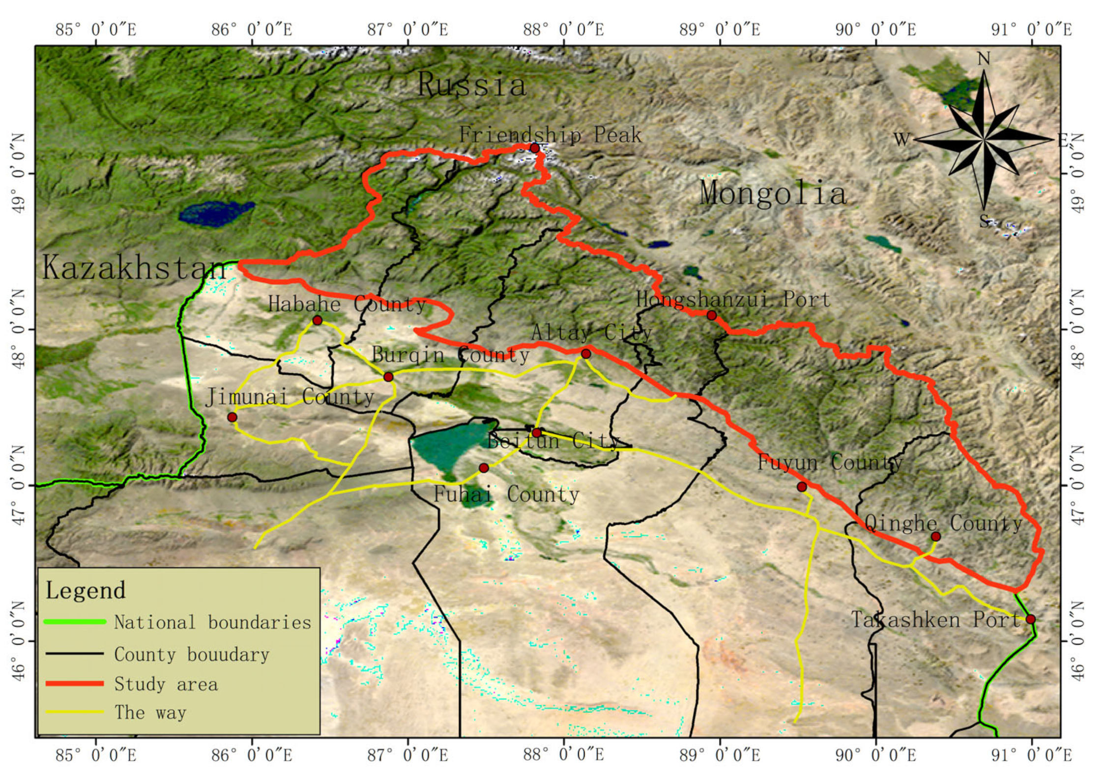
2.1. Study Area
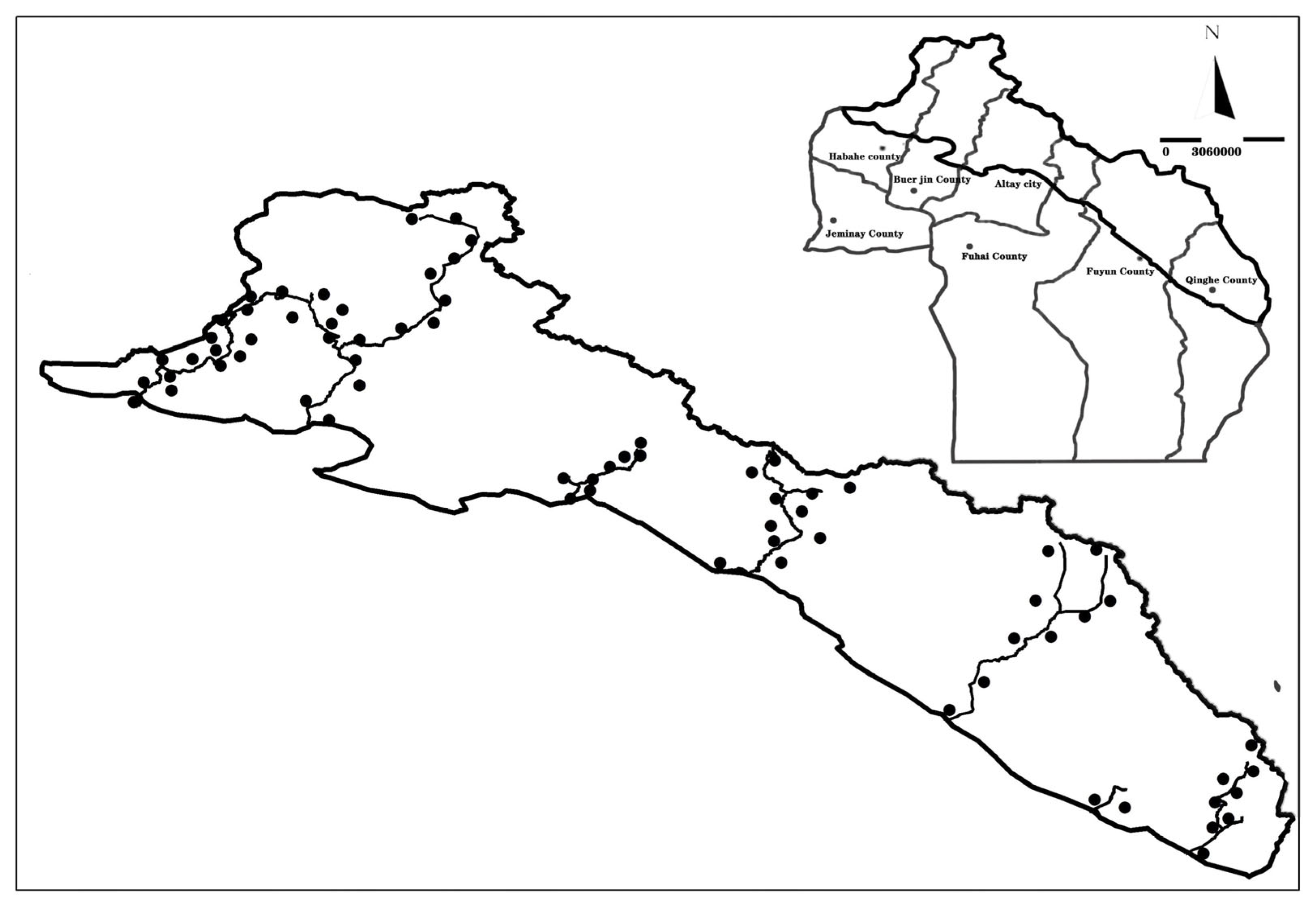
2.2. Survey Methods
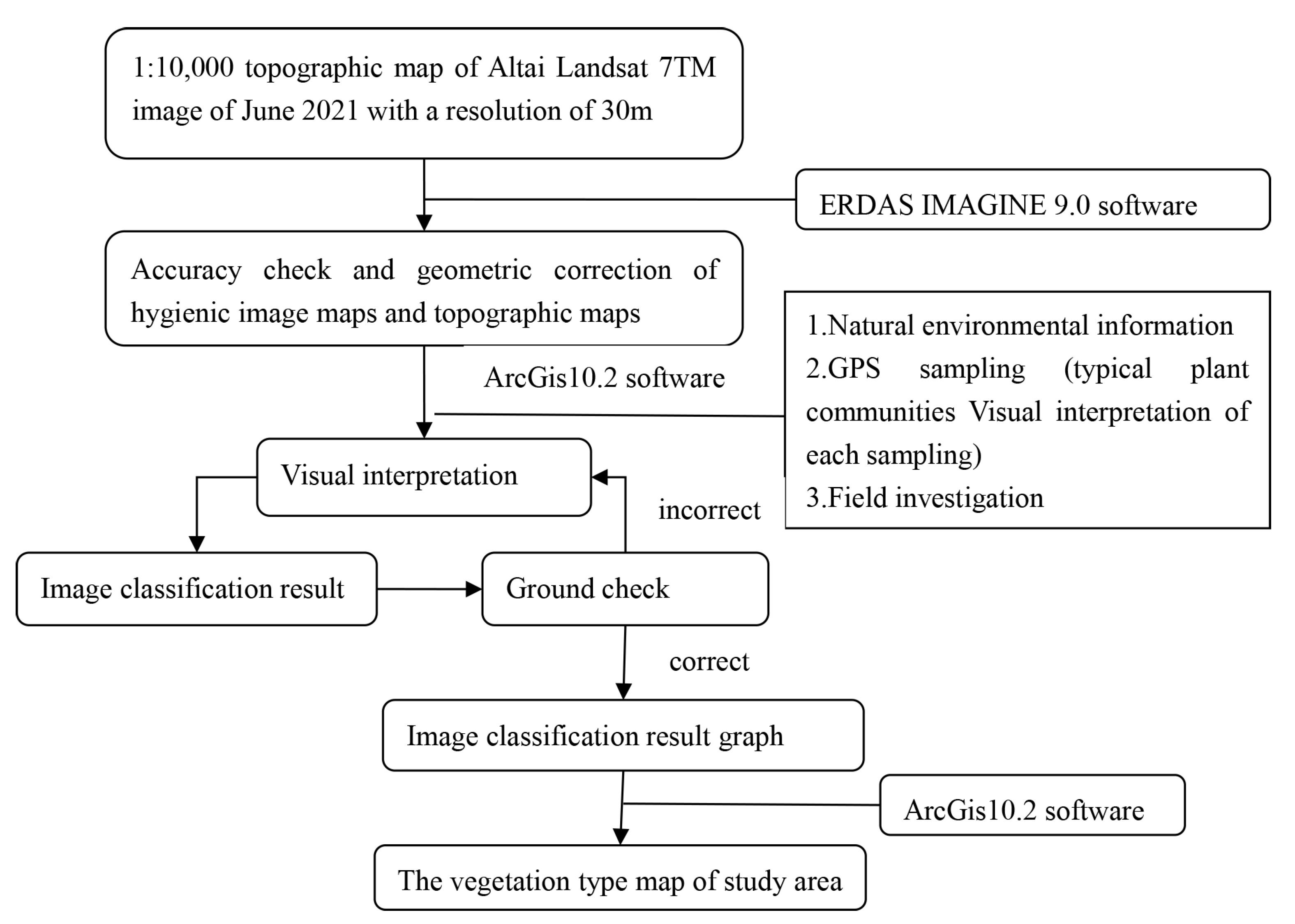
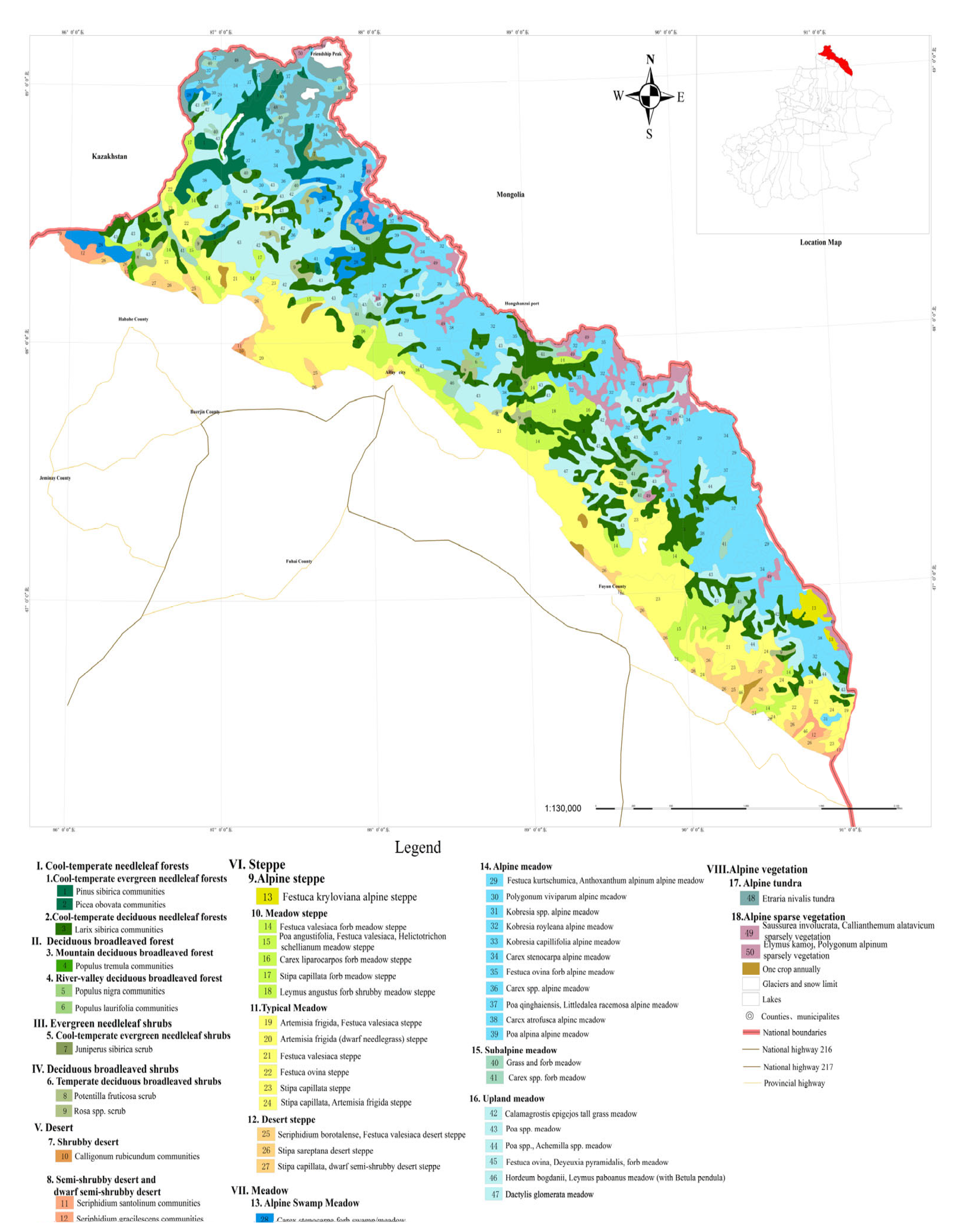
2.3. Vegetation Map Compilation
2.4. Data Processing
3. Results
3.1. The Floral Diversity of the Xinjiang Altai Subrange
3.2. Structural Characteristics of the Main Vegetation Communities Found in the Xinjiang Altai Subrange
4. Discussion
5. Conclusions
Author Contributions
Funding
Data Availability Statement
Acknowledgments
Conflicts of Interest
References
- The Editorial Committee of Vegetation of China. Vegetation of China; Science Press: Beijing, China, 1983. (In Chinese) [Google Scholar]
- Kolbek, J.; Šrůtek, M.; Box, E.O. Forest Vegetation of Northeast Asia; Springer Science + Business Media: New York, NY, USA, 2003; pp. 409–423. [Google Scholar]
- Groves, C.R.; Game, E.T.; Anderson, M.G.; Cross, M.; Enquist, C.; Ferdana, Z.; Girvetz, E.; Gondor, A.; Hall, K.R.; Higgins, J.; et al. Incorporating climate change into systematic conservation planning. Biodivers. Conserv. 2012, 21, 1651–1671. [Google Scholar] [CrossRef]
- Song, Y.C. Recognition and proposal on the vegetation classification system of China. Chin. J. Plant Ecol. 2011, 35, 882–892. [Google Scholar] [CrossRef]
- Cantu, C.; Wright, R.G.; Scott, J.M.; Strand, E. Assessment of current and proposed nature reserves of Mexico based on their capacity to protect geophysical features and biodiversity. Biol. Conserv. 2004, 115, 411–417. [Google Scholar] [CrossRef]
- Guo, Z.L.; Li, Z.; Cui, G.F. Effectiveness of national nature reserve network in representing natural vegetation in mainland China. Biodivers. Conserv. 2015, 24, 2735–2750. [Google Scholar] [CrossRef]
- Qian, Y.B.; Zhang, H.Y.; Wu, Z.N.; Wang, Z.C. Vegetation composition and distribution on the northern slope of Karlik mountain to Naomaohu basin, east Tianshan mountains. J. Arid Land 2011, 3, 15–24. [Google Scholar]
- Beket, U.; Knapp, H.D. Nature conservation and cultural heritage in the Mongolia Altai. Biodivers. Res. Mong. 2012, 16, 25–29. [Google Scholar]
- Cermak, J.; Opgenoorth, L.; Miehe, G. Isolated Mountain Forests in Central Asian Deserts: A Case Study from the Govi Altay, Mongolia; Springer: Berlin/Heidelberg, Germany, 2005; pp. 253–273. [Google Scholar]
- Makunina, N.I. Botanical and geographical characteristics of forest steppe of the Altai-Sayan mountain region. Contemp. Probl. Ecol. 2016, 9, 342–348. [Google Scholar] [CrossRef]
- Olonova, M.V.; Zhang, D.Y.; Duan, S.M.; Yin, L.K.; Pan, B.R. Rare and endangered plant species of the Chinese Altai Mountains. J. Arid Land 2010, 2, 222–230. [Google Scholar]
- Chen, W.L.; Yang, C.Y. A floristic study on the seed plant in Mts. Altai China. Acta Bot. Yunnanica 2000, 22, 371–378. [Google Scholar]
- Pan, X.L. Floristic analysis of seed plant genera in Xinjiang. Bull. Bot. Res. 1999, 19, 249–258. [Google Scholar]
- Chen, X.Y.; Yan, S. A vegetational survey of valley forests in the pediment plant of Altai district of Xinjiang. Acta Phytoecol. Et Geobot. Sin. 1989, 13, 66–72. [Google Scholar]
- Yang, Z.P.; Zhang, X.L. Scientific Research on the Kanas Natural Heritage; Science Press: Beijing, China, 1988. (In Chinese) [Google Scholar]
- Yuan, G.Y. Regional differences and economic significance of vertical natural belts in mountainous regions of Xinjiang. Environ. Prot. Xinjiang 1993, 15, 14–17. [Google Scholar]
- Liao, C.; Morreale, S.J.; Kassam, K.A.S.; Sullivan, P.J.; Fei, D. Following the Green: Coupled pastoral migration and vegetation dynamics in the Altay and Tianshan Mountains of Xinjiang, China. Appl. Geogr. 2014, 46, 61–70. [Google Scholar] [CrossRef]
- Shayila, S.; Jiao, S.Y. The measures of grassland ecological protection and construction in Aletai region, Xinjiang. Pratacultural Sci. 2008, 25, 46–50. [Google Scholar]
- Yao, F.L.; Wang, X.C.H.; Wang, X.T.; Yang, H.J. Study on the surface pollen of western Altay Mountains, China. Ecol. Sci. 2023, 42, 213–222. [Google Scholar]
- Zhang, D.L. Variation characteristics of sporopollen type diversity in arid Central Asia under the Holocene westerly mode: A case study of the Altai Mountains. Arid Zone Res. 2021, 39, 667–675. [Google Scholar]
- Li, Y.Y.; Zhang, Y.; Kong, Z.C.; Yang, Z.J. Surface sporopollen and modern vegetation in Hongshanzui area, Altai, Xinjiang, China. Acta Phytoecol. Sin. 2021, 45, 174–186. [Google Scholar] [CrossRef]
- Xue, R.H.; Jiao, L.; Liu, X.P.; Chen, K. Evaluation of the stability of the radial growth of Larix sibirica at different altitudes in response to climate changein Altai Mountains, Xinjiang. Chin. J. Ecol. 2021, 40, 1275–1284. [Google Scholar]
- Kang, J.; Jiang, S.W.; Huang, J.G. Radial growth response of four dominant tree species to climate factors in the Sayan Range of the Altai Mountains, Russia. Acta Ecol. Sin. 2020, 40, 6135–6146. [Google Scholar]
- Yeernaer, H.; Xu, X.; Dilinuer, T.; Li, H. Response of Vegetation Coverage to Climate Change in Altai Mountain Forest and Grassland Ecological Function Area in Xinjiang, China. J. Ecol. Rural Environ. 2019, 35, 307–315. [Google Scholar]
- Xinjiang Altay Mountain Forestry Bureau. Two-Riversource Comprehensive Scientific Investigation of the Altay Mountains in Xinjiang; Xinjiang Science and Technology Press: Urumqi, China, 2004. (In Chinese) [Google Scholar]
- Feng, M.; Ren, M.L. Scientific Investigation of Hanasse in Xinjiang; Science Press: Beijing, China, 1990. (In Chinese) [Google Scholar]
- Feng, Y.; Zhang, Y.; Wang, X. Comparison on composition and flora of shrubs between north and south of Xinjiang. J. Plant Resour. Environ. 2014, 23, 94–99. [Google Scholar]
- Chytrý, M.; Danihelka, J.; Kubešová, S.; Lustyk, P.; Ermakov, N.; Hájek, M.; Hájková, P.; Kočí, M.; Otýpková, Z.; Roleček, J.; et al. Diversity of forest vegetation across a strong gradient of climatic continentality: Western Sayan Mountains, southern Siberia. Plant Ecol. 2008, 196, 61–83. [Google Scholar] [CrossRef]
- Krestov, P.V.; Ermakov, N.B.; Osipov, S.V.; Nakamura, Y. Classification and phytogeography of Larch forests of northeast Asia. Folia Geobot. 2009, 44, 323–363. [Google Scholar] [CrossRef]
- Song, Y.C. Ecology of Vegetation; East China Normal University Press: Shanghai, China, 2001. [Google Scholar]
- Yao, J. The Study of RS&GIS-Based Forest Landscape Classification and Distribution Pattern in the Three Gorges Reservoir Area. Master’s Thesis, Huazhong Agricultural University, Wuhan, China, 2008. [Google Scholar]
- Jing, X.H. Study on Landscape Pattern of Vegetation and Spatial Variation of Biodiversitv in the Irtvsh River Basin, Xinjiang. Ph.D. Thesis, Chinese Academy of Forestry Sciences, Beijing, China, 2008. [Google Scholar]
- Xinjiang Complex Expert Team of the Chinese Academy of Sciences. The Vegetation and Its Utilization in Xinjiang; Science Press: Beijing, China, 1978. (In Chinese) [Google Scholar]
- Wang, W.; Pei, H.; Wang, X. A logistic analysis on vegetation classification system based on dominant species with an illustrational scheme. Biodivers. Sci. 2016, 24, 136–147. [Google Scholar] [CrossRef]
- Chytrý, M.; Ermakov, N.; Danihelka, J.; Hajek, M.; Hájková, P.; Horsák, M.; Kočí, M.; Kubešová, S.; Lustyk, P.; Otýpková, Z.; et al. High species richness in hemiboreal forests of the northern Russian Altai, southern Siberia. J. Veg. Sci. 2012, 23, 605–616. [Google Scholar] [CrossRef]
- Walter, H. Vegetation of the Earth and Ecological Systems of the Geo-Biosphere, 2nd ed.; Springer: New York, NY, USA, 1979. [Google Scholar]
- Zhang, X.S. Vegetation Map of China and Its Geographic Pattern; Geological Publishing: Beijing, China, 2007. (In Chinese) [Google Scholar]
- Feng, Z.; Sun, A.; Abdusalih, N.; Ran, M.; Kurban, A.; Lan, B.; Zhang, D.; Yang, Y. Vegetation changes and associated climatic changes in the southern Altai Mountains within China during the Holocene. Holocene 2016, 27, 683–693. [Google Scholar] [CrossRef]
- Schlütz, F.; Dulamsuren, C.; Wieckowska, M.; Mühlenberg, M.; Hauck, M. Late Holocene vegetation history suggests natural origin of steppes in the northern Mongolian mountain taiga. Palaeogeogr. Palaeoclimatol. Palaeoecol. 2008, 261, 203–217. [Google Scholar] [CrossRef]
- Rudaya, N.; Tarasov, P. Mechanisms driving the Holocene vegetation and climate dynamics in central Asia: Case study—The Altai Mountains. In Proceedings of the Egu General Assembly Conference, Vienna, Austria, 19–24 April 2009. [Google Scholar]
- Tchebakova, N.M.; Blyakharchuk, T.A.; Parfenova, E.I. Reconstruction and prediction of climate and vegetation change in the Holocene in the Altai–Sayan mountains, Central Asia. Environ. Res. Lett. 2009, 4, 045025. [Google Scholar] [CrossRef]
- Liu, B. Vertical patterns in plant diversity and their relations with environmental factors on the southern slope of the Tianshan Mountains (middle section) in Xinjiang (China). J. Mt. Sci. 2017, 14, 742–757. [Google Scholar] [CrossRef]
- Quintana, C.; Girardello, M.; Barfod, A.S.; Balslev, H. Diversity patterns, environmental drivers and changes in vegetation composition in dry inter-Andean valleys. J. Plant Ecol. 2017, 10, 461–475. [Google Scholar] [CrossRef]
- German, D.; Neuffer, B.; Friesen, N.; Hurka, H. Contribution to the knowledge of the Flora of the Mongolian Altai II. Feddes Repert. 2003, 114, 632–637. [Google Scholar] [CrossRef]
- Ermakov, N.; Morozova, O. Syntaxonomical survey of boreal oligotrophic pine forests in northern Europe and Western Siberia. Appl. Veg. Sci. 2011, 14, 524–536. [Google Scholar] [CrossRef]
- Neuffer, B.; Oyuntseg, B.; Schamsran, Z. Contribution to the knowledge of the Flora of the Mongolian Altai. Feddes Repert. 2003, 114, 358–371. [Google Scholar] [CrossRef]
- Polyakova, M.A.; Dembicz, I.; Becker, T.; Becker, U.; Demina, O.N.; Ermakov, N.; Filibeck, G.; Guarino, R.; Janišová, M.; Jaunatre, R.; et al. Scale- and taxon-dependent patterns of plant diversity in steppes of Khakassia, South Siberia (Russia). Biodivers. Conserv. 2016, 25, 2251–2273. [Google Scholar] [CrossRef]
- Beket, U. The Vegetation of Mongolia Altai. Problems of Sustainable Land Use and Nature Conservation; BfN-Skripten: Boon, Germany, 2009; pp. 267–315. [Google Scholar]


| Vegetation Type | Vegetation Subtype | Formation/Community | Proportion of Total Area (%) |
|---|---|---|---|
| I. Cold-temperate needleleaf forests | 1. Cool-temperate evergreen needleleaf forests | (1) Pinus sibirica communities | 15.89 |
| (2) Picea obovata communities | |||
| 2. Cool-temperate deciduous needleleaf forests | (3) Larix sibirica communities | ||
| II. Deciduous broadleaved forest | 3. Mountain deciduous broadleaved forest | (4) Populus tremula communities | 0.30 |
| 4. River-valley deciduous broadleaved forest | (5) Populus nigra communities | ||
| (6) Populus laurifolia communities | |||
| III. Evergreen needleleaf shrubs | 5. Cool-temperate evergreen needleleaf shrubs | (7) Juniperus sibirica scrub | 0.11 |
| IV. Deciduous broadleaved shrubs | 6. Temperate deciduous broadleaved shrubs | (8) Potentilla fruticosa scrub | 1.15 |
| (9) Rosa spp. scrub | |||
| V. Desert | 7. Shrubby desert | (10) Calligonum rubicundum communities | 0.81 |
| 8. Semi-shrubby desert and dwarf semi-shrubby desert | (11) Seriphidium santolinum communities | ||
| (12) Seriphidium gracilescens communities | |||
| VI. Steppe | 6. Alpine steppe | (13) Festuca kryloviana alpine steppe | 30.56 |
| 10. Meadow steppe | (14) Festuca valesiacavarii forb meadow steppe | ||
| (15) Poa angustifolia, Festuca valesiaca, Helictotrichchon schellianum meadow steppe | |||
| (16) Carex liparocarpos forb meadow steppe | |||
| (17) Stipa capillata forb meadow steppe | |||
| (18) Leymus angustus forb shrubby meadow steppe | |||
| 11. Typical Meadow | (19) Artemisia frigida, Festuca valesiaca steppe | ||
| (20) Artemisia frigida (dwarf needlegrass) steppe | |||
| (21) Festuca valesiaca steppe | |||
| (22) Festuca ovina steppe | |||
| (23) Stipa capillata steppe | |||
| (24) Stipa capillata, Artemisia frigida steppe | |||
| 12. Desert steppe | (25) Seriphidium borotalense, Festuca valesiaca desert steppe | ||
| (26) Stipa sareptana desert steppe | |||
| (27) Stipa capillata dwarf semi-shrubby desert steppe | |||
| VII. Meadow | 13. Alpine Swamp Meadow | (28) Carex stenocarpa forb swamp/meadow | 44.24 |
| 14. Alpine meadow | (29) Festuca kurtschumica, Anthoxanthum alpinum alpine meadow | ||
| (30) Polygonum viviparum alpine meadow | |||
| (31) Kobresia spp. alpine meadow | |||
| (32) Kobresia royleana alpine meadow | |||
| (33) Kobresia capillifolia alpine meadow | |||
| (34) Carex stenocarpa alpine meadow | |||
| (35) Festuca ovina forb alpine meadow | |||
| (36) Carex spp. alpine meadow | |||
| (37) Poa qinghaiensis, Littledalea racemosa alpine meadow | |||
| (38) Carex atrofusca alpine meadow | |||
| (39) Poa alpina alpine meadow | |||
| 15. Subalpine meadow | (40) Festuca spp., forb meadow | ||
| (41) Carex spp., forb meadow | |||
| 16. Upland meadow | (42) Calamagrostis epigeios tall grass meadow | ||
| (43) Stipa spp. meadow | |||
| (44) Stipa spp., Achemilla spp. meadow | |||
| (45) Festuca ovina, Deyeuxia pyramidalis forb meadow | |||
| (46) Hordeum bogdanii, Leymus paboanus meadow (with Betula pendula) | |||
| (47) Dacylis glomerata meadow | |||
| VIII. Alpine vegetation | 17. Alpine tundra | (48) Etraria nivalis tundra | 6.53 |
| 18. Alpine sparse vegetation | (49) Saussurea involucrata, Callianthemum alatavicum sparsely vegetated community | ||
| (50) Elymus kamoji, Polygonum alpinum sparsely vegetated community |
| Formation/Community | Distribution Regions | Altitude (m) | Soil Type | Distribution Area | Main Representative | Population Density (%) | Community Height (m) | Canopy Closure |
|---|---|---|---|---|---|---|---|---|
| (1) Pinus sibirica communities | In the upper reaches of Kanas Lake and the Homer River | 1600–1900 | Mountain gray forest soil | 0.58 | Tree layers: Pinus sibirica Du Tour, Picea obovata Ledeb., Larix sibirica Ledeb.; shrub layer: Lonicera caerulea var. altaica Pall., Juniperus sibirica Burgsd., Vaccinium myrtillus L; herbaceous layer: Caltha palustris L., Pyrola spp., Moneses uniflora (Linn.) A. Gray, and Luzula pallescens (Whlb.) Sw.; the moss layer: was widely developed, covering more than 25% of the area, and the main moss present was Dicranum spurium Hedw. | 70 | 15.00–25.00 | 0.70–0.80 |
| (2) Picea obovata communities | Distributed along low-elevation valley margins or in the moist valley terraces of the forest steppe | 1300–2100 | Peat mire or dark gray forest soil | 2.37 | Tree layers: Picea obovata Ledeb., Larix sibirica Ledeb., Betula pendula Roth.; shrub layer: Rosa acicularis Lindl. RoL Monr., Ribes nigrum L.; herbaceous layer: Pyrola spp., Corallorhiza trifida Chatel, and Adoxa moschatellina L.; the moss layer: were widespread, covering 75–85% of the area. Brachythecium albicans (Hedw.) B. S. G. and Hylocomium splendens (Hedw.) B. S. G., were the most common. | 80 | 14.00–20.00 | 0.6 |
| (3) Larix sibirica communities | Widely distributed on the shaded and half-shaded slopes along the central and southeastern parts of the Xinjiang Altai subrange | west: 1300–2300; southeastern: 1700–2600 m | Mountain gray forest soil, and turfgrass predominated the soil was highly strengthened | 13.01 | Tree layers: Larix sibirica Ledeb., Picea obovata Ledeb., Pinus sibirica Du Tour, Betula pendula Roth., Populus tremula L., Sorbus sibirica Hedl., shrub layer: Cotoneaster spp., Lonicera spp., Spiraea spp., Betula rotundifolia Spach; Herbaceous layer: Kobresia spp., Dactylis glomerata L., Deyeuxia pyramidalis (Host) Veldkamp, Eragrostis pilosa (L.) Beauv.; The distribution of mosses in the forest was limited. | 80 | 15.00–17.00 | 0.70–0.90 |
| (4) Populus tremula communities | On the slopes of valleys and lakeside terraces or the edge of patches of the Larix sibirica formation. | 1500 | Brown coniferous soil | 0.07 | Tree layers: Populus tremula L., Betula pendula Roth., Larix sibirica Ledeb., Picea obovata Ledeb.; shrub layer: Cotoneaster spp., Spiraea spp., Lonicera caerulea var. altaica Pall.; Herbaceous layer: Calamagrostis epigeios (Linn.) Roth, Elymus repens Desv., Dactylis glomerata L., Geranium pseudosibiricum J.; Moss was occasionally also seen in this formation. | 60 | 15.00–25.00 | 0.30–0.50 |
| (5) Populus nigra communities | Along the banks of the Irtysh River in the south of the Altai Mountains | 600 | Brown forest soil | 0.10 | Tree layers: Populus nigra L., Populus alba, Populus × jrtyschensis, Populus alba L., shrub layer: Rosa acicularis Lindl. and different willow shrubs (Salix pentandra L., Salix triandra L., Salix turanica Nas.); Herbaceous layer: Poa nemoralis L., Aquilegia glandulosa Fisch. ex Link., Geum aleppicum Jacq. | 60–70 | 10.00–15.00 | 0.2 |
| (6) Populus laurifolia communities | Low-altitude plains in the Xinjiang Altai subrange | 600–900 | Brown calcium-rich soil | 0.14 | Tree layers: Populus laurifolia Ledeb., Populus alba L., Betula pendula Roth.; shrub layer: Rosa acicularis Lindl., Ribes pulchellum Turcz., Cotoneaster oliganthus Pojark.; Herbaceous layer: Phragmites australis (Cav.) Trin., Juncus spp., Elytrigia repens (L.) Nevski | 60–75 | 10.00–12.00 | 0.20–0.40 |
| (7) Juniperus sibirica scrub | In the middle of shady slopes | 1400–1600 | Rocky shrubby-meadow soil | 0.11 | Shrub layer: Juniperus communis var. saxatilis Pall., Cotoneaster uniflorus Bge., Lonicera hispida Pall. ex Roem. et Schult, Rosa acicularis Lindl.; Herbaceous layer: Iris ruthenica Ker-Gawl., Phlomis oreophila Kar., Poa pratensis L. | 50–60 | 0.50–1.00 | |
| (8) Dasiphora fruticosa scrub | On sunny slopes southwest of the Altai Mountains | 2400–2600 | Alpine shrub meadow soil | 0.21 | Shrub layer: Dasiphora fruticosa (L.) Rydb., Salix sclerophylla Anderss., Spiraea alpina Pall., Dasiphora parvifolia (Fisch. ex Lehm.) Juz.; Herbaceous layer: Stipa purpurea Griseb., Dracocephalum heterophyllum Benth., Carex atrofusca Schkuhr., etc. | 50–65 | 0.50–1.00 | |
| (9) Rosa spp. scrub | On the northern slope of mountains | 1300–1800 | Mountain chernozem | 0.94 | This community type is also one of the most typical communities in temperate deciduous shrubland. shrub layer: Rosa spinosissima Linn., Rosa acicularis Lindl., Rosa platyacantha Schrenk, Rosa laxa Retz., Spiraea hypericifolia L., Cotoneaster melanocarpus Lodd. and various Ribes spp.; Herbaceous layer: Calamagrostis epigeios (Linn.) Roth, Geum aleppicum Jacq., Achillea millefolium Linn. | 70 | 1.50–2.00 | |
| (10) Calligonum rubicundum communities | Narrowly distributed along the south bank of the Irtysh River | 600 | Sand or gravel soil | 0.03 | This formation is usually constituted a sparse mono-dominant community of Calligonum rubicundum Bunge, and it included few companion species. shrub layer: Astragalus gebleri Fisch. ex Bong., Atraphaxis frutescens (L.) Eversm., Kochia prostrata (L.) Schrad.; Herbaceous layer: Corispermum lehmannianum Bunge, Stipa caucasica subsp. glareosa (P. A. Smirn.) Tzvelev | >10% | 1.00–1.50 | |
| (11) Seriphidium santolinum communities | In sandy areas in the riparian terrace of the Irtysh and Ulungur rivers | 600–700 | Sandy soil | 0.05 | The species composition of the community was simple and often included many grasses. Herbaceous layer: Seriphidium santolinum (Schrenk) Poljak., Bassia prostrata (L.) Beck, Corispermum lehmannianum Bunge, Eremopyrum triticeum (Gaertn.) Nevski | 20–30 | 0.20–0.30 | |
| (12) Seriphidium gracilescens communities | It was rare and found only in mountain alluvial fan or mountain plain areas in mountain alluvial fan or mountain plain areas | 600–900 | Gravel and calcareous soil | 0.72 | The community structure was relatively simple. Herbaceous layer: Seriphidium gracilescens (Krasch. et Iljin) Poljak., Nanophyton erinaceum (Pall.) Bge.), Artemisia frigida Willd., Atraphaxis decipiens Jaub. et Spach | 10–18 | 0.15–0.30 | |
| (13) Festuca kryloviana alpine steppe | In the subalpine zone in the eastern central Altai Mountains | 2200–2600 | Subalpine meadow soil | 0.57 | Herbaceous layer: Festuca kryloviana Reverd., Draba nemorosa L., Bistorta officinalis Raf., Festuca kurtschumica E. Alexeev | 85 | 0.20–0.25 | |
| (14) Festuca valesiacavarii forb meadow steppe | Distributed below the forest belt | 1200–1800 | Mountain chestnut soil | 3.08 | This community type was typical of mountain meadow grasslands found in the Xinjiang Altai subrange. Herbaceous layer: Festuca valesiaca subsp. sulcata (Hackel) Schinz et R. Keller, Heteropappus altaicus (Willd.) Novopokr., Dracocephalum nutans Linn. and Gagea fedtschenkoana Pasch. | 50 | 0.20–0.50 | |
| (15) Poa angustifolia, Festuca valesiaca, Helictotrichchon schellianum meadow steppe | In the frontal mountain belt and mid-mountain zone of the Xinjiang Altai subrange | 1200–1800 | Chestnut soil and chernozem | 1.18 | Herbaceous layer: Poa pratensis subsp. angustifolia (L.) Lejeun., Festuca valesiaca subsp. sulcata (Hackel) Schinz et R. Keller, Avenula pubescens (Huds.) Dumort., Phleum phleoides (L.) Karst., Geum rivale L., Thalictrum minus L. | 60–70 | 0.20–0.60 | |
| (16) Carex liparocarpos forb meadow steppe | On sunny and half sunny slopes | 1200–1800 | Chestnut soil | 2.00 | Herbaceous layer: Carex liparocarpos Gaudin, Myosotis suaveolens Waldst. et Kit., Campanula albertii Trautv., Aster altaicus Willd. | 40–55 | 0.15–0.30 | |
| (17) Stipa capillata forb meadow steppe | In mountain valleys | 1400–1800 | Mountain chernozem soil | 0.32 | This community type was dominant in the mountainous steppe of the Xinjiang Altai subrange. Herbaceous layer: Stipa capillata L., Alopecurus pratensis L., Phlomoides oreophila (Kar. & Kir.) Adylov, Kamelin & Makhm., Pulsatilla patens (L.) Mill., Anemone sylvestris L. | 50–70 | 0.30–0.50 | |
| (18) Leymus angustus forb shrubby meadow steppe | On rocky and sunny mountain slopes near coniferous forests and grassland shrubs | 1400–2000 | Rocky mountain chernozem soil | 0.52 | This community was often present as invasive shrubs, and the plant cover of the shrub layer ranged from 15 to 20%. shrub layer: Spiraea hypericifolia L., Cotoneaster uniflorus Bge., Rosa spinosissima L.; Herbaceous layer: Leymus angustus (Trin.) Pilger, Phleum pratense L., Poa pratensis subsp. angustifolia (Linnaeus Lejeun, Helictotrichon hookeri (Scribn.), Galium spurium L., Androsace septentrionalis L., Achillea millefolium L. | 40–60 | 0.15–0.20 | |
| (19) Artemisia frigida, Festuca valesiaca steppe | In the mid-mountain zones | 1400–1700 | Mountain chestnut soil | 0.41 | Shrub layer: Spiraea hypericifolia L., Lonicera caerulea L., Rosa spinosissima L.; Herbaceous layer: Artemisia frigida Willd., Festuca valesiaca Schleich. ex Gaudin, Koeleria spp., Stipa capillata L., Phleum pratense L. | 25–35 | 0.30–0.60 | |
| (20) Artemisia frigida (dwarf needlegrass) steppe | In the Altai steppe zone | 1300–2000 | Mountain chestnut soil | Herbaceous layer: Artemisia frigida Willd., Carex liparocarpos Gaudin, Oxytropis spp. and Galium verum L. | 30 | 0.20–0.30 | ||
| (21) Festuca valesiaca steppe | The most widely distributed type of steppe in the Xinjiang Altai subrange, appeared on sunny types | 1100–1300 | Mountain chestnut soil | 13.60 | Herbaceous layer: Festuca valesiaca Schleich ex Gaud, Carex spp., Artemisia frigida Willd., Oxytropis spp., Scorzonera spp., Leontopodium spp. | 50–60 | 0.10–0.30 | |
| (22) Festuca ovina steppe | In the forest-steppes | 1200–1800 | Brown calcium-rich soil | 1.45 | Herbaceous layer: Festuca ovina L., Artemisia frigida Willd., Psathyrostachys juncea (Fisch.) Nevski, Sedum hybridum L., Astragalus spp., Patrinia intermedia (Horn.) Roem. | 50–65 | 0.15–0.25 | |
| (23) Stipa capillata steppe | The most common mountainous steppe in the Altai mountains, and is found on all (shady, semi-shady, and sunny) slopes in the mid-mountain zone | 600–1100 | Mountain chestnut soil | 2.75 | Shrub layer: Spiraea hypericifolia L.; Herbaceous layer: Stipa capillata L., Artemisia frigida Willd., Carex liparocarpos Gaudin, Agropyron cristatum P. Beauv. | 60 | 0.20–0.40 | |
| (24) Stipa capillata, Artemisia frigida steppe | In shady and semi-shady slopes in the Xinjiang Altai subrange | 1500–1700 | Mountain chestnut soil | 1.21 | Herbaceous layer: Stipa capillata L., Artemisia frigida Willd., Agropyron cristatum P. Beauv., Ephedra intermedia Schrenk, Elymus kamoji (Ohwi) S. L. Chen. | 50–60 | 0.10–0.30 | |
| (25) Seriphidium borotalense, Festuca valesiaca desert steppe | In the mountainous alluvial fan of the western end of the Xinjiang Altai subrange | 1000–1500 | Brown calcium-rich soil | 0.73 | In this community type, Seriphidium borotalense was the structural species and Festuca valesiaca was the main companion species. Herbaceous layer: Koeleria spp., Atraphaxis frutescens (L.) Eversm., Astragalus arbuscula Pall. | 30 | 0.10–0.30 | |
| (26) Stipa sareptana desert steppe | On hillsides and south-facing mountain fronts in the south of the Altai Mountains | 1000–1300 | Brown calcium-rich soil | 2.26 | Herbaceous layer: Stipa sareptana Becher, Koeleria spp., Leymus ovatus (Trin.) Tzvel., Allium polyrhizum Turcz. ex Regel. | 30–50 | 0.10–0.35 | |
| (27) Stipa capillata dwarf semi-shrubby desert steppe | In the lower mountain steppe in the southern Xinjiang Altai subrange | 1000–1300 | Brown calcium-rich soil | 0.23 | The structural layer of these communities was chiefly needlegrass, and the companion species included many small shrubs. shrub layer: Caragana leucophloea Pojark., Nanophyton erinaceum (Pall.) Bunge, Herbaceous layer: Stipa capillata L., Stipa sareptana Becher | 35–45 | 0.40–0.60 | |
| (28) Carex stenocarpa forb swamp/meadow | along shady slopes or glacier-formed valleys in the northwestern Xinjiang Altai subrange. | 1500–2000 | Deep alpine meadow soil | 2.01 | Herbaceous layer: Carex stenocarpa Turcz. ex V. Krecz., Poa pratensis subsp. angustifolia (L.) Lejeun., Geranium rectum Trautv., Carex atrofusca subsp. minor (Boott) T. Koyama, Gentiana algida Pall., Phleum phleoides (Linn.) Karst. | 55–65 | 0.2–0.6 | |
| (29) Festuca kurtschumica, Anthoxanthum alpinum alpine meadow | On gentle hillsides or watersheds of alpine zones in the southern Xinjiang Altai subrange | 2400–2600 | Hypertrophic alpine meadow soils | 3.68 | Herbaceous layer: Festuca kurtschumica E. Alexeev, Anthoxanthum alpinum á. Love et D. Love, Ranunculus altaicus Laxm., Viola altaica Ker-Gawl., Silene graminifolia Otth, Phleum phleoides (Linn.) Karst. | 60–85 | 0.10–0.30 | |
| (30) Polygonum viviparum alpine meadow | In glacial valleys and valley lowlands in the western Xinjiang Altai subrange | 2400–2600 | Deep alpine meadow soil | 0.72 | Herbaceous layer: Polygonum viviparum L., Oreomecon nudicaulis (L.) Banfi, Bartolucci, J.-M. Tison & Galasso, Anemone sylvestris L., Phlomis pratensis Kar. et Kir., Phlomoides pratensis (Kar. & Kir.) Adylov, Kamelin & Makhm., Carex atrofusca subsp. minor (Boott) T. Koyama | 80% | 0.10–0.30 | |
| (31) Kobresia spp. alpine meadow | Only in the alpine belt in the southeast Xinjiang Altai subrange. | 2500 | Alpine meadow soil | 4.09 | Herbaceous layer: Kobresia myosuroides (Villars) Foiri, Kobresia royleana (Nees) Bocklr., Anthoxanthum odoratum L., Androsace filiformis Retz., Carex onoei Franch. et Savat., Potentilla chinensis Ser. | 50–65% | 0.10–0.20 | |
| (32) Kobresia royleana alpine meadow | In alpine meadow soil on shady slopes in the alpine and subalpine belts in the central portion of the Xinjiang Altai subrange | 2400–27,000 | Alpine meadow soil | 4.11 | Herbaceous layer: Kobresia royleana (Nees) Bocklr., Myosotis alpestris F. W. Schmidt, Primula nivalis Pall., Phleum phleoides (Linn.) Karst. | 60–75 | 0.10–0.15 | |
| (33) Kobresia capillifolia alpine meadow | Only in a small area in the northwest corner of the alpine zone of the Xinjiang Altai subrange | 2600 | Alpine meadow soil | 0.09 | Herbaceous layer: Kobresia capillifolia (Decne.) C. B. Clarke, Cardamine parviflora L., Carex stenocarpa Turcz. ex V. Krecz., Saussurea alpina (Linn.) DC. | 60–75 | 0.10–0.15 | |
| (34) Carex stenocarpa alpine meadow | In shady slopes and glacial valleys in the northern and southeastern Xinjiang Altai subrange. | 2300–2600 | Alpine meadow soil | 5.99 | Herbaceous layer: Carex stenocarpa Turcz. ex V. Krecz., Bistorta vivipara (L.) Gray, Anthoxanthum odoratum Linn., Saxifraga hirculus L., Koenigia alpina (All.) T. M. Schust. & Reveal, Carex rhynchophysa Fisch., C.A.Mey. & Avé-Lall. | 55–70 | 0.10–0.25 | |
| (35) Festuca ovina forb alpine meadow | In alpine and sub-alpine zones in the middle and south-central Xinjiang Altai subrange | 2100–2700 | Alpine meadow soil | 2.37 | Herbaceous layer: Festuca ovina L., Festuca rubra L., Festuca kurtschumica E. Alexeev, Draba alpina L., Gentiana algida Pall. | 40–50 | 0.10–0.30 | |
| (36) Carex spp. alpine meadow | Formed patches in the wet shady slopes or U-shaped valleys | 2400–2600 | Alpine meadow soil | 2.44 | Herbaceous layer: Carex atrofusca subsp. minor (Boott) T. Koyama, Carex dichroa Freyn, Carex turkestanica Rgl., Carex stenocarpa Turcz. ex V. Krecz., Rhodiola quadrifida (Pall.) Fisch. et Mey., Ranunculus altaicus Laxm. | 50–65 | 0.10–0.20 | |
| (37) Poa qinghaiensis, Littledalea racemosa alpine meadow | In alpine gullies and elsewhere in alpine and sub-alpine zones in the north and southeastern parts of the Xinjiang Altai subrange | 2400–2800 | Alpine meadow soil | 3.21 | Herbaceous layer: Poa qinghaiensis Soreng et G. Zhu, Littledalea racemosa Keng, Bistorta vivipara (L.) Gray, Erigeron eriocalyx (Ledeb.) Vierh., Carex atrofusca subsp. minor (Boott) T. Koyama | 45–60 | 0.15–0.30 | |
| (38) Carex atrofusca alpine meadow | In the shady slopes or valleys in the alpina and sub-alpine zones of the Xinjiang Altai subrange | 2500–2800 | Alpine meadow soil | 2.54 | Herbaceous layer: Carex atrofusca subsp. minor (Boott) T. Koyama, Cerastium spp., Geranium albiflorum Ledeb., Pedicularis elata Willd. | 60–70 | 0.1–0.2 | |
| (39) Poa alpina alpine meadow | On sunny slopes or watersheds | 2400–2600 | Alpine meadow soil | 1.55 | Herbaceous layer: Poa alpina L., Kobresia bellardii All., Elytrigia repens Desv., Poa sibirica Trin. | 40 | 0.1–0.3 | |
| (40) Grass and forb meadow | In the northwestern part of the Xinjiang Altai subrange in gentle watersheds or hillsides | 1800–2400 | Subalpine meadow soil | 0.46 | Herbaceous layer: Anthoxanthum odoratum L., Poa alpina L., Festuca rubra L., Campanula albertii Trautv., Gentiana karelinii Griseb., Erigeron eriocalyx (Ledeb.) Vierh., | 60–90 | 0.1–0.3 | |
| (41) Carex spp., forb meadow | Along the slopes of hills and mountains in the Xinjiang Altai subrange | 2200–2400 | Subalpine meadow soil | 1.94 | Herbaceous layer: Carex dichroa Freyn, Carex supina Willd. ex Wahlenb., Poa altaica Trin., Trisetum sibiricum Rupr., Festuca rubra Linn., Primula algida Adam, Ranunculus altaicus Laxm., Viola biflora L. | 60–80 | 0.1–0.4 | |
| (42) Calamagrostis epigeios tall grass meadow | Mainly located in the floodplain and inter-valley regions in the northwest and southeast of the Xinjiang Altai subrange | 1600–1900 | Mountain chernozem | 1.42 | Herbaceous layer: Calamagrostis epigeios (Linn.) Roth, Trifolium lupinaster L., Leymus spp., Elymus spp. | 65–75 | 0.4–1.2 | |
| (43) Poa spp. meadow | Widely distributed throughout the mid-mountain zones of the Xinjiang Altai subrange. | 1200–2100 | Mountain chernozem | 10.31 | Herbaceous layer: Sanguisorba alpina Bge., Poa sibirica Trin., Poa nemoralis L., Poa pratensis subsp. angustifolia (L.) Lejeun., Koenigia alpina (All.) T. M. Schust. & Reveal, Sanguisorba alpina Bge., Phlomoides pratensis (Kar. & Kir.) Adylov, Kamelin & Makhm. | 70–80 | 0.3–0.4 | |
| (44) Poa spp., Achemilla spp. meadow | Along shady slopes in the Liangheyuan Nature Reserve | 1700–2300 | Mountain chernozem | 0.54 | Herbaceous layer: Poa glauca subsp. altaica (Trin.) Olonova et G. Zhu, Anthoxanthum alpinum á. Love et D. Love, Festuca rubra Linn., Carex atrofusca subsp. minor (Boott) T. Koyama, Carex onoei Franch. et Savat., Carex obtusata Liljebl., Alchemilla sibirica Zam., Alchemilla pinguis Juz., Thalictrum minus Linn. | 70 | 0.3–0.5 | |
| (45) Festuca ovina, Deyeuxia pyramidalis forb meadow | Only in the mountain depressions near Lake Kanas | 1200–1600 | Mountain chernozem | 0.08 | Herbaceous layer: Festuca ovina L., Deyeuxia pyramidalis (Host) Veldkamp, Bistorta vivipara (L.) Gray, Carex duriuscula subsp. rigescens (Franch.) S. Y. Liang et Y. C. Tang, Festuca rubra L. | 55–65 | 0.3–0.5 | |
| (46) Hordeum bogdanii, Leymus paboanus meadow (with Betula pendula) | Only two areas: in a small area in the low valley in the Qinghe area in the eastern part of the Xinjiang Altai subrange, and in the valley of the Qingli River | 1200–1400 | Mountain chernozem | 0.17 | Shrub layer: Betula pendula Roth., Salix pentandra L., Salix triandra L., Herbaceous layer: Elymus spp., Leymus paboanus (Claus) Pilger, Calamagrostis epigeios (Linn.) Roth, Elytrigia repens Desv. | 80–90 | 0.6–0.9 | |
| (47) Dacylis glomerata meadow | In mountainous areas between Fuhai and Fuyun Counties in the mid-west Xinjiang Altai subrange | 1500–1700 | Fertile mountain meadow soil | 0.80 | Herbaceous layer: Dactylis glomerata L., Bromus inermis Leyss, Geranium pratense L., Sanguisorba alpina Bunge | 80–90 | 0.6–1.3 | |
| (48) Flavocetraria nivalis tundra | Located on gravel hillsides in the Kanas region of the northwestern Xinjiang Altai subrange. | 2600 | Alpine ice marsh soil | 3.06 | Herbaceous layer: Flavocetraria nivalis (L.) Kärnefelt & A. Thell, Flavocetraria cucullata (Bellardi) Kärnefelt & A., Parmelia spp., Potentilla nivea L., Waldheimia tridactylites Kar. et Kir, Gentiana algida Pall. | 5–10 | 0.05–0.1 | |
| (49) Saussurea involucrata, Callianthemum alatavicum sparsely vegetated community | In alpine rock slopes | 3000 | Alpine ice marsh soil | 3.41 | Herbaceous layer: Echeveria laui Moran & J. Meyrán, Callianthemum coriandrifolium Rchb., Cortusa brotheri Pax. ex Lipsky, Pedicularis spp., Poa spp. | <5 | 0.1–0.3 | |
| (50) Elymus kamoji, Polygonum alpinum sparsely vegetated community | Only in a small area in the rocky northwest corner of the Kanas region | 3200 | Alpine ice marsh soil | 0.07 | Herbaceous layer: Elymus kamoji (Ohwi) S. L. Chen, Koenigia alpina (All.) T. M. Schust. & Reveal, Gentiana algida Pall., Rhodiola quadrifida (Pall.) Fisch. et Mey., Smelowskia calycina (Steph.) C. A. Mey. | 5–10 | 0.1–0.3 |
Disclaimer/Publisher’s Note: The statements, opinions and data contained in all publications are solely those of the individual author(s) and contributor(s) and not of MDPI and/or the editor(s). MDPI and/or the editor(s) disclaim responsibility for any injury to people or property resulting from any ideas, methods, instructions or products referred to in the content. |
© 2023 by the authors. Licensee MDPI, Basel, Switzerland. This article is an open access article distributed under the terms and conditions of the Creative Commons Attribution (CC BY) license (https://creativecommons.org/licenses/by/4.0/).
Share and Cite
Cao, Q.; Wei, Y.; Li, W.; Feng, Y.; Abduraimov, O.S. The Distribution Characteristics of Vegetation in the Subrange of the Altai Mountains, Xinjiang. Plants 2023, 12, 3915. https://doi.org/10.3390/plants12223915
Cao Q, Wei Y, Li W, Feng Y, Abduraimov OS. The Distribution Characteristics of Vegetation in the Subrange of the Altai Mountains, Xinjiang. Plants. 2023; 12(22):3915. https://doi.org/10.3390/plants12223915
Chicago/Turabian StyleCao, Qiumei, Yan Wei, Wenjun Li, Ying Feng, and Ozodbek S. Abduraimov. 2023. "The Distribution Characteristics of Vegetation in the Subrange of the Altai Mountains, Xinjiang" Plants 12, no. 22: 3915. https://doi.org/10.3390/plants12223915