Article

Assessing the Transformative Potential: An Examination of the Urban Mobility Impact Based on an Open-Source Microscopic Traffic Simulator for Autonomous Vehicles

1
European Integrated Projects, 011186 Bucharest, Romania
2
Faculty of Civil, Industrial and Agricultural Engineering, Technical University of Civil Engineering, 020396 Bucharest, Romania
*
Author to whom correspondence should be addressed.
ISPRS Int. J. Geo-Inf. 2024, 13(1), 16; https://doi.org/10.3390/ijgi13010016
Submission received: 22 November 2023 / Revised: 20 December 2023 / Accepted: 28 December 2023 / Published: 3 January 2024

Abstract

:
Integrating autonomous vehicles (AVs) into urban areas poses challenges for transportation, infrastructure, building, environment, society, and policy. This paper goes beyond the technical intricacies of AVs and takes a holistic, interdisciplinary approach by considering the implications for urban design and transportation infrastructure. Using a complex methodology encompassing various software types such as Simulation of Urban Mobility (SUMO 1.17.0) and STREETMIX, the article explores the results of a simulation that anticipates the implementation of AVs through different market penetration scenarios. We investigate how AVs could enhance the efficiency of transportation networks, reducing congestion and potentially increasing the throughput. However, we also acknowledge the dynamic nature of the scenarios, as new mobility patterns emerge in response to this technological shift. Furthermore, we propose innovative urban design approaches that could harness the full potential of AVs, fostering the development of sustainable and resilient cities. By exploring these design strategies, we hope to provide valuable guidance for urban planners and policymakers as they navigate the challenges and opportunities presented by the integration of these advanced technologies.

1. Introduction

In recent years, digital technologies, information and communication technology, and artificial intelligence have experienced remarkable growth, becoming an integral part of our daily lives. Simultaneously, the automotive industry has made substantial strides, with autonomous vehicles taking center stage. Beyond the development of advanced safety systems such as adaptive cruise control, automated emergency braking, parking assistance, lane departure warnings, electronic stability control, and traffic sign recognition, the industry is now focused on developing fully autonomous vehicles (AVs) that can communicate with each other (V2V) and with the infrastructure (V2I). To facilitate this transition, SAE International [1] has standardized the six degrees of automation, ranging from entirely non-automated to fully automated systems.
While significant technical advancements have been achieved, the implementation of autonomous vehicles remains the focus of numerous collaborative international, European, and national research projects and pilots worldwide. These initiatives address a wide array of aspects, including safety and security [2,3,4], the development of new mobility services [5,6,7], the legal framework [8,9], user acceptance [10,11,12,13], connectivity and big data [14,15,16,17,18], socioeconomic evaluation, and sustainability [19,20,21,22], as well as practical deployment through pilot programs [21,22,23,24].
Extensive studies and research efforts have aimed to measure the market penetration of autonomous vehicles. The European Road Transport Research Advisory Council [25] suggests that full automation may not be available until after 2030, although we are already witnessing elements of high automation in personal vehicles today. Furthermore, Litman [26] predicts that fully automated vehicles will not become readily available and affordable until after 2060. On the other hand, some studies predict that Level 4 autonomous vehicles could capture up to 87% of the US market by 2045 in an optimistic scenario [27]. According to another source [28], by 2030, it is projected that approximately 45% of global new car sales may involve vehicles with connectivity at Level 3 or above, and Level 4 autonomy is anticipated to become available around 2024–2025. Given this information, it is reasonable to anticipate the gradual market penetration of autonomous and connected vehicles, with final widespread adoption to occur over an extended period of time. As noted in [29], which references an IHS Automotive report [30], the adoption of AVs is not a matter of “if” but “when” given technological advances, increased shared use, optimized land use, concentrated transit routes, and vehicle load factors.
As vehicle automation advances rapidly, it is imperative for road infrastructure development to keep pace. Neglecting to adapt the infrastructure concurrently could pose obstacles to the successful implementation of connected and autonomous transport. In the literature, infrastructure for AVs is commonly categorized into two parts: physical and digital infrastructure [31,32,33,34]. Alternatively, some sources [35] consider infrastructure under three distinct aspects: physical, digital, and cybersecurity. The physical infrastructure primarily encompasses geometric elements such as the lane width, lane number, curb space management, parking facilities, pavement design, and junction configurations. It is anticipated that a significant number of traffic signs may be eliminated [36,37], as vehicles gain the ability to communicate in real-time with one another (V2V), with the infrastructure (V2I), with pedestrians (V2P), and with the network (V2N) [38]. Nevertheless, road markings are expected to persist, as AVs rely on them for guidance and lane delineation [39]. Furthermore, maintaining well-kept streets is crucial, as factors like potholes can pose challenges for autonomous vehicles [40]. Currently, standard lane widths typically range from 2.5 m to 3.75 m [41]. With the advancement of lateral control and steering technologies, it is anticipated that lane widths, especially for dedicated lanes for autonomous vehicles, could be reduced by at least 20% [42]. For motorways, if vehicles rely solely on autonomous vehicle systems/sensors, it is estimated that the capacity will increase by 43%. If these sensors are combined with V2V communication, the capacity gains could go up to 273% [43]. Consequently, expanding the lane capacity may lead to a reduction in the total number of lanes required. NACTO, as outlined in [44], suggests that, in urban areas with low transit demand, lane widths could potentially be less than 2.5 m, and corner radii could also be smaller than current standards.
In terms of sustainability, the prevailing consensus among researchers is that AVs are expected to produce favorable outcomes. This is primarily due to their reliance on electricity and their potential for renewable energy generation [45,46,47,48,49,50]. However, some studies present a counterargument, suggesting that the adoption of private AVs could increase emissions. This is because they allow access to people who would otherwise not be able to drive [51], which could lead to more trips, in terms of both number and distance. In scenarios marked by high traffic congestion, the implementation of AVs has been shown to significantly increase the road capacity. Paradoxically, this increased capacity has been found to increase the traffic density, leading to an overall increase in emissions [52]. Various simulations have shown that there could be an increase of about 1% in CO2 and NOx emissions at a 30% penetration rate for connected and autonomous vehicles (CAVs). However, in the scenario where all 30% of these vehicles are electric, a consistent decrease of about 30% in emissions is observed [53]. It therefore becomes clear that appropriate policies and regulation are essential to strike a balance between the concerns of different stakeholders and to ensure that CAVs contribute to the overall sustainability of the transport system.
Limited literature has been published on AV acceptance in Romania [54,55,56], and the results do not appear to be different compared to those of other international studies. The additional strategic planning of transport and mobility has paid limited attention to the incorporation of autonomous and connected transport (ACT) technologies to date, as highlighted in [57,58,59,60]. However, there has been a significant development with the recent publication of the National Strategy for Intelligent Transport Systems 2020–2030 [61]. This strategy progressively addresses the integration of AVs, starting with legislative aspects. In terms of the impact that AVs could have on the urban space, the literature is quite scarce. This is the reason why the aim of this research is to provide an exploratory study proposing a scenario for the introduction of shared autonomous transport into the public transport system, investigating the influences and impact that AVs could have in a specific area of Bucharest. The paper intends to respond to the research question: How might the introduction of AVs in a designated area of Bucharest affect street traffic, environmental pollution, and the urban space? Thus, the research aims to demonstrate the hypothesis that the introduction of autonomous transport in Bucharest will allow the reshaping of the urban space and positively impact the environment. The paper is organized as follows: Section 2 introduces the materials and methods, Section 3 presents the results of simulations on a street segment using different AV market penetration scenarios, and the discussion and Section 4 summarize the main findings and conclusions.

2. Materials and Methods

2.1. Methodological Approach
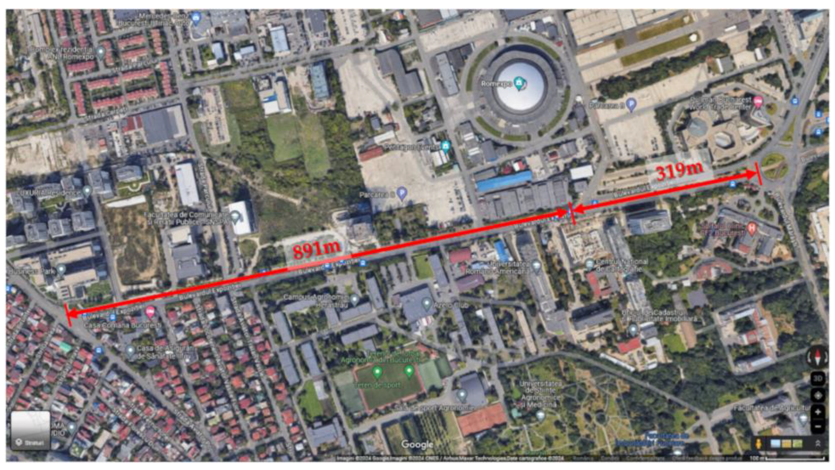
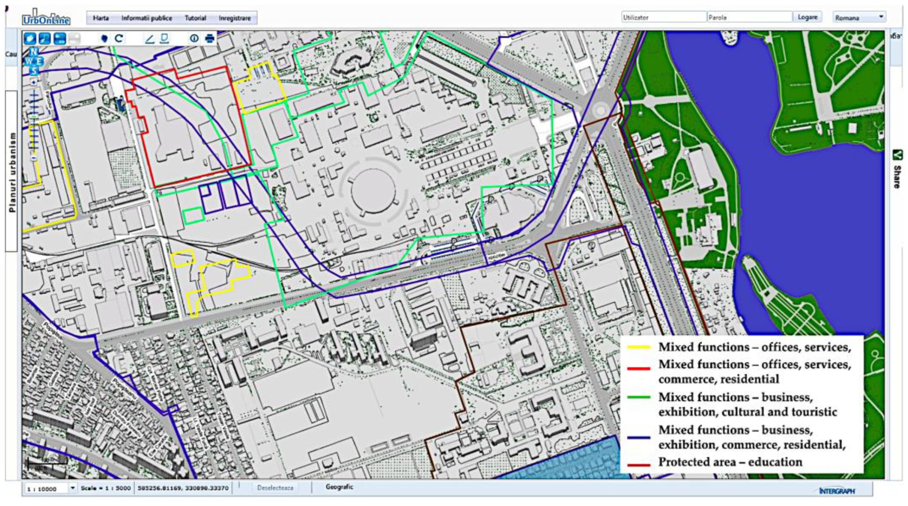
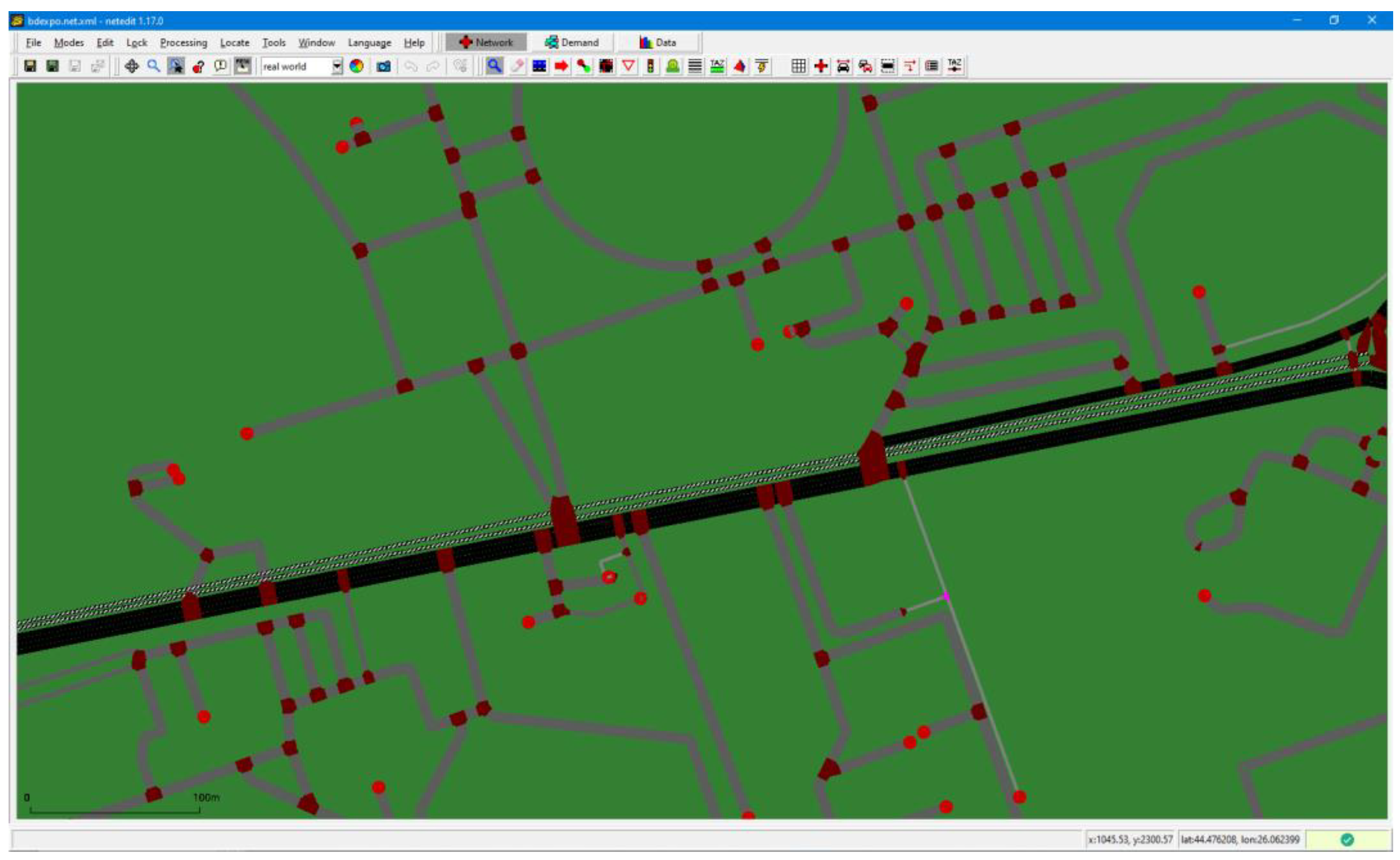
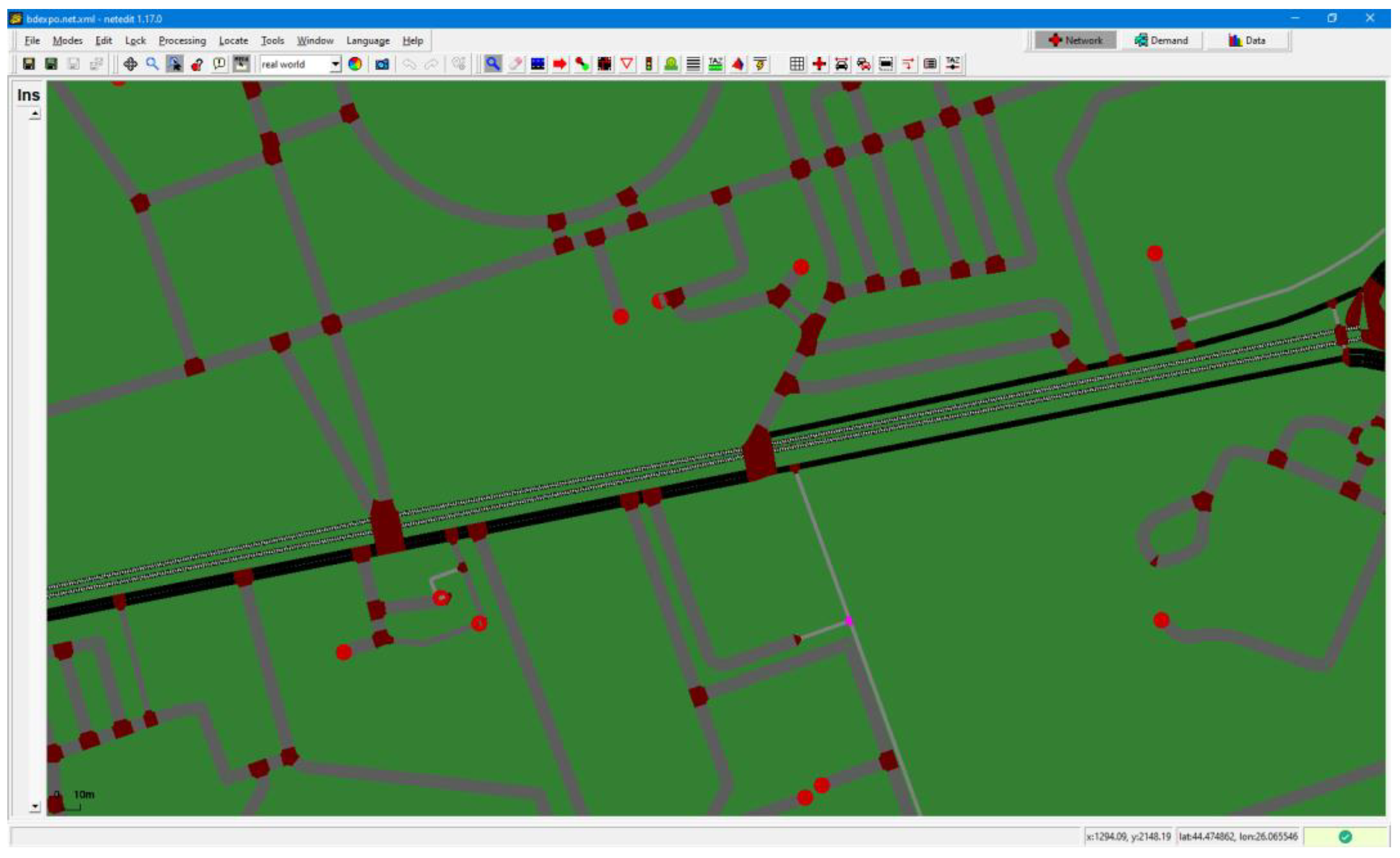
Conducting urban traffic simulations under conditions of uncertainty, like the introduction of AVs, serves as a valuable tool for testing and assessing diverse traffic management scenarios. Several simulation approaches are employed presently that rely on different models, including (i) macroscopic models, which focus on the collective dynamics of traffic elements with broader implications, such as the vehicle density; (ii) microscopic models, which delve into the individual behavior and dynamics of each traffic element; and (iii) mesoscopic models, offering a hybrid approach that incorporates elements from both macroscopic and microscopic models. Macroscopic models are appreciated for their fast execution but tend to lack accuracy. In contrast, microscopic models offer the advantage of modeling specific routes and can accurately simulate fuel consumption and emissions. They are particularly useful in contemporary research to assess the impact of AVs. Accordingly, the present research also incorporates microscopic modeling. To this end, Eclipse SUMO (Simulation of Urban Mobility) serves as the microsimulation tool of choice. SUMO [62,63,64,65,66] is well regarded for its capabilities as a powerful, open-source, and versatile simulation platform designed to handle large networks. Developed by the German Institute for Transport Systems for the evaluation of traffic infrastructure, SUMO allows the simulation of multimodal traffic networks, incorporating pedestrians, public transport, and various types of road vehicles.
The study employed ten distinct scenarios for the predictive analysis. Among these, five scenarios simulated the gradual integration of autonomous vehicles, while two were specifically designed to investigate how different parameters change as the traffic volume increases, all within the context of a Level 5 AV fleet. The final three scenarios involved reducing the number of lanes to one lane per direction while incrementally introducing Level 5 AVs per hour and direction. This set of scenarios aimed to explore the influence of these changes on various traffic parameters. The approach to scenario development and the evaluation of Connected and Autonomous Vehicles’ impact, facilitated by the open-source Microscopic Traffic Simulator SUMO and STREETMIX open-source software, is outlined in Figure 1. Streetmix [67] is an interactive web tool designed for creating streets and street networks. It visually demonstrates the street design process and serves as a valuable resource for urban planners interested in designing diverse urban environments.

2.1.1. Study Area

Bucharest is a notable example of mobility patterns in densely populated urban areas. The city features a well-developed public transportation system that enables the efficient movement of people. As per the Sustainable Urban Mobility Plan (SUMP) for Bucharest-Ilfov in 2016 [68], the modal share was estimated as follows: 36% for private car usage, 27% for public transport usage, 31% for walking, 2% for cycling, and 4% for other modes of transportation.
The simulations took place along Expozitiei Boulevard, comprising a network segment located in an area with a diverse range of urban functions (see Figure 2 and Figure 3). The study area is becoming even denser with mixed-use developments, according to the already-approved urban zonal plans [69]. The segment comprises two distinct sections, each characterized by different cross-sectional dimensions. The first section has three traffic lanes in each direction, separated by two tram tracks and a small green area with a generous pavement on the right-hand side. The second section consists of a single two-way street. The tram tracks are positioned off the streetway, incorporating a turning loop near Park Street.
The geometrical features depicted in Figure 4 were generated using STREETMIX software [67].
The traffic capacity of Expozitiei Boulevard varies due to factors such as the road design and illegal parking. STREETMIX software, according to the TUMI [71] and NACTO [72] methods, is used to calculate the passenger capacity for different transport modes. According to these methodologies, Figure 5 and Figure 6 illustrate the passenger capacities for the two sections under consideration. These capacities serve as an initial reference point for the assessment of the transport capacity changes due to the introduction of a fully autonomous vehicle fleet. Peak traffic occurs in the late afternoon with varying speeds depending on the sections. Public transport includes bus line 105 (4 vehicles/hour per direction) and tram line 3 (1 vehicle/hour per direction), which has a separate track that is suitable for potential autonomous transport initiatives.

2.1.2. Network Preparedness

The construction of Expozitiei Blvd and its associated street network was carried out following the technique outlined in [73,74]. Street maps were generated by extracting data from OpenStreetMaps.org [75] and converting the downloaded .osm file to .xml format. Further refinement was performed using SUMO NetEdit, involving adjustments to road speeds, lane merging, vehicle behavior at intersections, and traffic signal timing (based on measurements conducted in March 2023). To facilitate the simulation’s execution, network configuration, and trips, XML files were generated. Network configuration XML files represented the testbed for the simulations, input data from trips’ XML files were utilized, and output files for post-simulation data analysis were specified. Trips’ XML files contain detailed information about vehicle types, routes for vehicles, and the traffic flow on defined routes. The output files, such as trip information, duration, waiting time, time loss, and emissions were generated after the running of each simulation in XML format and converted into a csv file for facilitation of the analysis. For the most part, static traffic generation was used across all scenarios (Figure 7 and Figure 8), maintaining consistent traffic levels (both in terms of time and volume) on the same map for each situation.
A dual-phase approach was conducted from the street configuration point of view to replicate transportation scenarios involving connected and autonomous vehicles. In the initial phase of the simulations, we retained the existing layout of the two sections along Expozitiei Blvd. However, in the second phase, we intentionally reduced the number of traffic lanes to just one lane for each direction. The primary goal of this study was to evaluate the viability of reducing the number of lanes in a traffic scenario exclusively featuring autonomous and connected vehicles. We aimed to determine how much we could increase the transportation capacity without causing traffic congestion while also creating more room for active mobility.

2.1.3. Scenarios’ Set-Up

The market penetration of AVs has gained extensive attention in academic research, with estimates varying based on factors like the technological maturity and consumer adoption. One analysis [26] anticipates 50% autonomous vehicle adoption by 2045. An additional study by Catapult [76] presents optimistic and pessimistic scenarios, indicating that Level 4/5 autonomous vehicles could achieve penetration rates of approximately 30% and 3%, respectively.
This research examines ten scenarios to assess the impacts of autonomous and connected vehicles on traffic, urban spaces, and the environment with a focus on gradual integration and lane reduction scenarios along Expozitiei Blvd (Table 1). Scenarios 1 to 7 focus on the gradual introduction of AVs into the market, utilizing the existing infrastructure of Expozitiei Blvd. Meanwhile, scenarios 8 to 10 explore varying vehicle flows by reducing the number of lanes in each direction along the same boulevard.

2.1.4. Emission Modeling in SUMO

The emission calculation [77] follows a general formula based on the energy consumption rate:
P = c0 + c1va + c2va2 + c3v + c4v2 + c5v4
In this formula,
  • ci = constant parameters specific to the vehicle type;
  • v = speed;
  • a = acceleration.

3. Results of the Simulation Using Different AV Market Penetration Scenarios and Discussion

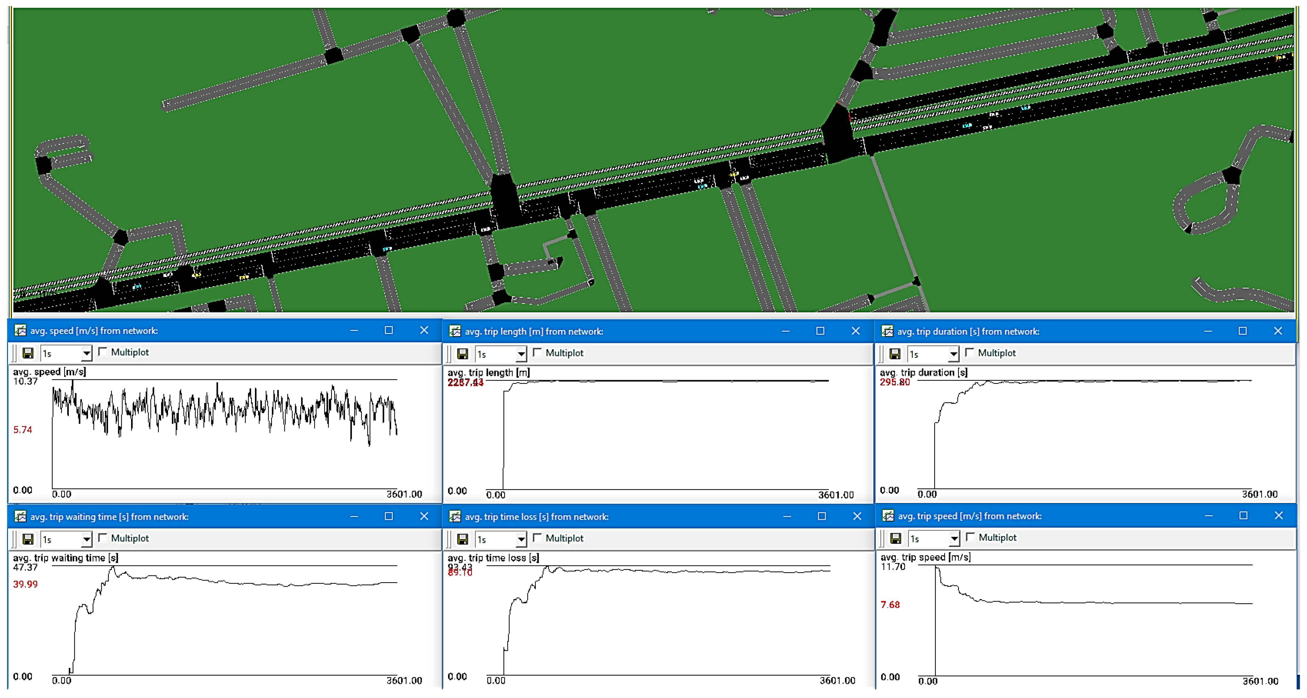
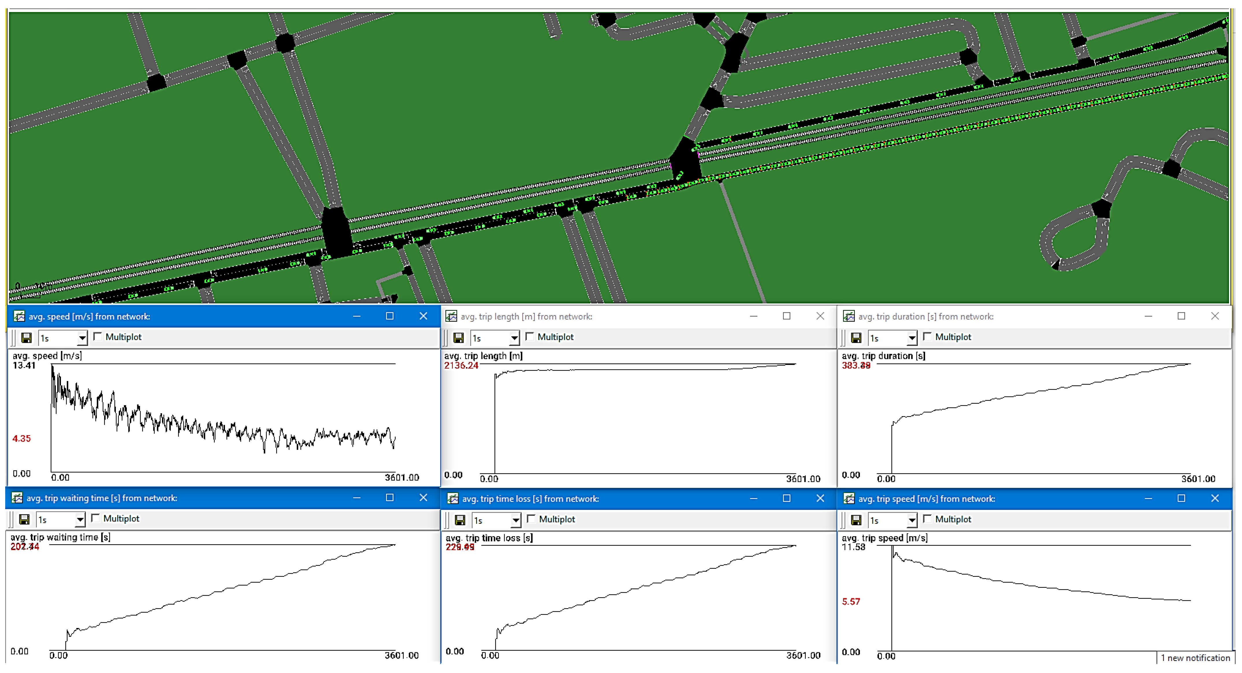
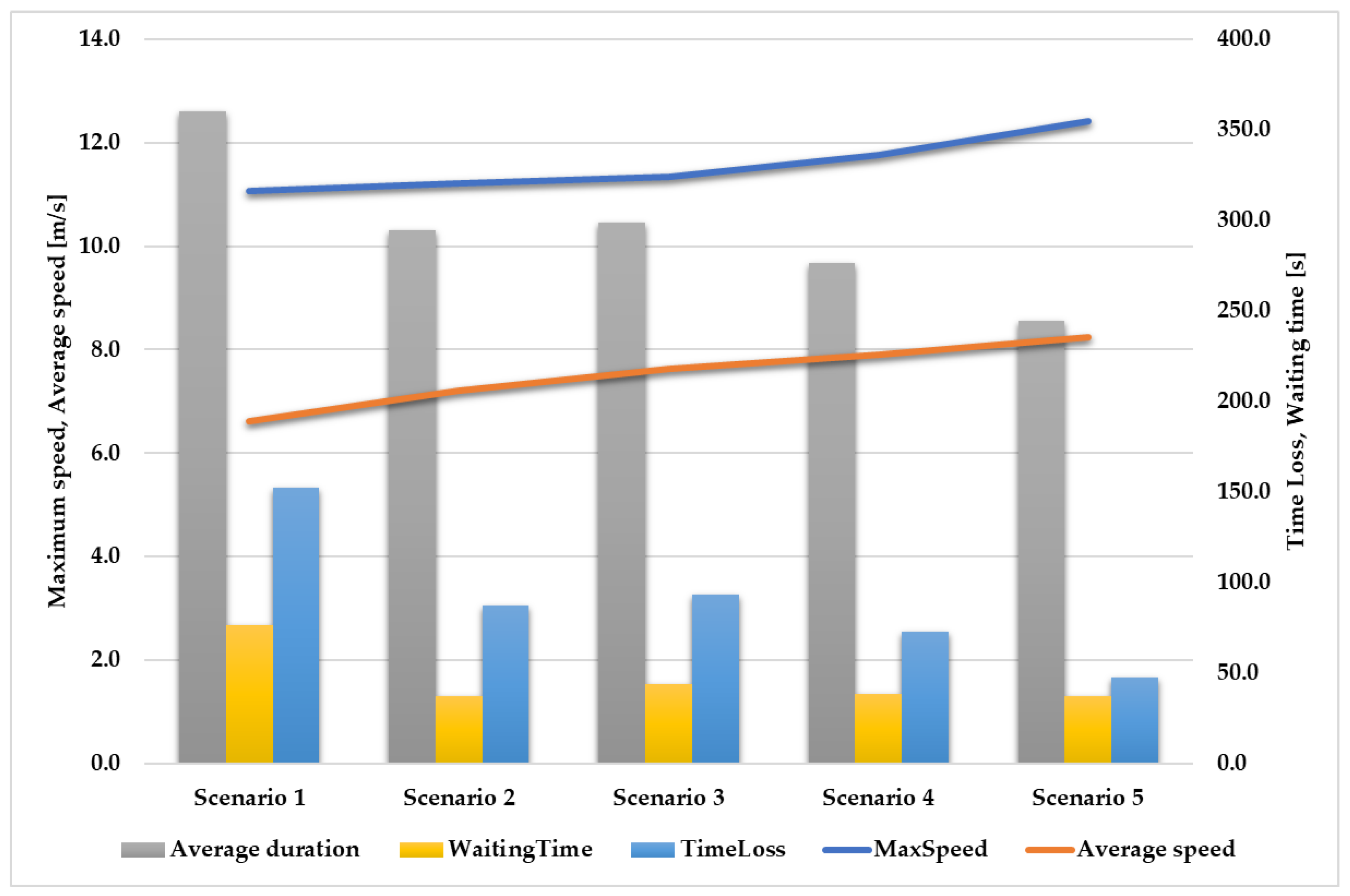
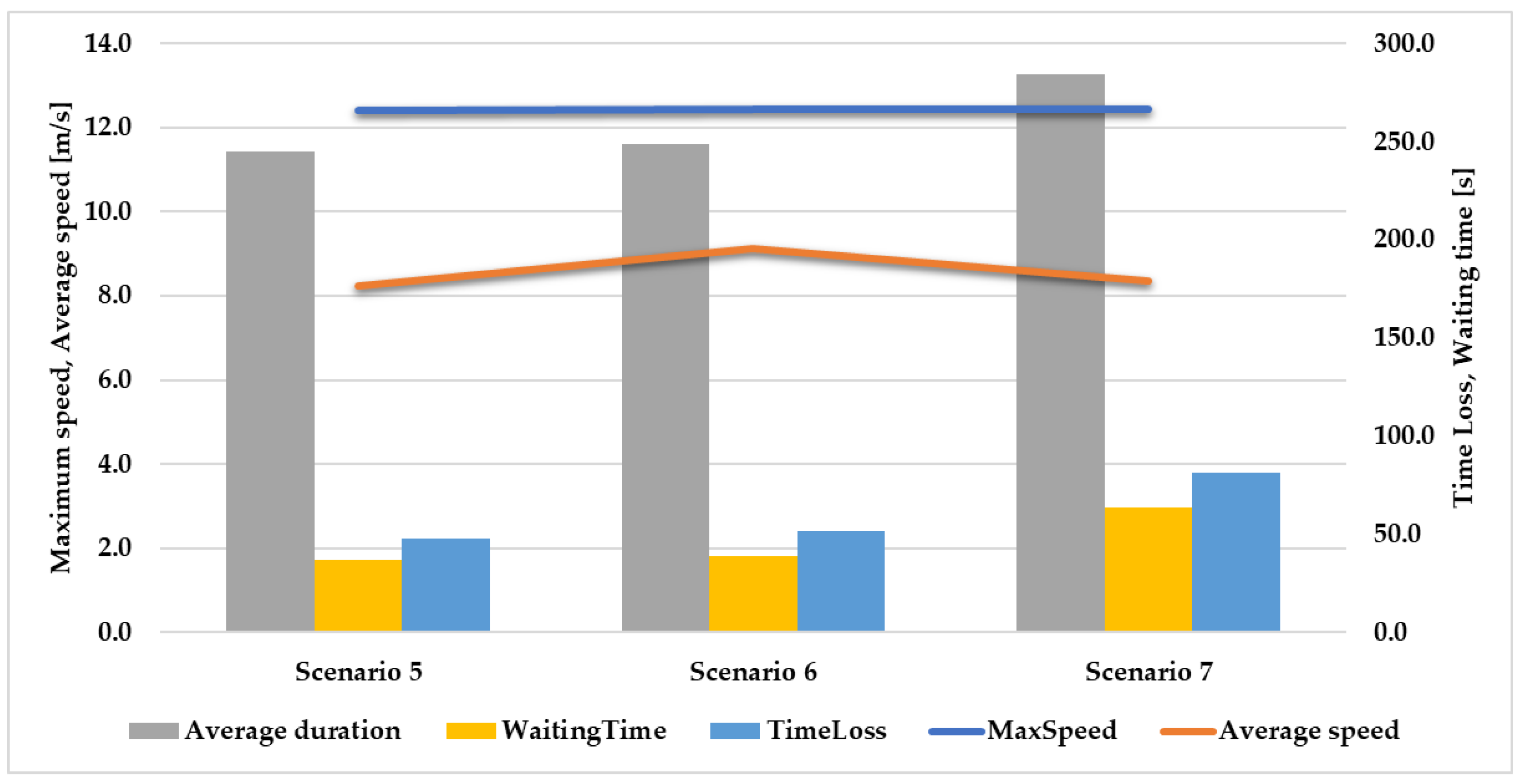
3.1. Results of the Simulation Using Different AV Market Penetration Scenarios

3.1.1. Traffic-Related Parameters

In the initial phase of our investigation, we performed a total of seven simulations using the existing network model. The first five simulations were performed with a traffic flow of 500 vehicles per hour in each direction. In the last two simulations of this phase, we considered the possibility of increasing the traffic volume with Level 5 vehicles from 500 vehicles per hour in each direction to 750 vehicles per hour and then to 1000 vehicles per hour. Each simulation lasted 3600 s, and it is important to emphasize that we used the full carrying capacity of the roadway in our simulations. It is worth noting that, in practice, the first lane in each direction is often used for parking, even in areas where such use is prohibited.
Figure 9 and Figure 10 illustrate simulations 3 and 9 (see Table 1 above), along with the variations in the time-related parameters, including the average travel waiting time, average travel time, average travel time loss, and average travel speed. To differentiate between the different levels of vehicle autonomy, specific colors were assigned: non-autonomous vehicles in yellow, Level 1 in blue, Level 2 in white, Level 3 in orange, Level 4 in purple, and Level 5 in green. Figure 11 provides comparisons related to the travel speed, duration, queuing time, and waiting time. The results of the study indicate a positive correlation between the penetration rate of AVs and the maximum speed of all vehicles. A notable increase in the maximum speed is observed in scenarios 2–5. It is important to note that this growth rate is not linear due to the different levels of automation. Specifically, AVL1 and AVL2 have moderately favorable impacts on speed, while AVL3 has a negligible influence. Scenario 5 stands out with the highest average maximum speed, reaching 12.43 km/h, as all vehicles in this scenario are equipped with AVL5.
The study also suggests that an increase in the adoption rate of autonomous vehicles may have a positive effect on the average traffic speed. However, the introduction of autonomous vehicles with a lower degree of automation may have a negative impact on the average speed, especially when sharing the road with non-autonomous vehicles. As the level of automation decreases, the performance of autonomous vehicles in terms of speed and their compatibility with non-autonomous vehicles is negatively affected.
Further, the research shows that, as the proportion of autonomous vehicles increases, the average trip duration, waiting time, and time loss decrease. Scenario 5 (Figure 12), with exclusively AVL5 vehicles, demonstrates the shortest trip duration, suggesting that an all-autonomous vehicle fleet can boost the traffic efficiency. Waiting times vary by scenario, with the smallest time loss occurring in Scenario 5 (all AVL5 vehicles) and the largest occurring in Scenario 1 (25% AVL1 and AVL2). The study highlights the ability of autonomous and connected vehicles to maintain a consistent and efficient speed, reaching a maximum speed of 12.45 m/s, even with increased traffic, within typical urban road speed limits.
The simulations reveal that the average speed of autonomous vehicles decreases with higher traffic volumes, indicating challenges with maintaining service levels during times of peak demand, possibly due to defensive driving or road capacity limits. More autonomous vehicles lead to longer trip durations, suggesting a limit on their effective numbers without causing significant delays. As the traffic volume increases, waiting times and time loss also grow. In the second phase with a single lane per direction but the same traffic volume, autonomous vehicles maintain their efficiency and safety with consistent speeds. However, a speed improvement is notable in scenarios 8 and 9, while a drop in scenario 10 might result from a cautious driving approach and road network misalignment with traffic signals (Figure 13). The study suggests that enhancing the critical traffic density might require fewer than 50% more autonomous vehicles, prompting the need to reshape urban spaces to prioritize active modes and green areas. However, when the metro line is available in the area, it is anticipated that the surface transport demand will diminish.

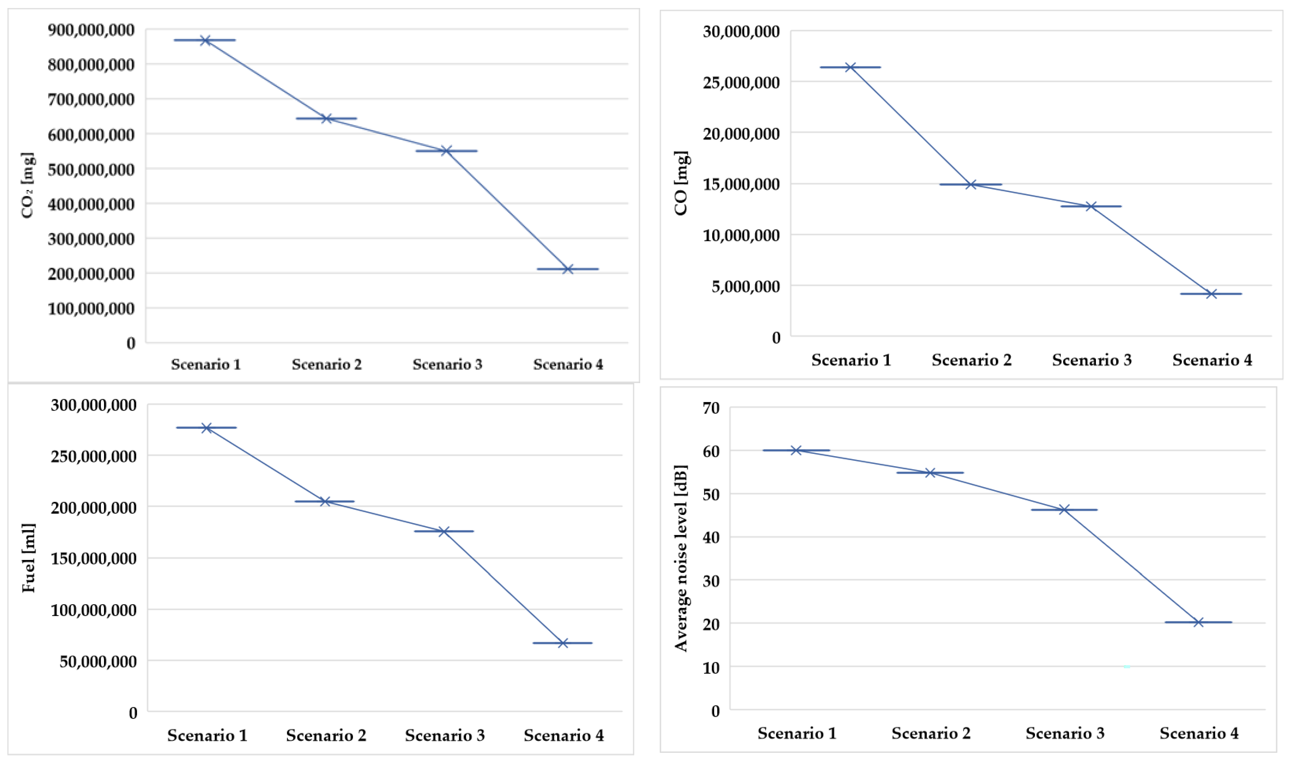
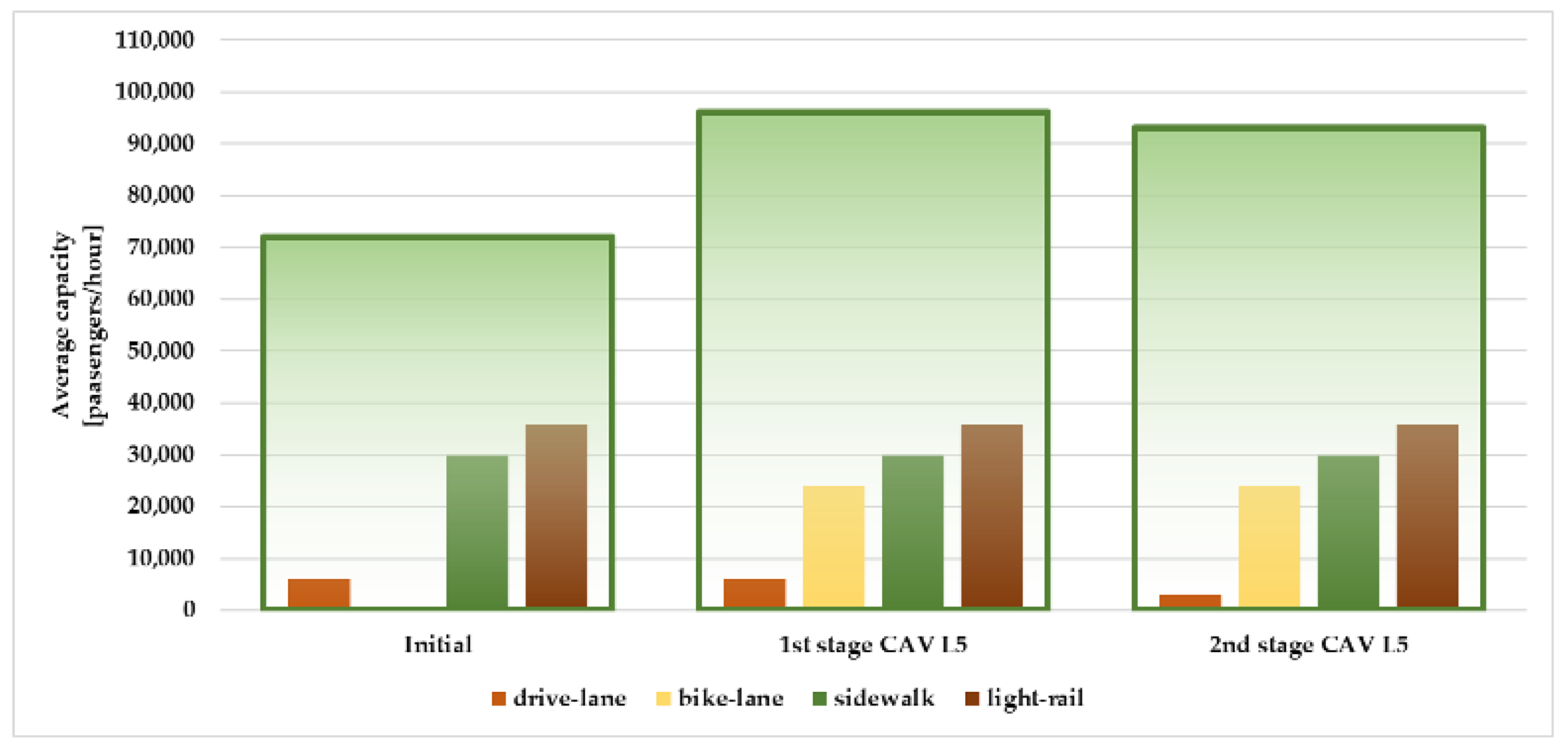
3.1.2. Emissions, Fuel Consumption, and Noise

The research assesses emissions, fuel consumption, and noise levels across scenarios 1 to 4, encompassing a spectrum of fully autonomous vehicles. The findings underscore a tangible reduction in pollution indicators, as the penetration of connected and autonomous vehicles rises. Notably, the scenario with the most favorable environmental impact is scenario 4, where no non-autonomous vehicles are present, and only vehicles ranging from Levels 1 to 5 operate autonomously. Within this context, it is evident that the degree of vehicle automation plays a pivotal role in determining their emissions profile. Specifically, higher levels of automation correlate with significantly lower emissions, even reaching zero emissions in some cases. Conversely, vehicles with lower levels of automation exhibit higher emissions levels, highlighting a direct relationship between automation technology and environmental benefits. These data underscore the substantial potential of fully autonomous vehicles, particularly those at the highest automation levels, to mitigate environmental pollution and promote cleaner and more sustainable transportation systems (Figure 14).

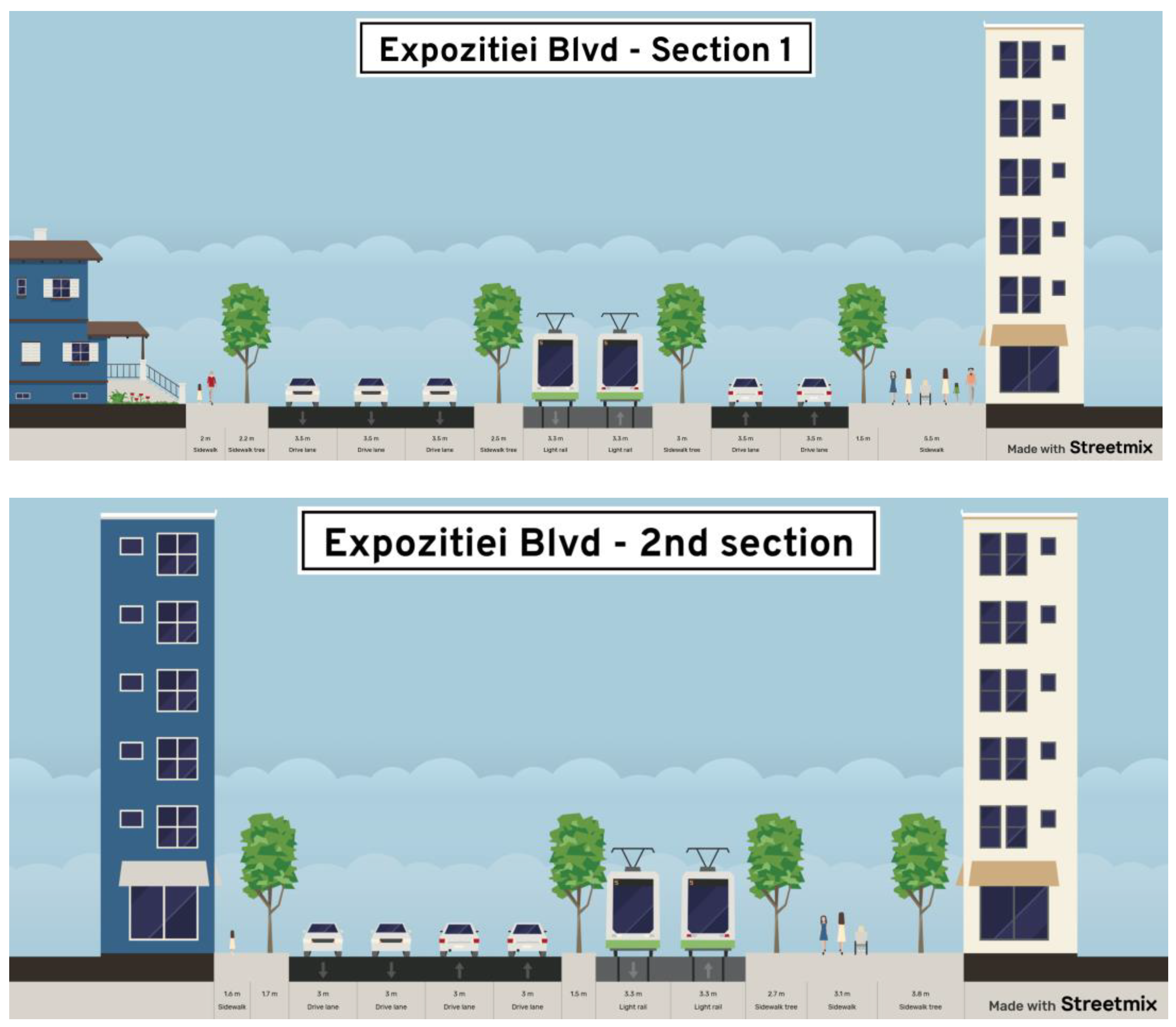
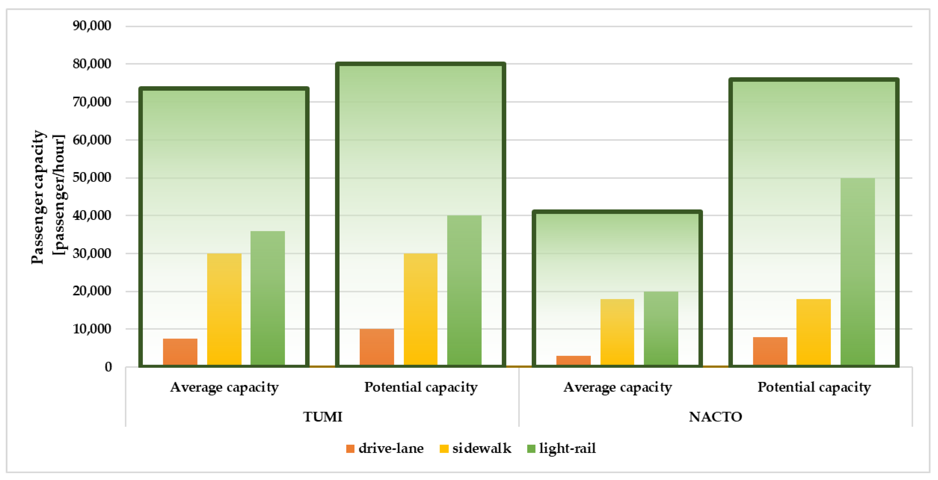
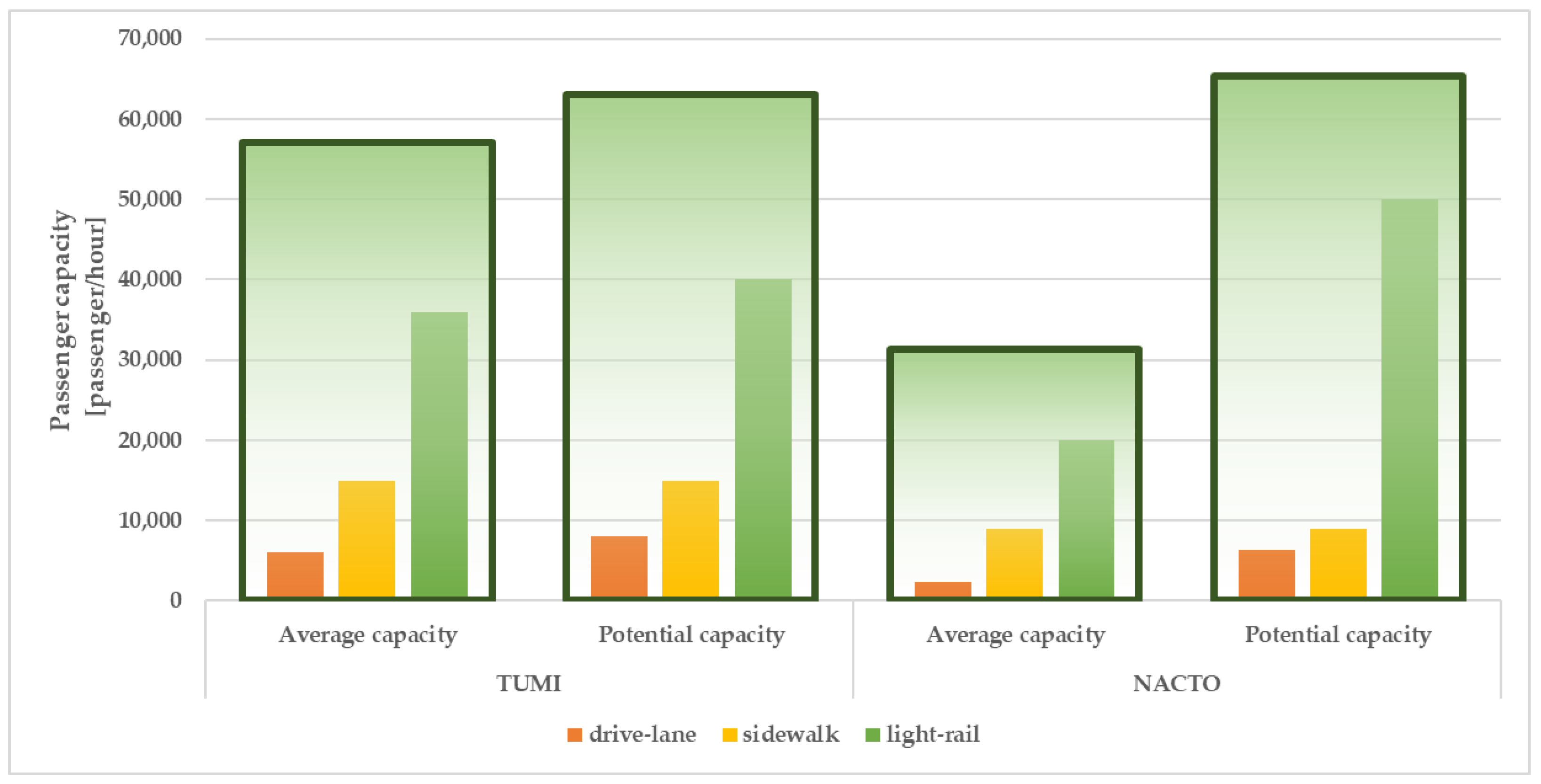
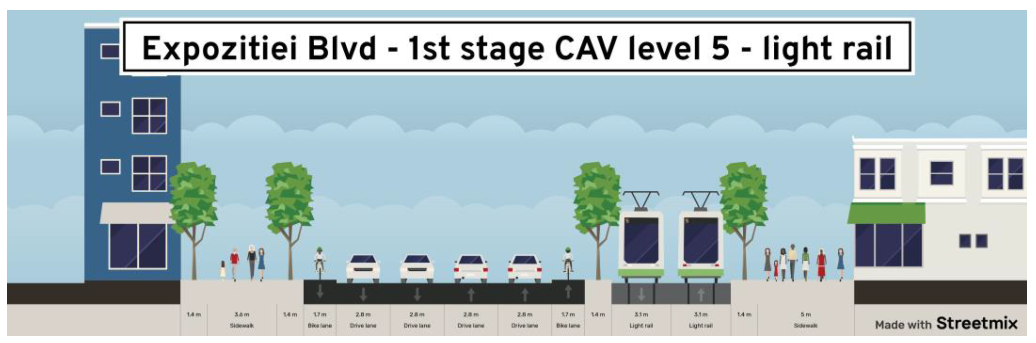
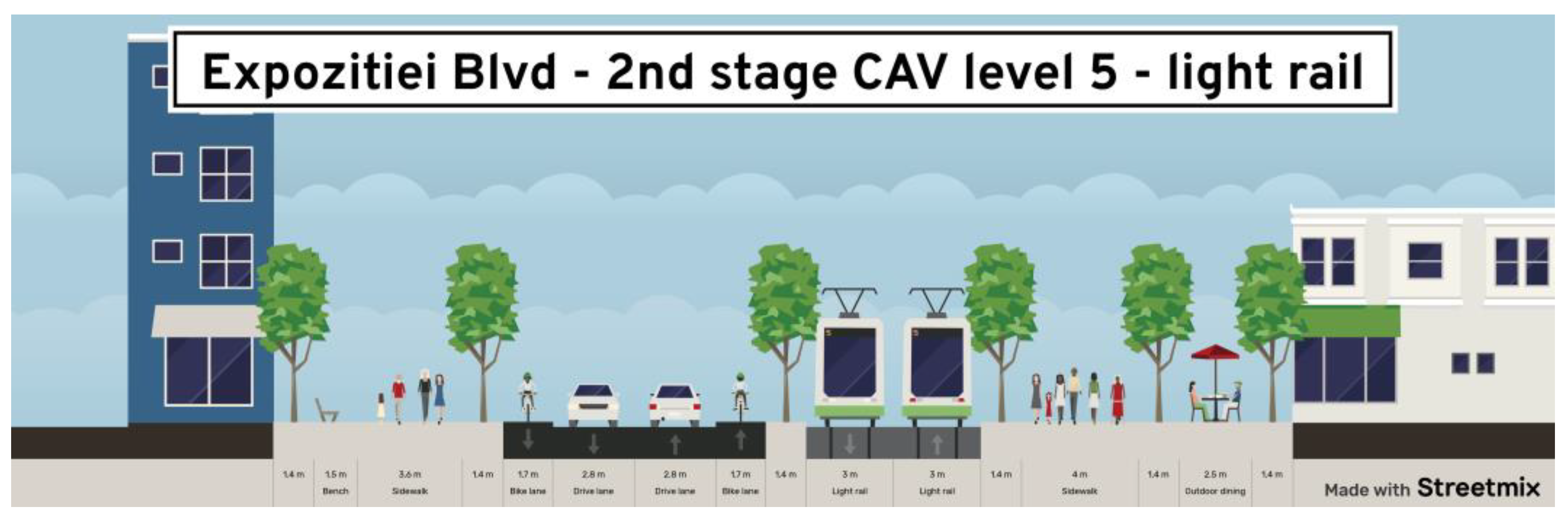
3.2. Street Redesign

We propose a two-stage reorganization of the urban space in the studied area. In the first stage, we recommend the transformation of the current road network by reducing it to two narrow lanes, the introduction of two dedicated bicycle lanes, and the reallocation of space away from public transportation lanes. Additionally, we suggest that the number of traffic lanes is reduced to a single lane in each direction. Our main objective is to enhance the capacity for active modes of transportation, create more pedestrian-friendly areas, and allocate space for green areas. Furthermore, we consider light rail transportation as a viable option for public transport. During the adaptation stage, one of the existing five lanes is removed, and vehicle lanes are consolidated into a single section. The dedicated public transport lane is reduced to 3.1 m in each direction (considering that AVs require less maneuvering space due to their improved lateral control), resulting in an 11.2 m wide roadway. Two bicycle lanes, with a width of 1.7 m each, are introduced alongside the road, and pedestrian and green spaces are expanded. The new configuration is outlined in Figure 15.
In the consolidation stage, the road is transformed into a single traffic lane in each direction, with each lane measuring 2.8 m [73,78]. The dedicated public transport lane is reduced to 3.0 m in each direction, while the two bicycle lanes are retained. This change significantly increases pedestrian areas, including recreational spaces, which grow by 57%, and green spaces, which now cover 68% of the area (Figure 16).
In the initial phase, a 30% reduction in the automobile space led to the creation of two bicycle lanes, an expansion of the pedestrian space by 16%, and a 12% increase in green space. In the second phase, the vehicle space was reduced by 65%, resulting in 57% growth in the pedestrian space, which includes recreational areas. Further, green space now constitutes 68% of the area, as indicated in Table 2.
Figure 17 depicts pedestrian and transportation capacities for both stages and under the TUMI calculation mode [71]. These capacities show improvement, with a 33.3% increase in the first stage and an 18.6% increase in the second stage when light rail is utilized as a public transportation option. The results suggest that reducing the number of lanes for vehicles can potentially enhance the transportation capacity through more efficient street area restructuring.
The simulation results suggest that, with the adoption of fully autonomous vehicles, there will be room for reducing the number of lanes to optimize the traffic volume. As AVs are expected to have a lower environmental impact, this shift would also lead to a decrease in polluting emissions. This transformation allows for the reconfiguration of physical space, making way for dedicated bicycle lanes and expanding pedestrian areas. Moreover, it facilitates the inclusion of more green spaces, which aligns with findings from prior research [79,80,81,82]. Additionally, this reconfiguration notably increases the overall transport capacity per section, albeit at the expense of reduced space for car circulation. Thus, the hypothesis is confirmed: the introduction of AV transportation in Bucharest opens up opportunities to reshape the urban space while having a positive impact on the environment.

4. Conclusions

Currently, autonomous guided transport systems like metros, trains, and trams operate on dedicated infrastructure, separate from general traffic networks. As we transition toward full market adoption of autonomous and connected vehicles, it will be vital to introduce traffic segregation measures with a particular emphasis on autonomous mass transportation. The integration of autonomous vehicles (AVs) into urban areas presents multifaceted challenges across the transportation, infrastructure, construction, environment, society, and policy domains.
This paper takes a comprehensive approach that extends beyond the technical intricacies of AVs to encompass their broader implications on urban design and transportation infrastructure. Utilizing a sophisticated methodology involving open-source software tools like SUMO and STREETMIX (explained in the methods section), the study examines the outcomes of simulations that anticipate AV implementation under various market penetration scenarios.
The simulations conducted indicate that the introduction of autonomous vehicles in Bucharest has the potential to significantly improve the traffic conditions and overall environmental factors, thus addressing the research question. Furthermore, the conversion of traffic lanes into dedicated bicycle and pedestrian areas will enable a fundamental reconfiguration of the urban space, supporting the initial hypothesis. It is essential to note that this study focused solely on car traffic and did not encompass elements associated with shared transportation.
The paper puts forth innovative urban design strategies that could harness the full potential of AVs, promoting the development of sustainable and resilient cities. Through the exploration of these design approaches, we aim to offer valuable guidance for urban planners and policymakers as they navigate the challenges and opportunities presented by the integration of these advanced technologies. Finally, the findings of this research emphasize that the integration of autonomous vehicles into the urban environment is a complex endeavor, presenting various challenges.
The methodology employed in this study can be readily replicated in diverse locations, both within Romania and internationally. This flexibility allows for the adaptation and application of the research approach to various urban settings, making it a valuable tool for assessing the impact of AVs on urban mobility in a wide range of regions.
Nevertheless, a limitation arises due to the restricted scope of the simulation conducted exclusively on a small street segment, potentially impacting the generalizability and wider applicability of the study findings to more complex or varied urban environments. The paper serves as a simulation that is specific to a particular situation and a distinct mode of transportation within a specific context and should be perceived as a demonstration, rather than as a methodology for conducting traffic studies.
Future research will involve modeling the street network of the neighborhood in anticipation of upcoming construction projects. Additional investigation is planned to explore on-demand shared transportation using AVs. This research will take into consideration the overall transport capacity considering the forthcoming metro line that will support and enhance the transportation infrastructure.

Author Contributions

Conceptualization, Liliana Andrei and Oana Luca; Methodology, Liliana Andrei and Oana Luca; Software, Liliana Andrei; Validation, Liliana Andrei; Formal analysis, Liliana Andrei; Investigation, Liliana Andrei and Oana Luca; Resources, Oana Luca; Writing—original draft, Liliana Andrei and Oana Luca; Writing—review and editing, Oana Luca; Visualization, Liliana Andrei and Oana Luca; Supervision, Oana Luca; Project administration, Oana Luca; Funding acquisition, Oana Luca. All authors have read and agreed to the published version of the manuscript.

Funding

This research received no external funding.

Data Availability Statement

Data are contained within the article.

Conflicts of Interest

The authors declare no conflict of interest.

References

  1. J3016C: Taxonomy and Definitions for Terms Related to Driving Automation Systems for On-Road Motor Vehicles—SAE International. Available online: https://www.sae.org/standards/content/j3016_202104/ (accessed on 21 October 2023).
  2. ADAS&ME. Vision. ADAS&ME. Available online: https://www.adasandme.com/about-adasme/vision/ (accessed on 23 October 2023).
  3. IRT SystemX. 3SA. Available online: https://www.irt-systemx.fr/projets/3sa/ (accessed on 23 October 2023).
  4. Show-Project.EU. Available online: https://show-project.eu/ (accessed on 23 October 2023).
  5. Digibus Austria. Digibus® Austria. Available online: https://www.digibus.at/en/ (accessed on 23 October 2023).
  6. Capri Mobility. Available online: http://caprimobility.com (accessed on 23 September 2023).
  7. CoEXist. Working towards a Shared Road Network. Available online: https://www.h2020-coexist.eu/ (accessed on 29 October 2023).
  8. Assuring the Safety of Connected and Autonomous Vehicles. Connected Places Catapult. Available online: https://cp.catapult.org.uk/report/assuring-the-safety-of-connected-and-autonomous-vehicles/ (accessed on 23 October 2023).
  9. Oelgemöller, S. Startseite. Art-Forum. Available online: https://www.art-forum.eu/ (accessed on 23 October 2023).
  10. LivingLAPT. EIT Urban Mobility. Available online: https://www.eiturbanmobility.eu/projects/livinglapt/ (accessed on 23 October 2023).
  11. Ride2Autonomy EU Project Learning Connection—SUMMALab. Available online: https://summalab.nl/r2a/ (accessed on 23 October 2023).
  12. PAV, Interreg VB North Sea Region Programme. Available online: https://northsearegion.eu/pav/ (accessed on 23 October 2023).
  13. TRL|STREETWISE—Creating an Automated Personal Mobility Solution for London Commuters. Available online: https://trl.co.uk/projects/streetwise---creating-an-automated-personal-mobility-solution-for-london-commuters (accessed on 23 October 2023).
  14. Maven-Its.EU. Available online: http://www.maven-its.eu/ (accessed on 23 October 2023).
  15. Hi-Drive Deployment of Higher Automation. Available online: https://www.hi-drive.eu/ (accessed on 23 October 2023).
  16. CARAMEL—Artificial Intelligence Based Cybersecurity for Connected and Automated Vehicles. Available online: https://www.h2020caramel.eu/ (accessed on 23 October 2023).
  17. 5G-DRIVE—5G HarmoniseD Research and TrIals for serVice Evolution between EU and China. Available online: https://5g-drive.eu/ (accessed on 23 October 2023).
  18. Autopilot. Available online: https://autopilot-project.eu/ (accessed on 23 October 2023).
  19. Automated Driving Applications and Technologies for Intelligent Vehicles—AdaptIVe FP7 Project-Automated Driving Applications and Technologies for Intelligent Vehicles. Available online: https://www.adaptive-ip.eu/ (accessed on 23 October 2023).
  20. 5GCroCo. Available online: https://5gcroco.eu/ (accessed on 23 October 2023).
  21. Hadrian Project|Holistic Approach for Driver Role Integration and Automation Allocation for European Mobility Needs. Available online: https://hadrianproject.eu/ (accessed on 23 October 2023).
  22. AWARD H2020—Scaling Autonomous Logistics. Available online: https://award-h2020.eu/ (accessed on 20 October 2023).
  23. 5G-MOBIX. Available online: https://www.5g-mobix.com/resources/presentations/5g-mobix-5g-for-cooperative-connected-automated-mobility-on-x-border-corridors (accessed on 23 October 2023).
  24. ENSEMBLE|Platooning Together. Available online: https://platooningensemble.eu/ (accessed on 23 October 2023).
  25. ERTRAC Working Group “Connectivity and Automated Driving”. Connected Automated Driving Roadmap; European Road Transport Research Advisory Council: Brussels, Belgium, 2019; p. 56. Available online: https://www.ertrac.org/wp-content/uploads/2022/07/ERTRAC-CAD-Roadmap-2019.pdf (accessed on 16 August 2023).
  26. Litman, T. Autonomous Vehicle Implementation Predictions Implications for Transport Planning; Victoria Transport Policy Institute: Victoria, BC, Canada, 2022; p. 48. [Google Scholar]
  27. Bansal, P.; Kockelman, K.M. Forecasting Americans’ long-term adoption of connected and autonomous vehicle technologies. Transp. Res. Part A Policy Pract. 2017, 95, 49–63. [Google Scholar] [CrossRef]
  28. What’s Next for Autonomous Vehicles?|McKinsey. Available online: https://www.mckinsey.com/features/mckinsey-center-for-future-mobility/our-insights/whats-next-for-autonomous-vehicles (accessed on 25 October 2023).
  29. Lutin, J. Not If, but When: Autonomous Driving and the Future of Transit. J. Public Transp. 2018, 21, 92–103. [Google Scholar] [CrossRef]
  30. Juliussen, E.; Carlson, J. Autonomous Cars: Not if But When; IHS Automotiv: Northville, MI, USA, 2014; p. 4. [Google Scholar]
  31. Farah, H.; Erkens, S.M.J.G.; Alkim, T.; van Arem, B. Infrastructure for Automated and Connected Driving: State of the Art and Future Research Directions. In Road Vehicle Automation 4; Lecture Notes in Mobility; Meyer, G., Beiker, S., Eds.; Springer International Publishing: Cham, Switzerland, 2018; pp. 187–197. [Google Scholar]
  32. Manivasakan, H.; Kalra, R.; O’Hern, S.; Fang, Y.; Xi, Y.; Zheng, N. Infrastructure requirement for autonomous vehicle integration for future urban and suburban roads—Current practice and a case study of Melbourne, Australia. Transp. Res. Part A Policy Pract. 2021, 152, 36–53. [Google Scholar] [CrossRef]
  33. Cucor, B.; Petrov, T.; Kamencay, P.; Pourhashem, G.; Dado, M. Physical and Digital Infrastructure Readiness Index for Connected and Automated Vehicles. Sensors 2022, 22, 7315. [Google Scholar] [CrossRef]
  34. Hirose, J. Digital Infrastructure Service Role and Functional Model for Urban ITS Service Applications. 11 August 2022. Available online: https://wwww.easychair.org/publications/preprint/cCnv (accessed on 5 October 2023).
  35. Kimmel, S.; Duran, A.; Robertson, J.; Vanderveen, M.; Wending, B. Physical and Digital Infrastructure for Connected and Automated Vehicles (CAV)—Code Framework; Canadian Standards Association: Toronto, ON, Canada, 2021; p. 52. Available online: https://www.csagroup.org/wp-content/uploads/CSA-Group-Research-Physical-and-Digital-Infrastructure-for-Connected-and-Automated-Vehicles-CAV.pdf (accessed on 21 June 2023).
  36. Crute, J.; Riggs, W.; Chapin, T.S.; Stevens, L. Planning for Autonomous Mobility; PAS Report; American Planning Association: Chicago, IL, USA, 2018; p. 84. [Google Scholar]
  37. Tengilimoglu, O.; Carsten, O.; Wadud, Z. Implications of Automated Vehicles for Physical Road Environment: A Comprehensive Review. Transp. Res. Part E Logist. Transp. Rev. 2023, 169, 102989. [Google Scholar] [CrossRef]
  38. Khan, A.R.; Jamlos, M.F.; Osman, N.; Ishak, M.I.; Dzaharudin, F.; Yeow, Y.K.; Khairi, K.A. DSRC Technology in Vehicle-to-Vehicle (V2V) and Vehicle-to-Infrastructure (V2I) IoT System for Intelligent Transportation System (ITS): A Review. In Recent Trends in Mechatronics Towards Industry 40; Lecture Notes in Electrical Engineering; Nasir, A.F.A., Ibrahim, A.N., Ishak, I., Mat Yahya, N., Zakaria, M.A., Abdul Majeed, A.P.P., Eds.; Springer: Singapore, 2022; pp. 97–106. [Google Scholar]
  39. Harte, S. Reflective Measurement Systems RetroTek. 2016 Future-Proofing Road Markings. Available online: https://www.reflective-systems.com/future-proofing-road-markings/ (accessed on 28 September 2023).
  40. Duvall, T.; Hannon, E.; Katseff, J.; Safran, B.; Wallace, T. A new look at autonomous-vehicle infrastructure|McKinsey. In What Infrastructure Improvements Will Promote the Growth of Autono-Mous Vehicles While Simultaneously Encouraging Shared Ridership? McKinsey & Company: Chicago, IL, USA, 2019; p. 6. Available online: https://www.mckinsey.com/industries/travel-logistics-and-infrastructure/our-insights/a-new-look-at-autonomous-vehicle-infrastructure (accessed on 28 October 2023).
  41. Gerike, R.; Dean, M.; Koszowski, C.; Schröter, B.; Wittwer, R.; Weber, J.; Jones, P. MORE Deliverable D1. 2 Urban Corridor Road Design: Guides, Objectives and Performance Indicators. 2019. Available online: https://www.roadspace.eu/wp-content/uploads/2019/11/MORE_D1_2_FINAL.pdf (accessed on 23 May 2023).
  42. Dennis, E.P.; Spulber, A.; Sathe Brugerman, V.; Kuntzsch, R.; Neuner, R. Planning for Connected and Automated Vehicles. Technology Research. 2017. Available online: https://www.cargroup.org/publication/planning-for-connected-and-automated-vehicles/ (accessed on 28 October 2023).
  43. Tientrakool, P.; Ho, Y.C.; Maxemchuk, N.F. Highway Capacity Benefits from Using Vehicle-to-Vehicle Communication and Sensors for Collision Avoidance. In Proceedings of the 2011 IEEE Vehicular Technology Conference (VTC Fall), San Francisco, CA, USA, 5–8 September 2011; pp. 1–5. [Google Scholar]
  44. Kisner, C.; Fillin-Yeh, K.; Bharadwaj, S.; Schmidt, C.; Abdulsamad, M.; Engel, A. Blueprint for Autonomous Urbanism Second Edition. NACTO. 2019. Available online: https://nacto.org/publication/bau2/transit/ (accessed on 23 September 2023).
  45. Miller, S.A.; Heard, B.R. The Environmental Impact of Autonomous Vehicles Depends on Adoption Patterns. Environ. Sci. Technol. 2016, 50, 6119–6121. [Google Scholar] [CrossRef]
  46. Fagnant, D.J.; Kockelman, K.M. The travel and environmental implications of shared autonomous vehicles, using agent-based model scenarios. Transp. Res. Part C Emerg. Technol. 2014, 40, 1–13. [Google Scholar] [CrossRef]
  47. Kopelias, P.; Demiridi, E.; Vogiatzis, K.; Skabardonis, A.; Zafiropoulou, V. Connected & autonomous vehicles—Environmental impacts—A review. Sci. Total Environ. 2020, 71, 135237. [Google Scholar] [CrossRef]
  48. Nunes, P.; Figueiredo, R.; Brito, M.C. The use of parking lots to solar-charge electric vehicles. Renew. Sustain. Energy Rev. 2016, 66, 679–693. Available online: https://www.sciencedirect.com/science/article/pii/S1364032116304294 (accessed on 9 August 2023). [CrossRef]
  49. González-González, E.; Nogués, S.; Stead, D. Parking Futures: Preparing European Cities for the Advent of Automated Vehicles. Land Use Policy 2020, 91, 104010. [Google Scholar] [CrossRef]
  50. Neufville, R.; Abdalla, H.; Abbas, A. Potential of Connected Fully Autonomous Vehicles in Reducing Congestion and Associated Carbon Emissions. Sustainability 2022, 14, 6910. [Google Scholar] [CrossRef]
  51. Metz, D. Developing Policy for Urban Autonomous Vehicles: Impact on Congestion. Urban Sci. 2018, 2, 33. [Google Scholar] [CrossRef]
  52. Makridis, M.; Mattas, K.; Mogno, C.; Ciuffo, B.; Fontaras, G. The impact of automation and connectivity on traffic flow and CO2 emissions. A detailed microsimulation study. Atmos. Environ. 2020, 226, 117399. [Google Scholar] [CrossRef]
  53. Rafael, S.; Correia, L.P.; Lopes, D.; Bandeira, J.; Coelho, M.C.; Andrade, M.; Borrego, C.; Miranda, A.I. Autonomous vehicles opportunities for cities air quality. Sci. Total Environ. 2020, 712, 136546. [Google Scholar] [CrossRef]
  54. Andrei, L.; Negulescu, M.H.; Luca, O. Premises for the Future Deployment of Automated and Connected Transport in Romania Considering Citizens’ Perceptions and Attitudes towards Automated Vehicles. Energies 2022, 15, 1698. [Google Scholar] [CrossRef]
  55. Andrei, L.; Luca, O.; Gaman, F. Insights from user preferences on automated vehicles: Influence of socio-demographic factors on value of time in Romania case. Sustainability 2022, 14, 10828. [Google Scholar] [CrossRef]
  56. Luca, O.; Andrei, L.; Iacoboaea, C.; Gaman, F. Unveiling the Hidden Effects of Automated Vehicles on “Do No Significant Harm” Components. Sustainability 2023, 15, 11265. [Google Scholar] [CrossRef]
  57. Ministerul Transporturilor. Master Planul General de Transport. 2018. Available online: http://www.mt.gov.ro/web14/strategia-in-transporturi/master-plan-general-transport (accessed on 15 February 2022).
  58. Ministerul Transporturilor. Strategia Pentru Transport Durabil pe Perioada 2007–2013 şi 2020, 2030. 2008. Available online: http://www.mt.gov.ro/web14/documente/strategie/strategii_sectoriale/strategie_dezvoltare_durabila_noua_ultima_forma.pdf (accessed on 27 June 2023).
  59. Ministerul Transporturilor si Infrastructurii. Strategia de Transport Intermodal in Romania. 2011. Available online: http://mt.gov.ro/web14/documente/strategie/strategii_sectoriale/strategie_de_transport_intermodal_text.pdf (accessed on 21 June 2023).
  60. Ministerul Transporturilor, Infrastructurii si Comunicatiilor. Strategia de Dezvoltare a Infrastructurii Feroviare. 2020. Available online: http://www.cfr.ro/index.php/ct-menu-item-3/ct-menu-item-55/strategia-de-dezvoltare-a-infrastructurii-feroviare (accessed on 27 January 2023).
  61. Ministerul Transporturilor si Infrastructurii. Strategia Națională STI—2020–2030. Ministerul Transporturilor si Infrastructurii. 2022. Available online: https://www.mt.ro/web14/documente/domenii/Sisteme-de-transport-inteligente/Acte-normative/2.pdf (accessed on 1 October 2023).
  62. Lopez, P.A.; Behrisch, M.; Bieker-Walz, L.; Erdmann, J.; Flötteröd, Y.P.; Hilbrich, R.; Lücken, L.; Rummel, J.; Wagner, P.; Wießner, E. Microscopic Traffic Simulation using SUMO. In Proceedings of the 2018 21st International Conference on Intelligent Transportation Systems (ITSC), Maui, HI, USA, 4–7 November 2018; pp. 2575–2582. [Google Scholar]
  63. Lu, Q.; Tettamanti, T.; Hörcher, D.; Varga, I. The impact of autonomous vehicles on urban traffic network capacity: An experimental analysis by microscopic traffic simulation. TaylorFrancis Transp. Lett. 2020, 12, 540–549. [Google Scholar] [CrossRef]
  64. Schweizer, J.; Poliziani, C.; Rupi, F.; Morgano, D.; Magi, M. Building a Large-Scale Micro-Simulation Transport Scenario Using Big Data. ISPRS Int. J. Geo-Inf. 2021, 10, 165. [Google Scholar] [CrossRef]
  65. Huang, Y.; Kockelman, K.M.; Garikapati, V.; Zhu, L.; Young, S. Use of Shared Automated Vehicles for First-Mile Last-Mile Service: Micro-Simulation of Rail-Transit Connections in Austin, Texas. Transp. Res. Rec. 2021, 2675, 135–149. [Google Scholar] [CrossRef]
  66. SUMO Documentation. Available online: https://sumo.dlr.de/docs/index.html (accessed on 9 June 2023).
  67. STREETMIX. Available online: https://about.streetmix.net/ (accessed on 17 April 2023).
  68. Planul de Mobilitate Urbana Durabila 2016–2030 Regiunea Bucuresti-Ilfov. Rom Engineering Ltd. și AVENSA Consulting SRL. 2016. Available online: https://tpbi.ro/wp-content/uploads/2021/02/proiect_pmud.pdf (accessed on 21 June 2023).
  69. PMB. Available online: http://urbanism.pmb.ro/#zoom=6.0085942958849365&lat=331268.23202&lon=584857.09417&layers=BFFFFFFFFFFFFTFTTFTTTT (accessed on 9 April 2023).
  70. Google Maps. Google Maps. Available online: https://www.google.com/maps/@44.4676681,26.067474,942a,35y,336.96h,40.62t/data=!3m1!1e3 (accessed on 17 April 2023).
  71. TUMI. Passenger Capacity of Different Transport Modes. Available online: https://transformative-mobility.org/multimedia/passenger-capacity-of-different-transport-modes/ (accessed on 17 April 2023).
  72. National Association of City Transportation Officials. Designing to Move People. 2016. Available online: https://nacto.org/publication/transit-street-design-guide/introduction/why/designing-move-people/ (accessed on 5 March 2023).
  73. Gudwin, R.R. Urban Traffic Simulation with SUMO—A Roadmap for the Beginners. DCA-FEEC-UNICAMP. July 2016. Available online: https://faculty.dca.fee.unicamp.br/gudwin/ericsson/SUMOSimulation (accessed on 10 June 2023).
  74. Clemente, M.L. Building a real-world traffic micro-simulation scenario from scratch with SUMO. SUMO Conf. Proc. 2022, 3, 215–230. [Google Scholar] [CrossRef]
  75. OpenStreetMap. OpenStreetMap. 2021. Available online: https://www.openstreetmap.org/ (accessed on 29 June 2023).
  76. Lyons, S.; Babbar, S. Market Forecast for Connected and Autonomous Vehicle. Available online: https://assets.publishing.service.gov.uk/government/uploads/system/uploads/attachment_data/file/642813/15780_TSC_Market_Forecast_for_CAV_Report_FINAL.pdf (accessed on 10 June 2023).
  77. Biramo, Z.B.; Mekonnen, A.A. Modeling the potential impacts of automated vehicles on pollutant emissions under different scenarios of a test track. Environ. Syst. Res. 2022, 11, 28. [Google Scholar] [CrossRef] [PubMed]
  78. Erdmann, J. SUMO’s Lane-Changing Model. In Modeling Mobility with Open Data; Lecture Notes in Mobility; Behrisch, M., Weber, M., Eds.; Springer International Publishing: Cham, Switzerland, 2015; pp. 105–123. Available online: http://link.springer.com/10.1007/978-3-319-15024-6_7 (accessed on 24 April 2023).
  79. Foster, R. Integrating Autonomous Vehicles into Complete Streets. Medium. 2017. Available online: https://medium.com/@robert.m.fostr/integrating-autonomous-vehicles-into-complete-streets-e7f930c150b5 (accessed on 28 October 2023).
  80. Riggs, W.; Ruhl, M.; Rodier, C.; Baumgardner, W. Designing Streets for Autonomous Vehicles. In Road Vehicle Automation 6; Lecture Notes in Mobility; Meyer, G., Beiker, S., Eds.; Springer International Publishing: Cham, Switzerland, 2019; pp. 111–122. [Google Scholar]
  81. Riggs, W.; Appleyard, B.; Johnson, M. A design framework for livable streets in the era of autonomous vehicles. Urban Plan. Transp. Res. 2020, 8, 125–137. [Google Scholar] [CrossRef]
  82. Soteropoulos, A.; Berger, M.; Mitteregger, M. Compatibility of Automated Vehicles in Street Spaces: Considerations for a Sustainable Implementation. Sustainability 2021, 13, 2732. [Google Scholar] [CrossRef]
Figure 1. Methodological approach. Elaborated by the authors.
Ijgi 13 00016 g001
Figure 2. Aerial view of the selected network segment [70].
Ijgi 13 00016 g002
Figure 3. Land-use in the study area [69].
Ijgi 13 00016 g003
Figure 4. Geometric characteristics of Sections 1 and 2 developed using [67]. Elaborated by the authors.
Ijgi 13 00016 g004
Figure 5. Expozitiei boulevard Section 1. Passenger capacity according to [71,72]. The green square represents the sum of the values from the orange, yellow and green bars. Elaborated by the authors.
Ijgi 13 00016 g005
Figure 6. Expozitiei boulevard Section 2. Passenger capacity according to [71,72]. The green square represents the sum of the values from the orange, yellow and green bars. Elaborated by the authors.
Ijgi 13 00016 g006
Figure 7. Configuration of the Expozitiei Blvd. Scenarios 1–7.
Ijgi 13 00016 g007
Figure 8. Configuration of the Expozitiei Blvd. Scenarios 8–10.
Ijgi 13 00016 g008
Figure 9. Simulation 3 and variations in different average travel time parameters and the average travel speed.
Ijgi 13 00016 g009
Figure 10. Simulation 9 and variations in different average trip time parameters and the average trip speed.
Ijgi 13 00016 g010
Figure 11. Comparison between the parameter variations for scenarios 1–5.
Ijgi 13 00016 g011
Figure 12. Parameter variation in scenarios 5–7.
Ijgi 13 00016 g012
Figure 13. Parameter variation in scenarios 8–10.
Ijgi 13 00016 g013
Figure 14. CO2, CO emissions, fuels consumption and average noise level.
Ijgi 13 00016 g014
Figure 15. Expozitiei Blvd—Sectional view of the proposed changes in the first stage of Level 5 AVs—light rail/guided automated vehicle as a public transport service (designed using [67]).
Ijgi 13 00016 g015
Figure 16. Expozitiei Blvd—Sectional view of the proposed changes in the second stage of Level 5 Avs—light rail/guided automated vehicle as a public transport service (designed using [67]).
Ijgi 13 00016 g016
Figure 17. Average capacity (persons/hour) for the stages considered, using light rail as a public transport mode (according to [71]). The green square represents the sum of the values from the bars.
Ijgi 13 00016 g017
Table 1. Scenarios considered for the study on the influence of AVs on the urban landscape and environment.
ScenarioVeh/hLevel 0Level 1Level 2Level 3Level 4Level 5
150075%20%5%000
250050%25%15%5%5%0
350025%25%25%15%5%5
4500010%20%20%25%25%
5500 100%
6750 100%
71000 100%
Reduced number of lanes
8500 100%
9750 100%
101000 100%
Table 2. Space acquired and the reduction rate through a decrease in the street width.
1st Stage2nd Stage
Initial (m)(m)(%)(m)(%)
Driving lane1611.2−30%5.6−65%
Bike lane03.4100%3.4100%
Sidewalk7.48.616.2%11.656.8%
Public transport6.66.2−6.1%6−9.1%
Green space55.612%8.468%
Total width35350350
Disclaimer/Publisher’s Note: The statements, opinions and data contained in all publications are solely those of the individual author(s) and contributor(s) and not of MDPI and/or the editor(s). MDPI and/or the editor(s) disclaim responsibility for any injury to people or property resulting from any ideas, methods, instructions or products referred to in the content.

