Article

Decoding Spontaneous Informal Spaces in Old Residential Communities: A Drone and Space Syntax Perspective

1
School of Architecture, Tianjin University, Tianjin 300073, China
2
College of Landscape Architecture, Zhejiang A&F University, Hangzhou 311300, China
3
School of Architecture and Art Design, Hebei University of Technology, Tianjin 300132, China
4
Urban and Rural Renewal and Architectural Heritage Protection Center, Hebei University of Technology, Tianjin 300132, China
*
Author to whom correspondence should be addressed.
ISPRS Int. J. Geo-Inf. 2023, 12(11), 452; https://doi.org/10.3390/ijgi12110452
Submission received: 13 September 2023 / Revised: 19 October 2023 / Accepted: 25 October 2023 / Published: 5 November 2023
(This article belongs to the Topic Urban Sensing Technologies)

Abstract

:
Old residential communities are integral parts of urban areas, with their environmental quality affecting residents’ well-being. Spontaneous informal spaces (SIS) often emerge within these communities. These are predominantly crafted by the elderly using discarded materials and negatively impact the environmental quality of communities. Understanding SIS emergence patterns is vital for enhancing the environmental quality of old communities; however, methodologies fall short in terms of the quantification of these emergence patterns. This study introduces a groundbreaking approach, merging drone oblique photography technology with space syntax theory, to thoroughly analyze SIS types, functions, and determinants in five Tianjin communities. Utilizing drones and the Depthmap space syntax tool, we captured SIS characteristics and constructed topological models of residences and traffic patterns. We further explored the intrinsic relationships between architectural layout, road traffic, and SIS characteristics via clustering algorithms and multivariate correlation analysis. Our results reveal that architectural layout and road traffic play decisive roles in shaping SIS. Highly accessible regions predominantly feature social-type SIS, while secluded or less trafficked zones lean towards private-type SIS. Highlighting the elderly’s essential needs for greenery, interaction, and basic amenities, our findings offer valuable insights into the revitalization of outdoor spaces in aging communities, into the fostering of urban sustainability and into the nurturing of a balanced relationship between humans and their surroundings.

1. Introduction

With the accelerating pace of urbanization, old residential communities encapsulate the historical context of cities. Additionally, they have emerged as indispensable elements of urban fabrics [1]. These communities, which serve as the main place for citizens’ daily lives, have a significant effect on residents’ life satisfaction and psychological well-being [2]. In recent years, urban renewal programs, as part of major urban governance strategies, have successfully revitalized these aging communities, thereby enriching the living experience of residents [3,4,5]. Concurrently, the world has been witnessing a pronounced process of aging [6]. Given the unique physiological and psychological needs of the elderly, their reliance on community environments surpasses other age groups, with a majority of their daily activities taking place within these locales [7]. Against this backdrop, investigating how to optimize the environment of old communities to cater to the elderly becomes paramount. This not only contributes to an elevation of the quality of residents’ lives but also holds significant implications at a macro-strategic level in terms of tackling the escalating challenges of aging.
There exists a peculiar phenomenon within these old communities that warrants attention. In this study, we refer to it as the presence of spontaneous informal spaces (SIS). SIS refers to temporary micro-spaces, often constructed by the elderly using discarded materials and old furniture. These spaces can manifest as leisure corners, miniature courtyards, card game zones, etc., serving the elderly by offering tailored social and activity domains that cater to their specific outdoor needs [8,9]. While an SIS provides convenience, their informality and potential environmental issues pose challenges to their community’s image and the quality of their residents’ lives. Consequently, in many urban renewal endeavors, these SIS are frequently dismantled or reorganized due to their incongruence with formal urban planning and management. However, they often exhibit an astonishing resilience, reemerging shortly after being removed [10,11]. Thus, a deeper exploration of the nature, functionality, and impacts of the SIS on the elderly and overall community health becomes crucial.
Present research pertaining to SIS predominantly intersects four domains. First, from a sociological dimension, qualitative methodologies have delved deeply into the “informality” issues related to urban management and policies [12,13]. Many literature link informality with illegality, spontaneous actions, a primary focus on slums, temporary structures, informal communities, informal businesses, and the associated regulatory challenges [14,15,16]. Secondly, within architecture and urban planning, scholars have mainly examined the morphology and boundaries of informal settlements from a macro perspective, encompassing discussions on their spatial dynamics, morphological logic, and typological theories [8,17,18,19,20]. In terms of old town design and regeneration, investigations have predominantly revolved around redevelopment projects, primarily emphasizing the redesign and sustainability strategies at the residential interior level [1,9,21,22,23]. Traditional research on the relationship between the elderly and their environment has focused on aspects like the aesthetic appeal of the landscape, safety, facility completeness, and neighborhood interactions [24,25,26,27]. Although the existing literature covers various dimensions of spontaneity and informal spaces, it does not adequately address the myriad characteristics of SIS, especially in formal aged community outdoor environments, such as the factors influencing SIS, their functional types, and their impact on community use. In addition, there is a lack of empirical analysis using quantitative models for the study of SIS in older residential communities. This research gap necessitates further exploration.
Regarding research methodologies, studies into the environmental impacts on human behavior have, traditionally, often used on-site observational records [1]. This consumes significant time and entails increasing sample collection difficulties, thus reducing efficiency. Some have sought rapid methods for gathering crowd activity data. Here, the swift progression and broad application of “big data” technology has offered avenues through which to garner massive amounts of crowd activity data in short durations [28,29]. For instance, using mobile data and base station signals to infer the spatial distribution of park visitors, or employing geographically referenced photos to describe park attributes and estimate visitor counts [30,31,32]. However, its completeness is limited by data sources and coverage limitations. Presently, technological advancements, especially those associated with portable drones, have allowed for tremendous convenience [33]. Their ability to conduct real-time aerial monitoring offers efficiency, broad coverage, and precision when capturing crowd activities, attributes, and spatial distributions [34]. Consequently, drones have gained immense popularity and widespread acceptance in crowd activity data collection fields [33,35]. Concurrently, space syntax theory offers quantifiable means by which to study the interactive influences of living environments and behaviors [36]. Space syntax focuses on the spatial structure of human settlements and delves into the interactions between spatial organization and human society. Its application has matured in quantitative analyses from architecture and settlements, to urban landscapes [37,38,39]. Compared with traditional research methodologies, employing drone surveys in conjunction with space syntax for the study of SIS not only substantially reduces the time cost of on-site investigations but also enhances data accuracy and collection efficiency. Furthermore, integrating space syntax enables a shift from qualitative and experiential analyses to a more scientific and quantitative research approach. This theory renders feasibility to our research, revealing the potential influences of residential architectures and road layouts on the SIS and human behavioral patterns. Evidently, these methodologies have yet to be applied to SIS-specific studies. Integrating the two will provide insight into the various features of SIS.
In summary, this study employs a strategy that intertwines drone data collection with space syntax theory, presenting an innovative research framework for SIS. Utilizing portable drones, we precisely capture pivotal parameters of the SIS, including geographical positioning, area, category, scale, etc., and monitor in real-time elderly residents’ activity patterns during peak periods in order to obtain numbers and types of SIS users. Further, via a questionnaire, we amassed users’ residential data to define the service range and frequency of SIS usage. Employing the Depthmap, we meticulously constructed a topological model reflecting residential architectural and transportation networks, extracting space syntax visual and transportation parameters closely linked to SIS geographical locations. On this basis, utilizing advanced clustering algorithms and multivariate correlation analyses, this investigation profoundly discerns the inherent connections between aged community architectures and traffic flowlines and SIS spatial distributions. Additionally, a mathematical model has been established for SIS and its usage among residents in older residential communities, addressing a previously overlooked area in research. This has helped us glean insights into the tangible needs of elderly residents that an SIS reflects, thus offering robust guidance for future community planning and strategic formulation. The research poses three primary questions:
(1)
How does one establish a methodological procedure to quantify SIS?
(2)
What are the main types of SIS?
(3)
How does the residential structure correlate with the characteristics of an SIS (such as area, service radius, population, etc.)?
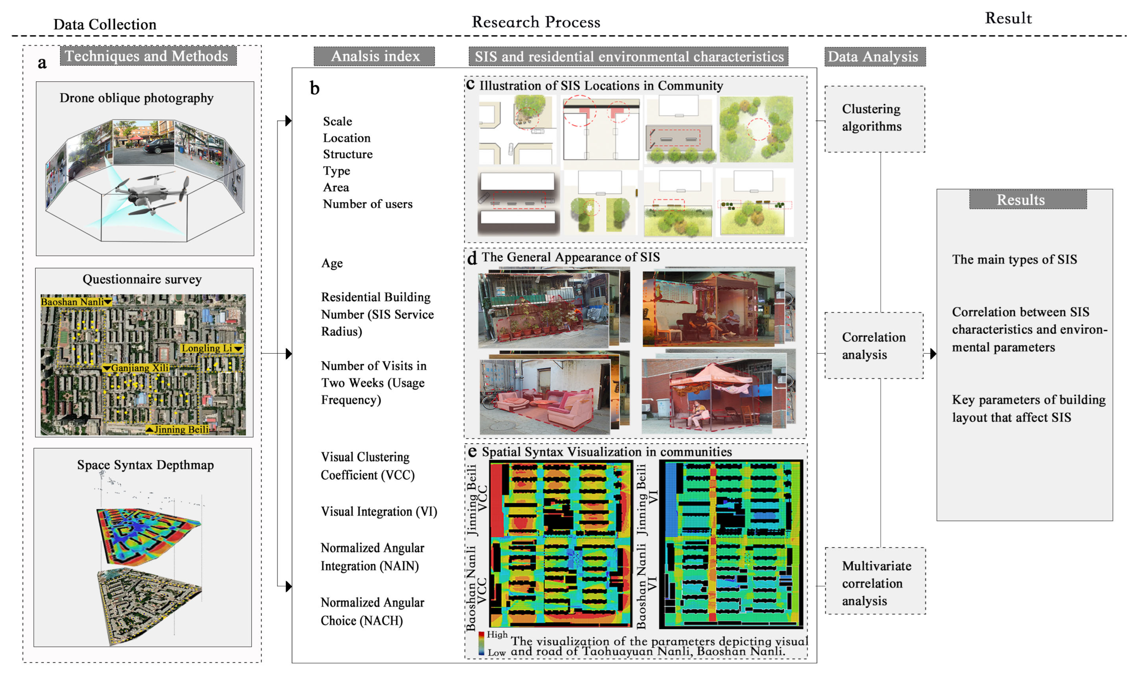
This investigation aims to provide scientific grounds for the redevelopment and strategic formulation of aged communities. We aspire to offer evidence-based directives for renovation or demolition concerning SIS, while also enhancing residents’ quality of life and overarching sense of well-being.

2. Methods

The present study selected five representative old communities in Tianjin City as its primary research subjects and meticulously chose 72 SIS as analysis samples. The selection of these sample spaces was based on the following criteria: (1) The spaces must be autonomously and spontaneously created by residents; (2) relevant structures or spaces must be constructed from recycled materials, old furniture, or other non-traditional building materials, or be annexed to existing buildings; (3) these spaces should cater to the outdoor leisure activities of residents or satisfy daily social needs. We have outlined a detailed workflow for this study (Figure 1).

2.1. Research Area

Tianjin, located to the southeast of Beijing, has undergone rapid economic development. The aging urban area of the city has begun to show problems with outdated public service facilities. Issues have included inadequate infrastructure, old buildings, outdated design, and a lack of effective maintenance strategies [1]. Given this backdrop, numerous SIS have begun to emerge in the old city areas. Consequently, we chose Tianjin as the research context for the deeper insights it could offer in regard to related internal strategies. This offers valuable theoretical and practical insights for other cities regarding urban renewal and aging management.
Tao Huayuan Nanli, Longling Li, Baoshan Nanli, Ganjiang Xili, and Jinning Beili were selected as the core sites for this study (Figure 2). These communities were developed during the 20th century and display significant consistency in terms of their completion period, architectural style, floor area ratio (approximately at 1.7), green space coverage (ranging from 28% to 30%), and nearby public service facilities. Within the context of aging residential areas in Tianjin, these communities can be considered as notably representative, classic, examples.

2.2. Data Collection

2.2.1. Drone-Based SIS Feature Capture

The drone, a DJI Mini 3 PRO, was used to gather data on SIS within residential areas. Equipped with a 1/1.3-inch image sensor, it can record videos at 4 K/60 fps and capture photos with a resolution of up to 48 million pixels. Therefore, when flown at low altitudes, this drone can be used to identify features of residential SIS and to detail information on residents’ activity (such as gender, age group, type of activity, site location details, etc.). Drawing from prior research experience and pre-analysis of data collected in pilot flights for this study, the fieldwork was set from 9 to 20 September 2022, spanning four weekdays and two weekends, and totaling eight days. Specific aerial survey timings were identified as high activity periods: 10:00 a.m., 3:00 p.m., and 7:00 p.m. each day. To ensure the validity of the data acquisition, the optimal flight altitude was tested before the official flights, and a reasonable flight path was charted. A corresponding image data collection scheme was designed, with each flight recording approximately 15 min. After data acquisition, the collected image data underwent cleaning and classification. Research personnel manually extracted two types of data from the images: (1) SIS location, area, type, and structure; and (2) number of users and activity type.
During the data collection process, special measures, such as data blurring and anonymization, were implemented to safeguard the privacy of users. All image data did not contain any sensitive information that could identify individuals. During the drone flights, we strictly adhered to the drone flight management policy of Tianjin and the operational standards stipulated nationally, ensuring the legality and safety of data collection. Lastly, this research received formal approval from the Research Ethics Committee of Tianjin University.

2.2.2. User Insights from Questionnaire

To delve deeper into the characteristics of SIS users, we designed and conducted a detailed questionnaire, recording it during the peak period of daily residential activities (15:00). The questionnaire included the following questions: “What is your age?”, “How many times have you visited this place in the past two weeks?”, “What is your residential building number?”, “What are your main activities in this environment?”, “How do you feel about this environment?” etc. The questions aimed to capture basic information and the preferences of elderly residents regarding the SIS environment. A total of 188 valid questionnaires were retrieved. All subjects gave their informed consent for inclusion before they participated in the study. Based on these data, we further calculated the “average age”, “revisit rate”, and “service radius” of SIS users based on statistical principles as corresponding averages (Table 1).

2.2.3. Space Syntax Modeling of Residential Environments

In the realm of space syntax, Depthmap is recognized as an exceptional computer-aided tool designed specifically for studying the configuration of architectural and urban spaces [40]. Its primary purpose is to provide researchers and practitioners with a platform to quantify and elucidate the interplay between spatial structures and human behaviors, thereby offering solid data support for design decisions and policymaking [41,42]. To build the Depthmap model, we first obtained an accurate CAD map of the community. After an on-site inspection, necessary corrections were made to the community boundaries. Subsequently, we imported the revised base map into the Depthmap software (depthmapX v0.8.0) to establish a convex map and axial map. To ensure the accuracy and completeness of the model data analysis, a buffer zone extending 200 m around the target community was specifically defined.
In our study, we adopted four core parameters from the space syntax framework to quantify the structural layout of residential communities. For instance, in the convex map a visual clustering coefficient (VCC) measures the extent to which the line of sight is blocked at a particular point in space. A higher VCC value represents more obstruction, while a lower value suggests a broader, unobstructed view of its surroundings [36]. Visual integration (VI) gauges how well a specific space is interconnected with the entire system, indicating its “centrality”. Spaces with high VI are more integrated within the layout, while those with low VI are more secluded [36]. In the axial model, we opted for normalized angular integration (NAIN) to measure the integration of a space or path with other spaces or paths when the angle changed. A high NAIN value indicates that fewer angular or directional changes are needed to reach or traverse a particular space or path, making it more intuitive and accessible to people. Lastly, we selected the normalized angular choice (NACH) to quantitatively depict a specific space or path’s selectivity and flow in the entire spatial network. This parameter aids in understanding which spaces or paths play a pivotal connectivity or traffic role in the network.

2.3. Data Analysis

We employed cluster analysis to categorize the SIS information. To explore the relationship between SIS and the community’s layout, we related SIS structural features (area and service radius) and user characteristics (age, number and frequency) to the four parameters (VCC, VI, NACH, NAIN) representing visual and transportation features of the community in Depthmap. In this study, we considered a p-value of <0.05 as statistically significant. The results show a significant association between the number of SIS users and the service radius with Depthmap parameters. Based on these findings, we constructed generalized linear models for both the number of SIS users and the service radius.

3. Results

3.1. Structural Layout Characteristics of Residential Community

Within the spatial layout of the residential community, significant variations are evident in the space syntax parameters across different areas (Figure 3). Initially, the community entrance exhibits a higher VI value, signifying its central and pivotal role in the overall spatial network. Conversely, the VCC value here is relatively low because the entrance experiences minimal visual obstruction, offering good visibility. As one delves deeper into the community roads and activity centers, both NAIN and NACH values escalate, indicating their crucial connective role in the spatial network. The VCC value consequently rises, suggesting that activity centers, due to their complexity and existing obstructions, undergo more visual constraints. In the residential community’s open spaces or subsidiary roads, apart from the increasing VCC suggesting greater visual obstructions, the values of VI, NAIN, and NACH decrease, implying these areas are relatively isolated and not part of the main flow pathways. In the spaces between buildings and small areas in front of them, the VCC value further intensifies as these zones experience substantial visual blockages due to the building structures or other impediments. However, both VI and NAIN values diminish, as these spaces are predominantly utilized by neighboring residents. At the road’s end, due to its encapsulated nature, VCC peaks, indicating maximal visual obstruction. Simultaneously, both NAIN and NACH parameters hit their lowest, as this is not a focal point of movement. This progression of parameters from the community entrance to its various sections aids in understanding how spatial structure profoundly impacts behavioral patterns and interactivity among individuals.

3.2. Transformation and Utilization Methods of SIS

After conducting a field survey of the communities, we organized and classified the ways in which all 72 SIS were transformed and utilized (Figure 4). Firstly, it is worth emphasizing that “air-drying clothes” is the most common type of SIS, accounting for as much as 23.61%. This clearly indicates that, in these residential communities, the space needed for basic living is urgent and widespread. Secondly, “intersection public space” ranked second with a proportion of 15.28%. These data reveal that intersection spaces are not only nodes of traffic flow but are also considered by community residents as multi-functional public spaces. Further, we observed that “placing potted plants in front of the door” and “street sitting space” accounted for 11.11% and 12.50% respectively. Both categories reflect the residents’ demands for an optimization of the living environment and an enhancing of social interaction spaces. Additionally, “front yard greening into private gardens” and “public greening for vegetable planting” accounted for 6.94% and 8.33%, respectively. Although the proportions are relatively low, these data may indicate that residents have a demand for greening the community environment. At the same time, we also noticed that “placing private sundries” and “hidden cluttered space” only accounted for 5.56% and 4.17%, respectively. This reflects the residents’ utilization of abandoned spaces in the communities. Lastly, “fitness space” appeared with a proportion of only 1.39%, which may indicate that in the current space transformation behavior, older residents do not have a strong demand for fitness space.

3.3. Types of SIS

We conducted data clustering of the space syntax parameters of the environments in which SIS are situated, and categorized them into five main types. Furthermore, we found that these types have a corresponding relationship with functions. Therefore, we named them according to their functional characteristics as follows: gardening and planting type, daily living type in front of buildings, leisure and communication type between residential buildings, intersection entertainment and leisure type, and hidden cluttered space type (Table 2; Figure 5). Correspondingly, the average parameter characteristics of each SIS category are detailed in Table 2. In combination with the space syntax parameters and the line-of-sight and roadway features, the detailed characteristics of each SIS type are described below.
Gardening and planting type: This type of SIS is commonly found in areas with high visual exposure and easy supervision, such as public green spaces in front of buildings. Residents place potted plants in public areas or under balconies for public enjoyment. Although this increases the level of visual exposure (VCC = 0.66), its public nature and the beautification effect on the environmental landscape have led to the tacit acceptance of this SIS by pedestrians and community administrators. Its relatively high VI value (VI = 7.64) indicates that these spaces have a certain visual “centrality” within the entire system, meaning that the area is more likely to be noticed by pedestrians.
Daily life type in front of buildings: This type is commonly found in open spaces near the ground floor balconies in front of buildings and is often considered as default private territories. The high VCC value of this area implies that the line of sight is more likely to be obscured (VCC = 0.76), and there is a stronger sense of belonging and privacy. Such environmental conditions lead to many areas being partitioned by fences, often being transformed into spaces serving private daily life needs.
Leisure and communication type between residential buildings: These areas are located in the open spaces between residential buildings, green spaces, and adjacent roads, usually about 5–8 m away from the buildings. Due to the moderate accessibility and permeability of these spaces (NACH = 92.87, NAIN = 1.11), they often serve as micro-scale public leisure and communication spaces between residential neighborhoods. Community residents frequently equip these areas with sofas and coffee tables, place toys, dry clothes, sit leisurely, drink tea, and engage in recreational activities. This environment is often seen as an extension of the residents’ daily lives, serving as a storage area for personal items, a place for leisurely tea drinking, and so on.
Intersection entertainment and leisure type: This SIS is located at intersections in communities. Its high accessibility, high frequency of human traffic (NAIN = 1.20, NACH = 150.18), and wide field of vision (VI = 8.37, VCC = 0.54) make residents more inclined to place seats and tables in these areas, spontaneously transforming them into multifunctional, community-level public communication spaces. These spaces not only provide residents with a perspective by which to monitor outsiders but also compensate for the lack of public communication spaces in old communities.
Hidden cluttered space type: These spaces have a high degree of visual obstruction (VCC = 0.82) and low selectivity and mobility (NACH = 73.21), often lacking a clear function and purpose of use. Due to their geographical location or structural characteristics, these spaces are often overlooked by community members or are inefficiently used, such as areas at the end of roads or visual blind spots, which are often used for piling up debris or gradually becoming unsuitable for use.
In summary, by conducting a cluster analysis of the space syntax parameters of SIS, we found that different types of SIS have different visual and road characteristics, which are closely related to their functions and ways of use. This provides important references that allow us to understand and design more humanized community spaces.

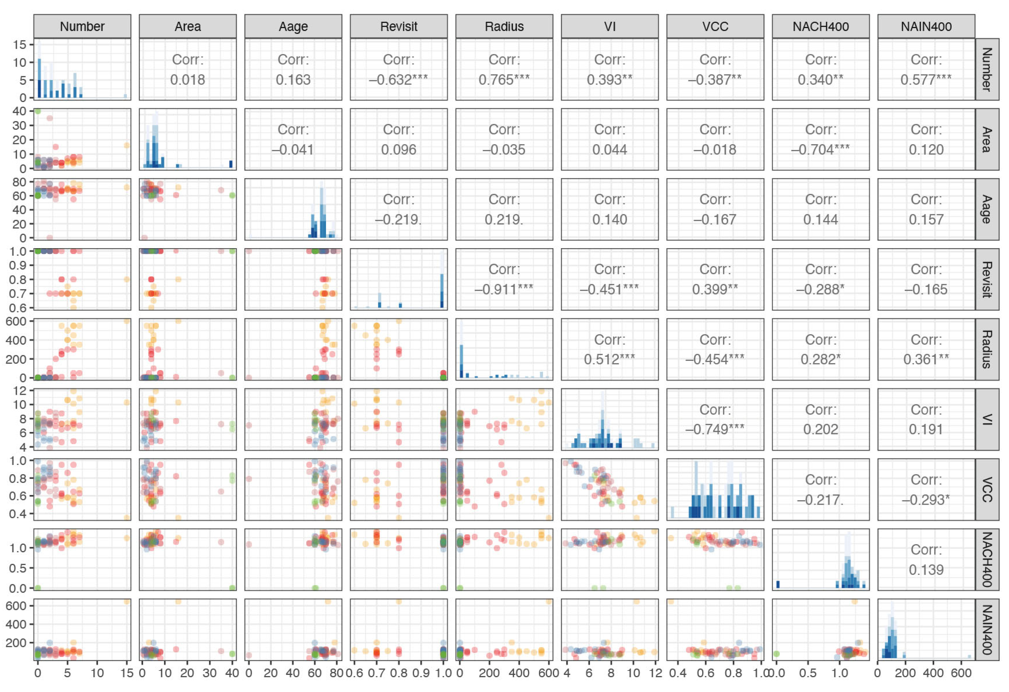
3.4. Correlation between SIS Characteristics and Environmental Parameters

To further understand the association between the key features of SIS and physical environmental parameters in the target community, a correlation analysis was undertaken. The results indicate that these four physical environment parameters (VI, VCC, NACH and NAIN) did not show a significant correlation with the age, user frequency, or area of the SIS (p > 0.05) (Figure 6). However, a significant relationship with the number of users and the service radius was found (p < 0.05).
Additionally, we constructed regression models to analyze key parameters of building layout that affect SIS service characteristics including number of people and radius. Considering this, we further employed a logistic regression model to investigate the potential impact of residential environmental parameters VI(x1), VCC(x2), NACH(x3), and NAIN(x4) on the number of users (y1) and the service radius (y2) of SIS.
A model describing the relationship between environmental parameters and the number of users is illustrated in Table 3 (p = 5.577 × 10⁻⁷, R2 = 0.4614). This indicates that NACH (p < 0.01) and NAIN (p < 0.001) significantly influence the number of users in the SIS. These road accessibility attributes have the most pronounced effect on SIS. However, no significant correlation was identified between VI, VCC, and the number of users (with p-values of 0.1038 and 0.9565, respectively). It can be inferred that the impacts of NAIN and NACH are more critical. When people congregate for activities, roads with high accessibility might function similarly to corridors, offering higher chances of encounters.
Table 3 presents the model that relates environmental parameters to the service radius (p = 5.377 × 10⁻⁵, R2 = 0.3587). The significant variables are VI (p < 0.01) and NAIN (p < 0.01), both of which are positively correlated with y2 and do not exhibit significant interactions. This suggests that the more a space becomes a focal point, the more likely it becomes a destination for residents, thereby attracting inhabitants from greater distances. Spatial position attributes significantly affect the service radius of different SIS. The lack of significance of the visual parameters in the regression analysis may be due to collinearity between VCC and NACH parameters.
In conclusion, NAIN and NACH predominantly determine the number of users in an SIS, while VI and NAIN primarily influence its service radius, together defining the overall service scale of the SIS.

4. Discussion

Although the importance of SIS have been acknowledged, research into their relationship with architectural aspects still lacks a scientific and quantitative methodology. This study aimed to precisely unravel the influence of architectural layout and road traffic features on the SIS. Additionally, we looked into the associated needs of the elderly within older communities using an advanced research strategy. Harnessing drone oblique photography, we comprehensively captured SIS features. Coupled with questionnaire surveys and space syntax analysis. We methodically examined the impact of architectural layout parameters (VCC and VI) as well as accessibility factors (NAIN and NACH) on SIS attributes (e.g., area, service radius, user count). Results indicate that the type and distribution of SIS are largely dictated by the communities’ architecture and road layout. Areas with higher accessibility tend to foster social SIS, while areas with limited visibility or transport convenience gravitate towards private SIS. Moreover, the SIS illuminates the profound needs of the elderly in older communities, encompassing greening, social interaction, and basic living functions.

4.1. Contributions of Research Methodology

In the realm of research on resident behavior in aging neighborhoods, traditional data collection methods have primarily relied on field observation and manual recording. Such methods are not only time-consuming but also inefficient [43]. Despite this, our literature review revealed a gap in research that leverages emerging technologies like drones to explore the SIS in these old residential communities. Moreover, in-depth investigation into the outdoor environmental needs and usage patterns of older residents in formal communities remains conspicuously lacking. This has led to a neglect or obfuscation of the intrinsic logic behind the emergence of SIS, as well as the outdoor living needs of the elderly in research narratives.
Our study innovatively combines drone technology with space syntax theory to provide a new lens for analyzing SIS in aging neighborhoods. This approach not only augments the efficiency of data collection but also unveils new dimensions in understanding outdoor activities and spatial needs of residents in aging communities. We delve into the quantifiable features of SIS within these communities and attempt to explore the potential influence of communities’ layouts on them. By employing a blend of portable drone technology and quantitative surveys, we meticulously document characteristics such as the distribution, scale, and the number of older users of SIS. Cluster analysis helped us identify the predominant types of SIS. Further examination elucidated the correlation between their locations and functions, thereby enriching our understanding of the outdoor activity needs of the elderly. Through spatial syntax analysis, we also uncover the relationships between the distribution of SIS and architectural and road layout features within communities. Additionally, a thorough examination of the social networks and public–private property attributes is reflected by SIS. This provides concrete recommendations for public management and the design of optimization strategies.

4.2. The Influence of Community’s Layout on SIS

In this study, we employed clustering analysis to classify the environmental parameters of SIS, thereby identifying several typical types. It is noteworthy that these typical SIS types, defined by environmental parameters, seem to correlate with specific functionalities. For instance, we observed that the hidden cluttered space type often accompanies a higher VCC value and lower NACH and NAIN parameters. This implies that negative SIS types, including behaviors such as the private occupation of public space and indiscriminate piling of trash and debris, are more likely to occur in places with obstructed sightlines and limited access (e.g., the end of a road, a corner, or a visual blind spot). This observation aligns with findings from studies in other fields. For instance, criminological research has indicated that areas with poor visibility and convoluted paths often lack effective surveillance, becoming hotbeds for irregular behaviors such as crime, uncivil conduct, or illicit trades [44,45].
We observed that SIS for socializing, sitting and chatting are often found in locations with high VI, NACH and NAIN parameters. This type of SIS tends to be located in places that are easily captured visually, such as the center of a community, an intersection, or other important nodes [46]. These geographical sites not only facilitate encounters and exchanges among residents but also allow them to seamlessly join ongoing conversations [47]. Importantly, these SIS are often found near road intersections, ensuring they do not impede regular traffic flow [48]. These findings are consistent with the research results in environmental behavioral psychology, such as the “Edge Preference”, human “Territoriality”, the “Prospect–Refuge Theory”, and “Defensible Space” [49,50]. Previous studies have mentioned that individuals prefer places with certain edge characteristics, supportive elements, or concave spaces for stopping and conversing in public spaces [44]. This inclination seeks to meet the psychological needs of “Observation and Being Observed”, ensuring psychological comfort in public areas [46]. Similar observations have been made in studies surveying squares, parks, and communities [51,52,53,54,55]. As Gehl has pointed out, there is a close correlation between human behaviors in public spaces and their physical environments [44]. This often manifests as supporting effects, edge effects, and semi-shading effects [46]. These factors collectively offer individuals a sense of security, shelter, and fulfillment in observing others during their leisure time [56]. Based on these observations, it is also easy to summarize the three main outdoor needs of the elderly reflected by the SIS: basic living needs, social needs, and greenery needs.

4.3. Sociological Insights and Design Recommendations for SIS

The presence of SIS may suggest a hierarchical nature of social circles for the elderly within the community. According to existing research, specific architectural layout parameters have discernible impacts on the scale of SIS service, such as the number of people involved and the service radius. Specifically, open and easily accessible spaces tend to cater to a broader range of community residents, while secluded and private areas primarily address the needs of residents within close proximity [49,57]. As spatial positioning transitions from main community roads to individual buildings, and further to private spaces in front of residences, we can observe a diminishing trend in the service scale, user count, and service radius of SIS. Concurrently, the familiarity and closeness among users in these spaces show an upward trajectory. Interestingly, such a hierarchical structure of spontaneous spaces is not limited to residential areas alone. Indeed, similar trends have been observed in other urban and rural landscapes, such as spontaneous commercial activities and markets [58,59]. These activities closely correlate with specific urban structural parameters, such as road and building layouts, thus influencing the density and distribution of commercial activities [36].
This study unveils how SIS redefine the boundaries between public and private spaces in communities. Our findings indicate that architectural layout parameters did not significantly impact the area of an SIS. This aptly reflects the way in which an SIS emerges as a psychological tussle between residents’ informal behaviors and public oversight, possessing a temporary nature susceptible to regulatory removal [13,60]. Influenced by oversight, SIS are often structured as low-cost infrastructures (e.g., shading facilities and repurposed furniture seating). In line with observations from studies on informal commerce and residential communities, these non-standard behaviors often materialize in time, space, and areas typically overlooked by oversight mechanisms [36]. Crucially, even though these SIS do not directly challenge regulatory authority, due to the variability in oversight intensity with location, they reshape the delineation between public and private realms [60]. For instance, SIS at intersections manifest strong public characteristics. In contrast, those located within residential areas or between buildings resemble semi-public spaces, and spaces like balconies transform into purely private domains. This is consistent with psychological perceptions of public versus private spaces; the former typically comes with more restrictions, while the latter offers residents greater freedom [57,58,61,62]. Hence, it can be concluded that architectural and road layouts not only influence the distribution and functionality of SIS but also redefine, based on their environmental psychological characteristics (i.e., default psychological presets for using specific areas), the public–private attributes of the community environment in both residents’ minds and practical use.
Based on our research findings, the relationship between architectural layout and SIS provides clear guidance for urban planning, especially when addressing the needs of elderly communities. Some of the recommendations based on our research findings include:
(1)
Maximizing Accessibility and Visibility: To promote social SIS, designers should create open layouts, wider pathways, and more public spaces while minimizing dead ends. Reducing blind spots and enhancing visibility deters undesirable behaviors.
(2)
Providing Green Planting Spaces for the Elderly: Urban planners should allocate areas in elderly communities for pocket gardens and community gardens, catering to their planting needs.
(3)
Flexible, Participatory Design to Meet Social Needs: To cater to the diverse social needs of the elderly, spatial design should be flexible. For example, modular seating or movable shading structures can be integrated into public spaces. Additionally, it is encouraged to involve community residents, especially the elderly, in the design process. Their insights and life experiences can guide context-specific and user-friendly designs.
(4)
Protecting and Strengthening Public–Private Boundaries: Recognizing how SIS redefines boundaries, urban design should strive for a balance. It should introduce personalized measures for defining areas to meet residents’ psychological needs while respecting public spaces to provide a sense of belonging.
(5)
Promoting Positive SIS: Managers should avoid attempting to eliminate or regulate all SIS. Urban designers should recognize their societal value and integrate the concept of spontaneous and organic SIS effectively into formalized spaces.

4.4. Limitation

Our research meticulously delves into the characteristics of residential neighborhoods and the emergence of SIS. However, an inherent limitation is our concentrated focus, which might not encompass a broader analysis of the overall urban planning framework, particularly the distribution and spatial configuration of public spaces [63]. Such a limitation gives rise to imperative questions: How might expansive public spaces within residential communities influence the incidence of SIS? And when communities are replete with structured green amenities, does the inclination toward spontaneous planting diminish? [64]. Addressing these nuances is essential to better understand residents’ spatial behaviors and the relationship between public spaces and community dynamics. Furthermore, while our study serves as a reflective representation of Tianjin’s long-standing residential communities, spotlighting five specific areas, the somewhat confined sample might not capture the entirety of urban dynamics. Hence, extrapolating our findings to recently established districts in burgeoning cities or cities at diverse economic and developmental junctures might be challenging, especially those with unique policy and cultural imprints. Such varied urban environments could exhibit nuances not considered in our current investigation.
Nevertheless, the challenges we encountered underscore a silver lining: our research methodology showcases remarkable scalability. Its inherent versatility makes it apt for expansive, large-scale urban examinations. Future studies, therefore, stand to gain by leveraging our methodological framework across a broader spectrum and in diverse cultural terrains, ensuring a more comprehensive grasp of urban interplays and the intricacies of SIS.

5. Conclusions

In summary, this research aimed to delve into the influence of architectural and road layouts in older communities on SIS and the needs of the elderly, employing drone photography, questionnaire surveys, and space syntax analysis. The findings indicate that the architecture and road configurations significantly shaped the distribution and characteristics of SIS: areas with high accessibility lean towards social SIS, while those with low accessibility are more prone to private SIS. Furthermore, the SIS sheds light on the urgent requirements of the elderly for greenery, socialization, and basic living functionalities.
Additionally, an intriguing aspect that was discovered was the predominance and importance of stationary activities within these older communities. Stationary activities play a significant role in the lives of the elderly, offering them opportunities for relaxation, engagement, and socialization. Areas with ample provisions for stationary activities, such as benches, gardens, and recreational zones, were found to be more favored among the elderly, further highlighting their significance.
Given the current trend of urban aging and micro-renovation policies, this study recommends that governments adopt a progressive SIS renewal strategy instead of straightforward demolitions, emphasizing the incorporation of residents’ experiences and needs to ensure the renewal aligns seamlessly with everyday life. This research offers a scientific foundation for the renovation of outdoor environments in older communities. We suggest future research broadens its scope and explores the application of technology in urban planning, thereby fostering sustainable urban development and a harmonious coexistence between humans and their surroundings.

Author Contributions

Conceptualization, Ran Zhang and Ping Shu; methodology, Ran Zhang and Lei Cao; software, Ran Zhang, Lei Cao and Yiqing Liu; validation, Ran Zhang and Yiqing Liu; formal analysis, Lei Cao and Yiqing Liu; investigation, Ru Guo and Junjie Luo; resources, Ru Guo and Junjie Luo; data curation, Junjie Luo; writing—original draft preparation, Ran Zhang; writing—review and editing, Ran Zhang and Lei Cao; visualization, Ru Guo; supervision, Ping Shu; project administration, Ping Shu; funding acquisition, Ping Shu. All authors have read and agreed to the published version of the manuscript.

Funding

This study is financially supported by the National Natural Science Foundation of China (52078178).

Conflicts of Interest

The authors declare no conflict of interest.

References

  1. Sun, X.; Wang, L.; Wang, F.; Soltani, S. Behaviors of Seniors and Impact of Spatial Form in Small-Scale Public Spaces in Chinese Old City Zones. Cities 2020, 107, 102894. [Google Scholar] [CrossRef]
  2. Besser, L.M. Individual and Neighborhood Characteristics Associated with Neighborhood Walking among US Older Adults. Prev. Med. Rep. 2021, 21, 101291. [Google Scholar] [CrossRef] [PubMed]
  3. Ma, X.; Ma, C.; Wu, C.; Xi, Y.; Yang, R.; Peng, N.; Zhang, C.; Ren, F. Measuring Human Perceptions of Streetscapes to Better Inform Urban Renewal: A Perspective of Scene Semantic Parsing. Cities 2021, 110, 103086. [Google Scholar] [CrossRef]
  4. Qiao, Z.; Liu, L.; Qin, Y.; Xu, X.; Wang, B.; Liu, Z. The Impact of Urban Renewal on Land Surface Temperature Changes: A Case Study in the Main City of Guangzhou, China. Remote Sens. 2020, 12, 794. [Google Scholar] [CrossRef]
  5. Zhuang, T.; Qian, Q.K.; Visscher, H.J.; Elsinga, M.G.; Wu, W. The Role of Stakeholders and Their Participation Network in Decision-Making of Urban Renewal in China: The Case of Chongqing. Cities 2019, 92, 47–58. [Google Scholar] [CrossRef]
  6. World Urbanization Prospects—Population Division-United Nations. Available online: https://population.un.org/wup/ (accessed on 25 June 2023).
  7. Paquet, C.; Whitehead, J.; Shah, R.; Adams, A.M.; Dooley, D.; Spreng, R.N.; Aunio, A.-L.; Dubé, L. Social Prescription Interventions Addressing Social Isolation and Loneliness in Older Adults: Meta-Review Integrating On-the-Ground Resources. J. Med. Internet Res. 2023, 25, e40213. [Google Scholar] [CrossRef] [PubMed]
  8. Kamalipour, H.; Dovey, K. Incremental Production of Urban Space: A Typology of Informal Design. Habitat Int. 2020, 98, 102133. [Google Scholar] [CrossRef]
  9. Soyinka, O.; Adenle, Y.A.; Abdul-Rahman, M. Urban Informality and Sustainable Design of Public Space Facilities: A Case Study of Hong Kong SAR of China in 2018. Environ. Dev. Sustain. 2021, 23, 16560–16587. [Google Scholar] [CrossRef]
  10. Sverdlik, A. Ill-Health and Poverty: A Literature Review on Health in Informal Settlements. Environ. Urban. 2011, 23, 123–155. [Google Scholar] [CrossRef]
  11. Dovey, K.; King, R. Forms of Informality: Morphology and Visibility of Informal Settlements. Built Environ. 2011, 37, 11–29. [Google Scholar] [CrossRef]
  12. Castells, M. The City and the Grassroots: A Cross-Cultural Theory of Urban Social Movements, 1st ed.; University of California Press: Berkeley, CA, USA; Los Angeles, CA, USA, 1983. [Google Scholar]
  13. Roy, A.; AlSayyad, N. Urban Informality: Transnational Perspectives from the Middle East, Latin America, and South Asia, 1st ed.; Lexington Books: Lanham, MD, USA, 2004. [Google Scholar]
  14. Bromley, R. Street Vending and Public Policy: A Global Review. Int. J. Sociol. Soc. Policy 2000, 20, 1–28. [Google Scholar] [CrossRef]
  15. Donovan, M.G. Informal Cities and the Contestation of Public Space: The Case of Bogotá’s Street Vendors, 1988–2003. Urban Stud. 2008, 45, 29–51. [Google Scholar] [CrossRef]
  16. Ulyssea, G. Firms, Informality, and Development: Theory and Evidence from Brazil. Am. Econ. Rev. 2018, 108, 2015–2047. [Google Scholar] [CrossRef]
  17. Okyere, S.A.; Diko, S.K.; Hiraoka, M.; Kita, M. An Urban “Mixity”: Spatial Dynamics of Social Interactions and Human Behaviors in the Abese Informal Quarter of La Dadekotopon, Ghana. Urban Sci. 2017, 1, 13. [Google Scholar] [CrossRef]
  18. Dovey, K.; van Oostrum, M.; Chatterjee, I.; Shafique, T. Towards a Morphogenesis of Informal Settlements. Habitat Int. 2020, 104, 102240. [Google Scholar] [CrossRef]
  19. Chiodelli, F.; Moroni, S. The Complex Nexus between Informality and the Law: Reconsidering Unauthorised Settlements in Light of the Concept of Nomotropism. Geoforum 2014, 51, 161–168. [Google Scholar] [CrossRef]
  20. Yiftachel, O. Epilogue-from “Gray Space” to Equal “Metrozenship”? Reflections On Urban Citizenship. Int. J. Urban Reg. Res. 2015, 39, 726–737. [Google Scholar] [CrossRef]
  21. Zhang, B.; Guo, W.; Xing, Z.; Zhou, R. Current Situation and Sustainable Renewal Strategies of Public Space in Chinese Old Communities. Sustainability 2022, 14, 6723. [Google Scholar] [CrossRef]
  22. Li, J.; Wang, F.; Wuzhati, S.; Wen, B. Urban or Village Residents? A Case Study of the Spontaneous Space Transformation of the Forced Upstairs Farmers’ Community in Beijing. Habitat Int. 2016, 56, 136–146. [Google Scholar] [CrossRef]
  23. Xing, Z.; Guo, W.; Liu, J.; Xu, S. Toward the Sustainable Development of the Old Community: Proposing a Conceptual Framework Based on Meaning Change for Space Redesign of Old Communities and Conducting Design Practices. Sustainability 2022, 14, 4755. [Google Scholar] [CrossRef]
  24. Guo, S.; Song, C.; Pei, T.; Liu, Y.; Ma, T.; Du, Y.; Chen, J.; Fan, Z.; Tang, X.; Peng, Y.; et al. Accessibility to Urban Parks for Elderly Residents: Perspectives from Mobile Phone Data. Landsc. Urban Plan. 2019, 191, 103642. [Google Scholar] [CrossRef]
  25. Kemperman, A.; Timmermans, H. Green Spaces in the Direct Living Environment and Social Contacts of the Aging Population. Landsc. Urban Plan. 2014, 129, 44–54. [Google Scholar] [CrossRef]
  26. Wen, C.; Albert, C.; Von Haaren, C. The Elderly in Green Spaces: Exploring Requirements and Preferences Concerning Nature-Based Recreation. Sustain. Cities Soc. 2018, 38, 582–593. [Google Scholar] [CrossRef]
  27. Yung, E.H.K.; Wang, S.; Chau, C. Thermal Perceptions of the Elderly, Use Patterns and Satisfaction with Open Space. Landsc. Urban Plan. 2019, 185, 44–60. [Google Scholar] [CrossRef]
  28. Xiao, Y.; Wang, D.; Fang, J. Exploring the Disparities in Park Access through Mobile Phone Data: Evidence from Shanghai, China. Landsc. Urban Plan. 2019, 181, 80–91. [Google Scholar] [CrossRef]
  29. Heikinheimo, V.; Tenkanen, H.; Bergroth, C.; Järv, O.; Hiippala, T.; Toivonen, T. Understanding the Use of Urban Green Spaces from User-Generated Geographic Information. Landsc. Urban Plan. 2020, 201, 103845. [Google Scholar] [CrossRef]
  30. Donahue, M.L.; Keeler, B.L.; Wood, S.A.; Fisher, D.M.; Hamstead, Z.A.; McPhearson, T. Using Social Media to Understand Drivers of Urban Park Visitation in the Twin Cities, MN. Landsc. Urban Plan. 2018, 175, 1–10. [Google Scholar] [CrossRef]
  31. Hamstead, Z.A.; Fisher, D.; Ilieva, R.T.; Wood, S.A.; McPhearson, T.; Kremer, P. Geolocated Social Media as a Rapid Indicator of Park Visitation and Equitable Park Access. Comput. Environ. Urban Syst. 2018, 72, 38–50. [Google Scholar] [CrossRef]
  32. Alivand, M.; Hochmair, H.H. Spatiotemporal Analysis of Photo Contribution Patterns to Panoramio and Flickr. Cartogr. Geogr. Inf. Sci. 2016, 44, 170–184. [Google Scholar] [CrossRef]
  33. Delavarpour, N.; Koparan, C.; Nowatzki, J.; Bajwa, S.; Sun, X. A Technical Study on UAV Characteristics for Precision Agriculture Applications and Associated Practical Challenges. Remote Sens. 2021, 13, 1204. [Google Scholar] [CrossRef]
  34. Luo, J.; Zhao, T.; Cao, L.; Biljecki, F. Semantic Riverscapes: Perception and Evaluation of Linear Landscapes from Oblique Imagery Using Computer Vision. Landsc. Urban Plan. 2022, 228, 104569. [Google Scholar] [CrossRef]
  35. Park, K.; Ewing, R. The Usability of Unmanned Aerial Vehicles (UAVs) for Measuring Park-Based Physical Activity. Landsc. Urban Plan. 2017, 167, 157–164. [Google Scholar] [CrossRef]
  36. Hillier, B. Space is the Machine: A Configurational Theory of Architecture; Space Syntax: London, UK, 2007. [Google Scholar]
  37. Chen, S.; Knöll, M. Refugee Children’s Access to Play in Meso-Environments: A Novel Approach Using Space Syntax and GIS. Buildings 2023, 13, 111. [Google Scholar] [CrossRef]
  38. Sultan Qurraie, S.; Mansouri, S.A.; Singery, M. Landscape Syntax, Landscape Assessment Using Landscape Approach Indices. MANZAR 2023, 15, 20–27. [Google Scholar]
  39. Istiani, N.F.F.; Alkadri, M.F.; van Nes, A.; Susanto, D. Investigating the Spatial Network of Playgrounds during COVID-19 Based on a Space Syntax Analysis Case Study: 10 Playgrounds in Delft, the Netherlands. Cogent Soc. Sci. 2023, 9, 2163754. [Google Scholar] [CrossRef]
  40. McCahill, C.; Garrick, N.W. The Applicability of Space Syntax to Bicycle Facility Planning. Transp. Res. Rec. 2008, 2074, 46–51. [Google Scholar] [CrossRef]
  41. Hillier, W.R.G. What are cities for? and how does it relate to their spatial form? J. Space Syntax. 2016, 6, 199–212. [Google Scholar]
  42. Hillier, B. A Theory of the City as Object: Or, How Spatial Laws Mediate the Social Construction of Urban Space. Urban Des. Int. 2002, 7, 153–179. [Google Scholar] [CrossRef]
  43. Marquet, O.; Hipp, J.A.; Alberico, C.; Huang, J.-H.; Fry, D.; Mazak, E.; Lovasi, G.S.; Floyd, M.F. Use of SOPARC to Assess Physical Activity in Parks: Do Race/Ethnicity, Contextual Conditions, and Settings of the Target Area, Affect Reliability? BMC Public Health 2019, 19, 1730. [Google Scholar] [CrossRef]
  44. Gehl, J. Life between Buildings: Using Public Space; Island Press: Washington, DC, USA, 2011. [Google Scholar]
  45. Cozens, P.M.; Saville, G.; Hillier, D. Crime Prevention through Environmental Design (CPTED): A Review and Modern Bibliography. Prop. Manag. 2005, 23, 328–356. [Google Scholar] [CrossRef]
  46. Can, I.; Heath, T. In-between spaces and social interaction: A morphological analysis of Izmir using space syntax. J. Hous. Built Environ. 2016, 31, 31–49. [Google Scholar] [CrossRef]
  47. Pan, M.; Shen, Y.; Jiang, Q.; Zhou, Q.; Li, Y. Reshaping Publicness: Research on Correlation between Public Participation and Spatial Form in Urban Space Based on Space Syntax—A Case Study on Nanjing Xinjiekou. Buildings 2022, 12, 1492. [Google Scholar] [CrossRef]
  48. Li, W.; Chen, M.; Yao, N.; Luo, Z.; Jiao, Y. Spatial-Temporalevolution of Roadway Layout System from a Space Syntax Perspective. Tunnell. Undergr. Space Technol. 2023, 135, 105038. [Google Scholar] [CrossRef]
  49. Newman, O. Defensible Space; Crime Prevention through Urban Design; Macmillan: New York, NY, USA, 1972. [Google Scholar]
  50. Mawby, R.I. Defensible Space: A Theoretical and Empirical Appraisal. Urban Stud. 1977, 14, 169–179. [Google Scholar] [CrossRef]
  51. Mouratidis, K.; Poortinga, W. Built Environment, Urban Vitality and Social Cohesion: Do Vibrant Neighborhoods Foster Strong Communities? Landsc. Urban Plan. 2020, 204, 103951. [Google Scholar] [CrossRef]
  52. Xia, C.; Yeh, A.G.-O.; Zhang, A. Analyzing Spatial Relationships between Urban Land Use Intensity and Urban Vitality at Street Block Level: A Case Study of Five Chinese Megacities. Landsc. Urban Plan. 2020, 193, 103669. [Google Scholar] [CrossRef]
  53. Lai, D.; Lian, Z.; Liu, W.; Guo, C.; Liu, W.; Liu, K.; Chen, Q. A Comprehensive Review of Thermal Comfort Studies in Urban Open Spaces. Sci. Total Environ. 2020, 742, 140092. [Google Scholar] [CrossRef]
  54. Torku, A.; Chan, A.P.C.; Yung, E.H.K.; Seo, J. The Influence of Urban Visuospatial Configuration on Older Adults’ Stress: A Wearable Physiological-Perceived Stress Sensing and Data Mining Based-Approach. Build. Environ. 2021, 206, 108298. [Google Scholar] [CrossRef]
  55. Kohn, M. Brave New Neighborhoods: The Privatization of Public Space; Routledge: New York, NY, USA, 2004. [Google Scholar]
  56. Li, X.; Li, Z.; Jia, T.; Yan, P.; Wang, D.; Liu, G. The sense of community revisited in Hankow, China: Combining the impacts of perceptual factors and built environment attributes. Cities 2021, 111, 103108. [Google Scholar] [CrossRef]
  57. Alexander, C. A Pattern Language: Towns, Buildings, Construction; Oxford University Press: Oxford, UK, 2018. [Google Scholar]
  58. Lynch, K. The Image of the City; MIT Press: Cambridge, MA, USA, 1964. [Google Scholar]
  59. Jacobs, J. The Death and Life of Great American Cities; Vintage Books: New York, NY, USA, 2016. [Google Scholar]
  60. Tyler, T.R. Why People Obey the Law; Princeton University Press: Princeton, NJ, USA, 2006. [Google Scholar]
  61. Altman, I. The Environment and Social Behavior: Privacy, Personal Space, Territory, Crowding; Brooks/Cole Pub. Co.: Monterey, CA, USA, 1975. [Google Scholar]
  62. Gehl, J. Cities for People; Island Press: Washington, DC, USA, 2010. [Google Scholar]
  63. Zhang, W.; Chong, Z.; Li, X.; Nie, G. Spatial Patterns and Determinant Factors of Population Flow Networks in China: Analysis on Tencent Location Big Data. Cities 2020, 99, 102640. [Google Scholar] [CrossRef]
  64. Hillier, B. Studying Cities to Learn about Minds: Some Possible Implications of Space Syntax for Spatial Cognition. Environ. Plan. B Plan. Des. 2012, 39, 12–32. [Google Scholar] [CrossRef]
Figure 1. An overview of the workflow of this study. (a) The means of data acquisition. (b) The primary indicators of data analysis. (c) The location of SIS in the residential area. (d) The general appearance of SIS. (e) The visualization results of spatial syntax parameters of the residential environment.
Ijgi 12 00452 g001
Figure 2. Study area and the distribution of SIS.
Ijgi 12 00452 g002
Figure 3. The convex map and axial map of the community constructed based on spatial syntax. The visualization of four parameters, VCC, VI, NACH, and NAIN, is demonstrated using Depthmap. Warm colors represent high values, while cool colors reflect low values.
Ijgi 12 00452 g003
Figure 4. Bar chart of the transformation and utilization methods of SIS.
Ijgi 12 00452 g004
Figure 5. Pictures during field observation in residential areas.
Ijgi 12 00452 g005
Figure 6. The correlation analysis between the characteristics of SIS and the parameters of VI, VCC, NACH, and NAIN. * p < 0.05; ** p < 0.01; *** p < 0.001.
Ijgi 12 00452 g006
Table 1. The detailed calculation methods and metric definitions for the gathering characteristics of SIS users.
SIS FeaturesImportant ParametersCalculation Method/Description
Basic featuresAreas = area of each SIS
LocationLatitude and longitude of each SIS
StructurePhysical structure of each SIS (e.g., sunshade, fence, seats, sofas, etc.)
TypeClassification of SIS based on function and usage (e.g., entertainment area, green plant area, basic living area, etc.)
Usage characteristicsAverage ageAverage age = 1 = 0 n a i n
ai: the age of each user
n: total number of users in each SIS
Number of usersNumber of Users = 1 = 0 k p i k
pi: the number of people during each survey
k: the order of drone shooting
Service scale featuresAverage usage FrequencyAverage usage frequency = 1 = 0 n f i n
fi: a user’s frequency of visits in a SIS during past 2 weeks
n: total number of users in each SIS
Average service radiusAverage service radius = i = 0 n r i n
ri: the distance of each user
n: total number of users in each SIS
Table 2. The type of SIS and parameter range classification table.
The Type of SISThe Service Radius (m)The Number of UsersMean Value of Parameters for Each Type
VIVCCNAINNACH
Gardening and planting2.710.837.640.661.13104.74
Daily living type in front of buildings4.721.286.960.761.1393.75
Leisure and communication type between residential buildings133.214.107.130.691.1192.87
Intersection entertainment and leisure type427.276.108.370.541.20150.18
Hidden cluttered space type005.870.820.5873.21
Table 3. Multilevel regression of the impact of environmental parameters on the number of users and service radius of SIS.
ConstantVI (x1) VCC (x2)NACH (x3)NAIN (x4)
Number of users (y1)−8.459 × 10−172.478 × 10⁻¹−8.430 × 10−32.189 × 10−1 *4.965 × 10−1 **
Service radius (y2)−5.495 × 10−163.929 × 10⁻¹−5.294 × 10−21.561 × 10−12.485 × 10⁻¹ *
* p < 0.05; ** p < 0.01.
Disclaimer/Publisher’s Note: The statements, opinions and data contained in all publications are solely those of the individual author(s) and contributor(s) and not of MDPI and/or the editor(s). MDPI and/or the editor(s) disclaim responsibility for any injury to people or property resulting from any ideas, methods, instructions or products referred to in the content.

