
Wildland Fires in the Czech Republic—Review of Data Spanning 20 Years


Ministry of Interior, Directorate General of Fire and Rescue Service of the Czech Republic, Kloknerova 26, P.O. Box 69, 148 01 Prague, Czech Republic
ISPRS Int. J. Geo-Inf. 2022, 11(5), 289; https://doi.org/10.3390/ijgi11050289
Submission received: 30 December 2021
/
Revised: 7 March 2022
/
Accepted: 15 March 2022
/
Published: 29 April 2022
(This article belongs to the Special Issue GIScience for Risk Management in Big Data Era)
Abstract
:The following article deals with more than 20 years of historical wildland fire data from the Czech Republic, logged in the databases of the operational centers of the Fire and Rescue Service of the Czech Republic (FRS of CR). First, the definition of the term wildland fire is introduced. After that, the locations of wildland fires are discussed, from the point of view of their introduction into the information systems. Next, as the FRS of CR is organized on a regional basis, the number of wildland fires is analyzed regionally. On the basis of this analysis, some advice concerning the preparation for and prevention of wildland fires is provided—for example, focusing fire prevention campaigns in regions where the wildland fire incidence per inhabitant is high, planning aerial firefighting asset coverage with respect to the occurrence of wildland fires, or deploying the necessary fire suppression equipment according to the dominant wildland fire fuel type. Finally, questions concerning the homogeneity of groups of wildland fires which naturally emerge during the process of selection from the emergency database are discussed.
1. Introduction
This article considers data collected by the operational centers of the Fire and Rescue Service of the Czech Republic (FRS of CR) for analytical purposes in an attempt to answer the question of whether data collected for merely evidential purposes can be used for statistical analysis. For this reason, the quality of the data is examined in this article, especially the variation in data quality over time. An overview of the time course of selected attributes (e.g., the fuel type involved in wildland fires or the number of fires in various regions) is also provided, which may be interesting from a fire prevention and suppression point of view. The results of the introductory data survey are then applied in an attempt to address real problems connected to firefighting, such as focusing fire prevention campaigns in regions where the wildland fire incidence per inhabitant is high, planning aerial firefighting asset coverage with respect to the wildland fire occurrence, or deploying the necessary fire suppression equipment according to the dominant wildland fire fuel type.
The statistical efforts of the FRS of CR date back through its long history. However, to date, these efforts have mainly been focused on the statistical evidence of emergencies, damages, and saved values, as well as basic exploratory data analysis, due to its importance for resource allocation by the FRS of CR.
At present, existing statistical methods (both spatial and non-spatial), software libraries, and tools provide the possibility of obtaining deeper insight into collected data, allowing us to obtain an understanding of the mechanisms leading to emergencies (e.g., wildland fires), as well as their occurrence in time and space [1,2,3,4]. Understanding these mechanisms can substantially improve the prevention of emergencies and the distribution of assets for their mitigation, further enhancing the services provided by emergency response agents, such as the FRS of CR, to the citizens of the Czech Republic. Thus, this effort follows up the work of predecessors in this field and further develops these activities in order to enhance the services provided by the FRS of CR.
Advanced statistical methods can provide very interesting results; unfortunately, however, such results seldom find their way into the daily praxis of the everyday life of organizations and personnel directly responsible for carrying out emergency management duties. Moreover, it is generally the case that more sophisticated results are more difficult to apply, as they are more difficult to understand. Considering these facts, in this article, a less-advanced approach to analyzing wildland fire data is applied: instead of using advanced methods, the findings obtained from basic reporting on fire trends are transferred into recommendations that are easily applicable in the daily praxis of emergency management.
Wildland fires was selected as a pilot area for broader and deeper application of the advanced statistical methods used by the FRS of CR, which follows the line of exploratory data analysis. The main reason for this selection is that wildland fires pose a substantial danger to humans and nature. Moreover, wildland fires may occur in places in which they were rare in the past, or have become more severe due to climate change. As a result, the effective management and prevention of these events is highly desirable and demand a high level of preparedness. However, decisions leading to a high level of readiness are hardly ever possible without the proper analysis of historical wildland fire data.
Historical data describing emergencies are precious sources of information, often obtained through tremendous pain and human suffering. Disregarding their analysis in the decision process can lead to the misuse of precious resources or even the loss of human lives.
The general concept of a wildland fire includes various categories of fires, which behave differently in time and space. However, from a practical point of view, it is beneficial to define wildland fires as broadly as possible. The reason for such an approach is that these fires usually share some common characteristics, and the same approaches and resources are used for their management. Further, it is also necessary to mention that some fires can very rapidly switch from one type to another.
2. Wildland Fire Definition
Almost all people intuitively know what a wildland fire is. However, the variety of wildland fire definitions suggests that the term wildland fire must be precisely defined, especially when statistical analysis of this subject is to be carried out. For example, comparing various studies on wildland fires can be difficult if the kinds of emergencies included in the study are not precisely specified. Considering this fact, we propose the definition of wildland fires based on the group of object types on which the fires occur. A fire is considered a wildland fire when the main object involved belongs to a pre-defined group. Such a definition of wildland fire gives us precise guidelines for emergencies to be included in a group of wildland fires. This approach is motivated by the fact that, at the beginning of each analysis, the group of wildland fires is selected from a data storage system (usually a relational database or MS Excel file) according to a precisely defined (SQL) query.
Many definitions for wildland fires can be found in the various existing resources. The following can be mentioned as an example:
- Any non-structure fire, other than prescribed fires, that occurs in the wildland [5];
- An unplanned fire—including unauthorized human-caused fires-occurring on forest or range lands, burning forest vegetation, grass, brush, scrub, or peatlands—or a prescribed fire, set under regulation, which spreads beyond the area authorized for burning [8];
- A wildfire, bushfire, wildland fire, or rural fire is an unplanned, unwanted, and uncontrolled fire in an area of combustible vegetation starting in rural areas and urban areas. Depending on the type of vegetation present, a wildfire can also be classified more specifically as a forest fire, brush fire, bushfire (in Australia), desert fire, grass fire, hill fire, peat fire, prairie fire, vegetation fire, or veld fire. Many organizations consider wildfire to denote an unplanned and unwanted fire, while wildland fire is a broader term that includes prescribed fires as well as wildland fire use (WFU; these are also called monitored response fires) [9].
After deep internal discussion based on the definitions mentioned above, the criteria were defined to include the fires into a group of wildland fires in the area of the Czech Republic. First, from the database of all emergencies at the Operational and Information Center of the FRS of CR, the fires in the area of the Czech Republic were selected (due to cross-border cooperation, the FRS of CR is also involved in the management of emergencies outside the Czech Republic). After that, the possible wildland fire sites were selected using the standard classification scheme of objects on which emergencies can occur. In the case of wildland fire, the object on which the wildland fire occurs usually means the primary fuel consumed by the wildland fire. However, in the case of other fire types (e.g., house fires or transport vehicle fires), the situation is more complicated. Therefore, the objects on which wildland fires occur were further grouped into three categories (i.e., field, forest, and other wildland), according to the similarity of the primary fuel type consumed by the wildland fire. The main aim of the grouping was to make the comparison of the time course of various types of wildland fires more understandable. An emergency was included in the set of wildland fires if it took place at the possible site of a wildland fire.
To make the selection easily understandable, the selected sites were further grouped into three groups. The following sites were considered as places of wildland fires:
- Field.
- (a)
- Grain in the field.
- (b)
- Straw in the field and stubble.
- (c)
- Unharvested field, mown grain in the field.
- (d)
- Other object.
- Forest.
- (a)
- Mature coniferous forest.
- (b)
- Mature deciduous forest.
- (c)
- Mature mixed forest.
- (d)
- Grass cover, tree nursery, needles, leaves, peat.
- (e)
- Young forest (stump, low forest vegetation, dwarf mountain pine).
- (f)
- Logging.
- (g)
- Other forest land.
- (h)
- Other land.
- Other wildland.
- (a)
- Balk, railway embankments.
- (b)
- Orchards, gardens and lonely trees, greenhouses, yards, beekeeping and small livestock.
- (c)
- Reclamation (outside the forest).
- (d)
- Agricultural uncultivated areas, meadows.
- (e)
- Parks, solitary trees, and shrubs.
3. History of Wildland Fire Location Logging
The current state of information technology enables logging of the precise location of an emergency, which was not previously available. Emergency location knowledge makes it possible to analyze the temporal and spatial relationships between various factors, which influence the occurrence and impact of an emergency. Such analysis makes it possible to obtain a deeper understanding of the mechanisms leading to the emergencies, leading to better prevention of emergencies and resource planning for their management. Furthermore, logging the emergency location opens the possibility of using a new class of statistical methods: point pattern analysis. Usage of these methods can substantially contribute to fulfilling the mission of the FRS of CR; that is, to protect the life, health, and property of citizens against fires, and provide effective help in emergencies [10].
Before the advanced spatial and non-spatial analysis methods can be used, basic analysis of the data must be carried out. Of course, one cannot expect that this basic data analysis will provide significant findings, but it can yield primary data characteristics and information about the possible problems in the data. On the other hand, we cannot rule out that some interesting information may emerge during the introductory survey of the data.
Data mirror real life: they are recorded by fallible persons and are stored in information systems which contain errors. Considering this fact, the data usually contain errors, mistakes, and missing values. In a large organization using large information systems, it is not simple to ensure that a new quantity (i.e., an attribute in a database table) will be logged without a problem at one time in all places. As can be seen from Figure 1, it can take approximately six years to ensure that the location of an emergency is logged without problems.
The information about the emergency location is logged in two ways. In the first way, which dates back to the beginning of the information systems by the FRS of CR, the region, district, and municipality where the emergency occurred are logged. The second, modern way involves recording the exact coordinates of the location where the emergency occurred. The former method, which is still used, simplifies the statistical evaluation of the emergencies, while the letter enables the use of advanced modern spatial analysis methods, such as point pattern analysis.
The Fire and Rescue Service consists of 14 regional Fire and Rescue Services, including the Capital City of Prague Fire and Rescue Service. A closer look at the data, as shown in Figure 2, by splitting the data according to the regions, provides us with a more interesting picture.
Wildland fire location logging was not introduced in the same manner in the areas of responsibility for different regional Fire and Rescue Services. For example, in the area of responsibility of the Capital City of Prague Fire and Rescue Service, location logging did not take place for a long time, then was abruptly and successfully introduced. On the other hand, in the areas of responsibility of other regional Fire and Rescue Services, the introduction of location logging took place differently, with years of successful logging sometimes followed by years with less successful location logging.
The regions of the Czech Republic are labeled, in Figure 2 and in the following figures, using the standard Czech Statistical Office codes, as follows:
- PHA—Capital City of Prague;
- STČ—Central Bohemia Region;
- JHČ—South Bohemia Region;
- PLK—Plzeň Region;
- KVK—Karlovy Vary Region;
- ULK—Ústí nad Labem Region;
- LBK—Liberec Region;
- HKK—Hradec Králové Region;
- PAK—Pardubice Region;
- VYS—Vysočina Region;
- JHM—South Moravian Region;
- OLK—Olomouc Region;
- MSK—Moravian-Silesian Region;
- ZLK—Zlín Region.
From the simple analysis of wildland fire location logging, the following trivial (but still significant) results were obtained:
- It is not possible to use spatial analysis methods on data before 2006, as no wildland fire location information is available before this year;
- The use of spatial analysis methods from 2006 to 2011 must be carried out with great care, as the amount of information concerning wildland fire locations varies substantially between the various regions of the Czech Republic;
- On the other hand, wildland fire locations were recorded entirely (i.e., as a whole coordinate pair) when a location was logged. Therefore, there is almost no situation when only one coordinate from the coordinate pair was recorded;
- Great attention must be paid to both the preparation of information systems and the organization of information collection when we decide to log a new quantity or object attribute. Without careful preparation, the introduction of new quantity in logging will take substantially more time and may induce further problems.
As can be seen from Figure 1 and Figure 2, the new method for emergency event location logging has been fully operational in the entire FRS of CR since 2011. Therefore, when considering data from the beginning of storing records into the database (in 1997) until 2011, the old method, which uses the region, district, and municipality where the emergency occurred, must be considered.
It is very tempting to criticize the quality of the data and the whole process of introducing emergency location logging. However, it is necessary to mention that during the previous 20 years, the information system has rapidly developed in quality and quantity, and the possibility of precise position logging has substantially improved. Furthermore, we must also note that, in the year 2001, the whole emergency management organization, including fire fighting and fire prevention, in the Czech Republic was substantially changed, and a new organizational structure was established in the Fire and Rescue System of the Czech Republic.
The above-mentioned data review identified a weak spot in the wildland fire data quality. However, the other wildland fire attributes fortunately did not suffer such problems. For this reason, the data collected for merely evidential purposes by the operational centers of the FRS of CR can be used for meaningful statistical analyses, including spatial statistics to the extent that the data quality will be respected.
4. Wildland Fires in Various Regions
As the FRS of CR is organized on a regional basis, the main part of the resources for fighting wildland fires is also organized and planned on a regional basis.
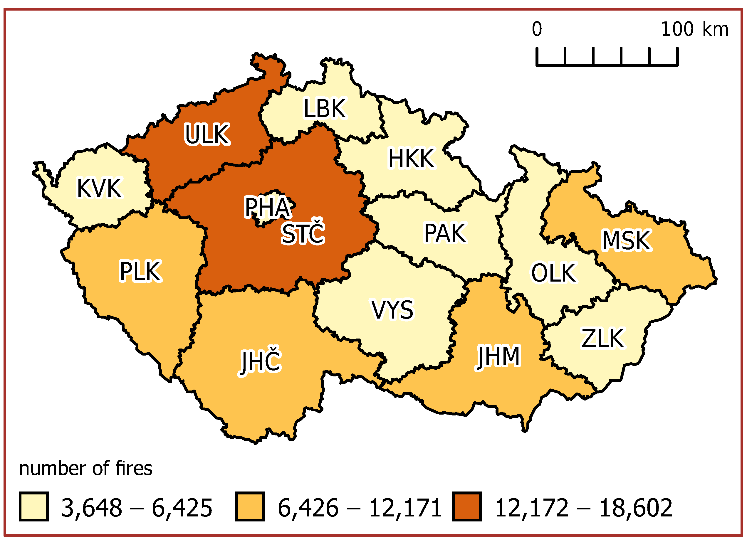
Therefore, to properly plan these resources (e.g., spending more money on wildland fire suppression in some regions), evaluating the occurrence of wildland fires in the various regions is necessary. The simplest way is the count the number of wildland fires in the regions, as shown in Figure 3 and Figure 4. This simple summary gives us a basic review of which regions have more difficult wildland fire situations, and where the resources for wildland fire suppression should be mainly allocated.
However, the absolute values concerning the various regions, which differ substantially in population and area, are usually less helpful than those related to the population or area when comparing the danger in various regions. Nevertheless, in this case, these values can provide a primary picture of the situation. Moreover, they give us a basic idea concerning the distribution of resources for managing wildland fires.
From Figure 3 and Figure 4, we can clearly see the regions of the Czech Republic which are most affected by wildland fires. Furthermore, we can also see that the number of wildland fires has substantially varied over time.
Comparing the absolute values of wildland fires in the regions gives us a helpful picture of the situation for resource planning purposes. However, to compare the wildland fire danger in the regions with various areas and populations, the relative values taking into account the differences between regions should be used, instead of the absolute number of wildland fires.
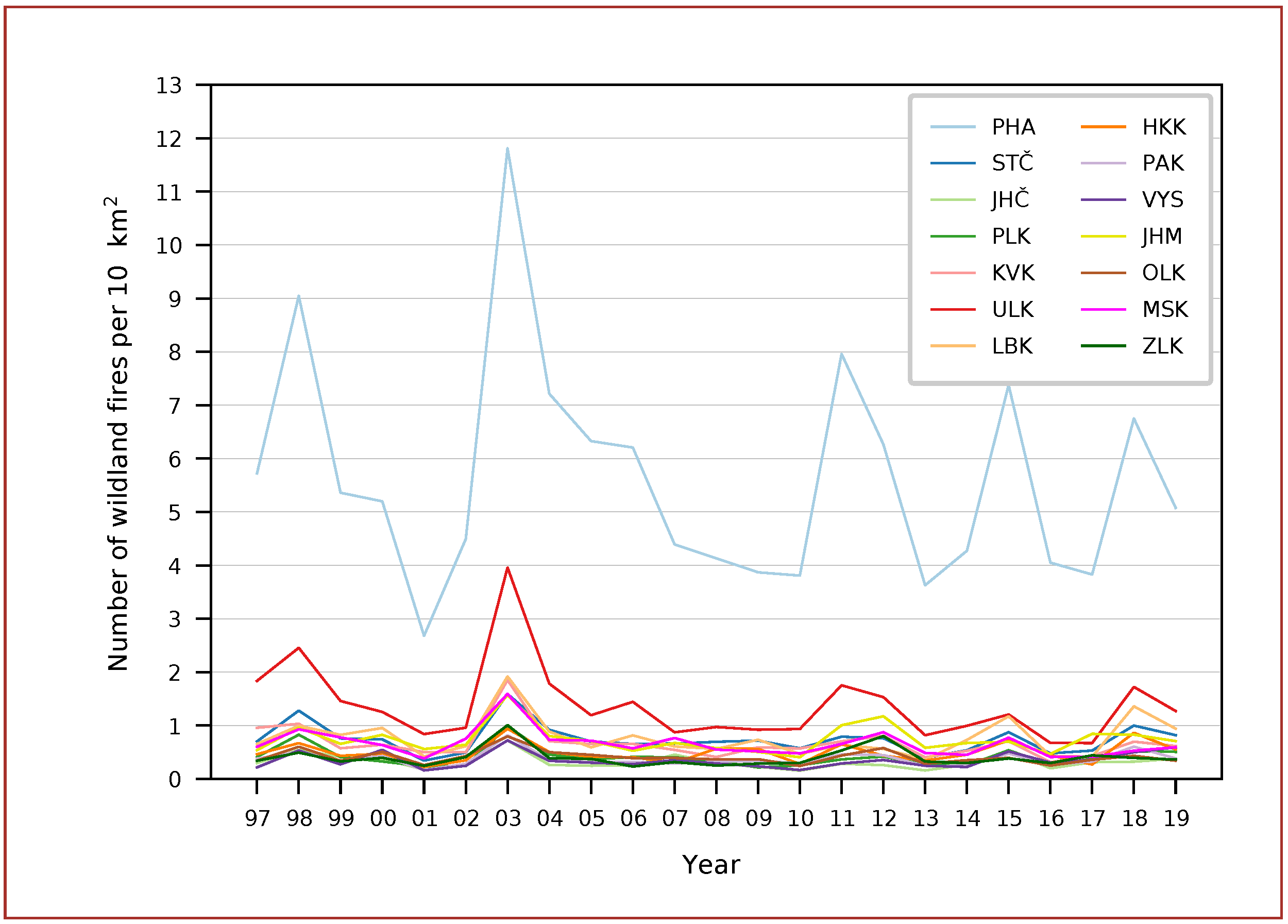
The simplest way to carry out this conversion is to divide the absolute number of wildfires by the number of the inhabitants in the given region (see Figure 5 and Figure 6) or by the region’s area (Figure 7 and Figure 8). These comparisons give us substantially different pictures of the situation.
When comparing the number of wildland fires per number of inhabitants in a given region, in regions where these values are high, the behavior of the common public should be one of the essential factors contributing to the occurrence of wildland fires. Considering this fact, fire prevention should focus on the behavior of residents in these regions, in order to minimize the occurrence of wildland fires.
Using the number of wildland fires per region area provides us with yet another different picture of the situation. This comparison shows that, in one region—the Capital City of Prague—the situation is entirely different from the other regions, meaning that a different approach to the problem of wildland fires in this region will likely be required. We should consider the ways in which this region differs from the other regions, such as its high population density and the terrain profile (e.g., narrow river walleye carved into plains, limestone karst areas, and so on). We may even ask whether the classification of fires in this region as wildland fires is appropriate.
It can also be interesting to compare the wildland fire situation in the other most-populated cities in the Czech Republic with that in Prague; in particular, the situation in the second-most populated city in the Czech Republic, Brno (South Moravian Region, JHM) was similar to the situation in Prague.
In general, we can state that the number of wildland fire numbers divided by the region’s area is not suitable for rapid assessment of the fire danger in various regions, and further clarification of the various factors influencing the temporal and spatial behavior of this quantity is necessary.
Using the numbers of wildland fires to compare the fire danger in various regions is suitable for an initial data survey, but this is only one of the many possible ways. In addition, other possible strategies may utilize various quantitative emergency attributes, such as, the number of involved engines, burnt area, damages, and duration of the response. These attributes are a standard part of the emergency record in the database table of emergencies and can be easily obtained, according to the current needs.
5. Time Course of Various Groups of Wildland Fires
As mentioned above, the set of wildland fires can be split into three groups, according to the object type on which fire took place.
The first group consists of wildland fires of the field type. This group encompasses wildland fires on fields in various states. A close look at the number of fires by year (Figure 9) indicates that this group had one dominant component: straw in the field fires. This dominant component had a substantially higher share of fires in this group than the other groups. Moreover, the other components of this group did not follow closely its time pattern.
The second group of wildland fires—forest fires—followed the behavior of the first group. Again, there was one dominant component: forest grass cover fires (Figure 10). Surprisingly, the character of this type of cover was slightly similar to the dominant type in the first group (i.e., straw in the field). The other components of this group again had a substantially lower share of the fires; however, they followed the pattern of the dominant group more closely, compared with the situation in the first group.
The last group of wildland fires—other wildland fires—also had one dominant component, but the number of fires in this component was closer to that in other components than in the other groups (Figure 11). Furthermore, the other types of fires followed the pattern of the dominant type more closely than in the case of the other groups. The predominant type of fire in this group—meadows—was similar to the predominant types in the other groups.
All three of the above-mentioned groups of wildland fires had similar predominant components, consisting of a grass or grass-like cover (i.e., straw in the field, forest grass cover, and meadows). This fact can be utilized in many ways in preparation for emergencies. First, the training of both professional and voluntary firefighters may focus on fires of this kind. Second, the units can be equipped with special tools that are more suitable for managing such fires. Finally, fire prevention efforts have to be focused on the prevention of this kind of fire; including, but not limited to, the education of the common public and fire protection measures during fire-risk work in grass-like environments.
6. Results
This article provides the basic characteristics of wildland fires in the regions of the Czech Republic, successfully demonstrating that an initial review of the data collected by the FRS of CR operational centers for emergency evidence purposes can provide vital information for the fighting of wildland fires. Furthermore, the initial data review and identification of weak data points (e.g., missing or wrong values) were necessary for every analysis carried out afterwards. Even this elementary data review can lead to the findings which are directly applicable to the fire prevention and suppression daily work of firefighters.
Data concerning emergencies collected by the operational centers of the FRS of CR were used, covering more than 20 years (1997–2019) of the management of emergencies in the Czech Republic. Considering this fact, the data quality mirrors the development of information systems and information technologies, as well as the organizational changes in the emergency management sector in the Czech Republic. Therefore, statistical analysis carried out on these data must consider the quality of the data and carefully deal with problems in it. Furthermore, as was documented in the case of logging the locations of emergencies, each decision concerning the collection of statistical data must be carefully planned and organized. If it is not, the introduction of changes will be unnecessarily long, and the quality of the data may remain problematic for an excessively long time.
The regions of the Czech Republic substantially differ in number of wildland fires. On the other hand, the number of fires held a considerably similar pattern across the regions over time. Such a situation provides the possibility for efficiently planning the resources necessary for wildland fire fighting, according to regional needs.
Comparison of the wildland fire danger in various regions was made possible by converting the absolute number of fires to a relative number considering the difference in inhabitants or area between regions. The estimation of fire danger, in this way, makes it possible to focus various fire prevention campaigns more effectively.
The wildland fires were selected from all emergency data, according to the type of object on which they occurred. This selection procedure provided a set that is similar in commonly used resources for fire management. On the other hand, the collection contains many categories that behave differently over time, with respect to the annual sum of fires. Therefore, analyses of this wildland fire data must take into consideration the heterogeneity of the selected data.
The difference in the share of various wildland fire types enabled us to focus on the most important types of fires, both from an emergency prevention and management point of view.
7. Discussion
The information system and data structures used by the operational centers of the FRS of CR, mainly for emergency evidence purposes, seem to have been designed so well that the collected data can be used for analytical and planning purposes. This fact is somewhat of a pleasant surprise, as the information system and data structures were designed more than two decades ago, and information systems have generally undergone rapid development during this period.
Furthermore, even the introductory data survey—focused on data quality issues and basic spatial and non-spatial characteristics—provided important information, which can be used to support the strategic decisions of the FRS of CR.
The introductory data survey provided us with the necessary background for the usage of advanced methods of spatial and non-spatial statistics. Without this introductory survey, the results obtained by advanced statistical methods cannot be adequately interpreted, and may even be misleading. This fact is essential, especially if the analysis results can influence people’s lives, such as is the case for the prevention and fighting of wildland fires.
The importance of the introductory wildland fire data survey appeared more clearly in light of the usage of wildland fire data as a background for planning the resources necessary for fighting wildland fires in the regions of the Czech Republic in the near future, which is expected to (among other things) use spatial and non-spatial statistical methods. In addition to planning the resources for firefighting, this introductory survey can be used as a starting point for further research utilizing more advanced statistical methods, including spatial statistical techniques, thus leading to a deep understanding of the mechanisms leading to wildland fires.
A deeper understanding of the mechanisms leading to emergencies can substantially improve the effectiveness of the prevention of wildland fires and the provision of firefighting resources and efforts, leading to better service provided by the FRS of CR to the citizens of the Czech Republic.
Furthermore, the results provide guidelines on how to carry out such a survey in the case of other types of emergencies or geographical areas.
Sharing information about wildland fires, as presented in this article, as broadly as possible across various countries and areas with different climates, can allow for the establishment of a common picture of the wildland fire situation. Furthermore, such a picture can serve as a background for a deeper understanding of their occurrence on a trans-national or even continental scale. Such research is expected to substantially contribute to understanding the relationships between the occurrence of wildland fires and climate change.
A good starting point for this effort should be annual reports on the forest fire situations in Europe, the Middle East, and North Africa [13,14]. Unfortunately, these reports do not provide access to the source data. It would be beneficial if the source data of such reports were accessible, both in human and machine-readable form and with a broad set of standardized attributes.
Such an idea is inspired, among other things, by the concept of Digital Earth, an interactive digital replica of the entire planet that can facilitate a shared understanding of the multiple relationships between the physical and natural environments and societies [15]. The concept of Digital Earth enables the sharing of data and knowledge of the relationships between various phenomena occurring at trans-national scale. It is also suitable for reporting practices that have been already tested and implemented in one locality which can be successfully adapted in another.
The sharing of practices is important in any field of human activity, including disaster risk management [16,17,18].
It is also necessary to mention that any efforts leading to disaster risk reduction and disaster risk prevention are closely related to the United Nations Sustainable Development Goals. All of these activities can hardly be imaginable without the broad usage of statistical methods on both spatial and non-spatial data [19].
Wildland fires are probably the least sensitive data concerning emergencies. For this reason, sharing of related data across nations will probably be the least problematic. Moreover, there should be national and trans-national interest in mitigating the consequences of wildfires.
The shared data should contain the location of the wildland fire and some attributes describing it (e.g., the datum, duration of the intervention, number of the involved engines and firefighters, the burned area, type of the burned vegetation, and estimation of the damages). Such a data structure makes both spatial and non-spatial statistical methods applicable. Moreover, it makes it possible to use the broadest spectrum of statistical approaches in order to understand the occurrence of wildland fires in the space and time, thus substantially improving preparedness for wildland fires.
Another issue that should be further discussed is the visualization of temporal and spatial dependent variables related to the emergencies and their spatial and non-spatial statistical characteristics. There have been some proposals for the cartographic visualization of natural risks and disasters [20]. Still, more understandable methods for displaying large multivariate temporal and spatial dependent datasets should be proposed in the future, as the (big) data become available.
The various spatial and non-spatial data concerning emergencies flow fluently into the information systems of the operational centers of the FRS of CR. Therefore, it seems to be beneficial to design automated procedures based on spatial and non-spatial statistic methods, which are focused on anomalies and monitoring the dependencies between various variables and the occurrence of emergencies. Such procedures should enable rapid reaction to such situations and the efficient usage of resources by the FRS of CR.
The approaches and ideas mentioned in this article apply not only to the wildland fires, but also to other types of emergencies.
Funding
Publication of the article was supported by Masaryk University project MUNI/A/1393/2021 “Integrated geographic research of dynamic natural and social processes”.
Institutional Review Board Statement
Not applicable.
Informed Consent Statement
Not applicable.
Data Availability Statement
The data used to create the outputs in this article are internal data of the FRS of CR and contain sensitive information. For this reason, they cannot be publicly available. However, the FRS of CR struggles to make them open to the common public as much as possible, while not harming the privacy of the victims of emergencies. It publishes yearly [21,22] and quarterly reports [23], which are publicly available, in which data are summarized on a regional and district basis to protect the privacy of the victims.
Acknowledgments
The author of the article is very much indebted to Pavel Lukeš from the General Directorate of Fire Rescue Service of the Czech Republic for providing access to the data. He is also deeply grateful to other colleagues from the General Directorate of the Fire Rescue Service of the Czech Republic for their participation in the discussion leading to the classification of fires as wildland fires. Furthermore, he would like to express the greatest appreciation to its tutor, Milan Konečný, for his endless patience. Finally, the author specially thanks the Masaryk University, Faculty of Science, Institute of Geography for moral, scientific, and material support of his work.
Conflicts of Interest
The authors declare no conflict of interest. The funders had no role in the design of the study; in the collection, analyses, or interpretation of data; in the writing of the manuscript, or in the decision to publish the results.
Abbreviations
The following abbreviations are used in this manuscript:
| ČR | Czech Republic |
| FRS of CR | Fire Rescue Service of the Czech Republic |
References
- Romero-Calcerrada, R.; Novillo, C.J.; Millington, J.D.A.; Gomez-Jimenez, I. GIS analysis of spatial patterns of human-caused wildfire ignition risk in the SW of Madrid (Central Spain). Landsc. Ecol. 2008, 23, 341–354. [Google Scholar] [CrossRef]
- Oliveira, S.L.J.; Pereira, J.M.C.; Carreiras, J.M.B. Fire frequency analysis in Portugal (1975–2005), using Landsat-based burnt area maps. Int. J. Wildland Fire 2011, 21, 48–60. [Google Scholar] [CrossRef]
- Ganteaume, A.; Jappiot, M. What causes large fires in Southern France. For. Ecol. Manag. 2013, 294, 76–85. [Google Scholar] [CrossRef] [Green Version]
- Arganaraz, J.P.; Radeloff, V.C.; Bar-Massada, A.; Gavier-Pizarro, G.I.; Scavuzzo, C.M.; Bellis, L.M. Assessing wildfire exposure in the Wildland-Urban Interface area of the mountains of central Argentina. J. Environ. Manag. 2017, 196, 499–510. [Google Scholar] [CrossRef] [PubMed]
- National Park Service|USDA Forest Service-Fire Terminology. Available online: https://www.fs.fed.us/nwacfire/home/terminology.html (accessed on 13 September 2021).
- National Wildfire Coordinating Group-Glossary of Wildland Fire. Available online: https://www.nwcg.gov/glossary/a-z/sort/w (accessed on 13 September 2021).
- Federal Wildland Fire Policy Terms and Definitions. Available online: https://www.nwcg.gov/sites/default/files/docs/eb-fmb-m-19-004a.pdf (accessed on 13 September 2021).
- Wildfire Glossary. Available online: https://www2.gov.bc.ca/gov/content/safety/wildfire-status/about-bcws/glossary (accessed on 13 September 2021).
- Wildfire. Available online: https://en.wikipedia.org/wiki/Wildfire (accessed on 13 September 2021).
- Fire Rescue Service of the Czech Republic-Mission and Tasks. Available online: https://www.hzscr.cz/hasicien/article/fire-rescue-service-of-the-czech-republic-mission-and-tasks.aspx (accessed on 14 September 2021).
- Constitutional Act of the Czech Republic. Available online: https://en.wikipedia.org/wiki/Constitutional_act_of_the_Czech_Republic (accessed on 29 September 2021).
- Ústavní Zákon o Vytvoření Vyšších územních Samosprávných Celků a o Změně ústavního zákona České Národní Rady č. 1/1993 Sb., Ústava České Republiky. Available online: https://www.zakonyprolidi.cz/cs/1997-347 (accessed on 29 September 2021).
- San-Miguel-Ayanz, J.; Durrant, T.; Boca, R.; Maianti, P.; Liberta, G.; Artes Vivancos, T.; Jacome Felix Oom, D.; Branco, A.; De Rigo, D.; Ferrari, D.; et al. Forest Fires in Europe, Middle East and North Africa 2019; Publications Office of the European Union: Luxembourg, 2020. [Google Scholar]
- San-Miguel-Ayanz, J.; Durrant, T.; Boca, R.; Maianti, P.; Libertà, G.; Artes Vivancos, T.; Jacome Felix Oom, D.; Branco, A.; De Rigo, D.; Ferrari, D.; et al. Forest Fires in Europe, Middle East and North Africa 2020; Publications Office of the European Union: Luxembourg, 2021. [Google Scholar]
- Digital Earth. Available online: https://ec.europa.eu/jrc/en/research-topic/digital-earth (accessed on 29 September 2021).
- Konečný, M.; Bandrova, T.; Kubíček, P.; Marinova, S.; Štampach, R.; Stachoň, Z.; Řezník, T. Digital Earth for Disaster Mitigation. In Manual of Digital Earth; Guo, H., Goodchild, M.F., Annoni, A., Eds.; Springer: Singapore, 2020; pp. 495–526. Available online: https://link.springer.com/book/10.1007/978-981-32-9915-3 (accessed on 29 September 2021).
- Konečný, M.; Reinhardt, W. Early warning and disaster management: The importance of geographic information (Part A). Int. J. Digit. Earth 2010, 3, 217–220. [Google Scholar] [CrossRef]
- Konečný, M.; Reinhardt, W. Early warning and disaster management: The importance of geographic information (Part B). Int. J. Digit. Earth 2010, 3, 313–315. [Google Scholar] [CrossRef]
- Konečný, M.; Bandrova, T.; Kubíček, P.; Stachoň, Z.; Štampach, R.; Shen, J.; Rotanova, I.; Brodský, J.; Špulák, P. Strategies of Disaster Risk Reduction On The Background Of U.N. GGIM And Digital Belt And Road Efforts. In Proceedings of the 8th International Conference on Cartography and GIS, Nessebar, Bulgaria, 20–25 June 2022; Bandrova, T., Konečný, M., Marinova, S., Eds.; Bulgarian Cartographic Association: Sofia, Bulgaria, 2020; Volume 1. ISSN: 1314-0604. Available online: https://iccgis2020.cartography-gis.com/proceedings-vol-1/ (accessed on 29 September 2021).
- Konečný, M.; Bandrova, T. Proposal for a Standard in Cartographic Visualization of Natural Risks and Disasters. Int. J. Urban Sci. 2006, 10, 142–149. [Google Scholar] [CrossRef]
- Statistical Yearbooks-Fire Rescue Service of the Czech Republic. Available online: https://www.hzscr.cz/hasicien/article/statistical-yearbooks.aspx (accessed on 29 September 2021).
- Statistické Ročenky Hasičského Záchranného Sboru ČR. Available online: https://www.hzscr.cz/clanek/statisticke-rocenky-hasicskeho-zachranneho-sboru-cr.aspx (accessed on 29 September 2021).
- Průběžné čtvrtletní Přehledy. Available online: https://www.hzscr.cz/clanek/info-servis-statistiky-prubezne-ctvrtletni-prehledy.aspx (accessed on 29 September 2021).
Figure 1.
Wildland fire coordinate logging. The graph depicts the percentage of logged coordinate values from all wildland fires in a given year.
Figure 1.
Wildland fire coordinate logging. The graph depicts the percentage of logged coordinate values from all wildland fires in a given year.

Figure 2.
Regional wildland fire coordinate logging. The graph depicts the percentage of undefined coordinate values from all wildland fires in a given year for 14 regions of the Czech Republic, including the Capital City of Prague and for the whole of the Czech Republic.
Figure 2.
Regional wildland fire coordinate logging. The graph depicts the percentage of undefined coordinate values from all wildland fires in a given year for 14 regions of the Czech Republic, including the Capital City of Prague and for the whole of the Czech Republic.

Figure 3.
Time-series of number of wildland fires in 14 regions of the Czech Republic, including the Capital City of Prague. The order of the regions respects the order in the Constitutional Act of the Czech Republic [11] which establishes these regions [12]. The same ordering is used in the following figures.

Figure 4.
Spatial distribution of wildland fires in the regions of the Czech Republic. Data refer to the period 1997–2019.
Figure 4.
Spatial distribution of wildland fires in the regions of the Czech Republic. Data refer to the period 1997–2019.

Figure 5.
Time-series of wildland fires per 1000 inhabitants in 14 regions of the Czech Republic, including the Capital City of Prague.
Figure 5.
Time-series of wildland fires per 1000 inhabitants in 14 regions of the Czech Republic, including the Capital City of Prague.

Figure 6.
Spatial distribution of wildland fires per 1000 inhabitants in the regions of the Czech Republic. Data refer to the period 1997–2019.
Figure 6.
Spatial distribution of wildland fires per 1000 inhabitants in the regions of the Czech Republic. Data refer to the period 1997–2019.

Figure 7.
Wildland fires per per 10 km in the 14 regions of the Czech Republic, including the Capital City of Prague.
Figure 7.
Wildland fires per per 10 km in the 14 regions of the Czech Republic, including the Capital City of Prague.

Figure 8.
Spatial distribution of wildland fires per 10 km in the regions of the Czech Republic. Data refer to the period 1997–2019.
Figure 8.
Spatial distribution of wildland fires per 10 km in the regions of the Czech Republic. Data refer to the period 1997–2019.

Figure 9.
Various kinds of field fires in the Czech Republic.

Figure 10.
Various kinds of forest fires in the Czech Republic.

Figure 11.
Various kinds of other wildland fires in the Czech Republic.

Publisher’s Note: MDPI stays neutral with regard to jurisdictional claims in published maps and institutional affiliations. |
© 2022 by the author. Licensee MDPI, Basel, Switzerland. This article is an open access article distributed under the terms and conditions of the Creative Commons Attribution (CC BY) license (https://creativecommons.org/licenses/by/4.0/).
Share and Cite
MDPI and ACS Style
Špulák, P. Wildland Fires in the Czech Republic—Review of Data Spanning 20 Years. ISPRS Int. J. Geo-Inf. 2022, 11, 289. https://doi.org/10.3390/ijgi11050289
AMA Style
Špulák P. Wildland Fires in the Czech Republic—Review of Data Spanning 20 Years. ISPRS International Journal of Geo-Information. 2022; 11(5):289. https://doi.org/10.3390/ijgi11050289
Chicago/Turabian StyleŠpulák, Pavel. 2022. "Wildland Fires in the Czech Republic—Review of Data Spanning 20 Years" ISPRS International Journal of Geo-Information 11, no. 5: 289. https://doi.org/10.3390/ijgi11050289
Note that from the first issue of 2016, this journal uses article numbers instead of page numbers. See further details here.