Article

Sustainability of Village Tank Cascade Systems of Sri Lanka: Exploring Cascade Anatomy and Socio-Ecological Nexus for Ecological Restoration Planning

by
Sujith S. Ratnayake
1,2,*,
Lalit Kumar
3,
Punchi B. Dharmasena
4,
Harsha K. Kadupitiya
5,
Champika S. Kariyawasam
1,2 and
Danny Hunter
6
1
Ecosystem Management, School of Environmental and Rural Science, University of New England, Armidale, NSW 2351, Australia
2
Ministry of Environment, Battaramulla 10120, Sri Lanka
3
East Coast Geospatial Consultants, Armidale, NSW 2350, Australia
4
Faculty of Agriculture, Rajarata University of Sri Lanka, Mihintale 50300, Sri Lanka
5
Natural Resources Management Centre, Department of Agriculture, Peradeniya 20400, Sri Lanka
6
Alliance of Bioversity International and CIAT, Via di San Domenico, 1, 00153 Rome, Italy
*
Author to whom correspondence should be addressed.
Challenges 2021, 12(2), 24; https://doi.org/10.3390/challe12020024
Submission received: 15 July 2021 / Revised: 6 September 2021 / Accepted: 9 September 2021 / Published: 23 September 2021

Abstract

:
Village Tank Cascade Systems (VTCSs) in the Dry Zone of Sri Lanka have evolved as sustainable ecosystems through human interventions to ensure water availability and other services for people and their environs during the last few millennia. However, VTCSs are vulnerable to global environmental changes resulting in continual deterioration of ecological health and hydro-socio-ecological status, crucial for the food and livelihood security of rural farming communities in the dry zone. This paper seeks to explore resource systems of the Mahakanumulla VTCS located in Anuradhapura district of Sri Lanka to (i) identify the spatial metrics linked to the sustainability and socio-ecological resilience of the VTCS, and (ii) determine interactions among system elements and their impacts on productivity and restoration challenges. The spatial analysis was conducted using a Digital Elevation Model (DEM), recent digital topographic map layers and Google Earth images to understand the spatial distribution and ensemble of tank environs. Participatory field assessment data were also used to determine socio-ecological nexus and factors that contribute to the reduction of ecological productivity of VTCS. The study revealed that the ensemble of tank environs is significant for providing regulatory and supporting ecosystem services (ES) and synergistic relationships with provisional ES of the VTCS. Results also revealed that the complex land-water-biodiversity-climate and food nexus that determines the productivity of the VTCS could be adopted in VTCS ecological restoration planning. The study presents a comprehensive framework to analyse causal factors and processes leading to reduction of overall productivity linked with variables of socio-ecological properties, vulnerability and resilience of the VTCS landscape.

1. Introduction

Surface runoff water harvesting systems through small tanks in micro-watersheds are found in several Mediterranean and Asian countries [1]. In order to achieve the targets of the Sustainable Development Goals especially SDG-2 and SDG-6, it is vital to restore these systems using community participation to enhance surface and groundwater management, especially in developing countries [2,3,4]. The Village Tank Cascade System (VTCS) is a complex socio-ecological system existing in the Dry and Intermediate Zones of Sri Lanka. In the country, the VTCS bears unique features, not only hydrological and physiological aspects but also deeply interwoven elements with socio-hydro-ecological characteristics of the landscape, ensuring their sustainability and socio-ecological resilience. The VTCS was first defined as a ‘connected series of village tanks organized within a meso-catchment of the dry zone landscape, storing, conveying and utilizing water from an ephemeral rivulet’ [5]. However, it was found that the functionality and concept of the VTCS go beyond its water-based ecosystem services. Considering its ecological functions and socio-ecological production outcomes, a new interpretation has been provided by Dharmasena [6] as ‘an ecosystem where water and land resources are organized within the micro-catchments of the dry zone landscape, providing basic needs to human, floral and faunal communities through water, soil, air and vegetation with human intervention on sustainable basis’. VTCS is considered one of the oldest and most advanced agricultural irrigation systems that has evolved in the world [7,8]. More than 14,000 small village tanks are still in use in the Dry and Intermediate Zones of Sri Lanka, with an irrigation potential of about 246,540 ha of paddy lands [6,9]. Revitalization of VTCSs is essential for achieving climate resilience and food security in these peasant communities of Sri Lanka.
The resilient properties and adaptive capacity of these systems have been realized for more than several millennia. The VTCS provides a classic example of how human wellbeing can overcome the natural shocks of the past two millennia in harmony with nature employing practices preserving biodiversity and ecosystem services [8]. Considering its unique landscape and ecological features harmonized with the local culture and human life, the VTCS was been declared as a Globally Important Agricultural Heritage Systems (GIAHSs) by the United Nations Food and Agriculture Organization (FAO) in 2018 [10]. Global environmental initiatives, which have dealt with socio-ecologically sensitive production landscapes (SESPLs), have shown keen interest in studying the multifaceted values of these Village Tank Cascade Systems (VTCSs) [11,12]. Several international funding agencies, such as the Green Climate Fund (GCF) and the Global Environment Facility (GEF) have initiated projects with government and non-government stakeholders for restoration of these systems, taking into consideration the capacity of the system to address climate change impacts for sustainable rural livelihoods in the Dry Zone of Sri Lanka.
A VTCS cannot be simplified to its physical structures and practices. Besides providing irrigated water for paddy cultivation, these small tank systems play significant socio-ecological, socio-cultural, and socio-economic roles in the livelihoods of rural farmers and communities. The impairment of VTCS hydro-socio-ecology functioning, mainly due to climate, land use and demographic changes, has significantly impacted the sustainability of the system. Recent restoration efforts carried out by different agencies have not analysed systematically the socio-ecological nexus and functions, ecologically important micro-land uses and their spatial connections. This has caused unintended degradation to cascade anatomy during various VTCS rehabilitation projects. Better understanding these characteristics is important in determining causal factors of the reduction of ecological productivity of the VTCS. However, little research has been undertaken to study the cascade ecology of the VTCS landscape at different scales and to understand the capacity of providing ES at the landscape level. In addition, while several studies of VTCSs have focused on specific subject areas such as soil and water properties [13,14,15], hydrology [16,17,18,19,20,21,22], limnology [7,23,24] and sedimentology [25,26], there have been hardly any systematic studies undertaken to analyse socio-ecological system characteristics, functions, and interactions based on a system thinking approach. Therefore, this study aims to address this research gap by evaluating the spatial and socio-ecological nexus in the Mahakanumulla VTCS located in Anuradhapura District of Sri Lanka. The specific objectives of this study were to (i) explore the spatial distribution pattern and cascade anatomy of VTCS in Sri Lanka, (ii) identify subsystems, variables, and interactions between system properties in terms of the land-water-biodiversity-climate and food nexus, and (iii) identify causal factors and nexus that contribute to the reduction of ecological and socio-economic productivity of the system.

2. Materials and Methods

2.1. Study Area

The Mahakanumulla VTCS, which is one of the VTCSs found in the Nachchaduwa reservoir watershed in the Anuradhapura district, was selected to study the cascade anatomy and socio-ecological nexus (Figure 1). The entire Dry Zone landscape of Sri Lanka was selected to explore the spatial distribution patterns of the VTCSs.

2.2. Data Collection Sources

The spatial data sources used to achieve the specific objective (i) in this study included (a) Global Digital Elevation Model V003 (30 m), 2018, accessed 5 January 2021 from https://doi.org/10.5067/ASTER/ASTGTM.003 and (b) digital map layers of different spatial levels and scales obtained from Department of Agrarian Development of Sri Lanka, Land Use Policy Planning Department of Sri Lanka and Survey Department of Sri Lanka. Nonspatial data and information used for the specific objectives (ii) and (iii) in this study were extracted from field assessment and survey reports of the study area [27,28] and past studies and resource profiles of the Mahakanumulla VTCS. On-site spatial assessments and field verification surveys were carried out in November and December 2020.

2.3. Exploration of Spatial Distribution Pattern and Spatial Relationships

In order to achieve the specific objective (i), this study assessed and mapped the distribution of VTCSs at the country level, and identified the spatial setting of biophysical components at the VTCS level. Under this task, spatial analysis was performed using ArcGIS for different hierarchical levels from national to VTCS micro-catchment levels (Figure 2). Spatial analysis for mapping was carried out using Digital Elevation Model and digital maps were prepared for land use and land cover (LULC), river basins, cascade systems and village tanks. Further, fine-scale maps of LULC and tank components were developed using a Google Earth image accessed on 23 January 2021 as base maps, and on-screen digitizing was made by employing ArcMap (version 10.8.1) software from Environmental Systems Research Institute, Redlands, California, USA. The results were validated through on-site field verifications assessments and surveys, aerial drone images and making references to resource profiles of the Mahakanumulla VTCS landscape. The on-site spatial assessments and field verification surveys were done in collaboration with the Ministry of Environment, Department of Agriculture and Wayamba University of Sri Lanka under a GEF-funded project on ‘Managing Agricultural Landscapes in Socio-ecologically Sensitive Areas to Promote Food Security, Well-being and Ecosystem Health–Healthy Landscapes Project’ (HLP) (https://www.thegef.org/projects, accessed on 20 January 2021) [28].

2.4. Exploration of Interactions among System Properties

The interactions among the VTCS properties (specific objective ii) were identified by studying socio-ecological subsystems and components of the VTCS and mapping the interactions (nexus) between them in the Mahakanumulla VTCS. The process involved (a) identifying subsystems and their components, (b) unveiling interactions and issues among subsystems’ components and (c) obtaining feedback from key informants and experts on the interactions and issues relevant to the ecological and socio-economic productivity outcomes of the VTCS. The study used data and information from participatory field assessments and surveys conducted by the HLP [27,28].

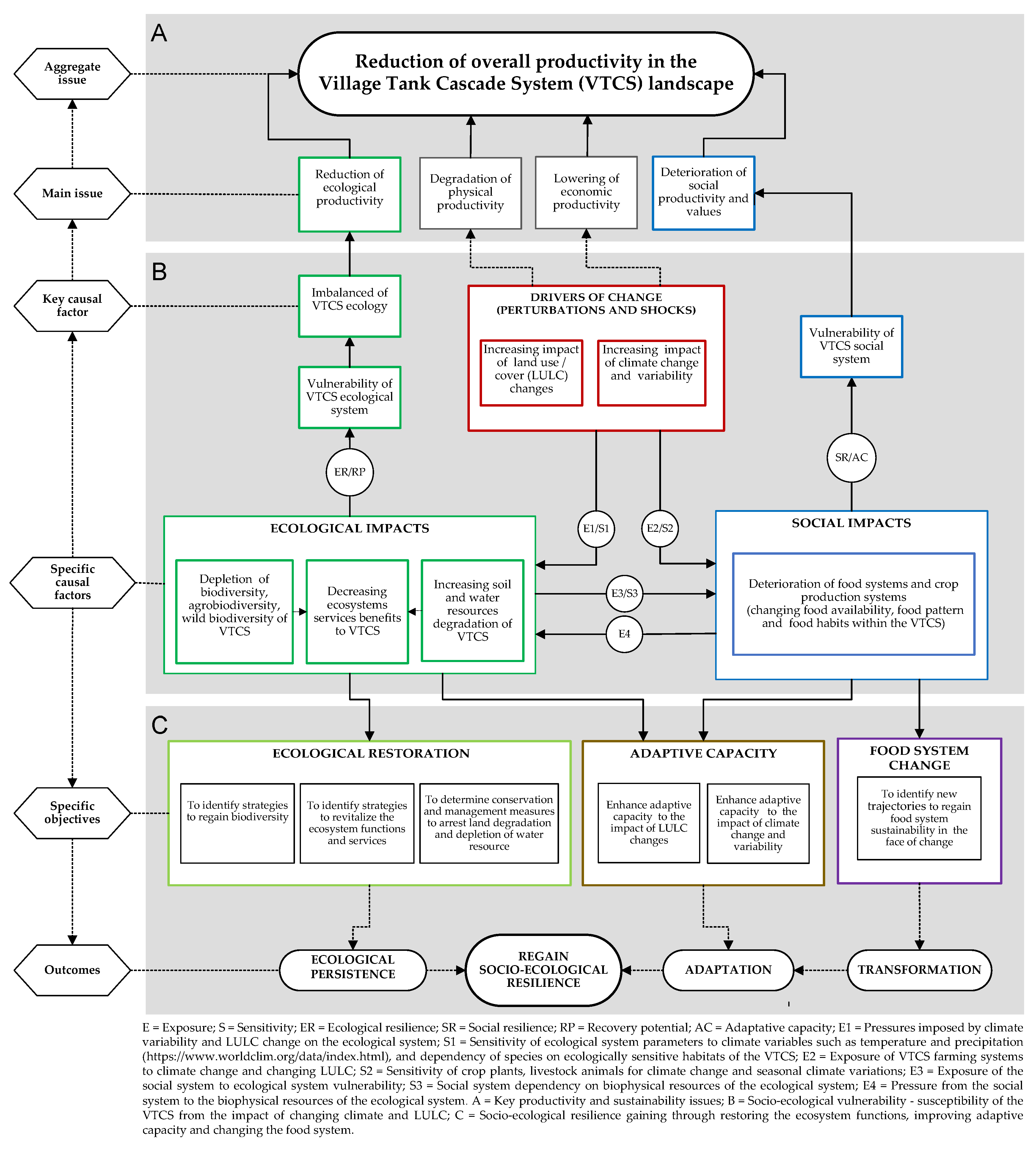
2.5. Identification of Productivity Issues, Linked with Socio-Ecological Properties and Restoration Challenges

The specific objective (iii) of the study was achieved through the identification of specific causal factors that contribute to the reduction of ecological and socio-economic productivity and mapping the relationships among the identified causal factors. Specific causal factors and interactive relationships were identified during the field assessments and surveys of biodiversity, medicinal plants ecosystem services, land degradation and food security conducted by the expert team of the HLP [27,28]. Identified causal factors were prioritized through on-site participatory assessments in the study site. The impact of drivers of change related to climate variability and land use and cover changes were identified through past studies conducted in the study area. The data and information extracted from the field assessments were analysed to determine the implications of direct and indirect relationships among the identified causal factors and indicators based on socio-ecological vulnerability, adaptive capacity and socio-ecological resilience framework to determine ecological restoration strategies [29].

3. Study Findings and Discussion

3.1. Spatial Distribution Pattern and Spatial Relationships

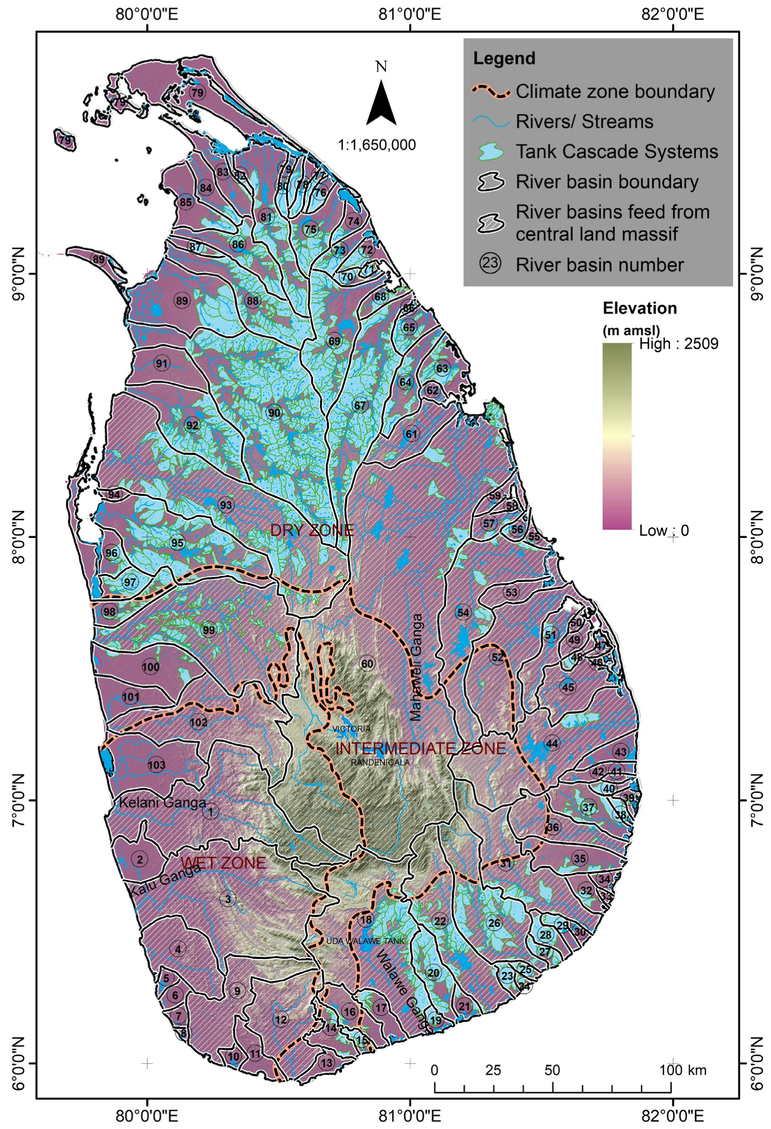
3.1.1. Spatial Distribution of VTCSs in Sri Lanka

The evolutionary process of VTCSs is mainly inspired by three main factors of the dry zone landscape: (i) geomorphology; (ii) hydrology and (iii) the nature of the substratum (pedology, geology, lithology) [30]. The river basins associated with VTCSs experience a rainwater deficit in one season and a surplus during the other season [30,31]. In this context, VTCSs were built taking into consideration the natural geomorphology of the landscape to ensure the availability of water resources throughout the year. There are 1,162 VTCSs identified in Sri Lanka, of which more than 85% of the VTCSs are found at an elevation range of 100–300 m amsl. The majority of VTCSs (90%) are clustered into three major zones, namely North and North-central, North-western, and South and South-eastern [6]. The zones are characterized by hills and valleys supported by water movement, shape and the size of the micro-watersheds. The GIS spatial analysis found that the three VTCSs zones, which represent 21.7% of the country, contribute to 23.3% of paddy lands in Sri Lanka.
Though there are 103 river and major stream basins recorded in Sri Lanka, many of them do not originate from the Central Mountainous Land Massif (CMLM) [32]. The GIS spatial analysis of this study indicated that river basins, which contain the majority of the VTCSs do not have direct surface hydrological connectivity with the CMLM of the country (Figure 3). The area of surface water origin of each river basin was divided into three levels of administrative divisions: Grama Niladhari (GN) division, Divisional Secretariat (DS) division and District Secretariat level (Table 1).
Rainfall regime and water budget are significant factors for determining the agricultural and ecological productivity of the VTCS landscapes. The annual average rainfall in the VTCS study area is 1445 mm, with a temporal variation from 875 to 1875 mm. The distribution is characterized by a well-defined bi-modal rainfall pattern. The evaporation from the free water surface ranges from 3.5 to 7.5 mm/day, and the average daily ambient temperature is 27 °C [15,33]. This indicates water is a limiting factor for agricultural productivity in the VTCS area. The amount and distribution pattern of the rainfall creates four climatic seasons (with two major cultivation seasons) in a year. Highly distinct rainfall regimes, seasonality and water stress have contributed to the evolution of diverse agricultural land use and cropping patterns of the VTCS landscape. [30,34,35]. Substratum features of the VTCSs zones favourably contribute to surface drainage patterns and groundwater availability of the area. Major soil groups (Reddish Brown Earths (60%), Low Humic Gley (30%) and alluvial (10%)) found in the VTCS with distinctly different drainage conditions create the optimum environmental conditions for farmers to adopt a three-fold farming system (lowland paddy, rainfed upland and homestead) in the VTCS. A highly impervious shallow regolith aquifer found in the VTCS area is recharged by seasonal precipitation and seepage from tanks, rivers, and streams continuously throughout the year [30,34,35]. Thus, the above geomorphological. hydrological and substratum features could contribute immensely to reducing the risk of natural disasters, especially climatic stresses in the VTCS. The whole ecological and agricultural productivity in the VTCS is governed by these features.

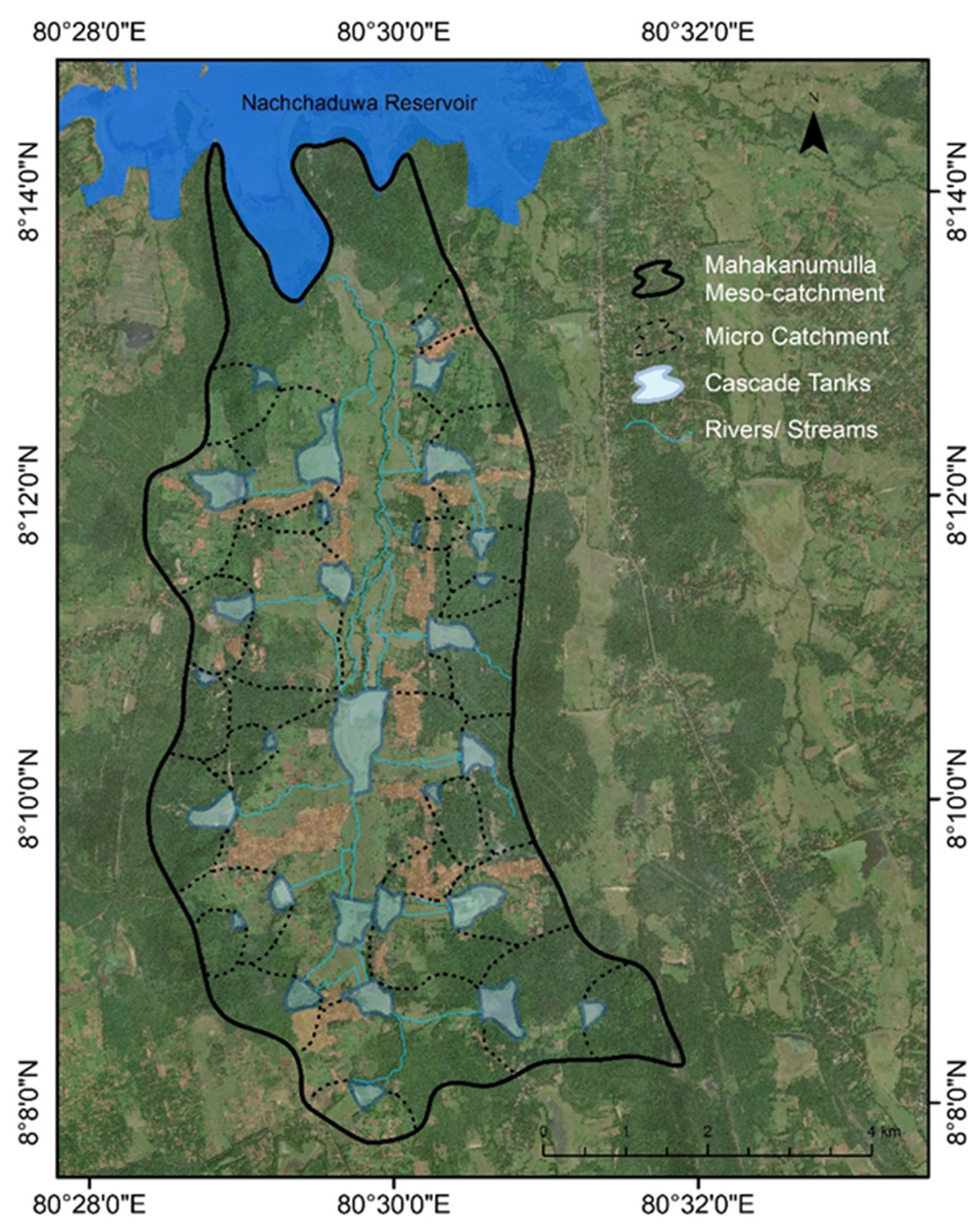
3.1.2. Ensemble of the Cascade System and Its Anatomy

A village tank cascade system is an ensemble of various sizes of tanks interacting hydrologically, ecologically, and socially to form the cascade anatomy, which creates dynamic relationships. A GIS spatial analysis of the study mapped the organization of tanks and spatial setting of ecologically important components in the Mahakanumulla VTCS, with their relative positions, is presented in Figure 4 and Figure 5. In the Mahakanumulla meso-catchment, hydro-ecologically interconnected tanks facilitate efficient re-use of water from an upstream command area to the next lower tank. This contributes to an increase in the water use efficiency for agricultural activities in the meso-catchment [36]. Further, the tank systems perform together with socio-ecological components of the VTCS, while providing basic needs to humans and enhancing the surrounding flora and fauna.
Macro and micro land-use components and their configuration are crucial for the resilience and sustainability of the system. The functions of macro and micro land-use components are interconnected, and their functions are important for the ecological stability of the system. Ecologically important micro-land uses and their functions are discussed in Table 2. Disruption of these ecological functions significantly interrupts the harmony between micro and meso-catchment characteristics of VTCS landscapes. Therefore, the sustainability and productivity of the VTCSs are dependent on a holistic understanding of the micro-land uses and their associated functions.
The system components in Figure 5 include: 1 = tank bed; 2 = tank bund; 3 = downstream reservation (Kattakaduwa); 4 = upstream tree belt (Gasgommana); 5 = upstream shallow tank bed (Wew-thaulla); 6 = upstream immediate catchment (Wew-ismaththa); 7 = shrubland (Landa); 8 = rainfed farmland (Hena); 9 = hamlet (Gangoda); 10 = upper catchment forest; 11 = command area paddy fields; 12 = upstream water-hole (Godawala); 13 = soil ridge (Iswetiya); 14 = common drainage (Kiwul-ela); 15 = irrigation canal; 16 = stream (Ela); 17 = backyard reservation around hamlet (Tis-bambe).

3.1.3. Understanding the Spatial Metric of the VTCS

Different landscape components of the VTCS can have different levels of species richness and functions [38,39]. Hence, proper assessment of landscape indices such as spatial pattern and spatial configuration is important to understand how they affect the landscape processes and relationships when certain changes occur in these indices [40,41,42]. Based on the spatial analysis of the study, socio-ecologically important mosaic of land uses and hydro-ecologically integrated tanks in the Mahakanumulla VTCS create a specific spatial pattern as shown in Figure 6 and Figure 7. Landscape variability–multi-functionality (number of land-use types per unit area) and landscape heterogeneity (number of land-use patches with the same number of land use classes per unit area) are considered key features of evaluating landscape mosaic patterns [43]. In addition, connectivity, shape, biotope types, and eco-tone length per unit area can be taken as indicators of evaluating the VTCS landscape variability and heterogeneity [40,43]. More diverse landscapes are generally more resilient to climatic change than landscapes with lower diversity [44].
Land uses of the socio-ecological systems can be classified based on basic ecological land cover units (e.g., community protected forests, pastures and natural grassland, forest, wetlands, water, plantations), social and cultural units (e.g., local people, traditional knowledge, culture), production systems (e.g., crop and livestock farming, agroforestry, urban agriculture, peri-urban agricultural, home-gardens, inland water associated fisheries), and relief, altitude and slope characteristic (e.g., mountain, highland, lowland, coastal river systems) [45,46,47]. The land use map generated for this study revealed that the Mahakanumulla VTCS comprises most of the above spatial features, providing an environment with multiple livelihood opportunities to the people [6,37].

3.2. Interactions among System Properties

3.2.1. Land-Water-Food Security Nexus

Water and land resources are the most critical elements in the VTCS processes as they are multifunctional and multipurpose and directly linked to the system productivity assuring the sustainability of food production [48]. The study analysed the on-site field assessments data (biodiversity, land degradation), linked with information extracted from the participatory assessments (ecosystem services and food security) of the HLP baseline assessments [27,28], to generate a Land-Water-Food nexus map of the Mahakanumulla VTCS presented in Figure 8. Data and information presented in the map were validated by referring to past studies carried out in the study area, the resource profile of the Mahakanumulla VTCS, and aerial drone images used in the field assessments and GIS spatial analysis. The nexus map revealed that many interactions between critical subsystems of the VTCS are new and have not yet been adequately studied.
The village tank is a seasonal small reservoir, and most of its storage is replenished from surface inflow generated from the tank catchment area. Forest vegetation in the tank catchment area absorbs rainfall and gradually releases water into the tank system. In addition, a shallow regolith aquifer found in the dry zone landscape is replenished with rainfall and maintained by the VTCSs, which brings an additional benefit. The subsurface flow of groundwater feeds command areas situated in lower areas of the valley supporting paddy cultivation [34]. Further, groundwater is utilized through agro-wells for irrigation in the upland seasonal crops farming [50,51,52] and domestic purposes through shallow domestic wells in homesteads [34,53].
The stored water is lost not only due to irrigation but also from evaporation, evapotranspiration, seepage, percolation and bund leakages. Water losses from the catchment, tanks, canals, and fields are found to be more than that used for farming. Studies have revealed that in an average year about 50–60% of the total tank water storage is lost without any apparent use for downstream command area paddy cultivation [49,54]. About 20–30% of wet seasonal (Maha) precipitation from the upstream catchment contributes to the tank water storage. Considering factors of water loss and conveyance efficiency (80%), only 13% of the wet seasonal (Maha) precipitation is available for command area paddy cultivation [31]. A study found that the total tank water loss from the Mahakanumulla VTCS during a dry month is about 12% of the total tank storage [55]. Tank characteristics (shape, water spread area, water depth, tank bund condition, tank bed geometry, location of the tank, condition of the tank associated micro-land uses) and the catchment characteristics (slope, size, shape, vegetation cover, soil condition) affect the tank water balance of the VTCS [54]. Loss of land productivity by various forms of land degradation is a major cause for reduction in crop and livestock production [56]. Diminishing surface and groundwater quality due to human-induced activities, such as the excessive use of pesticides, fertilizer, detergents, and waste dumping [7,24,25,57], can be considered major threats to human health and sustainability of the system [13,55,58]. Surrounding vegetation in the micro-land-use components of the tank significantly contributes to the ecological balance in land and water resources of the VTCS.

3.2.2. Climate Change and Food Security Nexus

The climate change and the food production nexus of the system provide many challenges and substantial trade-offs in terms of VTCSs sustainability [59,60]. Climate change increases the likelihood of extreme climatic events and is identified as a major driver that impacts food security and nutrition of the socio-ecological production landscapes [61,62,63,64,65,66,67,68,69]. The study adopted the climate change impact chain approach (http://cigrasp.pik-potsdam.de/about/impactchains, accessed on 6 March 2021) to map climate-related impacts on resource subsystems of Mahakanumulla VTCS. The study analysed the participatory assessments data and information of the HLP baseline assessment linked with the findings of past studies carried out in the VTCSs landscapes to identify the climate-food nexus illustrated in Figure 9. Data and information presented in the map were validated through online expert and key informant opinion consultation. The climate-food nexus map clearly illustrates the possible impact of climate change and changes of VTCS land uses that have taken place recently on ecosystem health (agro-biodiversity and wild biodiversity) and human well-being (human health, food and nutrition security, livelihood avenues, and human-wildlife coexistence).
The farming patterns of the VTCSs have been adopted to ensure biodiversity conservation, food security, and adaptation to climatic changes. Links between agrobiodiversity and wild biodiversity in the context of climate change and food production in the VTCSs are important; thus, food production and biodiversity conservation may not necessarily be opposed to one another in the VTCS [70]. However, they should be better integrated for achieving optimum outcomes to overcome climate change impacts. In this context, a system-based analysis approach is essential to identify the climate-food-biodiversity nexus [71].
The multifaceted nature of the VTCS provides diverse livelihood opportunities to the local communities. In the Mahakanumulla VTCS, the three different farming systems that have been practised to adapt to climate change variations are (i) irrigated paddy cultivation in the tank command area, (ii) shifting cultivation (Chena) and other diverse seasonal field crops farming in the upstream communal lands under rain-fed conditions and irrigation through agro-wells, and (iii) perennial crops, mostly multipurpose trees in home gardens that utilize mainly subsurface soil moisture [48]. Collectively, these farming systems have maintained a high level of genetic diversity of traditional crop varieties and livestock breeds that enhance the climate resilience of the farming systems. It is believed that a majority of the genetic diversity of rice, including wild relatives, can be traced from these VTCS farming landscapes [72]. Additionally, various agroecological practices adapted by farmers are important to maintain agrobiodiversity and adapt to climate change impacts.
Home gardens in the VTCS landscape are well adapted to climate change shocks and bear high food variety diversity, particularly neglected and underutilized fruit species, edible medicinal plants, indigenous vegetable varieties, tuber crops and spices. The soil moisture in these home gardens is retained for a long period, and horticulture is practised successfully throughout the year [73]. Further, other livelihood options such as animal husbandry, beekeeping, cottage industries, ornamental plant species, and agroforestry are practised to meet nutritional and livelihood needs [74]. However, the full potential of socio-ecological benefits of existing home gardens to sustain climate change impacts have not been fully realized.

3.2.3. Biocultural Diversity, Ecosystem Services and Traditional Knowledge Nexus

VTCSs can be recognized as locally adapted traditional agricultural systems. These systems are based on rich traditional knowledge and are known to have symbiotic relationships between biodiversity and cultural elements, also referred to as bio-cultural diversity [75]. Thus, the evidence of the relationships can be established between biological diversity and cultural practices of the landscape. Traditional knowledge and biodiversity are the key indicators for recognizing GIAHSs and SESPLs established by the FAO [76] and the Satoyama initiative [77] in different regions of the world. The study used the concept of biocultural diversity [78] integrating an ES approach [79], and blended data and information generated from the field assessments and surveys of the HLP (biodiversity, traditional knowledge, food security, ES and medicinal plants) [28] to unveil relationships between biocultural elements in the Mahakanumulla VTCS as illustrated in Figure 10.
The traditional knowledge system (TKS) found in the VTCS, is a combination of the traditional wisdom that has been pursued from long-term challenging experiences with an assemblage of intergenerational effects and natural phenomena from cultural and spiritual roots. Various biophysical components of the VTCS are demonstrated in traditional knowledge, which is essential for the conservation and use of biodiversity and the continuous flow of ES linked with these components. [80,81]. Traditional knowledge practised in the VTCS is associated with agrobiodiversity and wild biodiversity for food production and medicinal plant resources for the traditional medical system (Ayurveda). Although VTCS landscapes have provided a broad range of variety of wild edible plants with medicinal properties, the value of “hidden biodiversity,” which could be of potential value for human health and nutrition is still poorly understood. Field assessments of the HLP revealed that TKS is still used in the VTCS to enhance adaptability and resilience to climate variability, integrating agrobiodiversity and traditional medical practices [27,28,82,83,84]. Around the time of the Green Revolution (1960s), the traditional knowledge practised in these agricultural systems was gradually eroded by the promotion of high-input intensive farming practices, leading to the gradual disappearance of the TKS [30]. However, some of the elements of the TKS in VTCSs still exist and function to a certain degree, despite the forces of global environmental change [6,83,85].
The disappearance of such knowledge and practices within the system is considered one of the major challenges for the sustainability of VTCSs. Identification of TKS values and quantifying specific biocultural elements (i.e., the “social-ecological keystone” relationships concept) [86] is an important aspect of the VTCS resilience that depends on the ability to adapt in the face of climate change without sacrificing biological and cultural wealth and its productive capacity [78].

3.3. Productivity Issues, Linked with Socio-Ecological Properties and Restoration Challenges

Proper understanding of social and ecological elements and their relationships to climatic and non-climatic stresses due to changing climate and land use/cover (LULC) is essential to ensure the sustainability of VTCS restoration projects. These stresses have caused the ecological imbalance of the VTCS, challenging its sustainability and resilience in the context of food production and socio-ecological values. During the past two decades, the integrity and functions of VTCSs have been degraded significantly affecting the provision of ecosystem goods and services. For example, deterioration of micro-land use components and upstream catchment forest has had a significant impact on biotic diversity (species diversity, functional diversity and vegetation structure), abiotic heterogeneity (soil erosion and land degradation) and imbalance of water budget (soil moisture, evaporation, surface runoff), leading to a significant reduction in the capacity of supplying and regulating ES in the VTCS [87,88,89,90]. Thus, the study examined the identified causal factors and their interactive relationships [27,28] within the framework of resilience, adaptive capacity, and the vulnerability (RACV) concept [29], while incorporating exposure and sensitivity indices specific to Mahakanumulla VTCS. The process is illustrated in Figure 11.
It was observed that climate, LULC and demographic changes increase the exposure (E) and sensitivity (S) of the ecological system, disturbing the continuous supply of ES to the social system. This creates ES supply and demand mismatches in food production in the VTCS.
Recent studies have shown that various factors impact the ecological productivity of the VTCSs. For instance, agricultural expansion into ecologically sensitive areas of the major VTCS zones due to demographic changes and urbanization has led to a drastic reduction in forest cover during the last two decades [8,89,90]. The degradation of the integrity and functionality of the cascade ecology has resulted in the reduction of capacity to supply ES and increased severity of droughts [6]. Further, likely increased infestation of aquatic invasive alien plants in village tanks under climate variability can result in considerable ecological and socio-economic productivity losses [91]. Over-reliance on agrochemicals and subsidized fertilizer have caused major impacts on the VTCS environment, particularly on soil and aquatic biodiversity. The negative effect of agrochemicals and fertilizer on water and soil properties and human health have been well documented [92,93,94].
Increasing incidences of extreme climate events will further aggravate the situation challenging the system [95,96]. Climate change influences the amount, pattern and intensity of rainfall, affecting the water availability and cropping pattern in the VTCS [97]. Heavy rains due to extreme climate events generate very high runoff during shorter periods, mainly due to poor management of catchment forests that increases soil erosion and tank sedimentation. The traditional knowledge system is also a heavily influential element in the VTCS [82] but has been neglected in the applications of climate change adaptation and mitigation measures [96]. The combination of all these factors ultimately contributes to lower the cropping intensity, causing farming systems to be less productive and less resilient [6,90,98].
Though criteria have been developed to evaluate various landscape systems, such as SESPLs and GIAHSs found in different parts of the world [76,77], there is a need to develop more comprehensive elaborations of ensembles and anatomies of them in order to make recommendations to prepare detailed dynamic conservation and productivity improvement plans. Due to the high diversity and complexity of these landscapes, it would be difficult to understand the whole process by examining a single resource system using a specific dimension of landscape characteristics [99]. Based on the findings and discussions, the present study provides a framework that could be used as a general guideline and to develop indicators applicable to other landscape systems in the tropical earth zones of the world.

4. Conclusions

Proper and systematic exploration of various landscape dimensions and properties will enable opportunities for a better understanding of highly diverse socio-ecological systems such as VTCSs from different perspectives of sustainability. Accordingly, the main findings and recommendations of the study are as follows:
  • The study provides a mix-approach framework to intersect and analyse resource subsystems and a socio-ecological nexus that can help establish better sustainability solutions to enhance the overall productivity of the VTCS.
  • Increasing climate variability and changes in LULC are the key causal factors for the reduction of ecological and socio-economic productivity of the VTCS.
  • Climatic and LULC changes increase the exposure and vulnerability of the ecological system disturbing the continuous supply of ES to the social system. This creates ES supply and demand imbalance in food production of the VTCS.
  • Ensemble of tank environs is significant for providing regulatory and supporting ES and synergistic relationships with the provisional ES of the VTCS.
  • Effect of functional diversity on the ensemble of tank environs is significant for maintaining the ecological persistence that strongly determines the ecological productivity of the VTCS.
  • The study characterized an important socio-ecological nexus that contributes to sustainable food production in the VTCS. The land-water-food nexus map revealed that many interactions between critical subsystems of the VTCS are new and have not yet been studied adequately.
  • The climate-food nexus indicates the possible impact of climate change and changes of VTCS land uses that have taken place recently on ecosystem health and human well-being.
  • Land-water-climate-food nexus revealed that the drought-related climatic parameters affect the soil moisture content and reduce the upland farming systems productivity. Thus, in-situ conservation of soil moisture in the upland farming lands is critical for maintaining productivity in the VTCS.
  • The fact that the VTCS landscape provides habitat for a wide range of diversity of wild edible and medicinal plants, which possess potential value for human health and nutrition, their contribution as such is still poorly understood.
  • Geospatial analysis indicated that the river basins, which contain the majority of the cascade systems, do not have direct surface hydrological connectivity with the central mountainous land massif of the country. Further studies are required to clarify what is behind this phenomenon.
  • The sustainability of the VTCS depends on the optimum function level of cascade anatomy and socio-ecological nexus. Thus, future research on VTCSs needs to integrate socio-economic and ecological variables from various biophysical components of the VTCS with detailed multi-tier characterization and mapping, which can influence optimum ecological restoration.

Author Contributions

Conceptualization, S.S.R. and P.B.D.; Data curation, S.S.R. and H.K.K.; Formal analysis, S.S.R. and H.K.K.; Investigation, S.S.R.; Methodology, S.S.R. and L.K.; Software, S.S.R. and H.K.K.; Validation, S.S.R., L.K., P.B.D. and D.H.; Visualization, S.S.R. and H.K.K.; Writing—original draft, S.S.R.; Writing—review & editing, S.S.R., L.K., P.B.D., C.S.K. and D.H.; Supervision, L.K. All authors have read and agreed to the published version of the manuscript.

Funding

This research was supported by an Australian Government Research Training Program (RTP) and Destination Australia Program (DAP) Scholarships through the University of New England (UNE), Australia to the first author.

Institutional Review Board Statement

Not applicable.

Informed Consent Statement

Not applicable.

Data Availability Statement

Not applicable.

Acknowledgments

The authors acknowledge Benjamin Kipkemboi Kogo, School of Rural and Environment Sciences, UNE for assisting in editing the technical content of the paper. The authors also acknowledge the South Asia Co-operative Environment Programme (SACEP), Sri Lanka and Alliance of Bioversity International and CIAT, Italy for providing secondary information and support for on-site field assessments through the ‘Healthy Landscapes Project’.

Conflicts of Interest

The authors declare no conflict of interest.

References

  1. Beckers, B.; Berking, J.; Schütt, B. Ancient water harvesting methods in the drylands of the Mediterranean and Western Asia. eTopoi. J. Anc. Stud. 2013, 2, 145–164. [Google Scholar]
  2. Chinnasamy, P.; Srivastava, A. Revival of traditional cascade tanks for achieving climate resilience in drylands of South India. Front. Water 2021, 3, 35. [Google Scholar] [CrossRef]
  3. Ariyananda, T. Transforming Tradition of Rainwater Harvesting in Sri Lanka. In International Rainwater Catchment Systems Experiences; Espíndola, J.A.G., Flores, C.A.C., Pacheco-Vega, R., Montes, M.R.P., Eds.; IWA Publishing: London, UK, 2020; pp. 41–54. [Google Scholar]
  4. Srivastava, A.; Chinnasamy, P. Water management using traditional tank cascade systems: A case study of semi-arid region of Southern India. SN Appl. Sci. 2021, 3, 281. [Google Scholar] [CrossRef]
  5. Madduma Bandara, C.M. Catchment ecosystems and village Tank Cascades in the dry zone of Sri Lanka a time-tested system of land and water resource management. In Strategies for River Basin Management; Lohm, U., Lundqvist, J., Falkenmark, M., Eds.; Springer: Dordrecht, The Netherlands, 1985; Volume 6, pp. 99–113. [Google Scholar]
  6. Dharmasena, P.B. Cascaded Tank-Village System: Present Status and Prospects. In Agricultural Research for Sustainable Food Systems in Sri Lanka; Springer: Singapore, 2020; pp. 63–75. [Google Scholar]
  7. Mahatantila, K.; Chandrajith, R.; Jayasena, H.A.; Ranawana, K.B. Spatial and temporal changes of hydrogeochemistry in ancient tank cascade systems in Sri Lanka: Evidence for a constructed wetland. Water Environ. J. 2008, 22, 17–24. [Google Scholar] [CrossRef]
  8. Abeywardana, N.; Schütt, B.; Wagalawatta, T.; Bebermeier, W. Indigenous agricultural systems in the dry zone of Sri Lanka: Management transformation assessment and sustainability. Sustainability 2019, 11, 910. [Google Scholar] [CrossRef] [Green Version]
  9. Welgama, N.; Wanigasundera, W. The Impact of Rehabilitation Approaches in the Sustainability of the Management of Small Tanks in Sri Lanka. Int. J. Econ. Manag. Eng. 2012, 6, 3744–3753. [Google Scholar]
  10. FAO. “Globally Important Agricultural Heritage Systems” (GIAHS). 2021. Available online: http://www.fao.org/giahs/en/ (accessed on 26 January 2021).
  11. GCF. Green Climate Fund (GCF) Project on Strengthening the Resilience of Smallholder Farmers in the Dry Zone to Climate Variability and Extreme Events through an Integrated Approach to Water Management. 2021. Available online: https://www.greenclimate.fund/project/fp016?inheritRedirect=true&redirect=/projects/browse-projects (accessed on 26 January 2021).
  12. Clark, R.; Reed, J.; Sunderland, T. Bridging funding gaps for climate and sustainable development: Pitfalls, progress and potential of private finance. Land Use Policy 2018, 71, 335–346. [Google Scholar] [CrossRef]
  13. Mahatantila, K.; Chandrajith, R.; Jayasena, H.A.; Marasinghe, S. Water Quality Variation in a Tank Cascade Irrigation System: A Case Study from Malagane Cascade, Sri Lanka. In Survival and Sustainability; Springer: Berlin, Germany, 2010; pp. 1345–1353. [Google Scholar]
  14. Dharma-Wardana, M.W.; Amarasiri, S.L.; Dharmawardene, N.; Panabokke, C.R. Chronic kidney disease of unknown aetiology and ground-water ionicity: Study based on Sri Lanka. Environ. Geochem. Health 2015, 37, 221–231. [Google Scholar] [CrossRef] [PubMed]
  15. Dharmasena, P. Soil Erosion Control Measures for Rain-Fed Farming in the Dry Zone of Sri Lanka. Ph.D. Thesis, University of Peradeniya, Peradeniya, Sri Lanka, 1992. [Google Scholar]
  16. Jayatilaka, C.J.; Sakthivadivel, R.; Shinogi, Y.; Makin, I.W.; Witharana, P. A simple water balance modelling approach for determining water availability in an irrigation tank cascade system. J. Hydrol. 2003, 273, 81–102. [Google Scholar] [CrossRef]
  17. Jayakody, B.; Mowjood, M.; Gunawardena, E. Modifying and testing of a cascade water balance model using a mini cascade system with two tanks. Trop. Agric. Res. 2004, 16, 159–170. [Google Scholar]
  18. Matsuno, Y.; Tasumi, M.; van der Hoek, W.; Sakthivadivel, R.; Otsuki, K. Analysis of return flows in a tank cascade system in Sri Lanka. Paddy Water Environ. 2003, 1, 173–181. [Google Scholar] [CrossRef]
  19. Perera, K.T.; Wijayaratna, T.M.; Jayatillake, H.M.; Manatunge, J.M.; Priyadarshana, T. Hydrological principle behind the development of series of bunds in ancient tank cascades in small catchments, Sri Lanka. Water Pract. Technol. 2020, 15, 1174–1189. [Google Scholar] [CrossRef]
  20. Sakthivadivel, R.; Brewer, J.D. Water resources development planning in a basin context in the absence of good hydrologic data: An example from Sri Lanka. Int. J. Water Resour. Dev. 1999, 15, 73–91. [Google Scholar] [CrossRef]
  21. Molden, D.; Sakthivadivel, R. Water accounting to assess use and productivity of water. Int. J. Water Resour. Dev. 1999, 15, 55–71. [Google Scholar] [CrossRef]
  22. Izumi, A.; Hori, T. Applicability of Water Level Monitoring System and Water Level Estimation System to Tank Cascade in Sri Lanka. Jpn. Agric. Res. Q. 2021, 55, 35–43. [Google Scholar] [CrossRef]
  23. Wijesundara, W.; Nandasena, K.; Jayakody, A. Seasonal and spatial variations of N, P, K and Cd concentrations in water of the Mahakanumulla cascade in the dry zone of Sri Lanka. Trop. Agric. Res. 2013, 24, 279–288. [Google Scholar] [CrossRef] [Green Version]
  24. Wijesundara, W.; Nandasena, K.; Jayakody, A. Spatial and Temporal Changes in Nitrogen, Phosphorus and Potassium Concentration in Water in the Thirappane Tank Cascade in Dry Zone of Sri Lanka. J. Environ. Prof. Sri Lanka 2012, 1, 70–81. [Google Scholar] [CrossRef] [Green Version]
  25. Chandrajith, R.; Mahatantila, K.; Jayasena, H.A.; Tobschall, H.J. Geochemical characteristics of sediments from a reservoir (tank) ecosystem in Sri Lanka. Paddy Water Environ. 2008, 6, 363–371. [Google Scholar] [CrossRef]
  26. Schütt, B.; Bebermeier, W.; Meister, J.; Withanachchi, C.R. Characterisation of the Rota Wewa tank cascade system in the vicinity of Anuradhapura, Sri Lanka. DIE ERDE–J. Geogr. Soc. Berl. 2013, 144, 51–68. [Google Scholar]
  27. HLP-PPG. Project Preparatory Grant (PPG) Report of the UNEP-GEF Project on ‘Healthy Landscapes: Managing Agricultural Landscapes in Socio-Ecologically Sensitive Areas to Promote Food Security, Well-Being and Ecosystem Health’; Hunter, D., Ed.; Global Environment Facility (GEF): Washington, DC, USA, 2018; p. 140. [Google Scholar]
  28. HLP-BLA. Baseline Assessment Report of the Healthy Landscapes Project (UNEP-GEF): Managing Agricultural Landscapes in Socio-Ecologically Sensitive Areas to Promote Food Security, Well-Being and Ecosystem Health; Dharmasena, P.B., Kadupitiya, H.K., Ratnayake, S.S., Eds.; South Asia Co-operative Environment Programme (SACEP) and Alliance of Bioversity International and CIAT: Colombo, Sri Lanka, 2020. [Google Scholar]
  29. Gallopín, G.C. Linkages between vulnerability, resilience, and adaptive capacity. Glob. Environ. Chang. 2006, 16, 293–303. [Google Scholar] [CrossRef]
  30. Dharmasena, P.B. Evolution of hydraulic societies in the ancient Anuradhapura Kingdom of Sri Lanka. In Landscapes and Societies; Springer: Heidelberg, Germany, 2010; pp. 341–352. [Google Scholar]
  31. Navaratne, W.M.U. Contribution of small tanks to upkeep the village community. In Food Security and Small Tank Systems in Sri Lanka; National Science Foundation: Colombo, Sri Lanka, 2000. [Google Scholar]
  32. Katupotha, J.; Gamage, S. Understanding the river basin classification of Sri Lanka. Wildlanka 2020, 8, 175–197. [Google Scholar]
  33. Wijesundara, W.M.G.D.; Nandasena, K.A.; Jayakody, A.N. Hydro-chemical status of the Mahakanumulla cascade in the dry zone Sri Lanka. J. Soil Sci. Soc. Sri Lanka 2014, 24, 15–20. [Google Scholar]
  34. Panabokke, C.R.; Perera, A.P.G.R.L. Groundwater Resources of Sri Lanka; Water Resources Board: Colombo, Sri Lanka, 2005; p. 28. [Google Scholar]
  35. Dissanayake, C.; Chandrajith, R. The hydrogeological and geochemical characteristics of groundwater of Sri Lanka. In Groundwater of South Asia; Springer: Singapore, 2018; pp. 405–428. [Google Scholar]
  36. Itakura, J. Water Balance Model for Planning Rehabilitation of a Tank Cascade Irrigation System in Sri Lanka; IWMI: Colombo, Sri Lanka, 1995; p. 63. [Google Scholar]
  37. Dharmasena, P.B. Essential components of traditional village tank systems. In Proceedings of the National Conference on Cascade irrigation Systems for Rural Sustainability; Central Environmental Authority: Battaramulla, Sri Lanka, 2010. [Google Scholar]
  38. Geekiyanage, N.; Pushpakumara, D. Ecology of ancient tank cascade systems in island Sri Lanka. J. Mar. Isl. Cult. 2013, 2, 93–101. [Google Scholar] [CrossRef] [Green Version]
  39. Dharmasena, P.B. Environmental richness in the dry zone home gardens. In Multipurpose Tree Species in Sri Lanka: Multipurpose trees for Environment Conservation, Proceedings of the Eighth National Workshop on Multipurpose Trees, Kandy, Sri Lanka, 23–25 October 1997; University of Peradeniya: Peradeniya, Sri Lanka, 1998. [Google Scholar]
  40. Williams, J. Metrics for assessing the biodiversity values of farming systems and agricultural landscapes. Pac. Conserv. Biol. 2004, 10, 145–163. [Google Scholar] [CrossRef]
  41. Jeanneret, P.; Schüpbach, B.; Luka, H. Quantifying the impact of landscape and habitat features on biodiversity in cultivated landscapes. Agric. Ecosyst. Environ. 2003, 98, 311–320. [Google Scholar] [CrossRef]
  42. Li, H.; Wu, J. Use and misuse of landscape indices. Landsc. Ecol. 2004, 19, 389–399. [Google Scholar] [CrossRef] [Green Version]
  43. Duelli, P. Biodiversity evaluation in agricultural landscapes: An approach at two different scales. Agric. Ecosyst. Environ. 1997, 62, 81–91. [Google Scholar] [CrossRef]
  44. Thompson, I.D. An overview of the science-policy interface among climate change, biodiversity, and terrestrial land use for production landscapes. J. For. Res. 2015, 20, 423–429. [Google Scholar] [CrossRef]
  45. Alessandra, A.; Daniel, C.; Ivo, H.; United Nations Statistics Division; Jean Louis Weber; European Environmental Agency. Note on Definition of Socio-Ecological Landscape Unit, SELU Classification and Its Policy Application; European Environmental Agency: Copenhagen, Denmark, 2011.
  46. Yang, Y.; Bai, K.; Li, G.; Jarvis, D.I.; Long, C. Assessment of the Resilience in SEPLS (Socio-Ecological Production Landscapes and Seascapes) in Yanuo Village, Xishuangbanna, Southwest China. Sustainability 2020, 12, 3774. [Google Scholar] [CrossRef]
  47. IPSI. The International Partnership for the Satoyama Initiative (IPSI): Information Booklet and 2017 Annual Report; United Nations University Institute for the Advanced Study of Sustainability (UNU-IAS): Tokyo, Japan, 2018. [Google Scholar]
  48. Dharmasena, P.B. Tank village system as a resource base for multi-purpose trees. In 5th Regional Workshop on Multi-Purpose Trees; Gunasena, H., Ed.; University of Peradeniya: Peradeniya, Sri Lanka, 1994; pp. 8–19. [Google Scholar]
  49. Dharmasena, P.B. Present use of land and water resources in village tank farming: A case study in Mahakanumulla cascade. J. Soil Sci. Soc. Sri Lanka 1991, 7, 1–17. [Google Scholar]
  50. Kumari, M.K.; Sakai, K.; Kimura, S.; Yuge, K.; Gunarathna, M.H. Classification of Groundwater Suitability for Irrigation in the Ulagalla Tank Cascade Landscape by GIS and the Analytic Hierarchy Process. Agronomy 2019, 9, 351. [Google Scholar] [CrossRef] [Green Version]
  51. Senaratne, A.; Wickramasinghe, K. Commons vs. Commons: Managing Scarce Water Resources in Dry Zone Village Tank Systems in Sri Lanka; EEPSEA: Ho Chi Minh City, Vietnam, 2011. [Google Scholar]
  52. Panabokke, C.R.; Sakthivadivel, R.; Weerasinghe, A.D. Evolution, Present Status and Issues Concerning Small Tank Systems in Sri Lanka; International Water Management Institute: Colombo, Sri Lanka, 2002. [Google Scholar]
  53. Rekha, N.; Jayakumara, M. Progress of Research on Cascade Irrigation Systems in the Dry Zones of Sri Lanka. In Water Communities; Shaw, R., Thaitakoo, D., Eds.; Emerald Group Publishing Limited: Bingley, UK, 2010; pp. 109–137. [Google Scholar]
  54. Dharmasena, P.B. Towards efficient utilization of surface and groundwater resources in food production under small tank system. In Food Security and Small Tank Systems in Sri Lanka; National Science Foundation: Colombo, Sri Lanka, 2000. [Google Scholar]
  55. Dharmasena, P.B. System loss studies of village tanks. Trop. Agric. 1985, 141, 95–108. [Google Scholar]
  56. Le, Q.B.; Nkonya, E.; Mirzabaev, A. Biomass Productivity-Based Mapping of Global Land Degradation Hotspots. In Economics of Land Degradation and Improvement–A Global Assessment for Sustainable Development; Nkonya, E., Mirzabaev, A., von Braun, J., Eds.; Springer: New York, NY, USA, 2016; pp. 55–84. [Google Scholar]
  57. Abeysingha, N.; Dassanayake, K.; Weerarathna, C. Will restoration of ecological functions of tank cascade system contribute to reduce CKDu in Sri Lanka? A review. Environ. Manag. Sustain. Dev. 2018, 7, 60–81. [Google Scholar] [CrossRef]
  58. IUCN. Project Implementation Plan. IUCN Programme on Restoring Traditional Cascading Tank Systems Technical Note # 1; IUCN, International Union for Conservation of Nature: Colombo, Sri Lanka, 2015; p. 34. [Google Scholar]
  59. Béné, C.; Prager, S.D.; Achicanoy, H.A.; Toro, P.A.; Lamotte, L.; Bonilla, C.; Mapes, B.R. Global map and indicators of food system sustainability. Sci. Data 2019, 6, 279. [Google Scholar] [CrossRef] [PubMed] [Green Version]
  60. Dayananda, D.; Weerahewa, J.; Weerasooriya, S. Water Availability, Crop Choices and Profitability of Farming: A Case Study of Mahakanumulla Tank Village. Trop. Agric. Res. 2021, 32, 81–94. [Google Scholar] [CrossRef]
  61. Singh, A.; Sharma, P. Implications of climatic and non-climatic variables on food security in developing economies: A conceptual review. MOJ Food Process. Technol. 2018, 6, 00138. [Google Scholar] [CrossRef] [Green Version]
  62. Dharmasena, P.B. Agriculture, environment and food security in the context of rice. In Proceedings of the National Conference on Water, Food Security, and Climate Change in Sri Lanka, BMICH, Colombo, Sri Lanka, 9–11 June 2009; IWMI: Colombo, Sri Lanka, 2010; Volume 1. [Google Scholar]
  63. Kogo, B.K.; Kumar, L.; Koech, R. Climate change and variability in Kenya: A review of impacts on agriculture and food security. Environ. Dev. Sustain. 2020, 23, 23–43. [Google Scholar] [CrossRef]
  64. Tadese, M.T.; Kumar, L.; Koech, R.; Kogo, B.K. Perception of the impacts of climate and environmental variability on water availability, irrigation and farming systems: A study in rural households of Awash River Basin, Ethiopia. Int. J. Agric. Sustain. 2021, 19, 1–16. [Google Scholar] [CrossRef]
  65. Dang, A.T.; Kumar, L.; Reid, M. Modelling the potential impacts of climate change on rice cultivation in Mekong Delta, Vietnam. Sustainability 2020, 12, 9608. [Google Scholar] [CrossRef]
  66. Alahacoon, N.; Edirisinghe, M.; Ranagalage, M. Satellite-Based Meteorological and Agricultural Drought Monitoring for Agricultural Sustainability in Sri Lanka. Sustainability 2021, 13, 3427. [Google Scholar] [CrossRef]
  67. Chhogyel, N.; Kumar, L.; Bajgai, Y. Consequences of climate change impacts and incidences of extreme weather events in relation to crop production in Bhutan. Sustainability 2020, 12, 4319. [Google Scholar] [CrossRef]
  68. Gopalakrishnan, T.; Hasan, M.K.; Haque, A.T.; Jayasinghe, S.L.; Kumar, L. Sustainability of coastal agriculture under climate change. Sustainability 2019, 11, 7200. [Google Scholar] [CrossRef] [Green Version]
  69. Hasan, M.K.; Kumar, L. Yield trends and variabilities explained by climatic change in coastal and non-coastal areas of Bangladesh. Sci. Total. Environ. 2021, 795, 148814. [Google Scholar] [CrossRef]
  70. Hunter, D.; Guarino, L.; Spillane, C.; McKeown, P.C. Routledge Handbook of Agricultural Biodiversity; Routledge: New York, NY, USA, 2017. [Google Scholar]
  71. French Collier, N.; Sayer, J.; Boedhihartono, A.K.; Hanspach, J.; Abson, D.; Fischer, J. System properties determine food security and biodiversity outcomes at landscape scale: A case study from West Flores, Indonesia. Land 2018, 7, 39. [Google Scholar] [CrossRef] [Green Version]
  72. Liyanage, A.S.U. Eco-Geographic Survey of Crop Wild Relatives. In Situ Conservation of Crop Wild Relatives through the Enhanced Information Management and Field Application Project; Plant Genetic Resources Centre, Department of Agriculture: Peradeniya, Sri Lanka, 2010. [Google Scholar]
  73. Gu, H.; Subramanian, S.M. Drivers of change in socio-ecological production landscapes: Implications for better management. Ecol. Soc. 2014, 19, 41. [Google Scholar] [CrossRef]
  74. Ichikawa, K. Socio-Ecological Production Landscapes in Asia; United Nations University Institute of Advanced Studies (UNU-IAS): Tokyo, Japan, 2012. [Google Scholar]
  75. CBD. Glossary of Relevant Key Terms and Concepts within the Context of Article 8(j) and Related Provisions. 2017. Available online: https://www.cbd.int/doc/c/03e6/17df/da9bb92bc05355119598a511/wg8j-10-l-03-en.pdf (accessed on 10 March 2021).
  76. Arnés García, M.; Yagüe, J.L.; de Nicolás, V.L.; Díaz-Puente, J.M. Characterization of Globally Important Agricultural Heritage Systems (GIAHS) in Europe. Sustainability 2020, 12, 1611. [Google Scholar] [CrossRef] [Green Version]
  77. Dublin, D.; Natori, Y.; Takahashi, Y.; Lopez-Casero, F. SEPLS: Socio-Ecological Production Landscapes and Seascapes Experiences Overcoming Barriers from around the World: GEF Satoyama Project; Conservation International: Tokyo, Japan, 2018; p. 8. [Google Scholar]
  78. Bridgewater, P.; Rotherham, I.D. A critical perspective on the concept of biocultural diversity and its emerging role in nature and heritage conservation. People Nat. 2019, 1, 291–304. [Google Scholar] [CrossRef] [Green Version]
  79. MEA. Millennium Ecosystem Assessment: Ecosystems and Human Well-Being; Island Press: Washington, DC, USA, 2005; Volume 5. [Google Scholar]
  80. Rekha, N.; Dharmasena, P.B. Indigenous knowledge of farming practices and water management in the dry zone of Sri Lanka. In Indigenous Knowledge and Disaster Risk Reduction, from Practice to Policy; Nova Publisher: New York, NY, USA, 2009; pp. 329–348. [Google Scholar]
  81. Bergamini, N.; Blasiak, R.; Eyzaguirre, P.B.; Ichikawa, K.; Mijatovic, D.; Nakao, F.; Subramanian, S.M. Indicators of Resilience in Socio-Ecological Production Landscapes (SEPLs); United Nations University Institute of Advanced Studies (UNU-IAS): Tokyo, Japan, 2013. [Google Scholar]
  82. Goonatilake, S.d.A.; Ekanayake, S.P. Traditional Knowledge Use in Sri Lankan Agroecosystems for Livelihoods and Adaptation to Climate Change; BACC Project, Department of Agriculture: Peradeniya, Sri Lanka, 2016. [Google Scholar]
  83. Goonatilake, S.d.A.; Ekanayake, S.P.; Wadugodapitiya, A. Biodiversity and Ethnobiology of the Kapiriggama Small Tank Cascade System in Sri Lanka; IUCN, Sri Lanka Country Office: Colombo, Sri Lanka, 2015. [Google Scholar]
  84. Ratnayake, S.S.; Kariyawasam, C.S. Conservation and Use of Wild-Harvested Medicinal Plants in Sri Lanka. In Crop Wild Relative Conservation and Use; Maxted, N., Ford-Lloyd, B., Kell, S., Iriondo, J., Dulloo, M.E., Turok, J., Eds.; CABI: Oxfordshire, UK, 2008; pp. 625–630. [Google Scholar]
  85. FAO. The Cascaded Tank Village System (CTVS) in the Dry Zone of Sri Lanka: A Proposal for Declaration as a Globally Important Agricultural Heritage Systems (GIAHS) Initiative; Ministry of Agriculture and Food and Agriculture Organization of the United Nations, Sri Lanka: Colombo, Sri Lanka, 2016; p. 70.
  86. Winter, K.B.; Lincoln, N.K.; Berkes, F. The Social-Ecological Keystone Concept: A quantifiable metaphor for understanding the structure, function, and resilience of a biocultural system. Sustainability 2018, 10, 3294. [Google Scholar] [CrossRef] [Green Version]
  87. Dharmasena, P.B. Ecosystem Health and Human Health in the Dry Zone of Sri Lanka: With Special Reference to Cascaded Tank Village Systems. In Field Assessment Report of the UNEP-GEF Project on ‘Healthy Landscapes: Managing Agricultural Landscapes in Socio-Ecologically Sensitive Areas to Promote Food Security, Well-Being and Ecosystem Health’; Ministry of Environment: Battaramulla, Sri Lanka, 2018. [Google Scholar]
  88. Goswami, M.; Bhattacharyya, P.; Mukherjee, I.; Tribedi, P. Functional diversity: An important measure of ecosystem functioning. Adv. Microbiol. 2017, 7, 82. [Google Scholar] [CrossRef] [Green Version]
  89. Ranagalage, M.; Gunarathna, M.H.; Surasinghe, T.D.; Dissanayake, D.; Simwanda, M.; Murayama, Y.; Morimoto, T.; Phiri, D.; Nyirenda, V.R.; Premakantha, K.T.; et al. Multi-Decadal Forest-Cover Dynamics in the Tropical Realm: Past Trends and Policy Insights for Forest Conservation in Dry Zone of Sri Lanka. Forests 2020, 11, 836. [Google Scholar] [CrossRef]
  90. Anuradha, J.M.; Fujimura, M.; Inaoka, T.; Sakai, N. The role of agricultural land use pattern dynamics on elephant habitat depletion and human-elephant conflict in Sri Lanka. Sustainability 2019, 11, 2818. [Google Scholar] [CrossRef] [Green Version]
  91. Kariyawasam, C.S.; Kumar, L.; Kogo, B.K.; Ratnayake, S.S. Long-Term Changes of Aquatic Invasive Plants and Implications for Future Distribution: A Case Study Using a Tank Cascade System in Sri Lanka. Climate 2021, 9, 31. [Google Scholar] [CrossRef]
  92. Rubasinghe, R.; Gunatilake, S.; Chandrajith, R. Geochemical characteristics of groundwater in different climatic zones of Sri Lanka. Environ. Earth Sci. 2015, 74, 3067–3076. [Google Scholar] [CrossRef]
  93. Wimalawansa, S.J.; Wimalawansa, S.A. Impact of changing agricultural practices on human health: Chronic kidney disease of multi-factorial origin in Sri Lanka. Wudpecker J. Agric. Res. 2014, 3, 110–124. [Google Scholar]
  94. Wimalawansa, S.A.; Wimalawansa, S.J. Agrochemical-related environmental pollution: Effects on human health. Glob. J. Biol. Agric. Health Sci. 2014, 3, 72–83. [Google Scholar]
  95. Darshika, T.; Jayawardane, S. Future climate projections for annual and seasonal rainfall in Sri Lanka using CMIP5 models. In Proceedings of the 1st International Conference on Climate Change, Colombo, Sri Lanka, 16–17 February 2017; The International Institute of Knowledge Management (TIIKM): Nugegoda, Sri Lanka, 2017; pp. 79–85. [Google Scholar]
  96. Withanachchi, S.S.; Köpke, S.; Withanachchi, C.R.; Pathiranage, R.; Ploeger, A. Water resource management in dry zonal paddy cultivation in Mahaweli River Basin, Sri Lanka: An analysis of spatial and temporal climate change impacts and traditional knowledge. Climate 2014, 2, 329–354. [Google Scholar] [CrossRef]
  97. Nisansala, W.D.; Abeysingha, N.S.; Islam, A.; Bandara, A.M. Recent rainfall trend over Sri Lanka (1987–2017). Int. J. Climatol. 2020, 40, 3417–3435. [Google Scholar] [CrossRef]
  98. Jamal, M.R.; Kristiansen, P.; Kabir, M.J.; Kumar, L.; Lobry de Bruyn, L. Trajectories of cropping system intensification under changing environment in south-west coastal Bangladesh. Int. J. Agric. Sustain. 2021, 19, 1–21. [Google Scholar] [CrossRef]
  99. Sahle, M.; Saito, O. Mapping and characterizing the Jefoure roads that have cultural heritage values in the Gurage socio-ecological production landscape of Ethiopia. Landsc. Urban Plan. 2021, 210, 104078. [Google Scholar] [CrossRef]
Figure 1. Mahakanumulla VTCS located in the Nachchaduwa reservoir watershed.
Challenges 12 00024 g001
Figure 2. Flow diagram of methodology for spatial analysis and mapping.
Challenges 12 00024 g002
Figure 3. Map showing clusters of tank cascade systems, river basins, central mountainous land massif, and main climatic zones of Sri Lanka.
Challenges 12 00024 g003
Figure 4. Organization of village tanks and micro-catchments in the Mahakanumulla VTCS.
Challenges 12 00024 g004
Figure 5. The spatial setting of tank associated micro-land use components within a selected micro-catchment in the Mahakanumulla VTCS.
Challenges 12 00024 g005
Figure 6. Mosaics of land use patterns found in the Mahakanumulla VTCS.
Challenges 12 00024 g006
Figure 7. Spatial configuration of village tanks and associated micro-land use components in the Mahakanumulla VTCS.
Challenges 12 00024 g007
Figure 8. Land–Water–Food security nexus in the Mahakanumulla VTCS. * GIS spatial analysis, ** Data from [31,48,49].
Challenges 12 00024 g008
Figure 9. Climate-Biodiversity-Food and livelihood nexus in the Mahakanumulla VTCS.
Challenges 12 00024 g009
Figure 10. Biocultural diversity, ecosystem services and traditional knowledge nexus in the Mahakanumulla VTCS. * Adopted from [78].
Challenges 12 00024 g010
Figure 11. Comprehensive illustration of causal factors and processes leading to reduction of overall productivity of the VTCS landscape.
Challenges 12 00024 g011
Table 1. Distribution of VTCSs in river basins of Sri Lanka.
Main Cascade ZoneRiver BasinRiver Basin NoNumber of VTCSs *Area of Origin **
GN DivisionDS DivisionDistrict Secretarit
North and North-centralMalwathu Oya90189DemunnewaPalugaswewaAnuradhapura
Kala Oya9391PalapathwalaGalewelaMatale
Yan Oya6780HabaranaRitigalaAnuradhapura
Ma Oya6945ThurukkuragamaKahatagasdigiliyaAnuradhapura
Modaragam Aru9245KadurugaswewaThalawaAnuradhapura
Paranki Aru8836MadukandaKebithigollewaVavuniya
Mahaweli Ganga6028OhiyaWelimadaBadulla
Kanakarayan Aru8123KallikulamVavuniyaVavuniya
Pali Aru8618Puliyankulam NothVavuniya NorthVavuniya
Per Aru7517OlumaduVavuniya NorthVavuniya
Pankulam Aru6412Galmetiyawa NorthHorowpothanaTrincomalee
Panna Oya639Morawewa SouthMorawewaTrincomalee
Kunchikumban Aru659GalkadawalaGomarankadawelaTrincomalee
Mannal Aru738OlumaduVavuniya NorthVavuniya
Nay Aru897VelankulamVengalacheddiculamVavuniya
North-westernDeduru Oya99164KirindiwelpolaThumpaneKandy
Mi Oya9567MoragaswewaHingurakgodaKurunegala
Rathabala Oya9824MoragollaKotaveheraKurunegala
South and South-easternWalawe Ganga1849PattipolaNuwaraEliyaNuwaraEliya
Menik Ganga2636PallegamaPassaraBadulla
Kirinda Oya2232RanakeliyaEllaHambantota
Mallala Oya2018BalaharuwaWellawayaMonaragala
Karanda Oya3712KotagodaSiyambalanduwaMonaragala
Kubukkan Oya319UdakiruwaLunugalaBadulla
Kirama Oya147Radani AraWalasmullaHambantota
Urubokka Oya167UrubokkaPasgodaMatara
Maduru Oya547DehigamaRideemaliyaddaBadulla
1049
* Data from [6], ** GIS spatial analysis.
Table 2. Ecologically important micro-land uses of the tank system and their functions.
Micro-Land UsesEcological Function
Upstream immediate catchment (Wew-ismaththa)This is the area located just above the Gasgommana. It is an open area with few bushes and trees. It is above the High Flood Level (HFL) around the upstream portion of the tank bed. It raises the groundwater table through percolation and gradually releases water to the tank through subsurface flow. Further, it filters sediments and adsorps pollutants through phytometric trees.
Upstream shallow tank bed (Wew-thavula)Uppermost part of the tank bed, where arrays of sedges and shrubs are grown. It slows down the inflow to the tank, holds suspended sediment and absorbs pollutants and reduces toxicity reaching the tank.
It provides habitat for birds and enhances biodiversity.
Upstream tree belt (Gasgommana) and undergrowth meadow- water filter (Perahana)Gasgommana is a strip of trees found at the periphery of the tank bed functioning as a wind barrier, which reduces the evaporation and temperature of the water body.
The roots and rootlets of large trees make water cages creating a favourable environment for fish breeding.
The meadow underneath Gasgommana (Perahana) filters the suspended silt transported from upstream Chena lands and demarcates the territory between humans and wild animals.
Creates habitat for birds and small wild animals.
Upstream water holes (Godawala) and forest tank (Kuluwewa)Traps sediment and allows clean water to enter the tank.
Provides water to wild animals and domestic cattle during dry periods.
Minimize the threats from wild animals.
Creates harmony for coexistence between elephants and village inhabitants.
Supports raising the groundwater table.
Upstream soil ridges (Iswetiya or potawetiya)Slows down and diverts inflow coming from relatively sloping lands (at present tanks are heavily sedimented due to the absence of these soil ridges).
Downstream reservation- Interceptor (Kattakaduwa)Creates diverse vegetation, as this land strip has four micro-climatic phases.
Acts as a natural bio-filter absorbing salts and ferric ions in seepage water before it moves into the paddy fields.
Common drainage (Kiul- ela and Flora along the Kiul-ela)Acts as the common drainage of the paddy field for removing salts and ferric ions to improve the soil fertility of the paddy tract.
Backyard reservation around the hamlet
(Tis-bambe)
Used for sanitary purposes and as a resting place for buffaloes.
Buffaloes protect dwellers from wild animals and malaria.
Land strips across paddy fields (Kurulu-paluwa)A strip of paddy land left unharvested and dedicated for birds, cattle, and wild herbivores as a ritual.
Attracts birds who ultimately control pests in paddy fields.
Source: Adapted from [37].
Publisher’s Note: MDPI stays neutral with regard to jurisdictional claims in published maps and institutional affiliations.

