Coastal Scenic Evaluation of Continental Ecuador and Galapagos Islands: Human Impacts and Management Issues

 ,
,  , ,
, ,  and
and
Abstract
:1. Introduction
2. Materials and Methods
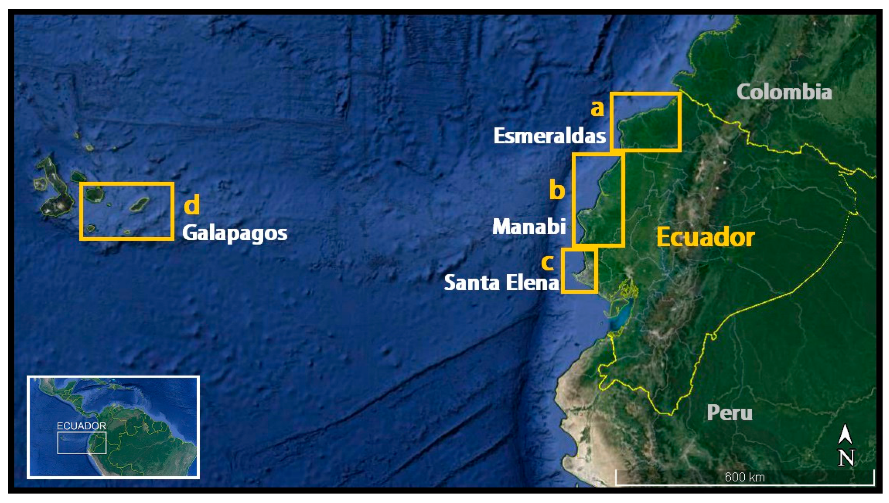
2.1. Study Area
2.2. Methods
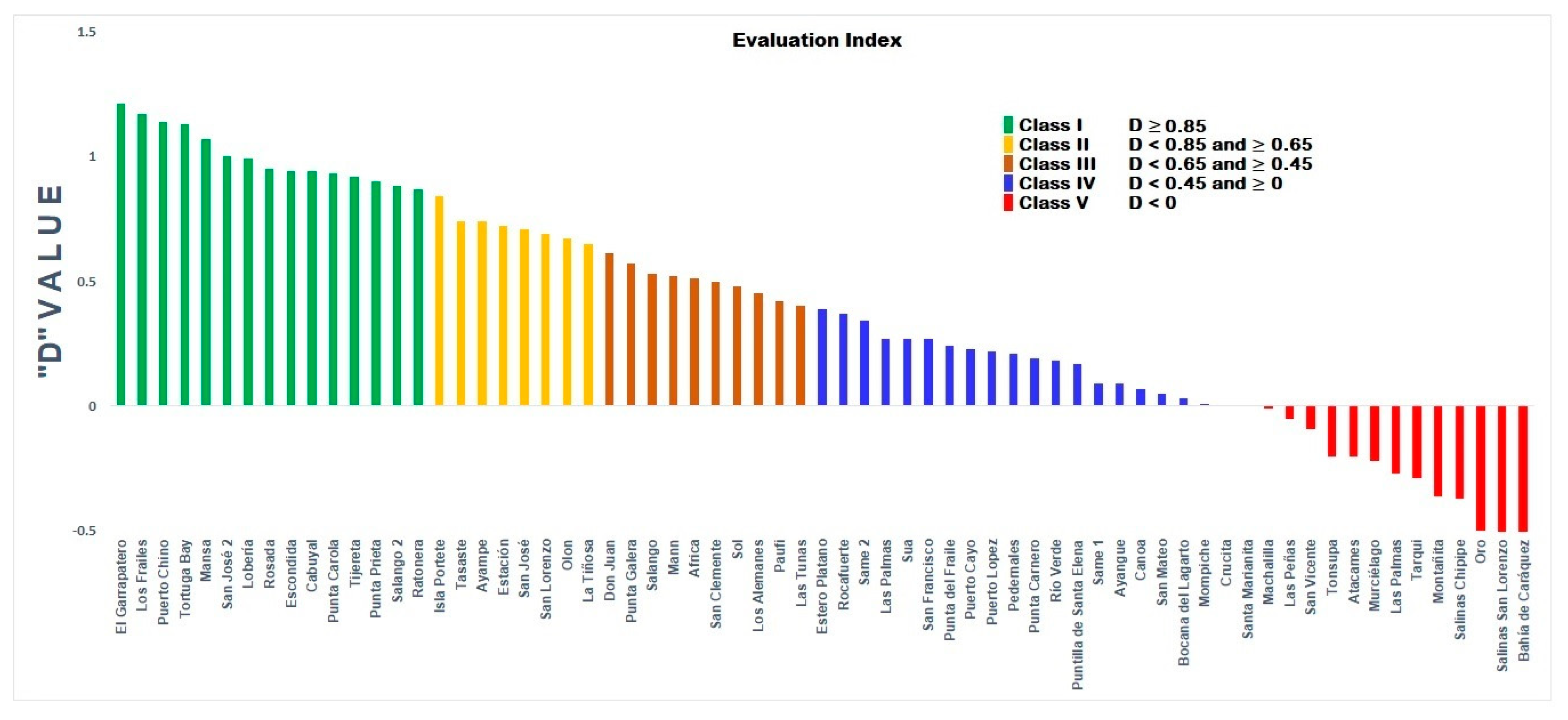
3. Results
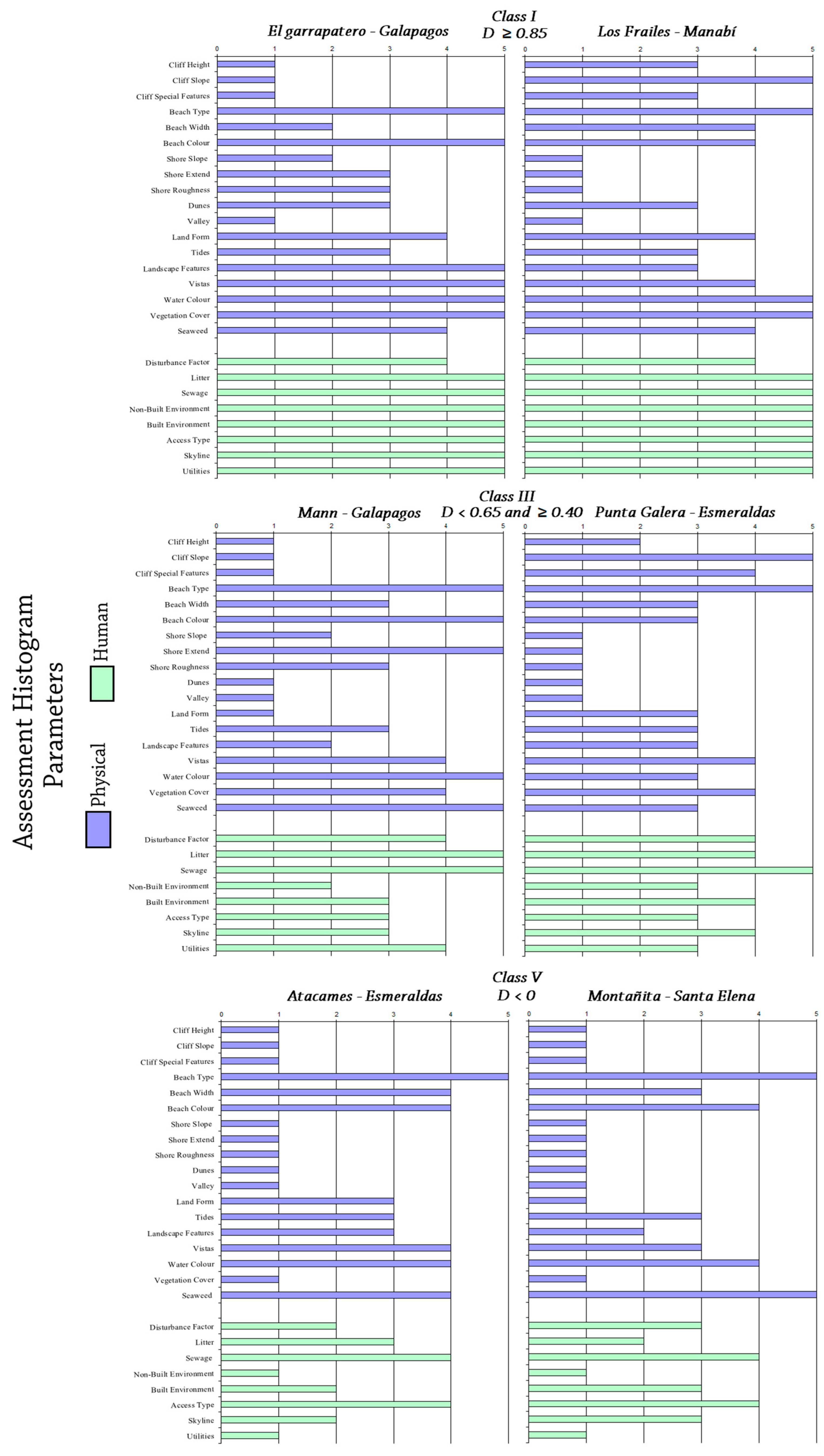
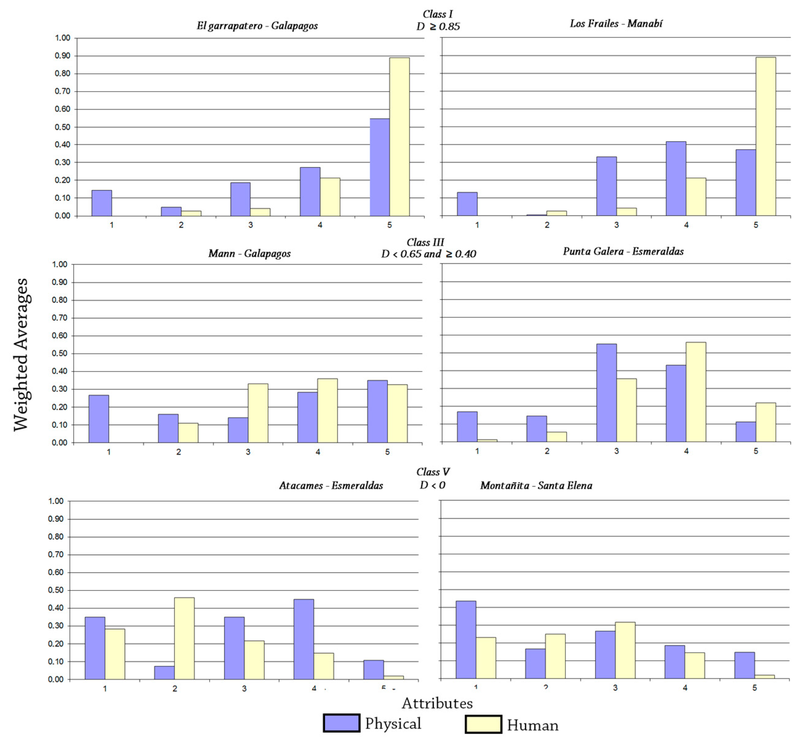
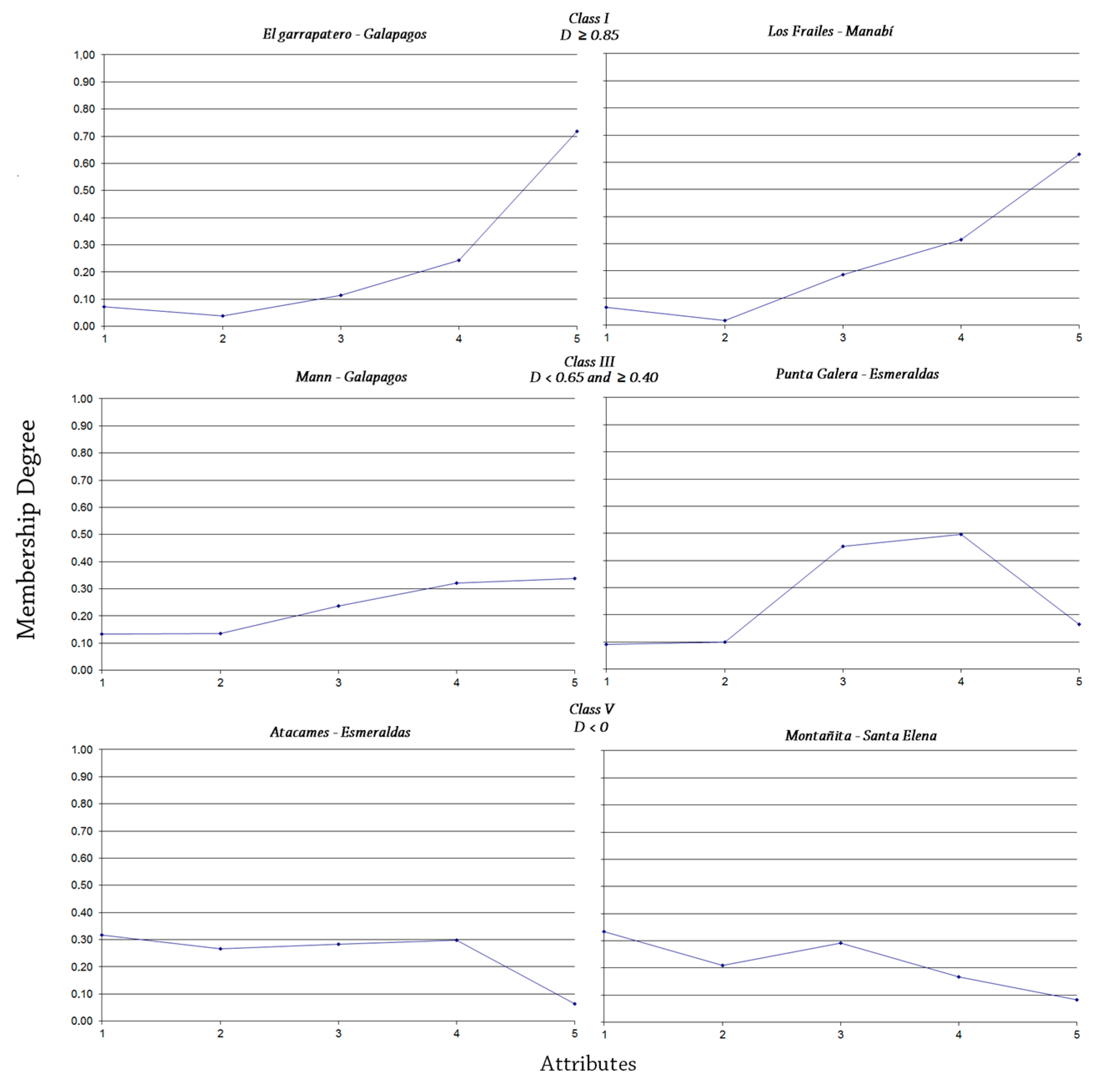
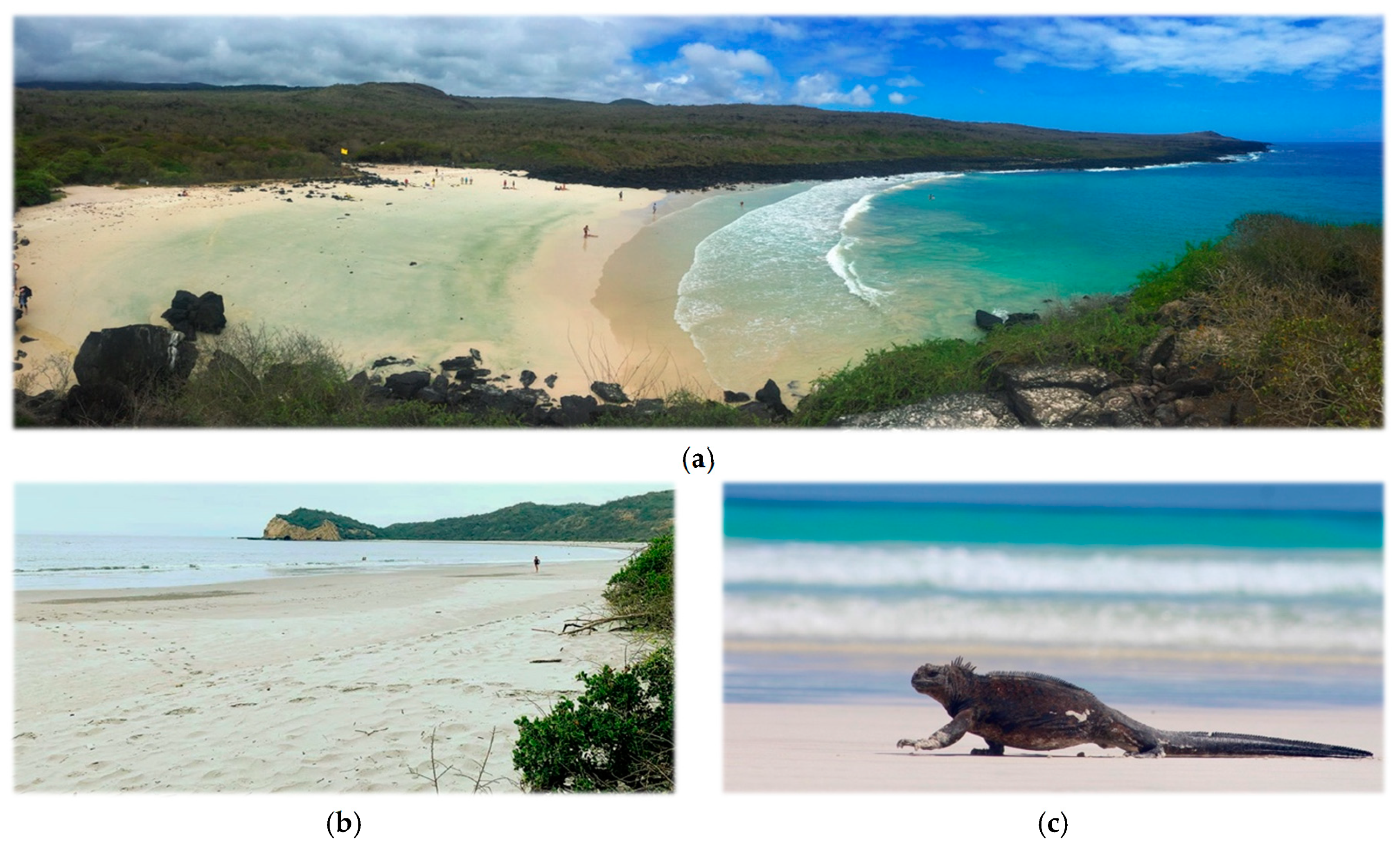
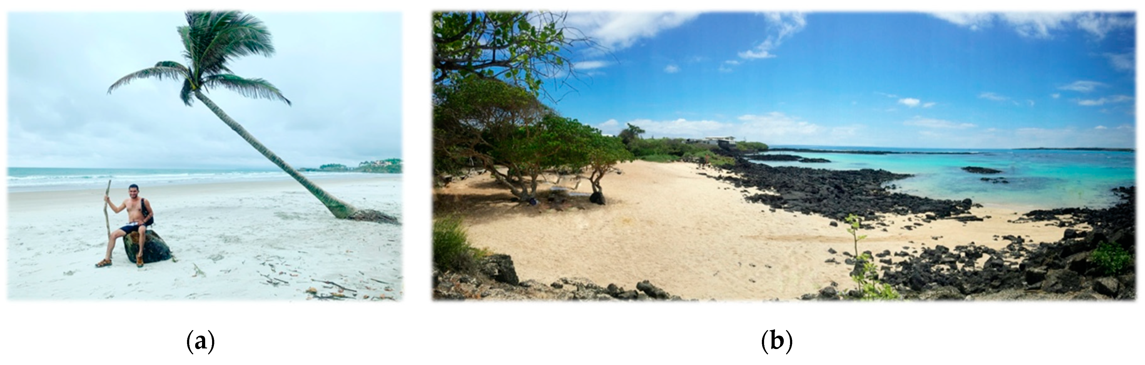
3.1. Class I
3.2. Class II
3.3. Class III
3.4. Class IV
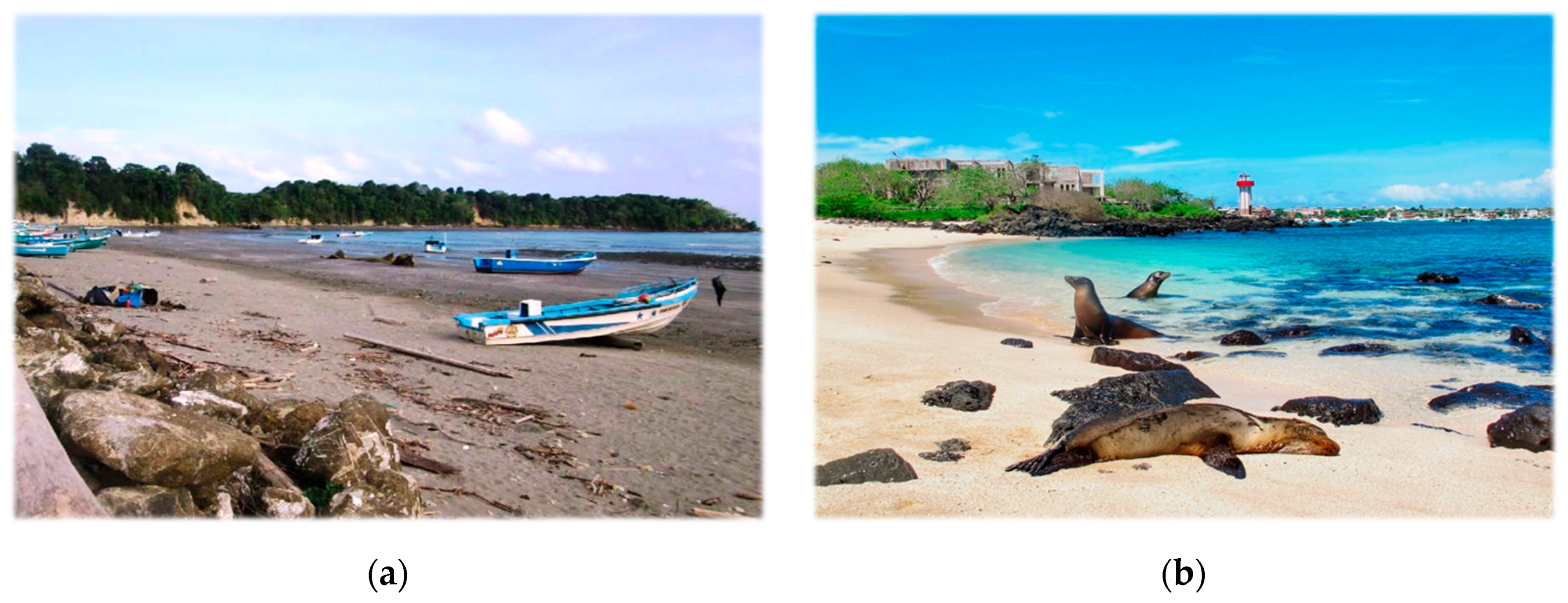
3.5. Class V
4. Discussion
4.1. Human Impacts
4.2. Management Issues
5. Conclusions
Author Contributions
Funding
Acknowledgments
Conflicts of Interest
References
- Rangel-Buitrago, N.; Williams, A.T.; Ergin, A.; Anfuso, G.; Micallef, A.; Pranzini, E. Coastal scenery: An introduction. In Coastal Scenery; Springer: Berlin/Heidelberg, Germany, 2019; pp. 1–16. [Google Scholar]
- UNWTO. UNWTO world tourism barometer and statistical annex, May 2019. UNWTO World Tour. Barom. 2019, 17, 1–40. [Google Scholar]
- UNWTO. UNWTO world tourism barometer and statistical annex, Jan 2020. UNWTO World Tour. Barom. 2020, 18, 1–6. [Google Scholar]
- Klein, Y.L.; Osleeb, J.P.; Viola, M.R. Tourism-generated earnings in the coastal zone: A regional analysis. J. Coast. Res. 2004, 1080–1088. [Google Scholar]
- Ministerio de Turismo del Ecuador—MINTUR. Rendición de Cuentas 2018; Ministerio de Economía y Finanzas: Quito, Ecuador, 2019.
- Ministerio de Turismo del Ecuador—MINTUR. Perfil de Turismo Internacional 2017; Alvaracín, M., Gallegos, F., Lafuente, F., Eds.; Ministerio de Economía y Finanzas: Quito, Ecuador, 2018.
- Mestanza-Ramón, C.; Sanchez Capa, M.; Figueroa Saavedra, H.; Rojas Paredes, J. Integrated coastal zone management in continental ecuador and galapagos islands: Challenges and opportunities in a changing tourism and economic context. Sustainability 2019, 11, 6386. [Google Scholar] [CrossRef] [Green Version]
- Maestro, M.; Pérez-Cayeiro, M.L.; Chica-Ruiz, J.A.; Reyes, H. Marine protected areas in the 21st century:Current situation and trends. Ocean Coast. Manag. 2019, 171, 28–36. [Google Scholar] [CrossRef]
- Dodds, R.; Kelman, I. How climate change is considered in sustainable tourism policies: A case of the mediterranean islands of malta and mallorca. Tour. Rev. Int. 2008, 12, 57–70. [Google Scholar] [CrossRef]
- Houston, J.R. The value of Florida beaches. American Shore & Beach Preservation Association. 2013, 81, 4–11. [Google Scholar]
- Ousby, I. The Englishman’s England: Taste, Travel and the Rise of Tourism; Cambridge University Press: Cambridge, UK, 1990; ISBN 0521373743. [Google Scholar]
- Alipour, H.; Olya, H.G.T.; Maleki, P.; Dalir, S. Behavioral responses of 3S tourism visitors: Evidence from a Mediterranean Island destination. Tour. Manag. Perspect. 2020, 33, 100624. [Google Scholar] [CrossRef]
- Rangel-Buitrago, N.; Correa, I.D.; Anfuso, G.; Ergin, A.; Williams, A.T. Assessing and managing scenery of the Caribbean Coast of Colombia. Tour. Manag. 2013, 35, 41–58. [Google Scholar] [CrossRef]
- Williams, A.T.; Rangel-Buitrago, N.G.; Anfuso, G.; Cervantes, O.; Botero, C.M. Litter impacts on scenery and tourism on the Colombian north Caribbean coast. Tour. Manag. 2016, 55, 209–224. [Google Scholar] [CrossRef]
- Rutty, M.; Scott, D. Differential climate preferences of international beach tourists. Clim. Res. 2013, 57, 259–269. [Google Scholar] [CrossRef]
- Ergin, A.; Karaesmen, E.; Micallef, A.; Williams, A.T. A new methodology for evaluating coastal scenery: Fuzzy logic systems. Area 2004, 36, 367–386. [Google Scholar] [CrossRef]
- Williams, A. Definitions and Typologies of Coastal Tourism beach Destinations. In Disappearing Destinations: Climate Change and Future Challenges for Coastal Tourism; Andrew, J., Phillips, M., Eds.; CABI: Wallingford, UK, 2009; p. 47. ISBN 9781845935481. [Google Scholar]
- Williams, A.; Micallef, A. Beach Management: Principles and Practice; Routledge: Abingdon-on-Thames, UK, 2009; ISBN 1849770034. [Google Scholar]
- Mooser, A.; Anfuso, G.; Mestanza, C.; Williams, A. Management implications for the most attractive scenic sites along the andalusia coast (SW Spain). Sustainability 2018, 10, 1328. [Google Scholar] [CrossRef] [Green Version]
- Anfuso, G.; Williams, A.T.; Casas Martínez, G.; Botero, C.M.; Cabrera Hernández, J.A.; Pranzini, E. Evaluation of the scenic value of 100 beaches in Cuba: Implications for coastal tourism management. Ocean Coast. Manag. 2017, 142, 173–185. [Google Scholar] [CrossRef]
- Mestanza, C.; Piccardi, M.; Pranzini, E. Coastal erosion management at Callao (Peru) in the 17th and 18th centuries: The first groin field in South America? Water 2018, 10, 891. [Google Scholar] [CrossRef] [Green Version]
- Instituto Oceanográfico de la Armada del Ecuador-INOCAR. Derrotero de la Costa Continental e Insular del Ecuador; Proaño, M., Ed.; INOCAR: Guayaquil, Ecuador, 2011. [Google Scholar]
- Dirección del Parque Nacional Galápagos. Plan de Manejo de las Áreas Protegidas de Galápagos para el BUEN VIVIR; Izurieta, A., Tapia, W., Mosquera, G., Chamorro, S., Eds.; UN environment programme: Puerto Ayora, Ecuador, 2014. [Google Scholar]
- Geist, D.J.; Snell, H.; Snell, H.; Goddard, C.; Kurz, M.D. A Paleogeographic Model of the Galápagos Islands and Biogeographical and Evolutionary Implications. In The Galápagos: A natural laboratory for the Earth Sciences; Harpp, K.S., Mittelstaedt, E., d’Ozouville, N., Graham, D.W., Eds.; Wiley Online Library: Washington, DC, USA, 2014; pp. 145–166. [Google Scholar]
- Jordá-Bordehore, L.; Toulkeridis, T.; Romero-Crespo, P.L.; Jordá-Bordehore, R.; García- Garizabal, I. Stability assessment of volcanic lava tubes in the Galápagos using engineering rock mass classifications and an empirical approach. Int. J. Rock Mech. Min. Sci. 2016, 89, 55–67. [Google Scholar] [CrossRef]
- Taylor, J.E.; Hardner, J.; Stewart, M. Ecotourism and economic growth in the Galapagos: An island economy-wide analysis. Environ. Dev. Econ. 2009, 14, 139–162. [Google Scholar] [CrossRef] [Green Version]
- Secretaria Nacional de Planificación y Desarrollo. Plan de Ordenamiento del Espacio Marino Costero; SEMPLADES: Quito, Ecuador, 2017.
- Ministerio del Ambiente del Ecuador – MAE. Guia de Parques 2014 - Parque Nacional Machalilla; MAE: Quito, Ecuador, 2014. [Google Scholar]
- Fines, K.D. Landscape evaluation—A research project in East Sussex: Rejoinder to critique by D. M. Brancher. Reg. Stud. 1969, 3, 219. [Google Scholar] [CrossRef]
- Linton, D.L. The assessment of scenery as a natural resource. Scott. Geogr. Mag. 1968, 84, 219–238. [Google Scholar] [CrossRef]
- Penning-Rowsell, E.C. Fluctuating fortunes in gauging landscape value. Prog. Hum. Geogr. 1981, 5, 25–41. [Google Scholar] [CrossRef]
- Kaplan, R.; Kaplan, S. Humanscape: Environments for People; Humanscape: Environments for People; Duxbury Press: Pacific Grove, CA, USA, 1978; ISBN 9780878721634. [Google Scholar]
- British Council Report (BCR). Coastal Scenic Assessments at Selected Sites in Turkey, UK and Malta; Final Report; British Council Office: Ankara, Turkey; Valetta, Malta, 2003; p. 64. [Google Scholar]
- Patel, A. V Analytical structures and analysis of fuzzy PD controllers with multifuzzy sets having variable cross-point level. Fuzzy Sets Syst. 2002, 129, 311–334. [Google Scholar] [CrossRef]
- Ergin, A.; Williams, A.T.; Micallef, A. Coastal scenery: Appreciation and evaluation. J. Coast. Res. 2006, 958–964. [Google Scholar] [CrossRef]
- Ullah, Z.; Johnson, D.; Micallef, A.; Williams, A.T. Coastal scenic assessment: Unlocking the potential for coastal tourism in rural Pakistan via Mediterranean developed techniques. J. Coast. Conserv. 2010, 14, 285–293. [Google Scholar] [CrossRef] [Green Version]
- Williams, A.T.; Micallef, A.; Anfuso, G.; Gallego-Fernandez, J.B. Andalusia, Spain: An Assessment of Coastal Scenery. Landsc. Res. 2012, 37, 327–349. [Google Scholar] [CrossRef]
- Anfuso, G.; Williams, A.T.; Hernández, J.A.C.; Pranzini, E. Coastal scenic assessment and tourism management in western Cuba. Tour. Manag. 2014, 42, 307–320. [Google Scholar] [CrossRef]
- Rangel-Buitrago, N. Coastal Scenery: Evaluation and Management; Springer: Berlin/Heidelberg, Germany, 2018; Volume 26, ISBN 3319788787. [Google Scholar]
- Williams, A. Definitions and typologies of coastal tourism beach destinations. Disappearing Destin. Clim. Chang. Futur. challenges Coast. Tour. 2011, 47–66. [Google Scholar]
- Williams, A.T.; Sellers, V.; Phillips, M.R. An assessment of UK Heritage coasts in south Wales: JA Steers revisited. J. Coast. Res. 2007, 453–458. [Google Scholar]
- Mestanza, C.; Botero, C.M.; Anfuso, G.; Chica-Ruiz, J.A.; Pranzini, E.; Mooser, A. Beach litter in Ecuador and the Galapagos islands: A baseline to enhance environmental conservation and sustainable beach tourism. Mar. Pollut. Bull. 2019, 140, 573–578. [Google Scholar] [CrossRef]
- Vlachogianni, T.; Skocir, M.; Constantin, P.; Labbe, C.; Orthodoxou, D.; Pesmatzoglou, I.; Scannella, D.; Spika, M.; Zissimopoulos, V.; Scoullos, M. Plastic pollution on the Mediterranean coastline: Generating fit-for-purpose data to support decision-making via a participatory-science initiative. Sci. Total Environ. 2020, 711, 135058. [Google Scholar] [CrossRef] [PubMed]
- Krelling, A.P.; Williams, A.T.; Turra, A. Differences in perception and reaction of tourist groups to beach marine debris that can influence a loss of tourism revenue in coastal areas. Mar. Policy 2017, 85, 87–99. [Google Scholar] [CrossRef]
- Asensio-Montesinos, F.; Anfuso, G.; Ramírez, M.O.; Smolka, R.; Sanabria, J.G.; Enríquez, A.F.; Arenas, P.; Bedoya, A.M. Beach litter composition and distribution on the Atlantic coast of Cádiz (SW Spain). Reg. Stud. Mar. Sci. 2020, 34, 101050. [Google Scholar] [CrossRef]
- Caviedes, V.; Arenas-Granados, P.; Barragán-Muñoz, J.M. Regional public policy for Integrated Coastal Zone Management in Central America. Ocean Coast. Manag. 2020, 186, 105114. [Google Scholar] [CrossRef]
- Milanés Batista, C.; Planas, J.A.; Pelot, R.; Núñez, J.R. A new methodology incorporating public participation within Cuba’s ICZM program. Ocean Coast. Manag. 2020, 186, 105101. [Google Scholar] [CrossRef]
- Barragán Muñoz, J.M. Progress of coastal management in Latin America and the Caribbean. Ocean Coast. Manag. 2020, 184, 105009. [Google Scholar] [CrossRef]
- Alexandrakis, G.; Manasakis, C.; Kampanis, N.A. Valuating the effects of beach erosion to tourism revenue. A management perspective. Ocean Coast. Manag. 2015, 111, 1–11. [Google Scholar] [CrossRef]
- Mestanza-Ramón, C.; Chica-Ruiz, J.A.; Anfuso, G.; Mooser, A.; Botero, C.M.; Pranzini, E. Tourism in Continental Ecuador and the Galapagos Islands: An Integrated Coastal Zone Management (ICZM) Perspective. Water 2020, 12, 1647. [Google Scholar] [CrossRef]
- Pazmiño Manrique, P.; Barragán, J.M.; García Sanabria, J. Progress on coastal management in ecuador (2007–2017). Environ. Sci. Policy 2018, 90, 135–147. [Google Scholar] [CrossRef]
- Mestanza-Ramón, C.; Pranzini, E.; Anfuso, G.; Botero, M.C.; Chica-Ruiz, A.J.; Mooser, A. An attempt to characterize the “3S” (Sea, Sun, and Sand) Parameters: Application to the galapagos islands and continental ecuadorian beaches. Sustainability 2020, 12, 2468. [Google Scholar] [CrossRef] [Green Version]
- Zambrano-Monserrate, M.A.; Silva-Zambrano, C.A.; Ruano, M.A. The economic value of natural protected areas in Ecuador: A case of Villamil Beach National Recreation Area. Ocean Coast. Manag. 2018, 157, 193–202. [Google Scholar] [CrossRef]


| Nº | Name | Province | Type | “D” | Class |
|---|---|---|---|---|---|
| 1 | Escondida *,(1) | Esmeraldas | Remote | 0.94 | I |
| 2 | Isla Portete | Rural | 0.84 | II | |
| 3 | Punta Galera *,(1) | Rural | 0.57 | III | |
| 4 | Africa | Remote | 0.51 | III | |
| 5 | Paufi | Rural | 0.42 | III | |
| 6 | Estero Platano *,(1) | Village | 0.39 | IV | |
| 7 | (Rocafuerte) | Rural | 0.37 | IV | |
| 8 | Same 2 | Remota | 0.34 | IV | |
| 9 | Las Palmas | Urbana | 0.27 | IV | |
| 10 | Sua | Urbana | 0.27 | IV | |
| 11 | San Francisco *,(1) | Village | 0.27 | IV | |
| 12 | Río Verde | Village | 0.18 | IV | |
| 13 | Same 1 | Village | 0.09 | IV | |
| 14 | Bocana del Lagarto | Village | 0.03 | IV | |
| 15 | Mompiche | Village | 0.01 | IV | |
| 16 | Las Peñas | Village | −0.05 | V | |
| 17 | Tonsupa | Urbana | −0.20 | V | |
| 18 | Atacames | Urbana | −0.20 | V | |
| 19 | Las Palmas | Urbana | −0.27 | V | |
| 20 | El Garrapatero *,(2) | Galapagos | Remote | 1.21 | I |
| 21 | Puerto Chino *,(2) | Remote | 1.14 | I | |
| 22 | Tortuga Bay *,(2) | Remote | 1.13 | I | |
| 23 | Mansa *,(2) | Remote | 1.07 | I | |
| 24 | Lobería *,(2) | Remote | 0.99 | I | |
| 25 | Punta Carola *,(2) | Remote | 0.93 | I | |
| 26 | Tijereta *,(2) | Remote | 0.92 | I | |
| 27 | Ratonera *,(2) | Village | 0.87 | I | |
| 28 | Estación *,(2) | Village | 0.72 | II | |
| 29 | Mann *,(2) | Village | 0.52 | III | |
| 30 | Los Alemanes *,(2) | Village | 0.45 | III | |
| 31 | Oro *,(2) | Urban | −0.50 | V | |
| 32 | Los Frailes *,(3) | Manabi | Remota | 1.17 | I |
| 33 | San José 2 *,(4) | Remota | 1.00 | I | |
| 34 | Cabuyal | Remota | 0.94 | I | |
| 35 | Punta Prieta | Remota | 0.90 | I | |
| 36 | Salango 2 *,(3) | Remota | 0.88 | I | |
| 37 | Tasaste | Rural | 0.74 | II | |
| 38 | Ayampe | Village | 0.74 | II | |
| 39 | San José *,(4) | Rural | 0.71 | II | |
| 40 | San Lorenzo *,(4) | Village | 0.69 | II | |
| 41 | La Tiñosa | Rural | 0.65 | II | |
| 42 | Don Juan | Rural | 0.61 | III | |
| 43 | Salango | Village | 0.53 | III | |
| 44 | San Clemente | Rural | 0.50 | III | |
| 45 | Sol | Rural | 0.48 | III | |
| 46 | Las Tunas | Rural | 0.40 | III | |
| 47 | Punta (del Fraile) | Village | 0.24 | IV | |
| 48 | Puerto Cayo | Village | 0.23 | IV | |
| 49 | Puerto Lopez | Urbana | 0.22 | IV | |
| 50 | Pedernales | Urbana | 0.21 | IV | |
| 51 | Canoa | Village | 0.07 | IV | |
| 52 | San Mateo | Village | 0.05 | IV | |
| 53 | Crucita | Urbana | 0.00 | IV | |
| 54 | Santa Marianita | Village | 0.00 | IV | |
| 55 | Machalilla | Village | −0.01 | V | |
| 56 | San Vicente | Urbana | −0.09 | V | |
| 57 | Murciélago | Urbana | −0.22 | V | |
| 58 | Tarqui | Urbana | −0.29 | V | |
| 59 | Bahía de Caráquez | Urbana | −0.57 | V | |
| 60 | Rosada *,(5) | Santa Elena | Rural | 0.95 | I |
| 61 | Olon | Village | 0.67 | II | |
| 62 | Punta Carnero | Urbana | 0.19 | IV | |
| 63 | Puntilla de Santa Elena *,(6) | Rural | 0.17 | IV | |
| 64 | Ayangue *,(5) | Village | 0.09 | IV | |
| 65 | Montañita | Urbana | −0.36 | V | |
| 66 | Salinas Chipipe | Urbana | −0.37 | V | |
| 67 | Salinas San Lorenzo | Urbana | −0.52 | V |
| No | Parameters | Rating | ||||||
|---|---|---|---|---|---|---|---|---|
| 1 | 2 | 3 | 4 | 5 | ||||
| Physical | 1 | CLIFF | Height (H) | Absent | 5 m ≤ H < 30 m | 30 m ≤ H < 60 m | 60 m ≤ H < 90 m | H ≥ 90 m |
| 2 | Slope | <45° | 45°–60° | 60°–75° | 75°–85° | circa vertical | ||
| 3 | Features * | Absent | 1 | 2 | 3 | Many (>3) | ||
| 4 | Type | Absent | Mud | Cobble/Boulder | Pebble/Gravel | Sand | ||
| 5 | BEACH FACE | Width (W) | Absent | W < 5 m or W >100 m | 5 m ≤ W < 25 m | 25 m ≤ W < 50 m | 50 m ≤ W ≤ 100 m | |
| 6 | Color | Absent | Dark | Dark tan | Light tan/bleached | White/gold | ||
| 7 | Slope | Absent | <5° | 5°–10° | 10°–20° | 20°–45° | ||
| 8 | ROCKY SHORE | Extent | Absent | <5 m | 5–10 m | 10–20 m | >20 m | |
| 9 | Roughness | Absent | Distinctly jagged | Deeply pitted and/or irregular | Shallow pitted | Smooth | ||
| 10 | DUNES | Absent | Remnants | Fore-dune | Secondary ridge | Several | ||
| 11 | VALLEY | Absent | Dry valley | (<1 m) Stream | (1–4 m) Stream | River/limestone gorge | ||
| 12 | SKYLINE LANDFORM | Not visible | Flat | Undulating | Highly undulating | Mountainous | ||
| 13 | TIDES | Macro (>4 m) | - | Meso (2–4 m) | - | Micro (<2 m) | ||
| 14 | COASTAL LANDSCAPE FEATURES ** | None | - | 2 | 3 | >3 | ||
| 15 | VISTAS | Open on one side | Open on two sides | - | Open on three sides | Open on four sides | ||
| 16 | WATER COLOUR & CLARITY | Muddy brown/grey | Milky blue/green/opaque | Green/grey/blue | Clear blue//dark blue | Very clear turquoise | ||
| 17 | NATURAL VEGETATION COVER | Bare (<10% vegetation only) | Scrub/garigue (marron/gorse, bramble, etc.) | Wetlands/meadow | Coppices, marquis (±mature trees) | Varity of mature trees/mature natural cover | ||
| 18 | VEGETATION DEBRIS1 | Continuous (>50 cm high) | Full strand line | Single accumulation | Few scattered items | None | ||
| Human | 19 | NOISE DISTURBANCE | Intolerable | Tolerable | - | Little | None | |
| 20 | LITTER | Continuous accumulations | Full strand line | Single accumulation | Few scattered items | Virtually absent | ||
| 21 | SEWAGE DISCHARGE EVIDENCE | Sewage evidence | - | Same evidence (1–3 items) | - | No evidence of sewage | ||
| 22 | NON_BUILT ENVIRONMENT | None | - | Hedgerow/terracing/monoculture | - | Field mixed cultivation ± trees/natural | ||
| 23 | BUILT ENVIRONMENT *** | Heavy Industry | Heavy tourism and/or urban | Light tourism and/or urban and/or sensitive | Sensitive tourism and/or urban | Historic and/or none | ||
| 24 | ACCESS TYPE | No buffer zone/heavy traffic | No buffer zone/light traffic | - | Parking lot visible from coastal area | Parking lot not visible from coastal area | ||
| 25 | SKYLINE | Very unattractive | - | Sensitively designed high/low | Very sensitively designed | Natural/historic features | ||
| 26 | UTILITIES **** | >3 | 3 | 2 | 1 | None | ||
© 2020 by the authors. Licensee MDPI, Basel, Switzerland. This article is an open access article distributed under the terms and conditions of the Creative Commons Attribution (CC BY) license (http://creativecommons.org/licenses/by/4.0/).
Share and Cite
Mestanza-Ramón, C.; Anfuso, G.; Chica-Ruiz, J.A.; Mooser, A.; Botero, C.M.; Pranzini, E. Coastal Scenic Evaluation of Continental Ecuador and Galapagos Islands: Human Impacts and Management Issues. J. Mar. Sci. Eng. 2020, 8, 468. https://doi.org/10.3390/jmse8060468
Mestanza-Ramón C, Anfuso G, Chica-Ruiz JA, Mooser A, Botero CM, Pranzini E. Coastal Scenic Evaluation of Continental Ecuador and Galapagos Islands: Human Impacts and Management Issues. Journal of Marine Science and Engineering. 2020; 8(6):468. https://doi.org/10.3390/jmse8060468
Chicago/Turabian StyleMestanza-Ramón, Carlos, Giorgio Anfuso, J. Adolfo Chica-Ruiz, Alexis Mooser, Camilo M. Botero, and Enzo Pranzini. 2020. "Coastal Scenic Evaluation of Continental Ecuador and Galapagos Islands: Human Impacts and Management Issues" Journal of Marine Science and Engineering 8, no. 6: 468. https://doi.org/10.3390/jmse8060468