Article

Digital Technologies for the Sustainable Development of the Accessible Underwater Cultural Heritage Sites

1
Department of Mechanical, Energy, and Management Engineering (DIMEG), University of Calabria, 87036 Arcavacata di Rende, CS, Italy
2
Department of Biology, Ecology and Earth Sciences (DiBEST), University of Calabria, 87036 Arcavacata di Rende, CS, Italy
3
3D Research s.r.l., Ponte P. Bucci, 45/C, 87036 Arcavacata di Rende, CS, Italy
4
Ephorate of Underwater Antiquities—Ministry of Culture and Sports, Miniak 12, 11741 Athens, Greece
5
Atlantis Consulting S.A., 57001 Thermi, Thessaloniki, Greece
6
Regional Development Fund-Region of Thessaly, 41110 Larissa, Greece
*
Author to whom correspondence should be addressed.
J. Mar. Sci. Eng. 2020, 8(11), 955; https://doi.org/10.3390/jmse8110955
Submission received: 19 October 2020 / Revised: 18 November 2020 / Accepted: 19 November 2020 / Published: 23 November 2020
(This article belongs to the Special Issue Advanced Technologies for Maritime and Underwater Archaeology)

Abstract

:
In recent years, the development in digital technologies such as Augmented Reality (AR) and Virtual Reality (VR) has evolved rapidly. These technologies are currently in the process of creating driving change in the Cultural and Creative Industries (CCIs), representing innovative means to share information, facilitating access and increasing the value and public awareness on Cultural and Natural Heritage. This is particularly relevant for underwater environments, where the most interesting cultural and naturalistic sites are accessible only to scuba divers, or not accessible at all, due to depth and/or environmental constraints. In addition, in underwater sites, guided diving tours are carried out by professionals that usually describe the area to be visited during the predive briefings; such step is needed due to the impossibility of underwater verbal communication without dedicated equipment, a practice very rarely adopted for recreational diving. So, these difficulties make it almost impossible to replicate under the sea, the guided tour approach that is usually offered in on-land museums. Considering such limitations, several technological applications are emerging to increase the accessibility underwater and enrich users’ experience both for divers and nondivers. This work aims to identify the potential of underwater sites (either cultural or natural) to support the development of sustainable tourism (economic, environmental, cultural and social) in the Mediterranean. Moreover, it focuses on supplying local/regional authorities and stakeholders with a multidisciplinary plan for managing Underwater Museums and Knowledge Centres, by promoting innovation in the diving industry and improving users’/tourists’ experience through value-added services and cutting-edge technologies.

1. Introduction

The cultural and naturalistic heritage that lies on the seabed around the world is an important resource that raises particular attention among tourists. Such interest is attributed to the sense of mystery that surrounds cultural and natural assets and the harmonic “symbiosis” between the artefacts and sea life.
Although the interest in the field of underwater cultural heritage (UCH) is growing, the difficulty in the enjoyment of underwater archaeological/historical assets is still remarkable. Hence, there is a need to utilize innovative solutions suitable to raise public awareness and knowledge towards such an important and emerging topic.
Cultural Heritage (CH) represents a very important aspect of our past, reflecting the historical/cultural development of populations over the centuries [1,2,3,4]. People/Tourists who travel to learn about unknown places and cultures, first search for museums to visit and/or Visitor Centres that can provide them relevant information. The growth in users’ demand in enjoying added value/innovative services and in visiting assets located at sea continuously increases, but there are still many limits for their full enjoyment.
In this direction, to meet users requests and with an attempt to provide them new ways that will satisfy and attract their curiosity, the need rose to exploit new technologies that make it accessible to the general public, resources lying on the seabed. In this respect, the research aims at improving the exploitation modality of UCH and disseminates related knowledge, making the underwater world available, accessible and suitable for all [3]. Such an approach raises awareness on the value of cultural assets and makes underwater archaeological sites enjoyable by everyone, both divers and nondivers (creating the same impact as on-land cultural sites). This is also in accordance with the UNESCO 2001 convention [5], which has among its fundamental pillars the raising of public awareness and the creation of tourism potential through the valorisation and protection of underwater natural and cultural heritage, preferably in situ.
Today’s technological progress provides several ways and options (mainly based on digital technologies) to enhance and extend the traditional museum exhibitions with different contents and solutions. These new technological approaches raise a great interest among visitors and, at the same time, offer many opportunities to convey information otherwise impossible to be presented through traditional exhibitions [6,7].
Different technological solutions that enable visitors to enjoy new ways of communication and interactive visualization are already available in many traditional museums. Particularly, Virtual Reality (VR) and Augmented Reality (AR) have been used on several occasions for allowing users/tourists to explore and get educated on cultural heritage [8,9]. These applications basically assemble visual technologies, which put the image at the centre of the communication, with interactive technologies, demanding users to act and choose. Various embodiments can be used, each characterized by the type of devices, the user workspace and the provided levels of immersion, interaction and presence. VR has been used for exploring the digital replica of archaeological finds [10], complex reality-based 3D models [11] or for creating interactive and immersive experiences in museums to increase visitor engagement and education [12]. As reported in [13], there are still various open issues related to the integration of digital technologies into the exhibition space of traditional museums although it has been proved from the experiences of visitors that it improves knowledge and interest in cultural heritage.
Even if VR technologies have proven their effectiveness in increasing the value of cultural heritage, fewer applications have been developed for underwater cultural and naturalistic sites, due to various constraints, i.e., environmental conditions [14,15,16,17,18,19,20,21].
At submerged sites, divers often suffer from low visibility conditions due to water turbidity and biological colonization. This leads to a reduced perception of the surrounding environment and a higher probability (for divers) to lose the sense of direction. In addition, the sea progressively transforms the cultural assets, both shipwrecks and ancient ruins that lie on the seabed. The mechanical action of the seawater, in conjunction with various changing environmental parameters, and the biological colonization of the marine flora and fauna that grow over the surface of the submerged artefacts, make materials (and more generally everything) that lie on the seabed, drastically different, or even completely unrecognizable from their original appearance [22,23,24,25,26,27,28,29,30,31,32,33,34].
So, in this regard, the presentation of submerged sites through the use of new technologies requires more resources and efforts (financially, labour-wise and tech-wise) since much of the required work must first be carried out underwater. For example, if the scope is to explore a digital replica of an underwater cultural site in VR, an underwater 3D survey of the archaeological remains has to be accomplished in order to create a realistic virtual scenario [8,9,10,11,12,13,14,15,16,17,18,19,20,21,22,23,24,25,26,27,28].
Some details and specific methods useful for realistic 3D modelling and VR presentation of underwater archaeological assets were presented in recent studies [14,15,16,17,18,26,28] along with the virtual diving exploration of some shipwrecks and further underwater sites. The results achieved in these studies allow users to live an entertaining and interdisciplinary learning experience by receiving archaeological, historical and biological information through several points of interest (POIs), also supported by a virtual dive buddy that guides during the exploration of the digital replica of a submerged site.
Such solution makes visible to people/users that are not used to or unable to dive, or most other stakeholders (e.g., museum managers), that AR and VR have a huge potential since they can reveal the original shape and beauty of the underwater cultural assets to even when they are deeply transformed by the action of the sea [8,9,10,11,12,13,14,15,16,17,18,26,28].
The main objective of this work is based on the design of exhibitions and Information Centres, so-called KAC (Knowledge Awareness Centre), where advanced digital technologies (i.e., Virtual Reality, Mixed/Augmented Reality, immersive visualization techniques, etc.) merge with traditional museum management practices and with dissemination/communication activities of recreational facilities, such as Visitor Centres and InfoPoints.
The management model of a KAC and all the activities linked with selected underwater archaeological sites will be presented.
Based on achieved results, users’ experience and visitor satisfaction survey, KACs will prove to be very efficient facilities in enhancing traditional museum exhibitions. This approach makes KACs a valuable tool for providing a wider range of solutions to both the local community/operators (i.e., diving centres, maritime and tourism industries, museums, etc.) and incoming tourists. Based on a common methodological approach, adopted for measuring incoming tourist/users satisfaction, the KACs also proved to be a key factor in defining a sustainable and responsible model for tourism development, based on the management, protection and promotion of underwater sites (both cultural and natural) [1,2,3,4,5,6,35,36,37,38,39,40].
Tourists, visiting the area near an Accessible UCH site, have the opportunity to appreciate the archaeological artefacts using the VR Diving systems deployed in the KACs, and also, for diving enthusiasts, guided tours are offered along dedicated underwater trails by using innovative AR underwater systems [41,42,43,44,45].
This work is being developed within the BLUEMED project, funded by the European Interreg MED modular project, implemented under programme’s priority axis 3 (natural and cultural resources) and specific objective 3.1 (sustainable tourism), with the selection of several major underwater pilot areas located in Italy, Greece and Croatia. The overall objective of BLUEMED focused on: “Align/Integrate regional development policies, plans and management practices for Underwater Museums and Diving Parks for a tourism promotion of underwater natural and cultural heritage, in accordance with the principles of Sustainable, Responsible, Blue growth”.
In particular, the paper presents the results achieved following the realization of two (out of the four developed in BLUEMED) KACs located in Greece and the recent surveys of attendances and experiences, resulting from a formal evaluation that has involved the first visitors/users. More specifically, this work includes an overview of the steps pursued for the realization of the KACs in BLUEMED with particular regards to information on the current status (i.e., status of operation, location, provided equipment, management model, users rating and experience, etc.) of the two KACs designed in the Greek BLUEMED pilot sites.

2. The Model of the Knowledge Awareness Centre

The management model for BLUEMED KACs has been focused on their sustainable operation to enhance the practices in the Accessible UCH sites and to provide the local communities and visitors with value-added services, through exhibitions of both physical and virtual content of a high technological quality. What is more, for the underwater artefacts to be integrated in their cultural and natural environments and therefore be educational for visitors, a detailed exhibitions planning was designed and executed by project partners.
A collection of initial feedback has been conducted in collaboration with local stakeholders of the cultural heritage sector (i.e., museologists, underwater archaeologists and environmentalists, ministers and local politicians) to identify and assess the planning of the KACs and the setting of the exhibitions and related issues.
The overall goal was focused on sustainable tourism development in MED areas [3] and although legislation, operation planning, staffing and facilities differ from country to country, all the KACs, within the BLUEMED project (i.e., KACs in Italy, Croatia and Greece), aimed to raise awareness on the value of the cultural and natural heritage lying under the sea surface.
Based on the collected feedback and after searching for existing good practices and norms [2,4,5,20,21,22,35,36,37,38,39,40], BLUEMED project partners identified the essential elements for managing and creating exhibit interactive solutions, by introducing innovative tools and equipment usable in KACs. So, starting from a thorough analysis of existing models, a new management model has been developed, trying to meet the changing needs of visitors and to understand how they could interact with such innovative facilities and related technological solutions. In addition, thanks to users’ experience and considering their satisfaction rate on what a typical exhibition may represent for them, KACs have been planned and implemented by merging the traditional exhibition practices with the most innovative ones. The new centres focus on practices in which the cutting-edge technologies (such as Virtual Reality, Mixed/Augmented Reality, immersive visualization techniques, man-machine interaction tools and systems, etc.) meet with the communication, entertainment and educational activities but with a greater user engagement [14,15,16,17,18,26,28,41,42,43].
In such a way, exhibitions in KACs, based on the first feedback received, appeared more understandable and enjoyable, encouraging interaction among users thanks to the introduction of the innovative solutions and offered activities. Particularly, the visitor experience outside of the “wet” environment is showing significant advantages, especially in presenting underwater sites that are inaccessible to the large public (i.e., people who do not like diving or are unable to do it). So, the virtual tools in the KACs are not limited to entertain users but have a pedagogical value, by providing additional information about the historical, biological, archaeological context [1,2,3,6,7,30,31,32,33,34,35,36,37,38].
Besides, the KACs management model in Italy and Croatia also shows that all the activities connected to an underwater site (diving excursions, bookings, departure/arrival, etc.) can be managed by the KACs themselves. The management model in Greece is different as the management of the underwater sites is undertaken by the Archaeological Service while the management of the KACs is at the responsibility of the municipal authorities. In any case, tourists that choose to visit a KAC will be also able to enjoy and take part in guided tours organized in dedicated underwater trails (i.e., Underwater Museums) by using the AR Diving system developed in the context of the project.

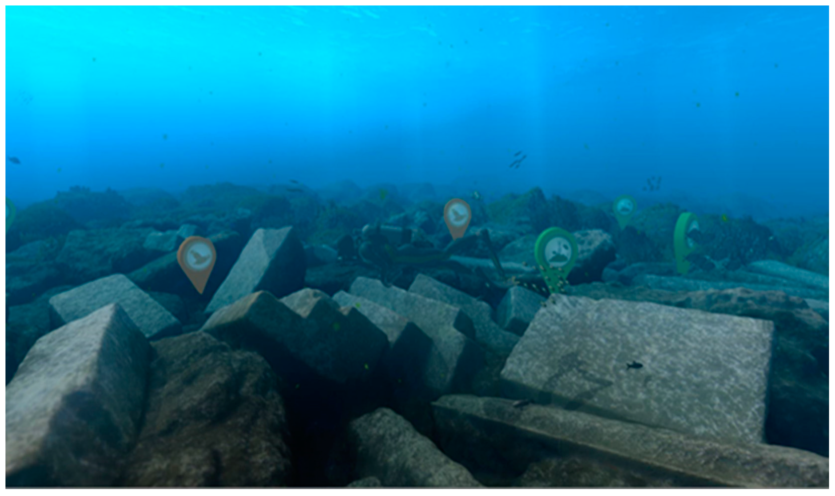
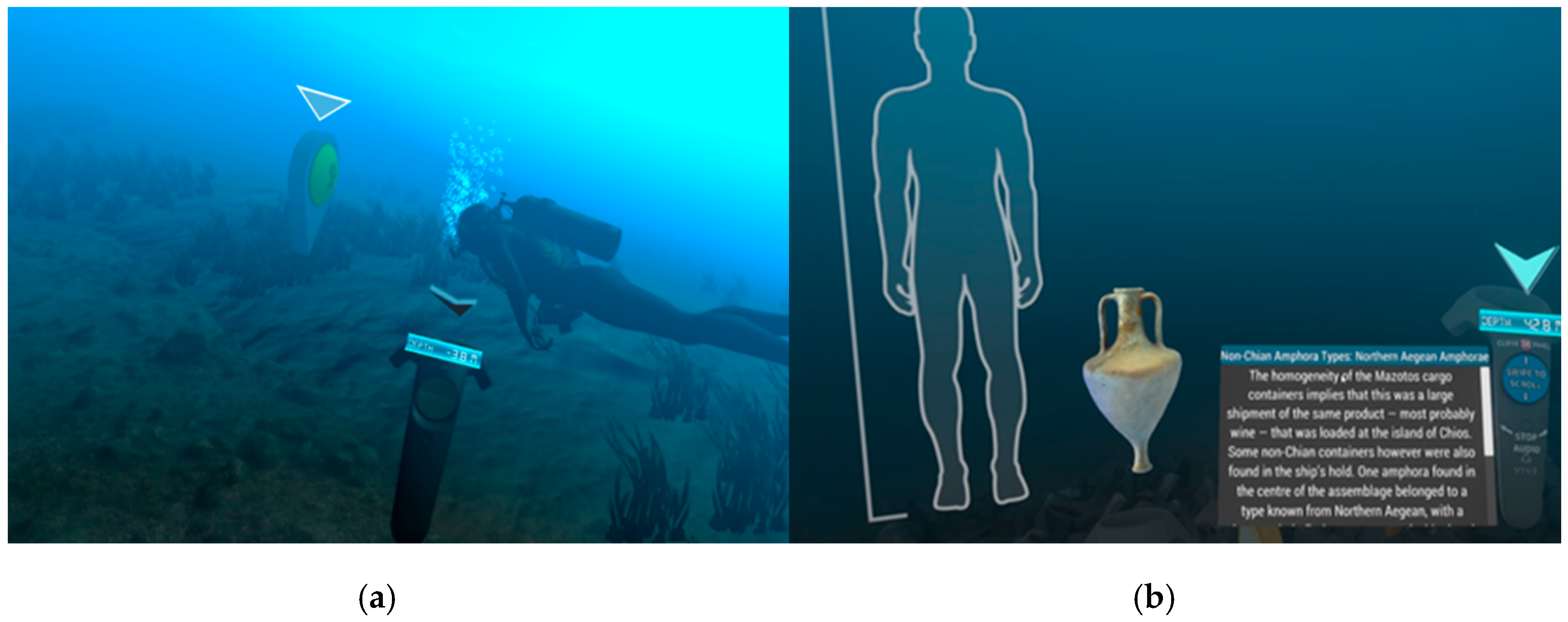
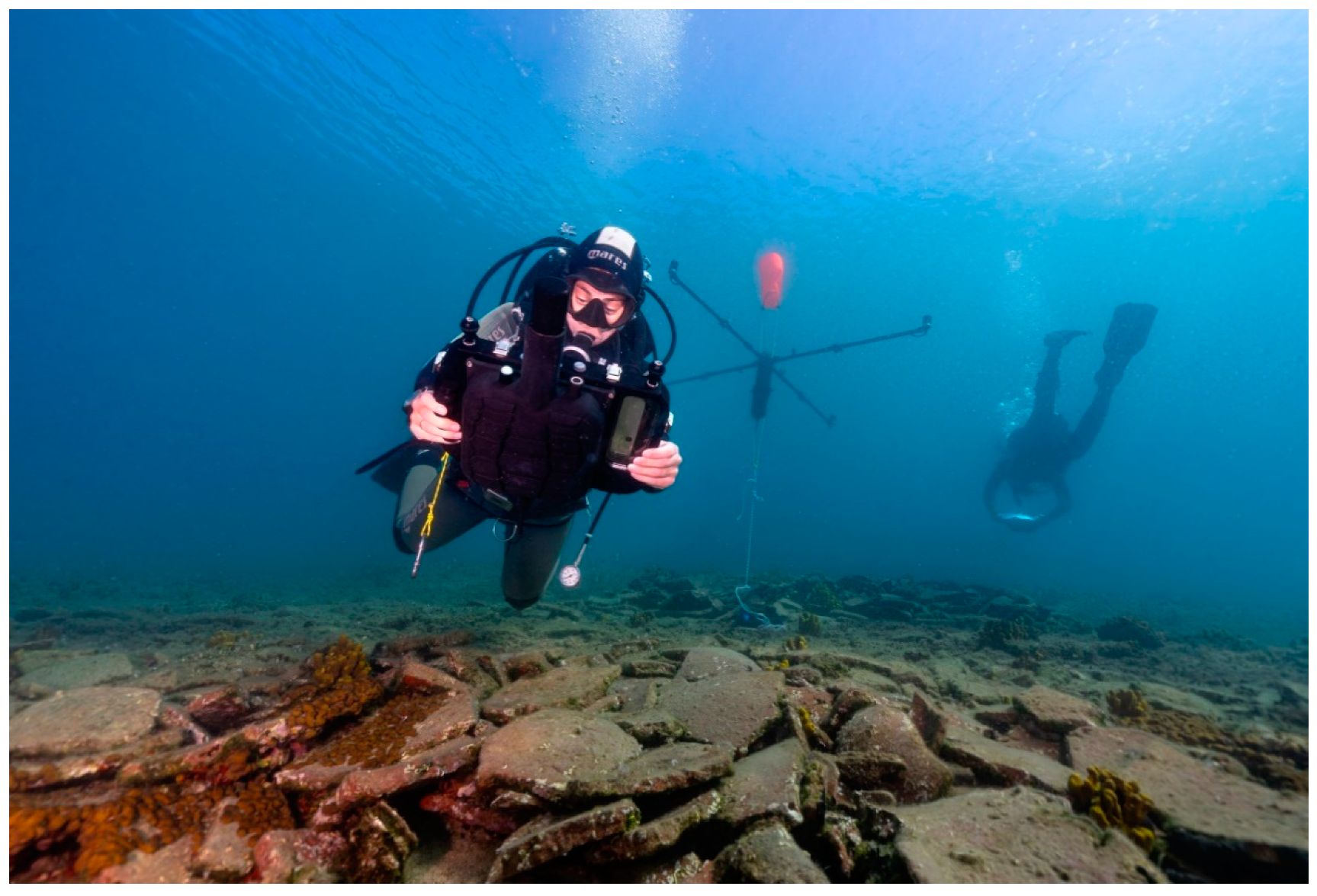
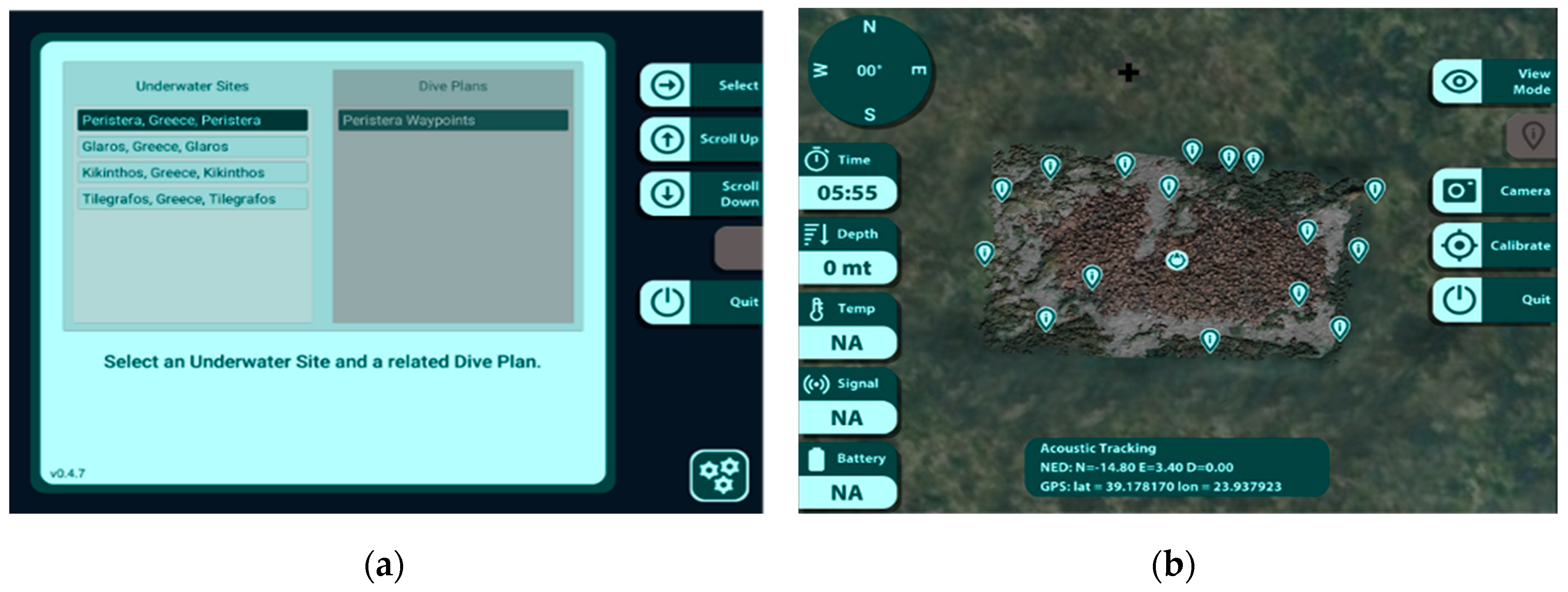
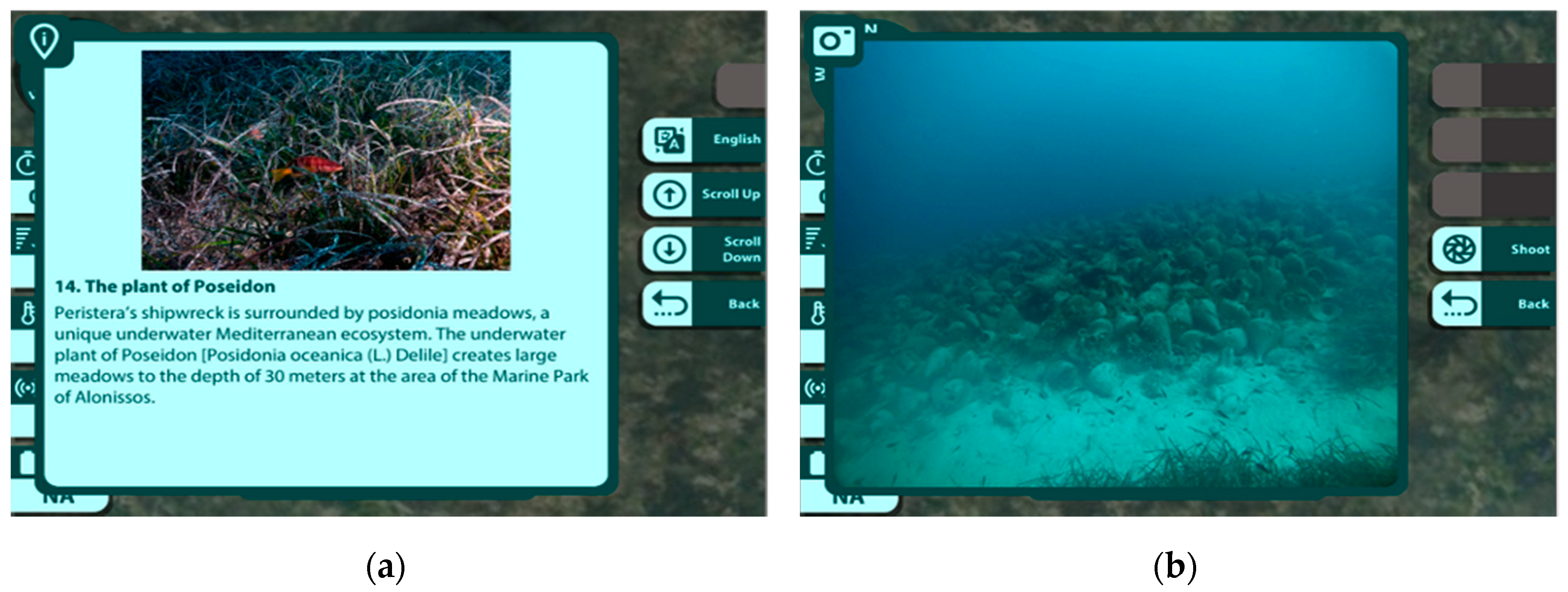
2.1. Virtual Diving on UCH

The Virtual Diving application consists of a VR experience that enables users to simulate a real diving session from the scuba diving viewpoint and explore the 3D digital replica of the seven pilot sites selected for the BLUEMED project, respectively in Greece, Italy and Croatia. The virtual diving application has been designed and developed to engage users to explore all the underwater archaeological sites’ scenarios, which are dynamically loaded in runtime from a single application. The software is implemented by means of the cross-platform game engine Unity [13]. Its architecture is composed of five main elements: a database, a web service, a scene editor module, an interaction module and the controller. The Virtual Diving application can be directly used via web because it communicates, by means of the web service software, with a database dedicated to data uploading and downloading. The scene editor module allows for operating (read, write, modify and delete) the database and for putting together these data to build the virtual scenario of a specific underwater archaeological site (Figure 1).
The key elements in every virtual scenario are the 3D texturized model of the underwater archaeological site, the 3D models of the flora and fauna and the Points Of Interest (POIs) placed within the scene. A specific methodology that involves the work of a multidisciplinary team composed of engineers, biologists, archaeologists and data management experts has been developed to create these elements with the aim to make the virtual environment visually and behaviourally realistic [10]. It includes the survey and 3D reconstruction of the underwater archaeological site using both optical and acoustic 3D imaging technologies and its inspection, where various useful and interesting locations are defined and geolocated. These POIs, which are added to the virtual scene in the form of 3D large head map pins (Figure 1), indicate the location of interesting objects of specific feature types, such as one or a group of archaeological remains, and they are stored in the database in a fact-sheet format that includes their attributes (name, geographic coordinates, category/type) and multimedia content (text, image, audio and video). Moreover, 3D models of fish and schools of fish, typical of that site, are settled into the underwater environment and are animated by means of artificial intelligence techniques. The vegetation is placed exactly as it was captured during the optical survey and it is reproduced by means of texture effects that mimic the movements of the real plants.
Once the scene is created, the interaction module is adopted to implement the logics of the virtual scenario and to define the physics of the elements in the scene. Furthermore, the module loads the graphical assets of the submerged, terrestrial and aerial environments, such as refractions, fog and caustics of the particulate from the database. The interaction module is used also to perform the exploration within the virtual scenario following the user input received from the device controller. The user wears a Head-Mounted Display (HMD) to navigate the virtual environment and uses the device controller to point in the direction where he wants to move on, pulling the trigger to swim. The device is also used to interact with POIs, receiving historical/archaeological information about the submerged artifacts (Figure 2).
The exploration of the site can be performed in two different modes that can be selected by the user on the UI: free or guided tour. In the first mode, the user can dive freely in the archaeological area and he/she is free to pick the desired POI or simply take an overview of the submerged area. In the other case, the guided tour mode features a virtual diver who guides the user during the exploration of the underwater archaeological site. In particular, the virtual diver implements a logical follow-on of the POIs that, according to a storyline approach, allows users to follow one or more itineraries and ‘‘theme routes.’’ The storytelling approach motivates players to follow the scuba guide and discover new POIs to interact with. Coupled with the game elements provided by the immersive virtual environment, this allows for maximizing enjoyment and engagement, capturing the interest of users and inspiring them to keep learning (Figure 3).
The software application has been designed to be executed in unmovable museum installation, as in the case of KACs or installed in low-cost HMD devices and easily transportable, to be used during exhibitions, fairs and events.
The Virtual Diving application is a novelty in the field of VR technologies applied to the promotion of underwater sites. It has been designed to raise users’ archaeological knowledge and cultural awareness by providing them a faithful and realistic virtual replica of real underwater archaeological sites that can be explored by means of an edutainment-oriented approach. In fact, it combines an educational purpose with ludic activities, allowing its users to enjoy the virtual environment by simulating a real diving session from the point of view of a scuba diver, other than learning archaeological and historical information in a playful manner.

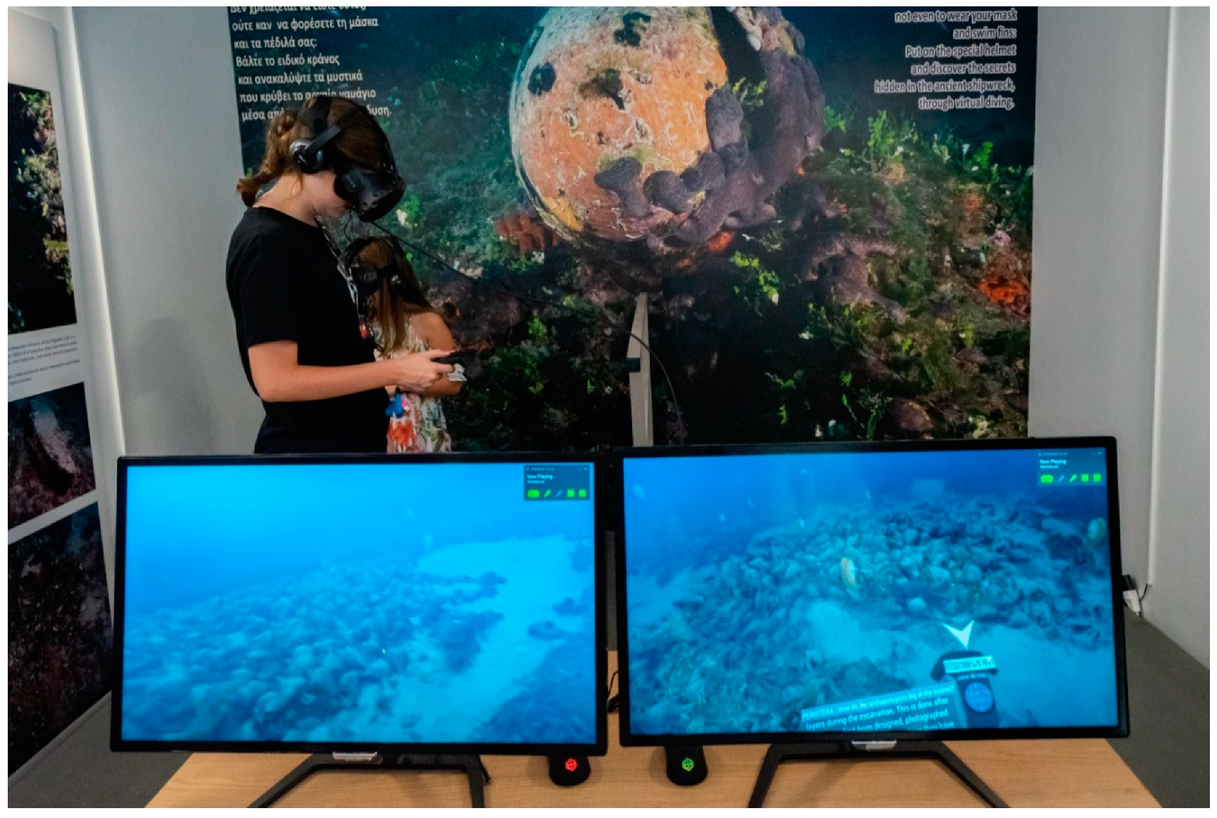
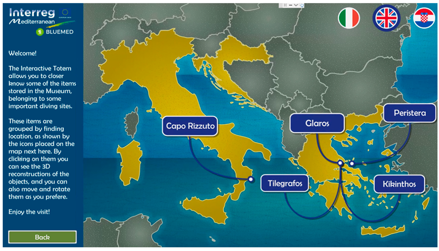
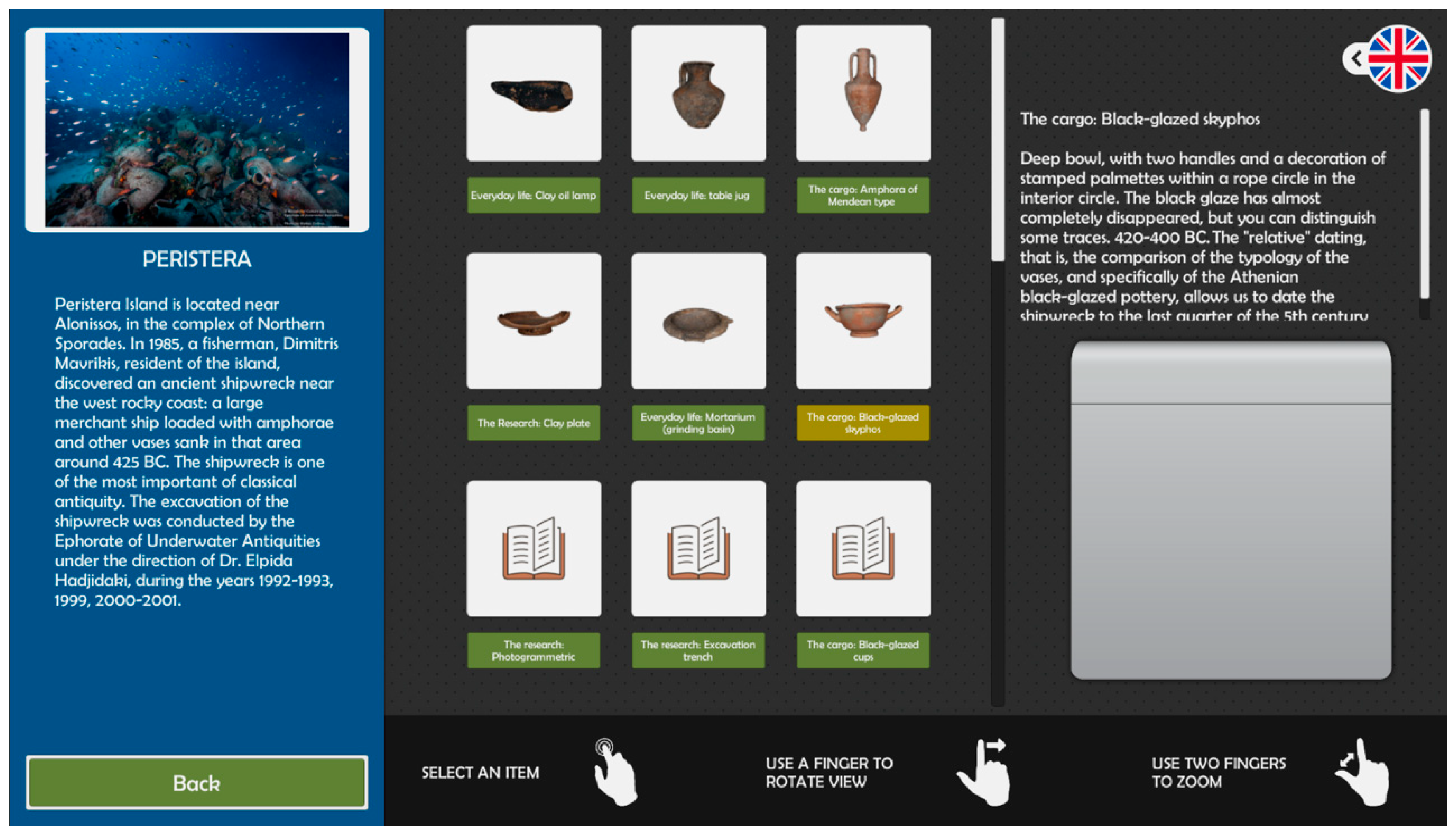
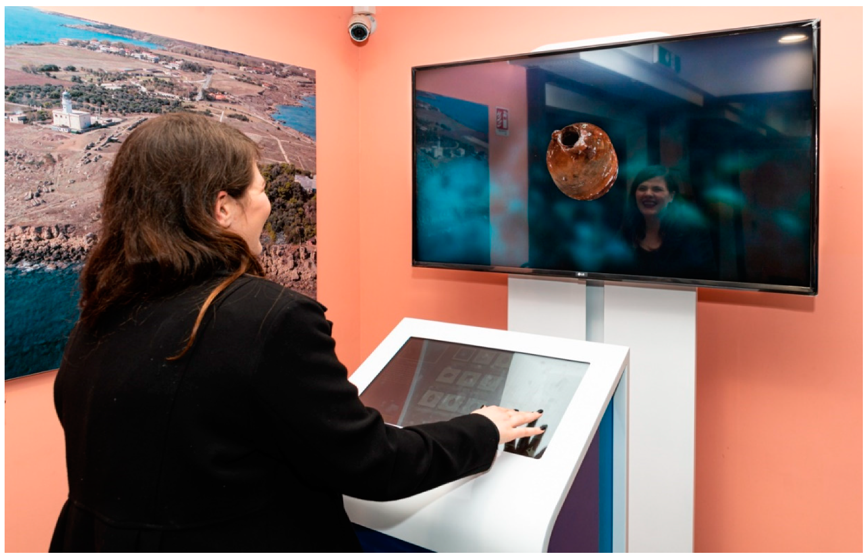
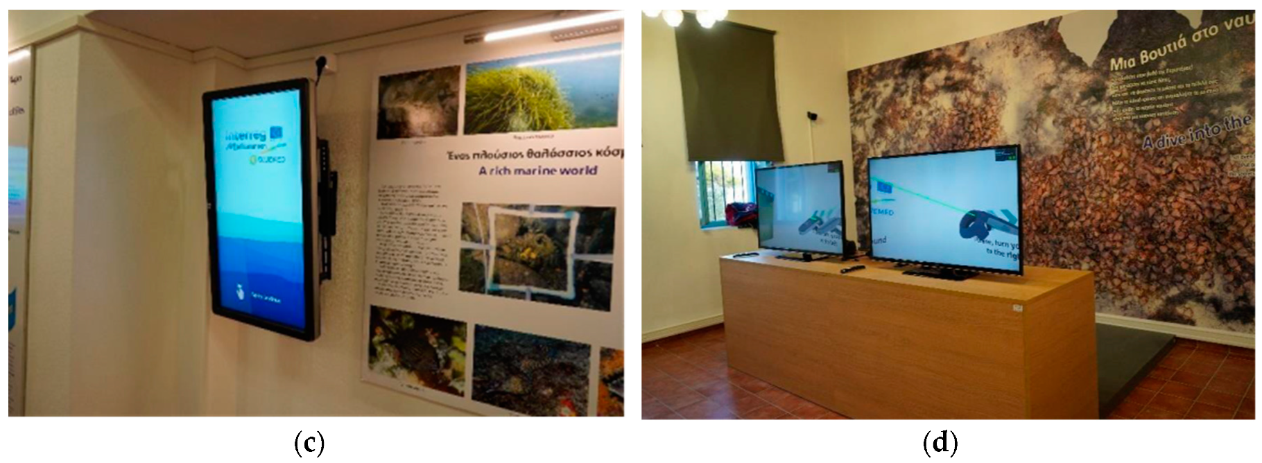
2.2. The Virtual Museum of Underwater Finds

The BLUEMED “Virtual Museum” is an integrated platform for multimedia content delivery and networking of museums and exhibition spaces. Its on-line centralized storage system allows for creating virtual catalogues to collect all the textual, multimedia and three-dimensional information about the objects held in a museum, linking them with the objects held in other places.
The software application runs on a system composed of the following hardware devices:
  • TV screen: allows high-resolution visualization of the digital replica of the artefacts;
  • Touchscreen controller: the controller of the application, allowing the navigation of the content and the possibility to interact with the 3D model of the artefact displayed on the TV screen;
  • PC unit: it is the central data processing unit.
The first screen of the software application shows a map where the user can select the language and one of the available “Virtual Museums” (Figure 4).
After selecting one of the available “Virtual Museums”, the virtual catalogue of the artefacts belonging to the site pops up and info about the collection is displayed (Figure 5).
User can select the 3D model of an artefact belonging to the “Virtual Catalogue” by pressing on the relative icon. After the loading phase, the 3D model of the selected artefact will be visualized on the TV screen. Users can interact with the 3D model by using the touchscreen controller. In particular, they can rotate it in all directions by shifting a finger, or they can zoom it through a “pinch in” or “pinch out” gesture (Figure 6).

3. The Case Studies in Alonissos and Amaliapolis (Greece)

In the framework of the BLUEMED project, two pilot sites were selected in Greece for the implementation of Underwater Museums and the establishment of two Knowledge Awareness Centers in the same area. The KACs would support the operation of the UMs by stimulating the general public’s interest in the underwater cultural and natural heritage and enabling both divers and nondivers that live or visit the area to become aware of the underwater wealth found nearby and in other sites across the Mediterranean. To this purpose, the KACs were created near the UMs while the sites and the KACs were equipped with AR and VR technologies, respectively, to offer an advanced physical and/or virtual diving experience to the visitors.
The first KAC was established on Alonissos island near the AUCHS of “Peristera”, which is found off the nearby Peristera islet. They are both located in the Northern Sporades sea area and are part of the National Marine Park of Alonissos Northern Sporades, the largest protected marine area in Europe (2315 km2), where the monk seal (Monachus monachus) and other rare marine species find refuge. The second Greek KAC was realized in Amaliapolis, a seaside village on the western side of the Pagasetic Gulf, where three other Underwater Museums are found nearby and presented in the following sections.

3.1. The Underwater Museums (UMs)

Along with KACs, BLUEMED project has developed, implemented and promoted in the selected pilot sites a new concept of an Underwater Museum to handle the problem of the conservation/preservation of the UCH as well as enhance blue growth in the area based on the responsible exploitation of the underwater sites for touristic purposes [44,45,46,47,48,49,50,51,52]. The Underwater Museums have been designed to offer the users an experience as complete and educative as the one they can have at a “dry” and on-land museum. To encourage the visits at the sites and attract recreational divers, an Augmented Diving system [8,9,10,11,12,13,14,15,16,17,18,26,27,28,47,48], consisted by an underwater tablet and a localization system has been developed, to localize divers and guide them during the dive (detailed in Section 5). For each pilot site, a specific path has been designed that shows all the Points of Interest (POIs) located in the UM. Every POI includes a digital content or a text that the diver can read or see during the visit. This allows the user to have the same experience of a guided visit in a “dry” museum, giving the possibility to better understand what he is visiting in specific “thematic routes”, oriented on both the cultural and biological aspects.
In the two Greek pilot sites (Alonissos and Western Pagasetic Gulf), four UMs were designed, as described below.

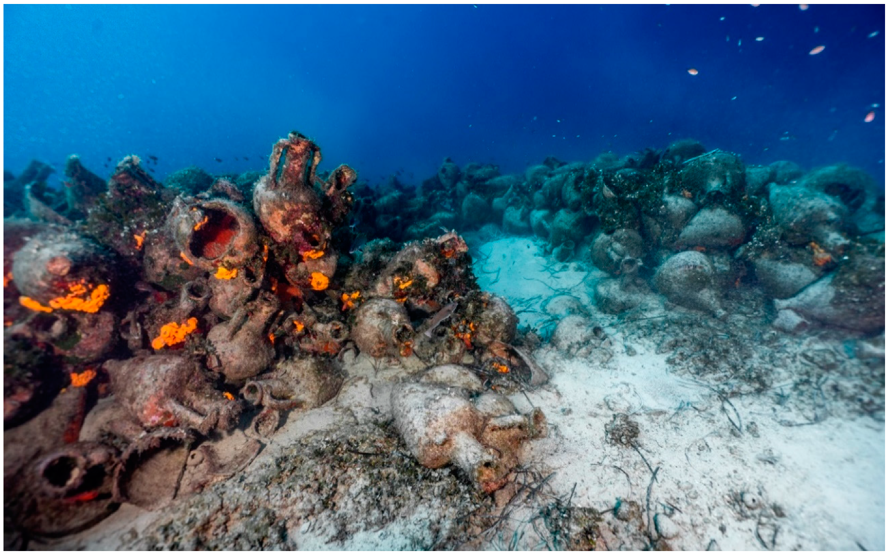
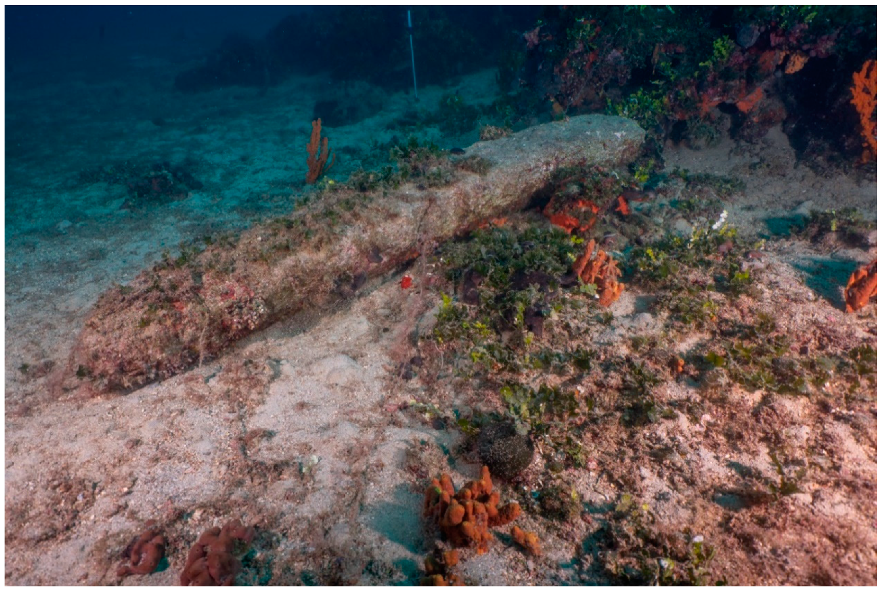
3.1.1. The Accessible Underwater Archaeological Site of “Peristera” Shipwreck (Alonissos)

The “Peristera” shipwreck is located at the north of Kokkalia bay near the west rocky coast of Peristera islet [44,45,46,47,53,54,55,56,57,58,59,60]. This large wooden merchant ship of the classical period is considered to be one of the largest of the classical period and at the same time an evidence of the importance of trade in that period. An extremely massive and impressive pile of transport amphorae still remains on the seabed, which almost still keeps the shape of the wooden hull of the ship. The cargo was mainly composed of wine amphorae from Mendi (ancient city of the peninsula of Chalkidiki) and Peparethos (today’s island of Skopelos), area known for their wine in antiquity. The ship also transported several fine black-glazed vases that were used in the Athenian symposia: cups, plates, skyphoi, as well as small cups.
“Peristera” shipwreck with its dimensions (25 m length and 10 m width) and its huge number of amphorae, almost four thousand, is extremely significant; it provides the first archaeological evidence that cargo vessels with over one hundred tons of cargo travelled the Mediterranean as early as the 5th century BC (Figure 7).

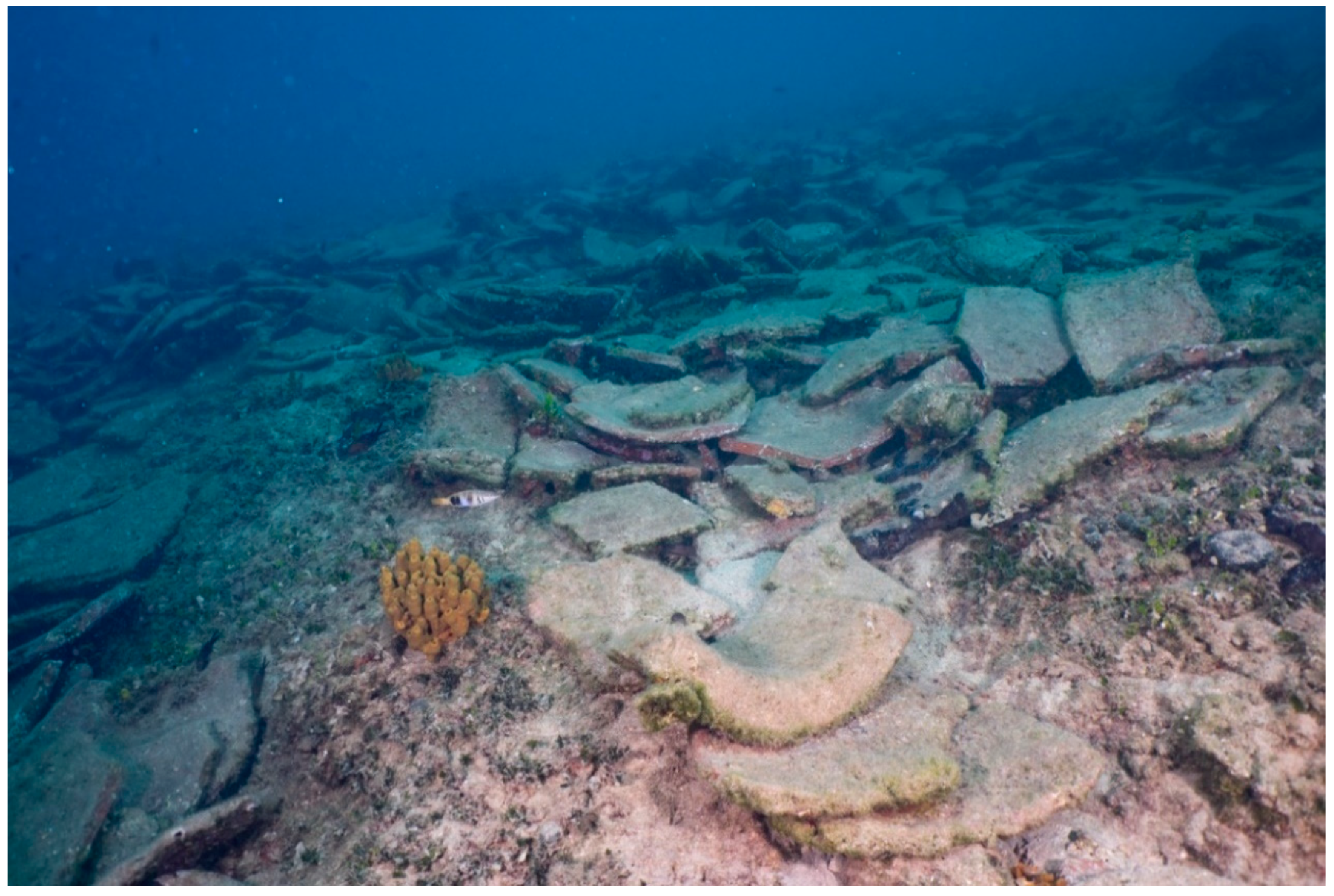
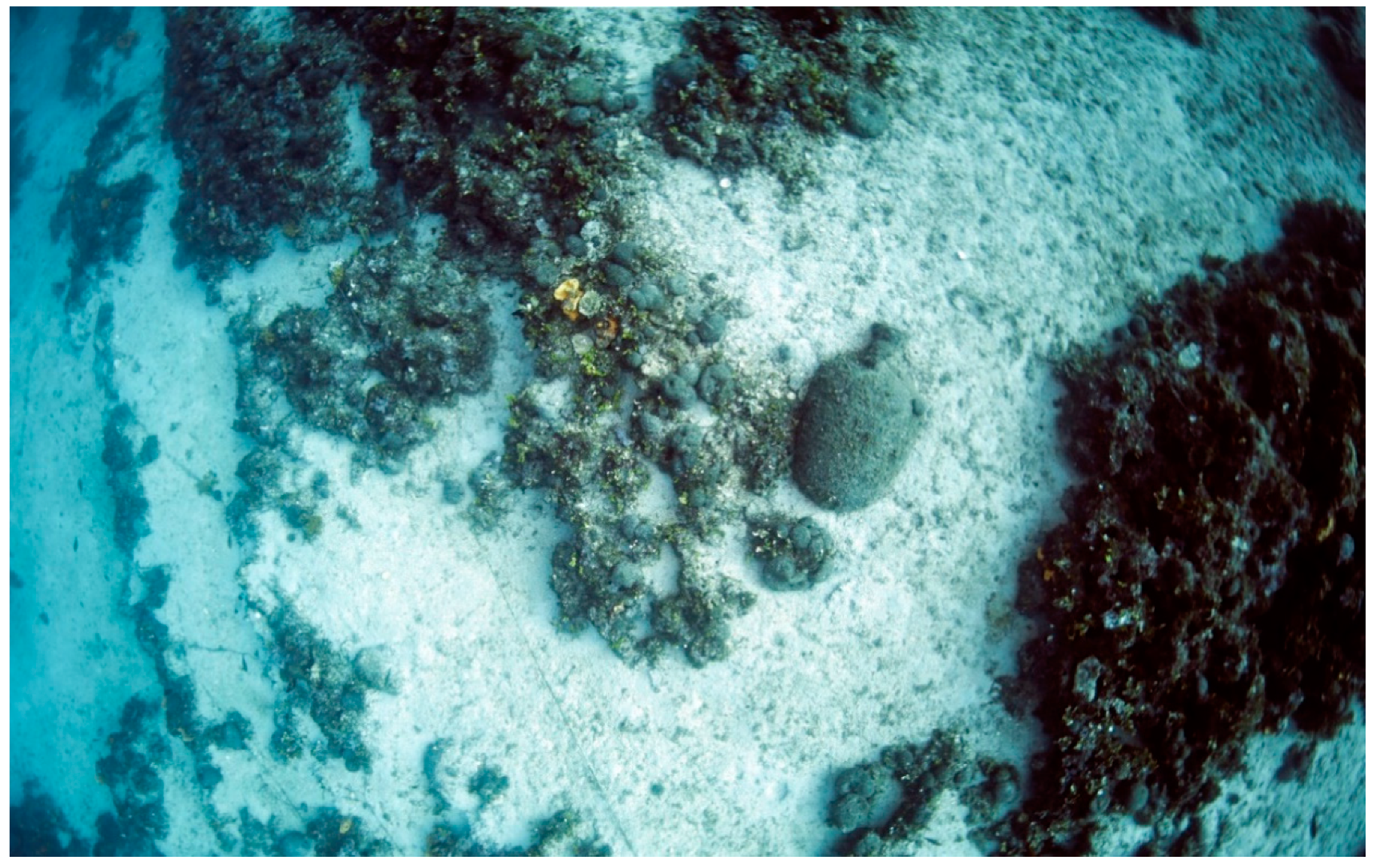
3.1.2. The Underwater Archaeological Site of “Kikinthos” Shipwreck (Western Pagasetic Gulf)

On top of the rocky coast inclining westward, the remains of a Byzantine shipwreck cargo of mainly pithoi (Figure 8) are located from around 3 to 11 m where the sandy bottom starts [53,54,55,56,57,58,59,60]. An area of around 8 × 12 m is covered by big pithos sherds that can be attributed to at least three different types. Among the pithoi there are also sherds of two types of amphorae, dated to 11th–13th c. AD., period during which the ship must have been sunk. The pithoi types remain unchanged for centuries, as such jars can also be dated as early as 8th–9th century AD. The presence of pithoi indicates that the ship’s cargo was carried in bulk, such as cereals, leguminous vegetables, fruits (almonds, walnuts, raisins, olives, etc.). Though the cargo is fragmented it has been preserved in a quite concentrated form, presenting a clear picture of the point where the ship had landed at the sloping rocks of the coast. It is also indicative of the flourishing, during the Middle Byzantine times, trade directed to the centres around Pagasetic Gulf.

3.1.3. The Underwater Archaeological Site of “Akra Glaros Cape” (Western Pagasetic Gulf)

The entire cape of Glaros, at the southwestern entrance of the Pagasitic Gulf, is a dangerous passage for ships which tried to enter the protected bay of the ancient Nies. At Akra Glaros Cape at least four shipwrecks were recognized, a Hellenistic one (3rd–2nd century BC), an Early Roman one (1st–2nd century AD) and two of Byzantine times (12th–13th century AD) whereas pottery of Late Roman times is also present [53,54,55,56,57,58,59,60]. The findings related to the aforementioned shipwrecks are so dispersed and mixed that the definition of the different shipwrecks is really a hard and not yet concluded task. Two neighbouring areas at the western half of the promontory have been chosen to be used as underwater archaeological parks offering the chance of at least two full dives. At the seabed of Glaros, an impressive set of anchors of different eras has been located. First of all, more than ten “Y” or “T” shaped iron anchors of the Byzantine era can be seen. Moreover, a great stone stock of a wooden anchor—its length is almost two meters—of the Archaic period (7th–6th century BC) and an ancient stone anchor with three holes are located (Figure 9). Around them, intact amphorae and big amphorae fragments of different periods can also be seen witnessing different lost cargoes or jettisons. Apart from the ancient remains, the rocky steps are full of plants and sponges of several colours combining the cultural with the natural environment.

3.1.4. The Underwater Archaeological Site of “Telegrafos” Shipwreck (Western Pagasetic Gulf)

At Telegrafos bay, the rest of the cargo of a roman ship lies at a depth from 17 m to 23 m [53,54,55,56,57,58,59,60]. Unfortunately, the site was looted. Despite that, an archaeological excavation brought to light the rest of the cargo and the thorough study led to the recognition of three main types of Late Roman (4th century AD) amphorae which constituted the main cargo and five other types in smaller amounts (Figure 10). The amphorae which were carried by the ship are of great interest, since they narrate a small episode of the transitional phase between late antiquity and the medieval era. The composition of the cargo reflects the changes that occurred in the production centres during that period: most amphorae belong to a type quite unique for the 4th century AD, which will nevertheless inundate the Eastern Mediterranean for the next two centuries. The second most common type was unknown until the discovery of the shipwreck: perhaps it comes from a small wine-production centre that either stopped the production or was adapted to a common type. A third type of amphora may represent small island production centres in the Eastern Mediterranean. The other five types, with few samples from each one of them, may belong to an older cargo of the ship that was not sold or perhaps they were used by the crew. The cargo indicates a ship travelling along the sea routes of the Late Roman—newly established Byzantine Empire—across and along the sides of the Aegean Sea. As far as the shapes are concerned, the roman shipwreck of the 4th century AD provides us with type characteristic of the evolution from the ancient “pointed-base” amphorae to the later byzantine ones with the hemispherical base: the size of the body is reduced, the shape becomes intensely oval and the small pointed apex tends to become hemispherical. In the interior of the sides, residues of tarsus were found, a possible indication that the vases contained wine.

3.2. The Structure and Management Model in the Greek KACs

The structure and management model followed for KACs implementation, ensured compliance with legislation, principles, parameters and good practices. The primary goal of BLUEMED project focused on the sustainable development of a specific sector in the field of cultural heritage, i.e., the Underwater Cultural Heritage (UCH).
A different protection regime prevails in every country and the rules and procedures followed regarding UCH sites and connected activities are based on the national legislative regulations. So, although legislation, management systems, staffing and facilities could differ from one country to another, all the KACs realized in the MED areas within the BLUEMED project have pursued common goals and served similar purposes: the provision of knowledge and the promotion of the underwater cultural and natural sites through on-land innovative exhibitions; and the organization of diving excursions in underwater pilot sites, creating tours in ad-hoc guided trails. Therefore, considering the different legislative frameworks that have been developed from country to country, the BLUEMED operational and management model is more like a general framework that any country may adopt and adjust accordingly to the local context.
Particularly, the model and good practices used for the two Greek KACs follow the guidelines defined in the framework of the BLUEMED project, which have been carefully developed and readapted based on the existing national regulations. Particularly, a simplified Management Model suitable for KACs implementation was developed and adapted to the specific field of Underwater Cultural Heritage, reflecting some of the UNESCO 2001 Convention practices [4,5] and other models for Cultural Heritage Management. Such further models include the Integrated Coastal Zone Management (ICZM) [49] and Maritime Spatial Planning (MSP) protocols [49,50,51,52], both focusing on establishing a common framework for the maritime spatial planning and integrated coastal management in the EU Member States to promote the sustainable growth of maritime and coastal activities and the sustainable use of coastal and marine resources.
Starting from these protocols, a spatial planning of the coastal area was undertaken to ensure the sustainability and environmental health of the sites selected to host the KACs, respecting the environmental limits of ecosystems. This approach represented a fundamental baseline upon which the BLUEMED project was developed, with the realization of the KACs as one of the main milestones. To be more specific, before implementing the KACs and all the related activities, the project partners and local authorities (i.e., stakeholders, managers, etc.) carried out a screening procedure to determine whether the plans or the scheduled programs would have led to significant environmental effects. Secondly, the tourist-economic value that the KACs would have collected on the territory was taken into consideration. The establishment of Knowledge Awareness Centres (KACs) and their combination with accessible underwater sites represented another point of reference in terms of the broad and attractive promotion of the underwater cultural heritage. KACs are nowadays attracting tourists (not only divers) from around the world and enhancing the tourism development with revenues for the sites and other tourism businesses across the regions.
On the fact, for the initial definition and subsequent planning of the KAC’s management model, every facet has been examined, considering the political, economic, social and cultural perspectives. So, the best strategy was to get started with a strong planning effort, where it was necessary to develop a strategic/preliminary design with a clear vision of the main goals. Later a more specific scope of the project was realized in a sectorial context, such as that of UCH.
To undertake a master plan for the management, it was crucial to involve and engage stakeholders, such as museum professionals, archaeologists, local people, touristic Info-Points, MPAs and other related people or institutions working in the cultural heritage field. This collaborative effort allowed collecting feedback, identifying any issues, priorities, suggestions and application processes.
The management model which was finally developed and applied to KACs is based on a land planning and by the establishment of useful sustainability KPIs checklists, developed to the measurement of the impact on the natural, cultural and economic environment, resulting from the establishment and operation of the KACs. In this sense, the KACs are now using KPIs to compare their performance in terms of meeting their strategic and operational goals on the territory as planned during the project.
The two Greek KACs are nowadays managed by the municipalities, as they are exclusively responsible for their operation. In the KACs, the history of the Underwater Museums (UMs) is highlighted through the collections, exhibitions and virtual tours. In addition, the KACs role as innovative facilities able to offer alternative exhibition solutions to show artefacts coming from marine environments to the general public, is showcased. Moreover, a sustainable management plan for the protection, documentation and exhibition of underwater artefacts is adopted to connect the UCHs to their original context and also provide an on-site interpretation and educational experience for visitors.
The KACs are formed in a way that reflects the cultural sequence and contexts of the underwater archaeological site and artefacts, substantiated by panels with supporting images, photographs and texts, dioramas and various multimedia presentations and equipment. Videos and brochures are also used in the KACs, which act as effective mediators between users and cultural heritage and enhance the visitor’s understanding of the archaeological site and the enjoyment of the experience.
Concerning the staffing, KACs include personnel specially trained by BLUEMED partners, with clearly defined duties and having all the necessary skills useful to manage the activities. The staff is trained in such a way that can answer the queries of the incoming visitors as well as to facilitate the access even to the “real” underwater archaeological sites and trails.
The two KACs are very proficient facilities able to enhance the traditional exhibitions by combining the typical information and communication activities of Visitor Centres and Info-Points with innovative technological solutions. These include the Virtual Reality System as a central feature of the exhibition and other multimedia devices to enrich the educational benefits and the entertaining character of the visit at the KACs. More particularly, through TV screens and a touch screen system various digital information material about the sites is available; there is a video projected on the BLUEMED pilot sites, while information on the cultural and environmental features of the sites is also presented in detail through the available touch screen. The content of the exhibitions hosted in the two KACs is under the supervision of the Hellenic Ministry of Culture and Sports. In a five-year timeframe, the assessment of the exhibition content and planning is required to update the information and the design, check the technology systems and equipment and resolve issues of maintenance and security of facilities. What is more, for the sustainable operation of the KAC, future funds should be purchased by the competent management authorities and the right marketing and promotional strategies for the attraction of visitors need to be further evaluated and updated. Most importantly, the realization of more KACs in other MED locations is going to maximize their multifaceted roles and great potentials.

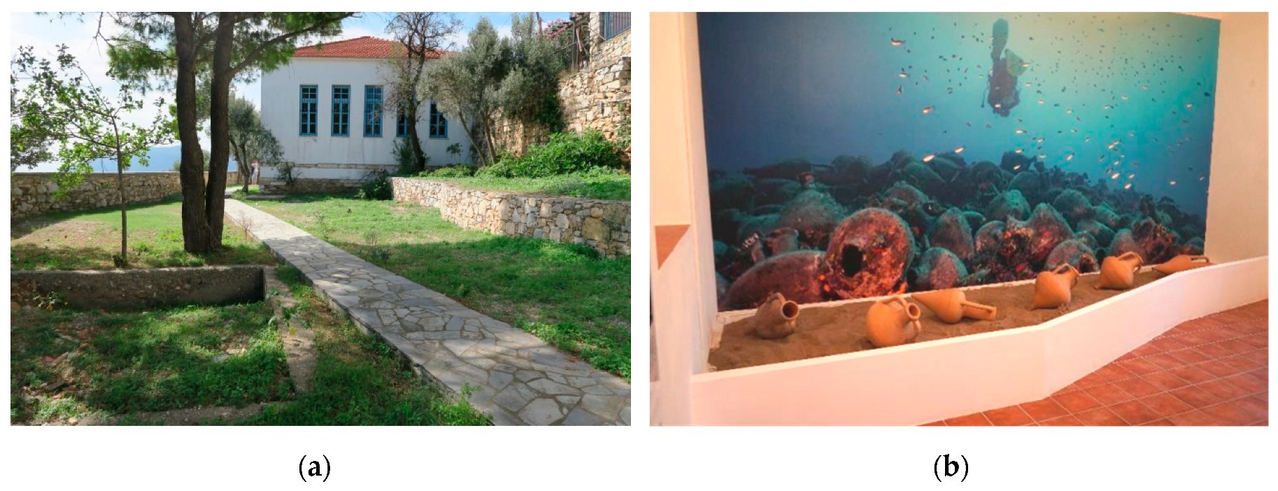
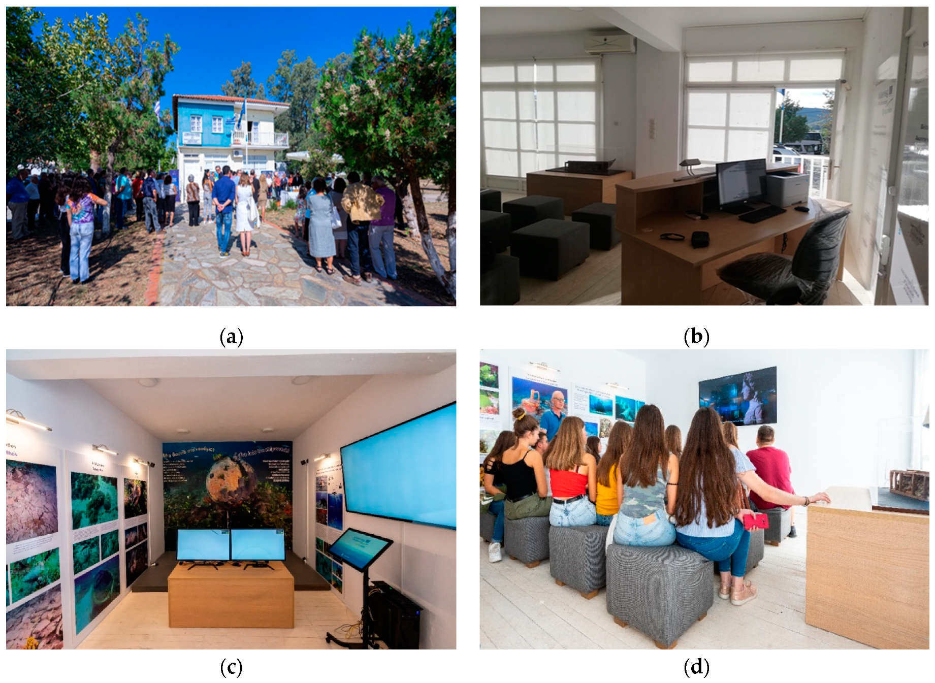
3.2.1. The Alonissos KAC, Location, Site Planning and Building Features

The KAC in Alonissos was realized in a public building, and specifically in the old elementary school of the island, in Chora, currently granted to host the exhibition. The KAC can be easily reached since distinct signage has been placed by the Municipality of Alonissos in collaboration with the Region of Thessaly, which guides visitors to the structure. Additionally, there is a connection to public transport and a large parking area, which facilitate the accessibility of the KAC and other adjoining tourist businesses, such as shops and restaurants, which assist the operation of the KACs, as they could work complementary to satisfy the variable needs of the visitors.
The KAC covers an area of about 115 m2 and it is divided into four main halls: (a) the reception, with archaeological and environmental information on the BLUEMED pilot sites; (b) the conference room, being the video projection room and the area to host public awareness events; (c) the hallway and (d) the exhibition room, where the Virtual Diving System and other multimedia devices were installed. More particularly, these include a marine biology touch screen system and a touch console that holds a selection of several videos to choose among and a virtual museum system. The latter one includes an interactive virtual station with the visualization of all the 3D finds of the BLUEMED pilot sites. There are also dioramas and artefacts related to the pilot site on display in this section. Panels are placed all over the KAC giving information about the other pilot sites.
The entire documentation material for the operation of KAC in Alonissos was provided by the Ephorate of Underwater Antiquities (EUA). More specifically, EUA, as a department within the Greek Ministry of Culture and also a partner of BLUEMED, arranged the necessary information for the digital applications, produced and edited the texts for the signs and the panels and delivered the Greek audio archives for the needs of the digital applications and the bilingual video (in English and Greek language) “BLUEMED Sustainable Tourism” displayed at the KAC.
In addition, information on the marine biodiversity is also provided to visitors. Particularly, a “marine biology” application presenting 10 key species (macrophytes, algae, invertebrates, and fish) from each dive site has been developed. This application is available on touch screens where the visitor can learn about the marine biodiversity of the all the pilot areas of the project (i.e., the wrecks in Peristera, Cape Glaros, Kikinthos and Tilegrafos for Greece; Baiae and Capo Rizzuto for Italy and Cavtat for Croatia). The information is available in English, Greek, Italian and Croatian. Posters with the data and results from the fieldwork activities carried out to record marine biodiversity and abundance at each area are also available (Figure 11).
Among the activities of the KAC, guided visits are also planned for divers along specific underwater trails at the accessible underwater archaeological site of Peristera, one of the BLUEMED pilot sites.

3.2.2. The Amaliapolis KAC, Location, Site Planning and Building Features

The KAC in Amaliapolis (Almyros, Greece) is the second Knowledge Awareness Centre established in the framework of BLUEMED, which along with raising awareness on underwater cultural heritage also aims at enhancing tourism development in the area.
The KAC covers the ground floor of a public building, owned by the Municipality, which accommodates the Coastal Amaliapolis Fund. In the building, there is an exhibition area, with a usable area of 80 m2, divided into three main rooms: the reception, the conference room and the exhibition room. When the visitor enters the reception area, they can get general information about the exhibition. Moving on, a diorama picturing a section of an ancient Greek shipwreck with a cargo of amphorae is displayed along with several printed panels with archaeological and environmental information. Finally, there is the video projection area and the exhibition room, where the Virtual Diving System and other multimedia devices have been installed.
The equipment of the VR applications, the information material and all management tools installed are very similar to that realized for the Alonissos’ KAC. The archaeological information on the Greek pilot sites was provided by the EUA, while the exhibition was enriched with biological data on the variability of the marine ecosystem collected in situ by the project partners (Figure 12).
Both the KACs in Alonissos and Amaliapolis allow visitors to discover the world of underwater archaeology and find out about the Accessible Underwater Archaeological Sites (AUAS) and under what conditions someone can dive there. What is more, the use of digital technologies such as the VR system gives to nondivers the possibility to have a virtual dive in the impressive ancient shipwreck of Peristera. What is more, the KAC digital exhibition based on the virtual reality applications and the other multimedia devices offers an appealing educational experience to visitors. The users not only are informed on the underwater archaeological findings and the marine environment but also they are able to enjoy a virtual diving experience, suitable for all ages and their needs.

4. Evaluation and Users’ Feedback

Users Experience and Visitor Satisfaction Survey in Alonissos and Amaliapolis

For the sustainable management and operation of the KACs, the evaluation of the satisfaction of visitors and the VR users’ experience are important parameters. To this purpose, a validation questionnaire was created in the framework of BLUEMED, based on an assessment methodology and predefined KPIs that focused on the provided services, the sociocultural impact of the KACs and several aspects of the visitors’ experience. During 2019, both KACs in Alonissos and Amaliapolis were fully operational for only a short period after their opening in September; therefore, in order to overcome limitations in the representative data collection, two school visits of local junior and senior high school classes were organized at the KACs in November 2019. This survey gathered 104 questionnaires, 77 and 27 from Amaliapolis and Alonissos, respectively. During the following operating period and more specifically between July and August 2020, 82 more questionnaires were collected from the visitors at the KAC in Alonissos. In total, the survey sample reached 186 questionnaires and the analysis of the results produced some useful remarks on the operation of the KACs; it thus outlined the impressions of both locals and visitors.
The questionnaire included 26 questions in total, both quantitative and qualitative, with key questions exploring the KACs’ attractiveness to different age groups as well as to both divers and nondivers, thus addressing demographics and accessibility issues. Since the main technical aspects of the virtual diving experience have been already analysed and presented in [16], the current survey has been mainly focused on documenting the level of satisfaction of visitors with the services offered at the KACs, such as the physical and digital exhibition content. It also aimed to evaluate the overall impact of the technological solutions installed at the KACs (VR service, multimedia touch screen and video) in terms of friendly use and raising awareness on the value of underwater cultural and natural heritage.
The main indicator of the good performance of the KAC is that the majority of research participants (97%) stated that they were very satisfied with their experience at the KACs and in the comments they have also emphasized the appreciation for the VR experience and the informative content of the exhibition.
For most visitors, the KAC was the first time they became familiar with the underwater cultural heritage; it motivated them to find out more about the sites. To this purpose, the contextual environment of the VR application provided information on both the archaeological remains and the marine ecosystem. To support the above, most respondents described also the video and the touch screen content predominantly as “educational”, which indicates the public’s interest in the marine cultural and natural environment and confirms how the different technical solutions installed at the KACs responded to the visitors’ interests.
If combined with the fact that most survey participants were not divers, it also underlines the role of the KAC in raising awareness on underwater cultural and natural heritage. The visit at the KACs was a strong trigger for the respondents to consider becoming divers or visit other AUCHS in the area (90%). Equally high was the percentage of those who would recommend a visit at the KAC to a friend.
According to the results of the survey, the virtual diving experience emerged as the highlight of the KAC exhibition. In fact, the VR experience generated interest in both the archaeological information about the sites as well as the technical features of the VR application and the 3D reconstruction of the underwater remains. More specifically, the interest of the public, and especially the teenagers, has been focused on the process for creating the 3D models of the underwater site as well as the computer graphics effect used to realistically recreate the virtual environment. As a result, the original excitement for trying the VR application generated interest also in the cultural contents provided through the VR, such as the location of the shipwrecks and their preservation condition or accessibility.
The main concern expressed by the participants to the survey was about the limited time available for everyone to experience the virtual diving system. This problem was mainly due to the large number of visitors at the KAC at the same time and even if two VR system were available, most of the visitors were not able to enjoy the VR as long as they wanted to. Visitors considered that a time frame of 30–60 min was enough to explore the KAC exhibition and try the VR service, while in case of group visits it was found that these should not exceed 15–20 people per time. Despite the VR system considered by the majority as user friendly, the respondents’ answers indicated that designated personnel is needed to guide the users and manage any difficulties in managing the VR headset. This can be considered as a relevant issue for the management of the KAC, because the personnel have to take care to assist the visitors in wearing and starting to use the VR headset.
The results of the survey showcased how the VR application can upgrade a visit to an exhibition to a fun experience and contribute to stimulating the general public’s interest in the underwater cultural and natural heritage. Moreover, they were very encouraging regarding the prospects of the sustainable operation of the KAC and showed that KACs can be popular tourist attractions in an area. It is indicative that the KAC in Alonissos hosted over 1300 visitors in August 2020 including people from abroad. Among the issues to consider, what arose was the dissemination of the KACs and the need for an online version of the available questionnaire, in order for the evaluation to continue in the future with greater participation.

5. Diving with AR

The Augmented Diving System for the Underwater Museums of Alonissos and Amaliapolis

The Augmented Diving system is a technological solution designed to improve the visitor experience in underwater museums or marine parks. It is intended for scuba divers who are going to visit the underwater site, allowing them to have a virtual guide that provides specific information about the artefacts or the biological and geological features spotted during the visit. Divers know their geographic position within the underwater site and can follow a planned route set by the underwater museum’s guide.
The system allows shooting georeferenced photos that can be uploaded on a dedicated social website at the end of the diving session, where divers will be able to share the most exciting moments of the dive. It should be also used for both documentation and monitoring purposes. In fact, professionals who are involved in the preservation of archaeological/naturalistic underwater sites can relevantly increase the efficiency of their work making it possible to acquire much more data in the same diving session if compared to traditional methods.
The system architecture designed for the BLUEMED project is based on a fixed underwater platform and up to five underwater tablets equipped with an acoustic positioning and orientation system. A database is also used for the uploading and downloading of the data related to the underwater archaeological site (3D map, multimedia contents linked to the Points of Interest, etc.) (Figure 13).
The acoustic underwater localization system is a commercial solution provided by the Italian company Applicon s.r.l. while the underwater tablet is composed of a Samsung Tab S3 embedded in the DivePad underwater case provided by the Italian company EasyDive.
A custom application has been developed for the underwater tablets. When connected to a remote server, it is able to download the latest version of the 3D map of the selected underwater museum and the related “thematic routes”. Once the map is downloaded, the internet connection is not needed anymore and all the data necessary to dive are stored offline. When the map is completely loaded, the main screen appears (Figure 14).
The most important info about the dive and the system, like the depth, the temperature, the quality of the signal and the status of the battery are shown on the left side of the screen. The map is displayed in the central part of the app, with the 3D model of the site, indicating the diver position and suggesting where the POIs are located. The map is the result of the 3D optical and acoustic survey activities done during the BLUEMED project. In fact, on the archaeological site, a high detailed model obtained by the photogrammetry process is available meanwhile the surrounding area is described by the bathymetry acquired with an acoustic multibeam system.
On the right side of the interface, a menu is shown with all the features available in the app. Those five buttons correspond to the physical buttons present on the tablet case, making the selection very fast and precise. All the underwater operations inside the app are performed through these buttons, and thanks to these, typically, the user becomes very comfortable after a few minutes of use.
In order to activate a POI, the diver needs to go close to the icon on the map. When divers are close enough, the button becomes clickable and a screen with the related information is shown. Moreover, it is also possible to switch the language during the dive, allowing more users from different countries to use the same tablet. Another feature available to the diver is the possibility to shoot a photo, enabling the users to take a georeferenced image and download it after the dive directly on social media (Figure 15).
The Augmented Diving System has been successfully tested during the BLUEMED project activities carried out in the underwater pilot areas located in Italy, Greece and Croatia. It is currently available to be used in the selected Underwater Museums where divers can hire it from the authorized diving centres and use it during the guided tours of the sites.

6. Conclusions

The paper has presented a novel model for promoting the virtual and physical accessibility of UCH, thus stimulating the sustainable tourism in minor coastal destinations of the Mediterranean basin. It has been described how VR and AR systems can improve the accessibility of the submerged archaeological sites by both diver and nondiver tourists.
In particular, the Virtual Diving application provides to the large public the possibility to enjoy a dry dive in eight different underwater archaeological sites located in Greece, Italy and Croatia, thus creating a virtual network of Mediterranean UCH.
Such kind of system can be complemented with traditional and other multimedia exhibits to create KACs that can represent the access point for the tourist interested in visiting or simply knowing the valuable cultural assets that lie on the Mediterranean seabed. In particular, users visiting a KAC, namely Knowledge Awareness Centre where advanced digital technologies merge with traditional museum management practices, will be able to enjoy a single experience of numerous sites among those existing in the Mediterranean basin and properly selected within the BLUEMED project. They will learn how the remains of the shipwrecks that are digitally presented to the public represent the witness of ancient civilizations connected by intensive trades. At the same time, KACs try to raise the public awareness about the need to preserve this heritage for the next generations by describing, throughs the informative panels, how archaeologists, restorers and biologists cooperate to ensure a proper conservation of the archaeological remains.
Besides, the tablet-based AR system represents the tool that can improve the experience of the divers by showing them their position over the 3D map of the underwater archaeological site and providing information about the most relevant point of interests spotted during the visit.
Generally, AR and VR technologies are increasingly being used in the underwater cultural heritage field, where real and digital objects/finds are used to create content-rich virtual environments that can be used to enhance the users’ experience in museum contexts or directly underwater. Although the museums adopting such innovative technologies are still moderate, the VR and AR systems are not just fancy technologies only present in the most renowned museums, but nowadays they represent a reality even in small-scale contexts, in Europe and worldwide. Virtual Diving and Digital Exhibitions should represent opportunities to offer new experiences and be appealing to a new and wider audience.
Particularly, the displaying of objects in VR in the KACs must not lessen or replace real life experiences with object from underwater cultural heritage but rather enhanced the audience’s experiences. On the fact, VR can add a context to the underwater finds and fosters the user’s curiosity, that is to say, to make the observers want to broaden their own knowledge, and then induced them to seek information in real life contexts.
On the contrary, concerning the tablet-based AR system, the goal was adding life to unmovable cultural objects under the sea surface with captions, visual contents and additional information, thus overcoming the constraints of the underwater space.
Finally, the evaluation survey at the KACs in Alonissos and Amaliapolis underlined the great interest of the public and especially nondivers for the underwater cultural and natural heritage and highlighted the VR application as the main attraction at the KACs, with high approval ratings from users. So, in this regard and considering such first satisfaction survey, KACs can rely on technology, and especially on VR applications, as a guarantee of enhanced visitors’ experience.
Additional surveys will certainly be made in the future to monitor the level of user satisfaction over time and to determine whether the KACs’ criteria, designed within BLUEMED, correspond to visitor expectations and move to keep up with the times.

Author Contributions

Conceptualization, F.B.; writing—original draft preparation, F.B., M.R., A.L., A.F.; writing—review and editing, M.R., A.L., A.F., D.P., P.K.; supervision, F.B., A.M., P.K.; project administration, A.V.; funding acquisition, F.B., A.M., A.V. All authors have read and agreed to the published version of the manuscript.

Funding

This research received no external funding.

Acknowledgments

BLUEMED project (Plan/test/coordinate Underwater Museums, Diving Parks and Knowledge Awareness Centres in order to support sustainable and responsible tourism development and promote Blue growth in coastal areas and islands of the Mediterranean) was funded by INTERREG V–B Mediterranean (Med) Cooperation Programme, 2014–2020 and cofinanced by the European Regional Development Fund (ERDF).

Conflicts of Interest

The authors declare no conflict of interest.

References

  1. Gregory, D.J.; Manders, M. Best practices for locating, surveying, assessing, monitoring and preserving underwater archaeological sites. In SASMAP Guideline Manual 2; SASMAP Project: Amersfoort, The Netherlands, 2015. [Google Scholar]
  2. Gregory, D.; Matthiesen, H. Conservation and management of archaeological site. Preserving Archaeological Remains in Situ. In Proceedings of the 4th International Conference, National Meuseum of Copenhagen, Copenhagen, Denmark, 8–10 April 2012; Volume 14, p. 489. [Google Scholar]
  3. Ricca, M.; Alexandrakis, G.; Bonazza, A.; Bruno, F.; Davidde Petriaggi, B.; Elkin, D.; Lagudi, A.; Nicolas, S.; Novák, M.; Papatheodorou, G.; et al. A Sustainable Approach for the Management and Valorization of Underwater Cultural Heritage: New Perspectives from the TECTONIC Project. Sustainability 2020, 12, 5000. [Google Scholar] [CrossRef]
  4. Gifford, J.A.; Redknap, M.; Flemming, N.C. The UNESCO International Survey of Underwater Cultural Heritage. World Archaeol. 1985, 16, 373–376. [Google Scholar] [CrossRef]
  5. UNESCO. Convention on the Protection of the Underwater Cultural Heritage; UNESCO: Paris, France, 2001. [Google Scholar]
  6. Navarrete, T. Digital heritage tourism: Innovations in museums. World Leis. J. 2019, 61, 200–214. [Google Scholar] [CrossRef]
  7. Vaz, R.I.F.; Fernandes, P.O.; Veiga, A.C.R. Interactive Technologies in Museums: How Digital Installations and Media Are Enhancing the Visitors’ Experience. In Technological Developments for Cultural Heritage and Tourism Applications; Igi Glòobal: Hershey, PA, USA, 2018; pp. 30–53. [Google Scholar]
  8. Bekele, M.K.; Pierdicca, R.; Frontoni, E.; Malinverni, E.; Gain, J. A Survey of Augmented, Virtual, and Mixed Reality for Cultural Heritage. J. Comput. Cult. Herit. 2018, 11, 7. [Google Scholar] [CrossRef]
  9. Kang, Y.; Yang, K. Employing Digital Reality Technologies in Art Exhibitions and Museums: A Global Survey of Best Practices and Implications. In Virtual and Augmented Reality in Education, Art, and Museums; Guazzaroni, G., Pillai, A., Eds.; IGI Global: Hershey, PA, USA, 2020; pp. 139–161. [Google Scholar]
  10. Bruno, F.; Bruno, S.; De Sensi, G.; Luchi, M.L.; Mancuso, S.; Muzzupappa, M. From 3D reconstruction to virtual reality: A complete methodology for digital archaeological exhibition. J. Cult. Herit. 2010, 11, 42–49. [Google Scholar] [CrossRef]
  11. Fernández-Palacios, B.J.; Morabito, D.; Remondino, F. Access to complex reality-based 3D models using virtual reality solutions. J. Cult. Herit. 2017, 23, 40–48. [Google Scholar] [CrossRef]
  12. Vermeeren, A.P.; Calvi, L.; Sabiescu, A.; Trocchianesi, R.; Stuedahl, D.; Giaccardi, E.; Radice, S. Future museum experience design: Crowds, ecosystems and novel technologies. In Museum Experience Design; Springer: Cham, Switzerland, 2018; pp. 1–16. [Google Scholar]
  13. Shehade, M.; Stylianou-Lambert, T. Virtual Reality in Museums: Exploring the Experiences of Museum Professionals. Appl. Sci. 2020, 10, 4031. [Google Scholar] [CrossRef]
  14. Bruno, F.; Barbieri, L.; Lagudi, A.; Mangeruga, M.; Pupo, F.; Casavola, A. Cooperative Monitoring System for Diver Global Localization and Operation Support. In International Conference on Design, Simulation, Manufacturing: The Innovation Exchange; Springer: Cham, Switzerland, 2020; pp. 410–421. [Google Scholar]
  15. Bruno, F.; Barbieri, L.; Mangeruga, M.; Cozza, M.; Lagudi, A.; Čejka, J.; Liarokapis, F.; Skarlatos, D. Underwater augmented reality for improving the diving experience in submerged archaeological sites. Ocean Eng. 2019, 190, 106487. [Google Scholar] [CrossRef]
  16. Bruno, F.; Barbieri, L.; Lagudi, A.; Cozza, M.; Cozza, A.; Peluso, R.; Muzzupappa, M. Virtual dives into the underwater archaeological treasures of South Italy. Virtual Real. 2018, 22, 91–102. [Google Scholar] [CrossRef]
  17. Scaradozzi, D.; Zingaretti, S.; Ciuccoli, N.; Costa, D.; Palmieri, G.; Bruno, F.; Ritacco, G.; Cozza, M.; Raxis, P.; Tzifopanopoulos, A. Lab4Dive Mobile Smart Lab for Augmented Archaeological Dives. In IOP Conference Series: Materials Science and Engineering; IOP Publishing: Bristol, UK, 2018; Volume 364. [Google Scholar]
  18. Bruno, F.; Lagudi, A.; Muzzupappa, M.; Lupia, M.; Cario, G.; Barbieri, L.; Saggiomo, R. Project VISAS: Virtual and augmented exploitation of submerged archaeological sites-overview and first results. Mar. Technol. Soc. J. 2016, 50, 119–129. [Google Scholar] [CrossRef]
  19. Bruno, F.; Gallo, A.; Barbieri, L.; Muzzupappa, M.; Ritacco, G.; Lagudi, A.; La Russa, M.F.; Ruffolo, S.A.; Crisci, G.M.; Ricca, M.; et al. The CoMAS project: New materials and tools for improving the in-situ documentation, restoration and conservation of underwater archaeological remains. Mar. Technol. Soc. J. 2016, 50, 108–118. [Google Scholar] [CrossRef]
  20. Bastmeijer, K.; Koivurova, T. Transboundary environmental impact assessment: An introduction. In Theory and Practice of Transboundary Environmental Impact Assessment; Bastmeijer, K., Koivurova, T., Eds.; Nijhoff Publishers: Leiden, The Netherlands, 2008; pp. 1–28. [Google Scholar]
  21. Smith, H.D.; Couper, A.D. The management of the underwater cultural heritage. J. Cult. Herit. 2003, 4, 25–33. [Google Scholar] [CrossRef]
  22. Secci, M. Survey and Recording Technologies in Italian Underwater Cultural Heritage: Research and Public Access Within the Framework of the 2001 UNESCO Convention. J. Marit. Archaeol. 2017, 12, 109–123. [Google Scholar] [CrossRef]
  23. Papatheodorou, G.; Geraga, M.; Chalari, A.; Christodoulou, D.; Iatrou, M.; Fakiris, E.; Prevenios, M.; Ferentinos, G. Remote sensing for underwater archaeology: Case studies from Greece and Eastern Mediterranean sea. Bull. Geol. Soc. Greece. 2011, 44, 100–115. [Google Scholar] [CrossRef] [Green Version]
  24. Van Damme, T. Computer vision photogrammetry for underwater archaeological site recording in a low-visibility environment. Int. Arch. Photogramm. Remote Sens. Spat. Inf. Sci. 2015, 5, 231–238. [Google Scholar] [CrossRef] [Green Version]
  25. Varinlioğlu, G. Data collection for a virtual museum on the underwater survey at kaş, Turkey. Int. J. Naut. Archaeol. 2011, 40, 182–188. [Google Scholar] [CrossRef] [Green Version]
  26. Skarlatos, D.; Agrafiotis, P.; Balogh, T.; Bruno, F.; Castro, F.; Petriaggi, B.D.; Demesticha, S.; Doulamis, A.; Drap, P.; Georgopoulos, A.; et al. Project iMARECULTURE: Advanced VR, iMmersive Serious Games and Augmented Reality as Tools to Raise Awareness and Access to EUROPEAN Underwater Cultural Heritage Euro-Mediterranean Conference; Springer: Cham, Switzerland, 2016; pp. 805–813. [Google Scholar]
  27. Menna, F.; Nocerino, E.; Troisi, S.; Remondino, F. Joint alignment of underwater and above-the-water photogrammetric 3D models by independent models adjustment. Int. Arch. Photogramm. Remote Sens. Spat. Inf. Sci. 2015, 40, 17–24. [Google Scholar] [CrossRef] [Green Version]
  28. Haydar, M.; Roussel, D.; Maïdi, M.; Otmane, S.; Mallem, M. Virtual and augmented reality for cultural computing and heritage: A case study of virtual exploration of underwater archaeological site. Virtual Real. 2011, 15, 327. [Google Scholar] [CrossRef]
  29. Alvik, R.; Tikkanen, S.; Palma, P.; Gregory, D.; Leino, M.; Jöns, H.; Wessman, S.; Cederlund, C.O.; Oosting, R.; Kresse, W.; et al. Moss: Monitoring, safeguarding and visualizing north-european shipwreck sites: Common European cultural heritage—Challenges for cultural resource management. Natl. Board Antiq. Hels. 2004, 1, 137–150. [Google Scholar]
  30. Randazzo, L.; Ricca, M.; Ruffolo, S.; Aquino, M.; Petriaggi, B.D.; Enei, F.; La Russa, M.F. An Integrated Analytical Approach to Define the Compositional and Textural Features of Mortars Used in the Underwater Archaeological Site of Castrum Novum (Santa Marinella, Rome, Italy). Minerals 2019, 9, 268. [Google Scholar] [CrossRef] [Green Version]
  31. Davidde Petriaggi, B.; Ricci, S.; Vlachogianni, E.; Antonelli, F.; Sacco Perasso, C.; Schistocheili, K. An overview of the state of conservation of the marble artefacts from the Antikythera shipwreck. Archaeol. Marit. Mediter. 2017, 14, 13–74. [Google Scholar]
  32. Ricci, S.; Antonelli, F.; Sacco Perasso, C.; Davidde Petriaggi, B. Indagini Quali-Quantitative Della Colonizzazione Biologica di Geotessuti Utilizzati per la Protezione In Situ di Pavimenti Musivi Sommersi. In Proceedings of the POSTER. II Convegno Tematico di Biologia e Biotecnologie per i Beni Culturali Biologia e Archeobiologia: Dalla Conoscenza alla Conservazione Preventiva, Palermo, Italy, 19–21 March 2015. [Google Scholar]
  33. Ricca, M.; Belfiore, C.M.; Ruffolo, S.A.; Barca, D.; De Buergo, M.A.; Crisci, G.M.; La Russa, M.F. Multi-analytical approach applied to the provenance study of marbles used as covering slabs in the archaeological submerged site of Baia (Naples, Italy): The case of the “Villa con ingresso a protiro”. Appl. Surf. Sci. 2015, 357, 1369–1379. [Google Scholar] [CrossRef]
  34. La Russa, M.F.; Ruffolo, S.A.; Ricci, S.; Davidde Petriaggi, B.; Barca, D.; Ricca, M.; Capristo, V. A Multidisciplinary approach for the study of underwater artefacts: The case of Tritone Barbato marble statue (Grotta Azzurra, Island of Capri, Naples). Period. Mineral. 2013, 82, 101–111. [Google Scholar]
  35. Gregory, D.; Jensen, P.; Strætkvern, K. Conservation and in situ preservation of wooden shipwrecks from marine environments. J. Cult. Herit. 2012, 13, S139–S148. [Google Scholar] [CrossRef]
  36. Petriaggi, R.; Davidde Petriaggi, B. Restaurare sott’acqua: Cinque anni di sperimentazione del NIAS-ICR. Boll. ICR Nuova Ser. 2007, 14, 127–141. [Google Scholar]
  37. Davidde, B. Methods and strategies for the conservation and museum display in situ of underwater cultural heritage. Archaeol. Marit. Mediterr. 2004, 1, 137–150. [Google Scholar]
  38. Davidde, B. Underwater archaeological parks: A new perspective and a challenge for conservation—The Italian panorama. Int. J. Naut. Archaeol. 2002, 31, 83–88. [Google Scholar]
  39. Cronyn, J.M. Introducing Archaeological Conservation. In Elements of Archaeological Conservation; Routledge: London, UK, 1990; pp. 1–10. [Google Scholar]
  40. Hamilton, D.L. Basic Methods of Conserving Underwater Archaeological Material Culture; United States Department of Defense Legacy Resource Management Program: Washington, DC, USA, 1996; p. 128. [Google Scholar]
  41. Bednarz, T. Research of the Seventeenth-Century “Glass Wreck” Using Photogrammetric 3D Documentation; The project “Virtual Open-Air Museum of Wrecks in the Gulf of Gdańsk” IKUWA 6; Archaeopress Archaeology: Fremantle, Australia, 2016. [Google Scholar]
  42. Şen, F.; Diaz, L.; Horttana, T. A novel gesture-based interface for a VR simulation: Re-discovering Vrouw Maria. In Proceeding of the 18th International Conference on Virtual Systems and Multimedia, Mailand, Italy, 2–5 September 2012; pp. 323–330. [Google Scholar]
  43. Bowman, D.A.; Laviola, K.J.; Poupyrev, I. 3D User Interfaces, Theory and Practice; Addison-Wesley: Boston, MA, USA, 2000. [Google Scholar]
  44. Kalamara, P. Το ευρωπαϊκό έργο BLUEMED από τη σκοπιά της Εφορείας Εναλίων Αρχαιοτήτων (The European project BLUEMED from the point of view of the Ephorate of Underwater Antiquities). In Το BLUEMED στην Αλόννησο και στον Δυτικό Παγασητικό (Πρακτικά Ημερίδων Αλόννησος 6–7/4/2019–Αμαλιάπολη 27–28/9/2019) [BLUEMED in Alonissos and in West Pagasetic, Proceedings of the Two days Conference “BLUEMED project in Alonissos”, 6–7 April 2019, Alonissos, Greece; HIMA: Larissa, Greece, 2020; pp. 25–48. [Google Scholar]
  45. Kalamara, P. Reflections on the Prospects and the Institutional Framework of the Organization of the Accessible Underwater Archaeological Site: Starting with BLUEMED. 2020. Available online: http://www.icr.beniculturali.it/documenti/allegati/International%20Conference%20_Dive%20in%20Blue%20Growth_CONFERENCE%20AGENDA.pdf (accessed on 20 November 2020).
  46. Bruno, F.; Lagudi, A.; Collina, M.; Medaglia, S.; Kalamara, P.; Kourkoumelis, D.; Miskovic, N.; Nad, D.; Kapetanovic, N.; Markovic, M. Opto-acoustic 3D Reconstruction for Virtual Diving on the Peristera Classical Shipwreck. 2020. Available online: https://www.academia.edu/42444792/Opto_acoustic_3D_Reconstruction_and_Virtual_Diving_on_the_Peristera_Shipwreck (accessed on 20 November 2020).
  47. Bruno, F.; Barbieri, L.; Marino, E.; Muzzupappa, M.; D’Oriano, L.; Colacino, B. An augmented reality tool to detect and annotate design variations in an Industry 4.0 approach. Int. J. Adv. Manuf. Technol. 2019, 105, 875–887. [Google Scholar] [CrossRef]
  48. Gavish, N.; Gutiérrez, T.; Webel, S.; Rodríguez, J.; Peveri, M.; Bockholt, U.; Tecchia, F. Evaluating virtual reality and augmented reality training for industrial maintenance and assembly tasks. Interac. Learn. Environ. 2015, 23, 778–798. [Google Scholar] [CrossRef]
  49. McKenna, J.; Cooper, A.; O’Hagan, A.M. Managing by principle: A critical analysis of the European principles of Integrated Coastal Zone Management (ICZM). Mar. Policy 2008, 32, 941–955. [Google Scholar] [CrossRef]
  50. de Grunt, L.S.; Ng, K.; Calado, H. Towards sustainable implementation of maritime spatial planning in Europe: A peek into the potential of the Regional Sea Conventions playing a stronger role. Mar. Policy 2018, 95, 102–110. [Google Scholar] [CrossRef]
  51. European Commission, Communication from the Commission-Roadmap for Maritime Spatial Planning: Achieving Common Principles in the EU. COM. 791 Final; European Commission: Brussels, Belgium, 2008.
  52. Scovazzi, T. The Convention on the Protection of Underwater Cultural Heritage. Environ. Policy Law 2002, 32, 152–157. [Google Scholar]
  53. Demesticha, S.; Spondylis, E. Late Roman and Byzantine trade in the Aegean. Evidence from HIMA Survey Project at Pagasitikos Gulf. Skyllis 2011, 1, 34–40. [Google Scholar]
  54. Hadjidaki, E. The Classical Shipwreck at Alonnesos, in Res Maritimae: Cyprus and the Eastern Mediterranean from Prehistory to Late Antiquity; Archaeological Reports no 4; American School of Oriental Research: Atlanta, GA, USA, 1997; pp. 125–134. [Google Scholar]
  55. Spondylis, E.; Michali, M. ITACA’s Test Case Greece: The Pagasetikos Underwater Archaeological Research at Metohi and Glaros; HIMA: Ενάλια ΧIIΙ, (Enalia XIII), 2018. pp. 78–109. Available online: https://pdfs.semanticscholar.org/4ece/34a37799e144c8fe8dd5f13797fd2ac6474b.pdf (accessed on 20 November 2020).
  56. Demesticha, S. Το φορτίο του Ναυαγίου 7 στον Παγασητικό κόλπο. Πρώτη ερμηνευτική προσέγγιση (The cargo of Shipwreck 7 in Pagasetic Gulf. First interpretative approach). In Κεραμική της ύστερης αρχαιότητας από τον ελλαδικό χώρο (3ος -7ος αι. μ.Χ.), Πρακτικά Επιστημονικής Συνάντησης, Δημοσιεύματα του Αρχαιολογικού Ινστιτούτου Μακεδονικών και Θρακικών Σπουδών 8 [Ceramics of Late Antiquity from Greece (3rd-7th century AD)]; Publications of the Archaeological Institute of Macedonian and Thracian Studies: Thessaloniki, Greece, 2010; pp. 131–142. [Google Scholar]
  57. Spondylis, E. Παγασητικός: Ανασκόπηση υποβρυχίων ερευνών (2000–2013) [Pagasetic: Review of underwater researches (2000–2013)]; hima: Ενάλια ΧΙΙ (Enalia XII), 2017. pp. 18–31. Available online: https://unesdoc.unesco.org/ark:/48223/pf0000152883 (accessed on 20 November 2020).
  58. Chatzidaki, Ε. Η ανασκαφή του Κλασικού Ναυαγίου της Αλοννήσου (Excavation of the Classical Shipwreck of Alonissos); HIMA: Ενάλια IV, 1/2 (Enalia IV, 1/2), 1992. pp. 16–25. Available online: https://www.persee.fr/doc/bch_0007-4217_1996_num_120_2_4619 (accessed on 20 November 2020).
  59. Diamanti, E.; Spondylis, E.; Vlachaki, F.; Kolyva, E. Surveying the Underwater Archaeological Site of Cape Glaros at Pagasetikos Gulf. In Proceedings of the International Archives of the Photogrammetry, Remote Sensing and Spatial Information Sciences XLII-2/W3, Nafplio, Greece, 1–3 March 2017; pp. 243–250. [Google Scholar]
  60. Vlachaki, F. Εργασίες και αποτελέσματα τεκμηρίωσης κατά την υποβρύχια αρχαιολογική έρευνα του 2004 στο Ναυάγιο 7 του Παγασητικού κόλπου (Activities and documentation results during the underwater archaeological research of 2004 at Shipwreck 7 of the Pagasetic Gulf); HIMA: Ενάλια ΙΧ (Enalia X) 2005-6. pp. 22–31. Available online: https://digitalcommons.uri.edu/cgi/viewcontent.cgi?article=1009&context=gsofacpubs (accessed on 20 November 2020).
Figure 1. Virtual reconstruction of an underwater archaeological site with 3D points of interest (POIs), flora and fauna.
Jmse 08 00955 g001
Figure 2. Virtual diving system.
Jmse 08 00955 g002
Figure 3. (a) Virtual diver for the exploration of the underwater archaeological site; (b) Visualization of the multimedia content related to a POI in the virtual scenario.
Jmse 08 00955 g003
Figure 4. First screen of the BLUEMED “Virtual Museum”.
Jmse 08 00955 g004
Figure 5. “Virtual Catalogue” and related info.
Jmse 08 00955 g005
Figure 6. User interacts with a digital replica of an artefact displayed on the TV screen.
Jmse 08 00955 g006
Figure 7. The accessible underwater archaeological site of “Peristera” shipwreck (Alonissos). ©MCS-EUA, photo by Matteo Collina, Università della Calabria—DIMEG.
Jmse 08 00955 g007
Figure 8. The accessible underwater archaeological site of “Kikinthos” shipwreck (Amaliapolis). ©MCS-EUA, photo by Matteo Collina, Università della Calabria—DIMEG.
Jmse 08 00955 g008
Figure 9. Archaic stone anchor belonging to the accessible underwater archaeological site of “Akra Glaros Cape” (Amaliapolis). ©MCS-EUA, photo by Matteo Collina, Università della Calabria–DIMEG.
Jmse 08 00955 g009
Figure 10. Detail of the accessible underwater archaeological site of “Telegrafos” shipwreck (Amaliapolis). ©MCS-EUA, photo by Matteo Collina, Università della Calabria—DIMEG.
Jmse 08 00955 g010
Figure 11. Some pictures of the Alonissos KAC: (a) the old elementary school of Alonissos island where the KAC has been realized; (b) sandbox with some replica of amphorae and the giant poster of the “Peristera” shipwreck placed above it; (c) touchscreen with the application for “Marine Biology” attached to one of the hallway walls; (d) Virtual Diving system arranged in the “Exhibition” room.
Jmse 08 00955 g011aJmse 08 00955 g011b
Figure 12. Some pictures of the Amaliapolis KAC: (a) Building of the Coastal Amaliapolis Fund where the KAC is located; (b) Entrance and Reception desk; (c) “Exhibition” room; (d) “Conference” room.
Jmse 08 00955 g012
Figure 13. Divers that use the Augmented Diving system in the underwater archaeological site of “Kikinthos” shipwreck ©MCS-EUA, photo by Matteo Collina, Università della Calabria—DIMEG.
Jmse 08 00955 g013
Figure 14. (a) The main menu of the app where divers can select the underwater site and the specific thematic route; (b) the main screen of the app showing the 3D map of the underwater archaeological site of “Peristera” shipwreck.
Jmse 08 00955 g014
Figure 15. (a) the panel with the information about a POI; (b) The camera panel within the application.
Jmse 08 00955 g015
Publisher’s Note: MDPI stays neutral with regard to jurisdictional claims in published maps and institutional affiliations.

