
Spatial Design Thinking in Coastal Defence Systems: Overtopping Dikes in Southend-On-Sea

Abstract
:1. Introduction
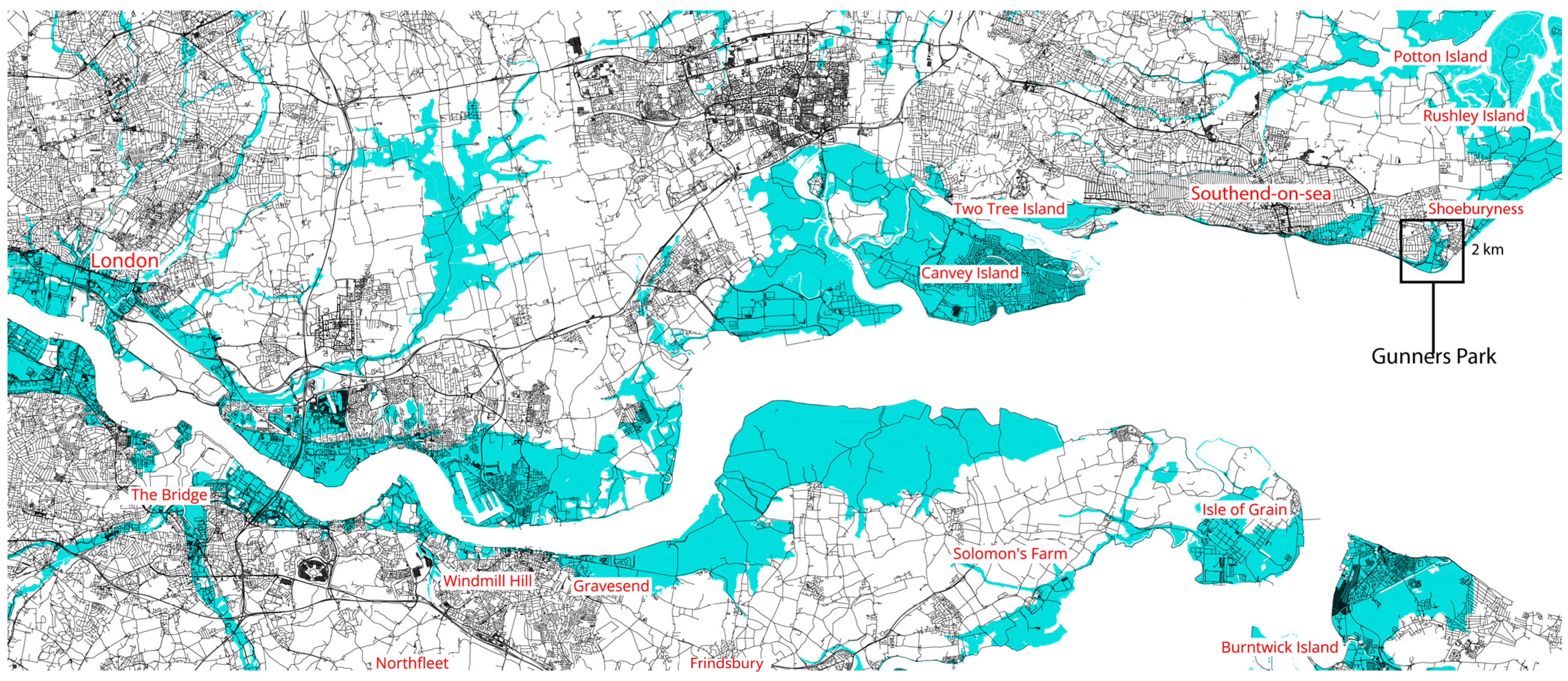
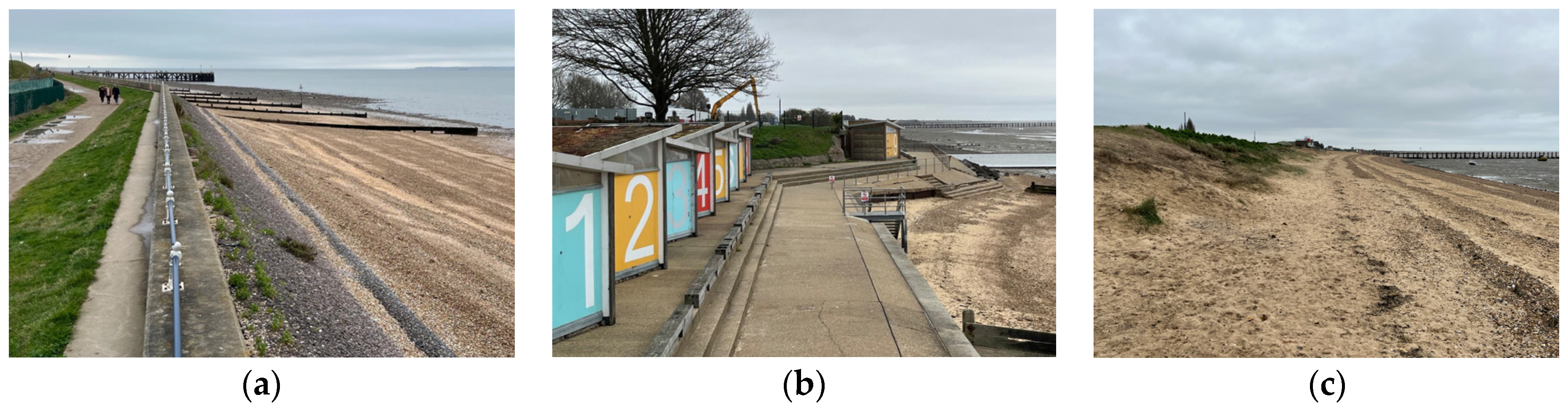
2. Flood Risk (Protection) in Shoeburyness, Southend-on-Sea (UK)
3. Methods and Tools
Numerical Approach
4. Results
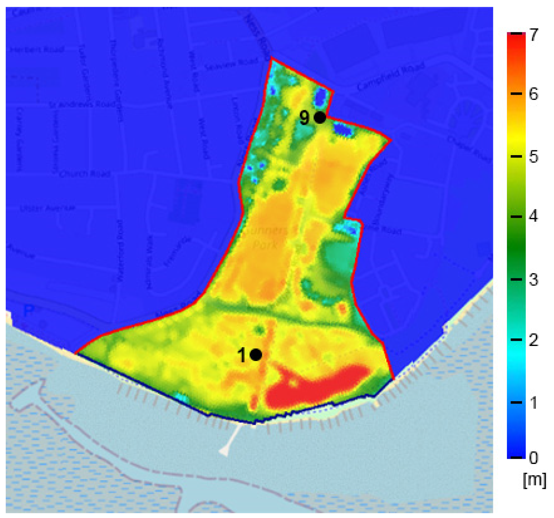
4.1. Seawall
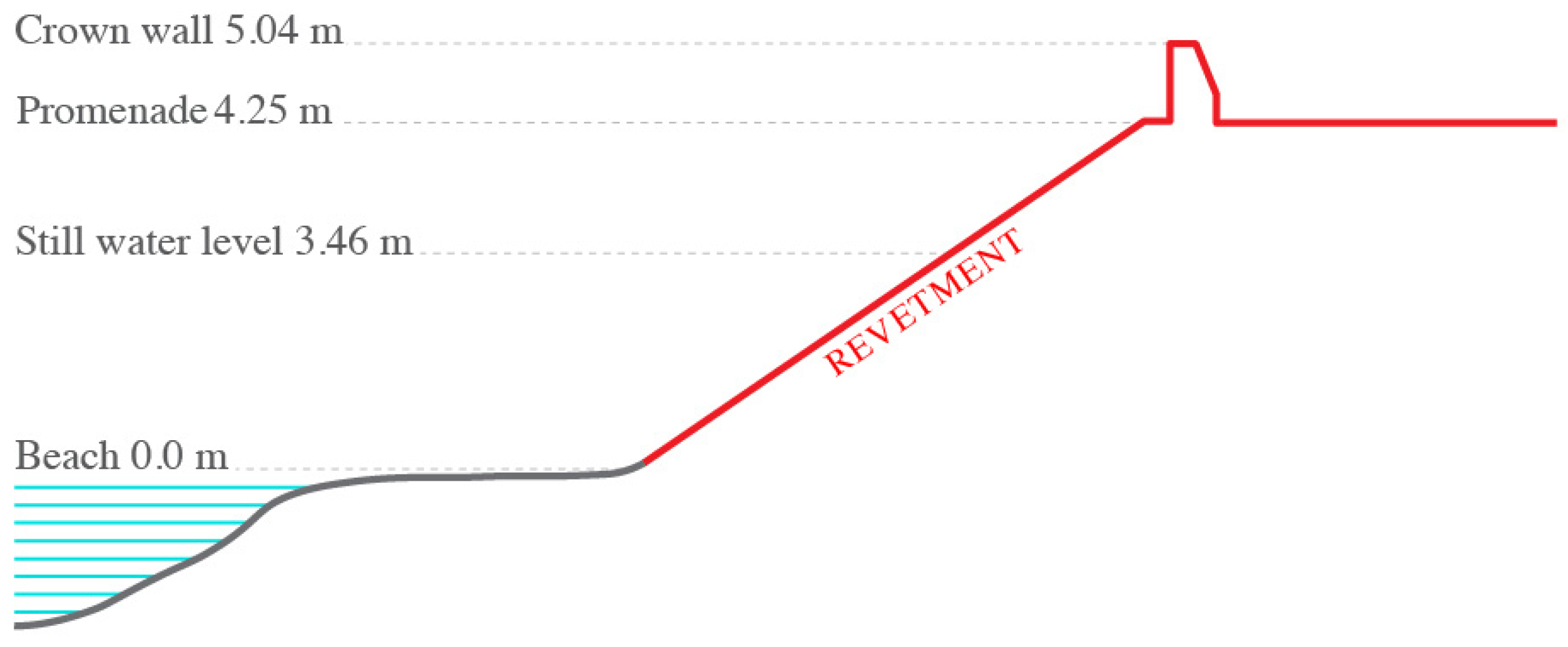
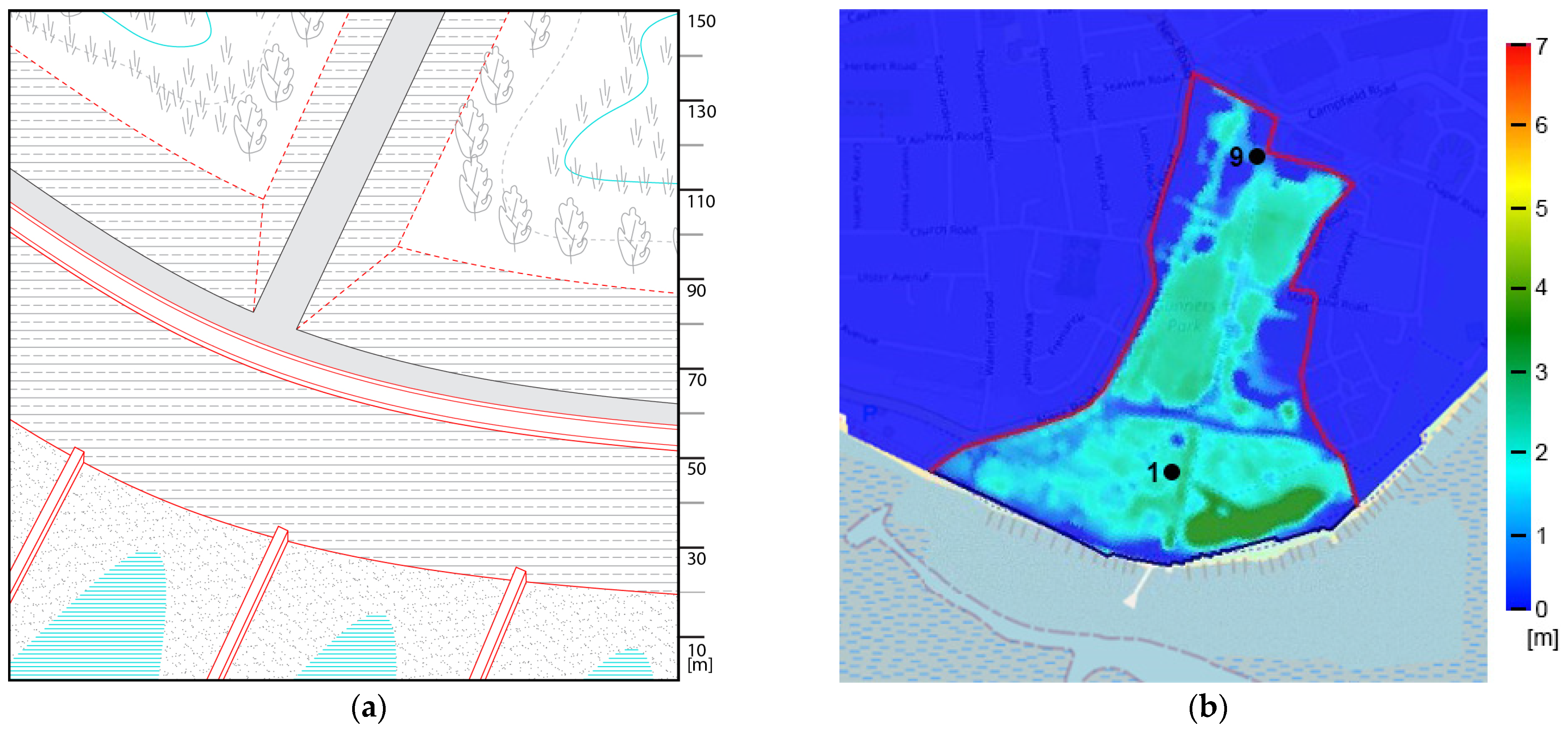
4.2. Rock Revetments
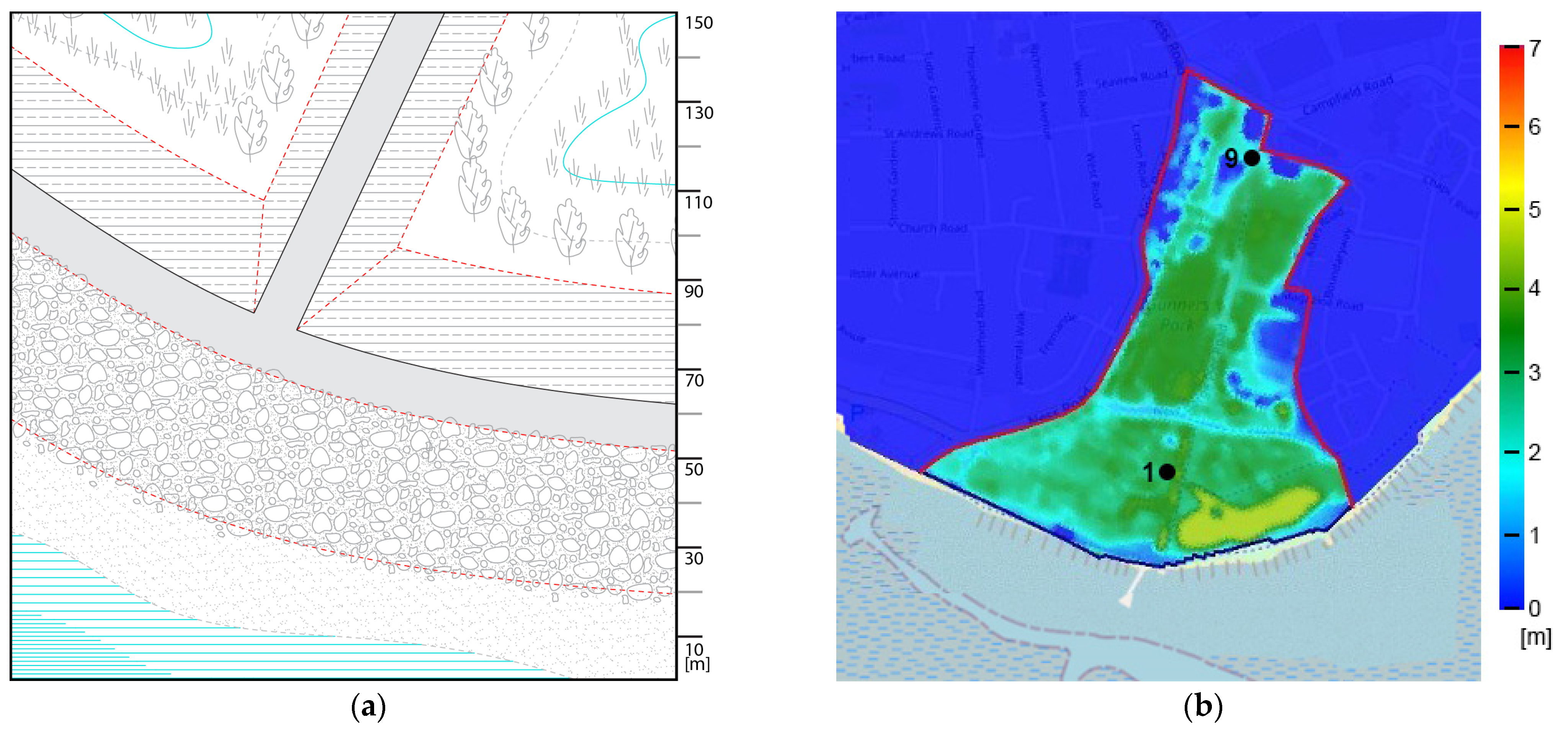
4.3. Stepped Revetment
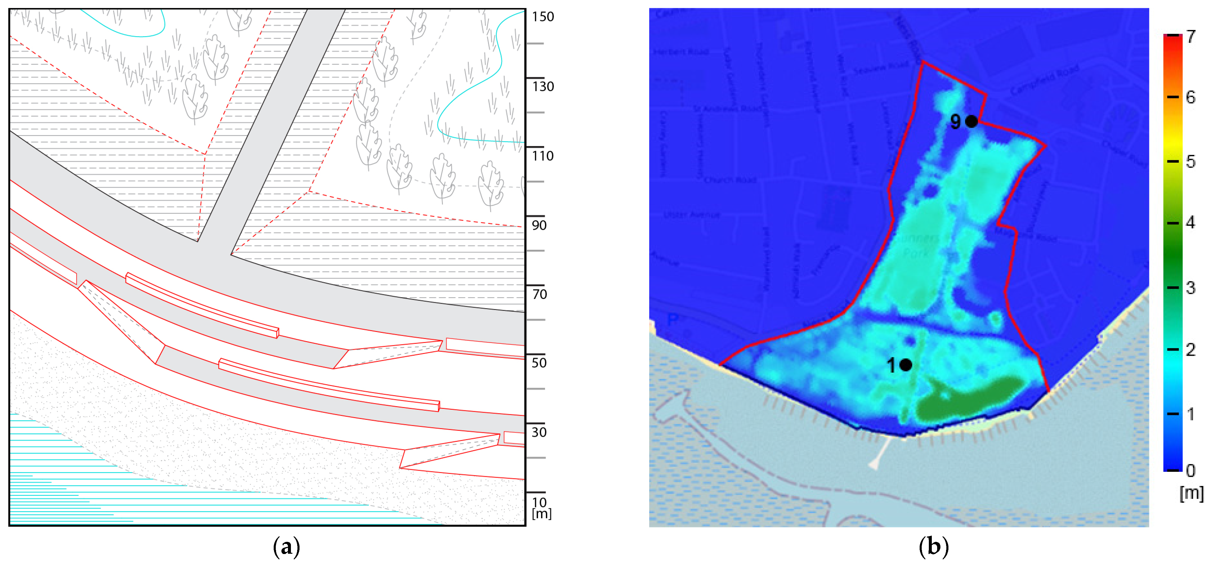
4.4. Vegetation
5. Discussion
6. Conclusions
Author Contributions
Funding
Acknowledgments
Conflicts of Interest
References
- IPCC. Climate Change. Synthesis Report. Contribution of Working Groups I, II and III to the Sixth Assessment Report of the Intergovernmental Panel on Climate Change. 2023. Available online: https://www.ipcc.ch/report/sixth-assessment-report-cycle/ (accessed on 2 January 2024).
- Lowe, J.A.; Bernie, D.; Bett, P.E.; Bricheno, L.; Brown, S.; Calvert, D.; Clark, R.T.; Eagle, K.E.; Edwards, T.; Fosser, G.; et al. UKCP18 Scientific Report; Met Office: Exeter, UK, 2018. Available online: https://www.metoffice.gov.uk/pub/data/weather/uk/ukcp18/science-reports/UKCP18-Overview-report.pdf (accessed on 2 January 2024).
- US Department of Commerce; National Oceanic and Atmospheric Administration. Global and Regional Sea Level Rise. Scenarios for the United States. Scientific Report. 2022. Available online: https://oceanservice.noaa.gov/hazards/sealevelrise/sealevelrise-tech-report-sections.html (accessed on 2 January 2024).
- KNMI. Klimaatscenario’s Voor Nederland. Scientific Report. 2023. Available online: https://www.knmi.nl/kennis-en-datacentrum/achtergrond/knmi-23-klimaatscenario-s-voor-gebruikers/ (accessed on 2 January 2024).
- CRED Center for Research on the Epidemiology of Disasters. The Human Cost of Disasters: An Overview of the Last 20 Years (2000–2019); UN Office for Disaster Risk Reduction: Geneva, Switzerland, 2020; Available online: https://www.preventionweb.net/files/74124_humancostofdisasters20002019reportu.pdf?_gl=1*1t4cp8b*_ga*OTI2NDU2NTMuMTcwNDYyOTQ0OQ..*_ga_D8G5WXP6YM*MTcwNDYyOTQ1MS4xLjAuMTcwNDYyOTQ1MS4wLjAuMA.. (accessed on 2 January 2024).
- Hood, G. Indirect Environmental Effects of Dikes on Estuarine Tidal Channels: Thinking Outside of the Dike for Habitat Restoration and Monitoring. Estuaries 2004, 27, 273–282. [Google Scholar] [CrossRef]
- Guerry, A.D.; Silver, J.; Beagle, J.; Wyatt, K.; Arkema, K.; Lowe, J.; Hamel, P.; Griffin, R.; Wolny, S.; Plane, E.; et al. Protection and restoration of coastal habitats yield multiple benefits for urban residents as sea levels rise. Urban Sustain. 2022, 2, 13. [Google Scholar] [CrossRef]
- Doelle, M.; Puthucherril, T.G. Nature-based solutions to sea level rise and other climate change impacts on oceanic and coastal environments: A law and policy perspective. Nord. J. Bot. 2021, 1, 1. [Google Scholar] [CrossRef]
- Lafortezza, R.; Chen, J.; Van Den Bosch, C.K.; Randrup, T.B. Nature-based solutions for resilient landscapes and cities. Environ. Res. 2018, 165, 431–441. [Google Scholar] [CrossRef] [PubMed]
- van Loon-Steensma, J.M.; Schelfhout, H.A. Wide Green Dikes: A sustainable adaptation option with benefits for both nature and landscape values? Land Use Policy 2017, 63, 528–538. [Google Scholar] [CrossRef]
- Leone, E.; Kobayashi, N.; Francone, A.; Bartolo, S.D.; Strafella, G.R. Use of Nanosilica for Increasing Dune Erosion Resistance during a Sea Storm. J. Mar. Sci. Eng. 2021, 9, 620. [Google Scholar] [CrossRef]
- Lawlor, P.; Jackson, D.W.T. A Nature-Based Solution for Coastal Foredune Restoration: The Case Study of Maghery, County Donegal, Ireland. In Human-Nature Interactions; Misiune, I., Depellegrin, D., Egarter Vigl, L., Eds.; Springer: Cham, Switzerland, 2022. [Google Scholar]
- Hanley, M.E.; Hoggart, S.P.G.; Simmonds, D.J.; Bichot, A.; Colangelo, M.A.; Bozzeda, F.; Heurtefeux, H.; Ondiviela, B.; Ostrowski, R.; Recio, M.; et al. Shifting sands? Coastal protection by sand banks, beaches and dunes. Coast. Eng. 2004, 87, 136–146. [Google Scholar] [CrossRef]
- Marijnissen, R.; Kok, M.; Kroeze, C.; van Loon-Steensma, J. Re-evaluating safety risks of multifunctional dikes with a probabilistic risk framework. Nat. Hazards Earth Syst. Sci. 2019, 19, 737–756. [Google Scholar] [CrossRef]
- Anvarifar, F.; Zevenbergen, C.; Thissen, W.; Islam, T. Understanding flexibility for multifunctional flood defences: A conceptual framework. J. Water Clim. Chang. 2017, 7, 467–484. [Google Scholar] [CrossRef]
- Anvarifar, F.; Oderkerk, M.; van der Horst, B.R.; Zevenbergen, C. Cost-effectiveness study on preventive interventions: A survey of multifunctional flood defences. In Comprehensive Flood Risk Management: Research for Policy and Practice; Klijn, F., Schweckendiek, T., Eds.; CRC Press: London, UK, 2013. [Google Scholar]
- de Jong, J.; van Rooy, P.T.; Hosper, S.H. Living with water: At the cross-roads of change. Water Sci. Technol. 1995, 31, 393–400. [Google Scholar] [CrossRef]
- Schoeman, J.; Allan, C.; Finlayson, C.M. A new paradigm for water? A comparative review of integrated, adaptive and ecosystem-based water management in the Anthropocene. Int. J. Water Resour. Dev. 2004, 30, 17–30. [Google Scholar] [CrossRef]
- Hurlimann, A.; Wilson, E. Sustainable Urban Water Management under a Changing Climate: The Role of Spatial Planning. Water 2018, 10, 546. [Google Scholar] [CrossRef]
- Iuorio, L.; Bortolotti, A. Integrated coastal flood design strategies. Changing paradigm in flood risk management. Int. Forum Urban. 2021. [Google Scholar] [CrossRef]
- Franco-Torres, M.; Rogers, B.C.; Harder, R. Articulating the new urban water paradigm. Crit. Rev. Environ. Sci. Technol. 2021, 51, 2777–2823. [Google Scholar] [CrossRef]
- Wüthrich, D.; Teng, D.; Ke, Q.; Diaz, A.; Bortolotti, A.; Iuorio, L.; Hooimeijer, F. Sustainable and Resilient Coastal Cities (SARCC): Interdisciplinary flood protection strategies in Southend-on-Sea (UK). In Proceedings of the 39th IAHR World Congress, Granada, Spain, 19–24 June 2022. [Google Scholar]
- Hooimeijer, F.; Diaz, A.; Bortolotti, A.; Ke, Q.; van der Heuvel, J.; Bricker, J. Design & Assessing the flood risk management paradigm shift: An interdisciplinary study of Vlissingen, The Netherlands. J. Urban. 2021. [Google Scholar] [CrossRef]
- TAW. Technical Report Wave Run-Up and Wave Overtopping at Dikes; Technical Advisory Committee on Flood Defence: Delft, The Netherlands, 2002. [Google Scholar]
- Van der Meer, J.W.; Allsop, N.W.H.; Bruce, T.; De Rouck, J.; Kortenhaus, A.; Pullen, T.; Schüttrumpf, H.; Troch, P.; Zanuttigh, B. Manual on Wave Overtopping of Sea Defences and Related Structures; An Overtopping Manual Largely Based on European Research, but for Worldwide Application; EurOtop; 2018; Available online: http://www.overtopping-manual.com/assets/downloads/EurOtop_II_2016_Pre-release_October_2016.pdf (accessed on 2 January 2024).
- van Gent, M.R.; Wolters, G.; Capel, A. Wave overtopping discharges at rubble mound breakwaters including effects of a crest wall and a berm. Coast. Eng. 2022, 176, 104151. [Google Scholar] [CrossRef]
- Chen, W.; Van Gent, M.R.A.; Warmink, J.J.; Hulscher, S.J.M.H. The influence of a berm and roughness on the wave overtopping at dikes. Coast. Eng. 2020, 156, 103613. [Google Scholar] [CrossRef]
- Schoonees, T.; Kerpen, N.B.; Schlurmann, T. Full-scale experimental study on wave overtopping at stepped revetments. Coast. Eng. 2021, 167, 103887. [Google Scholar] [CrossRef]
- Southend-On-Sea, City Council. Available online: https://www.southend.gov.uk/equality-diversity-0/within-southend (accessed on 2 January 2024).
- Southend-On-Sea Borough Council. Character Study; Urban Practitioners: Southend-On-Sea, UK, 2011. [Google Scholar]
- AECOM. South Essex Level 1 Strategic Flood Risk Assessment; Final Report; 2018. Available online: https://localplan.southend.gov.uk/sites/localplan.southend/files/2019-02/South%20Essex%20Strategic%20Flood%20Risk%20Assessment%20Level%201.pdf (accessed on 2 January 2024).
- Thames Estuary 2100. Managing Flood Risk through London and the Thames Estuary; Report; Environmental Agency: Bristol, UK, 2012. [Google Scholar]
- ASELA. Growth and Recovery Prospectus; Report; Association of South Essex Local Authorities, 2020. Available online: https://localplan.southend.gov.uk/sites/localplan.southend/files/2021-08/ASELA%20Growth%20and%20Recovery%20Prospectus%2013%20July%202020%20%281%29.pdf (accessed on 2 January 2024).
- Essex County Council. Essex Infrastructure Strategy. A Strategy That Champions for High Quality Green Space and Green Infrastructure in Essex. Report. 2020. Available online: https://www.placeservices.co.uk/media/325323/EGIS_MainStrategy_09062020-LR.pdf (accessed on 2 January 2024).
- Wüthrich, D.; Pfister, M.; Nistor, I.; Schleiss, A.J. Experimental study on forces exerted on buildings with openings due to extreme hydrodynamic events. Coast. Eng. 2018, 140, 72–86. [Google Scholar] [CrossRef]
- Pilarczyk, K. Dikes and Revetments: Design, Maintenance and Safety Assessment; Routledge: London, UK, 2017. [Google Scholar]
- Hofland, B.; Arefin, S.S.; van der Lem, C.; Van Gent, M.R. Smart rocking armour units. In Proceedings of the 7th International Conference on the Application of Physical Modelling in Coastal and Port Engineering and Science, Coastlab 18, Santander, Cantabria, Spain, 22–26 May 2018. [Google Scholar]
- Vieira, F.; Taveira-Pinto, F.; Rosa-Santos, P. Single-layer cube armoured breakwaters: Critical review and technical challenges. Ocean. Eng. 2020, 216, 108042. [Google Scholar] [CrossRef]
- Vuik, V.; Jonkman, S.N.; Borsje, B.W.; Suzuki, T. Nature-based flood protection: The efficiency of vegetated foreshores for reducing wave loads on coastal dikes. Coast. Eng. 2016, 116, 42–56. [Google Scholar] [CrossRef]
- Maza, M.; Lara, J.L.; Losada, I.J. Experimental analysis of wave attenuation and drag forces in a realistic fringe Rhizophora mangrove forest. Adv. Water Resour. 2019, 131, 103376. [Google Scholar] [CrossRef]
- van Wesenbeeck, B.K.; Wolters, G.; Antolínez, J.A.; Kalloe, S.A.; Hofland, B.; de Boer, W.P.; Bouma, T.J. Wave attenuation through forests under extreme conditions. Sci. Rep. 2022, 12, 1884. [Google Scholar] [CrossRef]
- Pullen, T.; Allsop, N.W.H.; Bruce, T.; Kortenhaus, A.; Schüttrumpf, H.; Van der Meer, J.W. EurOtop Wave Overtopping of Sea Defences and Related Structures; Assessment Manual; 2007; Available online: https://www.researchgate.net/publication/256197945_EurOtop_Wave_Overtopping_of_Sea_Defences_and_Related_Structures_Assessment_Manual (accessed on 2 January 2024).
- Church, J.A.; Clark, P.U.; Cazenave, A.; Gregory, J.M.; Jevrejeva, S.; Levermann, A.; Merrifield, M.A.; Milne, G.A.; Nerem, R.S.; Nunn, P.D.; et al. Sea Level Change. In Climate Change 2013: The Physical Science Basis; Contribution of Working Group 1 to the Fifth Assessment Report of the Intergovernmental Panel on Climate Change; Cambridge University Press: Cambridge, UK; New York, NY, USA, 2013. [Google Scholar]
- Palmer, M.; Howard, T.; Tinker, J.; Lowe, J.; Bricheno, L.; Calvert, D.; Edwards, T.; Gregory, J.; Harris, G.; Krijnen, J.; et al. UKCP18. Marine Report. 2018. Available online: https://www.metoffice.gov.uk/binaries/content/assets/metofficegovuk/pdf/research/ukcp/ukcp18-marine-report-updated.pdf (accessed on 2 January 2024).
- Meinshausen, M.; Smith, S.J.; Calvin, K.V.; Daniel, J.S.; Kainuma, M.L.T.; Lamarque, J.-F.; Matsumoto, K.; Montzka, S.A.; Raper, S.C.B.; Riahi, K.; et al. The RCP Greenhouse Gas Concentrations and their Extension from 1765 to 2300. Clim. Chang. 2013, 109, 213. [Google Scholar] [CrossRef]
- Pranzini, E. Coastal erosion and shore protection: A brief historical analysis. J. Coast. Conserv. 2018, 22, 827–830. [Google Scholar] [CrossRef]
- van den Hoven, K.; Kroeze, C.; van Loon-Steensma, J.M. Characteristics of realigned dikes in coastal Europe: Overview and opportunities for nature-based flood protection. Ocean. Coast. Manag. 2022, 222, 106116. [Google Scholar] [CrossRef]
- Marijnissen, R.J.C.; Kok, M.; Kroeze, C.; van Loon-Steensma, J.M. Flood risk reduction by parallel flood defences. Case-study of a coastal multifunctional flood protection zone. Coast. Eng. 2021, 167, 103903. [Google Scholar] [CrossRef]
- Chanson, H. The Hydraulics of Stepped Chutes and Spillways; Balkema: Lisse, The Netherlands, 2001. [Google Scholar]
- Wüthrich, D.; Chanson, H. Hydraulics, air entrainment, and energy dissipation on a Gabion stepped weir. J. Hydraul. Eng. 2014, 140, 04014046. [Google Scholar] [CrossRef]
- Kerpen, N.B.; Schoonees, T.; Schlurmann, T. Wave overtopping of stepped revetments. Water 2019, 11, 1035. [Google Scholar] [CrossRef]


| Measure | Water Depth at Point 1 [m] | Water Depth at Point 9 [m] | Stored Volume [m3] | Spatial Functionality and Quality | Integration of Measures within the Urban Landscape |
|---|---|---|---|---|---|
| Seawall | 2.05 | 0.52 | 717,285 | The wall obstructs the view and access to beach; it requires the redefinition of the mobility systems | The wall enhances the separation between the engineering protection infrastructure and the urban settlement |
| Rocks | 3.32 | 1.79 | 1,229,801 | Rocks are not accessible to humans but provide habitats for maritime flora and fauna | The use of local material (rocks or stone) may result as a good solution to aesthetically integrate the dike within the landscape |
| Steps | 1.51 | - | 519,243 | Steps might provide new space for public functions when no extreme events occur | Steps might enhance the use of the dike in its multifunctional dimension while still appearing as a separation between land and water |
| Vegetation | 4.83 | 3.29 | 1,867,849 | Vegetation provides a new habitat for fauna; limited access for activities | Native flora can recreate the lost ecological and functional land–water connection |
| Spatial Configuration | Max Water Level at Point 1 [m] | Max Water Level at Point 9 [m] |
|---|---|---|
| 25% wall (5.4 m) + 25% rock revetment + 25% stepped revetment + 25% vegetation | 2.97 | 1.44 |
| 50% step + 50% vegetation | 3.23 | 1.70 |
| 50% seawall (5.4 m) + 50% steps | 1.78 | 0.25 |
| 50% rock + 50% vegetation | 4.07 | 2.54 |
Disclaimer/Publisher’s Note: The statements, opinions and data contained in all publications are solely those of the individual author(s) and contributor(s) and not of MDPI and/or the editor(s). MDPI and/or the editor(s) disclaim responsibility for any injury to people or property resulting from any ideas, methods, instructions or products referred to in the content. |
© 2024 by the authors. Licensee MDPI, Basel, Switzerland. This article is an open access article distributed under the terms and conditions of the Creative Commons Attribution (CC BY) license (https://creativecommons.org/licenses/by/4.0/).
Share and Cite
Iuorio, L.; Wüthrich, D.; Teng, D.; Hooimeijer, F. Spatial Design Thinking in Coastal Defence Systems: Overtopping Dikes in Southend-On-Sea. J. Mar. Sci. Eng. 2024, 12, 121. https://doi.org/10.3390/jmse12010121
Iuorio L, Wüthrich D, Teng D, Hooimeijer F. Spatial Design Thinking in Coastal Defence Systems: Overtopping Dikes in Southend-On-Sea. Journal of Marine Science and Engineering. 2024; 12(1):121. https://doi.org/10.3390/jmse12010121
Chicago/Turabian StyleIuorio, Luca, Davide Wüthrich, Djimin Teng, and Fransje Hooimeijer. 2024. "Spatial Design Thinking in Coastal Defence Systems: Overtopping Dikes in Southend-On-Sea" Journal of Marine Science and Engineering 12, no. 1: 121. https://doi.org/10.3390/jmse12010121